A Web Application That Can Save You Money
|
|
|
- Linda Evans
- 5 years ago
- Views:
Transcription
1 Esri Southwest Conference December 2-4, 2014 Santa Fe, NM A Web Application That Can Save You Money Colleen Swain, Swain GIS Services, LLC Brian Zheng, East Bay Municipal Utility District


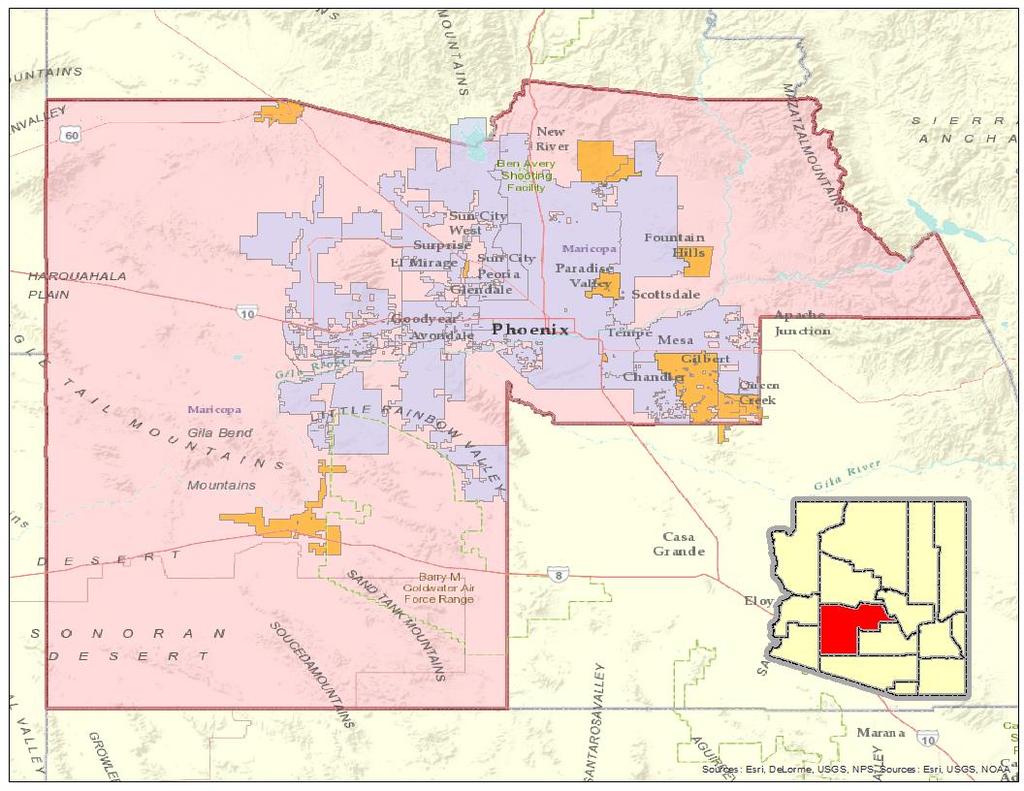
2 Problem Background Applicable to Cities & Counties Architecture Application Training and Costs Benefits Conclusion
3 Lack of coordination between Cities, Counties, and Utilities for work being done in the streets. Citizens have to deal with multiple road construction projects done over a long period of time on the same road. No sharing of costs amongst agencies and utilities

4 First a City/County Paves a Street This takes about 2 weeks


5 Then a Water Utility comes in and installs a pipe in the street. This takes about 3 more weeks


6 Then an Electric or Gas Utility comes in and installs a pipe in the street. This takes about 3 more weeks


7 So the Citizens dealt with approximately 8 weeks of construction and in the end the road pavement was patched up.
 Facilitate Coordination Share Costs Pilot Project -- CCCSD, Danville, and EBMUD with feedback from the Utility")
8 Utility Coalition Meeting Individual Excel spreadsheets Discussion with no visuals Idea (EBMUD) GIS Web Application (Visual) Facilitate Coordination Share Costs Pilot Project -- CCCSD, Danville, and EBMUD with feedback from the Utility Coalition

9


10 City Water Dept. City Public Works
11 WIS is a GIS Web application developed by EBMUD in coordination with selected agencies It provides a map Web platform for agencies to coordinate street work and projects It enables the agencies to add, edit, and locate their internal projects It also allows agencies to view projects added by other agencies
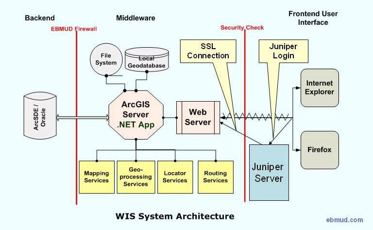
12 Fire Wall
13 Front End User Interface It is a Web GIS application supporting different browsers Middle Tier ArcGIS Server.NET ADF Excel spreadsheet loader and project data editing Overlaid projects searching and locating ArcGIS Server Services Mapping service Geocoding service Routing service Geoprocessing service Back End ArcSDE/Oracle GeoDatabase
14 User Login - Security Mapping Navigation Tools Project Finding and Locating tools Project Data Loading and Editing Tools Overlaid (Conflict) Project Searching Tools WIS Online Help
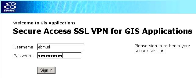
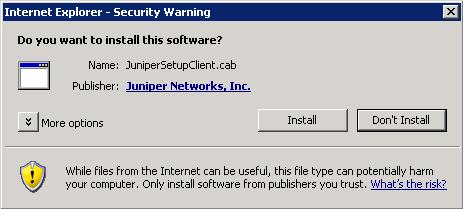
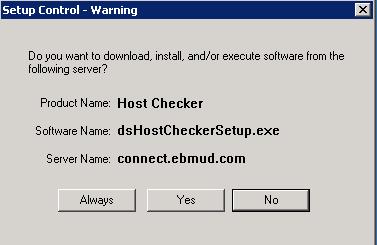
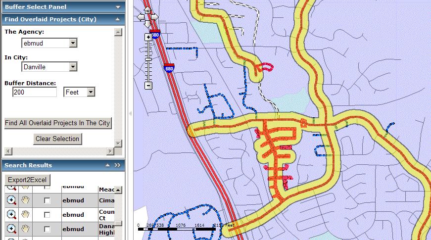
15 Juniper Connection


16 There are two accounts; one Admin for editing and one for View only
17 With a signed Data Sharing agreement you go directly to the application Otherwise the users will need to accept the Online Agreement
 Links")
18 Menu/Toolbar Map (or Map Frame) Links Console
19 Re-Center the Map Navigation element Pan tool Zoom in / out Mouse wheel Zoom in tool Zoom out tool Zoom level Zoom scale dropdown Mouse wheel
20 Forward or Back Extent Forward extent Back extent Zoom out to full map Measure distance and area Measure polyline Measure polygon


21 Identify a WIS Project or a Feature Find Projects Find Street

22 Find Place Name Find Address or Street Intersection Find Parcel APN

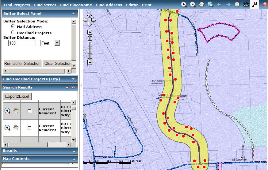
23 Search Results Panel is used to display the found records for the WIS project find and search tools Export to an Excel spreadsheet Zoom in to Project Pan to Project Highlight Project on map
24 Need to be logged in as Admin user for your organization Start and Stop editing by clicking on the menu bar and clicking on the Editor task Window. Stop editing will automatically save all your newly created projects and edits on existing ones


25 Select Feature Clear Features Show Vertices Enter XY Create Feature Move Feature Copy Feature Split Feature Merge Feature Delete Feature Add Vertex Delete Vertex Move Vertex
 for")
26 After creating a Project (feature) by double clicking the end point, the Attribute Information Panel appears There are fields that need to be filled in prior to saving it You can later modify the attribute information by selecting the project (feature) for editing

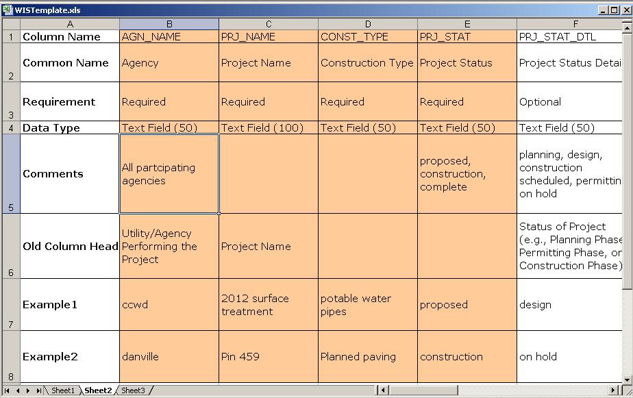
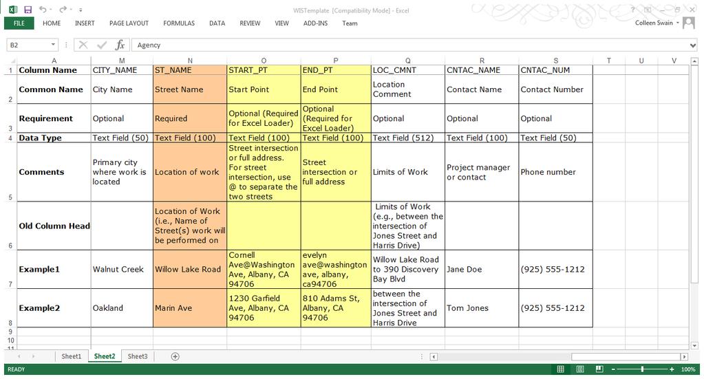
27 A way to load in bulk data as projects in standard Excel spreadsheet into the database Uses the Routing Services to generate the project polylines The application provides an Excel spreadsheet template that can be down loaded onto a users PC
28
29


30 First step is to check for any errors in spreadsheet Example of error message


31 Once the errors have been corrected then the Upload Button will be enabled. When upload is complete you will see your projects on the map.

32 Find all the overlaid projects from a selected project

33

34
35


36 Agencies can gain access to WIS by coming to a free ½ day class and either sign a data sharing agreement or using the online agreement Once training is provided than a username and temporary password will be given to the participant WIS Access


37 EBMUD provides the hardware and software Cost for ArcGIS Server license and yearly maintenance Cost for yearly license of NAVTEQ data Initial cost for 1 GIS Programmer for 1 year development Cost for training and maintenance on the application For participants the cost is

 for an event Can save money by --")
38 Better coordination between Counties, Cities, and Utilities It is easier to find and see who is doing what projects around your project(s). Coordination of street closure(s) for an event Can save money by -- Sharing paving costs Paving Moratorium costs Savings on staff time


39 26 Agencies use the application Sharing of costs has occurred between cities and utilities Application has been in production for over 4 years Recently has been upgraded to 10.1 Future ArcGIS Online Questions
SECTION GEOGRAPHIC INFORMATION SYSTEM (GIS)
") PART 1 - GENERAL 1.1 DESCRIPTION SECTION 11 83 01 A. Provide all labor, materials, manpower, tools and equipment required to furnish, install, activate and test a new Geographic Information System (GIS).
PART 1 - GENERAL 1.1 DESCRIPTION SECTION 11 83 01 A. Provide all labor, materials, manpower, tools and equipment required to furnish, install, activate and test a new Geographic Information System (GIS).
ArcGIS 9 Using ArcGIS StreetMap
 ArcGIS 9 Using ArcGIS StreetMap Copyright 2001 2004 ESRI All Rights Reserved. Printed in the United States of America. The information contained in this document is the exclusive property of ESRI. This
VGIN Geocoding Service
 VGIN Geocoding Service What is Geocoding? Geocoding is the process of assigning geographic coordinates (e.g., latitude and longitude) to data records such as street addresses. With geographic coordinates,
Public Safety Routing Using ArcGIS Online and HERE Data
 Public Safety Routing Using ArcGIS Online and HERE Data Knowledge, Skills, and Abilities (KSAs) Supported This training module develops several KSAs that are fundamental to using GIS to support public
10.2. Scanning Document Camera Scoring. Page 1 of 5. How do I score answer sheets using a document camera? STEP 1
 Step by Step How do I score answer sheets using a document camera? STEP 1 Click on the Assessment icon in the top navigation bar. STEP 2 To locate your assessment in an assessment list, first select the
Hyperion System 9 Financial Data Quality Management. Quick Reference Guide
 Hyperion System 9 Financial Data Quality Management Quick Reference Guide Hyperion FDM Release 9.2.0. 2000 2006 - Hyperion Solutions Corporation. All rights reserved. Hyperion, the Hyperion logo and Hyperion
Air Navigation Race Scoring & Visualisation Software
 Air Navigation Race Scoring & Visualisation Software User manual V0.2 Table of contents 1 Introduction... 3 2 Installing the ANR Software... 3 3 Getting Started... 4 4 Managing Competitions... 5 5 Maps...
DocuSign for Sugar 7 v1.0. Overview. Quick Start Guide. Published December 5, 2013
 Quick Start Guide DocuSign for Sugar 7 v1.0 Published December 5, 2013 Overview This guide provides information on installing and signing documents with DocuSign for Sugar7. The Release Notes for DocuSign
Descartes Map Editor November 2013 U S E R S G U I D E
 Descartes Map Editor 13.2.1 November 2013 Toll Free 800.419.8495 Int l 519.746.8110 info@descartes.com www.descartes.com 2013 The Descartes Systems Group Inc. All rights reserved Information in this document
EDUCATION GIS CONFERENCE Geoprocessing with ArcGIS Pro. Rudy Prosser GISP CTT+ Instructor, Esri
 EDUCATION GIS CONFERENCE Geoprocessing with ArcGIS Pro Rudy Prosser GISP CTT+ Instructor, Esri Maintenance What is geoprocessing? Geoprocessing is - a framework and set of tools for processing geographic
A step-by-step process for attaching a photo of the park through Android Mobile Application
 A step-by-step process for attaching a photo of the park through Android Mobile Application Feedback is registered by the customer with the details of the customer and park through web based enabled application
Building Java Apps with ArcGIS Runtime SDK
 Building Java Apps with ArcGIS Runtime SDK Vijay Gandhi, Elise Acheson, Eric Bader Demo Source code: https://github.com/esri/arcgis-runtime-samples-java/tree/master/devsummit-2014 Video Recording: http://video.esri.com
UNIGIS University of Salzburg. Module: ArcGIS for Server Lesson: Online Spatial analysis UNIGIS
 1 Upon the completion of this presentation you should be able to: Describe the geoprocessing service capabilities Define supported data types input and output of geoprocessing service Configure a geoprocessing
Ansible Tower Quick Setup Guide
 Ansible Tower Quick Setup Guide Release Ansible Tower 3.2.2 Red Hat, Inc. Mar 08, 2018 CONTENTS 1 Quick Start 2 2 Login as a Superuser 3 3 Import a License 5 4 Examine the Tower Dashboard 7 5 The Settings
THE LIST USABILITY PUG 2007
 THE LIST USABILITY PUG 2007 Layer/Map Management Working with many layers, maps and data sets Direction that ESRI is taking with the Geodatabase Information Model Direction that ESRI is taking with GIS
Street Canyon Tool. User Guide CERC
 Street Canyon Tool User Guide CERC ADMS Street Canyon Tool Version 2.0 User Guide August 2018 Cambridge Environmental Research Consultants Ltd. 3, King s Parade Cambridge CB2 1SJ UK Telephone: +44 (0)1223
Ansible Tower Quick Setup Guide
 Ansible Tower Quick Setup Guide Release Ansible Tower 3.1.3 Red Hat, Inc. Feb 27, 2018 CONTENTS 1 Quick Start 2 2 Login as a Superuser 3 3 Import a License 5 4 Examine the Tower Dashboard 7 5 The Settings
ARCGIS DESKTOP DEMO (GEOCODING, SERVICE AREAS, TABULAR & SPATIAL JOINS)
") ARCGIS DESKTOP DEMO (GEOCODING, SERVICE AREAS, TABULAR & SPATIAL JOINS) Indiana State GIS Day Conference: September 22, 2015 ASHLEY SUITER GIS Data Analyst Epidemiology Resource Center Indiana State Department
ARCGIS DESKTOP DEMO (GEOCODING, SERVICE AREAS, TABULAR & SPATIAL JOINS) Indiana State GIS Day Conference: September 22, 2015 ASHLEY SUITER GIS Data Analyst Epidemiology Resource Center Indiana State Department
Qt Developing ArcGIS Runtime Applications. Eric
 Qt Developing ArcGIS Runtime Applications Eric Bader @ECBader Agenda Getting Started Creating the Map Geocoding and Routing Geoprocessing Message Processing Working Offline The Next Release What s Coming
An ESRI White Paper May 2009 ArcGIS 9.3 Geocoding Technology
 An ESRI White Paper May 2009 ArcGIS 9.3 Geocoding Technology ESRI 380 New York St., Redlands, CA 92373-8100 USA TEL 909-793-2853 FAX 909-793-5953 E-MAIL info@esri.com WEB www.esri.com Copyright 2009 ESRI
PaperCut PaperCut Payment Gateway Module - CardSmith Quick Start Guide
 PaperCut PaperCut Payment Gateway Module - CardSmith Quick Start Guide This guide is designed to supplement the Payment Gateway Module documentation and provides a guide to installing, setting up and testing
Fundamentals of ModelBuilder
 Fundamentals of ModelBuilder Agenda An Overview of Geoprocessing Framework Introduction to ModelBuilder Basics of ArcToolbox Using ModelBuilder Documenting Models Sharing Models with Others Q & A Geoprocessing
2.1 Introduction. Purpose. Scope
 SOFTWARE REQUIREMENT SPECIFICATION 2.1 Introduction Chennemane is a traditional folk game of Dakshina Kannada. In this project we are going to implement the game and preserve the traditionalism of our
Scorer with BridgePads Quick Guide to Teams Scoring
 December 2013, Scorer 14 Scorer with BridgePads Quick Guide to Teams Scoring These instructions a short guide to Teams scoring. Only the most common functions are covered. For details on more advanced
Manager Client. User Guide V
 Manager Client User Guide V1.25 www.mobiletornado.com pushtoexperience Introduction Manager Client provides the ability to manage communications within an organisation, view mobile devices live and historic
uiulearn TUTORIAL INTEGRATIONS> HOW TO USE PANOPTO (STUDENT)
") uiulearn TUTORIAL INTEGRATIONS> HOW TO USE PANOPTO (STUDENT) This tutorial covers how to record a Panopto video for your course. IN ORDER TO DO THIS, YOUR INSTRUCTOR MUST COMPLETE SEVERAL STEPS TO ALLOW
uiulearn TUTORIAL INTEGRATIONS> HOW TO USE PANOPTO (STUDENT) This tutorial covers how to record a Panopto video for your course. IN ORDER TO DO THIS, YOUR INSTRUCTOR MUST COMPLETE SEVERAL STEPS TO ALLOW
New Sketch Editing/Adding
 New Sketch Editing/Adding 1. 2. 3. 4. 5. 6. 1. This button will bring the entire sketch to view in the window, which is the Default display. This is used to return to a view of the entire sketch after
Accessing e-books with your e-reader
 e-reader 1 Accessing e-books with your e-reader What you need to know about library e-books is that each one is protected by Digital Rights Management (DRM). This means that access to e-books is restricted
Catholic Education Center, LLC User Manual. If you need further assistance, please
 1 Catholic Education Center, LLC User Manual If you need further assistance, please email: catholiceducationcenter@yahoo.com or, telephone: 703-785-2319 (M-F: 9-5) Getting Started. Using your internet
Using the Desktop Recorder
 Mediasite Using the Desktop Recorder Instructional Media publication: 09-Students 9/8/06 Introduction The new Desktop Recorder from Mediasite allows HCC users to record content on their computer desktop
Geocoding An Introduction
 2013 Esri International User Conference July 8 12, 2013 San Diego, California Technical Workshop Geocoding An Introduction Miriam Schmidts Agatha Wong Esri UC2013. Technical Workshop. Agenda What is geocoding?
PaperCut PaperCut Payment Gateway Module - CBORD Data Xchange Quick Start Guide
 PaperCut PaperCut Payment Gateway Module - CBORD Data Xchange Quick Start Guide This guide is designed to supplement the Payment Gateway Module documentation and provides a guide to installing, setting
METRO TILES (SHAREPOINT ADD-IN)
") METRO TILES (SHAREPOINT ADD-IN) November 2017 Version 2.6 Copyright Beyond Intranet 2017. All Rights Reserved i Notice. This is a controlled document. Unauthorized access, copying, replication or usage
METRO TILES (SHAREPOINT ADD-IN) November 2017 Version 2.6 Copyright Beyond Intranet 2017. All Rights Reserved i Notice. This is a controlled document. Unauthorized access, copying, replication or usage
Infographics: Display Data for Easy Interpretation
 Infographics: Display Data for Easy Interpretation Course objectives: Create new infographics Customise layouts Edit content using text, images, media, charts and maps Publish, Present and Print Student
GD.FINDI FUNCTIONS OVERVIEW
 GD.FINDI FUNCTIONS OVERVIEW ASSOC. PROF. DR. CHAWALIT JEENANUNTA HEAD OF CENTER FOR DEMONSTRATION AND TECHNOLOGY TRANSFER OF INDUSTRY 4.0 HEAD OF LOGISTICS AND SUPPLY CHAIN SYSTEM ENGINEERING RESEARCH
G E O S E R V E R I N S TA L L
 G E O S E R V E R I N S TA L L Installation and Configuration of GeoServer 01 January 2009 TABLE OF CONTENTS 1 Goals...3 2 Java Development Kit Install:...4 3 Set JAVA_HOME...6 4 GeoServer install...7
PaperCut PaperCut Payment Gateway Module - Blackboard Quick Start Guide
 PaperCut PaperCut Payment Gateway Module - Blackboard Quick Start Guide This guide is designed to supplement the Payment Gateway Module documentation and provides a guide to installing, setting up and
Lab#2: Five Dimensions of GIS Data
 NRM338 Fall 2018 Lab#1 Page#1 of 13 Lab#2: Five Dimensions of GIS Data In this lab, we will explore five basic dimensions of GIS data Location or position Length and Area Measures (M-dimension) Elevation
Public Safety Geocoding Using ArcGIS Online and HERE Data
 Public Safety Geocoding Using ArcGIS Online and HERE Data I. Knowledge, Skills, and Abilities (KSAs) Supported This training module aids in the development of several KSAs that are fundamental to using
WEB I/O. Wireless On/Off Control USER MANUAL
 Wireless On/Off Control Technical Support: Email: support@encomwireless.com Toll Free: 1 800 617 3487 Worldwide: (403) 230 1122 Fax: (403) 276 9575 Web: www.encomwireless.com Warnings and Precautions Warnings
University of Massachusetts Amherst * Boston * Dartmouth * Lowell * President s Office * Worcester
 Running nvision User Executed Reports In order to run an nvision report it is necessary to establish a scope with ChartField values to apply to a Report Request. The report scope defines the ChartFIeld
Quick Guide for ArcReader GIS Installation & Use
 Town of Hanover Planning Department Quick Guide for ArcReader GIS Installation & Use For more information, contact the Town Planner, Andrew Port (781-826-7641) or port.planning@hanover-ma.gov System Requirements
EG1003 Help and How To s: Revit Tutorial
 EG1003 Help and How To s: Revit Tutorial Completion of this tutorial is required for Milestone 1. Include screenshots of it in your Milestone 1 presentation. Downloading Revit: Before beginning the tutorial,
Kodiak Corporate Administration Tool
 AT&T Business Mobility Kodiak Corporate Administration Tool User Guide Release 8.3 Table of Contents Introduction and Key Features 2 Getting Started 2 Navigate the Corporate Administration Tool 2 Manage
How Does it Work? PaperCut is an easy to use web based program. It s installed on just one Server or PC, and works on a per user basis.
 1 PaperCut Print Management software helps you save money and reduce printer waste in your business, school, college or professional services organisation. Put simply, PaperCut is a software solution that
Hydraulics and Floodplain Modeling Managing HEC-RAS Cross Sections
 WMS 10.1 Tutorial Hydraulics and Floodplain Modeling Managing HEC-RAS Cross Sections Modify cross sections in an HEC-RAS model to use surveyed cross section data v. 10.1 Objectives Build a basic HEC-RAS
Lab Assignment 5 Geoprocessing Service. Due Date: 01/24/2014
 Lab Assignment 5 Geoprocessing Service Due Date: 01/24/2014 Overview Geoprocessing is one of the original purposes or functions when GIS was invented. It provides tools and a framework for performing analysis
QUICK START GUIDE. A visual walk-through
 QUICK START GUIDE A visual walk-through 2 Contents Quick Overview 3 How to Log In 4 How the Website Works 5 How to Get the Next Step 9 Checking Your Account 16 Troubleshooting 19 Need More Help? 20 3 Quick
To apply proposed roadway data (vertical alignments, cross section template data, cut/fill slopes, etc.)
") That CAD Girl J ennifer dib ona Website: www.thatcadgirl.com Email: thatcadgirl@aol.com Phone: (919) 417-8351 Fax: (919) 573-0351 Roadway Design Extracting Existing Ground Cross Sections This document
That CAD Girl J ennifer dib ona Website: www.thatcadgirl.com Email: thatcadgirl@aol.com Phone: (919) 417-8351 Fax: (919) 573-0351 Roadway Design Extracting Existing Ground Cross Sections This document
Analysis & Geoprocessing: Case Studies Problem Solving
 Analysis & Geoprocessing: Case Studies Problem Solving Shawn Marie Simpson Federal User Conference 2008 3 Overview Analysis & Geoprocessing Review What is it? How can I use it to answer questions? Case
Office of Physical Resources & Planning
 Office of Physical Resources & Planning www.oprp.fas.harvard.edu Centerstone Quick Tips Self-service for FAS Space and Building Floorplans Space Management and Planning Contacts: Celia Kent, Director,
Help Guide for creating a. Hofstra Continuing Education - Saturday Classes for Young People - Summer Camps
 Help Guide for creating a Hofstra Continuing Education - Saturday Classes for Young People - Summer Camps Student Portal Account & Register for classes/summer camp & Make Additional Payments to your account
ArcGIS Runtime SDK for Java: Building Applications. Eric
 ArcGIS Runtime SDK for Java: Building Applications Eric Bader @ECBader Agenda ArcGIS Runtime and the SDK for Java How to build / Functionality - Maps, Layers and Visualization - Geometry Engine - Routing
PRINTING ON YOUR IPAD
 PRINTING ON YOUR IPAD TABLE OF CONTENTS I don t have Papercut on my ipad... 1 I can t see any printers when trying to print... 2 The Papercut app wants me to sign in... 3 Can I print double sided?... 4
AGENDA. Effective Geodatabase Management. Presentation Title. Using Automation. Mohsen Kamal. Name of Speaker Company Name
 AGENDA Effective Geodatabase Management Presentation Title Using Automation Mohsen Kamal Name of Speaker Company Name Agenda Introducing the geodatabase What is a Schema? Schema Creation Options Geoprocessing
Author Tutorial for OPTE Editorial Manager System
 CONTENTS Registration/Login/Password... 2 Edit Account Information... 5 Track Manuscript Status... 15 Submit Revised Manuscript... 16 View Manuscript Decision... 21 Registration/Login/Password In order
Reviewing Your Tax Return In Your Portal
 Reviewing Your Tax Return In Your Portal 1. Go to our website www.franklinincpa.com and click on the link at the bottom left of the screen for Client Connect. a. This link will take you to the login screen
Downloading Imagery & LIDAR
 Downloading Imagery & LIDAR 333 Earth Explorer The USGS is a great source for downloading many different GIS data products for the entire US and Canada and much of the world. Below are instructions for
DWG Register User Guide October Adding Drawings... 2 Statuses... 2 Archive... 4 Change Requests... 5 Transmittals... 5 Admin...
 Contents Adding Drawings... 2 Statuses... 2 Archive... 4 Change Requests... 5 Transmittals... 5 Admin... 6 https://dwgregister.com Page 1 Crypto Pit Pty Ltd Adding Drawings You can upload any type of electronic
Monitoring of Irrigation Projects using BHUVAN web Services NWA, Pune
 Monitoring of Irrigation Projects using BHUVAN web Services NWA, Pune 30th June,2014 2.1 Field Data The field data required is name of the canal, name of the parent canal, design offtake chainage, design
RosterPro by Demosphere International, Inc.
 RosterPro by INDEX OF PAGES: Page 2 - Getting Started Logging In About Passwords Log In Information Retrieval Page 3 - Select Season League Home Page Page 4 - League Player Administration Page 5 - League
How to Build a LimeSurvey: The Basics for Beginners
 1 How to Build a LimeSurvey: The Basics for Beginners Login and view a list of your surveys. We will give you 3 templates to start with. These are the ethics compliant templates you need to protect participant
Geocoding and Address Matching
 LAB PREP: Geocoding and Address Matching Environmental, Earth, & Ocean Science 381 -Spring 2015 - Geocoding The process by which spatial locations are determined using coordinate locations specified in
An easy user guide AN EASY USER GUIDE
 AN EASY USER GUIDE 1 Hello! Welcome to our easy user guide to Create my Support Plan. We have created this guide to help you start using Create my Support Plan. And we hope that you will find it useful.
Finding Your Watershed with Google Earth
 Finding Your Watershed with Google Earth 1. Download the Google Earth program if you don t already have it loaded onto your computer AND you have the capacity to run the program. Refer to Google Earth
Hyperion System 9 Financial Data Quality Management
 Hyperion System 9 Financial Data Quality Management Administrator Training Guide WebLink Version 8.3, 8.31, and Hyperion System 9 Financial Data Quality Management Version 9.2.0 Hyperion Financial Management
GIS Module GMS 7.0 TUTORIALS. 1 Introduction. 1.1 Contents
 GMS 7.0 TUTORIALS 1 Introduction The GIS module can be used to display data from a GIS database directly in GMS without having to convert that data to GMS data types. Native GMS data such as grids and
Community-Based Mapping in South Bend, Indiana Using ArcGIS Collector
 Community-Based Mapping in South Bend, Indiana Using ArcGIS Collector Matthew L. Sisk GIS Librarian Center for Digital Scholarship Hesburgh Libraries Eck Institute for Global Health University of Notre
TABLE OF CONTENTS. Logging into the Website Homepage and Tab Navigation Setting up Users on the Website Help and Support...
 TABLE OF CONTENTS Logging into the Website...02 Homepage and Tab Navigation...03 Setting up Users on the Website...08 Help and Support...10 Uploding and Managing Photos...12 Using the Yearbook Ladder...16
Hydraulics and Floodplain Modeling Managing HEC-RAS Cross Sections
 v. 9.1 WMS 9.1 Tutorial Hydraulics and Floodplain Modeling Managing HEC-RAS Cross Sections Modify cross sections in an HEC-RAS model to use surveyed cross section data Objectives Build a basic HEC-RAS
VoIP Paging Amplifier and Elastix Server
 VoIP Paging Amplifier and Elastix Server Setup Guide http://www.elastix.org 1.0 Setup Diagram Figure 1-1 is a setup diagram for a single VoIP Paging Amplifier configuration. In this configuration, the
PaperCut PaperCut Payment Gateway Module - Heartland Quick Start Guide
 PaperCut PaperCut Payment Gateway Module - Heartland Quick Start Guide This guide is designed to supplement the Payment Gateway Module documentation and provides a guide to installing, setting up and testing
Author Instructions FPIN Editorial Manager
 Author Instructions FPIN Editorial Manager Login Information: www.editorialmanager.com/fpin Your username and password will have been sent to you by the FPIN Project Manager. If you do not have it, please
Copyright The McGraw-Hill Companies, Inc. Permission required for reproduction or display.
 Chapter 16. GEOCODING AND DYNAMIC SEGMENTATION 16.1 Geocoding 16.1.1 Geocoding Reference Database 16.1.2 The Address Matching Process 16.1.3 Address Matching Options Box 16.1 Scoring System for Geocoding
Geocoding Techniques and Options for US and International Locations. Thomas Oaks Tosia Shall
 Geocoding Techniques and Options for US and International Locations Thomas Oaks Tosia Shall Agenda Geocoding Overview and Requirements Geocoding in Desktop Geocoding with a Service What is Geocoding? A
v. 8.0 GMS 8.0 Tutorial GIS Module Shapefile import, display, and conversion Prerequisite Tutorials None Time minutes
 v. 8.0 GMS 8.0 Tutorial Shapefile import, display, and conversion Objectives Learn how to import and display shapefiles with and without ArcObjects. Convert the shapefiles to GMS feature objects. Prerequisite
Tel: +44 (0) UK Tel: +1 (800) USA
 UK Tel: +1 (800) USA") Talkbase is Capita Translation and Interpreting s supplier, customer and staff portal. It enables different parties to request services, find and assign interpreters, and manage payments, amongst others.
Talkbase is Capita Translation and Interpreting s supplier, customer and staff portal. It enables different parties to request services, find and assign interpreters, and manage payments, amongst others.
Packaging Projects, Maps and Layers. Shilpi Jain Melanie Summers
 Packaging Projects, Maps and Layers Shilpi Jain Melanie Summers What can be packaged Layer Map Project Layer package (.lypkx) Tile package (.tpk) Scene layer package (.slpk) Map package (.mpkx) Mobile
Super HUD- User Guide
 - User Guide From Poker Pro Labs Version - 2 1. Introduction to Super HUD... 1 2. Installing Super HUD... 2 3. Getting Started... 7 3.1 Don t have an Account?... 8 3.2 Super HUD Membership(s)... 9 4. Super
Getting Started with. Vectorworks Architect
 Getting Started with Vectorworks Architect Table of Contents Introduction...2 Section 1: Program Installation and Setup...6 Installing the Vectorworks Architect Program...6 Exercise 1: Launching the Program
ebooks + eaudiobooks for Kindle
 ebooks + eaudiobooks for Kindle Our MyMediaMall service provides e-books and e-audiobooks that are compatible with standard Kindles and Kindle Fires. You will need the following information: Your library
Objectives Learn how to import and display shapefiles with and without ArcObjects. Learn how to convert the shapefiles to GMS feature objects.
 v. 10.1 GMS 10.1 Tutorial Importing, displaying, and converting shapefiles Objectives Learn how to import and display shapefiles with and without ArcObjects. Learn how to convert the shapefiles to GMS
IceTrendr - Polygon - Pixel
 INTRODUCTION Using the 1984-2015 Landsat satellite imagery as the primary information source, we want to observe and describe how the land cover changes through time. Using a pixel as the plot extent (30m
Draw IT 2016 for AutoCAD
 Draw IT 2016 for AutoCAD Tutorial for System Scaffolding Version: 16.0 Copyright Computer and Design Services Ltd GLOBAL CONSTRUCTION SOFTWARE AND SERVICES Contents Introduction... 1 Getting Started...
Consultation PTM (Parent s Guide) Consultation Mobile Apps (Parent s guide) Empower People. One Solution
 Consultation Mobile Apps (Parent s guide) Empower People. One Solution") Consultation PTM (Parent s Guide) Consultation Mobile Apps (Parent s guide) Empower People. One Solution Installing Mobile App on ios 1. Launch App Store on your device 2. Type in ASKnLearn within the
Consultation PTM (Parent s Guide) Consultation Mobile Apps (Parent s guide) Empower People. One Solution Installing Mobile App on ios 1. Launch App Store on your device 2. Type in ASKnLearn within the
Implementing Analysis in ArcGIS Runtime
 Esri Developer Summit March 8 11, 2016 Palm Springs, CA Implementing Analysis in ArcGIS Runtime Mike Branscomb Eric Bader David Lednik Analysis Understand Places Determine relationships Find locations
1 Document history Version Date Comments
 V1.4 Contents 1 Document history... 2 2 What is TourneyKeeper?... 3 3 Creating your username and password... 4 4 Creating a tournament... 5 5 Editing a tournament... 8 6 Adding players to a tournament...
Duplicate Checker User Guide for Parishes
 Pub 20R2Parish, January 2009 for use with Family Directory Module for Parishes Version 3.6.26 and later 825 Victors Way Suite 200 Ann Arbor, MI 48108-2830 Web: www.parishsoft.com Email: info@parishsoft.com
Configuring Trimble R10 For New Frequency and Baud Rate
 May 2015 SUPPORT BULLETIN Positioning Services Configuring Trimble R10 For New Frequency and Baud Rate The following instructions will instruct you how to change the frequency and baud on your Trimble
Using the ModelBuilder of ArcGIS 9 for Landscape Modeling
 Using the ModelBuilder of ArcGIS 9 for Landscape Modeling Jochen MANEGOLD, ESRI-Germany Geoprocessing in GIS A geographic information system (GIS) provides a framework to support planning tasks and decisions,
ALIBRE SCRIPT MANUAL VERSION 1.0
 ALIBRE SCRIPT MANUAL VERSION 1.0 Alibre Script 2 DISCLAIMER Information in this document is subject to change without notice and does not represent a commitment on the part of the manufacturer. The software
Origami. for Joomla! Theme Documentation. Version 1.0 Last Updated: November 4, gothemeteam.com
 Origami for Joomla! Theme Documentation Version 1.0 Last Updated: November 4, 2011 gothemeteam.com Table of Contents Installation...3 Overview & Requirements...3 Quickstart Package...4 Site Logo...7 Changing
Falsework & Formwork Visualisation Software
 User Guide Falsework & Formwork Visualisation Software The launch of cements our position as leaders in the use of visualisation technology to benefit our customers and clients. Our award winning, innovative
ArcGIS Tutorial: Geocoding Addresses
 U ArcGIS Tutorial: Geocoding Addresses Introduction Address data can be applied to a variety of research questions using GIS. Once imported into a GIS, you can spatially display the address locations and
Version SmartPTT Enterprise. Web Client User Guide
 Version 9.3.1 July 2018 Contents Contents 1 Introduction 3 2 SmartPTT Web Client Interface 4 3 Logging in and Changing User 6 4 7 4.1 Making and Receiving Voice Calls 8 4.2 Sending Messages 11 4.3 Finding
Creating a Survey on LimeSurvey
 Creating a Survey on LimeSurvey First you need to go to: http://cognopod.com/survey/index.php/admin/authentication/sa/login Once there log on with your username and password, this should be in your email
ARC HYDRO GROUNDWATER TUTORIALS
 ARC HYDRO GROUNDWATER TUTORIALS Subsurface Analyst Creating ArcMap cross sections from existing cross section images Arc Hydro Groundwater (AHGW) is a geodatabase design for representing groundwater datasets
Wk Lecture Outline Lab Topic Checkpoint. Blogging, The Internet & Networked Communities
 DUNEDIN SCHOOL OF ART VISUAL ARTS CORE STUDIO 1 D.I.G.I.T.A.L. L.I.T.E.R.A.C.Y DIGITAL LITERACY WORKBOOK Wk Lecture Outline Lab Topic Checkpoint 5 16 th Mar Blogging, Online Portfolios & Social Networking
House Design Tutorial
 House Design Tutorial This House Design Tutorial shows you how to get started on a design project. The tutorials that follow continue with the same plan. When you are finished, you will have created a
This guide provides information on installing, signing, and sending documents for signature with
 Quick Start Guide DocuSign for Dynamics 365 CRM 5.2 Published: June 15, 2017 Overview This guide provides information on installing, signing, and sending documents for signature with DocuSign for Dynamics