GIS and Remote Sensing BIO8014. Data acquisition
|
|
|
- Doreen Hall
- 5 years ago
- Views:
Transcription
1 GIS and Remote Sensing BIO8014 Data acquisition
2 Introduction Data can be manually created Data can be obtained from a wide range of providers both free and at cost Acquisition is key and must be accounted for in every project plan both time and cost
3 Manual creation Tabulated data Point records Must contain an X and Y data field; longitude and latitude Some cases a Z value for an amount e.g. height of building or height of wind turbine Must know the applicable coordinate system to which the X Y data refers

4 Manual creation Tabulated data See practical 1 Excel spreadsheet Converted to shapefile in ArcCatalog

5 Manual creation Tabulated data See practical 1 Excel spreadsheet Converted to shapefile in ArcCatalog
6 Manual creation Digitisation The conversion of data to a digital format Slow and dull But essential GIS skill Formerly used to digitised entire maps, rare now as most map data is primarily in digital format See practical 1; refer to the creation of your walk to the library: onscreen digitising
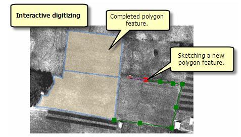
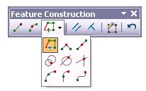
7 Interactive editing ArcGIS Editor toolbar in ArcGIS (practical 1)


8 Manual creation Digitisation Free standing digitiser
9 Manual creation Digitisation How to digitise data of hard copy maps Need to convert paper map to a digital image Scan Photo Georeference; the process of spatially reference an object Vectorise the feature(s) of interest

10 Manual creation Digitisation Hard copy

11 Manual creation Digitisation OS digital basemap

12 Manual creation Digitisation Georeferenced

13 Manual creation Digitisation Digitised route
14 GPS data Original receivers bulky (rucksack carrier) and very expensive Now Trimble, Garmin etc. produce small, hand-held receivers found in; Navigation devices Watches Smartphones More complex ones have data input facilities ArcPad for interactive entry of GPS data in the field

15 Trimble with ArcPad GPS device
16 GPS satellite network Created by the US Department of Defence Originally run using 24 satellites Initially reserved for military use Until 2000 only a degraded signal was available for civilian use (low accuracy ~ 100m) EU Galileo system Russia GLONASS China Beidou navigation system

17 GPS satellite network
18 Satellite trilateration If distance from satellite S is known then somewhere on sphere S
19 Satellite trilateration S With two satellites somewhere on the intersection of two spheres S
20 Satellite trilateration A 3 rd measurement narrows down our position to two points One point can be ignored (it will be in space!). As long as we know the distance from 3 satellites, we can find our position S S S
21 Satellite trilateration S S S S A forth satellite will create an intersection at only one point, and provide clock accuracy
22 Satellite trilateration How do we know distance from satellite? Need to know exact time A pseudorandom signal sent from satellite to receiver Receiver also generates pseudorandom signal Synchronise pseudorandom signals from satellite and receiver and measure the time difference between same part of code Multiply time difference by speed of light to find distance to each satellite
23 Aspatial/Attribute data Usually best entered as a separate process from digitising Only simple ID nos. entered at digitising Raster maps may require different categories to be selected by operator, and identified Large amounts of aspatial data can sometimes be entered in a spreadsheet, before linking with spatial
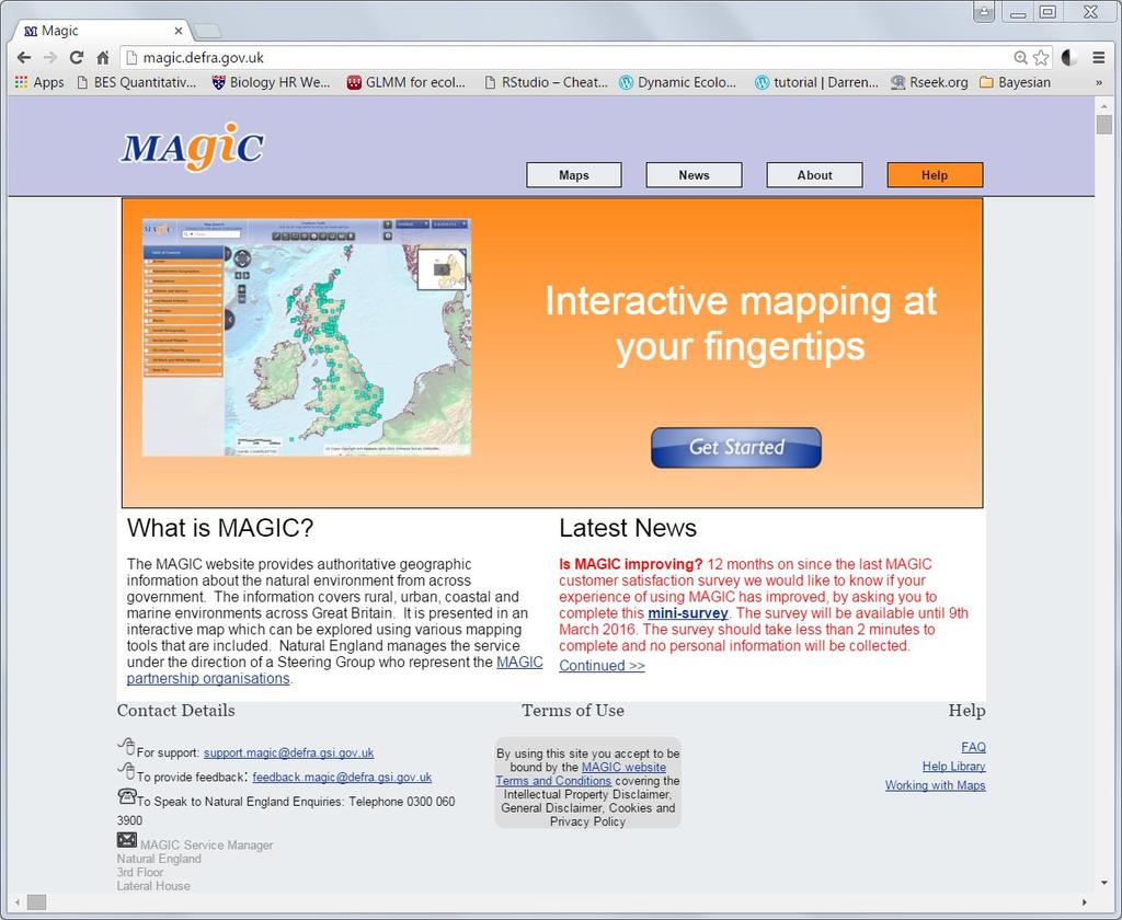
24 Smartphones General ecological \ environmental survey vs civil engineering? GPS positioning in modern iphone (Apple) and Android phones Requires good mobile network coverage. 3G nationwide, 4G improving Can download maps in advance for use in field if reception is poor
25 Fieldtrip GB Produced by Edina (Edinburgh University) for environmental scientists Simple web interface to customise data collection application on smartphone Displays background map Data synchronisation via Dropbox account on smartphone and PC Stores grid coordinates and attribute data (including photos \ audio)

26 Fieldtrip GB

27 Fieldtrip GB
28 General data errors in GIS In brief, spatial data might be incomplete or double in wrong place at wrong scale distorted linked to wrong aspatial data aspatial data wrong or incomplete Remember errors can be propagated through the GIS database if not corrected early
29 Using extant datasets Usually good investment of time and money Many countries (especially USA) put spatial data into the public domain (free) UK academia has reduced cost or zero costs for some GIS data Cost of labour to create one s own usually means commercial datasets less expensive in the long run Some datasets can be downloaded from web, others CD-ROM delivery
30 EDINA UK national academic data centre based at the University of Edinburgh Digimap; Ordnance Survey, geology, historical maps & marine maps UKBORDERS; boundary data for the UK agcensus; agricultural census data ShareGeo Open; spatial data repository to promote data sharing
31 MAGIC Central web-portal for spatial environmental data produce by governmental organisations Providers include; Defra, Environmental Agency, Forestry commission and many others Data includes; SSSI, Ancient woodlands, Local Nature Reserves, etc.
32
33 Commercial suppliers High costs, either added to a given project or supplied by client emapsite is one such supplier OS data Satellite imagery Height data
34 Remote sensed data Very expensive for new data Selected archive data available through Landmap.ac.uk to academic institutions
35 Further data suppliers UK soil data ESRI data US government GIS data portal Fieldtrip GB
36 Summary Data is key and will drive project Creation can be timely Acquisition can be costly You must be able to make an assessment of data quality Spatial accuracy of data for environmental scientists vs civil engineers may allow simpler data collection Websites change rapidly
GLOBAL POSITIONING SYSTEMS
 GLOBAL POSITIONING SYSTEMS GPS & GIS Fall 2017 Global Positioning Systems GPS is a general term for the navigation system consisting of 24-32 satellites orbiting the Earth, broadcasting data that allows
GEOGRAPHIC INFORMATION SYSTEMS Lecture 22: Field Mapping with GPS
 GEOGRAPHIC INFORMATION SYSTEMS Lecture 22: Field Mapping with GPS GPS Receivers - there are many GPS receivers on the market today - some receivers are relatively inexpensive (recreational grade receivers)
36. Global Positioning System
 36. Introduction to the Global Positioning System (GPS) Why do we need GPS? Position: a basic need safe sea travel, crowed skies, resource management, legal questions Positioning: a challenging job local
What is a GPS How does GPS work? GPS Segments GPS P osition Position Position Accuracy Accuracy Accuracy GPS A pplications Applications Applications
 What is GPS? What is a GPS How does GPS work? GPS Segments GPS Position Accuracy GPS Applications What is GPS? The Global Positioning System (GPS) is a precise worldwide radio-navigation system, and consists
ARCGIS DESKTOP DEMO (GEOCODING, SERVICE AREAS, TABULAR & SPATIAL JOINS)
") ARCGIS DESKTOP DEMO (GEOCODING, SERVICE AREAS, TABULAR & SPATIAL JOINS) Indiana State GIS Day Conference: September 22, 2015 ASHLEY SUITER GIS Data Analyst Epidemiology Resource Center Indiana State Department
ARCGIS DESKTOP DEMO (GEOCODING, SERVICE AREAS, TABULAR & SPATIAL JOINS) Indiana State GIS Day Conference: September 22, 2015 ASHLEY SUITER GIS Data Analyst Epidemiology Resource Center Indiana State Department
NR402 GIS Applications in Natural Resources
 NR402 GIS Applications in Natural Resources Lesson 5 GPS/GIS integration Global Positioning System (GPS)..a global navigation system that everyone can use What is GPS? How does it work? How accurate is
The Global Positioning System II Field Experiments. 10/10/2013 GEO327G/386G, UT Austin 5-1
 The Global Positioning System II Field Experiments 10/10/2013 GEO327G/386G, UT Austin 5-1 Mexico DGPS Field Campaign Cenotes in Tamaulipas, MX, near Aldama 10/10/2013 GEO327G/386G, UT Austin 5-2 Are Cenote
GE 113 REMOTE SENSING
 GE 113 REMOTE SENSING Topic 9. Introduction to Global Positioning Systems (GPS) and Other GNSS Technologies Lecturer: Engr. Jojene R. Santillan jrsantillan@carsu.edu.ph Division of Geodetic Engineering
GLOBAL POSITIONING SYSTEMS. Knowing where and when
 GLOBAL POSITIONING SYSTEMS Knowing where and when Overview Continuous position fixes Worldwide coverage Latitude/Longitude/Height Centimeter accuracy Accurate time Feasibility studies begun in 1960 s.
GLOBAL NAVIGATION SATELLITE SYSTEMS (GNSS) ECE 2526E Tuesday, 24 April 2018
 ECE 2526E Tuesday, 24 April 2018") GLOBAL NAVIGATION SATELLITE SYSTEMS (GNSS) ECE 2526E Tuesday, 24 April 2018 MAJOR GLOBAL NAVIGATION SATELLITE SYSTEMS (GNSS) Global Navigation Satellite System (GNSS) includes: 1. Global Position System
GLOBAL NAVIGATION SATELLITE SYSTEMS (GNSS) ECE 2526E Tuesday, 24 April 2018 MAJOR GLOBAL NAVIGATION SATELLITE SYSTEMS (GNSS) Global Navigation Satellite System (GNSS) includes: 1. Global Position System
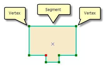
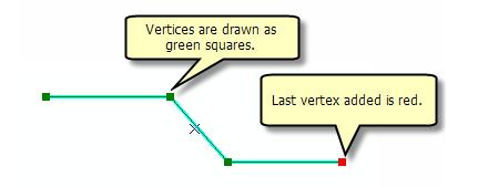
Line and polygon features can be created via on-screen digitizing.
 This module explains how GPS works, sources of error, and error correction using real time or post processing differential correction. Cost and accuracy of different grades of GPS units are also part of
The topic we are going to see in this unit, the global positioning system, is not directly related with the computer networks we use everyday, but it
 The topic we are going to see in this unit, the global positioning system, is not directly related with the computer networks we use everyday, but it is indeed a kind of computer network, as the specialised
Introduction to Total Station and GPS
 Introduction to Total Station and GPS Dr. P. NANJUNDASWAMY Professor of Civil Engineering J S S Science and Technology University S J College of Engineering Mysuru 570 006 Introduction History GPS Overview
Global Positioning Systems (GPS) Trails: the achilles heel of mapping from the air / satellites
 Trails: the achilles heel of mapping from the air / satellites") Global Positioning Systems (GPS) Trails: the achilles heel of mapping from the air / satellites Google maps updated regularly by local users using GPS Also: http://openstreetmaps.org GPS applications
Global Positioning Systems (GPS) Trails: the achilles heel of mapping from the air / satellites Google maps updated regularly by local users using GPS Also: http://openstreetmaps.org GPS applications
Geocoding DoubleCheck: A Unique Location Accuracy Assessment Tool for Parcel-level Geocoding
 Measuring, Modelling and Mapping our Dynamic Home Planet Geocoding DoubleCheck: A Unique Location Accuracy Assessment Tool for Parcel-level Geocoding Page 1 Geocoding is a process of converting an address
Introduction to Geographic Information Science. Last Lecture. Today s Outline. Geography 4103 / GNSS/GPS Technology
 Geography 4103 / 5103 Introduction to Geographic Information Science GNSS/GPS Technology Last Lecture Geoids Ellipsoid Datum Projection Basics Today s Outline GNSS technology How satellite based navigation
UNIGIS University of Salzburg. Module: ArcGIS for Server Lesson: Online Spatial analysis UNIGIS
 1 Upon the completion of this presentation you should be able to: Describe the geoprocessing service capabilities Define supported data types input and output of geoprocessing service Configure a geoprocessing
What is it? History. Other systems. How does it work? Trilateration GEOG 201 4/28/2010. Instructor: Pesses 1. {06} The Global Positioning System
 What is it? {06} The Global Positioning System G.P.S. = Global Positioning System Different from G.I.S. (Geographic Information Systems) Map Interpretation & GPS Spring 2010 M. Pesses History Conceived
Esri UC 2014 Technical Workshop
 Introduction to Parcel Fabric Amir Plans Parcels Control 1 Points 1-1 Line Points - Lines Editing and Maintaining Parcels using Deed Drafter and ArcGIS Desktop What is a parcel fabric? Dataset of related
Global Positioning System (GPS)
") Global Positioning System (GPS) GPS enables users to easily record the location of natural and man-made features on the land. It allows users to identify where a photo or video is taken, revisit previously
Global Positioning System (GPS) GPS enables users to easily record the location of natural and man-made features on the land. It allows users to identify where a photo or video is taken, revisit previously
Sources of Geographic Information
 Sources of Geographic Information Data properties: Spatial data, i.e. data that are associated with geographic locations Data format: digital (analog data for traditional paper maps) Data Inputs: sampled
Lecture 05 Localization & GPS
 CS 460/560 Introduction to Computational Robotics Fall 2017, Rutgers University Lecture 05 Localization & GPS Instructor: Jingjin Yu Outline Basic localization methods Triangulation Trilateration Global
What is GPS? GPS Position Accuracy. GPS Applications. What is a GPS. How does GPS work? GPS Segments
 What is GPS? What is a GPS How does GPS work? GPS Segments GPS Position Accuracy GPS Applications 1 What is GPS? The Global Positioning System (GPS) is a precise worldwide radio-navigation system, and
GPS: What do I need to collect Application Appropriate location data?
 GPS: What do I need to collect Application Appropriate location data? Bob Goodwin, GISP GIS/Remote Sensing Analyst Remote Sensing & GIS Research and Outreach Services, MSU http://www.rsgis.msu.edu 2005
The last 25 years - GPS to multi-gnss: from a military tool to the most widely used civilian positioning solution
 1 The last 25 years - GPS to multi-gnss: from a military tool to the most widely used civilian positioning solution B. Hofmann-Wellenhof Institute of Geodesy / Navigation, Graz University of Technology
ArcGIS Tutorial: Geocoding Addresses
 U ArcGIS Tutorial: Geocoding Addresses Introduction Address data can be applied to a variety of research questions using GIS. Once imported into a GIS, you can spatially display the address locations and
GNSS 101 Bringing It Down To Earth
 GNSS 101 Bringing It Down To Earth Steve Richter Frontier Precision, Inc. UTM County Coordinates NGVD 29 State Plane Datums Scale Factors Projections Session Agenda GNSS History & Basic Theory Coordinate
Using Location-Based Services to Improve Census and Demographic Statistical Data. Deirdre Dalpiaz Bishop May 17, 2012
 Using Location-Based Services to Improve Census and Demographic Statistical Data Deirdre Dalpiaz Bishop May 17, 2012 U.S. Census Bureau Mission To serve as the leading source of quality data about the
GLOBAL POSITIONING SYSTEMS
 GLOBAL POSITIONING SYSTEMS Maps & Geospatial Concepts Fall 2015 Before GPS Historical look at navigation Giant concrete arrows that point your way across America What are these giant arrows? Some kind
FieldGenius Technical Notes GPS Terminology
 FieldGenius Technical Notes GPS Terminology Almanac A set of Keplerian orbital parameters which allow the satellite positions to be predicted into the future. Ambiguity An integer value of the number of
FIELD DATA COLLECTION USING SMART PHONES, TABLETS, AND GPS DEVICES: A CASE STUDY. By Wende Mix & Mary Perrelli SUNY Buffalo State College
 FIELD DATA COLLECTION USING SMART PHONES, TABLETS, AND GPS DEVICES: A CASE STUDY By Wende Mix & Mary Perrelli SUNY Buffalo State College Outline Research Question Methodology Results Summary Research Question
VGIN Geocoding Service
 VGIN Geocoding Service What is Geocoding? Geocoding is the process of assigning geographic coordinates (e.g., latitude and longitude) to data records such as street addresses. With geographic coordinates,
Lecture 8: GIS Data Error & GPS Technology
 Lecture 8: GIS Data Error & GPS Technology A. Introduction We have spent the beginning of this class discussing some basic information regarding GIS technology. Now that you have a grasp of the basic terminology
Resection. We can measure direction in the real world! Lecture 10: Position Determination. Resection Example: Isola, Slovenia. Professor Keith Clarke
 Geography 12: Maps and Spatial Reasoning Lecture 10: Position Determination We can measure direction in the real world! Professor Keith Clarke Resection Resection Example: Isola, Slovenia Back azimuth
APCAS/10/21 April 2010 ASIA AND PACIFIC COMMISSION ON AGRICULTURAL STATISTICS TWENTY-THIRD SESSION. Siem Reap, Cambodia, April 2010
 APCAS/10/21 April 2010 Agenda Item 8 ASIA AND PACIFIC COMMISSION ON AGRICULTURAL STATISTICS TWENTY-THIRD SESSION Siem Reap, Cambodia, 26-30 April 2010 The Use of Remote Sensing for Area Estimation by Robert
Lecture-1 CHAPTER 2 INTRODUCTION TO GPS
 Lecture-1 CHAPTER 2 INTRODUCTION TO GPS 2.1 History of GPS GPS is a global navigation satellite system (GNSS). It is the commonly used acronym of NAVSTAR (NAVigation System with Time And Ranging) GPS (Global
GeoBase Raw Imagery Data Product Specifications. Edition
 GeoBase Raw Imagery 2005-2010 Data Product Specifications Edition 1.0 2009-10-01 Government of Canada Natural Resources Canada Centre for Topographic Information 2144 King Street West, suite 010 Sherbrooke,
The Global Positioning System II Field Experiments
 The Global Positioning System II Field Experiments 5-1 Mexico DGPS Field Campaign Cenotes in Tamaulipas, MX, near Aldama 5-2 Are Cenote Water Levels Related? 5-3 DGPS Static Survey of Cenote Water Levels
ArcGIS Apps and GPS GNSS Connections. By: Colin Lawrence and Kiersten Hudson
 ArcGIS Apps and GPS GNSS Connections By: Colin Lawrence and Kiersten Hudson Agenda ArcGIS Apps and high accuracy data The importance of high accuracy data Making connections to external receivers Bringing
Geoscience & Positioning, Navigation and Timing Services for Canadians
 Geoscience & Positioning, Navigation and Timing Services for Canadians Calvin Klatt, Ph.D. Director and Chief Geodesist Natural Resources Canada / Directeur et géodésien principal Ressources naturelles
Primer on GPS Operations
 MP Rugged Wireless Modem Primer on GPS Operations 2130313 Rev 1.0 Cover illustration by Emma Jantz-Lee (age 11). An Introduction to GPS This primer is intended to provide the foundation for understanding
Principal Investigator Co-Principal Investigator Co-Principal Investigator Prof. Talat Ahmad Vice-Chancellor Jamia Millia Islamia Delhi
 Subject Paper No and Title Module No and Title Module Tag Geology Remote Sensing and GIS Concepts of Global Navigation Satellite RS & GIS XXXIII Principal Investigator Co-Principal Investigator Co-Principal
Satellite image classification
 Satellite image classification EG2234 Earth Observation Image Classification Exercise 29 November & 6 December 2007 Introduction to the practical This practical, which runs over two weeks, is concerned
The 2020 Census Geographic Partnership Opportunities
 The 2020 Census Geographic Partnership Opportunities Web Adams Geographer, U.S. Census Bureau New York Regional Office 1 Geographic Partnership Opportunities The 2020 Census Local Update of Census Addresses
GPS: The Basics. Darrell R. Dean, Jr. Civil and Environmental Engineering West Virginia University. Expected Learning Outcomes for GPS
 GPS: The Basics Darrell R. Dean, Jr. Civil and Environmental Engineering West Virginia University Expected Learning Outcomes for GPS Explain the acronym GPS Name 3 important tdt dates in history of GPS
Realigning Historical Census Tract and County Boundaries
 Realigning Historical Census Tract and County Boundaries David Van Riper Research Fellow Minnesota Population Center University of Minnesota Twin Cities dvanriper@gmail.com Stanley Dallal ESEA dallal@esea.com
The Global Positioning Sytem II 10/19/2017
 The Global Positioning System II Field Experiments 10/19/2017 5-1 Mexico DGPS Field Campaign Cenotes in Tamaulipas, MX, near Aldama 10/19/2017 5-2 Are Cenote Water Levels Related? 10/19/2017 5-3 M. Helper,
King AbdulAziz University. Faculty of Environmental Design. Geomatics Department. Mobile GIS GEOM 427. Lecture 3
 King AbdulAziz University Faculty of Environmental Design Geomatics Department Mobile GIS GEOM 427 Lecture 3 Ahmed Baik, Ph.D. Email: abaik@kau.edu.sa Eng. Fisal Basheeh Email: fbasaheeh@kau.edu.sa GNSS
GPS Apps for Smart Phone and PC YHA Bushwalking Club Night Presentation. Lutz Lademann May 2016
 GPS Apps for Smart Phone and PC YHA Bushwalking Club Night Presentation Lutz Lademann walks@lademann.de May 2016 Content How Does GPS Work What are GPX Files Where to Find GPX Files/Tracks/Walks How to
Street Canyon Tool. User Guide CERC
 Street Canyon Tool User Guide CERC ADMS Street Canyon Tool Version 2.0 User Guide August 2018 Cambridge Environmental Research Consultants Ltd. 3, King s Parade Cambridge CB2 1SJ UK Telephone: +44 (0)1223
ArcGIS 9 Using ArcGIS StreetMap
 ArcGIS 9 Using ArcGIS StreetMap Copyright 2001 2004 ESRI All Rights Reserved. Printed in the United States of America. The information contained in this document is the exclusive property of ESRI. This
Hitchhiker s s Guide Global Position System. Global Position System
 Hitchhiker s s Guide Global Position System Myles Sutherland Craig Greenwald Mike Shaw John Rogers Hitchhiker s s Guide Global Position System (GPS) Myles Sutherland - ESRI Craig Greenwald ESRI John Rogers
White paper brief IdahoView Imagery Services: LISA 1 Technical Report no. 2 Setup and Use Tutorial
 White paper brief IdahoView Imagery Services: LISA 1 Technical Report no. 2 Setup and Use Tutorial Keith T. Weber, GISP, GIS Director, Idaho State University, 921 S. 8th Ave., stop 8104, Pocatello, ID
Chapter 2 Outdoor Navigation
 Chapter 2 Outdoor Navigation 2.1 Introduction In this chapter, the technologies and techniques that are employed in outdoor navigation systems/services along with their features and users are discussed.
Methodologies and IT-tools for managing and monitoring field work using geo-spatial tools and other IT- Tools for monitoring
 Methodologies and IT-tools for managing and monitoring field work using geo-spatial tools and other IT- Tools for monitoring Janusz Dygaszewicz Central Statistical Office of Poland Jerusalem, 11-14 July
Closing the Data Collection Circle. Stephen Osiecki GIS Manager VHB, Inc. Orlando, FL
 Closing the Data Collection Circle Stephen Osiecki GIS Manager VHB, Inc. Orlando, FL Traditional Data Collection Method Bulky Land use maps Photographs Draw features on paper maps Collect attribute information
Research Article Fast Comparison of High-Precision Time Scales Using GNSS Receivers
 Hindawi International Navigation and Observation Volume 2017, Article ID 9176174, 4 pages https://doi.org/10.1155/2017/9176174 Research Article Fast Comparison of High-Precision Time Scales Using Receivers
European GNSS Evolution
 Ref. Ares(204)902599 - /06/204 European GNSS Evolution Hermann Ebner Galileo and EGNOS Programme Management DG Enterprise and Industry Content Introduction 2 2 Major Challenges for EGNSS Evolution 3 EGNSS
The Mid-term Review of the European Satellite Radio Navigation Programmes Galileo and EGNOS: Questions and Answers
 MEMO/11/26 Brussels, 18 th January 2011 The Mid-term Review of the European Satellite Radio Navigation Programmes Galileo and EGNOS: Questions and Answers See also IP/11/42 For the full text of the Communication
9 October Opportunities to Promote Data Sharing UCL and the YODA Project. Emma White. Associate Director
 9 October 2015 Opportunities to Promote Data Sharing UCL and the YODA Project Emma White Associate Director Overview - Administrative Data Research Network (ADRN) - Administrative Data Research Centre
The Global Positioning System
 The Global Positioning System 5-1 US GPS Facts of Note DoD navigation system First launch on 22 Feb 1978, fully operational in 1994 ~$15 billion (?) invested to date 24 (+/-) Earth-orbiting satellites
Performance Evaluation of Differential Global Navigation Satellite System with RTK Corrections
 IOSR Journal of Electronics and Communication Engineering (IOSR-JECE) e-issn: 2278-2834,p- ISSN: 2278-8735.Volume 9, Issue 2, Ver. VI (Mar - Apr. 2014), PP 43-47 Performance Evaluation of Differential
Building Java Apps with ArcGIS Runtime SDK
 Building Java Apps with ArcGIS Runtime SDK Vijay Gandhi, Elise Acheson, Eric Bader Demo Source code: https://github.com/esri/arcgis-runtime-samples-java/tree/master/devsummit-2014 Video Recording: http://video.esri.com
Analysis & Geoprocessing: Case Studies Problem Solving
 Analysis & Geoprocessing: Case Studies Problem Solving Shawn Marie Simpson Federal User Conference 2008 3 Overview Analysis & Geoprocessing Review What is it? How can I use it to answer questions? Case
Understanding GPS: Principles and Applications Second Edition
 Understanding GPS: Principles and Applications Second Edition Elliott Kaplan and Christopher Hegarty ISBN 1-58053-894-0 Approx. 680 pages Navtech Part #1024 This thoroughly updated second edition of an
Flood modelling and management. Glasgow University. 8 September Paul Shaw - GeoVision
 Flood modelling and management Glasgow University 8 September 2004 Paul Shaw - GeoVision How important are heights in flood modelling? Comparison of data collection technologies GPS - Global Positioning
Methods for Mapping Stormwater Infrastructure
 Methods for Mapping Stormwater Infrastructure GIS Day 2018 Rebecca Talamini Applied Geographics Project Manager Rebecca Talamini Project Manager - AppGeo rtalamini@appgeo.com 860-339-4255 Who is? Boston
Lesson 3: Working with Landsat Data
 Lesson 3: Working with Landsat Data Lesson Description The Landsat Program is the longest-running and most extensive collection of satellite imagery for Earth. These datasets are global in scale, continuously
GPS Milestones, cont. GPS Milestones. The Global Positioning Sytem, Part 1 10/10/2017. M. Helper, GEO 327G/386G, UT Austin 1. US GPS Facts of Note
 The Global Positioning System US GPS Facts of Note DoD navigation system First launch on 22 Feb 1978, fully operational in 1994 ~$15 billion (?) invested to date 24 (+/-) Earth-orbiting satellites (SVs)
Introduction to the Global Positioning System
 GPS for Fire Management - 2004 Introduction to the Global Positioning System Pre-Work Pre-Work Objectives Describe at least three sources of GPS signal error, and identify ways to mitigate or reduce those
What makes the positioning infrastructure work. Simon Kwok Chairman, Land Surveying Division Hong Kong Institute of Surveyors
 What makes the positioning infrastructure work The experience of the Hong Kong Satellite Positioning Reference Station Network Simon Kwok Chairman, Land Surveying Division Hong Kong Institute of Surveyors
Geocoding and Address Matching
 LAB PREP: Geocoding and Address Matching Environmental, Earth, & Ocean Science 381 -Spring 2015 - Geocoding The process by which spatial locations are determined using coordinate locations specified in
Sarah Steele, Curriculum Materials/Media Librarian, Campbell University Karen Waller, Media Specialist, Timber Drive Elementary School
 Sarah Steele, Curriculum Materials/Media Librarian, Campbell University Karen Waller, Media Specialist, Timber Drive Elementary School These are a group of 24 satellites started in 1978 by the US Navy
A Step-by-Step Guide to: for Andriod Devices
 A Step-by-Step Guide to: for Andriod Devices Contents Registration, Rules of the Game, Timeline, Downloading Collector... 1 Opening Collector..... 2 Collector Basics..... 3 Toolbar... 3 Game Play... 4
Generating Virtual Environments by Linking Spatial Data Processing with a Gaming Engine
 Generating Virtual Environments by Linking Spatial Data Processing with a Gaming Engine Christian STOCK, Ian D. BISHOP, and Alice O CONNOR 1 Introduction As the general public gets increasingly involved
Environmental Noise Mapping with Smartphone Applications: A participatory noise map of West Hartford, CT.
 Providence, RI NOISE-CON 2016 2016 June 13-15 : A participatory noise map of West Hartford, CT. Christopher Springthorpe Enda Murphy Lane Miller School of Architecture, Planning & Environmental Policy
GPS Technical Overview N5TWP NOV08. How Can GPS Mislead
 GPS Technical Overview How Can GPS Mislead 1 Objectives Components of GPS Satellite Acquisition Process Position Determination How can GPS Mislead 2 Components of GPS Control Segment Series of monitoring
Attribution and impact for social science data
 Attribution and impact for social science data Louise Corti Collections Development and Producer Support ODIN conference, Cologne October 2013 Overview Introducing the UK Data Service Our data portfolio
ArcGIS Runtime SDK for Java: Building Applications. Eric
 ArcGIS Runtime SDK for Java: Building Applications Eric Bader @ECBader Agenda ArcGIS Runtime and the SDK for Java How to build / Functionality - Maps, Layers and Visualization - Geometry Engine - Routing
Is neo-cadastral surveying on your smartphone feasible?
 Is neo-cadastral surveying on your smartphone feasible? School of Civil & Environmental Engineering Craig Roberts UNSW Paul Davis-Raiss, David Lofberg, Greg Goodman LandTeam Van der Vlugt, 2012 1 Cadastral
An ESRI White Paper May 2009 ArcGIS 9.3 Geocoding Technology
 An ESRI White Paper May 2009 ArcGIS 9.3 Geocoding Technology ESRI 380 New York St., Redlands, CA 92373-8100 USA TEL 909-793-2853 FAX 909-793-5953 E-MAIL info@esri.com WEB www.esri.com Copyright 2009 ESRI
RESPONSE TO THE HOUSE OF COMMONS TRANSPORT SELECT COMMITTEE INQUIRY INTO GALILEO. Memorandum submitted by The Royal Academy of Engineering
 RESPONSE TO THE HOUSE OF COMMONS TRANSPORT SELECT COMMITTEE INQUIRY INTO GALILEO Memorandum submitted by The Royal Academy of Engineering September 2004 Executive Summary The Royal Academy of Engineering
Qt Developing ArcGIS Runtime Applications. Eric
 Qt Developing ArcGIS Runtime Applications Eric Bader @ECBader Agenda Getting Started Creating the Map Geocoding and Routing Geoprocessing Message Processing Working Offline The Next Release What s Coming
Copyright The McGraw-Hill Companies, Inc. Permission required for reproduction or display.
 Chapter 16. GEOCODING AND DYNAMIC SEGMENTATION 16.1 Geocoding 16.1.1 Geocoding Reference Database 16.1.2 The Address Matching Process 16.1.3 Address Matching Options Box 16.1 Scoring System for Geocoding
Galileo. Opportunities and Challenges by Gard Ueland. November 22, 2011, Brussels. Secure World Foundation Conference. Chairman Galileo Services
 Galileo Opportunities and Challenges by Gard Ueland Chairman Galileo Services Secure World Foundation Conference The Brussels Space Policy Round Table - Galileo November 22, 2011, Brussels Galileo Launch
The GPS Classroom. Jared Covili
 The GPS Classroom Jared Covili 1/17/06 2 The GPS Classroom Jared Covili jcovili@media.utah.edu (801) 585-5667 The GPS Classroom is a 2-day course that provides participants with the basic knowledge of
GPCD Calculations. Process Steps for SAWS Calculation
 GPCD Calculations Process Steps for SAWS Calculation Introduction GPCD refers to the number of gallons produced for sale or use, per person (capita), per day for a utility. GPCD can also be calculated
Public or Private (2)
") // Public or Private () CCST90 Mar, 0 Dr. Hayden Kwok-Hay So Department of Electrical and Electronic Engineering The Making of Google Street View Google Street View Systematically capture photos of the
// Public or Private () CCST90 Mar, 0 Dr. Hayden Kwok-Hay So Department of Electrical and Electronic Engineering The Making of Google Street View Google Street View Systematically capture photos of the
Applied Mobile GIS for Investigation of Arizona Surface Water Rights
 Applied Mobile GIS for Investigation of Arizona Surface Water Rights Andy Fisher and Karen Martini ABSTRACT Since the 1980s, the Arizona Department of Water Resources (ADWR) has served as technical advisor
GBAS FOR ATCO. June 2017
 GBAS FOR ATCO June 2017 Disclaimer This presentation is for information purposes only. It should not be relied on as the sole source of information, and should always be used in the context of other authoritative
GPS Tutorial Trimble Home > GPS Tutorial > How GPS works? > Triangulating
 http://www.trimble.com/gps/howgps-triangulating.shtml Page 1 of 3 Trimble Worldwide Popula PRODUCTS & SOLUTIONS SUPPORT & TRAINING ABOUT TRIMBLE INVESTORS GPS Tutorial Trimble Home > GPS Tutorial > How
Choosing the best path:
 GEODESY Choosing the best path: Global to national coordinate transformations The paper demonstrates that differences of up to a few centimetres in each coordinate component can occur depending on the
The European Satellite Radio Navigation Programmes Galileo and EGNOS: Questions and Answers
 MEMO/11/326 Brussels, 23 May 2011 The European Satellite Radio Navigation Programmes Galileo and EGNOS: Questions and Answers What is satellite navigation? Satellite navigation is based on the principle
Trimble GNSS Infrastructure
 Trimble GNSS Infrastructure A History of Innovation Trimble, the first company to offer commercial GPS products company to integrate GPS with communications technology RTK system in the market in 1994
QGIS document from the previous exercise: worldmap.qgs
 MAP PROJECTION 1. Introduction: All data in a GIS view must be in the same projection in order to correctly align with other datasets. In QGIS this is often done in the background. QGIS will use the projection
The GNSS Subsystem. Johan Hovold. Open Source Summit Europe, Edinburgh October 24, Hovold Consulting AB
 The GNSS Subsystem Johan Hovold Hovold Consulting AB Open Source Summit Europe, Edinburgh October 24, 2018 Introduction Global Navigation Satellite System (GNSS) GPS (US) GLONASS (Russia) BeiDou (China)
Technology Talk Bulletin
 Technology Talk Bulletin This Technology Talk Bulletin compares John Deere dealer s current Real Time Kinematic (RTK) base station approach to the different RTK technologies available. What is RTK? RTK
How to put the Image Services in the Living Atlas to Work in Your GIS. Charlie Frye, Chief Cartographer Esri, Redlands
 How to put the Image Services in the Living Atlas to Work in Your GIS Charlie Frye, Chief Cartographer Esri, Redlands Image Services in the Living Atlas of the World Let s have a look: https://livingatlas.arcgis.com
GNSS Low-Cost High-Accuracy Receiver (L-CHAR)
") GNSS Low-Cost High-Accuracy Receiver (L-CHAR) Dinesh Manandhar Center for Spatial Information Science The University of Tokyo Contact Information: dinesh@iis.u-tokyo.ac.jp Slide : 1 High Accuracy Receivers
GNSS Low-Cost High-Accuracy Receiver (L-CHAR) Dinesh Manandhar Center for Spatial Information Science The University of Tokyo Contact Information: dinesh@iis.u-tokyo.ac.jp Slide : 1 High Accuracy Receivers
SERVIR: The Portuguese Army CORS Network for RTK
 SERVIR: The Portuguese Army CORS Network for RTK António Jaime Gago AFONSO, Rui Francisco da Silva TEODORO and Virgílio Brito MENDES, Portugal Key words: GNSS, RTK, VRS, Network ABSTRACT Traditionally