ArcGIS Apps and GPS GNSS Connections. By: Colin Lawrence and Kiersten Hudson
|
|
|
- Rolf Bruce
- 5 years ago
- Views:
Transcription


1 ArcGIS Apps and GPS GNSS Connections By: Colin Lawrence and Kiersten Hudson
2 Agenda ArcGIS Apps and high accuracy data The importance of high accuracy data Making connections to external receivers Bringing it all together in Collector The importance of GNSS Metadata Common troubleshooting Future Developments


3 The importance of high accuracy data Improve existing data Modernize field workflows Precise field data collection Less post collection cleanup Project requirements - State or Local government projects may require: - Sub-meter accuracy for all points collected - 95% confidence interval - All spatial data collected in NAD83 datum
4 Choosing your Receiver A wide selection of GPS receivers on today s market Receiver must support the output of NMEA sentences Most are supported with Android and Windows; ios is more restrictive Vary in cost, complexity, and accuracy levels


5 Examples of 3rd Party Applications GNSS Status (Trimble) EOS Tools Pro (Arrow) Bad Elf GPS Utility (Bad Elf)

6 Making Connections to External Receivers Install 3rd party app Pair with receiver Configure receiver in 3rd party app


7 Bringing it all Together in Collector Launch Collector Set receiver as Location Provider Open map to verify location
8 Configuring your External Receiver for use in Collector

9
10 Adding and Understanding GNSS Metadata Why is GNSS Metadata important? Adding the GNSS Metadata fields Situations for populating certain fields Using the Metadata to troubleshoot data collection issues Capturing altitude values


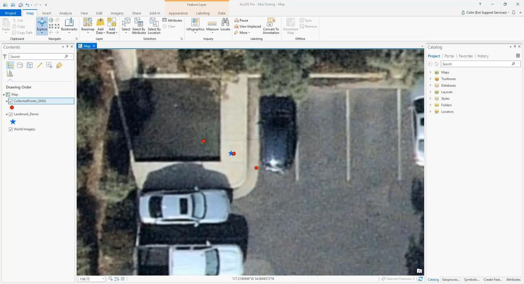
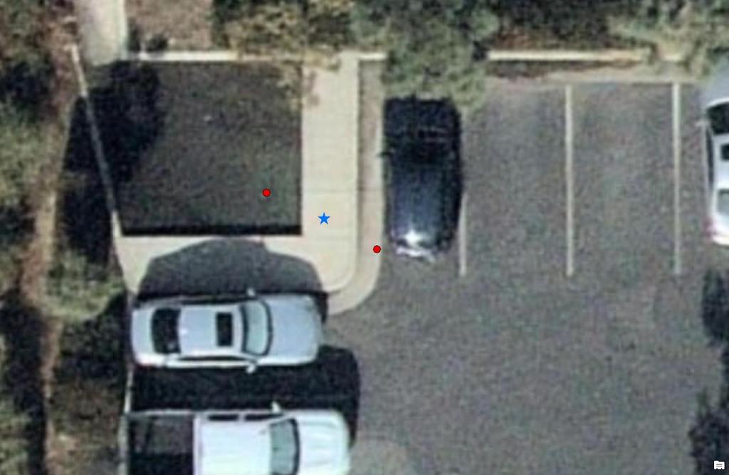
11 Common Troubleshooting My data is not as accurate as I expected I am not getting a position My position is moving, but I am not My accuracy reading differs between Collector & 3 rd party app Try it now GNSS Capture Web Map My data is offset or appearing in the wrong location Required location accuracy Check GNSS Metadata Go outside Avoid buildings and trees Give device more time Verify position in other software Remember this follows the receiver and not your device Your position will adjust over time Check confidence interval setting in Collector Switching between apps takes time Removes your data and Web Map from the equation Testing GNSS Metadata field population Verify with a NGS landmark Check Location Profile, especially if using corrections
12 Troubleshooting Offset Data

13
14 Other Applications Navigator Collector Workforce Survey123 (Aurora for for ArcGIS Release) Non-professional Currently High Supports Accuracy in the beta use workflows with grade of high a full receivers accuracy can release be utilized can receivers. coming be by used in App However, Q3 for Integration of navigation there with and is no user nonauthoritative Direct Collector interface support that Survey123 can for data z-values be used collection to within configure activities Feature the Classes receiver will in Survey123. be added. Subsequently, the GNSS metadata cannot be extracted and there may be limitations with how accuracy is displayed.
15 Other Applications Survey123 for ArcGIS - Supports the use of high accuracy receivers. However, there is no user interface that can be used to configure the receiver in Survey123. Subsequently, the GNSS metadata cannot be extracted and there may be limitations with how accuracy is displayed. Workforce for ArcGIS - High Accuracy workflows can be utilized by App Integration with Collector or Survey123 Navigator for ArcGIS - Non-professional grade receivers can be used for navigation and nonauthoritative data collection activities Collector (Aurora Release) - Currently in beta with a full release coming in Q3 of Direct support for z-values within Feature Classes will be added.
16 Key Takeaways - Importance of high accuracy data - Guidelines for choosing and configuring your external receiver with Collector - The role of GNSS Metadata - Key troubleshooting approaches and examples
17 Questions?

18 Please Take Our Survey on the App Download the Esri Events app and find your event Select the session you attended Scroll down to find the feedback section Complete answers and select Submit


19 Please Take Our Survey on the App Download the Esri Events app and find your event Select the session you attended Scroll down to find the feedback section Complete answers and select Submit
20 Helpful abbreviations - GPS = Global Positioning System - GNSS = Global Navigation Satellite System - RTK = Real Time Kinematic (real time corrections) - NMEA = Nation Marine Electronics Association

21 Accuracy vs Precision The term GPS accuracy is a rather over-used term. However it can be said that the levels of GPS accuracy are extremely high these days, even for civilian use GPS units. It is also worth defining the difference between accuracy and precision: GPS accuracy - The accuracy refers to the degree of closeness the indicated readings are to the actual position. GPS precision - Is the degree to which the readings can be made. The smaller the circle of unknown the higher the precision.

22 Selecting a receiver Ensure the device supports the output of NMEA 0183 sentances See other requirements and a list of tested receivers here:
23 Making Connections to external receivers: Trimble R1 Install the GNSS status app to the device Turn on the external receiver and switch to pairing mode Pair the GNSS device with the phone/tablet using Bluetooth GNSS Status app (3 rd party app) - Check for error messages and lights while pairing Take the devices outside. Working with the GNSS Status app: - Home Screen. Shows a question mark if a GNSS signal is not being picked up. - It shows the accuracy of the signal (metrics vs. USA can be changed in App Settings. It shows the battery power of the device. - Detailed Status. This is filled out when a GNSS signal is received. - Real-time Config. Uncorrected is the Default. Please refer to device instructions and base station for configuring real time corrections

24 Bringing it all together in Collector 1. Once the phone or tablet is communicating successfully with the device, it can be configured in Collector. 2. Configuring Collector to use the external GPS device -Follow the directions outlined in the Collector documentation here:
25 Common Troubleshooting Use GNSS Metadata to gather info regarding receiver, fix type, and accuracy - Try It now account before logging into Collector Initial setup: - Go outdoors to an open area, away from tall buildings and trees. Acquiring satellite signals may take several minutes or more on a cold start of the device - Verify position in other software Remember your location follows the external receiver, not your phone/device Accuracy readings different in Collector vs 3 rd party app - Check confidence interval setting in Collector: - Accuracy readings may appear worse in Collector if using 95% confidence interval
26 Common Troubleshooting cont. Known issues: - Workflow BUG After selecting the Trimble R2 on Collector for ArcGIS (ios) as the location provider, then setting the location profile, the location may not display until Collector is force closed, then GNSS Status Utility is reopened before Collector. - When using RTK on Android with Eos Pro tools - Both Collector and Eos Tools Pro cannot connect to the receiver at the same time. TIP: If using RTK, set a required accuracy in Collector so it will not collect data if you lose this connection and drop to SBAS, etc. Troubleshooting offsets in data collected: RTK and Location profiles
27 Datum Transformations: For reference when setting up a Location Profile DT1 - Web Layers to Geodatabase Feature layers The web map has a coordinate system that is defined by the basemap that you use. ArcGIS Online basemaps use the Web Mercator coordinate system and reference WGS84. You can use your own base maps which reference other coordinate systems, but this must be taken into consideration DT2 - Web Map to Web Layer (Feature Service) When Collector synchronizes edits it checks the coordinate system of the feature service layer and the web map and if required will project GIS features into the coordinate system defined within the feature service. All feature service layers may not have the same coordinate system as it is not required but good practice to do so. DT3 - Web Layers to Geodatabase Feature Layers The feature service coordinate system is set by the coordinate system of the active data frame in ArcMap when it is published. This may be different than the coordinate system of the geodatabase
28 Issues connecting to a receiver - Ensure device is configured to capture NMEA sentences - For Windows only: Collector is a UWP (universal windows platform) application and cannot access a COM or serial port directly. You will need to install a third party application to work around this that maps these communications to a Windows GPS Sensor (location sensor) for Windows applications to be GPS sensor-aware. GPS direct is an example of this type of software.
QUICKSTART
 QUICKSTART WWW.SXBLUEGPS.COM 1 INDEX START-UP PROCEDURE 6-7 ios 4-5 Android 8-9 Windows 10 10-11 Windows Mobile GETTING STARTED WITH 12-13 FieldGenius 14-15 ArcGIS Collector INFO@SXBLUEGPS.COM 514-354-2511
How to put the Image Services in the Living Atlas to Work in Your GIS. Charlie Frye, Chief Cartographer Esri, Redlands
 How to put the Image Services in the Living Atlas to Work in Your GIS Charlie Frye, Chief Cartographer Esri, Redlands Image Services in the Living Atlas of the World Let s have a look: https://livingatlas.arcgis.com
Packaging Projects, Maps and Layers. Shilpi Jain Melanie Summers
 Packaging Projects, Maps and Layers Shilpi Jain Melanie Summers What can be packaged Layer Map Project Layer package (.lypkx) Tile package (.tpk) Scene layer package (.slpk) Map package (.mpkx) Mobile
Upgrading Common Workflows from 10.2.x to 100.x with ArcGIS Runtime SDK for.net. Melanie Whalen & Lauren Boyd
 Upgrading Common Workflows from 10.2.x to 100.x with ArcGIS Runtime SDK for.net Melanie Whalen & Lauren Boyd Agenda Architectural Overview Maps Editing Analysis Resources Q&A Architectural Overview Architecture:
AGENDA. NEI Overview. Mobile platforms with the new R1 / R2 GNSS receiver. High Accuracy Cloud Based Data Collection. Geo 7X Higher Accuracy Option
 AGENDA NEI Overview Mobile platforms with the new R1 / R2 GNSS receiver High Accuracy Cloud Based Data Collection Geo 7X Higher Accuracy Option Selecting - the Right Tool for the Right Job Field to Finish.
All you wanted to know about High Accuracy Data Collection Eric Muncy Precision Products Mapping-GIS Division
 All you wanted to know about High Accuracy Data Collection Eric Muncy Precision Products Mapping-GIS Division Tell me your name What School / Organization Any experience with GPS equipment What would you
GEOGRAPHIC INFORMATION SYSTEMS Lecture 22: Field Mapping with GPS
 GEOGRAPHIC INFORMATION SYSTEMS Lecture 22: Field Mapping with GPS GPS Receivers - there are many GPS receivers on the market today - some receivers are relatively inexpensive (recreational grade receivers)
GPS Pathfinder Office Software or GPS Analyst Extension for ESRI ArcGIS Software: Resolving the NAD 83 Datum Transformation Issue
 13 June 2011 GPS Pathfinder Office Software or GPS Analyst Extension for ESRI ArcGIS Software: Resolving the NAD 83 Datum Transformation Issue Summary The current realizations of the North American Datum
The Global Positioning System II Field Experiments. 10/10/2013 GEO327G/386G, UT Austin 5-1
 The Global Positioning System II Field Experiments 10/10/2013 GEO327G/386G, UT Austin 5-1 Mexico DGPS Field Campaign Cenotes in Tamaulipas, MX, near Aldama 10/10/2013 GEO327G/386G, UT Austin 5-2 Are Cenote
NJDEP GPS Data Collection Standards for GIS Data Development
 NJDEP GPS Data Collection Standards for GIS Data Development Bureau of Geographic Information Systems Office of Information Resource Management April 24 th, 2017 Table of Contents 1.0 Introduction... 3
TDS Survey Pro CE Version Setup RTK Base on known NAD83/WGS84 Point: Mapping Plane Geoid99 Modeling.
 TDS Survey Pro CE Version 2.1.8 Setup RTK Base on known NAD83/WGS84 Point: Mapping Plane Geoid99 Modeling. Pre-load known NAD83 State Plane Coordinates and appropriate NGS Geoid 99/96 data files into the
GPS Pathfinder Office Software or the GPS Analyst Extension for ESRI ArcGIS Software: Resolving the NAD 83 Datum Transformation Issue
 Mapping & GIS Support Note 5 May 2005 GPS Pathfinder Office Software or the GPS Analyst Extension for ESRI ArcGIS Software: Resolving the NAD 83 Datum Transformation Issue Summary The current realizations
MEASURE Evaluation. Global Positioning System Toolkit
 Global Positioning System Toolkit Global Positioning System Toolkit This tool was made possible by support from the U.S. Agency for International Development (USAID) under terms of Cooperative Agreement
TDS Ranger Survey Pro CE Version RTK Base on known Control Point. RTK Rover - Localization with Control Points.
 TDS Ranger Survey Pro CE Version 2.1.8 RTK Base on known Control Point. RTK Rover - Localization with Control Points. Pre-load control Coordinates and appropriate NGS Geoid 99/96 data files into the Ranger
ArcGIS Pro: Tips & Tricks
 ArcGIS Pro: Tips & Tricks James Sullivan Solution Engineer Agenda Project Structure/Set Up Data Visualization/Map Authoring Data/Map Exploration Geoprocessing Editing Layouts Sharing Working with the Ribbon
Utilizing A GNSS Network Solution for Utility Applications
 Utilizing A GNSS Network Solution for Utility Applications David Newcomer, PE, PLS GPServ, Inc. newcomer@ (407) 601-5816 AGENDA Types and accuracies of data collection o Autonomous o Meter + o Sub-meter
Working with Elevation Services. Cody Benkelman
 Working with Elevation Services Cody Benkelman Outline ArcGIS Online World Elevation & 3D Elevation Cache for Pro What is included? - Data and Tools How can I use it? - Modes of use - Client Applications
Introduction to Total Station and GPS
 Introduction to Total Station and GPS Dr. P. NANJUNDASWAMY Professor of Civil Engineering J S S Science and Technology University S J College of Engineering Mysuru 570 006 Introduction History GPS Overview
GNSS Low-Cost High-Accuracy Receiver (L-CHAR)
") GNSS Low-Cost High-Accuracy Receiver (L-CHAR) Dinesh Manandhar Center for Spatial Information Science The University of Tokyo Contact Information: dinesh@iis.u-tokyo.ac.jp Slide : 1 High Accuracy Receivers
GNSS Low-Cost High-Accuracy Receiver (L-CHAR) Dinesh Manandhar Center for Spatial Information Science The University of Tokyo Contact Information: dinesh@iis.u-tokyo.ac.jp Slide : 1 High Accuracy Receivers
Table of Contents GPS
 Table of Contents GPS 6000...1 Q: Is the GPS 6000 compatible with the RTK Relay Module?...1 What is GLIDE?...2 What is StableLocâ?...3 GPS 6000/GPS 6500/GPS 6500 Relay Mounting Bracket Explainer...4 GPS
EDUCATION GIS CONFERENCE Geoprocessing with ArcGIS Pro. Rudy Prosser GISP CTT+ Instructor, Esri
 EDUCATION GIS CONFERENCE Geoprocessing with ArcGIS Pro Rudy Prosser GISP CTT+ Instructor, Esri Maintenance What is geoprocessing? Geoprocessing is - a framework and set of tools for processing geographic
The Global Positioning System
 The Global Positioning System 5-1 US GPS Facts of Note DoD navigation system First launch on 22 Feb 1978, fully operational in 1994 ~$15 billion (?) invested to date 24 (+/-) Earth-orbiting satellites
Best field practices for GIS Data collection: Presented by, Jacob Wittenberg Frontier Precision, Inc.
 Best field practices for GIS Data collection: Presented by, Jacob Wittenberg Frontier Precision, Inc. Agenda What is GNSS Code and Carrier Data H-Star Processing Best Practices Code and Carrier Solutions
GPS Milestones, cont. GPS Milestones. The Global Positioning Sytem, Part 1 10/10/2017. M. Helper, GEO 327G/386G, UT Austin 1. US GPS Facts of Note
 The Global Positioning System US GPS Facts of Note DoD navigation system First launch on 22 Feb 1978, fully operational in 1994 ~$15 billion (?) invested to date 24 (+/-) Earth-orbiting satellites (SVs)
GPS: The Basics. Darrell R. Dean, Jr. Civil and Environmental Engineering West Virginia University. Expected Learning Outcomes for GPS
 GPS: The Basics Darrell R. Dean, Jr. Civil and Environmental Engineering West Virginia University Expected Learning Outcomes for GPS Explain the acronym GPS Name 3 important tdt dates in history of GPS
Real-time Water Vapor and TEC calculation using existing GNSS reference station infrastructure. Rana Charara Trimble Infrastructure
 Real-time Water Vapor and TEC calculation using existing GNSS reference station infrastructure Rana Charara Trimble Infrastructure GNSS Netwoks International GNSS Network and Meteorological Products IGS
Building Java Apps with ArcGIS Runtime SDK
 Building Java Apps with ArcGIS Runtime SDK Vijay Gandhi, Elise Acheson, Eric Bader Demo Source code: https://github.com/esri/arcgis-runtime-samples-java/tree/master/devsummit-2014 Video Recording: http://video.esri.com
Quick Start. Precis-BX305. Precise GNSS RTK Board.
 Quick Start Precis-BX305 Precise GNSS RTK Board www.tersus-gnss.com December, 2016 Quick Start Guide of Precis-BX305 This quick start guide provides the basic information needed to set up and use Precis-BX305
IMO WORLDWIDE RADIONAVIGATION SYSTEM (WWRNS) Study on Communication Techniques for High Accuracy DGPS in the Republic of Korea
 Study on Communication Techniques for High Accuracy DGPS in the Republic of Korea") INTERNATIONAL MARITIME ORGANIZATION E IMO SUB-COMMITTEE ON SAFETY OF NAVIGATION 52nd session Agenda item 12 NAV 52/INF.8 12 May 2006 ENGLISH ONLY WORLDWIDE RADIONAVIGATION SYSTEM (WWRNS) Study on Communication
INTERNATIONAL MARITIME ORGANIZATION E IMO SUB-COMMITTEE ON SAFETY OF NAVIGATION 52nd session Agenda item 12 NAV 52/INF.8 12 May 2006 ENGLISH ONLY WORLDWIDE RADIONAVIGATION SYSTEM (WWRNS) Study on Communication
GPS Search for Advanced Total Station Operation
 GPS Search for Advanced Total Station Operation Tim LEMMON, Australia, and, Chris VAN DER LOO, New Zealand Key words: GPS, Robotic total stations, integrated solutions. SUMMARY The Global Positioning System
ExpoM - ELF User Manual
 ExpoM - ELF User Manual Version 1.4 ExpoM - ELF User Manual Contents 1 Description... 4 2 Case and Interfaces... 4 2.1 Overview... 4 2.2 Multi-color LED... 5 3 Using ExpoM - ELF... 6 3.1 Starting a Measurement...
Performance Evaluation of Differential Global Navigation Satellite System with RTK Corrections
 IOSR Journal of Electronics and Communication Engineering (IOSR-JECE) e-issn: 2278-2834,p- ISSN: 2278-8735.Volume 9, Issue 2, Ver. VI (Mar - Apr. 2014), PP 43-47 Performance Evaluation of Differential
TEST YOUR SATELLITE NAVIGATION PERFORMANCE ON YOUR ANDROID DEVICE GLOSSARY
 TEST YOUR SATELLITE NAVIGATION PERFORMANCE ON YOUR ANDROID DEVICE GLOSSARY THE GLOSSARY This glossary aims to clarify and explain the acronyms used in GNSS and satellite navigation performance testing
GLOBAL POSITIONING SYSTEMS
 GLOBAL POSITIONING SYSTEMS GPS & GIS Fall 2017 Global Positioning Systems GPS is a general term for the navigation system consisting of 24-32 satellites orbiting the Earth, broadcasting data that allows
SPECTRACOM ecall Compliance Tool
 SPECTRACOM ecall GSG SIMULATOR configuration PROVIDED BY SPECTRACOM for ecall GNSS DEVICE TESTING European Standard regulation for ecall (ANNEX VI GNSS testing) Spectracom solution provides GSG simulators
Managing Imagery and Raster Data. Peter Becker
 Managing Imagery and Raster Data Peter Becker ArcGIS is a Comprehensive Imagery Platform Empowering you to make informed decisions System of Engagement System of Insight Extract Information from Imagery
Appendix D Brief GPS Overview
 Appendix D Brief GPS Overview Global Positioning System (GPS) Theory What is GPS? The Global Positioning System (GPS) is a satellite-based navigation system, providing position information, accurate to
Advanced Least Squares Adjustments for Post Processed GPS
 Advanced Least Squares Adjustments for Post Processed GPS 2018 Fall Conference October 18, 2018 College park, Maryland Instructor: Maser Consulting PA Independent Baselines The observations for GPS receivers
GNSS Technology Update
 GNSS Technology Update Speaker: Eric Gakstatter Contributing Editor GPS World Editor - Geospatial Solutions Presented at: Association of Petroleum Surveying & Geomatics Houston, TX April 7, 2015 Agenda
USER MANUAL FIELDBEE AND RTK BEE STATION FULL VERSION. WE PROVIDE ONLINE SUPPORT: VERSION 1.0.
 USER MANUAL FULL VERSION VERSION 1.0. FIELDBEE AND RTK BEE STATION WE PROVIDE ONLINE SUPPORT: support@efarmer.mobi info@efarmer.mobi CONTENTS TABLE OF CONTENTS INTRODUCTION... 3 3 WAYS OF USING FIELDBEE...
GPS Pathfinder ProXH and ProXT Customer FAQs
 7 December 2009 GPS Pathfinder ProXH and ProXT Customer FAQs What is the GPS Pathfinder ProXH receiver? The GPS Pathfinder ProXH receiver is a fully integrated receiver, antenna and battery unit with Trimble
Line and polygon features can be created via on-screen digitizing.
 This module explains how GPS works, sources of error, and error correction using real time or post processing differential correction. Cost and accuracy of different grades of GPS units are also part of
GPS for GIS Data Collection - 101
 GPS for GIS Data Collection - 101 Speaker: Eric Gakstatter, Editor of GPS World s Survey Scene Newsletter & Geospatial Solutions Guest Commentator: Craig Greenwald, Technical Director, GeoMobile Innovations,
Using RTK GNSS Wisely
 Using RTK GNSS Wisely February 017 Autonomous Positioning Differential Positioning Concept: Detect and cancel identical errors with simultaneous observation. F + E = G + E 1 Static & RTK Computations Static
Understanding the Evolution of WGS 84 and NAD 83
 Summary Both WGS 84, the datum used by GPS,, commonly used in North America, have been redefined several times since their beginning. Parallel to this, there have also been several realizations of the
Technical Notes LAND MAPPING APPLICATIONS. Leading the way with increased reliability.
 LAND MAPPING APPLICATIONS Technical Notes Leading the way with increased reliability. Industry-leading post-processing software designed to maximize the accuracy potential of your POS LV (Position and
Welcome. Camera & GPS Set-up
 Table of Contents Camera & GPS Set-up... 1 Initializing the GPS...2 Compass/Heading...2 Distance...3 Tips to get the most out of your Camera...3 GPS-Photo Link Setup: Registration...3 Program Screens...
Part 1. Tracing the Dimensions of Some Common Pixel Sizes using a GPS Receiver
 Field and Laboratory Exercise PIXEL DELINEATIONS 1 IMPORTING GPS DATA TO IMAGE BACKGROUND Objectives: 1. Demonstrate the differences in spatial resolution of selected remote sensing instruments. 2. Use
Guide to GNSS Base stations
 Guide to GNSS Base stations Outline Introduction Example of a base station (TUMSAT) Preparation for setting up a base station Procedure for setting up a base station Examples at two other universities
ACCURACIES OF VARIOUS GPS ANTENNAS UNDER FORESTED CONDITIONS
 ACCURACIES OF VARIOUS GPS ANTENNAS UNDER FORESTED CONDITIONS Brian H. Holley and Michael D. Yawn LandMark Systems, 122 Byrd Way Warner Robins, GA 31088 ABSTRACT GPS accuracy is much more variable in forested
Setting up i80 CHC receiver in RTK mode using TcpGPS
 Sumatra, 9 E-29190 Málaga (Spain) www.aplitop.com Phone: +34 952439771 Fax: +34 952431371 Technical Note (tcpgps_en_v41_002_setting_up_chc_i80_in_rtk_mode) Setting up i80 CHC receiver in RTK mode using
Utility Survey User Guide
 Utility Survey User Guide Table of Contents ABOUT THIS GUIDE...2 LINE MODE...2 SETUP INSTRUCTIONS... 3 Step 1: Construct the spar apparatus... 3 Step 2: Set up the data collecting device... 3 Step 3: Set
GNSS & Coordinate Systems
 GNSS & Coordinate Systems Matthew McAdam, Marcelo Santos University of New Brunswick, Department of Geodesy and Geomatics Engineering, Fredericton, NB May 29, 2012 Santos, 2004 msantos@unb.ca 1 GNSS GNSS
SECTION GEOGRAPHIC INFORMATION SYSTEM (GIS)
") PART 1 - GENERAL 1.1 DESCRIPTION SECTION 11 83 01 A. Provide all labor, materials, manpower, tools and equipment required to furnish, install, activate and test a new Geographic Information System (GIS).
PART 1 - GENERAL 1.1 DESCRIPTION SECTION 11 83 01 A. Provide all labor, materials, manpower, tools and equipment required to furnish, install, activate and test a new Geographic Information System (GIS).
UNIGIS University of Salzburg. Module: ArcGIS for Server Lesson: Online Spatial analysis UNIGIS
 1 Upon the completion of this presentation you should be able to: Describe the geoprocessing service capabilities Define supported data types input and output of geoprocessing service Configure a geoprocessing
AgGPS RTK 450 MHz Mobile Base Station and Rover Unit: Setting Up
 6 August 2007 AgGPS RTK 450 MHz Mobile Base Station and Rover Unit: Setting Up This Support Note describes how to set up a Trimble AgGPS RTK 450 mobile base station and rover radio. Instructions apply
GPS (GLOBAL POSITIONING SYSTEM)
") GPS (GLOBAL POSITIONING SYSTEM) What is GPS? GPS, standing for Global Positioning System, is becoming common nowadays. Following is a brief introduction. The American Defense Department developed GPS originally
GPS (GLOBAL POSITIONING SYSTEM) What is GPS? GPS, standing for Global Positioning System, is becoming common nowadays. Following is a brief introduction. The American Defense Department developed GPS originally
NR402 GIS Applications in Natural Resources
 NR402 GIS Applications in Natural Resources Lesson 5 GPS/GIS integration Global Positioning System (GPS)..a global navigation system that everyone can use What is GPS? How does it work? How accurate is
TSC1 - Asset Surveyor Operation
 TSC1 - Asset Surveyor Operation Menu Icons (current choice is highlighted) Data collection File manager Main menu Navigation GPS Position Battery Status PC Card (if used) Real-Time Status Number of Satellites
GNSS 101 Bringing It Down To Earth
 GNSS 101 Bringing It Down To Earth Steve Richter Frontier Precision, Inc. UTM County Coordinates NGVD 29 State Plane Datums Scale Factors Projections Session Agenda GNSS History & Basic Theory Coordinate
FieldGenius Technical Notes GPS Differential Corrections
 FieldGenius Technical tes GPS Differential Corrections Introduction The accuracy requirement of survey grade or mapping grade GPS applications for real time positioning requires the use of differential
The Global Positioning System II Field Experiments
 The Global Positioning System II Field Experiments 5-1 Mexico DGPS Field Campaign Cenotes in Tamaulipas, MX, near Aldama 5-2 Are Cenote Water Levels Related? 5-3 DGPS Static Survey of Cenote Water Levels
ModelBuilder Getting Started
 2013 Esri International User Conference July 8 12, 2013 San Diego, California Technical Workshop ModelBuilder Getting Started Matt Kennedy Esri UC2013. Technical Workshop. Agenda Geoprocessing overview
AGENDA. Effective Geodatabase Management. Presentation Title. Using Automation. Mohsen Kamal. Name of Speaker Company Name
 AGENDA Effective Geodatabase Management Presentation Title Using Automation Mohsen Kamal Name of Speaker Company Name Agenda Introducing the geodatabase What is a Schema? Schema Creation Options Geoprocessing
9/26/2016. Accuracy with GNSS What are you getting? Presented By Tom Bryant PLS Kelly Harris PLS Seiler Instrument
 Accuracy with GNSS What are you getting? Presented By Tom Bryant PLS Kelly Harris PLS Seiler Instrument 1 What We Will Talk About Today What coordinate system should I use in my data collector Site Calibrations-what
Hitchhiker s s Guide Global Position System. Global Position System
 Hitchhiker s s Guide Global Position System Myles Sutherland Craig Greenwald Mike Shaw John Rogers Hitchhiker s s Guide Global Position System (GPS) Myles Sutherland - ESRI Craig Greenwald ESRI John Rogers
BGRI Stem Rust Survey Protocol. Overview of Field Survey Procedure
 Overview of Field Survey Procedure 1. Ensure survey team have all items on check-list before departure 2. Travel to 1 st survey location 3. At survey location switch on GPS 4. Wait until GPS receives satellite
RELEASE NOTES. Trimble. SPS Series Receivers. Introduction. Changes to all products. Additional changes to the SPSx81 Smart GPS antennas
 RELEASE NOTES Trimble SPS Series Receivers Introduction Changes to all products Additional changes to the SPSx81 Smart GPS antennas Additional changes to the SPSx51 Modular GPS receivers and SPSx61 Heading
in ArcMap By Mike Price, Entrada/San Juan, Inc.
 Interactively Create and Apply Logarithmic Legends in ArcMap By Mike Price, Entrada/San Juan, Inc. This exercise uses the dataset for Battle Mountain, Nevada, that was used in previous exercises. The Geochemistry
Analysis and Geoprocessing Sessions and Demo Theater Presentations
 Esri User Conference 2018 Analysis and Geoprocessing Sessions and Demo Theater Presentations TUESDAY 7/10 -------------------------------------------------------------------------------------------------------------------------------------------
GROUND CONTROL SURVEY REPORT
 GROUND CONTROL SURVEY REPORT Services provided by: 3001, INC. a Northrop Grumman company 10300 Eaton Place Suite 340 Fairfax, VA 22030 Ground Control Survey in Support of Topographic LIDAR, RGB Imagery
WinFrog Device Group:
 WinFrog Device Group: Device Name/Model: Device Manufacturer: Device Data String(s) Output to WinFrog: WinFrog Data String(s) Output to Device: WinFrog Data Item(s) and their RAW record: GPS NMEA GPS National
ArcGIS Runtime SDK for Java: Building Applications. Eric
 ArcGIS Runtime SDK for Java: Building Applications Eric Bader @ECBader Agenda ArcGIS Runtime and the SDK for Java How to build / Functionality - Maps, Layers and Visualization - Geometry Engine - Routing
A Step-by-Step Guide to: for Andriod Devices
 A Step-by-Step Guide to: for Andriod Devices Contents Registration, Rules of the Game, Timeline, Downloading Collector... 1 Opening Collector..... 2 Collector Basics..... 3 Toolbar... 3 Game Play... 4
The Global Positioning Sytem II 10/19/2017
 The Global Positioning System II Field Experiments 10/19/2017 5-1 Mexico DGPS Field Campaign Cenotes in Tamaulipas, MX, near Aldama 10/19/2017 5-2 Are Cenote Water Levels Related? 10/19/2017 5-3 M. Helper,
Configuring the Global Navigation Satellite System
 Configuring the Global Navigation Satellite System Effective Cisco IOS-XE Release 3.17, the Cisco ASR-920-12SZ-IM router uses a satellite receiver, also called the global navigation satellite system (GNSS),
MGA Webinar Series : 1 Very Cheap RTK Receivers: Changing the Landscape of Positioning Services
 MGA Webinar Series : 1 Very Cheap RTK Receivers: Changing the Landscape of Positioning Services Dinesh Manandhar Center for Spatial Information Science The University of Tokyo Contact Information: dinesh@iis.u-tokyo.ac.jp
GeoMax ZGP800 RTK Radio and Base Setup
 GeoMax ZGP800 RTK Radio and Base Setup Setting up the ZGP800 with a radio to use as RTK can be easy, if you know how! Below are instructions regarding the configuration of the ZGP800C controller to devices
GAMETRAKA APP USER GUIDE
 GAMETRAKA APP USER GUIDE 01 SPT GPS SIGN UP TO GAMETRAKA 1 Go to www.gametraka.com and fill out the form on the page. If you have a code, add it to join your team. 2 Click Join at the bottom and fill out
MN5020HS Smart GPS Antenna Module
 1 Description The Micro Modular Technologies MN5020HS Smart Global Positioning System (GPS) Antenna Module is a complete 20-channel receiver with an integrated 18 x 18 mm patch antenna. With this highly
Qt Developing ArcGIS Runtime Applications. Eric
 Qt Developing ArcGIS Runtime Applications Eric Bader @ECBader Agenda Getting Started Creating the Map Geocoding and Routing Geoprocessing Message Processing Working Offline The Next Release What s Coming
Primer on GPS Operations
 MP Rugged Wireless Modem Primer on GPS Operations 2130313 Rev 1.0 Cover illustration by Emma Jantz-Lee (age 11). An Introduction to GPS This primer is intended to provide the foundation for understanding
GIS Tips and Tricks. Jennifer Harrison President, Inner Corridor Technologies, Inc. ESRI Certified Training Partner (CTP) Let s talk about chocolate
 Let s talk about chocolate") GIS Tips and Tricks Jennifer Harrison President, Inner Corridor Technologies, Inc. ESRI Certified Training Partner (CTP) 1-1 Let s talk about chocolate 1-2 Revised 04/11 1 Tips and Tricks for working with
GIS Tips and Tricks Jennifer Harrison President, Inner Corridor Technologies, Inc. ESRI Certified Training Partner (CTP) 1-1 Let s talk about chocolate 1-2 Revised 04/11 1 Tips and Tricks for working with
Smart Design Technology Co., Ltd.
 Mars700Mini-TMC GNS TC5000 TMC Module Smart Design Technology Co., Ltd. 20F-8, No.107, Sec 1,Jhongshan Rd. Sinjhuang City, Taipei County 242, Taiwan Phone: +886-2-8522-7628 Fax: +886-2-8522-7784 Contact:
Precise Positioning GNSS Applications
 Precise Point Positioning: Is the Era of Differential GNSS Positioning Drawing to an End? School of Surveying & Spatial Information Systems, UNSW, Sydney, Australia Chris Rizos 1, Volker Janssen 2, Craig
Fundamentals of ModelBuilder
 Fundamentals of ModelBuilder Agenda An Overview of Geoprocessing Framework Introduction to ModelBuilder Basics of ArcToolbox Using ModelBuilder Documenting Models Sharing Models with Others Q & A Geoprocessing
ArcGIS Geocoding What s New and the Road Ahead. Jeff Rogers Brad Niemand
 ArcGIS Geocoding What s New and the Road Ahead Jeff Rogers Brad Niemand Agenda Overview - ArcGIS Platform Geocoding - ArcGIS Geocoding Solutions What s New - On-Premises Geocoding Solutions - Desktop Geocoding
Geodesy, Geographic Datums & Coordinate Systems
 Geodesy, Geographic Datums & Coordinate Systems What is the shape of the earth? Why is it relevant for GIS? 1/23/2018 2-1 From Conceptual to Pragmatic Dividing a sphere into a stack of pancakes (latitude)
Asian Journal of Science and Technology Vol. 08, Issue, 11, pp , November, 2017 RESEARCH ARTICLE
 Available Online at http://www.journalajst.com ASIAN JOURNAL OF SCIENCE AND TECHNOLOGY ISSN: 0976-3376 Asian Journal of Science and Technology Vol. 08, Issue, 11, pp.6697-6703, November, 2017 ARTICLE INFO
CAST Application User Guide
 CAST Application User Guide for DX900+ Electromagnetic Multilog Sensor U.S. Patent No. 7,369,458. UK 2 414 077. Patents Pending 17-630-01-rev.b 05/24/17 1 Copyright 2017 Airmar Technology Corp. All rights
Quick Start. Tersus GNSS Center. Configuration Tools for Tersus GNSS RTK Systems.
 Quick Start Tersus GNSS Center Configuration Tools for Tersus GNSS RTK Systems www.tersus-gnss.com July, 2016 1. Quick Start Guide of Tersus GNSS Center This quick start guide provides the basic information
NS HP & NS HP BD User s Guide
 NS HP & NS HP BD User s Guide Rev. 0.8 September 30, 2017 1 Table of Contents 1. INTRODUCTION... 3 2. FEATURES OF NS HP... 5 3. APPLICATIONS... 5 4. PIN OUT DESCRIPTION... 6 5. CHECK OUT BASIC GPS FUNCTIONALITY...
Hinkle (K5PA), Using GPS to Set Computer Time April 7, 2016
, Using GPS to Set Computer Time April 7, 2016") Using GPS Receivers to Set Computer Time for Fielded Digital Modes and Logging From the Field Keeping Time Using GPS Satellites at Remote Locations -- Great for Field Day & DXpeditions Introduction to
Using GPS Receivers to Set Computer Time for Fielded Digital Modes and Logging From the Field Keeping Time Using GPS Satellites at Remote Locations -- Great for Field Day & DXpeditions Introduction to
L76-L GNSS Module Presentation
 L76-L GNSS Module Presentation May, 2016 Quectel Wireless Solutions Co., Ltd. All rights reserved www.quectel.com Contents Highlights Advanced Features Quectel L76-L vs. Competitor s Product Support Package
Mapping with the Phantom 4 Advanced & Pix4Dcapture Jerry Davis, Institute for Geographic Information Science, San Francisco State University
 Mapping with the Phantom 4 Advanced & Pix4Dcapture Jerry Davis, Institute for Geographic Information Science, San Francisco State University The DJI Phantom 4 is a popular, easy to fly UAS that integrates
White paper brief IdahoView Imagery Services: LISA 1 Technical Report no. 2 Setup and Use Tutorial
 White paper brief IdahoView Imagery Services: LISA 1 Technical Report no. 2 Setup and Use Tutorial Keith T. Weber, GISP, GIS Director, Idaho State University, 921 S. 8th Ave., stop 8104, Pocatello, ID
Guide to GNSS Base stations
 Guide to GNSS Base stations Outline Introduction Example of Base Station (TUMSAT) Preparation for setting up a base station Procedure for setting up a base station Example of each Univ. Based on documents
CHC i80 GNSS Receiver QuickTour with LandStar7. (PDA Network Mode)
") CHC i80 GNSS Receiver QuickTour with LandStar7 (PDA Network Mode) 1.Prerequisites Hardware: CHC i80 rover, Controller Kit, SIM card,lithium Battery, pole Software: LandStar7 2.Steps to set i80 working
CHC i80 GNSS Receiver QuickTour with LandStar7 (PDA Network Mode) 1.Prerequisites Hardware: CHC i80 rover, Controller Kit, SIM card,lithium Battery, pole Software: LandStar7 2.Steps to set i80 working
UNAVCO's Community Planning for real-time GPS in Earthscope's Plate Boundary Observatory
 Click to edit Master slide title UNAVCO's Community Planning for real-time GPS in Earthscope's Plate Boundary Observatory Chuck Meertens (presenting Author) David Mencin William Hammond John Langbein Bob
Esri UC 2014 Technical Workshop
 Introduction to Parcel Fabric Amir Plans Parcels Control 1 Points 1-1 Line Points - Lines Editing and Maintaining Parcels using Deed Drafter and ArcGIS Desktop What is a parcel fabric? Dataset of related