ArcGIS Pro: Tips & Tricks
|
|
|
- Kelly Cook
- 6 years ago
- Views:
Transcription


1 ArcGIS Pro: Tips & Tricks James Sullivan Solution Engineer
2 Agenda Project Structure/Set Up Data Visualization/Map Authoring Data/Map Exploration Geoprocessing Editing Layouts Sharing Working with the Ribbon & Panes Backstage Questions Survey/Reception Information
3 Project Structure/ Set Up
 ArcGIS Pro.")
 and.")
4 How is ArcGIS Pro Structured? Understanding Key Differences with ArcMap ArcMap.mxd (Map Document) ArcGIS Pro.aprx (Project File) A project file can contain multiple maps, scenes, & layouts Other Pro Project file extensions include:.ppkx (Project Package) and.aptx (Project Template) Individual maps and layouts can also be saved.mapx (Pro Map).mpkx (Pro Map Package) &.pagx (Pro Layout File)
5 Where to create your Project File Tip # 1A: Create your Project file in the same location as the data you will be using. Switching to Pro requires a shift in mindset from a map centric, to a project centric workflow. When you use the insert/import features of Pro, the application will already be pointed to where your data lives.
6 Maintaining Folder/Database Connections Tip # 1B: Use a Project Template (.aptx) to maintain key folder/database connections when building a new project.
7 Data Visualization/ Map Authoring


8 Bookmark Manager Tip # 2A: Use bookmarks and the bookmark manager to quickly and easily navigate around your map.

9 Symbology Scale-Based Sizing Tip # 2B: Use scaled layers to symbolize the same layer differently for multiple scales. This eliminates the old work around of adding the same layer multiple times with reference scales.
10 Symbology Visual Variables Tip # 2C: Incorporate multiple fields from a layer into its symbology using visual variables to adjust a features transparency, color, or rotation.
11 Distance Visibility Tip # 2D: When working with 3D data, specifically a large amount of point data (ie: realistic trees), set the out beyond viewing limit when those features draw.

12 FPS Readout Tip # 2E: Inside any map frame, press Shift E on your keyboard to bring up the FPS readout as a developer tool to help troubleshoot issues.
13 Data/Map Exploration

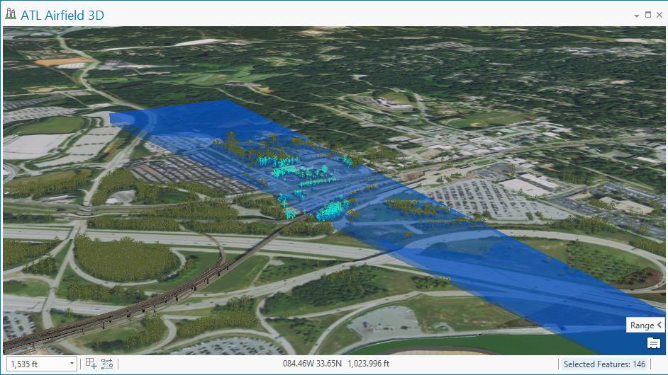
14 Range & Time Sliders Tip # 3A: Take advantage of the range and time sliders to efficiently explore your data. Queries used in a slider will be shown across your map, attribute table, and charts. Essentially a dynamic definition query for your data.


15 Using Charts To Filter Data Tip # 3B: To quickly visualize different categories in your data, create a categorical bar chart and take advantage of the interactive selection sets, as opposed to writing numerous queries.

16 Zoom to Selected Features Button* Tip # 3C: The selected features dialog in the lower right corner of the map frame is actually a button. Click it to quickly zoom to selected features in the map. *Hidden Gem

17 Animation Options Tip # 3D: Add titles and overlays to your animations to provide additional content and context to your data.
18 Check On Learning Can you recall what we ve covered thus far? Q: What is the biggest difference between how ArcMap and ArcGIS Pro are structured? A: ArcMap is map centric, whereas ArcGIS Pro supports project centric workflows, which more closely fits how analysts typically work. Q: What 3D layer property setting can you utilize to improve drawing speed for maps containing large amounts of complex symbol geometries? A: Distance visibility. Essentially a 3D reference scale to determine how far out to start or stop drawing features. Q: What are the two kinds of sliders that act as dynamic definition queries to help you quickly visualize subsets of your data? A: Time & Range.
19 Demo 1
20 Geoprocessing
 Options - Run the Analyze Tools For Pro GP Tool")
21 Check Tools For Compatibility With Pro Tip # 4A: See if your existing tools or scripts will work in Pro by checking for compatibility one of two ways: - Check the option to analyze for compatibility on in the Geoprocessing (GP) Options - Run the Analyze Tools For Pro GP Tool


22 Save Time Using Esri s Services Tip # 4B: If you don t have your own network dataset or address locator, take advantage of various GP tools that use Esri s services from ArcGIS Online, or from your Portal. You can also leverage the Enrich Layer tool to enhance your layer s attributions. You can tell if a tool will consume credits if you see a small coin icon next to it.


23 Open Multiple GP Tools At Once* Tip # 4C: If you ve already opened and filled in parameters for a GP tool, and want to go back and run another first, click the burger button from the Geoprocessing Pane. This will allow you to open a different tool simultaneously, while not losing the parameters you ve already filled in. *Hidden Gem


24 Geoprocessing History Tip # 4D: To speed up iterative workflows, take advantage of using the geoprocessing history that Pro is automatically logging for you. You can then copy and paste the python syntax from a previously run tool to get a head start when writing your own tools/scripts.
25 Editing
, or by number of operations.")
26 Automatically Save Edits Tip # 5A: Set the editing automatic save parameters to ensure you never lose your work. These parameters can be established by time interval (minutes), or by number of operations.
27 Editing Grid Tip # 5B: Take advantage of the editing grid to help you easily digitize features that are parallel and perpendicular to one another. It can be configured to the map by setting the origin, spacing, and rotation.
28 Multipatch Editing Tip # 5C: When working with 3D multipatch geometries, use the multipatch editor to quickly create new features from scratch, or edit existing ones.
29 2D/3D Linked Views Tip # 5D: If your editing workflow calls for visualizing your data in both 2D and 3D, link the views together to simplify your workflow.
30 Layouts


31 Map Series & Dynamic Legends Tip # 6A: When creating multiple maps over the same area, utilize the map series function to save time. You can also take advantage of the dynamic legends feature which will automatically filter your legend to only display features in that map s extent.
32 Guides & Locking Elements Tip # 6B: Use guides to help you quickly and accurately line up your various map elements in your layout. Once set, lock the element in the contents pane to ensure it isn t accidently altered or moved.

33 Adjust Map Extent In A Layout Tip # 6C: To switch between your active maps, highlight the map you want to work with in the contents pane, and click the Activate button from the Layout tab in the ribbon. This will allow you to work with the regular map tools to adjust the zoom and scale of your map.
34 Check On Learning Can you recall what we ve covered thus far? Q: What are two ways you can check to see if your tools/scripts are compatible with Pro? A: Checking on the box for Analyze script and model tools for ArcGIS Pro compatibility in the geoprocessing options, or running the Analyze Tools for Pro GP tool. Q: What are the two ways you can set up automatic saving of your edits? A: By time interval (minutes), or by the number of operations. Q: What is a dynamic legend? A: A legend that only shows the layers for features displayed in your current map s extent. These work great when creating a map series.
35 Demo 2
36 Sharing

37 Sharing Configurations Tip # 7A: Take advantage of different sharing configurations for maps intended for exploratory, editable, or visualization purposes.
 and use a find and replace to redirect many different paths at")
38 Quickly Change File Paths Tip # 7B: To quickly change the file paths for multiple different layers in a map, save it out as a map file, then open in Notepad ++ (or arcpy) and use a find and replace to redirect many different paths at once.
39 Create Scene Layer Package Tip # 7C: Leverage the Create Scene Layer Package geoprocessing tool to share a point cloud to ArcGIS Online, or Portal (10.5.1). Once the package has been created, you can add it back into Pro as a layer to preview the service, or to use for faster visualization. (e.g. LAS dataset).
40 Working with the Ribbon and Panes

41 Keyboard Shortcuts Tip # 8A: On the ribbon, hover over the explore tool to see a screen tip of navigation shortcuts. Additionally, press Alt to reveal further KeyTips.

42 Add Data Preview* Tip # 8B: When using the Add Data window, there is a button in the upper right corner that allows you to change views and preview the data before adding it. *Hidden Gem


43 Docking Panes Tip # 8C: You can interactively dock the various panes around different sides of the application, or on top of one another to be delimited by tabs. In addition, you can float a pane or view (such as the map view) on another monitor.
44 Backstage


45 Taking Pro Offline Tip # 9A: Select the Licensing section backstage, and check the box under Settings to authorize ArcGIS Pro to work offline. To learn more about this, hover over the blue i or press F1 to launch the online help page.
46 Options: Customize the Ribbon Tip # 9B: From the Pro Options window, select the Customize the Ribbon section to add or remove tabs, groups, and tools from the ribbon to tailor Pro for specific teams or workflows in your organization.
47 Options: Dark Theme Tip # 9C: From the Pro Options window, select General > Personalize > Theme to change the look of Pro between light and dark theme. Take advantage of dark theme to minimize eye strain when working in dimly lit spaces and help focus on your content, not the UI.
48 Options: Choose How Projects Are Created Tip # 9D: From the Pro Options window, select General, then uncheck the box next to always create a new folder for a project to help organize your files if you re saving your projects with your data.
49 Options: Navigation Tip # 9E: Adjust the transition time setting under Navigation to get Pro to pan between bookmarks. This is useful when presenting to prevent an audience from becoming disoriented as you move around a map. 2.5 seconds is a good default in most cases.
50 Options: Stereoscopic Mode Tip # 9F: From the Display section of the Pro Options, you can enable or disable stereoscopic rendering, which provides the illusion of depth from your flat monitor by creating two separate images, one for each eye.
51 Check On Learning Can you recall what we ve covered thus far? Q: How do you share a point cloud to ArcGIS Online? A: The Create Scene Layer Package geoprocessing tool. Q: True or False: You can dock a map outside of the application to display it on a separate monitor. A: True. Q: What section of the ArcGIS Pro options is the location of where you can set the application to use dark theme? A: General (then Personalize > Theme)
52 Demo 3
53 Check On Learning Bonus Round Q: What were the three hidden gems covered in this workshop? (hint: there was one in each of the three main sections) A: Zoom to Selected Features Button Opening Multiple Geoprocessing Tools at Once Add Data Button Show Details Panel
54 Summary Project Structure/Set Up 2 Tips & Tricks Data Visualization/Map Authoring...5 Tips & Tricks Data/Map Exploration.4 Tips & Tricks Geoprocessing.4 Tips & Tricks Editing.4 Tips & Tricks Layouts...3 Tips & Tricks Sharing...3 Tips & Tricks Working with the Ribbon & Panes..3 Tips & Tricks Backstage..6 Tips & Tricks 34 Total Tips & Tricks
55 Your Questions?


56 Please Take Our Survey on the Esri Events App! Download the Esri Events app and find your event Select the session you attended Scroll down to find the survey Complete Answers and Select Submit
57 Print Your Certificate of Attendance Print stations located in the 140 Concourse Monday 12:30 PM 6:30 PM GIS Solutions Expo, Hall B Tuesday 10:45 AM 5:15 PM GIS Solutions Expo, Hall B 5:15 PM 6:30 PM Expo Social, Hall B 6:30 PM 9:30 PM Networking Reception, Smithsonian National Air and Space Museum

58
ArcGIS Pro: What s New in Analysis
 Federal GIS Conference February 9 10, 2015 Washington, DC ArcGIS Pro: What s New in Analysis James Sullivan What is analysis? Analysis transforms raw data into information or knowledge. Spatial analysis
ArcGIS Pro: Scripting with Python. John Jennifer Duerr:
 ArcGIS Pro: Scripting with Python John Yaist: jyaist@esri.com @TheMaphaps Jennifer Duerr: jduerr@esri.com Target Audience Experienced ArcGIS Desktop Users Experienced with Python Scripting Curious about
Packaging Projects, Maps and Layers. Shilpi Jain Melanie Summers
 Packaging Projects, Maps and Layers Shilpi Jain Melanie Summers What can be packaged Layer Map Project Layer package (.lypkx) Tile package (.tpk) Scene layer package (.slpk) Map package (.mpkx) Mobile
How to put the Image Services in the Living Atlas to Work in Your GIS. Charlie Frye, Chief Cartographer Esri, Redlands
 How to put the Image Services in the Living Atlas to Work in Your GIS Charlie Frye, Chief Cartographer Esri, Redlands Image Services in the Living Atlas of the World Let s have a look: https://livingatlas.arcgis.com
Fundamentals of ModelBuilder
 Fundamentals of ModelBuilder Agenda An Overview of Geoprocessing Framework Introduction to ModelBuilder Basics of ArcToolbox Using ModelBuilder Documenting Models Sharing Models with Others Q & A Geoprocessing
EDUCATION GIS CONFERENCE Geoprocessing with ArcGIS Pro. Rudy Prosser GISP CTT+ Instructor, Esri
 EDUCATION GIS CONFERENCE Geoprocessing with ArcGIS Pro Rudy Prosser GISP CTT+ Instructor, Esri Maintenance What is geoprocessing? Geoprocessing is - a framework and set of tools for processing geographic
ModelBuilder Getting Started
 2013 Esri International User Conference July 8 12, 2013 San Diego, California Technical Workshop ModelBuilder Getting Started Matt Kennedy Esri UC2013. Technical Workshop. Agenda Geoprocessing overview
ARC HYDRO GROUNDWATER TUTORIALS
 ARC HYDRO GROUNDWATER TUTORIALS Subsurface Analyst Creating ArcMap cross sections from existing cross section images Arc Hydro Groundwater (AHGW) is a geodatabase design for representing groundwater datasets
Analysis and Geoprocessing Sessions and Demo Theater Presentations
 Esri User Conference 2018 Analysis and Geoprocessing Sessions and Demo Theater Presentations TUESDAY 7/10 -------------------------------------------------------------------------------------------------------------------------------------------
Using 3D thematic symbology to display features in a scene
 Using 3D thematic symbology to display features in a scene www.learn.arcgis.com 380 New York Street Redlands, California 92373 8100 USA Copyright 2018 Esri All rights reserved. Printed in the United States
Spatial Analysis with ArcGIS Pro. Krithica Kantharaj, Esri
 Spatial Analysis with ArcGIS Pro Krithica Kantharaj, Esri What is analysis? Analysis transforms raw data into information or knowledge Spatial analysis does this for geographic or spatial data Who? What?
Network Analyst: Automating Workflows with Geoprocessing
 Esri International User Conference San Diego, California Technical Workshops July 25, 2012 Network Analyst: Automating Workflows with Geoprocessing Deelesh Mandloi Patrick Stevens Introductions Who are
AGENDA. Effective Geodatabase Management. Presentation Title. Using Automation. Mohsen Kamal. Name of Speaker Company Name
 AGENDA Effective Geodatabase Management Presentation Title Using Automation Mohsen Kamal Name of Speaker Company Name Agenda Introducing the geodatabase What is a Schema? Schema Creation Options Geoprocessing
UNIGIS University of Salzburg. Module: ArcGIS for Server Lesson: Online Spatial analysis UNIGIS
 1 Upon the completion of this presentation you should be able to: Describe the geoprocessing service capabilities Define supported data types input and output of geoprocessing service Configure a geoprocessing
Geocoding An Introduction
 2013 Esri International User Conference July 8 12, 2013 San Diego, California Technical Workshop Geocoding An Introduction Miriam Schmidts Agatha Wong Esri UC2013. Technical Workshop. Agenda What is geocoding?
Geocoding with ArcGIS FedGIS 2017 (2/14/2017)
") Geocoding with ArcGIS FedGIS 2017 (2/14/2017) Michael Rink, Esri Nick Patel, Esri Agenda Introduction Building a Robust Global Geocoding Experience Overview of Esri s Geocoding products Road Ahead Demo
Geocoding with ArcGIS FedGIS 2017 (2/14/2017) Michael Rink, Esri Nick Patel, Esri Agenda Introduction Building a Robust Global Geocoding Experience Overview of Esri s Geocoding products Road Ahead Demo
Upgrading Common Workflows from 10.2.x to 100.x with ArcGIS Runtime SDK for.net. Melanie Whalen & Lauren Boyd
 Upgrading Common Workflows from 10.2.x to 100.x with ArcGIS Runtime SDK for.net Melanie Whalen & Lauren Boyd Agenda Architectural Overview Maps Editing Analysis Resources Q&A Architectural Overview Architecture:
ArcGIS Pro: What s New in Analysis. Rob Elkins
 ArcGIS Pro: What s New in Analysis Rob Elkins ArcGIS Pro Welcome ArcGIS Pro: Analysis Rob Elkins ArcGIS Pro 1.0 Now Available = + Includes the complete ArcGIS Platform Application fusion Single, always
Building Java Apps with ArcGIS Runtime SDK
 Building Java Apps with ArcGIS Runtime SDK Vijay Gandhi, Elise Acheson, Eric Bader Demo Source code: https://github.com/esri/arcgis-runtime-samples-java/tree/master/devsummit-2014 Video Recording: http://video.esri.com
ArcGIS Runtime: Analysis. Lucas Danzinger Mark Baird Mike Branscomb
 ArcGIS Runtime: Analysis Lucas Danzinger Mark Baird Mike Branscomb ArcGIS Runtime session tracks at DevSummit 2018 ArcGIS Runtime SDKs share a common core, architecture and design Functional sessions promote
Lab Assignment 5 Geoprocessing Service. Due Date: 01/24/2014
 Lab Assignment 5 Geoprocessing Service Due Date: 01/24/2014 Overview Geoprocessing is one of the original purposes or functions when GIS was invented. It provides tools and a framework for performing analysis
Esri UC 2014 Technical Workshop
 Introduction to Parcel Fabric Amir Plans Parcels Control 1 Points 1-1 Line Points - Lines Editing and Maintaining Parcels using Deed Drafter and ArcGIS Desktop What is a parcel fabric? Dataset of related
Objectives Learn how to import and display shapefiles with and without ArcObjects. Learn how to convert the shapefiles to GMS feature objects.
 v. 10.1 GMS 10.1 Tutorial Importing, displaying, and converting shapefiles Objectives Learn how to import and display shapefiles with and without ArcObjects. Learn how to convert the shapefiles to GMS
Section 1. Introduction and Review. Objectives: Log on to the computer Launch AutoCAD Create, open, and save a drawing Review AutoCAD basics
 Section 1 Introduction and Review Objectives: Log on to the computer Launch AutoCAD Create, open, and save a drawing Review AutoCAD basics Drawing Assignments: NCAA Basketball Court Plot Style Table (Check-off)
Learn PowerPoint 2010
 Table of Contents Chapter 1 Introduction Introduction...4 Chapter 2 PowerPoint 2010 Basics Introduction to PowerPoint 2010 Basics...5 Start and Exit...6 PowerPoint 2010 Window...7 The Ribbon...9 The Backstage:
in ArcMap By Mike Price, Entrada/San Juan, Inc.
 Interactively Create and Apply Logarithmic Legends in ArcMap By Mike Price, Entrada/San Juan, Inc. This exercise uses the dataset for Battle Mountain, Nevada, that was used in previous exercises. The Geochemistry
ACDSee Pro 3 tutorials: Pro 3 overview for new users
 In ACDSee Pro Photo Manager 3, the Manage, View, Process and s help to accelerate your photography workflow. You can easily switch between modes depending where you are in your workflow. To switch between
Getting Started Guide
 SOLIDWORKS Getting Started Guide SOLIDWORKS Electrical FIRST Robotics Edition Alexander Ouellet 1/2/2015 Table of Contents INTRODUCTION... 1 What is SOLIDWORKS Electrical?... Error! Bookmark not defined.
ArcGIS Apps and GPS GNSS Connections. By: Colin Lawrence and Kiersten Hudson
 ArcGIS Apps and GPS GNSS Connections By: Colin Lawrence and Kiersten Hudson Agenda ArcGIS Apps and high accuracy data The importance of high accuracy data Making connections to external receivers Bringing
AECOsim Building Designer. Quick Start Guide. Chapter A08 Space Planning Bentley Systems, Incorporated
 AECOsim Building Designer Quick Start Guide Chapter A08 Space Planning 2012 Bentley Systems, Incorporated www.bentley.com/aecosim Table of Contents Space Planning...3 Sketches... 3 SpacePlanner... 4 Create
Tiling. 1. Overlapping tiles with fixed number of tiles. Tutorial
 Tutorial Tiling Software version: Asanti 3.0 Document version: April 3, 2017 This tutorial demonstrates how to use tiling within Asanti. Download the Asanti Sample Files via the Asanti Client (Help > Asanti
Contents Foreword 1 Feedback 2 Legal information 3 Getting started 4 Installing the correct Capture One version 4 Changing the version type 5 Getting
 Contents Foreword 1 Feedback 2 Legal information 3 Getting started 4 Installing the correct Capture One version 4 Changing the version type 5 Getting to know Capture One Pro 6 The Grand Overview 6 The
Creo Parametric Primer
 PTC Creo Parametric - Primer Student and Academic Editions 02 Helpful hints are enclosed in red brackets or round bubbles like this one! Creo Parametric Primer THIS VERSION OF THE CREO PRIMER HAS BEEN
State of Florida Department of Transportation. FDOT Traffic Plans. Signing & Pavement Markings (CE ) Signalization (CE ) Lighting
 Signalization (CE ) Lighting") State of Florida Department of Transportation FDOT Traffic Plans Signing & Pavement Markings (CE-11-0117) Signalization (CE-11-0119) Lighting (CE-11-0118) User Training Manual October 2017 PRODUCTION SUPPORT
State of Florida Department of Transportation FDOT Traffic Plans Signing & Pavement Markings (CE-11-0117) Signalization (CE-11-0119) Lighting (CE-11-0118) User Training Manual October 2017 PRODUCTION SUPPORT
Getting Started. Chapter. Objectives
 Chapter 1 Getting Started Autodesk Inventor has a context-sensitive user interface that provides you with the tools relevant to the tasks being performed. A comprehensive online help and tutorial system
ADOBE BRIDGE. Help and tutorials
 ADOBE BRIDGE Help and tutorials September 2013 Contents What s new... 1 What s new in Adobe Bridge CC... 2 What s new in Adobe Bridge CS6... 4 Adobe Bridge... 5 About Adobe Bridge... 6 Start Adobe Bridge...
Objectives Learn how to import and display shapefiles in GMS. Learn how to convert the shapefiles to GMS feature objects. Required Components
 v. 10.3 GMS 10.3 Tutorial Importing, displaying, and converting shapefiles Objectives Learn how to import and display shapefiles in GMS. Learn how to convert the shapefiles to GMS feature objects. Prerequisite
THE LIST USABILITY PUG 2007
 THE LIST USABILITY PUG 2007 Layer/Map Management Working with many layers, maps and data sets Direction that ESRI is taking with the Geodatabase Information Model Direction that ESRI is taking with GIS
Transforming Your Photographs with Photoshop
 Transforming Your Photographs with Photoshop Jesús Ramirez PhotoshopTrainingChannel.com Contents Introduction 2 About the Instructor 2 Lab Project Files 2 Lab Objectives 2 Lab Description 2 Removing Distracting
AutoCAD 2D. Table of Contents. Lesson 1 Getting Started
 AutoCAD 2D Lesson 1 Getting Started Pre-reqs/Technical Skills Basic computer use Expectations Read lesson material Implement steps in software while reading through lesson material Complete quiz on Blackboard
GIS Module GMS 7.0 TUTORIALS. 1 Introduction. 1.1 Contents
 GMS 7.0 TUTORIALS 1 Introduction The GIS module can be used to display data from a GIS database directly in GMS without having to convert that data to GMS data types. Native GMS data such as grids and
MODULE 1 HAZARDOUS EMERGENCY DECISIONS
 MODULE INTRODUCTION Accidents, natural disasters, and terrorism produce chaotic homeland security situations that require a coordinated response based on sound information. GIS, when applied to these emergencies,
Creating Geoprocessing Services
 Esri International User Conference San Diego, California Technical Workshops July 25, 2012 Creating Geoprocessing Services Kevin Hibma, Scott Murray Analysis and Geoprocessing Resource Center Quick Links:
Geography 281 Map Making with GIS Project Ten: Mapping and Spatial Analysis
 Geography 281 Map Making with GIS Project Ten: Mapping and Spatial Analysis This project introduces three techniques that enable you to manipulate the spatial boundaries of geographic features: Clipping
SECTION GEOGRAPHIC INFORMATION SYSTEM (GIS)
") PART 1 - GENERAL 1.1 DESCRIPTION SECTION 11 83 01 A. Provide all labor, materials, manpower, tools and equipment required to furnish, install, activate and test a new Geographic Information System (GIS).
PART 1 - GENERAL 1.1 DESCRIPTION SECTION 11 83 01 A. Provide all labor, materials, manpower, tools and equipment required to furnish, install, activate and test a new Geographic Information System (GIS).
Using Geoprocessing Services with ArcGIS Web Mapping APIs
 Using Geoprocessing Services with ArcGIS Web Mapping APIs Monica Joseph, Scott Murray Please fill session survey. What is a Geoprocessing Service? A geoprocessing service is a set of geoprocessing tools
12. Creating a Product Mockup in Perspective
 12. Creating a Product Mockup in Perspective Lesson overview In this lesson, you ll learn how to do the following: Understand perspective drawing. Use grid presets. Adjust the perspective grid. Draw and
Using Dynamic Views. Module Overview. Module Prerequisites. Module Objectives
 Using Dynamic Views Module Overview The term dynamic views refers to a method of composing drawings that is a new approach to managing projects. Dynamic views can help you to: automate sheet creation;
v. 8.0 GMS 8.0 Tutorial GIS Module Shapefile import, display, and conversion Prerequisite Tutorials None Time minutes
 v. 8.0 GMS 8.0 Tutorial Shapefile import, display, and conversion Objectives Learn how to import and display shapefiles with and without ArcObjects. Convert the shapefiles to GMS feature objects. Prerequisite
House Design Tutorial
 House Design Tutorial This House Design Tutorial shows you how to get started on a design project. The tutorials that follow continue with the same plan. When you are finished, you will have created a
Welcome to Storyist. The Novel Template This template provides a starting point for a novel manuscript and includes:
 Welcome to Storyist Storyist is a powerful writing environment for ipad that lets you create, revise, and review your work wherever inspiration strikes. Creating a New Project When you first launch Storyist,
House Design Tutorial
 House Design Tutorial This House Design Tutorial shows you how to get started on a design project. The tutorials that follow continue with the same plan. When you are finished, you will have created a
Alibre Design Tutorial: Loft, Extrude, & Revolve Cut Loft-Tube-1
 Alibre Design Tutorial: Loft, Extrude, & Revolve Cut Loft-Tube-1 Part Tutorial Exercise 5: Loft-Tube-1 [Complete] In this Exercise, We will set System Parameters first, then part options. Then, in sketch
Copyright Digital Film Tools, LLC All Rights Reserved
 2 About this Guide ABOUT THIS GUIDE This User Guide is a reference for the Rays plug-in made for Adobe Photoshop, Adobe Photoshop Lightroom, Adobe Photoshop Elements and Apple Aperture. You can read from
Analysis & Geoprocessing: Case Studies Problem Solving
 Analysis & Geoprocessing: Case Studies Problem Solving Shawn Marie Simpson Federal User Conference 2008 3 Overview Analysis & Geoprocessing Review What is it? How can I use it to answer questions? Case
Managing Imagery and Raster Data. Peter Becker
 Managing Imagery and Raster Data Peter Becker ArcGIS is a Comprehensive Imagery Platform Empowering you to make informed decisions System of Engagement System of Insight Extract Information from Imagery
A Quick Spin on Autodesk Revit Building
 11/28/2005-3:00 pm - 4:30 pm Room:Americas Seminar [Lab] (Dolphin) Walt Disney World Swan and Dolphin Resort Orlando, Florida A Quick Spin on Autodesk Revit Building Amy Fietkau - Autodesk and John Jansen;
ArcGIS Runtime SDK for Java: Building Applications. Eric
 ArcGIS Runtime SDK for Java: Building Applications Eric Bader @ECBader Agenda ArcGIS Runtime and the SDK for Java How to build / Functionality - Maps, Layers and Visualization - Geometry Engine - Routing
Getting Started with. Vectorworks Architect
 Getting Started with Vectorworks Architect Table of Contents Introduction...2 Section 1: Program Installation and Setup...6 Installing the Vectorworks Architect Program...6 Exercise 1: Launching the Program
Session 3 _ Part A Effective Coordination with Revit Models
 Session 3 _ Part A Effective Coordination with Revit Models Class Description Effective coordination relies upon a measured strategic approach to using clash detection software. This class will share best
CBCL Limited Sheet Set Manager Tutorial 2013 REV. 02. CBCL Design Management & Best CAD Practices. Our Vision
 CBCL Limited Sheet Set Manager Tutorial CBCL Design Management & Best CAD Practices 2013 REV. 02 Our Vision To be the most respected and successful Atlantic Canada based employeeowned firm, delivering
ArcGIS Tutorial: Geocoding Addresses
 U ArcGIS Tutorial: Geocoding Addresses Introduction Address data can be applied to a variety of research questions using GIS. Once imported into a GIS, you can spatially display the address locations and
Understanding OpenGL
 This document provides an overview of the OpenGL implementation in Boris Red. About OpenGL OpenGL is a cross-platform standard for 3D acceleration. GL stands for graphics library. Open refers to the ongoing,
CS Problem Solving and Structured Programming Lab 1 - Introduction to Programming in Alice designed by Barb Lerner Due: February 9/10
 CS 101 - Problem Solving and Structured Programming Lab 1 - Introduction to Programming in lice designed by Barb Lerner Due: February 9/10 Getting Started with lice lice is installed on the computers in
Zooming in on Architectural Desktop Layouts Alexander L. Wood
 December 2-5, 2003 MGM Grand Hotel Las Vegas Alexander L. Wood Code BD41-3L Take advantage of both AutoCAD and Autodesk Architectural Desktop Layout features. We'll look at the basics of setting up AutoCAD
Cricut Design Space App for ipad User Manual
 Cricut Design Space App for ipad User Manual Cricut Explore design-and-cut system From inspiration to creation in just a few taps! Cricut Design Space App for ipad 1. ipad Setup A. Setting up the app B.
Home Screen to Get You Started
 Updated User Interface The user interface has been redesigned for faster learning and more complete designing. Its friendly new look introduces large interface elements, customizable workspace, help tips,
Share My Design Space Project to Facebook or Pinterest?
 How Do I Share My Design Space Project to Facebook or Pinterest? We love it when our members share the projects they create daily with their Cricut machines, materials, and accessories. Design Space was
I Read Banned Books Poster File Tip Sheet. The Basics
 I Read Banned Books Poster File Tip Sheet The Basics Open the poster file using photo editing software that can support PSD files, such as Adobe Photoshop, Photoshop Elements, or GIMP, a free photo editor
Exercise 1: The AutoCAD Civil 3D Environment
 Exercise 1: The AutoCAD Civil 3D Environment AutoCAD Civil 3D Interface Object Base Layer Object Component Layers 1-1 Introduction to Commercial Site Grading Plans AutoCAD Civil 3D Interface AutoCAD Civil
Top Storyline Time-Saving Tips and. Techniques
 Top Storyline Time-Saving Tips and Techniques New and experienced Storyline users can power-up their productivity with these simple (but frequently overlooked) time savers. Pacific Blue Solutions 55 Newhall
Public Safety Geocoding Using ArcGIS Online and HERE Data
 Public Safety Geocoding Using ArcGIS Online and HERE Data I. Knowledge, Skills, and Abilities (KSAs) Supported This training module aids in the development of several KSAs that are fundamental to using
Release Notes - Fixes in Tekla Structures 2016i SP1
 Release Notes - Fixes in Tekla Structures 2016i SP1 is modified., the ID of the connection plate is not changed anymore when the connection now uses normal rebar groups instead of tapered groups., the
Introduction to Autodesk Inventor for F1 in Schools (Australian Version)
") Introduction to Autodesk Inventor for F1 in Schools (Australian Version) F1 in Schools race car In this course you will be introduced to Autodesk Inventor, which is the centerpiece of Autodesk s Digital
Introduction to Autodesk Inventor for F1 in Schools (Australian Version) F1 in Schools race car In this course you will be introduced to Autodesk Inventor, which is the centerpiece of Autodesk s Digital
The original image. Let s get started! The final rainbow effect. The photo sits on the Background layer in the Layers panel.
 Add A Realistic Rainbow To A Photo In this Photoshop photo effects tutorial, we ll learn how to easily add a rainbow, and even a double rainbow, to a photo! As we ll see, Photoshop ships with a ready-made
The original photo. The final result.
 giving a photo painted edges In this Adobe Photoshop tutorial, we re going to combine a couple of different effects. First, we ll give the photo easy-tocreate painted edges, and then we ll make it look
Watershed Sciences 4930 & 6920 GEOGRAPHIC INFORMATION SYSTEMS
 Slides by Wheaton et al. (2009-2014) are licensed under a Creative Commons Attribution-NonCommercial-ShareAlike 3.0 Unported License Watershed Sciences 4930 & 6920 GEOGRAPHIC INFORMATION SYSTEMS INTRODUCTION
House Design Tutorial
 Chapter 2: House Design Tutorial This House Design Tutorial shows you how to get started on a design project. The tutorials that follow continue with the same plan. When you are finished, you will have
COPYRIGHTED MATERIAL. Welcome to the Civil 3D Environment
 Welcome to the Civil 3D Environment Chapter 1 To paraphrase, Civil 3D isn t your father s AutoCAD. If you re just getting into the Civil 3D environment, want to learn how to get around in models, and would
Solving tasks and move score... 18
 Solving tasks and move score... 18 Contents Contents... 1 Introduction... 3 Welcome to Peshk@!... 3 System requirements... 3 Software installation... 4 Technical support service... 4 User interface...
Revit Structure 2012 Basics:
 SUPPLEMENTAL FILES ON CD Revit Structure 2012 Basics: Framing and Documentation Elise Moss autodesk authorized publisher SDC PUBLICATIONS www.sdcpublications.com Schroff Development Corporation Structural
File Button 9 Font Creator 251. Gifts in the Hoop 413 Grid 53 Grouping 93. Installing Adding a shortcut 24 Checking for updates 23 Full version 17
 A Alignment Aligning multiple pieces 345 Alignment is similar to Applique position 340 Different color for alignment lines 345 Using Thumb tacks for Alignment 340 Why Straight Alignment lines 344 Applique
Silhouette Connect Layout... 4 The Preview Window... 5 Undo/Redo... 5 Navigational Zoom Tools... 5 Cut Options... 6
 user s manual Table of Contents Introduction... 3 Sending Designs to Silhouette Connect... 3 Sending a Design to Silhouette Connect from Adobe Illustrator... 3 Sending a Design to Silhouette Connect from
House Design Tutorial
 Chapter 2: House Design Tutorial This House Design Tutorial shows you how to get started on a design project. The tutorials that follow continue with the same plan. When you are finished, you will have
User Guide US AUS Avontus Software Corporation. All Rights Reserved
 User Guide Scaffold Designer is a simple but powerful scaffold drawing tool that allows the design of scaffold structures of any complexity and generates a bill of materials automatically. This guide covers
From Nothing to Something using AutoCAD Electrical
 From Nothing to Something using AutoCAD Electrical Todd Schmoock Synergis Technologies MA2085-L: You purchased AutoCAD Electrical, or are thinking about purchasing it, but you do not know how to use it.
Getting Started with. Vectorworks Architect
 Getting Started with Vectorworks Architect Table of Contents Introduction...2 Section 1: Program Installation and Setup...6 Installing the Vectorworks Architect Program...6 Exercise 1: Launching the Program
User Guide / Rules (v1.6)
") BLACKJACK MULTI HAND User Guide / Rules (v1.6) 1. OVERVIEW You play our Blackjack game against a dealer. The dealer has eight decks of cards, all mixed together. The purpose of Blackjack is to have a hand
BLACKJACK MULTI HAND User Guide / Rules (v1.6) 1. OVERVIEW You play our Blackjack game against a dealer. The dealer has eight decks of cards, all mixed together. The purpose of Blackjack is to have a hand
Falsework & Formwork Visualisation Software
 User Guide Falsework & Formwork Visualisation Software The launch of cements our position as leaders in the use of visualisation technology to benefit our customers and clients. Our award winning, innovative
Virtual components in assemblies
 Virtual components in assemblies Publication Number spse01690 Virtual components in assemblies Publication Number spse01690 Proprietary and restricted rights notice This software and related documentation
Module 1G: Creating a Circle-Based Cylindrical Sheet-metal Lateral Piece with an Overlaying Lateral Edge Seam And Dove-Tail Seams on the Top Edge
 Inventor (10) Module 1G: 1G- 1 Module 1G: Creating a Circle-Based Cylindrical Sheet-metal Lateral Piece with an Overlaying Lateral Edge Seam And Dove-Tail Seams on the Top Edge In Module 1A, we have explored
Roland VersaWorks. Creating Profiles with VersaWorks 3
 Roland VersaWorks Creating Profiles with VersaWorks 3 Profiling a Media with Roland VersaWorks This document describes the procedure for creating media profiles in VersaWorks. VersaWorks provides profiling
Session 3: Python Geoprocessing
 Session 3: Python Geoprocessing In this session we use ArcGIS geoprocessing tools in the Python window. Typically you first set your environment and extensions. For example, copy (Ctrl-C) following from
Second Third
 STEP 1: Everything that you draw in is exact. It will be more accurate than you will ever need it to be, All objects drawn on the screen are placed there based on a simple X,Y coordinate system. In this
Creating Transparency for Glass in an Illustration with. SketchBook Designer
 Autodesk Design Suite 2012 Autodesk SketchBook Designer 2012 Tip Guides Creating Transparency for Glass in an Illustration with SketchBook Designer In this section you will learn the following: How to
Sense. 3D scanning application for Intel RealSense 3D Cameras. Capture your world in 3D. User Guide. Original Instructions
 Sense 3D scanning application for Intel RealSense 3D Cameras Capture your world in 3D User Guide Original Instructions TABLE OF CONTENTS 1 INTRODUCTION.... 3 COPYRIGHT.... 3 2 SENSE SOFTWARE SETUP....
Image Editor. Opening Image Editor. Click here to expand Table of Contents...
 Image Editor Click here to expand Table of Contents... Opening Image Editor Image Editor Sorting and Filtering Using the Image Editor Source Tab Image Type Color Space Alpha Channel Interlace Mipmapping
Neat Image. User guide. To make images look better. Document version 4.2, January 10, Copyright by ABSoft. All rights reserved.
 To make images look better. User guide Document version 4.2, January 10, 2005 Table of contents 1. Introduction...3 1.1. Overview...3 1.2. Features...3 1.3. Requirements...4 2. Key concepts...5 2.1. What
Template: Quilter Title Overview: Traditional Application
 Template: Quilter Title Overview: Traditional Application Subject Launching Topic Quilter Open Steps BERNINA Embroidery Software. Select Steps the Quilter icon in the Applications Toolbox to launch Quilter.
2809 CAD TRAINING: Part 1 Sketching and Making 3D Parts. Contents
 Contents Getting Started... 2 Lesson 1:... 3 Lesson 2:... 13 Lesson 3:... 19 Lesson 4:... 23 Lesson 5:... 25 Final Project:... 28 Getting Started Get Autodesk Inventor Go to http://students.autodesk.com/