GPS for GIS Data Collection - 101
|
|
|
- Melvin Gilmore
- 6 years ago
- Views:
Transcription
1 GPS for GIS Data Collection Speaker: Eric Gakstatter, Editor of GPS World s Survey Scene Newsletter & Geospatial Solutions Guest Commentator: Craig Greenwald, Technical Director, GeoMobile Innovations, Inc.

2 Background (1) - Definitions GPS Global Positioning System -A constellation of ~30 satellites orbiting the Earth. -A GPS receiver uses measurements from several satellites to determine its position on the Earth. -GPS signals free to use by anyone anywhere in the world.
3 Background (2) - Definitions GIS Geographic Information System -Computer hardware and software used to store, manipulate, map and analyze geographic data. -Features (points, lines, polygons) are stored in a particular coordinate system (UTM, SPC, Latitude/longitude, etc.) with each having a unique coordinate on the Earth. -A table of descriptive information, called attributes, may be attached to each geographic location. -Data for a GIS come from a variety of sources.
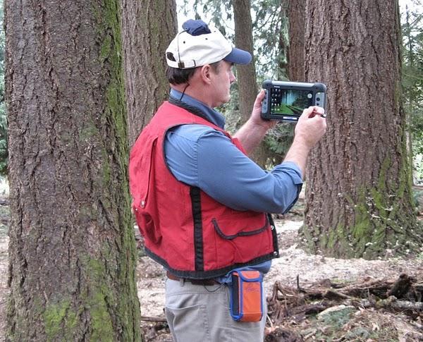
4 Background (3) - Definitions GPS + GIS GPS is one tool that is used to acquire data for GIS. -It can be a handheld (or backpack) GPS system used by a person on foot to record detailed location and descriptive information on the ground. -It can be a digital camera with GPS capability. -It can be a GPS receiver continuously logging data as you re driving a rural road and recording a tracklog.
5 What Exactly is GPS used for in a GIS? -To record accurate position data on the ground (vs. remote sensing or other source of data). -To record detailed attribute information about the features you are recording. Example: Feature Name: Utility Pole Attributes: 60 ft high, AT&T, fair condition, Treated in 2008 Coordinate: , (State Plane NAD83)
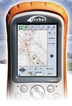
6 What equipment/software is needed? -Equipment Required: GPS receiver, data recording device. -Software Required: Data collection software. -There are many, many different configurations of GPS receivers, data recording devices and software, but primarily two distinct configurations exist: 1. All-in-one handhelds 2. Separate PDA and GPS receiver -The details of your project such as accuracy required and type of data to be collected will determine which configuration is best for you.


7 Consider your requirements
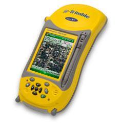
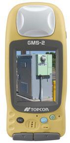
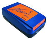
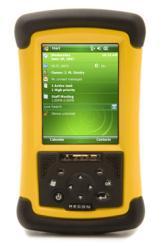
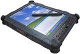

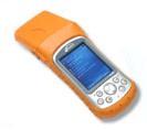
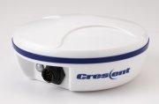

8 All-in-one vs. Stand alone -All-in-one = Simplicity -Stand-alone = Flexibility or or + or or
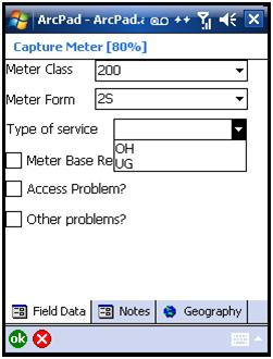
9 Software Considerations? -Support for form design and field data entry rules. -Coordinate system and datum support. -Compatibility between field device and desktop software. -Real-time syncing and multi-user editing in the field. -Integration with devices (laser, camera, barcode, probes). -Capturing GPS quality metadata. -Advanced features such as nested points, offsets, point averaging and all feature capture modes (point, line, polygons).

10 Field Software Choices
11 Equipment/software selection example -Utility pole mapping project: Budget = $5,000 -Required accuracy = 1 meter (horizontal -Data collection = point data with attributes. -Data collection environment = moderately clear sky. -The basic configuration would include a GPS receiver, data collector, data collection software, training, accessories. Optional: laser rangefinder.
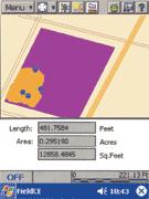
12 GIS data = Point, Line, Polygon -Point = a single coordinate representing a single feature. Example - utility pole. -Line = a series of coordinates joined together to form a line. Example - Centerline of a road. -Polygon = a closed line that ends at the same point it started. Example Wetland area.
13
14 Point Averaging -By default, GPS receivers compute a position once per second. -For recording point features, users typically average data for as little as 3 seconds and for as long as 3 minutes. -The value of averaging can be deceptive. Better to average 5 seconds of stable, good quality data than 3 minutes of unstable, lower quality data.
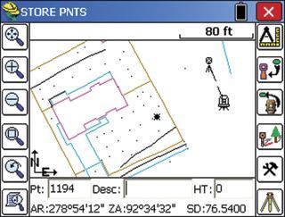
15 Static vs. Dynamic -Line and polygon features can be collected using static or dynamic technique. -Dynamic (continuous) means line/polygon data will be stored once per second after your tap the STORE button. This technique assumes you are continuously moving. -Static data collection is like traditional traversing. Each vertices along the line/polygon is stored when you tap the STORE button. You must stop at each vertices along the line/polygon.

16 Offset Points -Sometimes it s not efficient or necessary to walk/drive up to each point and record it with GPS. -Some data collection software allows you to enter a distance and bearing from where you are located. -You either estimate the distance and bearing manually or use a handheld laser rangefinder to automatically record the distance and bearing.


17 Photo-geotagging -Take existing photos in the field for verification or field ident. -Shoot new photos as attributes or georeferenced.. -Associate photos taken in the field with corresponding features in the office. -Minimize file shuffle. -Minimize non-meaningful filenames. -EXIF extension to JPG to store metadata. Supports GPS and range data.
18 GPS How Accurate is it? Depends on: -Receiver quality -Type of correction method (of any) -Environment the GPS receiver will be used in. Generally speaking, the more accurate the GPS receiver, the more expensive it is.
19 GPS How Accurate is it? It depends -Receiver quality, type of correction method (of any) -Environment the GPS receiver will be used in. -GPS receivers can be classified by accuracy (horizontal): -cm-level -decimeter-level -sub-meter -1-3 meters -3-5 meters -5+ meters -Generally speaking: better accuracy = more expensive. -Vertical accuracy is at least 1.5 times worse than horizontal and even unusable on lower-end receivers.
20 GPS Differential Correction -Differential Correction improves the accuracy of GPS data and is necessary if you require for accuracy below 5 meters. -Real-time correction you receive corrections in the field wirelessly. -Post-processing you download reference GPS data after your field work and correct your data. Requires software. -Example methods of real-time correction services: SBAS (WAAS/EGNOS/MSAS), DGPS beacon, RTK Networks, OmniSTAR, Starfire. Some are free of charge, some are not.
21 GPS Data Quality -GPS signals are affected by obstructions (trees, buildings, terrain) that can degrade accuracy. -The more GPS satellites your receiver is tracking, the better. -The more spread-out (geometrically) the GPS satellites are in the sky, the better your positions will be. -The quality of the geometry of the satellites your receiver is tracking is indicated by the PDOP value. -Precision Dilution of Precision (PDOP) is displayed by all GPS receivers. The lower the PDOP, the better. A PDOP value of 1-3 is ideal. 3-5 is moderate. 5+ is poor.
22 GPS Gotchas -Unrealistic GPS accuracy expectations. -Unrealistic GPS tracking expectations. -Difficulty in accurately matching GPS-collected data to base map (datum transformation). -Unexpected hardware and/or software maintenance and training costs. -Not trying the system in your environment before purchasing. -Lack of metadata in GPS-collected data. -Lack of responsive or capable technical support.


23 QUESTIONS? Eric Gakstatter Craig Greenwald Subscribe to Survey Scene Newsletter at Subscribe to Geospatial Solutions Newsletter at
GNSS Technology Update
 GNSS Technology Update Speaker: Eric Gakstatter Contributing Editor GPS World Editor - Geospatial Solutions Presented at: Association of Petroleum Surveying & Geomatics Houston, TX April 7, 2015 Agenda
Lecture 8: GIS Data Error & GPS Technology
 Lecture 8: GIS Data Error & GPS Technology A. Introduction We have spent the beginning of this class discussing some basic information regarding GIS technology. Now that you have a grasp of the basic terminology
NJDEP GPS Data Collection Standards for GIS Data Development
 NJDEP GPS Data Collection Standards for GIS Data Development Bureau of Geographic Information Systems Office of Information Resource Management April 24 th, 2017 Table of Contents 1.0 Introduction... 3
NR402 GIS Applications in Natural Resources
 NR402 GIS Applications in Natural Resources Lesson 5 GPS/GIS integration Global Positioning System (GPS)..a global navigation system that everyone can use What is GPS? How does it work? How accurate is
Appendix D Brief GPS Overview
 Appendix D Brief GPS Overview Global Positioning System (GPS) Theory What is GPS? The Global Positioning System (GPS) is a satellite-based navigation system, providing position information, accurate to
GPS Errors. Figure 1. Four satellites are required to determine a GPS position.
 Expl ai ni nggps:thegl obalposi t i oni ngsyst em since a minimum of four satellites is required to calculate a position (Fig 1). However, many newer GPS receivers are equipped to receive up to 12 satellite
Datum Transformations: Nightmare on GIS Street. Agenda
 Datum Transformations: Nightmare on GIS Street Speaker: Eric Gakstatter Contributing Editor GPS World Editor - Geospatial Solutions Presented at: Minnesota Society of Professional Surveyors Bloomington,
The Global Positioning System II Field Experiments
 The Global Positioning System II Field Experiments 5-1 Mexico DGPS Field Campaign Cenotes in Tamaulipas, MX, near Aldama 5-2 Are Cenote Water Levels Related? 5-3 DGPS Static Survey of Cenote Water Levels
Line and polygon features can be created via on-screen digitizing.
 This module explains how GPS works, sources of error, and error correction using real time or post processing differential correction. Cost and accuracy of different grades of GPS units are also part of
The Global Positioning Sytem II 10/19/2017
 The Global Positioning System II Field Experiments 10/19/2017 5-1 Mexico DGPS Field Campaign Cenotes in Tamaulipas, MX, near Aldama 10/19/2017 5-2 Are Cenote Water Levels Related? 10/19/2017 5-3 M. Helper,
Suveying Lectures for CE 498
 Suveying Lectures for CE 498 SURVEYING CLASSIFICATIONS Surveying work can be classified as follows: 1- Preliminary Surveying In this surveying the detailed data are collected by determining its locations
Global Positioning Systems (GPS) Trails: the achilles heel of mapping from the air / satellites
 Trails: the achilles heel of mapping from the air / satellites") Global Positioning Systems (GPS) Trails: the achilles heel of mapping from the air / satellites Google maps updated regularly by local users using GPS Also: http://openstreetmaps.org GPS applications
Global Positioning Systems (GPS) Trails: the achilles heel of mapping from the air / satellites Google maps updated regularly by local users using GPS Also: http://openstreetmaps.org GPS applications
Precise Positioning with NovAtel CORRECT Including Performance Analysis
 Precise Positioning with NovAtel CORRECT Including Performance Analysis NovAtel White Paper April 2015 Overview This article provides an overview of the challenges and techniques of precise GNSS positioning.
The Global Positioning System
 The Global Positioning System 5-1 US GPS Facts of Note DoD navigation system First launch on 22 Feb 1978, fully operational in 1994 ~$15 billion (?) invested to date 24 (+/-) Earth-orbiting satellites
GPS: The Basics. Darrell R. Dean, Jr. Civil and Environmental Engineering West Virginia University. Expected Learning Outcomes for GPS
 GPS: The Basics Darrell R. Dean, Jr. Civil and Environmental Engineering West Virginia University Expected Learning Outcomes for GPS Explain the acronym GPS Name 3 important tdt dates in history of GPS
GPS Milestones, cont. GPS Milestones. The Global Positioning Sytem, Part 1 10/10/2017. M. Helper, GEO 327G/386G, UT Austin 1. US GPS Facts of Note
 The Global Positioning System US GPS Facts of Note DoD navigation system First launch on 22 Feb 1978, fully operational in 1994 ~$15 billion (?) invested to date 24 (+/-) Earth-orbiting satellites (SVs)
ACCURACIES OF VARIOUS GPS ANTENNAS UNDER FORESTED CONDITIONS
 ACCURACIES OF VARIOUS GPS ANTENNAS UNDER FORESTED CONDITIONS Brian H. Holley and Michael D. Yawn LandMark Systems, 122 Byrd Way Warner Robins, GA 31088 ABSTRACT GPS accuracy is much more variable in forested
Precise Point Positioning (PPP) using
 using") Precise Point Positioning (PPP) using Product Technical Notes // May 2009 OnPOZ is a product line of Effigis. EZSurv is a registered trademark of Effigis. All other trademarks are registered or recognized
Precise Point Positioning (PPP) using Product Technical Notes // May 2009 OnPOZ is a product line of Effigis. EZSurv is a registered trademark of Effigis. All other trademarks are registered or recognized
GPS Pathfinder ProXH and ProXT Customer FAQs
 7 December 2009 GPS Pathfinder ProXH and ProXT Customer FAQs What is the GPS Pathfinder ProXH receiver? The GPS Pathfinder ProXH receiver is a fully integrated receiver, antenna and battery unit with Trimble
The Global Positioning System II Field Experiments. 10/10/2013 GEO327G/386G, UT Austin 5-1
 The Global Positioning System II Field Experiments 10/10/2013 GEO327G/386G, UT Austin 5-1 Mexico DGPS Field Campaign Cenotes in Tamaulipas, MX, near Aldama 10/10/2013 GEO327G/386G, UT Austin 5-2 Are Cenote
PRINCIPLES AND FUNCTIONING OF GPS/ DGPS /ETS ER A. K. ATABUDHI, ORSAC
 PRINCIPLES AND FUNCTIONING OF GPS/ DGPS /ETS ER A. K. ATABUDHI, ORSAC GPS GPS, which stands for Global Positioning System, is the only system today able to show you your exact position on the Earth anytime,
Errors in GPS. Errors in GPS. Geodetic Co-ordinate system. R. Khosla Fall Semester
 Errors in GPS Errors in GPS GPS is currently the most accurate positioning system available globally. Although we are talking about extreme precision and measuring distances by speed of light, yet there
Introduction to NAVSTAR GPS
 Introduction to NAVSTAR GPS Charlie Leonard, 1999 (revised 2001, 2002) The History of GPS Feasibility studies begun in 1960 s. Pentagon appropriates funding in 1973. First satellite launched in 1978. System
GeoExplorer 6000 series: Customer FAQs
 16 July 2012 GeoExplorer 6000 series: Customer FAQs This document includes information about the Trimble GeoExplorer 6000 series GeoXH and GeoXT handhelds. For information about the Trimble GeoXR Network
GNSS & Coordinate Systems
 GNSS & Coordinate Systems Matthew McAdam, Marcelo Santos University of New Brunswick, Department of Geodesy and Geomatics Engineering, Fredericton, NB May 29, 2012 Santos, 2004 msantos@unb.ca 1 GNSS GNSS
GPS: What do I need to collect Application Appropriate location data?
 GPS: What do I need to collect Application Appropriate location data? Bob Goodwin, GISP GIS/Remote Sensing Analyst Remote Sensing & GIS Research and Outreach Services, MSU http://www.rsgis.msu.edu 2005
Best field practices for GIS Data collection: Presented by, Jacob Wittenberg Frontier Precision, Inc.
 Best field practices for GIS Data collection: Presented by, Jacob Wittenberg Frontier Precision, Inc. Agenda What is GNSS Code and Carrier Data H-Star Processing Best Practices Code and Carrier Solutions
FieldGenius Technical Notes GPS Terminology
 FieldGenius Technical Notes GPS Terminology Almanac A set of Keplerian orbital parameters which allow the satellite positions to be predicted into the future. Ambiguity An integer value of the number of
GEO 428: DEMs from GPS, Imagery, & Lidar Tuesday, September 11
 GEO 428: DEMs from GPS, Imagery, & Lidar Tuesday, September 11 Global Positioning Systems GPS is a technology that provides Location coordinates Elevation For any location with a decent view of the sky
Datums for a Dynamic Earth
 Datums for a Dynamic Earth Based on a paper given at the American Society of Agricultural and Biological Engineers (ASABE) Conference in Reno, Nevada June 2009 Rollin StrohmanPh.D. Tom Mastin L.S Background
Asian Journal of Science and Technology Vol. 08, Issue, 11, pp , November, 2017 RESEARCH ARTICLE
 Available Online at http://www.journalajst.com ASIAN JOURNAL OF SCIENCE AND TECHNOLOGY ISSN: 0976-3376 Asian Journal of Science and Technology Vol. 08, Issue, 11, pp.6697-6703, November, 2017 ARTICLE INFO
Introduction to the Global Positioning System
 GPS for ICS - 2003 Introduction to the Global Positioning System Pre-Work Pre-Work Objectives Describe at least three sources of GPS signal error, and ways to mitigate or reduce those errors. Identify
ArcGIS Apps and GPS GNSS Connections. By: Colin Lawrence and Kiersten Hudson
 ArcGIS Apps and GPS GNSS Connections By: Colin Lawrence and Kiersten Hudson Agenda ArcGIS Apps and high accuracy data The importance of high accuracy data Making connections to external receivers Bringing
What is a GPS How does GPS work? GPS Segments GPS P osition Position Position Accuracy Accuracy Accuracy GPS A pplications Applications Applications
 What is GPS? What is a GPS How does GPS work? GPS Segments GPS Position Accuracy GPS Applications What is GPS? The Global Positioning System (GPS) is a precise worldwide radio-navigation system, and consists
Sources of Geographic Information
 Sources of Geographic Information Data properties: Spatial data, i.e. data that are associated with geographic locations Data format: digital (analog data for traditional paper maps) Data Inputs: sampled
Introduction to the Global Positioning System
 GPS for Fire Management - 2004 Introduction to the Global Positioning System Pre-Work Pre-Work Objectives Describe at least three sources of GPS signal error, and identify ways to mitigate or reduce those
ProMark 3 RTK. White Paper
 ProMark 3 RTK White Paper Table of Contents 1. Introduction... 1 2. ProMark3 RTK Operational Environment... 2 3. BLADE TM : A Unique Magellan Technology for Quicker Convergence... 3 4. ProMark3 RTK Fixed
TSC1 - Asset Surveyor Operation
 TSC1 - Asset Surveyor Operation Menu Icons (current choice is highlighted) Data collection File manager Main menu Navigation GPS Position Battery Status PC Card (if used) Real-Time Status Number of Satellites
GLOBAL POSITIONING SYSTEMS. Knowing where and when
 GLOBAL POSITIONING SYSTEMS Knowing where and when Overview Continuous position fixes Worldwide coverage Latitude/Longitude/Height Centimeter accuracy Accurate time Feasibility studies begun in 1960 s.
Utilizing A GNSS Network Solution for Utility Applications
 Utilizing A GNSS Network Solution for Utility Applications David Newcomer, PE, PLS GPServ, Inc. newcomer@ (407) 601-5816 AGENDA Types and accuracies of data collection o Autonomous o Meter + o Sub-meter
Opportunities and Limitations of Automatic Steering Technologies. Nyle Wollenhaupt Advanced Technology Solutions Agronomist
 Opportunities and Limitations of Automatic Steering Technologies Nyle Wollenhaupt Advanced Technology Solutions Agronomist So where do we start? We start at the beginning. When we didn t have GPS-assisted
One Source for Positioning Success
 novatel.com One Source for Positioning Success RTK, PPP, SBAS OR DGNSS. NOVATEL CORRECT OPTIMIZES ALL CORRECTION SOURCES, PUTTING MORE POWER, FLEXIBILITY AND CONTROL IN YOUR HANDS. NovAtel CORRECT is the
Introduction to Geographic Information Science. Last Lecture. Today s Outline. Geography 4103 / GNSS/GPS Technology
 Geography 4103 / 5103 Introduction to Geographic Information Science GNSS/GPS Technology Last Lecture Geoids Ellipsoid Datum Projection Basics Today s Outline GNSS technology How satellite based navigation
Global Positioning System (GPS)
") Global Positioning System (GPS) GPS enables users to easily record the location of natural and man-made features on the land. It allows users to identify where a photo or video is taken, revisit previously
Global Positioning System (GPS) GPS enables users to easily record the location of natural and man-made features on the land. It allows users to identify where a photo or video is taken, revisit previously
How is GPS Used in Farming? Equipment Guidance Systems
 GPS Applications in Crop Production John Nowatzki, Extension Geospatial Specialist, Vern Hofman, Extension Ag Engineer Lowell Disrud, Assistant Professor, Kraig Nelson, Graduate Student Introduction The
GEOGRAPHIC INFORMATION SYSTEMS Lecture 22: Field Mapping with GPS
 GEOGRAPHIC INFORMATION SYSTEMS Lecture 22: Field Mapping with GPS GPS Receivers - there are many GPS receivers on the market today - some receivers are relatively inexpensive (recreational grade receivers)
What is it? History. Other systems. How does it work? Trilateration GEOG 201 4/28/2010. Instructor: Pesses 1. {06} The Global Positioning System
 What is it? {06} The Global Positioning System G.P.S. = Global Positioning System Different from G.I.S. (Geographic Information Systems) Map Interpretation & GPS Spring 2010 M. Pesses History Conceived
Using High-Performance L1 GPS receivers w/waas for mapping/surveying
 Using High-Performance L1 GPS receivers w/waas for mapping/surveying Speaker: Eric Gaksta+er Contribu)ng Editor GPS World Editor Geospa)al Solu)ons Presented at: PNT Symposium 2011 Stanford University
METIS Second Master Training & Seminar. Augmentation Systems Available in Egypt
 METIS Second Master Training & Seminar Augmentation Systems Available in Egypt By Eng. Ramadan Salem M. Sc. Surveying and Geodesy Email: ramadan_salem@link.net Page 1 Augmentation Systems Available in
Hitchhiker s s Guide Global Position System. Global Position System
 Hitchhiker s s Guide Global Position System Myles Sutherland Craig Greenwald Mike Shaw John Rogers Hitchhiker s s Guide Global Position System (GPS) Myles Sutherland - ESRI Craig Greenwald ESRI John Rogers
LAB 1 METHODS FOR LOCATING YOUR FIELD DATA IN GEOGRAPHIC SPACE. Geog 315 / ENSP 428
 LAB 1 METHODS FOR LOCATING YOUR FIELD DATA IN GEOGRAPHIC SPACE Geog 315 / ENSP 428 Lab 1 Schedule Introduction to bio-physical field data collection (8:00-8:20am) Locating your data on the earth: NAVSTAR
Indian Institute of Technology Kanpur Department of Civil Engineering
 Indian Institute of Technology Kanpur Department of Civil Engineering Inquiry No- CE/JNM/2013-14/R-10 30 December, 2013 Subject: Quotation for supply of Integrated System/Smart System Reflectorless Robotic
Hydraulics and Floodplain Modeling Managing HEC-RAS Cross Sections
 WMS 10.1 Tutorial Hydraulics and Floodplain Modeling Managing HEC-RAS Cross Sections Modify cross sections in an HEC-RAS model to use surveyed cross section data v. 10.1 Objectives Build a basic HEC-RAS
QUICKSTART
 QUICKSTART WWW.SXBLUEGPS.COM 1 INDEX START-UP PROCEDURE 6-7 ios 4-5 Android 8-9 Windows 10 10-11 Windows Mobile GETTING STARTED WITH 12-13 FieldGenius 14-15 ArcGIS Collector INFO@SXBLUEGPS.COM 514-354-2511
All you wanted to know about High Accuracy Data Collection Eric Muncy Precision Products Mapping-GIS Division
 All you wanted to know about High Accuracy Data Collection Eric Muncy Precision Products Mapping-GIS Division Tell me your name What School / Organization Any experience with GPS equipment What would you
High Precision Positioning Unit 1: Accuracy, Precision, and Error Student Exercise
 High Precision Positioning Unit 1: Accuracy, Precision, and Error Student Exercise Ian Lauer and Ben Crosby (Idaho State University) This assignment follows the Unit 1 introductory presentation and lecture.
Hydraulics and Floodplain Modeling Managing HEC-RAS Cross Sections
 v. 9.1 WMS 9.1 Tutorial Hydraulics and Floodplain Modeling Managing HEC-RAS Cross Sections Modify cross sections in an HEC-RAS model to use surveyed cross section data Objectives Build a basic HEC-RAS
Achieving 30 cm Autonomous Single Frequency GPS positioning
 Achieving 30 cm Autonomous Single Frequency GPS positioning Dr. Y. Zhang Nexteq Navigation Corporation 3535 Research Road NW Calgary, Alberta, Canada T2L 2K8 AGG 2009 www.nexteqnav.com 1 Outline Background
GEOSPATIAL ENGINEERING COMPETENCIES. Engineering Surveying
 ICES Geospatial Engineering - Engineering Surveying Competencies Revised December 2016 GEOSPATIAL ENGINEERING COMPETENCIES Engineering Surveying The measurement, definition and portrayal, either digitally
Modern Navigation. Thomas Herring
 12.215 Modern Navigation Thomas Herring Summary of Last class Satellite Orbits Treat the basic description and dynamics of satellite orbits Major perturbations on GPS satellite orbits Sources of orbit
Chapter 6 GPS Relative Positioning Determination Concepts
 Chapter 6 GPS Relative Positioning Determination Concepts 6-1. General Absolute positioning, as discussed earlier, will not provide the accuracies needed for most USACE control projects due to existing
1
 1 2 3 4 City of Golden 5 TerraSync ideally suited for new asset data collection, bullet proof because it pretty basic ArcPad Best for GIS professionals to take their GIS out to the field for decision making,
GNSS 101 Bringing It Down To Earth
 GNSS 101 Bringing It Down To Earth Steve Richter Frontier Precision, Inc. UTM County Coordinates NGVD 29 State Plane Datums Scale Factors Projections Session Agenda GNSS History & Basic Theory Coordinate
Introduction to Total Station and GPS
 Introduction to Total Station and GPS Dr. P. NANJUNDASWAMY Professor of Civil Engineering J S S Science and Technology University S J College of Engineering Mysuru 570 006 Introduction History GPS Overview
SURVEYORS BOARD OF QUEENSLAND. RTK GNSS for Cadastral Surveys. Guideline
 SURVEYORS BOARD OF QUEENSLAND RTK GNSS for Cadastral Surveys Guideline 30 November 2012 RTK GNSS for Cadastral Surveys General The Surveyors Board of Queensland has recently become aware of some issues
Using RTK GNSS Wisely
 Using RTK GNSS Wisely February 017 Autonomous Positioning Differential Positioning Concept: Detect and cancel identical errors with simultaneous observation. F + E = G + E 1 Static & RTK Computations Static
Precise Surveying with L1 RTK
 International Global Navigation Satellite Systems Society IGNSS Symposium 2007 The University of New South Wales, Sydney, Australia 4 6 December, 2007 Precise Surveying with L1 RTK Ian Iredale Mapsoft
Lecture # 7 Coordinate systems and georeferencing
 Lecture # 7 Coordinate systems and georeferencing Coordinate Systems Coordinate reference on a plane Coordinate reference on a sphere Coordinate reference on a plane Coordinates are a convenient way of
Connecting a Cadastral Survey to PNG94 using GNSS
 43rd Association of Surveyors PNG Congress, Lae, 12th-15th August 2009 Connecting a Cadastral Survey to PNG94 using GNSS Richard Stanaway QUICKCLOSE Workshop overview Legal requirements to connect surveys
Setting up i80 CHC receiver in RTK mode using TcpGPS
 Sumatra, 9 E-29190 Málaga (Spain) www.aplitop.com Phone: +34 952439771 Fax: +34 952431371 Technical Note (tcpgps_en_v41_002_setting_up_chc_i80_in_rtk_mode) Setting up i80 CHC receiver in RTK mode using
Using Dual Frequency GPS Under Tree Canopy
 Using Dual Frequency GPS Under Tree Canopy Presented by: Jon Aschenbach Resource Supply, LLC PO Box 663 West Linn, OR 97068 503-521-0888 Field Technology Conference 11-2015 Four Scenarios Will Be Reviewed
GPS Accuracies in the Field
 GPS Accuracies in the Field A short and informative talk by A. Richard Vannozzi, PLS Assistant Professor of Civil Technology/Surveying and Mapping Thompson School of Applied Science University of New Hampshire
User Manual. This User Manual will guide you through the steps to set up your Spike and take measurements.
 User Manual (of Spike ios version 1.14.6 and Android version 1.7.2) This User Manual will guide you through the steps to set up your Spike and take measurements. 1 Mounting Your Spike 5 2 Installing the
670 10/26/17 SSD: 07/14/16, 09/16/17 Page 1 of 6
 SSD: 07/14/16, 09/16/17 Page 1 of 6 S P E C I A L P R O V I S I O N Section MISCELLANEOUS INCIDENTALS Item.822 - GNSS Construction Inspection Equipment Description SAMPLE PROJECT 12345 10/30/17 1.1 Work
ENGI 3703 Surveying and Geomatics
 Satellite Geometry: Satellites well spread out in the sky have a much stronger solution to the resection type problem (aka trilateration) then satellite that are grouped together. Since the position of
Future GNSS Precision Applications. Stuart Riley
 Future GNSS Precision Applications Stuart Riley Major Trimble Precision Markets Survey Mostly person portable equipment Construction Machine control and person carried equipment Includes Marine applications
Resection. We can measure direction in the real world! Lecture 10: Position Determination. Resection Example: Isola, Slovenia. Professor Keith Clarke
 Geography 12: Maps and Spatial Reasoning Lecture 10: Position Determination We can measure direction in the real world! Professor Keith Clarke Resection Resection Example: Isola, Slovenia Back azimuth
TDS Survey Pro CE Version Setup RTK Base on known NAD83/WGS84 Point: Mapping Plane Geoid99 Modeling.
 TDS Survey Pro CE Version 2.1.8 Setup RTK Base on known NAD83/WGS84 Point: Mapping Plane Geoid99 Modeling. Pre-load known NAD83 State Plane Coordinates and appropriate NGS Geoid 99/96 data files into the
Performance Evaluation of Differential Global Navigation Satellite System with RTK Corrections
 IOSR Journal of Electronics and Communication Engineering (IOSR-JECE) e-issn: 2278-2834,p- ISSN: 2278-8735.Volume 9, Issue 2, Ver. VI (Mar - Apr. 2014), PP 43-47 Performance Evaluation of Differential
EMERGING TECHNOLOGIES FOR GIS/GPS MAPPING FOR PIPELINES
 EMERGING TECHNOLOGIES FOR GIS/GPS MAPPING FOR PIPELINES 2003 Petroleum User s Conference Houston March 11, 2003 By: Ashok Wadwani Applied Field Data Systems, Inc. Houston, Texas Phone No.: 281-579-0492
36. Global Positioning System
 36. Introduction to the Global Positioning System (GPS) Why do we need GPS? Position: a basic need safe sea travel, crowed skies, resource management, legal questions Positioning: a challenging job local
Introduction to GNSS Base-Station
 Introduction to GNSS Base-Station Dinesh Manandhar Center for Spatial Information Science The University of Tokyo Contact Information: dinesh@iis.u-tokyo.ac.jp Slide : 1 Introduction GPS or GNSS observation
Datums and Tools to Connect Geospatial Data Accurately
 Datums and Tools to Connect Geospatial Data Accurately Pamela Fromhertz Colorado State Geodetic Advisor National Geodetic Survey National Oceanic and Atmospheric Administration GIS-T April 18, 2012 Loveland,
Connecting a Survey to PNG94 and MSL using GNSS
 45th Association of Surveyors PNG Congress, Madang, 19-22 July 2011 Connecting a Survey to PNG94 and MSL using GNSS Richard Stanaway QUICKCLOSE Workshop overview Legal requirements to connect surveys to
GPS 101. An Introduction to Using a GPS Receiver
 GPS 101 An Introduction to Using a GPS Receiver The goal of this presentation if to provide a basic understanding of what is GPS, how it works, provide some basic terminology and to provide ideas on how
Establishing Cadastral Control using GNSS
 Establishing Cadastral Control using GNSS Richard Stanaway Quickclose Case study control for a typical rural residential subdivision Why use GNSS? no line of sight required centimetre precision connection
CHAPTER 7 Total Station Surveying. CE 316 March 2012
 CHAPTER 7 Total Station Surveying CE 316 March 2012 249 7.1 Introduction Total station surveying - defined as the use of electronic survey equipment used to perform horizontal and vertical measurements
Chapter 2 Definitions and Acronyms
 Advanced Materials and Technology Manual TABLE OF CONTENTS.0 Introduction... 1.1 Definitions... FIGURE.1 Schematic of Gridded All Passes Data and Gridded Final Coverage Data.... 4 FIGURE. Schematic of
High Precision GNSS in Automotive
 High Precision GNSS in Automotive Jonathan Auld, VP Engineering and Safety 6, March, 2018 2 Global OEM Positioning Solutions and Services for Land, Sea, and Air. GNSS in Automotive Today Today the primary
The GLOBAL POSITIONING SYSTEM James R. Clynch February 2006
 The GLOBAL POSITIONING SYSTEM James R. Clynch February 2006 I. Introduction What is GPS The Global Positioning System, or GPS, is a satellite based navigation system developed by the United States Defense
DEVICE CONFIGURATION INSTRUCTIONS. WinFrog Device Group:
 WinFrog Device Group: Device Name/Model: Device Manufacturer: Device Data String(s) Output to WinFrog: WinFrog Data String(s) Output to Device: WinFrog Data Item(s) and their RAW record: GPS NMEA GPS (Sercel)
Space Weather influence on satellite based navigation and precise positioning
 Space Weather influence on satellite based navigation and precise positioning R. Warnant, S. Lejeune, M. Bavier Royal Observatory of Belgium Avenue Circulaire, 3 B-1180 Brussels (Belgium) What this talk
Is neo-cadastral surveying on your smartphone feasible?
 Is neo-cadastral surveying on your smartphone feasible? School of Civil & Environmental Engineering Craig Roberts UNSW Paul Davis-Raiss, David Lofberg, Greg Goodman LandTeam Van der Vlugt, 2012 1 Cadastral
RESOLUTION MSC.112(73) (adopted on 1 December 2000) ADOPTION OF THE REVISED PERFORMANCE STANDARDS FOR SHIPBORNE GLOBAL POSITIONING SYSTEM (GPS)
 (adopted on 1 December 2000) ADOPTION OF THE REVISED PERFORMANCE STANDARDS FOR SHIPBORNE GLOBAL POSITIONING SYSTEM (GPS)") MSC 73/21/Add.3 RESOLUTION MSC.112(73) FOR SHIPBORNE GLOBAL POSITIONING SYSTEM THE MARITIME SAFETY COMMITTEE, RECALLING Article (28(b) of the Convention on the International Maritime Organization concerning
MSC 73/21/Add.3 RESOLUTION MSC.112(73) FOR SHIPBORNE GLOBAL POSITIONING SYSTEM THE MARITIME SAFETY COMMITTEE, RECALLING Article (28(b) of the Convention on the International Maritime Organization concerning
Specifications. Trimble BX982 Modular GNSS Heading Receiver
 Name Configuration Option Base and Rover interchangeability Rover position update rate Rover maximum range from base radio Rover operation within a VRS network Heading and Moving Base operation Factory
GIS Mapping with SiReNT Real-time Differential GPS
 GIS Mapping with SiReNT Real-time Differential GPS Victor KHOO Hock Soon ABSTRACT Singapore Land Authority No.8, Shenton Way #26-01 Singapore 068811 Email: Victor_khoo@sla.gov.sg Accurate and up-to-date
Understanding the Evolution of WGS 84 and NAD 83
 Summary Both WGS 84, the datum used by GPS,, commonly used in North America, have been redefined several times since their beginning. Parallel to this, there have also been several realizations of the
FieldGenius Technical Notes GPS Differential Corrections
 FieldGenius Technical tes GPS Differential Corrections Introduction The accuracy requirement of survey grade or mapping grade GPS applications for real time positioning requires the use of differential
GNSS-Based Auto-Guidance Accuracy Testing
 AETC (Louisville, Kentucky) February, GNSS-Based Auto-Guidance Accuracy Testing Viacheslav I. Adamchuk Biological Systems Engineering University of Nebraska-Lincoln Background Auto-guidance (auto-steering)
GPS Accuracy Comparison. Tom Biernacki Florida Department of Environmental Protection
 GPS Accuracy Comparison Tom Biernacki Florida Department of Environmental Protection What Effects the accuracy of GPS? Atmospheric delay Multipath bounce Weak receiver algorithms Atmospheric Delay Signal