ModelBuilder Getting Started
|
|
|
- Caren Gray
- 5 years ago
- Views:
Transcription


1 2013 Esri International User Conference July 8 12, 2013 San Diego, California Technical Workshop ModelBuilder Getting Started Matt Kennedy Esri UC2013. Technical Workshop.
2 Agenda Geoprocessing overview Getting started with ModelBuilder Creating model tools Tips for designing and sharing models Additional resources
3 Geoprocessing Overview Esri UC2013. Technical Workshop.

4 What is Geoprocessing? The ArcGIS system for managing and manipulating data - Based on a framework of data transformation - Solve real-world spatial problems - Model processes and systems - Ask questions; get results

5 The Geoprocessing Language Toolboxes Tools

6 The Geoprocessing Framework Search Tools ModelBuilder Python Window Scripts


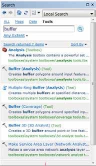
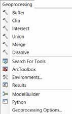
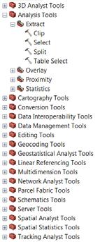
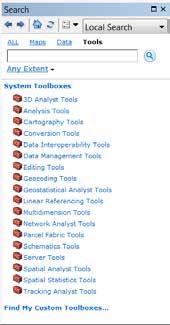
7 Finding Tools Catalog Search ArcToolbox Geoprocessing Menu
8 Types of Toolboxes System toolboxes - Installed with ArcGIS - Read-only Custom toolboxes - User created - Stored in a folder (.tbx file type) or a geodatabase Read-only Python toolboxes

9 Geoprocessing Options Geoprocessing Menu > Geoprocessing Options Default behaviors for geoprocessing Tips: Overwrite outputs Background Processing Keep results
10 Demo Model Example Esri UC2013. Technical Workshop.
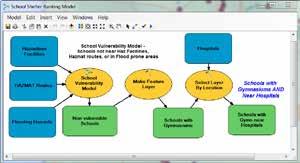
11 Workflow for Presentation Goal: Identify zones with inadequate fire hydrant coverage Problem: Some zones lack enough working fire hydrants - No zone should have more than 3 inoperable hydrants - Buildings should be within 250 feet of a fire hydrant - Identify unsafe zones - Identify buildings too far from a working hydrant Select inoperable hydrants Overlay with fire zones Buffer inoperable hydrants Select uncovered buildings
12 Getting Started with ModelBuilder Esri UC2013. Technical Workshop.

13 What is ModelBuilder? Tool for encapsulating workflows - Reusable - Sharable Why use ModelBuilder? - Automate and manage geoprocessing workflows - Run complex succession of processes as one tool - Plug in additional tools and parameters as needed - See a visual representation of analysis operations

14 Creating a New Model ModelBuilder button ArcMap Standard toolbar - Launches ModelBuilder with a new, unsaved model Inside a Custom toolbox - Right-click > New Model ModelBuilder button ArcMap Geoprocessing Menu - Launches ModelBuilder with a new, unsaved model

15 Model Properties Name - Cannot have spaces Label - How it appears in ArcToolbox - Can include spaces Description - Detailed information about the model - Good practice when sharing Relative Path - Good practice when sharing Open Model > Model Menu > Model Properties
16 Environment Settings Can be set at different levels Environments are passed down to tools and processes At each level, you can override the passed-down environment settings 1 Application Settings System wide defaults saved To geoprocessing settings If model runs within ModelBuilder 2 Tool Settings 3 Model Settings Temporarily overrides application settings Not saved anywhere If model runs as a tool Can override passed-down Settings, saved with model Model Process Settings Can override passed-down Settings, saved with model
17 Demo Creating a Model Esri UC2013. Technical Workshop.

18 Model Elements Three types of elements - Variables - Tools - Connectors
19 Adding Tools and Data to a Model Tools Data Variables Built-in Tool Script Tool Model Tool Input Data Derived Data Tools - Drag and drop from Catalog - Drag and drop from Search - Drag and drop from Toolbox - Use Add button in ModelBuilder - Use Insert menu in ModelBuilder Data - Drag and drop from TOC - Drag and drop from Catalog - Drag and drop from Search - Fill in dialog - Use Add button in ModelBuilder - Use Insert menu in ModelBuilder


20 Connecting Elements 1. Connect Tool 2. Tool Dialog Connect the input to the tool Browse to the data on disk OR Use the dropdown to choose a variable or a layer

21 Connect Tool Tip Enable Geoprocessing Menu > Geoprocessing Options > ModelBuilder to display valid parameters - By default, a list of valid parameters appears when connections are made
22 Derived Data is Created by Processes Existing Data Blue Ovals Derived Data Green Ovals Schools Buffer Schools_ Buffer Input Table Add Field Final Table In/Out Derived Data - Input will be altered/updated when the model is executed - Data will have the same name as the input data with a unique number appended at the end


23 Tool Parameters Inputs and outputs of a tool Required and Optional parameters - Required must be filled out before tool process can execute in the model Distance (required parameter) is not filled out; the tool is not ready to run yet and is empty colored
24 Model Process States Schools Buffer Schools_ Buffer Single Process Not ready-to-run Tool Derived Data Ready-to-run Input Data Tool Derived Data Has-been-run Input Data Tool Derived Data

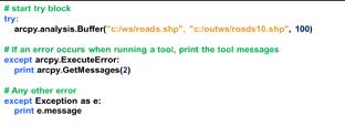
25 Validating Verifies all data elements and parameter values are valid Success: Returns model from Has-Been-Run to Ready-to-Run state Unsuccessful: Model elements may turn to Not-Ready-to-Run state
26 Creating Model Tools Esri UC2013. Technical Workshop.


27 Running a Model as a Tool Double-click tool or Right-click > Open a model from its toolbox opens the model tool dialog These ARE models: No parameters; click OK to run Parameters; populate required, click OK

28 Parameters Table Location Create Table Output Table P Model Parameter Parameters name becomes will have the a P parameter next label on to the them tool dialog Table Name Model Parameters will have a P next to them

29 Creating Variables from Tool Parameters ModelBuilder will create a variable for input and output datasets - You decide which tool arguments to expose as variables - Any variable can be made a model parameter Right-click on tool Make Variable > From Parameter - Then set variable as a model parameter
30 Demo Creating a Model Tool Esri UC2013. Technical Workshop.
31 Tips for Designing & Sharing Models Esri UC2013. Technical Workshop.

32 Intermediate Data Can think of Intermediate data as temporary scratch data All data variables except existing and final output are set to Intermediate by default Can determine where it is stored - Tip: Should not be set to an enterprise geodatabase Is not automatically deleted when run from ModelBuilder window - Manually delete from Model Menu > Delete Intermediate data


33 Model Tools in Other Models Models can be added to another model - Break down complex models into smaller, perhaps more manageable sub-processes - Collaborate with a team where domain experts can work on their model
34 Tips for Running Models Running models from ModelBuilder: - Intermediate data is not automatically deleted - Add to display enabled outputs are added to Map - No Background Geoprocessing always runs in foreground Running models from Model tool: - Intermediate data is deleted on completion - Only parameters are added to display - Option to run in foreground (Model menu > Model properties dialog) to disable/enable background geoprocessing
35 Design Models to be Sharable Flexible - Not data-dependent, good folder structure - Environments, Relative paths, etc.. - Parameters & variables - Read: A quick tour of sharing custom tools Clear and easy to read - Layout is simple and logical - Labels added for clarity - Elements renamed and not cryptic Documented - Item descriptions - Help documentation

36 Modifying the Layout ModelBuilder provides the ability to: - Arrange, reposition, and resize elements - Change the name of elements - Apply labels and other text - Change symbols of elements


37 Layout: Automatic vs. Manual Automatic Layout mode: - Enables Auto Layout button - Arranges model elements using settings under the Layout tab Manual Layout mode: - Disables Auto Layout button - Auto-arranging will not occur - This message appears:

38 Layout Options ModelBuilder window > Model Menu > Diagram Properties Orientation of processes, Spacing between elements/connectors, Connector styles Clicking Auto Layout button applies these options Default Settings


39 Documenting with Labels Element Labels Free Floating Labels Connector Labels


40 Pictures for Elements You can use graphic files for tool and variable elements Right click model elements > Switch to picture symbol
41 Demo Designing & Sharing Models Esri UC2013. Technical Workshop.

42 Learning More Esri UC2013. Technical Workshop.
43 ArcGIS Resource Center ArcGIS Online Help - Communities Analysis and Geoprocessing - Blogs - Videos - Forums -
44 Learning More at the Conference Geoprocessing with ArcGIS for Server - Wednesday 8:30AM 9:45AM, Room 04 - Thursday 1:30PM 2:45PM, Room 04 Geoprocessing: Real-World Examples of Spatial Analysis Models - Wednesday 11:00AM 12:00PM, Demo Theater Analysis & Geoprocessing Exhibit Hall B Geoprocessing: Sharing Workflows with Geoprocessing Packages - Tuesday 10:15AM 11:30AM, Room 15 B - Wednesday 3:15PM 4:30PM, Room 15 B And many more.

45 Learning More After the Conference Training Instructor-led, Web-based, and FREE Seminars Esri Press Books Getting to Know ArcGIS ModelBuilder - Covers topics from beginner to advanced
46 Thank you Please fill out the session evaluation First Offering ID: 1170 Second Offering ID: 1291 Online Paper pick up and put in drop box


47
Fundamentals of ModelBuilder
 Fundamentals of ModelBuilder Agenda An Overview of Geoprocessing Framework Introduction to ModelBuilder Basics of ArcToolbox Using ModelBuilder Documenting Models Sharing Models with Others Q & A Geoprocessing
AGENDA. Effective Geodatabase Management. Presentation Title. Using Automation. Mohsen Kamal. Name of Speaker Company Name
 AGENDA Effective Geodatabase Management Presentation Title Using Automation Mohsen Kamal Name of Speaker Company Name Agenda Introducing the geodatabase What is a Schema? Schema Creation Options Geoprocessing
Network Analyst: Automating Workflows with Geoprocessing
 Esri International User Conference San Diego, California Technical Workshops July 25, 2012 Network Analyst: Automating Workflows with Geoprocessing Deelesh Mandloi Patrick Stevens Introductions Who are
EDUCATION GIS CONFERENCE Geoprocessing with ArcGIS Pro. Rudy Prosser GISP CTT+ Instructor, Esri
 EDUCATION GIS CONFERENCE Geoprocessing with ArcGIS Pro Rudy Prosser GISP CTT+ Instructor, Esri Maintenance What is geoprocessing? Geoprocessing is - a framework and set of tools for processing geographic
Geocoding An Introduction
 2013 Esri International User Conference July 8 12, 2013 San Diego, California Technical Workshop Geocoding An Introduction Miriam Schmidts Agatha Wong Esri UC2013. Technical Workshop. Agenda What is geocoding?
An Introduction to Geoprocessing
 An Introduction to Geoprocessing 1 Geoprocessing What is Geoprocessing What are Geoprocessing Models 2 What is Geoprocessing? Geoprocessing is the processing of geographic information, one of the basic
Lab Assignment 5 Geoprocessing Service. Due Date: 01/24/2014
 Lab Assignment 5 Geoprocessing Service Due Date: 01/24/2014 Overview Geoprocessing is one of the original purposes or functions when GIS was invented. It provides tools and a framework for performing analysis
Analysis & Geoprocessing: Case Studies Problem Solving
 Analysis & Geoprocessing: Case Studies Problem Solving Shawn Marie Simpson Federal User Conference 2008 3 Overview Analysis & Geoprocessing Review What is it? How can I use it to answer questions? Case
Using the ModelBuilder of ArcGIS 9 for Landscape Modeling
 Using the ModelBuilder of ArcGIS 9 for Landscape Modeling Jochen MANEGOLD, ESRI-Germany Geoprocessing in GIS A geographic information system (GIS) provides a framework to support planning tasks and decisions,
UNIGIS University of Salzburg. Module: ArcGIS for Server Lesson: Online Spatial analysis UNIGIS
 1 Upon the completion of this presentation you should be able to: Describe the geoprocessing service capabilities Define supported data types input and output of geoprocessing service Configure a geoprocessing
ArcGIS Pro: Scripting with Python. John Jennifer Duerr:
 ArcGIS Pro: Scripting with Python John Yaist: jyaist@esri.com @TheMaphaps Jennifer Duerr: jduerr@esri.com Target Audience Experienced ArcGIS Desktop Users Experienced with Python Scripting Curious about
ARC HYDRO GROUNDWATER TUTORIALS
 ARC HYDRO GROUNDWATER TUTORIALS Subsurface Analyst Creating ArcMap cross sections from existing cross section images Arc Hydro Groundwater (AHGW) is a geodatabase design for representing groundwater datasets
Street Canyon Tool. User Guide CERC
 Street Canyon Tool User Guide CERC ADMS Street Canyon Tool Version 2.0 User Guide August 2018 Cambridge Environmental Research Consultants Ltd. 3, King s Parade Cambridge CB2 1SJ UK Telephone: +44 (0)1223
Geography 281 Map Making with GIS Project Ten: Mapping and Spatial Analysis
 Geography 281 Map Making with GIS Project Ten: Mapping and Spatial Analysis This project introduces three techniques that enable you to manipulate the spatial boundaries of geographic features: Clipping
Objectives Learn how to import and display shapefiles in GMS. Learn how to convert the shapefiles to GMS feature objects. Required Components
 v. 10.3 GMS 10.3 Tutorial Importing, displaying, and converting shapefiles Objectives Learn how to import and display shapefiles in GMS. Learn how to convert the shapefiles to GMS feature objects. Prerequisite
Analysis and Geoprocessing Sessions and Demo Theater Presentations
 Esri User Conference 2018 Analysis and Geoprocessing Sessions and Demo Theater Presentations TUESDAY 7/10 -------------------------------------------------------------------------------------------------------------------------------------------
Packaging Projects, Maps and Layers. Shilpi Jain Melanie Summers
 Packaging Projects, Maps and Layers Shilpi Jain Melanie Summers What can be packaged Layer Map Project Layer package (.lypkx) Tile package (.tpk) Scene layer package (.slpk) Map package (.mpkx) Mobile
How to put the Image Services in the Living Atlas to Work in Your GIS. Charlie Frye, Chief Cartographer Esri, Redlands
 How to put the Image Services in the Living Atlas to Work in Your GIS Charlie Frye, Chief Cartographer Esri, Redlands Image Services in the Living Atlas of the World Let s have a look: https://livingatlas.arcgis.com
ArcGIS Pro: Tips & Tricks
 ArcGIS Pro: Tips & Tricks James Sullivan Solution Engineer Agenda Project Structure/Set Up Data Visualization/Map Authoring Data/Map Exploration Geoprocessing Editing Layouts Sharing Working with the Ribbon
Provides the data analysis, management and
 Leveraging g the Geoprocessing Framework in ArcGIS Engine in.net (Best Practices) Jason Pardy Corey Tucker UC 2006 Tech Session 1 Workshop Outline What is Geoprocessing Accessing and Running Geoprocessing
Spatial Analysis with ArcGIS Pro. Krithica Kantharaj, Esri
 Spatial Analysis with ArcGIS Pro Krithica Kantharaj, Esri What is analysis? Analysis transforms raw data into information or knowledge Spatial analysis does this for geographic or spatial data Who? What?
ArcGIS Pro: What s New in Analysis
 Federal GIS Conference February 9 10, 2015 Washington, DC ArcGIS Pro: What s New in Analysis James Sullivan What is analysis? Analysis transforms raw data into information or knowledge. Spatial analysis
ArcGIS Pro: What s New in Analysis. Rob Elkins
 ArcGIS Pro: What s New in Analysis Rob Elkins ArcGIS Pro Welcome ArcGIS Pro: Analysis Rob Elkins ArcGIS Pro 1.0 Now Available = + Includes the complete ArcGIS Platform Application fusion Single, always
ArcGIS Tutorial: Geocoding Addresses
 U ArcGIS Tutorial: Geocoding Addresses Introduction Address data can be applied to a variety of research questions using GIS. Once imported into a GIS, you can spatially display the address locations and
Creating Geoprocessing Services
 Esri International User Conference San Diego, California Technical Workshops July 25, 2012 Creating Geoprocessing Services Kevin Hibma, Scott Murray Analysis and Geoprocessing Resource Center Quick Links:
ArcGIS Runtime: Analysis. Lucas Danzinger Mark Baird Mike Branscomb
 ArcGIS Runtime: Analysis Lucas Danzinger Mark Baird Mike Branscomb ArcGIS Runtime session tracks at DevSummit 2018 ArcGIS Runtime SDKs share a common core, architecture and design Functional sessions promote
Watershed Sciences 4930 & 6920 GEOGRAPHIC INFORMATION SYSTEMS
 Slides by Wheaton et al. (2009-2014) are licensed under a Creative Commons Attribution-NonCommercial-ShareAlike 3.0 Unported License Watershed Sciences 4930 & 6920 GEOGRAPHIC INFORMATION SYSTEMS INTRODUCTION
Objectives Learn how to import and display shapefiles with and without ArcObjects. Learn how to convert the shapefiles to GMS feature objects.
 v. 10.1 GMS 10.1 Tutorial Importing, displaying, and converting shapefiles Objectives Learn how to import and display shapefiles with and without ArcObjects. Learn how to convert the shapefiles to GMS
SCHEDULE USER GUIDE. Version Noventri Suite Schedule User Guide SF100E REV 08
 SCHEDULE USER GUIDE Version 2.0 1 Noventri Suite Schedule User Guide SF100E-0162-02 REV 08 Table of Contents 1. SCHEDULE... 3 1.1 Overview... 3 1.2 Start SCHEDULE... 3 1.3 Select Project... 4 1.4 Select
Getting Started Guide
 SOLIDWORKS Getting Started Guide SOLIDWORKS Electrical FIRST Robotics Edition Alexander Ouellet 1/2/2015 Table of Contents INTRODUCTION... 1 What is SOLIDWORKS Electrical?... Error! Bookmark not defined.
THE LIST USABILITY PUG 2007
 THE LIST USABILITY PUG 2007 Layer/Map Management Working with many layers, maps and data sets Direction that ESRI is taking with the Geodatabase Information Model Direction that ESRI is taking with GIS
ArcGIS 9 Using ArcGIS StreetMap
 ArcGIS 9 Using ArcGIS StreetMap Copyright 2001 2004 ESRI All Rights Reserved. Printed in the United States of America. The information contained in this document is the exclusive property of ESRI. This
Getting Started with. Vectorworks Architect
 Getting Started with Vectorworks Architect Table of Contents Introduction...2 Section 1: Program Installation and Setup...6 Installing the Vectorworks Architect Program...6 Exercise 1: Launching the Program
GIS Module GMS 7.0 TUTORIALS. 1 Introduction. 1.1 Contents
 GMS 7.0 TUTORIALS 1 Introduction The GIS module can be used to display data from a GIS database directly in GMS without having to convert that data to GMS data types. Native GMS data such as grids and
Submittals Quick Reference Guide
 This topic provides a reference for the Project Center Submittals activity center. Purpose The Submittals activity center in Newforma Contract Management enables you to effectively log submittals and track
Presentation Skills Workshop
 Presentation Skills Workshop Rudy Prosser GISP CTT+ Instructor, Esri Keera Morrish CTT+ Instructor, Esri No interaction Left the session Confident Engaged Read from the slide Waste of time Dynamic Interested
v. 8.0 GMS 8.0 Tutorial GIS Module Shapefile import, display, and conversion Prerequisite Tutorials None Time minutes
 v. 8.0 GMS 8.0 Tutorial Shapefile import, display, and conversion Objectives Learn how to import and display shapefiles with and without ArcObjects. Convert the shapefiles to GMS feature objects. Prerequisite
uiulearn TUTORIAL INTEGRATIONS> HOW TO USE PANOPTO (STUDENT)
") uiulearn TUTORIAL INTEGRATIONS> HOW TO USE PANOPTO (STUDENT) This tutorial covers how to record a Panopto video for your course. IN ORDER TO DO THIS, YOUR INSTRUCTOR MUST COMPLETE SEVERAL STEPS TO ALLOW
uiulearn TUTORIAL INTEGRATIONS> HOW TO USE PANOPTO (STUDENT) This tutorial covers how to record a Panopto video for your course. IN ORDER TO DO THIS, YOUR INSTRUCTOR MUST COMPLETE SEVERAL STEPS TO ALLOW
Basics Pictures Media Bar
 Basics 1 The right pictures can make your publication stand out from the crowd. In this tutorial, we ll show you how to: Add and replace pictures. Use the Media Bar. Pan, zoom, and crop pictures. Apply
Building Java Apps with ArcGIS Runtime SDK
 Building Java Apps with ArcGIS Runtime SDK Vijay Gandhi, Elise Acheson, Eric Bader Demo Source code: https://github.com/esri/arcgis-runtime-samples-java/tree/master/devsummit-2014 Video Recording: http://video.esri.com
Using Dynamic Views. Module Overview. Module Prerequisites. Module Objectives
 Using Dynamic Views Module Overview The term dynamic views refers to a method of composing drawings that is a new approach to managing projects. Dynamic views can help you to: automate sheet creation;
AutoCAD Civil 3D 2009 ESSENTIALS
 AutoCAD Civil 3D 2009 ESSENTIALS SDC PUBLICATIONS Schroff Development Corporation www.schroff.com Better Textbooks. Lower Prices. Alignments and Profiles Section 2: Profiles In this section you learn how
Map Direct Lite. Contents. Quick Start Guide: Drawing 11/05/2015
 Map Direct Lite Quick Start Guide: Drawing 11/05/2015 Contents Quick Start Guide: Drawing... 1 Drawing, Measuring and Analyzing in Map Direct Lite.... 2 Measure Distance and Area.... 3 Place the Map Marker
Celtx Studios Owner's Manual January 2011
 January 2011 Get the most out of Celtx Studios with the latest version of Celtx - available free at http://celtx.com Screen captures are made using Windows OS. Some image dialogs differ slightly on Mac
Photoshop: a Beginner s course. by: Charina Ong Centre for Development of Teaching and Learning National University of Singapore
 Photoshop: a Beginner s course by: Charina Ong Centre for Development of Teaching and Learning National University of Singapore Table of Contents About the Workshop... 1 Prerequisites... 1 Workshop Objectives...
Qt Developing ArcGIS Runtime Applications. Eric
 Qt Developing ArcGIS Runtime Applications Eric Bader @ECBader Agenda Getting Started Creating the Map Geocoding and Routing Geoprocessing Message Processing Working Offline The Next Release What s Coming
GEOGRAPHIC MODELLING AND ANALYSIS
 GEOGRAPHIC MODELLING AND ANALYSIS I. INTRODUCTION A. Background Geographic Information System is organized within a GIS so as to optimize the convenience and efficiency with they can be used. To distinguish
Exercise 1: The AutoCAD Civil 3D Environment
 Exercise 1: The AutoCAD Civil 3D Environment AutoCAD Civil 3D Interface Object Base Layer Object Component Layers 1-1 Introduction to Commercial Site Grading Plans AutoCAD Civil 3D Interface AutoCAD Civil
Kodiak Corporate Administration Tool
 AT&T Business Mobility Kodiak Corporate Administration Tool User Guide Release 8.3 Table of Contents Introduction and Key Features 2 Getting Started 2 Navigate the Corporate Administration Tool 2 Manage
in ArcMap By Mike Price, Entrada/San Juan, Inc.
 Interactively Create and Apply Logarithmic Legends in ArcMap By Mike Price, Entrada/San Juan, Inc. This exercise uses the dataset for Battle Mountain, Nevada, that was used in previous exercises. The Geochemistry
Esri UC 2014 Technical Workshop
 Introduction to Parcel Fabric Amir Plans Parcels Control 1 Points 1-1 Line Points - Lines Editing and Maintaining Parcels using Deed Drafter and ArcGIS Desktop What is a parcel fabric? Dataset of related
Batch Processing Converting images in a folder to JPEG
 Batch Processing Converting images in a folder to JPEG Request I would like to convert multiple RAW images (NEF files) to JPEG images all at once Response You can use a Batch Process to convert all RAW
Autodesk Advance Steel. Drawing Style Manager s guide
 Autodesk Advance Steel Drawing Style Manager s guide TABLE OF CONTENTS Chapter 1 Introduction... 5 Details and Detail Views... 6 Drawing Styles... 6 Drawing Style Manager... 8 Accessing the Drawing Style
ACCU-GOLD QUICK START MANUAL
 ACCU-GOLD Now includes support for the light sensor (AGLS) and Accu Gold+ digitizers and sensors (AGDM+, AGMS DM+) Nomenclature AGDM Accu-Gold Digitizer Module RGDM Rapid-Gold Digitizer Module RGDM-MA
CAD Tutorial. CAD Detail Windows. In this tutorial you ll learn about: CAD Detail Windows Exploding and Modifying a CAD Block
 CAD Tutorial In this tutorial you ll learn about: CAD Detail Windows Exploding and Modifying a CAD Block Creating a New CAD Block CAD Detail from View Creating a Plot Plan CAD Detail Windows CAD Details
Introduction to Parametric Modeling AEROPLANE. Design & Communication Graphics 1
 AEROPLANE Design & Communication Graphics 1 Object Analysis sheet Design & Communication Graphics 2 Aeroplane Assembly The part files for this assembly are saved in the folder titled Aeroplane. Open an
Advance Steel. Drawing Style Manager s guide
 Advance Steel Drawing Style Manager s guide TABLE OF CONTENTS Chapter 1 Introduction...7 Details and Detail Views...8 Drawing Styles...8 Drawing Style Manager...9 Accessing the Drawing Style Manager...9
Getting Started with. Vectorworks Architect
 Getting Started with Vectorworks Architect Table of Contents Introduction...2 Section 1: Program Installation and Setup...6 Installing the Vectorworks Architect Program...6 Exercise 1: Launching the Program
Portrait Pro User Manual
 Portrait Pro User Manual Version 17.0 Anthropics Technology Ltd www.portraitpro.com Contents 3 Table of Contents Part I Getting Started 6 1 Quick Start... Guide 7 2 Top Tips... For Best Results 8 3 Portrait...
Sheet Metal Punch ifeatures
 Lesson 5 Sheet Metal Punch ifeatures Overview This lesson describes punch ifeatures and their use in sheet metal parts. You use punch ifeatures to simplify the creation of common and specialty cut and
NIS-Elements: Grid to ND Set Up Interface
 NIS-Elements: Grid to ND Set Up Interface This document specifies the set up details of the Grid to ND macro, which is included in material # 97157 High Content Acq. Tools. This documentation assumes some
GEO/EVS 425/525 Unit 2 Composing a Map in Final Form
 GEO/EVS 425/525 Unit 2 Composing a Map in Final Form The Map Composer is the main mechanism by which the final drafts of images are sent to the printer. Its use requires that images be readable within
Hyperion System 9 Financial Data Quality Management
 Hyperion System 9 Financial Data Quality Management Administrator Training Guide WebLink Version 8.3, 8.31, and Hyperion System 9 Financial Data Quality Management Version 9.2.0 Hyperion Financial Management
User Manual. Presented by The Knit Foundry: building better tools for knitters. Copyright 2005, 2006 The Knit Foundry
 Knit Visualizer 1.2 Manual Page 1 of 46 User Manual Presented by The Knit Foundry: building better tools for knitters Knit Visualizer 1.2 Manual Page 2 of 46 WHAT IS KNIT VISUALIZER? ----------------------------------------------------------------------------------------------
RAVASMARTSOLUTIONS - TECH TIPS
 Purpose RAVASMARTSOLUTIONS - TECH TIPS CS5 - Flash - Build an Image Library This Tech Tip will illustrate how to build an image library in Flash. This will allow you to have a lot of Flash Graphics available
Working with Detail Components and Managing DetailsChapter1:
 Chapter 1 Working with Detail Components and Managing DetailsChapter1: In this chapter, you learn how to use a combination of sketch lines, imported CAD drawings, and predrawn 2D details to create 2D detail
Welcome to Storyist. The Novel Template This template provides a starting point for a novel manuscript and includes:
 Welcome to Storyist Storyist is a powerful writing environment for ipad that lets you create, revise, and review your work wherever inspiration strikes. Creating a New Project When you first launch Storyist,
ArcGIS Online Content
 Esri International User Conference San Diego, California Technical Workshops July 25, 2012 ArcGIS Online Content Deane Kensok Sarah Osborne Today s Agenda Overview Esri Content Portfolio - What s Available,
CBCL Limited Sheet Set Manager Tutorial 2013 REV. 02. CBCL Design Management & Best CAD Practices. Our Vision
 CBCL Limited Sheet Set Manager Tutorial CBCL Design Management & Best CAD Practices 2013 REV. 02 Our Vision To be the most respected and successful Atlantic Canada based employeeowned firm, delivering
AreaSketch Pro Overview for ClickForms Users
 AreaSketch Pro Overview for ClickForms Users Designed for Real Property Specialist Designed specifically for field professionals required to draw an accurate sketch and calculate the area and perimeter
White paper brief IdahoView Imagery Services: LISA 1 Technical Report no. 2 Setup and Use Tutorial
 White paper brief IdahoView Imagery Services: LISA 1 Technical Report no. 2 Setup and Use Tutorial Keith T. Weber, GISP, GIS Director, Idaho State University, 921 S. 8th Ave., stop 8104, Pocatello, ID
Section 1. Introduction and Review. Objectives: Log on to the computer Launch AutoCAD Create, open, and save a drawing Review AutoCAD basics
 Section 1 Introduction and Review Objectives: Log on to the computer Launch AutoCAD Create, open, and save a drawing Review AutoCAD basics Drawing Assignments: NCAA Basketball Court Plot Style Table (Check-off)
Geometry Controls and Report
 Geometry Controls and Report 2014 InnovMetric Software Inc. All rights reserved. Reproduction in part or in whole in any way without permission from InnovMetric Software is strictly prohibited except for
House Design Tutorial
 Chapter 2: House Design Tutorial This House Design Tutorial shows you how to get started on a design project. The tutorials that follow continue with the same plan. When we are finished, we will have created
AutoCAD 2020 Fundamentals
 Autodesk AutoCAD 2020 Fundamentals ELISE MOSS Autodesk Certified Instructor SDC PUBLICATIONS Better Textbooks. Lower Prices. www.sdcpublications.com Powered by TCPDF (www.tcpdf.org) Visit the following
Finance Manager: Accounting
 : Accounting Online Purchasing Within the Computer PO and Requisition Entry processes, the Online Purchasing feature allows the user to access a vendor website; search for, select, and place items in a
MC3 Motion Control System Shutter Stream Quickstart
 MC3 Motion Control System Shutter Stream Quickstart Revised 7/6/2016 Carousel USA 6370 N. Irwindale Rd. Irwindale, CA 91702 www.carousel-usa.com Proprietary Information Carousel USA has proprietary rights
Chapter 16: Batch Scanning
 Chapter 16: Batch Scanning The Batch Scanning module allows users to scan and upload various versions of voter registration forms as a batch into the system. Once they are scanned, documents are available
Quick Start for Autodesk Inventor
 Quick Start for Autodesk Inventor Autodesk Inventor Professional is a 3D mechanical design tool with powerful solid modeling capabilities and an intuitive interface. In this lesson, you use a typical workflow
That CAD Girl. J ennifer dib ona. Land Desktop Project Management. Website:
 That CAD Girl J ennifer dib ona Website: www.thatcadgirl.com Email: thatcadgirl@aol.com Phone: (919) 417-8351 Fax: (919) 573-0351 Land Desktop Project Management When working in Land Desktop you are required
Annex IV - Stencyl Tutorial
 Annex IV - Stencyl Tutorial This short, hands-on tutorial will walk you through the steps needed to create a simple platformer using premade content, so that you can become familiar with the main parts
Welcome. Camera & GPS Set-up
 Table of Contents Camera & GPS Set-up... 1 Initializing the GPS...2 Compass/Heading...2 Distance...3 Tips to get the most out of your Camera...3 GPS-Photo Link Setup: Registration...3 Program Screens...
Kitchen and Bath Design Tutorial
 Kitchen and Bath Design Tutorial This tutorial continues where the Interior Design Tutorial left off. You should save this tutorial using a new name to archive your previous work. The tools and techniques
iphoto Getting Started Get to know iphoto and learn how to import and organize your photos, and create a photo slideshow and book.
 iphoto Getting Started Get to know iphoto and learn how to import and organize your photos, and create a photo slideshow and book. 1 Contents Chapter 1 3 Welcome to iphoto 3 What You ll Learn 4 Before
AS How to Use Dynamo to Visibly Show Navisworks Clashes into Revit
 AS125109 How to Use Dynamo to Visibly Show Navisworks Clashes into Revit Felix Tan Stantec Ryan Wells Stantec Learning Objectives Learn how to simplify a coordination workflow between Navisworks and Revit
Photoshop CS2. Step by Step Instructions Using Layers. Adobe. About Layers:
 About Layers: Layers allow you to work on one element of an image without disturbing the others. Think of layers as sheets of acetate stacked one on top of the other. You can see through transparent areas
Rapid Airfield Construction Decision Support Toolset
 Rapid Airfield Construction Decision Support Toolset Scott Bourne ERDC Scott.Bourne@erdc.usace.army.mil 601-634-3980 Introduction One of the greatest challenges to the U.S. Army s Rapid Deployment concept
Autodesk Inventor Drawing Manager Tips & Tricks
 Alessandro Gasso Autodesk, Inc. MA1280 This class covers several workflows that answer the most common questions from the Inventor users about the Drawing Manager. You will learn how to add the scale value
Appendix R5 6. Engineering Drafting. Broken View
 Updating Using Autodesk Inventor to Release 5 Appendix R5 6 Engineering Drafting Chapter 6 delineates the concepts of engineering drafting. You output orthographic views from solid parts and orthographic
Solving tasks and move score... 18
 Solving tasks and move score... 18 Contents Contents... 1 Introduction... 3 Welcome to Peshk@!... 3 System requirements... 3 Software installation... 4 Technical support service... 4 User interface...
A Quick Spin on Autodesk Revit Building
 11/28/2005-3:00 pm - 4:30 pm Room:Americas Seminar [Lab] (Dolphin) Walt Disney World Swan and Dolphin Resort Orlando, Florida A Quick Spin on Autodesk Revit Building Amy Fietkau - Autodesk and John Jansen;
5 Masks and Channels
 5 Masks and Channels Adobe Photoshop uses masks to isolate and manipulate specific parts of an image. A mask is like a stencil. The cutout portion of the mask can be altered, but the area surrounding the
Document history Date Doc version Ifx version Editor Change
 Document history Date Doc version Ifx version Editor Change Jan 2008 2 5.21.0300 HV Nov 2015 2.1 5.60.0400 JW Update for 5.60.0400 Inclusion of Epiphan Image Capture Nov 2017 2.2 5.70.0100 JW Update for
This document contains work instructions related to utilizing the dental imaging application, XrayVision DCV, version and above.
 Apteryx Inc. 313 S. High St. Suite 200 Akron, OH 44308 330-376-0889 voice 330-376-0788 fax sales@apteryx.com www.apteryx.com XRAYVISION DCV User Guide Abstract Abstract This document contains work instructions
Estimated Time Required to Complete: 45 minutes
 Estimated Time Required to Complete: 45 minutes This is the first in a series of incremental skill building exercises which explore sheet metal punch ifeatures. Subsequent exercises will address: placing
Table of Contents. Creating Your First Project 4. Enhancing Your Slides 8. Adding Interactivity 12. Recording a Software Simulation 19
 Table of Contents Creating Your First Project 4 Enhancing Your Slides 8 Adding Interactivity 12 Recording a Software Simulation 19 Inserting a Quiz 24 Publishing Your Course 32 More Great Features to Learn
Minolta Scanner Plugin
 Minolta Scanner Plugin For a list of Minolta digitizers and Geomagic software products with which this plugin is compatible, see Release Notes for Geomagic Minolta Plugin 7.6.0.3. Copyright 2005, Raindrop
GL Workflow: Dept. to Project/Grant Expense Transfer
 FMSv9.1 GL Workflow: Dept. to Project/Grant Expense Transfer Procedure Journal Entries are created to charge an expense to a Department(s) and or Project/Grant that agreed to share in the costs associated
MY BERNINA EMBROIDERY MASTERY BOOK SERIES SOFTWARE BERNINA EMBROIDERY SOFTWARE 8.1. WORKBOOK 4 Application Programs
 MY BERNINA EMBROIDERY MASTERY BOOK SERIES SOFTWARE BERNINA EMBROIDERY SOFTWARE 8.1 WORKBOOK 4 Application Programs 2017 BERNINA of America. 02/012017 Table of Contents Introduction... 3 Exercises Quilter...
From Nothing to Something using AutoCAD Electrical
 From Nothing to Something using AutoCAD Electrical Todd Schmoock Synergis Technologies MA2085-L: You purchased AutoCAD Electrical, or are thinking about purchasing it, but you do not know how to use it.