GLOBAL POSITIONING SYSTEMS
|
|
|
- Gladys Tate
- 5 years ago
- Views:
Transcription

1 GLOBAL POSITIONING SYSTEMS Maps & Geospatial Concepts Fall 2015
2 Before GPS Historical look at navigation
3

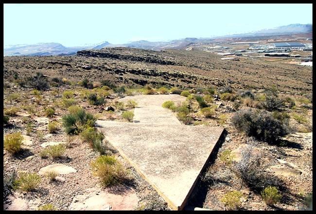
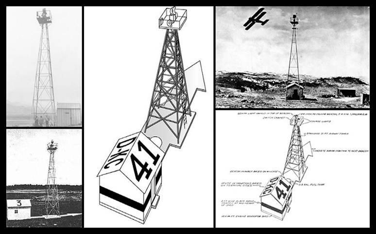
4 Giant concrete arrows that point your way across America

5 What are these giant arrows? Some kind of surveying mark? Landing beacons for flying saucers? Earth's turn signals?
6 Transcontinental Air Route
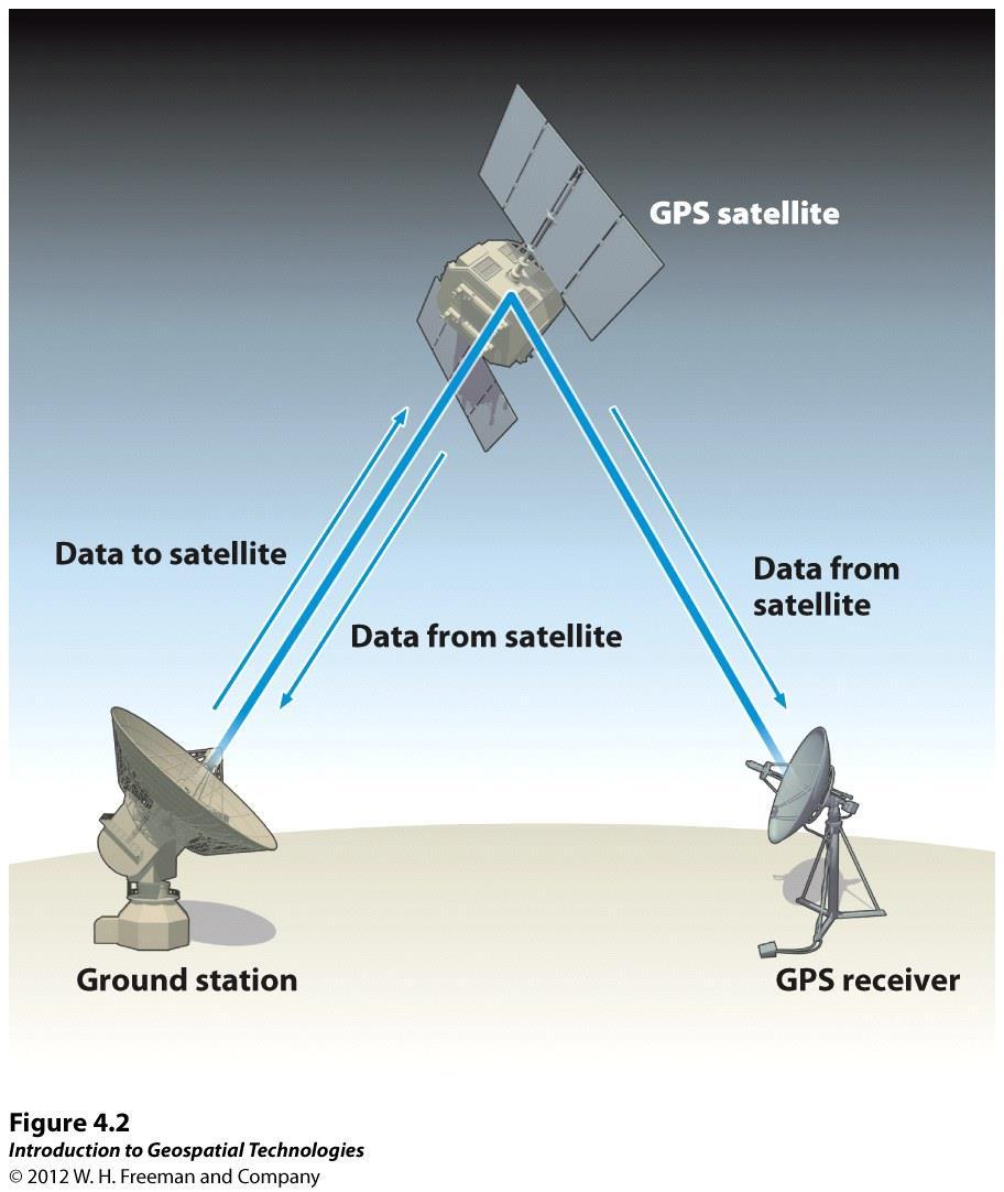
7 Transcontinental Air Route In 1920, the US opened its first coast-to-coast airmail delivery route No good aviation charts existed - pilots used landmarks to fly across the US. Solution: World's first ground-based civilian navigation system - a series of lit beacons from New York to San Francisco. a bright yellow concrete arrow every ten miles Each arrow would be surmounted by a 51-foot steel tower and lit by a million-candlepower rotating beacon.
8 Transcontinental Air Route
9 Mail could get from the Atlantic to the Pacific in just 30 hours or so. By 1929 it spanned the continent uninterrupted Advances in technology made these obsolete by the 1940 s, but the arrows still remain!
10 GPS: the beginning
 Created by the US gov t (GLONASS Russian equivalent) Allows a person to determine their location")
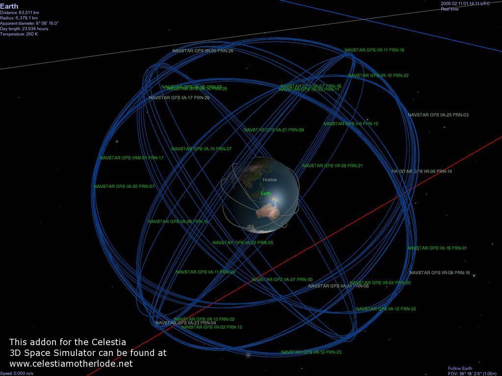
11 NAVSTAR NAVigation System with Time And Ranging 24 to 32 satellites orbiting the Earth Interchangeable with Global Positioning System (GPS) Created by the US gov t (GLONASS Russian equivalent) Allows a person to determine their location on Earth

12 Satellites Space First satellite launched in 1978 All satellites were broadcasting by satellites are required for a full constellation Orbits at about12,500 miles above the Earth s surface Single revolution takes about 12 hours
13
14 Satellites - Controls System of ground stations that track signals from satellites Corrections & new data are uploaded to satellites
15

16 Satellites - User GPS Receivers An antenna Electronics to receive satellite signals Microcomputer to process data that determines position Controls to provide user input Screen to display info
17 Determining Position 1 Satellite: places you somewhere on a spherical surface that's centered around the satellite 2 Satellites: places you somewhere along a circle that's between the two satellites 3 Satellites: usually intersect at two points, one of which will be on Earth's surface 4 Satellites: will intersect at just one point Adopted from:
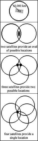
18 Source
19 Trilateration Using 3 points of reference to determine your location 3D Trilateration Same concept, with issues Atomic clock v. GPS receiver clock Needs a fourth satellite to compensate
20 GPS Accuracy Until May 2, 2000 the DoD deliberately corrupted GPS signals to create a random error anywhere up to 100m (selective availability) Most receivers have an accuracy between 1-20m Survey-grade GPS can be within 1cm
21 GPS Accuracy PDOP Position Dilution of Precision Error introduced with poor geometric arrangement of satellites The further the satellites are spread out the more accurate the point obtained by the receiver Atmospheric interference Multipath effects
 Under heavy tree canopy")
 Near powerful radio")
22 GPS Limitations Inside buildings Underground Severe precipitation (cloud cover) Under heavy tree canopy Around strong radio transmissions Urban Canyons (amongst tall buildings) Near powerful radio transmitter antennas
23 Differential Correction used to enhance the quality of location data gathered using GPS can be applied in the field or in post processing both methods are based on the same concepts, but each accesses different data sources and achieves different levels of accuracy
24 Field: WAAS Enabled Wide Area Augmentation System: uses a network of ground-based stations that compare their precisely known location with locations calculated from GPS satellite signals. Any differences found can be used to create correction data that's broadcast from WAAS satellites Adopted from:
25 Post Processing uses a base GPS receiver that logs positions at a known location and your field data (GPS receiver) data from the base and field are brought into a processing software, which computes corrected positions for the field data Trimble Software: GPS Pathfinder, GPS Analyst
26 Other GPS Systems GLONASS Russia s version of GPS In 2001, only a few satellites were still in orbit In 2007, civilian signal is made freely available Full constellation was restored for global coverage in 2011 Galileo EU s version of GPS Still in development (full deployment by 2020) Plans to have 30 satellite constellation 4 types of signals Beidou China s regional GPS system In development to be global by 2020 France, India, Japan all developing regional systems
27 Applications of GPS

28 Agriculture Precision agriculture or site-specific farming A tractor that plows fields by itself using GPS Farm planning, field mapping, soil sampling, tractor guidance, crop scouting, variable rate applications, and yield mapping.

29 Aviation Increased safety and efficiency of flight Departure, en route, arrival, and airport surface navigation An airplane that lands itself using GPS

30 Environment Data collection Tracking a species of animal using GPS GPS receivers mounted on buoys track the movement and spread of oil spills Helicopters use GPS to map the perimeter of forest fires and allow efficient use of fire fighting resources GPS is playing an increasingly prominent role in helping scientists to anticipate earthquakes Integration with GIS data to better understand a particular situation
31 Marine Search and rescue fastest and most accurate method for mariners to navigate, measure speed, and determine location Marine navigation position while in open sea, harbors and waterways. accurate position, speed, and heading Mariners and oceanographers underwater surveying, buoy placement, and navigational hazard location and mapping. Commercial fishing fleets navigate to optimum fishing locations, track fish migrations, and ensure compliance with regulations.
32 Public Safety & Disaster Relief Search and rescue create maps of the disaster areas for rescue and aid operations, assess damage Wildfire Management contain and manage forest fires, aircraft, identify fire boundaries and "hot spots" fire maps are transmitted to a portable field computer at the firefighters' camp Earthquakes scientists can study how strain builds up slowly over time in an attempt to characterize and (maybe) anticipate earthquakes Meteorologists storm tracking and flood prediction assess water vapor content by analyzing transmissions of GPS data through the atmosphere. Emergency response systems helping stranded motorists find assistance or guiding emergency vehicles. GPS in mobile phones & cars increases emergency location capability

33 Transportation Taxi, public transportation, trains keep transit vehicles on schedule and inform passengers of precise arrival times In time-definite delivery Trucking companies use GPS for tracking to guarantee delivery and pickup Navigation
34 Recreation Outdoor activities A hiker who loses her way and returns to safety using GPS Biking, fishing, golfing, aviation, boating, skiing A person using their smart phone app to find a place to eat, nearby Navigating drivers, pedestrians, bike riders
35 Recreation - Geocaching What is Geocaching? a real-world, outdoor treasure hunting game using GPS-enabled devices participants navigate to a specific set of GPS coordinates and then attempt to find the geocache (container) hidden at that location (geocaching.com)

36 Space Navigation solutions providing high precision orbit determination Timing solutions low-cost, precise time GPS receivers Constellation control provides single point-of-contact to control for the orbit maintenance of large numbers of space vehicles such as telecommunication satellites Formation flying allowing precision satellite formations Launch vehicle tracking range safety and autonomous flight termination. A space shuttle that navigates by itself using GPS
37 Timing Each GPS satellite contains multiple atomic clocks that contribute very precise time data to the GPS signals GPS receivers decode these signals, effectively synchronizing each receiver to the atomic clocks enables users to determine the time to within 100 billionths of a second
38 The GPS Crutch
39 News Story, 2009 Swedish couple driving from Venice to Capri Misspelled their destination and drove to a industrial northern town of Carpi a few hours later 10 minutes with a map would have let them know that: You can t make a 400 mile drive in two hours Capri is SE of Venice, not west Capri is a small island and they never crossed a bridge or got on a boat
40
GLOBAL POSITIONING SYSTEMS
 GLOBAL POSITIONING SYSTEMS GPS & GIS Fall 2017 Global Positioning Systems GPS is a general term for the navigation system consisting of 24-32 satellites orbiting the Earth, broadcasting data that allows
GE 113 REMOTE SENSING
 GE 113 REMOTE SENSING Topic 9. Introduction to Global Positioning Systems (GPS) and Other GNSS Technologies Lecturer: Engr. Jojene R. Santillan jrsantillan@carsu.edu.ph Division of Geodetic Engineering
What is a GPS How does GPS work? GPS Segments GPS P osition Position Position Accuracy Accuracy Accuracy GPS A pplications Applications Applications
 What is GPS? What is a GPS How does GPS work? GPS Segments GPS Position Accuracy GPS Applications What is GPS? The Global Positioning System (GPS) is a precise worldwide radio-navigation system, and consists
GLOBAL POSITIONING SYSTEMS. Knowing where and when
 GLOBAL POSITIONING SYSTEMS Knowing where and when Overview Continuous position fixes Worldwide coverage Latitude/Longitude/Height Centimeter accuracy Accurate time Feasibility studies begun in 1960 s.
Introduction to Geographic Information Science. Last Lecture. Today s Outline. Geography 4103 / GNSS/GPS Technology
 Geography 4103 / 5103 Introduction to Geographic Information Science GNSS/GPS Technology Last Lecture Geoids Ellipsoid Datum Projection Basics Today s Outline GNSS technology How satellite based navigation
Introduction to NAVSTAR GPS
 Introduction to NAVSTAR GPS Charlie Leonard, 1999 (revised 2001, 2002) The History of GPS Feasibility studies begun in 1960 s. Pentagon appropriates funding in 1973. First satellite launched in 1978. System
GBAS FOR ATCO. June 2017
 GBAS FOR ATCO June 2017 Disclaimer This presentation is for information purposes only. It should not be relied on as the sole source of information, and should always be used in the context of other authoritative
Introduction to the Global Positioning System
 GPS for Fire Management - 2004 Introduction to the Global Positioning System Pre-Work Pre-Work Objectives Describe at least three sources of GPS signal error, and identify ways to mitigate or reduce those
What is GPS? GPS Position Accuracy. GPS Applications. What is a GPS. How does GPS work? GPS Segments
 What is GPS? What is a GPS How does GPS work? GPS Segments GPS Position Accuracy GPS Applications 1 What is GPS? The Global Positioning System (GPS) is a precise worldwide radio-navigation system, and
Global Positioning Systems (GPS) Trails: the achilles heel of mapping from the air / satellites
 Trails: the achilles heel of mapping from the air / satellites") Global Positioning Systems (GPS) Trails: the achilles heel of mapping from the air / satellites Google maps updated regularly by local users using GPS Also: http://openstreetmaps.org GPS applications
Global Positioning Systems (GPS) Trails: the achilles heel of mapping from the air / satellites Google maps updated regularly by local users using GPS Also: http://openstreetmaps.org GPS applications
Introduction to the Global Positioning System
 GPS for ICS - 2003 Introduction to the Global Positioning System Pre-Work Pre-Work Objectives Describe at least three sources of GPS signal error, and ways to mitigate or reduce those errors. Identify
GPS Applications. BCM / E- Business Technologies. Jaime Navarrete Ortiz Prof. Eduard Heindel 30/06/2009
 BCM / E- Business Technologies Prof. Eduard Heindel 30/06/2009 In this paragraph, I declare, Jaime Navarrete Ortiz, that this paper was written by me and that I am including all the sources I used for
Lecture-1 CHAPTER 2 INTRODUCTION TO GPS
 Lecture-1 CHAPTER 2 INTRODUCTION TO GPS 2.1 History of GPS GPS is a global navigation satellite system (GNSS). It is the commonly used acronym of NAVSTAR (NAVigation System with Time And Ranging) GPS (Global
NR402 GIS Applications in Natural Resources
 NR402 GIS Applications in Natural Resources Lesson 5 GPS/GIS integration Global Positioning System (GPS)..a global navigation system that everyone can use What is GPS? How does it work? How accurate is
How is GPS Used in Farming? Equipment Guidance Systems
 GPS Applications in Crop Production John Nowatzki, Extension Geospatial Specialist, Vern Hofman, Extension Ag Engineer Lowell Disrud, Assistant Professor, Kraig Nelson, Graduate Student Introduction The
The topic we are going to see in this unit, the global positioning system, is not directly related with the computer networks we use everyday, but it
 The topic we are going to see in this unit, the global positioning system, is not directly related with the computer networks we use everyday, but it is indeed a kind of computer network, as the specialised
Appendix D Brief GPS Overview
 Appendix D Brief GPS Overview Global Positioning System (GPS) Theory What is GPS? The Global Positioning System (GPS) is a satellite-based navigation system, providing position information, accurate to
Nigerian Communications Satellite Ltd. (NIGCOMSAT)
") OVERVIEW OF NIGERIAN SATELLITE AUGMENTATION SYSTEM COMMENCING WITH PILOT DEMONSTRATION TO VALIDATE NATIONAL WORK PLAN presented by Dr. Lawal Lasisi Salami, NIGERIAN COMMUNICATIONS SATELLITE LTD UNDER FEDERAL
OVERVIEW OF NIGERIAN SATELLITE AUGMENTATION SYSTEM COMMENCING WITH PILOT DEMONSTRATION TO VALIDATE NATIONAL WORK PLAN presented by Dr. Lawal Lasisi Salami, NIGERIAN COMMUNICATIONS SATELLITE LTD UNDER FEDERAL
GPS Errors. Figure 1. Four satellites are required to determine a GPS position.
 Expl ai ni nggps:thegl obalposi t i oni ngsyst em since a minimum of four satellites is required to calculate a position (Fig 1). However, many newer GPS receivers are equipped to receive up to 12 satellite
Mobile Security Fall 2015
 Mobile Security Fall 2015 Patrick Tague #8: Location Services 1 Class #8 Location services for mobile phones Cellular localization WiFi localization GPS / GNSS 2 Mobile Location Mobile location has become
UNITED NATIONS UNIVERSITY Institute for Environment & Human Security (UNU-EHS) Bonn, Germany
 Bonn, Germany") UNITED NATIONS UNIVERSITY Institute for Environment & Human Security (UNU-EHS) Bonn, Germany Introduction to GPS technology Prof. Dr. Jörg Szarzynski Education Programme Director Head of Section EduSphere
UNITED NATIONS UNIVERSITY Institute for Environment & Human Security (UNU-EHS) Bonn, Germany Introduction to GPS technology Prof. Dr. Jörg Szarzynski Education Programme Director Head of Section EduSphere
Introduction to Total Station and GPS
 Introduction to Total Station and GPS Dr. P. NANJUNDASWAMY Professor of Civil Engineering J S S Science and Technology University S J College of Engineering Mysuru 570 006 Introduction History GPS Overview
What is it? History. Other systems. How does it work? Trilateration GEOG 201 4/28/2010. Instructor: Pesses 1. {06} The Global Positioning System
 What is it? {06} The Global Positioning System G.P.S. = Global Positioning System Different from G.I.S. (Geographic Information Systems) Map Interpretation & GPS Spring 2010 M. Pesses History Conceived
GLOBAL NAVIGATION SATELLITE SYSTEMS (GNSS) ECE 2526E Tuesday, 24 April 2018
 ECE 2526E Tuesday, 24 April 2018") GLOBAL NAVIGATION SATELLITE SYSTEMS (GNSS) ECE 2526E Tuesday, 24 April 2018 MAJOR GLOBAL NAVIGATION SATELLITE SYSTEMS (GNSS) Global Navigation Satellite System (GNSS) includes: 1. Global Position System
GLOBAL NAVIGATION SATELLITE SYSTEMS (GNSS) ECE 2526E Tuesday, 24 April 2018 MAJOR GLOBAL NAVIGATION SATELLITE SYSTEMS (GNSS) Global Navigation Satellite System (GNSS) includes: 1. Global Position System
GPS and Recent Alternatives for Localisation. Dr. Thierry Peynot Australian Centre for Field Robotics The University of Sydney
 GPS and Recent Alternatives for Localisation Dr. Thierry Peynot Australian Centre for Field Robotics The University of Sydney Global Positioning System (GPS) All-weather and continuous signal system designed
36. Global Positioning System
 36. Introduction to the Global Positioning System (GPS) Why do we need GPS? Position: a basic need safe sea travel, crowed skies, resource management, legal questions Positioning: a challenging job local
King AbdulAziz University. Faculty of Environmental Design. Geomatics Department. Mobile GIS GEOM 427. Lecture 3
 King AbdulAziz University Faculty of Environmental Design Geomatics Department Mobile GIS GEOM 427 Lecture 3 Ahmed Baik, Ph.D. Email: abaik@kau.edu.sa Eng. Fisal Basheeh Email: fbasaheeh@kau.edu.sa GNSS
PRINCIPLES AND FUNCTIONING OF GPS/ DGPS /ETS ER A. K. ATABUDHI, ORSAC
 PRINCIPLES AND FUNCTIONING OF GPS/ DGPS /ETS ER A. K. ATABUDHI, ORSAC GPS GPS, which stands for Global Positioning System, is the only system today able to show you your exact position on the Earth anytime,
Understanding Global Positioning Systems (GPS)
") Lesson A8 5 Understanding Global Positioning Systems (GPS) Unit A. Mechanical Systems and Technology Problem Area 8. Technology Systems Lesson 5. Understanding Global Positioning Systems (GPS) New Mexico
Lesson A8 5 Understanding Global Positioning Systems (GPS) Unit A. Mechanical Systems and Technology Problem Area 8. Technology Systems Lesson 5. Understanding Global Positioning Systems (GPS) New Mexico
GNSS 101 Bringing It Down To Earth
 GNSS 101 Bringing It Down To Earth Steve Richter Frontier Precision, Inc. UTM County Coordinates NGVD 29 State Plane Datums Scale Factors Projections Session Agenda GNSS History & Basic Theory Coordinate
Sources of Geographic Information
 Sources of Geographic Information Data properties: Spatial data, i.e. data that are associated with geographic locations Data format: digital (analog data for traditional paper maps) Data Inputs: sampled
Global Navigation Satellite Systems (GNSS): GPS, GLONASS, GALILEO
: GPS, GLONASS, GALILEO") Global Navigation Satellite Systems ():,, Dr Guergana Guerova Marie Curie Fellow Department of Meteorology and Geophysics Physics Faculty, Sofia University National Culture High School, 13 November 2012,
Global Navigation Satellite Systems ():,, Dr Guergana Guerova Marie Curie Fellow Department of Meteorology and Geophysics Physics Faculty, Sofia University National Culture High School, 13 November 2012,
GPS: The Basics. Darrell R. Dean, Jr. Civil and Environmental Engineering West Virginia University. Expected Learning Outcomes for GPS
 GPS: The Basics Darrell R. Dean, Jr. Civil and Environmental Engineering West Virginia University Expected Learning Outcomes for GPS Explain the acronym GPS Name 3 important tdt dates in history of GPS
Global Navigation Satellite Systems (GNSS): GPS, GLONASS, GALILEO
: GPS, GLONASS, GALILEO") Global Navigation Satellite Systems ():,, Dr Guergana Guerova Marie Curie Fellow Department of Meteorology and Geophysics Physics Faculty, Sofia University Actual topics in the modern physics, Sofia University,
Global Navigation Satellite Systems ():,, Dr Guergana Guerova Marie Curie Fellow Department of Meteorology and Geophysics Physics Faculty, Sofia University Actual topics in the modern physics, Sofia University,
Resection. We can measure direction in the real world! Lecture 10: Position Determination. Resection Example: Isola, Slovenia. Professor Keith Clarke
 Geography 12: Maps and Spatial Reasoning Lecture 10: Position Determination We can measure direction in the real world! Professor Keith Clarke Resection Resection Example: Isola, Slovenia Back azimuth
Lecture 03. Introduction to Global Positioning Systems
 Lecture 03 Introduction to Global Positioning Systems Introduction to Global Positioning Systems: From time immemorial humans have been trying to locate their position and find their ways on the planet
ORBITAL NAVIGATION SYSTEMS PRESENT AND FUTURE TENDS
 ORBITAL NAVIGATION SYSTEMS PRESENT AND FUTURE TENDS CONTENT WHAT IS COVERED A BRIEF HISTORY OF SYSTEMS PRESENT SYSTEMS IN USE PROBLEMS WITH SATELLITE SYSTEMS PLANNED IMPROVEMENTS CONCLUSION CONTENT WHAT
One Source for Positioning Success
 novatel.com One Source for Positioning Success RTK, PPP, SBAS OR DGNSS. NOVATEL CORRECT OPTIMIZES ALL CORRECTION SOURCES, PUTTING MORE POWER, FLEXIBILITY AND CONTROL IN YOUR HANDS. NovAtel CORRECT is the
Challenges and Solutions for GPS Receiver Test
 Challenges and Solutions for GPS Receiver Test Presenter: Mirin Lew January 28, 2010 Agenda GPS technology concepts GPS and GNSS overview Assisted GPS (A-GPS) Basic tests required for GPS receiver verification
Protection Augmentation Toughness and Alternatives of GNSS. Melaha 2016 Concord Al-Salam Hotel Cairo, April 25,2016 Refaat Rashad
 Protection Augmentation Toughness and Alternatives of GNSS Melaha 2016 Concord Al-Salam Hotel Cairo, April 25,2016 Refaat Rashad Road Map of the Presentation 1- How Good are GNSS 2- How Vulnerable are
The Global Positioning System
 The Global Positioning System 5-1 US GPS Facts of Note DoD navigation system First launch on 22 Feb 1978, fully operational in 1994 ~$15 billion (?) invested to date 24 (+/-) Earth-orbiting satellites
Status of the European EGNOS and Galileo Programmes. Frank Udnaes Galileo policy and Infrastructure group EC DG-TREN. June 2008
 Status of the European EGNOS and Galileo Programmes Frank Udnaes Galileo policy and Infrastructure group EC DG-TREN EUROPEAN COMMISSION z June 2008 Galileo An infrastructure 30 satellite Constellation
Digital Surveillance Devices?
 Technology Framework Tracking Technologies Don Mason Associate Director Digital Surveillance Devices? Digital Surveillance Devices? Secure Continuous Remote Alcohol Monitor SCRAM Page 1 Location Tracking
GPS Milestones, cont. GPS Milestones. The Global Positioning Sytem, Part 1 10/10/2017. M. Helper, GEO 327G/386G, UT Austin 1. US GPS Facts of Note
 The Global Positioning System US GPS Facts of Note DoD navigation system First launch on 22 Feb 1978, fully operational in 1994 ~$15 billion (?) invested to date 24 (+/-) Earth-orbiting satellites (SVs)
Digital surveillance devices?
 Technology Framework Tracking Technologies Don Mason Associate Director Copyright 2011 National Center for Justice and the Rule of Law All Rights Reserved Digital surveillance devices? Digital surveillance
Principal Investigator Co-Principal Investigator Co-Principal Investigator Prof. Talat Ahmad Vice-Chancellor Jamia Millia Islamia Delhi
 Subject Paper No and Title Module No and Title Module Tag Geology Remote Sensing and GIS Concepts of Global Navigation Satellite RS & GIS XXXIII Principal Investigator Co-Principal Investigator Co-Principal
Line and polygon features can be created via on-screen digitizing.
 This module explains how GPS works, sources of error, and error correction using real time or post processing differential correction. Cost and accuracy of different grades of GPS units are also part of
Global Positioning System (GPS)
") Global Positioning System (GPS) GPS enables users to easily record the location of natural and man-made features on the land. It allows users to identify where a photo or video is taken, revisit previously
Global Positioning System (GPS) GPS enables users to easily record the location of natural and man-made features on the land. It allows users to identify where a photo or video is taken, revisit previously
Positioning, location data and GNSS as solution for Autonomous driving
 Positioning, location data and GNSS as solution for Autonomous driving Jarkko Koskinen, Heidi Kuusniemi, Juha Hyyppä, Sarang Thombre and Martti Kirkko-Jaakkola FGI, NLS Definition of the Arctic 66 34 N
Location Tracking. Current Technologies 1/19/2011. Not one, single technology Convergence of several technologies. Systems for
 Don Mason Associate Director Copyright 2011 National Center for Justice and the Rule of Law All Rights Reserved Location Tracking Not one, single technology Convergence of several technologies Systems
Geoscience & Positioning, Navigation and Timing Services for Canadians
 Geoscience & Positioning, Navigation and Timing Services for Canadians Calvin Klatt, Ph.D. Director and Chief Geodesist Natural Resources Canada / Directeur et géodésien principal Ressources naturelles
Arctic Navigation Issues. e-nav conference Nordic Institute of Navigation Bergen, March 5 th 2009
 Arctic Navigation Issues e-nav conference Nordic Institute of Navigation Bergen, March 5 th 2009 by Anna B.O. Jensen - AJ Geomatics Jean-Paul Sicard - Rovsing A/S March 2009 1 Outline Reduction of ice
Global Navigation Satellite System (GNSS) GPS Serves Over 400 Million Users Today. GPS is used throughout our society
 GPS Serves Over 400 Million Users Today. GPS is used throughout our society") Global avigation Satellite System (GSS) For freshmen at CKU AA December 10th, 2009 by Shau-Shiun Jan ICA & IAA, CKU Global avigation Satellite System (GSS) GSS (Global Positioning System, GPS) Basics Today
Global avigation Satellite System (GSS) For freshmen at CKU AA December 10th, 2009 by Shau-Shiun Jan ICA & IAA, CKU Global avigation Satellite System (GSS) GSS (Global Positioning System, GPS) Basics Today
GNSS Training for ITS Developers. Characterisation of EGNSS performances in relationship with the application requirements
 GNSS Training for ITS Developers Characterisation of EGNSS performances in relationship with the application requirements Table of Content egnss for Application: Main Challenges EGNOS and GALILEO Performances
The Mid-term Review of the European Satellite Radio Navigation Programmes Galileo and EGNOS: Questions and Answers
 MEMO/11/26 Brussels, 18 th January 2011 The Mid-term Review of the European Satellite Radio Navigation Programmes Galileo and EGNOS: Questions and Answers See also IP/11/42 For the full text of the Communication
An Introduction to Airline Communication Types
 AN INTEL COMPANY An Introduction to Airline Communication Types By Chip Downing, Senior Director, Aerospace & Defense WHEN IT MATTERS, IT RUNS ON WIND RIVER EXECUTIVE SUMMARY Today s global airliners use
Primer on GPS Operations
 MP Rugged Wireless Modem Primer on GPS Operations 2130313 Rev 1.0 Cover illustration by Emma Jantz-Lee (age 11). An Introduction to GPS This primer is intended to provide the foundation for understanding
Extreme space weather: Geomagnetic storms, GNSS disruptions and the impact on vital functions in society
 Extreme space weather: Geomagnetic storms, GNSS disruptions and the impact on vital functions in society Fredrik Marsten Eklöf FOI, Informationssystem fredrik.eklof@foi.se, 0709-277426 Global Navigation
FieldGenius Technical Notes GPS Terminology
 FieldGenius Technical Notes GPS Terminology Almanac A set of Keplerian orbital parameters which allow the satellite positions to be predicted into the future. Ambiguity An integer value of the number of
An Introduction to GPS
 An Introduction to GPS Prepared by: John McGee Jennifer McKee With support from: NSF DUE-0903270 in partnership with: Geospatial Technician Education Through Virginia s Community Colleges (GTEVCC) Outline
Global Navigation Satellite Systems II
 Global Navigation Satellite Systems II AERO4701 Space Engineering 3 Week 4 Last Week Examined the problem of satellite coverage and constellation design Looked at the GPS satellite constellation Overview
DYNAMIC POSITIONING CONFERENCE October 7-8, Sensors II. Redundancy in Dynamic Positioning Systems Based on Satellite Navigation
 Return to Session Directory DYNAMIC POSITIONING CONFERENCE October 7-8, 2008 Sensors II Redundancy in Dynamic Positioning Systems Based on Satellite Navigation Ole Ørpen, Tor Egil Melgård, Arne Norum Fugro
A Service-Oriented Architecture based Global Positioning System
 IOSR Journal of Engineering (IOSRJEN) e-issn: 2250-3021, p-issn: 2278-8719, Volume 2, Issue 10 (October 2012), PP 09-13 A Service-Oriented Architecture based Global Positioning System Mohammed Jaleeluddin
Lecture 8: GIS Data Error & GPS Technology
 Lecture 8: GIS Data Error & GPS Technology A. Introduction We have spent the beginning of this class discussing some basic information regarding GIS technology. Now that you have a grasp of the basic terminology
The GPS Classroom. Jared Covili
 The GPS Classroom Jared Covili 1/17/06 2 The GPS Classroom Jared Covili jcovili@media.utah.edu (801) 585-5667 The GPS Classroom is a 2-day course that provides participants with the basic knowledge of
TEST YOUR SATELLITE NAVIGATION PERFORMANCE ON YOUR ANDROID DEVICE GLOSSARY
 TEST YOUR SATELLITE NAVIGATION PERFORMANCE ON YOUR ANDROID DEVICE GLOSSARY THE GLOSSARY This glossary aims to clarify and explain the acronyms used in GNSS and satellite navigation performance testing
Overview of the global GNSS market and status of Galileo
 2012 GNSS.asia workshop Overview of the global GNSS market and status of Galileo 6 November, 2012 Taipei Justyna Redelkiewicz, European GNSS Agency European GNNS Agency supports European Commission in
Addressing Issues with GPS Data Accuracy and Position Update Rate for Field Traffic Studies
 Addressing Issues with GPS Data Accuracy and Position Update Rate for Field Traffic Studies THIS FEATURE VALIDATES INTRODUCTION Global positioning system (GPS) technologies have provided promising tools
Performance Evaluation of Differential Global Navigation Satellite System with RTK Corrections
 IOSR Journal of Electronics and Communication Engineering (IOSR-JECE) e-issn: 2278-2834,p- ISSN: 2278-8735.Volume 9, Issue 2, Ver. VI (Mar - Apr. 2014), PP 43-47 Performance Evaluation of Differential
Global Positioning Systems Directorate
 Space and Missile Systems Center Global Positioning Systems Directorate GPS Program Update to 8 th Stanford PNT Symposium 30 Oct 2014 Col Matt Smitham Deputy Director, GPS Directorate Global Positioning
GPS for Route Data Collection. Lisa Aultman-Hall Dept. of Civil & Environmental Engineering University of Connecticut
 GPS for Route Data Collection Lisa Aultman-Hall Dept. of Civil & Environmental Engineering University of Connecticut Acknowledgements Reema Kundu and Eric Jackson University of Kentucky Wael ElDessouki
The European Satellite Radio Navigation Programmes Galileo and EGNOS: Questions and Answers
 MEMO/11/326 Brussels, 23 May 2011 The European Satellite Radio Navigation Programmes Galileo and EGNOS: Questions and Answers What is satellite navigation? Satellite navigation is based on the principle
GEO 428: DEMs from GPS, Imagery, & Lidar Tuesday, September 11
 GEO 428: DEMs from GPS, Imagery, & Lidar Tuesday, September 11 Global Positioning Systems GPS is a technology that provides Location coordinates Elevation For any location with a decent view of the sky
Global Navigation Satellite Systems (GNSS)Part I EE 570: Location and Navigation
Part I EE 570: Location and Navigation") Lecture Global Navigation Satellite Systems (GNSS)Part I EE 570: Location and Navigation Lecture Notes Update on April 25, 2016 Aly El-Osery and Kevin Wedeward, Electrical Engineering Dept., New Mexico
Lecture Global Navigation Satellite Systems (GNSS)Part I EE 570: Location and Navigation Lecture Notes Update on April 25, 2016 Aly El-Osery and Kevin Wedeward, Electrical Engineering Dept., New Mexico
The Alaska Air Carriers Association. Supports and Advocates for the Commercial Aviation Community
 The Alaska Air Carriers Association Supports and Advocates for the Commercial Aviation Community The Alaska Air Carriers Association membership includes Part 121, 135, 125 and commercial Part 91 air operators.
SATELLITE NAVIGATION AND ITS IMPORTANCE IN TRANSPORTATION
 SATELLITE NAVIGATION AND ITS IMPORTANCE IN TRANSPORTATION Martin Jurkovic 1, Samuel Adrien Mory 2 Summary: Satellite navigation systems have become nowadays very common and people can see them everywhere.
Experiences with Fugro's Real Time GPS/GLONASS Orbit/Clock Decimeter Level Precise Positioning System
 Return to Session Directory DYNAMIC POSITIONING CONFERENCE October 13-14, 2009 Sensors Experiences with Fugro's Real Time GPS/GLONASS Orbit/Clock Decimeter Level Precise Positioning System Ole Ørpen and
ENGRG Introduction to GIS
 ENGRG 59910 Introduction to GIS Michael Piasecki December 01, 2017 Lecture 12: GPS Systems Lecture 7: Introduction To GPS November 27, 2017 ENGRG 59910 Intro to GIS 2 November 27, 2017 ENGRG 59910 Intro
GSA GNSS Technology Report Main highlights IPIN 2018
 GSA GNSS Technology Report Main highlights IPIN 2018 Justyna Redelkiewicz, European GNSS Agency 25 September 2018, Nantes The European GNSS Agency (GSA) is responsible for market development and operations
APPENDIX C VISUAL AND NAVIGATIONAL AIDS
 VISUAL AND NAVIGATIONAL AIDS APPENDIX C VISUAL AND NAVIGATIONAL AIDS An integral part of the airport system is the visual and navigational aids provided to assist pilots in navigating both on the airfield
GPS 101. An Introduction to Using a GPS Receiver
 GPS 101 An Introduction to Using a GPS Receiver The goal of this presentation if to provide a basic understanding of what is GPS, how it works, provide some basic terminology and to provide ideas on how
Civil Applications of Galileo. Brussels, June 12, 2006 Ir. Peter A. Grognard Founder and CEO, Septentrio nv
 Civil Applications of Galileo Brussels, June 12, 2006 Ir. Peter A. Grognard Founder and CEO, Septentrio nv Company overview Founded January 21, 2000 in Leuven, Belgium Spin-off of Interuniversity MicroElectronics
USB GPS Dongle 65 channels With AGPS Function User s Manual
 USB GPS Dongle 65 channels With AGPS Function User s Manual Pure white Shine silver Galaxy Black 1 General description of what GPS is and how it works GPS (Global Positioning System) is the only system
Understanding GPS: Principles and Applications Second Edition
 Understanding GPS: Principles and Applications Second Edition Elliott Kaplan and Christopher Hegarty ISBN 1-58053-894-0 Approx. 680 pages Navtech Part #1024 This thoroughly updated second edition of an
Entity Tracking and Surveillance using the Modified Biometric System, GPS-3
 Advance in Electronic and Electric Engineering. ISSN 2231-1297, Volume 3, Number 9 (2013), pp. 1115-1120 Research India Publications http://www.ripublication.com/aeee.htm Entity Tracking and Surveillance
Electronic Record Keeping: Multiple Perspectives. The Paper Perspective
 Electronic Record Keeping: Multiple Perspectives Presented by Gary Markham (ProMiles) and Doug Varnes (IL) The Paper Perspective For years carriers have tracked their mileage using paper trips 1 The Paper
السلطة البحرية االردنية Jordan Maritime Authority
 السلطة البحرية االردنية السلطة البحرية االردنية Humans have always been interested in where things are السلطة البحرية االردنية One of the basic questions have always been where I am? which leads to where
Satellite Navigation (and positioning)
") Satellite Navigation (and positioning) Picture: ESA AE4E08 Instructors: Sandra Verhagen, Hans van der Marel, Christian Tiberius Course 2010 2011, lecture 1 Today s topics Course organisation Course contents
Satellite Navigation (and positioning) Picture: ESA AE4E08 Instructors: Sandra Verhagen, Hans van der Marel, Christian Tiberius Course 2010 2011, lecture 1 Today s topics Course organisation Course contents
Prospect for Global Positioning Augmentation Service by QZSS
 Prospect for Global Positioning Augmentation Service by QZSS Global Positioning Augmentation Service Corporation Director, Yoshikatsu Iotake Feb. 6, 2018 Copyright 2018 Global Positioning Augmentation
Future GNSS Precision Applications. Stuart Riley
 Future GNSS Precision Applications Stuart Riley Major Trimble Precision Markets Survey Mostly person portable equipment Construction Machine control and person carried equipment Includes Marine applications
The Global Positioning System II Field Experiments
 The Global Positioning System II Field Experiments 5-1 Mexico DGPS Field Campaign Cenotes in Tamaulipas, MX, near Aldama 5-2 Are Cenote Water Levels Related? 5-3 DGPS Static Survey of Cenote Water Levels
Lecture 04. Elements of Global Positioning Systems
 Lecture 04 Elements of Global Positioning Systems Elements of GPS: During the last lecture class we talked about Global Positioning Systems and its applications. With so many innumerable applications of
Radio Navigation Aids Flight Test Seminar
 Radio Navigation Aids Flight Test Seminar FLIGHT INSPECTION IN THE NEW MILLENNIUM Curt Keedy FAA Flight Inspection Policy and Standards Change, Challenge, and Opportunity CHANGES Global Positioning system
GPS. La*tude Longitude. Global Posi*oning Systems
 GPS La*tude Longitude Global Posi*oning Systems Two topics today La*tude and Longitude Loca*ng things on the surface of the earth with coordinates GPS Global Posi*oning System Using satellites and receivers
The GLOBAL POSITIONING SYSTEM James R. Clynch February 2006
 The GLOBAL POSITIONING SYSTEM James R. Clynch February 2006 I. Introduction What is GPS The Global Positioning System, or GPS, is a satellite based navigation system developed by the United States Defense
GPS Tutorial Trimble Home > GPS Tutorial > How GPS works? > Triangulating
 http://www.trimble.com/gps/howgps-triangulating.shtml Page 1 of 3 Trimble Worldwide Popula PRODUCTS & SOLUTIONS SUPPORT & TRAINING ABOUT TRIMBLE INVESTORS GPS Tutorial Trimble Home > GPS Tutorial > How
Although the invention of the GPS system, was a joint effort of many scientists, there are three main contributors
 Although the invention of the GPS system, was a joint effort of many scientists, there are three main contributors Dr. Ivan Getting Professor Bradford Parkinson Roger L Easton Navigating Vehicles Electronic
GNSS & Coordinate Systems
 GNSS & Coordinate Systems Matthew McAdam, Marcelo Santos University of New Brunswick, Department of Geodesy and Geomatics Engineering, Fredericton, NB May 29, 2012 Santos, 2004 msantos@unb.ca 1 GNSS GNSS
The Global Positioning Sytem II 10/19/2017
 The Global Positioning System II Field Experiments 10/19/2017 5-1 Mexico DGPS Field Campaign Cenotes in Tamaulipas, MX, near Aldama 10/19/2017 5-2 Are Cenote Water Levels Related? 10/19/2017 5-3 M. Helper,
EE 570: Location and Navigation
 EE 570: Location and Navigation Global Navigation Satellite Systems (GNSS) Part I Aly El-Osery Kevin Wedeward Electrical Engineering Department, New Mexico Tech Socorro, New Mexico, USA In Collaboration