Sarah Steele, Curriculum Materials/Media Librarian, Campbell University Karen Waller, Media Specialist, Timber Drive Elementary School
|
|
|
- Lewis Hudson
- 6 years ago
- Views:
Transcription


1 Sarah Steele, Curriculum Materials/Media Librarian, Campbell University Karen Waller, Media Specialist, Timber Drive Elementary School


2 These are a group of 24 satellites started in 1978 by the US Navy to locate people and things around the world. The United States Department of Defense maintains the GPS, but anyone with a receiver can use them.

3 President Clinton made available to the public in 2000 Mathematical principle called trilateration or triangulating Source:


4 Agriculture Aviation Disaster surveys Ground transportation Marine Military Public Safety Rail Recreation Surveying Space Timing


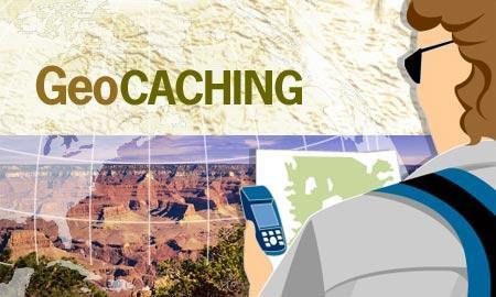
5 We will use the Global Positioning System to understand that latitude and longitude are actual addresses to a place, which is the absolute location. We will also introduce a fun family hobby geocaching!


6 What is a cache? A cache is usually a waterproof container filled with a log book and sometimes prizes. Source: Geocaching is high-tech hide and seek using a GPS receiver to find hidden caches. It has been called the new sport for the 21 st century!
 in to the GPS.")
7 Select a cache from a geocaching website that is near where you want to search. Gather your equipment. Enter the latitude and longitude coordinates (or waypoints) in to the GPS. Take an adult, drive as close to the area as possible, then hike to the site using your GPS receiver to lead the way.


8 Once you get to about 10 feet, turn on your detective skills and search for the cache. Think like a geocacher! Watch out for geomuggles! After finding the cache, sign the logbook, if you take an item, put something back. Most importantly, put the cache back in the exact spot you found it!

9 Have someone with you!!!!! Tell someone where you are going! Be aware of your surroundings. Take water. Mark your starting point with your GPS. Respect the environment and the site. Don t forget to post your find and comments about the cache on the internet, but remember avoid spoilers.

10 Source: Geocaching.com

11 Tell me and I'll forget; show me and I may remember; involve me and I'll understand. -Chinese Proverb Dropout Rate!

12 Facilitates inquiry-based learning Adaptable for any subject area Improves technological proficiency Fosters innovative instruction Increases student motivation

13 Source: NC DPI Geocaching
14 Dr. Alice Christie Dr. Christie s GPS and Geocaching Guide for Educators We ll look at these links: Steps in Creating a GPS/Geocaching Lesson Middle School: National Parks Lesson High School: Categorizing and Graphing Lesson
15 Can my library afford these? Grant ideas or borrowing from DPI! Source: Walmart December 28, 2010

16 Source: Google Maps Joyner Library

17 Press the flat button on the right side of the GPS. Hold until it powers on. Press the Page button to navigate to the Main Menu.


18 Satellite Page Map Page Navigation Page Trip Page Main Page


19 Nearest 1. Choose Waypoints 2. Choose Nearest 3. Choose from List Ours will say: RED YELLOW BLUE GREEN


20 Using the click stick select Select Goto at the bottom of the screen..


21 Check to see if you are 15 feet or.15 miles Walk 5 steps to orient the compass Move in the direction that the compass arrow is pointing. Think like a geocacher! Watch out for geomuggles


22 Marking a Geocache you hide! Stay with the group and within the boundaries set forth. Do not hide it in an area that has mud, standing water, briars, poison ivy, dangerous, etc. Finding a good hiding space. On main menu, click MARK over the space that your cache is hidden. Click inside the flag to name your cache using the abc keyboard. Click OK Then click OK again at the bottom of the screen to get back to main menu.
23
The GPS Classroom. Jared Covili
 The GPS Classroom Jared Covili 1/17/06 2 The GPS Classroom Jared Covili jcovili@media.utah.edu (801) 585-5667 The GPS Classroom is a 2-day course that provides participants with the basic knowledge of
HOW CAN A GPS HELP? WHY A GPS? HOW DOES A GPS WORK?
 HOW CAN A GPS HELP? WHY A GPS? HOW DOES A GPS WORK? WHO INVENTED GPS? About The GPS Satellites There are 24-32 different satellites in space 2005 They orbit the Earth every 12 hours in 6 different planes
Dr. Heather Petcovic TECHNOLOGY FOR TEACHING: HANDHELD GPS AND EARTHCACHING
 TECHNOLOGY FOR TEACHING: HANDHELD GPS AND EARTHCACHING Dr. Heather Petcovic Department of Geosciences and the Mallinson Institute for Science Education TECHNOLOGY FOR TEACHING: HANDHELD GPS AND EARTHCACHING
Blacksburg, VA May 21 st May 26 th, 2011 GPS Receivers and Geocaching Page 1. GPS Receivers & Geocaching Details. GPS Receivers etrex H
 GPS Receivers & Geocaching Details John McGee Jennifer McKee Prepared by: With support from: NSF DUE-0903270 in partnership with: Geospatial Technician Education Through Virginia s Community Colleges (GTEVCC)
GPS Activities 1. Trust em, but don t tempt em: 2. Mark & Find: 3. How many satellites?
 GPS Activities Here are GPS activities you can do in South Dakota State Parks, on the road, or at home. Global Positioning System (GPS) receivers excite young people and adults as well. Take this natural
What is it? History. Other systems. How does it work? Trilateration GEOG 201 4/28/2010. Instructor: Pesses 1. {06} The Global Positioning System
 What is it? {06} The Global Positioning System G.P.S. = Global Positioning System Different from G.I.S. (Geographic Information Systems) Map Interpretation & GPS Spring 2010 M. Pesses History Conceived
Smart GPS Sync. Manual. Smart GPS Sync. Manual
 allows you to transfer GPS data from single photos (shot with a smartphone for example) from a GPX file or specific latitude and longitude data to any number of photos without GPS tag. Load Photos To open
Understanding and using your GPS Receiver (Version date: 2 February 2007)
") Understanding and using your GPS Receiver (Version date: 2 February 2007) Authors: Helen Durham and Katherine Arrell School of Geography, University of Leeds, UK Contents 1. Aims...2 2. Learning Outcomes...2
Understanding and using your GPS Receiver (Version date: 2 February 2007) Authors: Helen Durham and Katherine Arrell School of Geography, University of Leeds, UK Contents 1. Aims...2 2. Learning Outcomes...2
Manual Web Portal pettracer GPS cat collar Version 1.0
 Page 1 / 10 Table of Content System Overview... 3 How the pettracer system works... 3 Live Tracking Mode (Real Time)... 3 Passive Tracking Mode... 3 Web portal access via Smartphone and Web browser...
GPS for Snowmobilers. By Wayne Fischer. November 14, 2006
 GPS for Snowmobilers By Wayne Fischer November 14, 2006 Wayne@TahoeSnowmobiling.org Copy of White Paper & Presentation Both this presentation and the white paper are available on the www.tahoesnowmobiling.org
Introduction to Geocaching in Alaska
 Introduction to Geocaching in Alaska compiled by NorthWes (aka Wes Skinner) 1. Why Geocache? 2. GeocacheAlaska! Inc. 3. Basic Gear 4. Ethics of the Game 5. Basics of the hunt 6. Let s go find a cache!
Here is a video that is very helpful
 This lesson from The Electric Quilt Company accompanies the Electric Quilt s article, Playing with Color and Fabric Choices in EQ7, on page 80 in the Summer 2016 issue of Modern Quilts Unlimited. Enjoy!
Where's the Treasure?
 Where's the Treasure? Introduction: In this project you will use the joystick and LED Matrix on the Sense HAT to play a memory game. The Sense HAT will show a gold coin and you have to remember where it
Lesson Plan 1 Introduction to Google Earth for Middle and High School. A Google Earth Introduction to Remote Sensing
 A Google Earth Introduction to Remote Sensing Image an image is a representation of reality. It can be a sketch, a painting, a photograph, or some other graphic representation such as satellite data. Satellites
J. La Favre Fusion 360 Lesson 5 April 24, 2017
 In this lesson, you will create a funnel like the one in the illustration to the left. The main purpose of this lesson is to introduce you to the use of the Revolve tool. The Revolve tool is similar to
Location Tracking. Current Technologies 1/19/2011. Not one, single technology Convergence of several technologies. Systems for
 Don Mason Associate Director Copyright 2011 National Center for Justice and the Rule of Law All Rights Reserved Location Tracking Not one, single technology Convergence of several technologies Systems
eipiorer, part detective. You'll search for treasure
 =. i-::= =i{t.o.aching is your chance to be part global eipiorer, part detective. You'll search for treasure chests, known as "geocaches," using a device called a GPS receiver to flnd each chest's secret
Introduction to Geocaching by. What is Geocaching? Stacy Byas (Saidbystacy) & GeocacheAlaska! members Kincaid Park. What is Geocaching?
 & GeocacheAlaska! members Kincaid Park. What is Geocaching?") Introduction to Geocaching by Stacy Byas (Saidbystacy) & GeocacheAlaska! members Kincaid Park 5 June 2010 Introduction to Geocaching 1 What is Geocaching? First the disclaimers: Geocaching.com is owned
Introduction to Geocaching by Stacy Byas (Saidbystacy) & GeocacheAlaska! members Kincaid Park 5 June 2010 Introduction to Geocaching 1 What is Geocaching? First the disclaimers: Geocaching.com is owned
UNITED NATIONS UNIVERSITY Institute for Environment & Human Security (UNU-EHS) Bonn, Germany
 Bonn, Germany") UNITED NATIONS UNIVERSITY Institute for Environment & Human Security (UNU-EHS) Bonn, Germany Introduction to GPS technology Prof. Dr. Jörg Szarzynski Education Programme Director Head of Section EduSphere
UNITED NATIONS UNIVERSITY Institute for Environment & Human Security (UNU-EHS) Bonn, Germany Introduction to GPS technology Prof. Dr. Jörg Szarzynski Education Programme Director Head of Section EduSphere
Mapping The Study Area
 While on the beach you will need to take some measurements to show where the study area is relative to the rest of the world and to show what is inside the study area. Once the measurements have been taken,
BGRI Stem Rust Survey Protocol. Overview of Field Survey Procedure
 Overview of Field Survey Procedure 1. Ensure survey team have all items on check-list before departure 2. Travel to 1 st survey location 3. At survey location switch on GPS 4. Wait until GPS receives satellite
Introduction to the Global Positioning System
 GPS for ICS - 2003 Introduction to the Global Positioning System Pre-Work Pre-Work Objectives Describe at least three sources of GPS signal error, and ways to mitigate or reduce those errors. Identify
Introduction to the Global Positioning System
 GPS for Fire Management - 2004 Introduction to the Global Positioning System Pre-Work Pre-Work Objectives Describe at least three sources of GPS signal error, and identify ways to mitigate or reduce those
Field Experience with GPS: Verifying GPS Coordinates Using USAPhotoMaps Software
 Field Experience with GPS: Verifying GPS Coordinates Using USAPhotoMaps Software Prepared by: Background: USAPhotoMaps requires that the user understand and know how to operate a GPS unit, and organize
Scratch for Beginners Workbook
 for Beginners Workbook In this workshop you will be using a software called, a drag-anddrop style software you can use to build your own games. You can learn fundamental programming principles without
Rino 750/755t. Owner s Manual
 Rino 750/755t Owner s Manual 2016 Garmin Ltd. or its subsidiaries All rights reserved. Under the copyright laws, this manual may not be copied, in whole or in part, without the written consent of Garmin.
5 STEP INVITATION PROCESS
 5 STEP INVITATION PROCESS The Beachbody Ultimate Reset is a breakthrough program that can help you release years of accumulated toxins, which can lead to premature aging and other health conditions such
Introduction to Computer Science with MakeCode for Minecraft
 Introduction to Computer Science with MakeCode for Minecraft Lesson 3: Coordinates This lesson will cover how to move around in a Minecraft world with respect to the three-coordinate grid represented by
Importing encrypted pattern using CS7
 Importing encrypted pattern using CS7 There are 2 databases associated with CS7. One is referred to as the local database and the other is referred to as the cloud database. The key to opening the cloud
Geocache Placement FUNdamentals presented by Lisa Echard (FlightRiskAK) Tonight s Topics: Cache Site Selection. Geocache Alaska! Inc.
 Tonight s Topics: Cache Site Selection. Geocache Alaska! Inc.") Geocache Placement presented by Lisa Echard (FlightRiskAK) Prepared by SSO JOAT Anchorage BP Energy Center & Broadcast over the Internet via WebEx 19 April 2012 Tonight s Topics: Permits and Permissions
Geocache Placement presented by Lisa Echard (FlightRiskAK) Prepared by SSO JOAT Anchorage BP Energy Center & Broadcast over the Internet via WebEx 19 April 2012 Tonight s Topics: Permits and Permissions
Sections of the Award There are FOUR sections of the Award Scheme Volunteering Skill (hobby) Physical Recreation (Sport) Expedition
 Physical Recreation (Sport) Expedition") The Duke of Edinburgh s Award @KTS 2009 Sections of the Award There are FOUR sections of the Award Scheme Volunteering Skill (hobby) Physical Recreation (Sport) Expedition Volunteering - Introduction This
The Duke of Edinburgh s Award @KTS 2009 Sections of the Award There are FOUR sections of the Award Scheme Volunteering Skill (hobby) Physical Recreation (Sport) Expedition Volunteering - Introduction This
Davis Art Images: Create and Share Slideshows
 Davis Art Images: Create and Share Slideshows Davis Art Images, you can create and curate custom sets of images to use in your art room with Tags. Your Tagged Image Sets can then be viewed and presented
Tech Tips from Mr G Borrowing ebooks and Audiobooks Using OverDrive 3.2 on Apple ios Devices 2015
 Tech Tips from Mr G Borrowing ebooks and Audiobooks Using OverDrive 3.2 on Apple ios Devices 2015 The Liverpool Public Library, the larger Onondaga County system, and libraries all over the country, subscribe
How to Blog to the Vanguard Website
 How to Blog to the Vanguard Website Guidance and Rules for Blogging on the Vanguard Website Version 1.01 March 2018 Step 1. Get an account The bristol vanguard website, like much of the internet these
Route 66 GPS Turn By Turn - Quick Start Guide
 Route 66 GPS Turn By Turn - Quick Start Guide Getting Started First, turn the unit on by pressing the power button on the upper right corner of the device. The device will boot up and go to the Main Menu.
GPS Position Sensor PS-2175
 In s tr u c ti o n M a n u a l 012-09919A GPS Position Sensor PS-2175! Table of Contents Contents Introduction........................................................... 3 Theory of Operation....................................................
GotSoccer works well with and recommends using Internet Explorer, Safari and Google Chrome.
 Cal North CCSL Member Clubs Internet Browser Notice: GotSoccer works well with and recommends using Internet Explorer, Safari and Google Chrome. Some GotSoccer features will not work with Firefox Using
Geocaching: High-Tech Hide-and-Seek. Che-Ming Chen. Abstract
 105 39 92 11 Geographical Research No. 39, November. 2003 Geocaching Geocaching: High-Tech Hide-and-Seek Che-Ming Chen Abstract With a handheld GPS unit, more than 150,000 players seek over 70,000 caches
STRIKER Series. Owner s Manual
 STRIKER Series Owner s Manual Table of Contents Introduction...1 Device Keys... 1 Contacting Garmin Product Support... 1 Selecting the Transducer Type... 1 Zooming on the STRIKER 4... 1 Panning on the
Classic Camping Cookbook & Meal Planner App Review
 Classic Camping Cookbook & Meal Planner App Review Fall camping time is here. Time to cook out - Coleman has the Cookout Cookbook & Meal Planner app from the Apple store to help you prepare meals during
MEASURE Evaluation. Global Positioning System Toolkit
 Global Positioning System Toolkit Global Positioning System Toolkit This tool was made possible by support from the U.S. Agency for International Development (USAID) under terms of Cooperative Agreement
Tech Tips from Mr G Borrowing ebooks and Audiobooks Using OverDrive 3.2 on Android Devices, Including the Kindle Fire
 Tech Tips from Mr G Borrowing ebooks and Audiobooks Using OverDrive 3.2 on Android Devices, Including the Kindle Fire - 2015 The Liverpool Public Library, the larger Onondaga County system, and libraries
Comparing Across Categories Part of a Series of Tutorials on using Google Sheets to work with data for making charts in Venngage
 Comparing Across Categories Part of a Series of Tutorials on using Google Sheets to work with data for making charts in Venngage These materials are based upon work supported by the National Science Foundation
Introduction to NAVSTAR GPS
 Introduction to NAVSTAR GPS Charlie Leonard, 1999 (revised 2001, 2002) The History of GPS Feasibility studies begun in 1960 s. Pentagon appropriates funding in 1973. First satellite launched in 1978. System
Digital Surveillance Devices?
 Technology Framework Tracking Technologies Don Mason Associate Director Digital Surveillance Devices? Digital Surveillance Devices? Secure Continuous Remote Alcohol Monitor SCRAM Page 1 Location Tracking
Global Positioning System
 Global Positioning System Physics 1010 Term Paper Adrianne Bernardo 2012 Global Positioning System (GPS) Have you ever found yourself out in the middle of a marsh, phragmites 10 feet tall all around you
GLOBAL POSITIONING SYSTEMS
 GLOBAL POSITIONING SYSTEMS Maps & Geospatial Concepts Fall 2015 Before GPS Historical look at navigation Giant concrete arrows that point your way across America What are these giant arrows? Some kind
GPS-G5 User s Manual
 GPS-G5 User s Manual Contents Using the GPS... 1 Description...1 Electrical Connections...2 Mounting...3 GPS Configuration...3 GPS Operation...3 Logging Device Configuration...4 Data Analysis...5 Specifications...
BULLYDOWN PHASE ONE BULLETIN BOARD FOCUS GROUP: MODERATOR SCRIPT
 BULLYDOWN PHASE ONE BULLETIN BOARD FOCUS GROUP: MODERATOR SCRIPT [Note: This is a template. Questions will evolve based on the content of the discussions.] Objectives: 1. To illuminate the current exposure
Photoshop Exercise 2 Developing X
 Photoshop Exercise 2 Developing X X-ray Vision: In this exercise, you will learn to take original photographs and combine them, using special effects. The objective is to create a portrait of someone holding
Accessing e-books with your e-reader
 e-reader 1 Accessing e-books with your e-reader What you need to know about library e-books is that each one is protected by Digital Rights Management (DRM). This means that access to e-books is restricted
GIS and Remote Sensing BIO8014. Data acquisition
 GIS and Remote Sensing BIO8014 Data acquisition Introduction Data can be manually created Data can be obtained from a wide range of providers both free and at cost Acquisition is key and must be accounted
Tech Topic Sign Data Overlay for Google Earth
 Tech Topic Sign Data Overlay for Google Earth The Delaware T 2 Center s RoadVista 922 retroreflectometer stores a great deal of information for each inventoried sign. It saves the date and time the information
Digital surveillance devices?
 Technology Framework Tracking Technologies Don Mason Associate Director Copyright 2011 National Center for Justice and the Rule of Law All Rights Reserved Digital surveillance devices? Digital surveillance
MEDIA CONVERSION PROJECT: DIGITIZING HISTORIC PHOTOS
 MEDIA CONVERSION PROJECT: DIGITIZING HISTORIC PHOTOS What you need to know: Basic understanding of a computer What you need: Computer Epson Perfection V550 Scanner (available in the Southglenn and Smoky
What is a GPS How does GPS work? GPS Segments GPS P osition Position Position Accuracy Accuracy Accuracy GPS A pplications Applications Applications
 What is GPS? What is a GPS How does GPS work? GPS Segments GPS Position Accuracy GPS Applications What is GPS? The Global Positioning System (GPS) is a precise worldwide radio-navigation system, and consists
USER MANUAL VOLANS PUBLIC DISPLAY FOR JOHN WAYNE AIRPORT
 VOLANS PUBLIC DISPLAY FOR JOHN WAYNE AIRPORT BridgeNet International Contents 1 Welcome... 2 1.1 Accessibility... 2 1.2 Navigation... 2 1.3 Map Display... 4 2 Menu Bar... 5 2.1 Show Flights... 5 2.2 Adjust
Google Photos Online Basics
 Google Photos Online Basics Click here to return to the Computer Club s website Adding new photos to your Google Photos - Three Ways Google Photos Uploader From Google Photos website click upload for individual
Lesson 4: Develop and Launch an Engaging Website
 Chapter 1, Video 1: "Welcome to Lesson 4" Welcome to Lesson number 4. This is a lesson in which the old proverbial the rubber meets the road. To this point, you've created a strategy. You've got your business
My Blogs: To Add New Blog Post: o Click on the My Learn360 link. You will then see eight different tabs (below).
.") My Blogs: Every user on Learn360 is given one blog. A blog can be shared throughout Learn360 and there is no limit to the number of blog posts. Blogs are a great way for teachers to interact with students
My Blogs: Every user on Learn360 is given one blog. A blog can be shared throughout Learn360 and there is no limit to the number of blog posts. Blogs are a great way for teachers to interact with students
USER MANUAL VOLANS PUBLIC DISPLAY FOR JOHN WAYNE AIRPORT
 VOLANS PUBLIC DISPLAY FOR JOHN WAYNE AIRPORT BridgeNet International Contents 1 Welcome... 2 1.1 Accessibility... 2 1.2 Navigation... 2 1.3 Interface Discovery... 4 2 Menu Bar... 5 2.1 Show Flights...
Scripted Introduction
 things you should know first: Technology Desktops & Laptops Access by internet browser at zoou.centervention.com nothing to download. Tablets Download free app Puffin Acdemy. More info in the Resources
Tech Tips from Mr G Introducing Libby - The New Face of OverDrive
 Tech Tips from Mr G Introducing Libby - The New Face of OverDrive OverDrive has introduced a new app called Libby, that s designed to make your experience borrowing ebooks and audiobooks through them much
Good morning, I m Travis Griggs, and I run a company called StrikeLines Charts. Briefly, what we do at StrikeLines is use side scan sonar data, like
 Good morning, I m Travis Griggs, and I run a company called StrikeLines Charts. Briefly, what we do at StrikeLines is use side scan sonar data, like you see in the background here, 1 To make high-end digital
Name: The Best Day I Ever Spent With My Family
 Name: The Best Day I Ever Spent With My Family What is the best day you have ever spent with your family? Think about the best day that you ever spent with your family. Think about reasons that made it
The horse image used for this tutorial comes from Capgros at the Stock Exchange. The rest are mine.
 First off, sorry to those of you that are on the mailing list or RSS that get this twice. I m finally moved over to a dedicated server, and in doing so, this post was lost. So, I m republishing it. This
Unit 3.11 Introduction to Absolute & Polar Coordinates in AutoCAD Ardrey Kell High School Charlotte, NC Date: 11/18/13 (Revision II)
") Unit 3.11 Introduction to Absolute & Polar Coordinates in AutoCAD X,Y,Z @3
Unit 3.11 Introduction to Absolute & Polar Coordinates in AutoCAD X,Y,Z @3
COMMERCIAL LEVEL SIMULATIONS
 PANEL AND VIRTUAL COCKPIT MANUAL COMMERCIAL LEVEL SIMULATIONS Commercial Level Simulations www.commerciallevel.com PANEL AND VIRTUAL COCKPIT MANUAL 1 Disclaimer This manual is not provided from, or endorsed
Tinker Tuesday Project - Stainless Steel Tumblers
 Tinker Tuesday Project - Stainless Steel Tumblers 1. Open CorelDRAW and create a new document. Near the top left corner of the screen, click File, and then click Import on the resulting menu. Select an
Speaking Notes for Grades 4 to 6 Presentation
 Speaking Notes for Grades 4 to 6 Presentation Understanding your online footprint: How to protect your personal information on the Internet SLIDE (1) Title Slide SLIDE (2) Key Points The Internet and you
GRAPHOGAME User Guide:
 GRAPHOGAME User Guide: 1. User registration 2. Downloading the game using Internet Explorer browser or similar 3. Adding players and access rights to the games 3.1. adding a new player using the Graphogame
GP online services Patient Guide
 Patient Guide easy read 1 Reading this booklet This booklet uses easy words and pictures to help you understand more about GP online services. You might want to read through it with someone else to support
Tinker Tuesday Project - Drinking Glasses
 Tinker Tuesday Project - Drinking Glasses 1. Open CorelDRAW and create a new document. Near the top left corner of the screen, click File, and then click Import on the resulting menu. Select an image from
a Touchscreen b On/Off button c Memory card (SD card) slot d USB connector e Charging connector f Reset button B A memory card (SD card)
 slot d USB connector e Charging connector f Reset button B A memory card (SD card)") TomTom RIDER 1. What s in the box What s in the box A Your TomTom RIDER 1 2 3 4 5 6 a Touchscreen b On/Off button c Memory card (SD card) slot d USB connector e Charging connector f Reset button B A memory
TomTom RIDER 1. What s in the box What s in the box A Your TomTom RIDER 1 2 3 4 5 6 a Touchscreen b On/Off button c Memory card (SD card) slot d USB connector e Charging connector f Reset button B A memory
Using OCAD for training
 Using OCAD for training OCAD: a computer aided drawing package that is usually used for producing orienteering maps. Version 8 can also be used for course planning (up to 30 controls with the free demo
Tinker Tuesday Project - Fabric Engraving
 Tinker Tuesday Project - Fabric Engraving 1. Open CorelDRAW and create a new document. On the toolbar on the left side of the screen, select the Basic Shapes tool icon. This will allow you to create simple
SAVING, LOADING AND REUSING LAYER STYLES
 SAVING, LOADING AND REUSING LAYER STYLES In this Photoshop tutorial, we re going to learn how to save, load and reuse layer styles! Layer styles are a great way to create fun and interesting photo effects
Getting started with GP online services Easy Read
 Getting started with GP online services Easy Read For more information visit www.nhs.uk/patientonline and register for your online services at your GP. 2 What you need to know Wouldn t it be great if you
Introduction Getting Started
 Introduction Getting Started 1. If you haven t done it already, download Google Earth TM 5.0 from earth.google.com and install it on your computer. 2. If you haven t done it already, download the Essentials_3E_Geotours.kmz
Social Media and Networking
 Social Media and Networking Student Workbook Student Workbook Page 1 Introduction: This workbook is a companion guide to be used with the online Social Media and Networking course. To develop expertise
In this tutorial you will open a Dxf file and create the toolpath to remove the material contained in a closed profile.
 Tutorial 3 - Open Dxf file and create the Pocket toolpath. In this tutorial you will open a Dxf file and create the toolpath to remove the material contained in a closed profile. Caution: CNC machines
Land Cover Change Analysis An Introduction to Land Cover Change Analysis using the Multispectral Image Data Analysis System (MultiSpec )
") Land Cover Change Analysis An Introduction to Land Cover Change Analysis using the Multispectral Image Data Analysis System (MultiSpec ) Level: Grades 9 to 12 Macintosh version Earth Observation Day Tutorial
Land Cover Change Analysis An Introduction to Land Cover Change Analysis using the Multispectral Image Data Analysis System (MultiSpec ) Level: Grades 9 to 12 Macintosh version Earth Observation Day Tutorial
Cockpit GPS Quick Start Guide
 Cockpit GPS Quick Start Guide Introduction My online book, Cockpit GPS, has grown to over 250 pages. I have that much information because at one time or another I thought that each piece would be useful
Resection. We can measure direction in the real world! Lecture 10: Position Determination. Resection Example: Isola, Slovenia. Professor Keith Clarke
 Geography 12: Maps and Spatial Reasoning Lecture 10: Position Determination We can measure direction in the real world! Professor Keith Clarke Resection Resection Example: Isola, Slovenia Back azimuth
Following this guide will make step 1 a snap. FOLLOW IT CLOSELY And This Is Elementary SIMPLE!
 Following this guide will make step 1 a snap. FOLLOW IT CLOSELY And This Is Elementary SIMPLE!. (You can print this by right clicking you mouse and clicking print, going up to File>Print, or using the
The preferred browser for using PaySchools is Google Chrome PaySchools is not compatible with Internet Explorer 11 and above!
 The PaySchools Central link for Chippewa Valley Schools can be found on the CVS website in the For Parents section. It is located on the right hand side within the gray banner. Click the link to go to
GPS Tutorial Trimble Home > GPS Tutorial > How GPS works? > Triangulating
 http://www.trimble.com/gps/howgps-triangulating.shtml Page 1 of 3 Trimble Worldwide Popula PRODUCTS & SOLUTIONS SUPPORT & TRAINING ABOUT TRIMBLE INVESTORS GPS Tutorial Trimble Home > GPS Tutorial > How
Kenya Bird Map. 12 simple steps to submit your records
 Kenya Bird Map http://kenyabirdmap.adu.org.za/ 12 simple steps to submit your records Step 1: Go to kenyabirdmap.adu.org.za How to submit a Card/ field sheet Step 2: Log in using the email you registered
Creating a Frame by Frame Animation for PhotoStory
 Creating a Frame by Frame Animation for PhotoStory There are an unlimited number of animation styles that you can create using the PhotoShop Elements software. Depending on the type of animation you want,
BeFitter Apps Manual
 BeFitter Apps Manual Key features The apps BF Hiker, BF Cycle, BF XC Ski and BF Runner have 13 pages. You can toggle through these pages with the previous page and next page function. See the chapter User
TABLE OF CONTENTS. Logging into the Website Homepage and Tab Navigation Setting up Users on the Website Help and Support...
 TABLE OF CONTENTS Logging into the Website...02 Homepage and Tab Navigation...03 Setting up Users on the Website...08 Help and Support...10 Uploding and Managing Photos...12 Using the Yearbook Ladder...16
In this tutorial you will open a Dxf file and create the toolpath that cut the external of the part.
 Tutorial 2 - Open Dxf file and create the outside Contour toolpath. In this tutorial you will open a Dxf file and create the toolpath that cut the external of the part. Caution: CNC machines are potentially
Getting Started. with Easy Blue Print
 Getting Started with Easy Blue Print User Interface Overview Easy Blue Print is a simple drawing program that will allow you to create professional-looking 2D floor plan drawings. This guide covers the
INTERNET SAFETY. OBJECTIVES: 1. Internet safety what is true and what is false? 2. & Instant Messaging safety 3. Strangers on the Internet
 LESSON 17 MIDDLE SCHOOL LESSON INTERNET SAFETY OBJECTIVES: 1. Internet safety what is true and what is false? 2. Email & Instant Messaging safety 3. Strangers on the Internet INDIANA STANDARDS (Grades
Cutwork With Generations Automatic Digitizing Software By Bernadette Griffith, Director of Educational Services, Notcina Corp
 In this lesson we are going to create a cutwork pattern using our scanner, an old pattern, a black felt tip marker (if necessary) and the editing tools in Generations. You will need to understand the basics
Cato s Hike Quick Start
 Cato s Hike Quick Start Version 1.1 Introduction Cato s Hike is a fun game to teach children and young adults the basics of programming and logic in an engaging game. You don t need any experience to play
ZONESCAN net Version 1.4.0
 ZONESCAN net.0 REV 1. JW ZONESCAN net 2 / 56 Table of Contents 1 Introduction... 5 1.1 Purpose and field of use of the software... 5 1.2 Software functionality... 5 1.3 Function description... 6 1.3.1
Revision Date: 6/6/2013. Quick Start Guide
 Revision Date: 6/6/2013 Quick Start Guide Important Notice Copyright 2013Frontline Test Equipment. All rights reserved. i Important Notice Table of Contents Purpose 1 Minimum Hardware Requirements 1 Internet
Next up, let s look at adding an item to your portfolio. You can add a variety of documents, audio and video directly to your portfolio or make a
 As part of Jefferson you now have access to a career building tool called Portfolium. This is a free electronic portfolio product that you may use with some of your courses or just when you re ready to
Creating Journey In AgentCubes
 DRAFT 3-D Journey Creating Journey In AgentCubes Student Version No AgentCubes Experience You are a traveler on a journey to find a treasure. You travel on the ground amid walls, chased by one or more