Scalable geospatial 3D client applications in X3D - Interactive, online and in real-time
|
|
|
- Roderick Lewis
- 6 years ago
- Views:
Transcription
1 Scalable geospatial 3D client applications in X3D - Interactive, online and in real-time Dipl.Inform.Univ Peter Schickel CEO Bitmanagement Software Vice President Web3D Consortium, Mountain View, USA OGC/Web3D liaison manager Presentation

2 X3D Geospatial Software Technology: Mapping geospatial 2D and 3D data at the correct location on a 3D globe automatically. Perception: Seamless zooming from map overview to ground level and Building interior with The same online software.

3 Bitmanagement Customers Industry adoption 375+ direct customers Users of applications in the millions Involved in future-oriented R&D


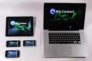


4 Create once run anywhere Hardware Independent Windows iphone IPad, Ipod Mac Stereoscopic devices Linux Cave Systems Android web browsers

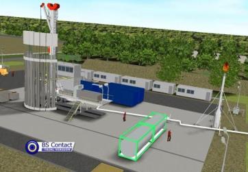
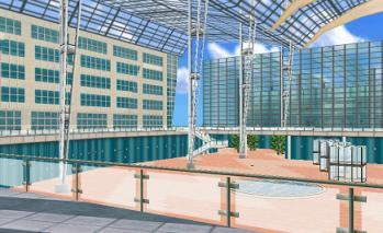
5 BS Contact GEO - BIM Online Viewing


6 Speed comparison Reference implementation vs Industry product X3DOM Java Script WebGL Frames per second: 36 BS Contact C++ Frames per second: 3365 X3DOM 25 pans Frames per second: 1 BS Contact 25 pans FPS: 1902 BS Contact 215 pans FPS: 637

7 BS Contact Mobile Android and Apple ios viewing


8 BS Content Studio Tool Production tool for easy animation of 3D from CAD and GIS With BS Contact Studio working time to create 3D environments is reduced by 80 % and less skills in 3D graphics are required. Author once - deploy anywhere Windows, Mac, Linux, ios, Android, IE, FF, Chrome, Safari, HTML5 / WebGL.


9 BS Contact 3D Engine Best in class online X3D viewer Huge Models Automated Geometry instancing Reduce 1.5 GB original size to 15 MB - Lossless interactive - collaborative Geometry Culling Real-time walk-through of full model Full detail and Meta-data preserved Bounding Box Representation Interactive Full Model View Full Details preserved 1.5 GB original Output for the Interactive 3D Web


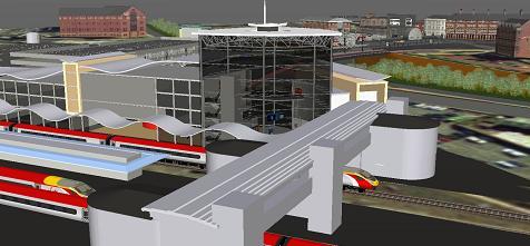
10 Daimler Automotive Internet Vehicle Navigation 2D/3D map-view, 3D globe view, 3D birdsview, 3D streetlevel view, 3D interior view, LOD 1-4 Visualization of 3D routing Mixing of video, audio, flash and html embedded in 3D scenes Interactive zooming, panning, flyover, 6 degrees of freedom navigation of users Points of interest, landmarks, tourist information Robust and adaptive Internet retrieval, content streaming, local cashing Night vision and weather


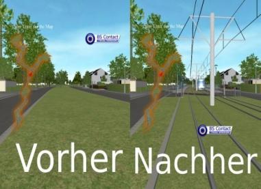
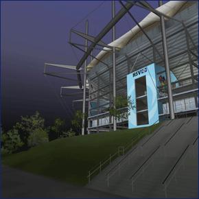
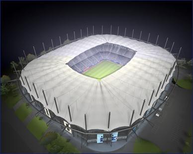
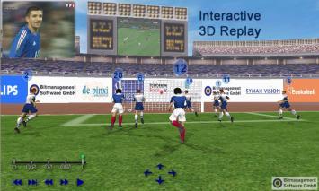
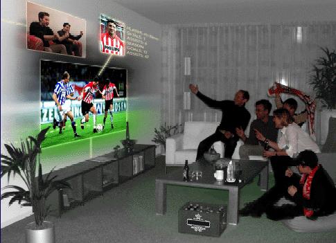
11 Siemens add on to WinCC 3D power facilities

12 Webinterface to ACIS Kernel Technology: The ACIS Kernel sends X3D models to the BS Contact client for visualization. The scene graph can be manipulated remotely.


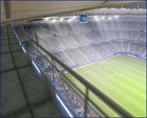
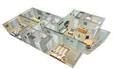
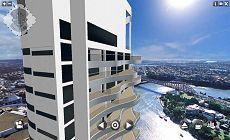
13 Municipality of Vienna Interactive Citymodel Technology: Complete cities can be visualized in realtime with BS Contact Geo on the Internet. Perception: Highly detailed appearance of the 3D city. High accuracy showing trees, building sites and fully textured houses.

14 Selected Geospatial Applications


15 Interactive Cities on the web Las Vegas Triangles Prague Triangles Stockholm Ca Triangles

16 3D cities realtime view Technology: Complete cities can be mapped in 3D automatically by flyover and visualized in realtime with BS Contact Geo on the Internet. Perception: Highly detailed appearance of the 3D city. High accuracy showing trees, building sites and fully textured houses.
17 Bertelsmann 3D Earth
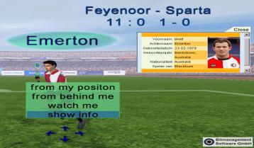
18 Interactive Soccer Game - HSV Soccer Arena

19 Visualization Outdoors and Indoors
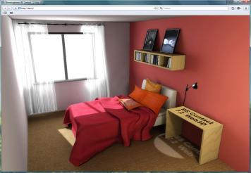
20 Interior visualization


21 BS Encrypt Content Encryption with strong security

22 Rapid Enviroment Building Technology: 3D environments can been constructed within hours semiautomatically from 2D Satellite Images. Usage: Missions can be rehearsed in multiuser sessions over the internet.
23 Comparison 3D PDF vs X3D 3D PDF X3D CAD Viewer Acrobat XI Pro BS Contact CAD Files BREP and Tesselation BREP, Spline and Tesselation ISO Standard Yes Yes Security Encryption Encryption 3D Measurements Yes Yes 3D Comments Yes Yes Compression Only zip grade. X3D binary better Web enabled No. All Data needs to be local. Yes. Data distributed on servers. Interactivity Only basic Fully interactive Platform support Windows, ios (?) Windows, Linux, ios, Android, Mac Taylor made APPs No Yes Multi-User No Yes with BS Collaborate Server Bitmanagement s X3D Technology can do similar things as 3DPDF and much more. Advantages: Fully Interactive Fully Web- Enabled Cross-platform: Windows, Mac ios, Android Cross-browser: IE, Chrome, FF, SF

 optimization Data reduction Tile")
24 BS Tiler Automated preparation of data Automatic tile building and optimization for fast rendering of data derived from point clouds, models and imagery Import of elevation grid data, grid textures and vectors Import of ESRI *.shp-files Triangulation and tile building Automatic level of detail (LOD) optimization Data reduction Tile edge optimization Output texture formats: JPEG, JPEG 2000, PNG, TGA and publish exemplar hybrid content


25 Reading native CityGML Streams - online and offline


26 Parcing of large data, on the 3D earth.

27 Fast Rendering Optimization Combining Textures - keeping Metainformation


28 Automated coordinate Transform and positioning on 3D Globe using EPSG Codes

29 CityGML databases and X3D visualization go hand in hand
30 BS Contact 3D Engine- Your window to your data Bitmanagement is uniquely suited with existing know-how and X3D software to elaborate a central and holistic view on your 3D data. This makes the life cycle of your data, with actual states, planning states and alternatives interactive, web-enabled, visible and usable.
31 Bitmanagement 3D Software Your 3D engine and tools Bitmanagement Software GmbH Oberlandstr Berg near Munich Germany Phone :
Extending X3D for Augmented Reality
 Extending X3D for Augmented Reality Seventh AR Standards Group Meeting Anita Havele Executive Director, Web3D Consortium www.web3d.org anita.havele@web3d.org Nov 8, 2012 Overview X3D AR WG Update ISO SC24/SC29
Web3D and X3D Overview
 Web3D and X3D Overview Web3D Consortium Anita Havele, Executive Director Anita.havele@web3d.org March 2015 Market Needs Highly integrated interactive 3D worlds Cities - Weather - building - Engineering
Web3D.org. March 2015 Anita Havele, Executive Director
 March 2015 Anita Havele, Executive Director Anita.havele@web3d.org Market Needs for 3D Highly integrated interactive 3D worlds Cities - Weather - building - Engineering - scientific Web as the delivery
Web3D Standards. X3D: Open royalty-free interoperable standard for enterprise 3D
 Web3D Standards X3D: Open royalty-free interoperable standard for enterprise 3D ISO/TC 184/SC 4 - WG 16 Meeting - Visualization of CAD data November 8, 2018 Chicago IL Anita Havele, Executive Director
ISO JTC 1 SC 24 WG9 G E R A R D J. K I M K O R E A U N I V E R S I T Y
 New Work Item Proposal: A Standard Reference Model for Generic MAR Systems ISO JTC 1 SC 24 WG9 G E R A R D J. K I M K O R E A U N I V E R S I T Y What is a Reference Model? A reference model (for a given
Open Standard based Visualization Infrastructure for 3D Geospatial Information
 X3D Earth Open Standard based Visualization Infrastructure for 3D Geospatial Information 13 January 2008 / Web3D Korea Forum 유병현 Byounghyun Yoo Web3D Consortium Fellow MOVES (Modeling, Virtual Environment
Arup is a multi-disciplinary engineering firm with global reach. Based on our experiences from real-life projects this workshop outlines how the new
 Alvise Simondetti Global leader of virtual design, Arup Kristian Sons Senior consultant, DFKI Saarbruecken Jozef Doboš Research associate, Arup Foresight and EngD candidate, University College London http://www.driversofchange.com/make/tools/future-tools/
Generating Virtual Environments by Linking Spatial Data Processing with a Gaming Engine
 Generating Virtual Environments by Linking Spatial Data Processing with a Gaming Engine Christian STOCK, Ian D. BISHOP, and Alice O CONNOR 1 Introduction As the general public gets increasingly involved
CMPT 165 INTRODUCTION TO THE INTERNET AND THE WORLD WIDE WEB
 CMPT 165 INTRODUCTION TO THE INTERNET AND THE WORLD WIDE WEB Unit 5 Graphics and Images Slides based on course material SFU Icons their respective owners 1 Learning Objectives In this unit you will learn
Virtual Reality Based Scalable Framework for Travel Planning and Training
 Virtual Reality Based Scalable Framework for Travel Planning and Training Loren Abdulezer, Jason DaSilva Evolving Technologies Corporation, AXS Lab, Inc. la@evolvingtech.com, jdasilvax@gmail.com Abstract
Mastering Autodesk Navisworks 2013
 Mastering Autodesk Navisworks 2013 Dodds, J ISBN-13: 9781118281710 Table of Contents Foreword xvii Introduction xix Part 1 Navisworks Basics 1 Chapter 1 Getting to Know Autodesk Navisworks 3 Interface
Programme TOC. CONNECT Platform CONNECTION Client MicroStation CONNECT Edition i-models what is comming
 Bentley CONNECT CONNECT Platform MicroStation CONNECT Edition 1 WWW.BENTLEY.COM 2016 Bentley Systems, Incorporated 2016 Bentley Systems, Incorporated Programme TOC CONNECT Platform CONNECTION Client MicroStation
Qt Developing ArcGIS Runtime Applications. Eric
 Qt Developing ArcGIS Runtime Applications Eric Bader @ECBader Agenda Getting Started Creating the Map Geocoding and Routing Geoprocessing Message Processing Working Offline The Next Release What s Coming
X3D Capabilities for DecWebVR
 X3D Capabilities for DecWebVR W3C TPAC Don Brutzman brutzman@nps.edu 6 November 2017 Web3D Consortium + World Wide Web Consortium Web3D Consortium is W3C Member as standards liaison partner since 1 April
Services Overview. Northeast Blueprint
 Services Overview 2D CAD Conversions Paper to CAD 2D CAD Conversions Construction Engineering / CAD Services Construction Markups Consultant Drawings Coordinated Drawings As -Builts Steel Structural Detailing
Specific structure or arrangement of data code stored as a computer file.
 FILE FORMAT Specific structure or arrangement of data code stored as a computer file. A file format tells the computer how to display, print, process, and save the data. It is dictated by the application
Video Requirements for Web-based Virtual Environments using Extensible 3D (X3D) Graphics
 Graphics") Video Requirements for Web-based Virtual Environments using Extensible 3D (X3D) Graphics Don Brutzman and Mathias Kolsch Web3D Consortium Naval Postgraduate School, Monterey California USA brutzman@nps.edu
Video Requirements for Web-based Virtual Environments using Extensible 3D (X3D) Graphics Don Brutzman and Mathias Kolsch Web3D Consortium Naval Postgraduate School, Monterey California USA brutzman@nps.edu
Microsoft ESP Developer profile white paper
 Microsoft ESP Developer profile white paper Reality XP Simulation www.reality-xp.com Background Microsoft ESP is a visual simulation platform that brings immersive games-based technology to training and
HMD based VR Service Framework. July Web3D Consortium Kwan-Hee Yoo Chungbuk National University
 HMD based VR Service Framework July 31 2017 Web3D Consortium Kwan-Hee Yoo Chungbuk National University khyoo@chungbuk.ac.kr What is Virtual Reality? Making an electronic world seem real and interactive
ArcGIS Runtime: Analysis. Lucas Danzinger Mark Baird Mike Branscomb
 ArcGIS Runtime: Analysis Lucas Danzinger Mark Baird Mike Branscomb ArcGIS Runtime session tracks at DevSummit 2018 ArcGIS Runtime SDKs share a common core, architecture and design Functional sessions promote
Topics VRML. The basic idea. What is VRML? History of VRML 97 What is in it X3D Ruth Aylett
 Topics VRML History of VRML 97 What is in it X3D Ruth Aylett What is VRML? The basic idea VR modelling language NOT a programming language! Virtual Reality Markup Language Open standard (1997) for Internet
Michigan State University Team MSUFCU Money Smash Chronicle Project Plan Spring 2016
 Michigan State University Team MSUFCU Money Smash Chronicle Project Plan Spring 2016 MSUFCU Staff: Whitney Anderson-Harrell Austin Drouare Emily Fesler Ben Maxim Ian Oberg Michigan State University Capstone
Virtual Reality as Innovative Approach to the Interior Designing
 SSP - JOURNAL OF CIVIL ENGINEERING Vol. 12, Issue 1, 2017 DOI: 10.1515/sspjce-2017-0011 Virtual Reality as Innovative Approach to the Interior Designing Pavol Kaleja, Mária Kozlovská Technical University
e!cmi - web based CATIA Metaphase Interface
 e!cmi - web based CATIA Metaphase Interface e!cmi Release 2.0 for CF2.0 User s Manual Copyright 1999, 2000, 2001, 2002, 2003 T-Systems International GmbH. All rights reserved. Printed in Germany. Contact
Online Browser Streaming and Mobile-App Instructions
 Online Browser Streaming and Mobile-App Instructions for ios, ipad, and iphone March 06 ...Access Comics Plus: Library Edition Through Your Online Browser...Install App from App Store 4...Check Out and
About us. What we do at Envrmnt
 W W W. E N V R M N T. C O M 1 About us What we do at Envrmnt 3 The Envrmnt team includes over 120 employees with expertise across AR/VR technology: Hardware & software development 2D/3D design Creative
Online Resources: KEY FEATURES
 Explore key features of online Earth science data tools that can be useful for K 12 student investigations. Sources are color coded for relative level/ease-of-use: BLUE (introductory); ORANGE (intermediate)
ArcGIS Runtime SDK for Java: Building Applications. Eric
 ArcGIS Runtime SDK for Java: Building Applications Eric Bader @ECBader Agenda ArcGIS Runtime and the SDK for Java How to build / Functionality - Maps, Layers and Visualization - Geometry Engine - Routing
Propietary Engine VS Commercial engine. by Zalo
 Propietary Engine VS Commercial engine by Zalo zalosan@gmail.com About me B.S. Computer Engineering 9 years of experience, 5 different companies 3 propietary engines, 2 commercial engines I have my own
Extensible 3D (X3D) Graphics and X3D Earth for Web-Interoperable Modeling, Simulation and Visualization
 Graphics and X3D Earth for Web-Interoperable Modeling, Simulation and Visualization") Extensible 3D (X3D) Graphics and X3D Earth for Web-Interoperable Modeling, Simulation and Visualization Demonstrating Potential for New Capabilities 21 July 2009 Don Brutzman Naval Postgraduate School
Extensible 3D (X3D) Graphics and X3D Earth for Web-Interoperable Modeling, Simulation and Visualization Demonstrating Potential for New Capabilities 21 July 2009 Don Brutzman Naval Postgraduate School
Factors to Consider When Choosing a File Type
 Factors to Consider When Choosing a File Type Compression Since image files can be quite large, many formats employ some form of compression, the process of making the file size smaller by altering or
Top 10 Things at Esri UC 2015 & ArcGIS Pro
 Top 10 Things at Esri UC 2015 & ArcGIS Pro Jim Tochterman, VP - Research & Development Who is BCS? Formed in 1998 in Aiken, SC Privately held and woman-owned Primary focus is GIS for Public Safety Esri
Web3D Consortium Medical WG Update. Nicholas F. Polys, PhD Virginia Tech Web3D Consortium
 Web3D Consortium Medical WG Update Nicholas F. Polys, PhD Virginia Tech Web3D Consortium Topics Introduction Rendering Volume Rendering Extensions Other Medical data 3D printing (NIH 3D Print Exchange)
ISO/IEC JTC 1 VR AR for Education
 ISO/IEC JTC 1 VR AR for January 21-24, 2019 SC24 WG9 & Web3D Meetings, Seoul, Korea Myeong Won Lee (U. of Suwon) Requirements Learning and teaching Basic components for a virtual learning system Basic
COMPUTER. 1. PURPOSE OF THE COURSE Refer to each sub-course.
 COMPUTER 1. PURPOSE OF THE COURSE Refer to each sub-course. 2. TRAINING PROGRAM (1)General Orientation and Japanese Language Program The General Orientation and Japanese Program are organized at the Chubu
Session 3 _ Part A Effective Coordination with Revit Models
 Session 3 _ Part A Effective Coordination with Revit Models Class Description Effective coordination relies upon a measured strategic approach to using clash detection software. This class will share best
Managing Imagery and Raster Data. Peter Becker
 Managing Imagery and Raster Data Peter Becker ArcGIS is a Comprehensive Imagery Platform Empowering you to make informed decisions System of Engagement System of Insight Extract Information from Imagery
Mixed and Augmented Reality Reference Model as of January 2014
 Mixed and Augmented Reality Reference Model as of January 2014 10 th AR Community Meeting March 26, 2014 Author, Co-Chair: Marius Preda, TELECOM SudParis, SC29 Presented by Don Brutzman, Web3D Consortium
CMI User Day - Product Strategy
 CMI User Day - Product Strategy CMI User Day 2003 New Orleans, USA CMI User Day 2003 New Orleans, USA Tino Schlitt T-Systems PLM Solutions CATIA Metaphase Interface - Overview Integration of CATIA V4 /
UNOSAT Satellite Imagery and GIS Solutions for DRR and Emergency Management
 UNOSAT Satellite Imagery and GIS Solutions for DRR and Emergency Management Francesco Pisano Director, Research, Technology Applications & Knowledge Systems January 2013 Introduction to UNOSAT 2 About
BlopHome Help. How to get started. 1 of 5. If you are not logged in blophome
 How to get started New If you are not logged in blophome Open 1 of 5 My site How to get started New If you are logged in blophome Open 1 of 5 My site How to get started 2 of 5 With one click move and modify
Accessible Power Tool Flexible Application Scalable Solution
 Accessible Power Tool Flexible Application Scalable Solution Franka Emika GmbH Our vision of a robot for everyone sensitive, interconnected, adaptive and cost-efficient. Even today, robotics remains a
SECTION GEOGRAPHIC INFORMATION SYSTEM (GIS)
") PART 1 - GENERAL 1.1 DESCRIPTION SECTION 11 83 01 A. Provide all labor, materials, manpower, tools and equipment required to furnish, install, activate and test a new Geographic Information System (GIS).
PART 1 - GENERAL 1.1 DESCRIPTION SECTION 11 83 01 A. Provide all labor, materials, manpower, tools and equipment required to furnish, install, activate and test a new Geographic Information System (GIS).
The browser must have the proper plugin installed
 "Advanced" Multimedia 1 Before HTML 5 Inclusion of MM elements in web pages Deprecated tag Audio Example: background music Video Example: embedded
Understanding Image Formats And When to Use Them
 Understanding Image Formats And When to Use Them Are you familiar with the extensions after your images? There are so many image formats that it s so easy to get confused! File extensions like.jpeg,.bmp,.gif,
DocuSign for ios: For Field Sales & Field Services
 DocuSign for ios: For Field Sales & Field Services How DocuSign for ios enables field sales and field services to transact business anytime, anywhere on ios devices Key Challenges FOR FIELD SALES AND SERVICES
SkylineGlobe 6 Technology Overview
 SkylineGlobe 6 Technology Overview w w w. S k y l i n e G l o b e. c o m Contents SKYLINEGLOBE PRODUCTS... 3 TERRAEXPLORER... 7 TERRAEXPLORER FAMILY... 7 TERRAEXPLORER PRODUCTS - MAIN FEATURES... 8 C2MP
Softing TDX ODX- and OTX-Based Diagnostic System Framework
 Softing TDX ODX- and OTX-Based Diagnostic System Framework DX (Open Diagnostic data exchange) and OTX (Open Test sequence exchange) standards are very well established description formats for diagnostics
POTENTIAL USE OF VIRTUAL ENVIRONMENTS IN DESIGN EDUCATION
 POTENTIAL USE OF VIRTUAL ENVIRONMENTS IN DESIGN EDUCATION Aysu SAGUN Middle East Technical University, NCC aysusagun@gmail.com ABSTRACT This paper explores the potential use of Virtual Environments (VE)
DICOM-compatible compression of WSI and diagnostic evaluation
 of WSI and diagnostic evaluation R. Zwönitzer, H. Hofmann, A. Roessner, T. Kalinski 2nd European Workshop in Tissue Imaging and Analysis June 25-26, 2010 - Heidelberg 1 GPWL / GP-PPS Introduction Overview
Building Java Apps with ArcGIS Runtime SDK
 Building Java Apps with ArcGIS Runtime SDK Vijay Gandhi, Elise Acheson, Eric Bader Demo Source code: https://github.com/esri/arcgis-runtime-samples-java/tree/master/devsummit-2014 Video Recording: http://video.esri.com
Global Positioning System (GPS)
") Global Positioning System (GPS) GPS enables users to easily record the location of natural and man-made features on the land. It allows users to identify where a photo or video is taken, revisit previously
Global Positioning System (GPS) GPS enables users to easily record the location of natural and man-made features on the land. It allows users to identify where a photo or video is taken, revisit previously
23270: AUGMENTED REALITY FOR NAVIGATION AND INFORMATIONAL ADAS. Sergii Bykov Technical Lead Machine Learning 12 Oct 2017
 23270: AUGMENTED REALITY FOR NAVIGATION AND INFORMATIONAL ADAS Sergii Bykov Technical Lead Machine Learning 12 Oct 2017 Product Vision Company Introduction Apostera GmbH with headquarter in Munich, was
Networks of any size and topology. System infrastructure monitoring and control. Bridging for different radio networks
 INTEGRATED SOLUTION FOR MOTOTRBO TM Networks of any size and topology System infrastructure monitoring and control Bridging for different radio networks Integrated Solution for MOTOTRBO TM Networks of
CADValidator: A Critical Aid for the Model-Based Enterprise
 CADValidator: A Critical Aid for the Model-Based Enterprise Abstract Learn the importance of validation for deployment of model-based engineering practices. In addition, understand what functionality is
Table of Contents HOL ADV
 Table of Contents Lab Overview - - Horizon 7.1: Graphics Acceleartion for 3D Workloads and vgpu... 2 Lab Guidance... 3 Module 1-3D Options in Horizon 7 (15 minutes - Basic)... 5 Introduction... 6 3D Desktop
GPS Apps for Smart Phone and PC YHA Bushwalking Club Night Presentation. Lutz Lademann May 2016
 GPS Apps for Smart Phone and PC YHA Bushwalking Club Night Presentation Lutz Lademann walks@lademann.de May 2016 Content How Does GPS Work What are GPX Files Where to Find GPX Files/Tracks/Walks How to
Downloading and formatting remote sensing imagery using GLOVIS
 Downloading and formatting remote sensing imagery using GLOVIS Students will become familiarized with the characteristics of LandSat, Aerial Photos, and ASTER medium resolution imagery through the USGS
VR/AR Concepts in Architecture And Available Tools
 VR/AR Concepts in Architecture And Available Tools Peter Kán Interactive Media Systems Group Institute of Software Technology and Interactive Systems TU Wien Outline 1. What can you do with virtual reality
Interactive Math Demos for Mobile Platforms
 2013 Hawaii University International Conferences Education & Technology Math & Engineering Technology June 10 th to June 12 th Ala Moana Hotel, Honolulu, Hawaii Interactive Math Demos for Mobile Platforms
About us. What we do at Envrmnt
 W W W. E N V R M N T. C O M 1 About us What we do at Envrmnt 3 The Envrmnt team includes over 120 employees with expertise across AR/VR technology: Hardware & software development 2D/3D design Creative
Transforming Industries with Enlighten
 Transforming Industries with Enlighten Alex Shang Senior Business Development Manager ARM Tech Forum 2016 Korea June 28, 2016 2 ARM: The Architecture for the Digital World ARM is about transforming markets
An IoT Based Real-Time Environmental Monitoring System Using Arduino and Cloud Service
 Engineering, Technology & Applied Science Research Vol. 8, No. 4, 2018, 3238-3242 3238 An IoT Based Real-Time Environmental Monitoring System Using Arduino and Cloud Service Saima Zafar Emerging Sciences,
Activities at SC 24 WG 9: An Overview
 Activities at SC 24 WG 9: An Overview G E R A R D J. K I M, C O N V E N E R I S O J T C 1 S C 2 4 W G 9 Mixed and Augmented Reality (MAR) ISO SC 24 and MAR ISO-IEC JTC 1 SC 24 Have developed standards
Drone Footage brief aerial video of the field. Field Tour. Videos details of the field in a series of short, liveaction
 Playing Field This page hosts links to a variety of ways FIRST Robotics Competition community can experience the DESTINATION: DEEP SPACE SM Presented By The Boeing Company playing field. FIRST is so grateful
Introduction to Virtual Environments - Spring Wernert/Arns. Lecture 5.2 Overview of VR Development Methods
 Introduction to Virtual Environments - Spring 2004 - Wernert/Arns Lecture 5.2 Overview of VR Development Methods Outline 1. Additional Rendering Issues 2. Overview of Software Tools for VR 3. Development
Accurate Real-time Indoor Navigation
 Accurate Real-time Indoor Navigation 1 Table of Content 1 Overview... 3 2 Market... 3 3 Indoor Localisation Technologies... 4 3.1 GPS/Assisted GPS... 4 3.2 Wi-Fi Trilateration Low Accuracy... 5 3.3 Hardware
1. Using Images on Web Pages 2. Image Formats 3. Bitmap Image Formats
 CMPT 165 INTRODUCTION TO THE INTERNET AND THE WORLD WIDE WEB By Hassan S. Shavarani UNIT5: GRAPHICS 1 TOPICS 1. Using Images on Web Pages 2. Image Formats 3. Bitmap Image Formats 2 THE TAG EXAMPLE
3D Virtual Training Systems Architecture
 3D Virtual Training Systems Architecture January 21-24, 2018 ISO/IEC JTC 1/SC 24/WG 9 & Web3D Meetings Seoul, Korea Myeong Won Lee (U. of Suwon) Virtual Training Systems Definition Training systems using
ITP 140 Mobile App Technologies. Images
 ITP 140 Mobile App Technologies Images Images All digital images are rectangles! Each image has a width and height 2 Terms Pixel A picture element Screen size In inches Resolution A width and height DPI
Manual For Use Google Earth Flight Simulator Ipad
 Manual For Use Google Earth Flight Simulator Ipad Have you ever wondered how to use the basic Google Earth features? Select this option through Google Earth's Tool's (Enter Flight Simulator link) or by
21 st Century Skills. Describe how satellite data is transmitted from space to Earth,
 Level of Difficulty: 4 Grade Range: 9-12 Activity Time: 45-60 min Business Category: IT Topic: Information and Communication OVERVIEW Information and Communication In this lesson, students will explore
An Approach to Integrating Modeling & Simulation Interoperability
 An Approach to Integrating Modeling & Simulation Interoperability Brian Spaulding Jorge Morales MÄK Technologies 68 Moulton Street Cambridge, MA 02138 bspaulding@mak.com, jmorales@mak.com ABSTRACT: Distributed
A study on facility management application scenario of BIMGIS modeling data
 International Journal of Engineering Science Invention ISSN (Online): 2319 6734, ISSN (Print): 2319 6726 Volume 6 Issue 11 November 2017 PP. 40-45 A study on facility management application scenario of
1. Any wide view of a physical space. a. Panorama c. Landscape e. Panning b. Grayscale d. Aperture
 Match the words below with the correct definition. 1. Any wide view of a physical space. a. Panorama c. Landscape e. Panning b. Grayscale d. Aperture 2. Light sensitivity of your camera s sensor. a. Flash
CS 262 Lecture 01: Digital Images and Video. John Magee Some material copyright Jones and Bartlett
 CS 262 Lecture 01: Digital Images and Video John Magee Some material copyright Jones and Bartlett 1 Overview/Questions What is digital information? What is color? How do pictures get encoded into binary
SWOP Soft Proofing Application Data Sheet for DALiM DiALOGUE
 SWOP Soft Proofing Application Data Sheet for DALiM DiALOGUE I. MANUFACTURER Dalim Software GmbH Strassburger Strasse, 6 Kehl am Rhein, D-77694 Germany http://www.dalim.com II. PRODUCT DALiM DiALOGUE,
Lesson Plan 1 Introduction to Google Earth for Middle and High School. A Google Earth Introduction to Remote Sensing
 A Google Earth Introduction to Remote Sensing Image an image is a representation of reality. It can be a sketch, a painting, a photograph, or some other graphic representation such as satellite data. Satellites
Center for Hybrid Multicore Productivity Research (CHMPR)
") A CISE-funded Center University of Maryland, Baltimore County, Milton Halem, Director, 410.455.3140, halem@umbc.edu University of California San Diego, Sheldon Brown, Site Director, 858.534.2423, sgbrown@ucsd.edu
A CISE-funded Center University of Maryland, Baltimore County, Milton Halem, Director, 410.455.3140, halem@umbc.edu University of California San Diego, Sheldon Brown, Site Director, 858.534.2423, sgbrown@ucsd.edu
TELLING STORIES OF VALUE WITH IOT DATA
 TELLING STORIES OF VALUE WITH IOT DATA VISUALIZATION BAREND BOTHA VIDEO TRANSCRIPT Tell me a little bit about yourself and your background in IoT. I came from a web development and design background and
Department of Computer Science and Engineering The Chinese University of Hong Kong. Year Final Year Project
 Digital Interactive Game Interface Table Apps for ipad Supervised by: Professor Michael R. Lyu Student: Ng Ka Hung (1009615714) Chan Hing Faat (1009618344) Year 2011 2012 Final Year Project Department
Upgrading Common Workflows from 10.2.x to 100.x with ArcGIS Runtime SDK for.net. Melanie Whalen & Lauren Boyd
 Upgrading Common Workflows from 10.2.x to 100.x with ArcGIS Runtime SDK for.net Melanie Whalen & Lauren Boyd Agenda Architectural Overview Maps Editing Analysis Resources Q&A Architectural Overview Architecture:
AR Glossary. Terms. AR Glossary 1
 AR Glossary Every domain has specialized terms to express domain- specific meaning and concepts. Many misunderstandings and errors can be attributed to improper use or poorly defined terminology. The Augmented
Skybox as Info Billboard
 Skybox as Info Billboard Jana Dadova Faculty of Mathematics, Physics and Informatics Comenius University Bratislava Abstract In this paper we propose a new way of information mapping to the virtual skybox.
High Performance Visualization : Scaling Rendering and Perception
 High Performance Visualization : Scaling Rendering and Perception Dr. Nicholas Polys, Director of Visual Computing, VT Information Technology Affiliate Professor, Computer Science Topic Overview Trends
GeoShield Web: Journey of a Silverlight Mashup
 GeoShield Web: Journey of a Silverlight Mashup Craig E. Oaks ESRI Federal User Conference February 2010 GeoShield Web Web-enabled geospatial mashup application focused on CBRN and Force Protection workflows.
Bitmap Vs Vector Graphics Web-safe Colours Image compression Web graphics formats Anti-aliasing Dithering & Banding Image issues for the Web
 Bitmap Vs Vector Graphics Web-safe Colours Image compression Web graphics formats Anti-aliasing Dithering & Banding Image issues for the Web Bitmap Vector (*Refer to Textbook Page 175 file formats) Bitmap
SECTION PHOTOGRAPHIC DOCUMENTATION
 SECTION 01 32 33 PHOTOGRAPHIC DOCUMENTATION PART 1 - GENERAL 1.1 RELATED DOCUMENTS A. Drawings and general provisions of the Contract, including General and Supplementary Conditions and other Division
18 th January 2018 Hyderabad. Shishir Verma Sr. Vice President
 18 th January 2018 Hyderabad Shishir Verma Sr. Vice President MapmyIndia At a Glance FOUNDED EMPLOYEES CONSUMER BASE ENTERPRISE CLIENTS CERTIFICATION CMMI ML 3 1995 750+ 5,000,000+ 5000+ ISO 9001:2008
Digital Microscopy: New Paradigm's for Teaching Microscopic Anatomy and Pathology
 Digital Microscopy: New Paradigm's for Teaching Microscopic Anatomy and Pathology Michael Feldman, MD, PhD Assistant Dean IT Assistant Professor Pathology University of Pennsylvania Health System Feldmanm@mail.med.upenn.edu
DALiM DiALOGUE - Apple 23 Cinema HD Display - GRACoL Coated #1
 Certified 04/08/08 Off-Press Proof Application Data Sheet DALiM DiALOGUE - Apple 23 Cinema HD Display - GRACoL Coated #1 The IDEAlliance Print Properties Working Group has established a certification process
How to Avoid Landmines: Managing your Motion Graphics Projects
 How to Avoid Landmines: Managing your Motion Graphics Projects -Richard Harrington, PMP www.rhedpixel.com 703.560.0220 Import Tips Double-Click in Project Window Shift-Click Multiple Items Organize in
Digital Imaging & Photoshop
 Digital Imaging & Photoshop Photoshop Created by Thomas Knoll in 1987, originally called Display Acquired by Adobe in 1988 Released as Photoshop 1.0 for Macintosh in 1990 Released the Creative Suite in
CONSTRUCTION MACHINES IN THE DIGITAL AGE CONSTRUCTION EQUIPMENT MAKERS NEED TO FIND THEIR PLACE IN SMART BUILDING SITES. Romed Kelp and David Kaufmann
 CONSTRUCTION MACHINES IN THE DIGITAL AGE CONSTRUCTION EQUIPMENT MAKERS NEED TO FIND THEIR PLACE IN SMART BUILDING SITES Romed Kelp and David Kaufmann At first glance, giant earth-moving excavators and
Chapter 3 Graphics and Image Data Representations
 Chapter 3 Graphics and Image Data Representations 3.1 Graphics/Image Data Types 3.2 Popular File Formats 3.3 Further Exploration 1 Li & Drew c Prentice Hall 2003 3.1 Graphics/Image Data Types The number
Seamless Navigation Demonstration Using Japanese Quasi-Zenith Satellite System (QZSS) and IMES
 and IMES") Seamless Navigation Demonstration Using Japanese Quasi-Zenith Satellite System (QZSS) and IMES ICG WG-B Application SG Meeting Munich, Germany March 12, 2012 Satellite Positioning Research and Application
Seamless Navigation Demonstration Using Japanese Quasi-Zenith Satellite System (QZSS) and IMES ICG WG-B Application SG Meeting Munich, Germany March 12, 2012 Satellite Positioning Research and Application
MOBILE VIRTUAL 3D MODEL OF A MEDIEVAL TOWN
 International Journal on Information Technologies & Security, 4, 2013 13 MOBILE VIRTUAL 3D MODEL OF A MEDIEVAL TOWN Stanislav Dimchev Kostadinov, Tzvetomir Ivanov Vassilev Department of Informatics and
A Distributed Virtual Reality Prototype for Real Time GPS Data
 A Distributed Virtual Reality Prototype for Real Time GPS Data Roy Ladner 1, Larry Klos 2, Mahdi Abdelguerfi 2, Golden G. Richard, III 2, Beige Liu 2, Kevin Shaw 1 1 Naval Research Laboratory, Stennis
Augmented Reality From Science to Mass-Market Stefan Misslinger, metaio, Inc.
 Augmented Reality From Science to Mass-Market Stefan Misslinger, metaio, Inc. Overview metaio company profile Augmented Reality Industrial AR solutions Marketing AR solutions Mobile AR Contact information
Thursday June 18, 2015 (Web3D Consortium Open Meeting)
") Thursday June 18, 2015 (Web3D Consortium Open Meeting) Hall MINOS II Time Registration 09:00-09:30 Efficient binary encoding: SRC geometric compression + EXI information compression 09:30-10:30 (Limper,
Thursday June 18, 2015 (Web3D Consortium Open Meeting) Hall MINOS II Time Registration 09:00-09:30 Efficient binary encoding: SRC geometric compression + EXI information compression 09:30-10:30 (Limper,