GeoShield Web: Journey of a Silverlight Mashup
|
|
|
- Lee Poole
- 5 years ago
- Views:
Transcription


1 GeoShield Web: Journey of a Silverlight Mashup Craig E. Oaks ESRI Federal User Conference February 2010
2 GeoShield Web Web-enabled geospatial mashup application focused on CBRN and Force Protection workflows. Rich Internet Application (RIA) CBRN Analysis (Chemical, Biological, Radiological & Nuclear) Analyzing, Defending Responding Performance Requirements Easy to Use Quick to Train Ready to Deploy


3 Project Sponsors Maneuver Support Center, Ft. Leonard Wood, MO ARDEC, Picatinny Arsenal, NJ ilab, Ft. Huachuca, AZ
4 Joint CBRN Working Group Subject Matter Experts (SMEs), Users & Customers National Guard CIP-MAA Teams Critical Infrastructure Protection Mission Assurance Assessment National Guard Civil Support Teams (CSTs) USAF Force Security Unit (Lackland AFB) STRATCOM US Army ECBC (Edgewood Chemical Biological Command) NGB (National Guard Bureau) US Army ARDEC (Armament Research, Development & Engineering Center) US Army MSCoE (Maneuver Support Center of Excellence) US Army ilab (Intelligence Lab) US Army ERDC (Engineer Research & Development Center)
 Cross-platform")
 on")

5 Key Technologies Microsoft Silverlight 3.0 Web browser plug-in (similar to Flash) Cross-platform Windows, Linux, Mac Cross-browser Internet Explorer, Firefox, Chrome, Safari Authority To Operate (ATO) on multiple DOD networks ESRI ArcGIS API for Silverlight Features Mapping Geocoding Geoprocessing Well documented & easy to use Zero deployment footprint


6 Mashup Components ArcGIS Online Maps & Streets Bing Maps IWMDT Weather GeoRSS Feeds USGS Seamless Imagery ArcGIS Server Services & Tasks 360 Video Amazon Web Services

7 WMS Layers
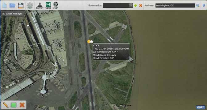
8 JET Weather Observations

9 GeoRSS Feeds

10 IWMDT Incidents

11 IWMDT Plumes

12 USGS Seamless Imagery

13 Population Geoprocessing Task
 Multiple GPS Web services to support measurement, coordinate projection and tracking of correspondence")
14 GeoImmersive Video & Services Street-level spherical video Extremely precise GPS tracking & location analysis Applanix Inertial Measurement Unit (IMU) Multiple GPS Web services to support measurement, coordinate projection and tracking of correspondence sets
15 GeoImmersive Viewer Native Flash application to view 360 GeoImmersive video GeoShield Web Integration Wrapped Flash with a thin Silverlight user control + SDK GeoShield Web result: Synchronized visualization of spherical street view video and corresponding ground tracks in GeoShield Web Road network coverage published as WMS layers MediaStore server streams 360-degree immersive videos Amazon Simple Storage Service (S3) during development Hous

16 Immersive Media Player
17 ArcGIS Resource Center Used heavily through development of GeoShield Web Interactive Silverlight SDK Samples API Library Reference Blog, Forums & Knowledge Base Community Code Gallery Leveraged Community Samples ArcGIS Server Explorer GeoRSS Layers Geocoding Contributing Community Samples Layer Manager Shapefile Loader Toast Notifications

18 SIPRNET Deployment at STRATCOM GeoShield Web engine modified as GAPS Plume Tool Deployed on SIPRNET at STRATCOM Development servers today IWMDT is a key capability to STRATCOM
19 Next Steps Data Sharing & Collaboration Cyberspace Workflows Integrate Alternate CBRN Models Government & Industry models Leverage Advanced Weather Models Advanced Photogrammetry Augmented Reality 3D objects & text within GeoImmersive Video
20 Contact Info Craig E. Oaks Program Manager, BRAMA II x241
We Have an App for That: U.S. Military Use of Widgets and Apps to Increase C2 Agility
 17th ICCRTS: Operationalizing C2 Agility We Have an App for That: U.S. Military Use of Widgets and Apps to Increase C2 Agility Mr. Mike Morris, Ms. Angela Bowers, Mr. George Galdorisi Ms. Amanda George,
Qt Developing ArcGIS Runtime Applications. Eric
 Qt Developing ArcGIS Runtime Applications Eric Bader @ECBader Agenda Getting Started Creating the Map Geocoding and Routing Geoprocessing Message Processing Working Offline The Next Release What s Coming
ArcGIS Runtime SDK for Java: Building Applications. Eric
 ArcGIS Runtime SDK for Java: Building Applications Eric Bader @ECBader Agenda ArcGIS Runtime and the SDK for Java How to build / Functionality - Maps, Layers and Visualization - Geometry Engine - Routing
Building Java Apps with ArcGIS Runtime SDK
 Building Java Apps with ArcGIS Runtime SDK Vijay Gandhi, Elise Acheson, Eric Bader Demo Source code: https://github.com/esri/arcgis-runtime-samples-java/tree/master/devsummit-2014 Video Recording: http://video.esri.com
An Approach to Integrating Modeling & Simulation Interoperability
 An Approach to Integrating Modeling & Simulation Interoperability Brian Spaulding Jorge Morales MÄK Technologies 68 Moulton Street Cambridge, MA 02138 bspaulding@mak.com, jmorales@mak.com ABSTRACT: Distributed
Analysis and Geoprocessing Sessions and Demo Theater Presentations
 Esri User Conference 2018 Analysis and Geoprocessing Sessions and Demo Theater Presentations TUESDAY 7/10 -------------------------------------------------------------------------------------------------------------------------------------------
UNIGIS University of Salzburg. Module: ArcGIS for Server Lesson: Online Spatial analysis UNIGIS
 1 Upon the completion of this presentation you should be able to: Describe the geoprocessing service capabilities Define supported data types input and output of geoprocessing service Configure a geoprocessing
MÄK Technologies, Inc. Visualization for Decision Superiority
 Visualization for Decision Superiority Purpose Explain how different visualization techniques can aid decision makers in shortening the decision cycle, decreasing information uncertainty, and improving
Improving Emergency Response and Human- Robotic Performance
 Improving Emergency Response and Human- Robotic Performance 8 th David Gertman, David J. Bruemmer, and R. Scott Hartley Idaho National Laboratory th Annual IEEE Conference on Human Factors and Power Plants
Scalable geospatial 3D client applications in X3D - Interactive, online and in real-time
 Scalable geospatial 3D client applications in X3D - Interactive, online and in real-time Dipl.Inform.Univ Peter Schickel CEO Bitmanagement Software Vice President Web3D Consortium, Mountain View, USA OGC/Web3D
Exploring Virtual Reality (VR) with ArcGIS. Euan Cameron Simon Haegler Mark Baird
 with ArcGIS. Euan Cameron Simon Haegler Mark Baird") Exploring Virtual Reality (VR) with ArcGIS Euan Cameron Simon Haegler Mark Baird Agenda Introduction & Terminology Application & Market Potential Mobile VR with ArcGIS 360VR Desktop VR with CityEngine
Exploring Virtual Reality (VR) with ArcGIS Euan Cameron Simon Haegler Mark Baird Agenda Introduction & Terminology Application & Market Potential Mobile VR with ArcGIS 360VR Desktop VR with CityEngine
Upgrading Common Workflows from 10.2.x to 100.x with ArcGIS Runtime SDK for.net. Melanie Whalen & Lauren Boyd
 Upgrading Common Workflows from 10.2.x to 100.x with ArcGIS Runtime SDK for.net Melanie Whalen & Lauren Boyd Agenda Architectural Overview Maps Editing Analysis Resources Q&A Architectural Overview Architecture:
AUTOMATION ACROSS THE ENTERPRISE
 AUTOMATION ACROSS THE ENTERPRISE WHAT WILL YOU LEARN? What is Ansible Tower How Ansible Tower Works Installing Ansible Tower Key Features WHAT IS ANSIBLE TOWER? Ansible Tower is a UI and RESTful API allowing
Remote Sensing Aircraft Supports Disaster Response
 Remote Sensing Aircraft Supports Disaster Response Mark Foster Computer Sciences Corp. NASA Ames Research Center CENIC 2008 - March 10-12, 2008 CENIC 08: Lightpath to the Stars 1 Outline Disaster Scenarios
Spatial Analysis with ArcGIS Pro. Krithica Kantharaj, Esri
 Spatial Analysis with ArcGIS Pro Krithica Kantharaj, Esri What is analysis? Analysis transforms raw data into information or knowledge Spatial analysis does this for geographic or spatial data Who? What?
Edward Waller Joseph Chaput Presented at the IAEA International Conference on Physical Protection of Nuclear Material and Facilities
 Training and Exercising the Nuclear Safety and Nuclear Security Interface Incident Response through Synthetic Environment, Augmented Reality and Virtual Reality Simulations Edward Waller Joseph Chaput
Managing Imagery and Raster Data. Peter Becker
 Managing Imagery and Raster Data Peter Becker ArcGIS is a Comprehensive Imagery Platform Empowering you to make informed decisions System of Engagement System of Insight Extract Information from Imagery
Military Tools for ArcGIS: An Introduction. Derek Foll Lyle Wright
 Military Tools for ArcGIS: An Introduction Derek Foll Lyle Wright Defense Solutions Current Capabilities Whole Organization Intelligence Analysis Civil-Military Operations Military Tools for ArcGIS Coordinate
ArcGIS Geocoding What s New and the Road Ahead. Jeff Rogers Brad Niemand
 ArcGIS Geocoding What s New and the Road Ahead Jeff Rogers Brad Niemand Agenda Overview - ArcGIS Platform Geocoding - ArcGIS Geocoding Solutions What s New - On-Premises Geocoding Solutions - Desktop Geocoding
Sharing Oblique and Oriented Imagery. Cody Benkelman Cristelle D Souza UC2018
 Sharing Oblique and Oriented Imagery Cody Benkelman Cristelle D Souza UC2018 Image Orientation Image Orientation Mosaic Dataset Image Orientation Oriented Imagery Oblique Imagery Oblique imagery modes
VR/AR with ArcGIS. Pascal Mueller, Rex Hansen, Eric Wittner & Adrien Meriaux
 VR/AR with ArcGIS Pascal Mueller, Rex Hansen, Eric Wittner & Adrien Meriaux Agenda Introduction & Terminology Pascal Mobile VR with ArcGIS 360VR Eric Premium VR with CityEngine & Game Engines Pascal Dedicated
An ESRI White Paper May 2009 ArcGIS 9.3 Geocoding Technology
 An ESRI White Paper May 2009 ArcGIS 9.3 Geocoding Technology ESRI 380 New York St., Redlands, CA 92373-8100 USA TEL 909-793-2853 FAX 909-793-5953 E-MAIL info@esri.com WEB www.esri.com Copyright 2009 ESRI
STE Standards and Architecture Framework TCM ITE
 STE Framework TCM ITE 18 Sep 17 Further dissemination only as directed by TCM ITE, 410 Kearney Ave., Fort Leavenworth, KS 66027 or higher authority. This dissemination was made on 8 SEP 17. 1 Open Standards
Adaptable C5ISR Instrumentation
 Adaptable C5ISR Instrumentation Mission Command and Network Test Directorate Prepared by Mr. Mark Pauls U.S. Army Electronic Proving Ground (USAEPG) 21 May 2014 U.S. Army Electronic Proving Ground Advanced
U.S. Army Research, Development and Engineering Command
 U.S. Army Research, Development and Engineering Command Leveraging the Video Game Industry: User Telemetry For Fire Control Joint Armaments Conference & Exhibition 2012 David Musgrave, US Army ARDEC Weapons
Applying Virtual Reality, and Augmented Reality to the Lifecycle Phases of Complex Products
 Applying Virtual Reality, and Augmented Reality to the Lifecycle Phases of Complex Products richard.j.rabbitz@lmco.com Rich Rabbitz Chris Crouch Copyright 2017 Lockheed Martin Corporation. All rights reserved..
Public Safety Geocoding Using ArcGIS Online and HERE Data
 Public Safety Geocoding Using ArcGIS Online and HERE Data I. Knowledge, Skills, and Abilities (KSAs) Supported This training module aids in the development of several KSAs that are fundamental to using
Chemical-Biological Defense S&T For Homeland Security
 DHS SCIENCE AND TECHNOLOGY Chemical-Biological Defense S&T For Homeland Security August 2017 Dr. John W. Fischer Director, Chemical Biological Defense Division Homeland Security Advanced Research Projects
NIMS 702 ANSWERS PDF
 NIMS 702 ANSWERS PDF ==> Download: NIMS 702 ANSWERS PDF NIMS 702 ANSWERS PDF - Are you searching for Nims 702 Answers Books? Now, you will be happy that at this time Nims 702 Answers PDF is available at
Provides the data analysis, management and
 Leveraging g the Geoprocessing Framework in ArcGIS Engine in.net (Best Practices) Jason Pardy Corey Tucker UC 2006 Tech Session 1 Workshop Outline What is Geoprocessing Accessing and Running Geoprocessing
Secure Societies. Pauli Stigell, Pekka Rantala
 Secure Societies Pauli Stigell, Pekka Rantala Security Union Security research is on the rise in conventional and cyber fields. Finns have a relatively good record in this programme and the programme s
ModelBuilder Getting Started
 2013 Esri International User Conference July 8 12, 2013 San Diego, California Technical Workshop ModelBuilder Getting Started Matt Kennedy Esri UC2013. Technical Workshop. Agenda Geoprocessing overview
The power of virtual globes for valorising cultural heritage and enabling sustainable tourism: NASA World Wind applications
 The power of virtual globes for valorising cultural heritage and enabling sustainable tourism: NASA World Wind applications Maria Antonia Brovelli*, Patrick Hogan**, Marco Minghini*, Giorgio Zamboni* *
DISTRIBUTION A: APPROVED FOR PUBLIC RELEASE - DISTRIBUTION UNLIMITED
 Small Caliber Multiplex Technology Abstract #20232 Presented by: Christopher Parisi UNPARALLELED COMMITMENT &SOLUTIONS Act like someone s life depends on what we do. U.S. ARMY ARMAMENT RESEARCH, DEVELOPMENT
Partnering with Industry
 U.S. Army Edgewood Chemical Biological Center Partnering with Industry Michael Abaie, Director of Engineering, ECBC 22 July 2015 Approved for Public Release Edgewood Chemical Biological Center Specialized
Analysis & Geoprocessing: Case Studies Problem Solving
 Analysis & Geoprocessing: Case Studies Problem Solving Shawn Marie Simpson Federal User Conference 2008 3 Overview Analysis & Geoprocessing Review What is it? How can I use it to answer questions? Case
Countering Weapons of Mass Destruction (CWMD) Capability Assessment Event (CAE)
 Capability Assessment Event (CAE)") Countering Weapons of Mass Destruction (CWMD) Capability Assessment Event (CAE) Overview 08-09 May 2019 Submit NLT 22 March On 08-09 May, SOFWERX, in collaboration with United States Special Operations
Countering Weapons of Mass Destruction (CWMD) Capability Assessment Event (CAE) Overview 08-09 May 2019 Submit NLT 22 March On 08-09 May, SOFWERX, in collaboration with United States Special Operations
Overview of Need and Current Status of LPS for Emergency Response
 Precision Indoor Personnel Location and Tracking for Emergency Responders Workshop Overview of Need and Current Status of LPS for Emergency Response Krzysztof Kolodziej Author & Consultant IndoorLBS.com
Unifeye Platform - Universal Framework for All Tasks involving Augmented Reality Ismar 2008
 Unifeye Platform - Universal Framework for All Tasks involving Augmented Reality Ismar 2008 Overview 1. metaio 2. Unifeye Platform AR Applications 3. Open Platform 4. Discussion 2 Company key-milestones
Business with the UK MoD
 Business with the UK MoD Feb. 05 2009 Bruhn NewTech Jacob Perch Nielsen Agenda Bruhn NewTech, who we are History Bruhn NewTech Limited Do s and Don t s 1 Our mission Bruhn NewTech s core aim is to help
Ansible Tower Quick Setup Guide
 Ansible Tower Quick Setup Guide Release Ansible Tower 3.2.2 Red Hat, Inc. Mar 08, 2018 CONTENTS 1 Quick Start 2 2 Login as a Superuser 3 3 Import a License 5 4 Examine the Tower Dashboard 7 5 The Settings
SkylineGlobe 6.5 Technology Overview
 SkylineGlobe 6.5 Technology Overview w w w. S k y l i n e G l o b e. c o m Contents SKYLINEGLOBE PRODUCTS... 4 SKYLINEGLOBE ENTERPRISE... 5 SKYLINEGLOBE ENTERPRISE BUNDLE COMPONENTS... 6 TERRABUILDER...
PICTOMETRY REAL-TIME AIRBORNE MANAGEMENT SYSTEM
 PICTOMETRY REAL-TIME AIRBORNE MANAGEMENT SYSTEM Work Flow in Emergency Response ESRI FED UC 2012 Charles Mondello Deputy CTO Pictometry International Corp. Orthogonal View Versus Oblique View The Transamerica
Designing a WebGIS architecture for aviation impact assessment
 UNCLASSIFIED Nationaal Lucht- en Ruimtevaartlaboratorium National Aerospace Laboratory NLR Executive summary Designing a WebGIS architecture for aviation impact assessment Problem area In aviation a lot
DEVELOPING A CLOUD-BASED ONLINE GEOSPATIAL INFORMATION SHARING AND GEOPROCESSING PLATFORM TO FACILITATE COLLABORATIVE EDUCATION AND RESEARCH
 DEVELOPING A CLOUD-BASED ONLINE GEOSPATIAL INFORMATION SHARING AND GEOPROCESSING PLATFORM TO FACILITATE COLLABORATIVE EDUCATION AND RESEARCH Z. L. Yang a, *, J. Cao a, K. Hu a, Z. P. Gui b, H. Y. Wu a,
Rapid Airfield Construction Decision Support Toolset
 Rapid Airfield Construction Decision Support Toolset Scott Bourne ERDC Scott.Bourne@erdc.usace.army.mil 601-634-3980 Introduction One of the greatest challenges to the U.S. Army s Rapid Deployment concept
Web3D.org. March 2015 Anita Havele, Executive Director
 March 2015 Anita Havele, Executive Director Anita.havele@web3d.org Market Needs for 3D Highly integrated interactive 3D worlds Cities - Weather - building - Engineering - scientific Web as the delivery
Bentley Cloud Computing Strategy Present and Future
 Bentley Cloud Computing Strategy Present and Future Francois Valois MBA, Senior Product Manager Agenda Cloud Computing Bentley present Bentley future 2 WWW.BENTLEY.COM An analogy to the Cloud Computing
SkylineGlobe 6 Technology Overview
 SkylineGlobe 6 Technology Overview w w w. S k y l i n e G l o b e. c o m Contents SKYLINEGLOBE PRODUCTS... 3 TERRAEXPLORER... 7 TERRAEXPLORER FAMILY... 7 TERRAEXPLORER PRODUCTS - MAIN FEATURES... 8 C2MP
Advanced Lethal Armaments for Small Arms
 U.S. Army Research, Development and Engineering Command Advanced Lethal Armaments for Small Arms Chris Gandy US ARMY ARDEC Joint Service Small Arms Program Office(JSSAP) RDAR-EIJ chris.gandy@us.army.mil
Customer Showcase > Defense and Intelligence
 Customer Showcase Skyline TerraExplorer is a critical visualization technology broadly deployed in defense and intelligence, public safety and security, 3D geoportals, and urban planning markets. It fuses
ENSURING FORCE PROTECTION & SECURITY WITH MISSION-CRITICAL COMMUNICATIONS
 ENSURING FORCE PROTECTION & SECURITY WITH MISSION-CRITICAL COMMUNICATIONS THE SITUATION The Department of Defense s Independent Review Related to Fort Hood reported that the DoD is well equipped and resourced
Top 10 Things at Esri UC 2015 & ArcGIS Pro
 Top 10 Things at Esri UC 2015 & ArcGIS Pro Jim Tochterman, VP - Research & Development Who is BCS? Formed in 1998 in Aiken, SC Privately held and woman-owned Primary focus is GIS for Public Safety Esri
IPSTAR Disaster Recovery and Emergency Communications
 IPSTAR Disaster Recovery and Emergency Communications March 2009 COPYRIGHT THAICOM PLC 2009 PROPRIETARY Content Introduction 3 Advantages 4 Applications 5 Equipment 6-7 IPSTAR Enterprise Series IPSTAR
6 System architecture
 6 System architecture is an application for interactively controlling the animation of VRML avatars. It uses the pen interaction technique described in Chapter 3 - Interaction technique. It is used in
A Profile of the Defense Technical Information Center. Cheryl Bratten Sandy Schwalb
 Meeting Defense Information Needs for 65 Years A Profile of the Defense Technical Information Center Cheryl Bratten Sandy Schwalb Technology advances so rapidly that the world must continually adapt to
STATE OF THE TECHNICAL COMMUNICATION
 Compliments of the Society for Technical Communication Roundtable THE STATE OF TECHNICAL COMMUNICATION a look at the trends, challenges, methods, standards, tools, and technologies in use in modern technical
MicroStation CONNECT Edition - Information Modeling for Infrastructure Professionals
 MicroStation CONNECT Edition - Information Modeling for Infrastructure Professionals Urmas Jüriorg, CAD-süsteemide OÜ, Estonia 1 WWW.BENTLEY.COM 2016 Bentley Systems, Incorporated 2016 Bentley Systems,
Command, Control and Interoperability
 Command, Control and Interoperability Dr. David Boyd Director Command, Control and Interoperability Science and Technology Directorate U.S. Department of Homeland Security January 28, 2009 1 Command, Control
ArcGIS Pro: What s New in Analysis
 Federal GIS Conference February 9 10, 2015 Washington, DC ArcGIS Pro: What s New in Analysis James Sullivan What is analysis? Analysis transforms raw data into information or knowledge. Spatial analysis
ArcGIS Online Content
 Esri International User Conference San Diego, California Technical Workshops July 25, 2012 ArcGIS Online Content Deane Kensok Sarah Osborne Today s Agenda Overview Esri Content Portfolio - What s Available,
Back to TOC. KUKA Connect FAQ
 FAQ 2019 KUKA U.S. Holdings Company LLC. All rights reserved. Reproduction, modification, publication, distribution, or display of this document, in whole or in part, is prohibited except with the prior
Lab Assignment 5 Geoprocessing Service. Due Date: 01/24/2014
 Lab Assignment 5 Geoprocessing Service Due Date: 01/24/2014 Overview Geoprocessing is one of the original purposes or functions when GIS was invented. It provides tools and a framework for performing analysis
DocuSign for Sugar 7 v1.0. Overview. Quick Start Guide. Published December 5, 2013
 Quick Start Guide DocuSign for Sugar 7 v1.0 Published December 5, 2013 Overview This guide provides information on installing and signing documents with DocuSign for Sugar7. The Release Notes for DocuSign
LIVING AS JESUS DISCIPLES IN THE DIGITAL AGE FULFILLING THE GREAT COMMISSION INFORMING, FORMING AND TRANSFORMING THE BELIEVER AND NON-BELIEVERS
 LIVING AS JESUS DISCIPLES IN THE DIGITAL AGE FULFILLING THE GREAT COMMISSION INFORMING, FORMING AND TRANSFORMING THE BELIEVER AND NON-BELIEVERS Matthew 28: 19-20 AGENDA WHY THE NEED FOR CHANGE: From Oral
GFT1012 2/4 Channel Precise Slave Generator
 Features Two Independent Delay Channels (Four channels available as an option) 1 ps Time Resolution < 5 ps RMS Jitter (Slave-to-Slave) < 6 ps / C Drift (Slave-to-slave) 1 Second Range Output Pulse Up to
Generating Virtual Environments by Linking Spatial Data Processing with a Gaming Engine
 Generating Virtual Environments by Linking Spatial Data Processing with a Gaming Engine Christian STOCK, Ian D. BISHOP, and Alice O CONNOR 1 Introduction As the general public gets increasingly involved
Other Transaction Agreements. Chemical Biological Defense Acquisition Initiatives Forum
 Other Transaction Agreements Chemical Biological Defense Acquisition Initiatives Forum John M. Eilenberger Jr. Chief of the Contracting Office U.S. Army Contracting Command - New Jersey Other Transaction
Datacasting Minnesota Public Safety Communications Conference
 Datacasting Minnesota Public Safety Communications Conference John M. Contestabile, Program Manager April 23, 2018 Background Datacasting leverages available capacity in a broadcast signal to provide a
MOTOBRIDGE IP Interoperable Solution
 MOTOBRIDGE IP Interoperable Solution BRIDGING THE COMMUNICATIONS GAP Statewide, regional and local now public safety organizations can make the connection without replacing their existing radio systems
Digital Product Definition Data Practices
 ASME Y14.41-2012 [Revision of ASME Y14.41-2003 (R2008)] Digital Product Definition Data Practices Engineering Drawing and Related Documentation Practices AN AMERICAN NATIONAL STANDARD ASME Y14.41 ADOPTION
The Value of Simulators for CBRN Reconnaissance Vehicle Training whitepaper
 The Value of Simulators for CBRN Reconnaissance Vehicle Training whitepaper Photo courtesy CBRNS UK The Value of Simulators for CBRN Reconnaissance Vehicle Training A discussion of the options available
SHAPING SMART CITIES
 SHAPING CITIES STOP BY STAND C-327 LEARN HOW HEXAGON IS ENABLING CITIES OF ALL SIZES TO CURE GROWING PAINS, NOT JUST COPE WITH THEM. Also showcasing our solutions in conjunction with our partners: Huawei
Knowledge and Data Sharing
 Knowledge and Data Sharing Presented to: American Library Association 2010 Annual Conference Presented by Joey Hutcherson, PMP, TPM, Office of Chief Information Officer, U.S. Department of Commerce Information
The coordinate system and vertical datum shall be noted in the drawing in the metadata.
 Purpose This document is provided for informational purposes and to assure data compatibility and compliance for as-built drawings or vector data formats specifically for the 354th Civil Engineer Squadron
DECODIO SPECTRUM MONITORING SYSTEM
 DECODIO SPECTRUM MONITORING SYSTEM TETRA DMR dpmr NXDN TETRAPOL P25 D-STAR SIGNAL EXTRACTION localizatn ANALYSIS Detect Decode Visualize DECODIO SYSTEM The Decod Spectrum Monitoring System is a full-featured
CONFERENCE AGENDA USER CONFERENCE 2018 Hollywood Beach, Florida April 30th May 3 rd, 2018
 CONFERENCE AGENDA th rd April 30 May 3, 2018 Thanks to Our Sponsors 2 1 DAY 1: Monday, April 30 th, 2018 Welcome to Hollywood Beach Kick start the conference on a light note! Unwind with your peers and
DOWNLOAD OR READ : UP ON CLOUD NINE PDF EBOOK EPUB MOBI
 DOWNLOAD OR READ : UP ON CLOUD NINE PDF EBOOK EPUB MOBI Page 1 Page 2 up on cloud nine up on cloud nine pdf up on cloud nine Cloud Nine, cloud 9 or cloud nine is a name colloquially given to the state
Watershed Sciences 4930 & 6920 GEOGRAPHIC INFORMATION SYSTEMS
 Slides by Wheaton et al. (2009-2014) are licensed under a Creative Commons Attribution-NonCommercial-ShareAlike 3.0 Unported License Watershed Sciences 4930 & 6920 GEOGRAPHIC INFORMATION SYSTEMS INTRODUCTION
Realtime Airborne Imagery for Emergency GIS Applications
 Realtime Airborne Imagery for Emergency GIS Applications Demonstration and Evaluation with Monroe County Office of Emergency Management August - September 2010 Information Products Laboratory for Emergency
Smarter Defense, an IBM Perspective IBM Corporation
 1 Smarter Defense, an IBM perspective, Tom Hawk, IBM General Manager, Nordics Integrated Market Team Agenda Smarter Planet : What s New? Transformation: IBM lessons SPADE: One Year On 3 As the digital
Using the ModelBuilder of ArcGIS 9 for Landscape Modeling
 Using the ModelBuilder of ArcGIS 9 for Landscape Modeling Jochen MANEGOLD, ESRI-Germany Geoprocessing in GIS A geographic information system (GIS) provides a framework to support planning tasks and decisions,
Our Quality Promise WHITE PAPER
 Our Quality Promise www.digitalglobe.com Corporate (U.S.) +1.303.684.4561 or +1.800.496.1225 London +44.20.8899.6801 Singapore +65.6389.4851 To ensure your success, we put quality at our core At DigitalGlobe,
Mission Space. Value-based use of augmented reality in support of critical contextual environments
 Mission Space Value-based use of augmented reality in support of critical contextual environments Vicki A. Barbur Ph.D. Senior Vice President and Chief Technical Officer Concurrent Technologies Corporation
Geocoding Techniques and Options for US and International Locations
 Federal GIS Conference 2014 February 10 11, 2014 Washington DC Geocoding Techniques and Options for US and International Locations Tosia Shall, Esri Doug Geverdt, Census Chuck Whittington, Census Types
Multi-sensor Navigation Systems: Concepts, Evolution, Trends and Applications
 Multi-sensor Navigation Systems: Concepts, Evolution, Trends and Applications Dorota A. Grejner-Brzezinska Lowber B. Strange Endowed Professor and Chair Department of Civil, Environmental and Geodetic
CMRE La Spezia, Italy
 Innovative Interoperable M&S within Extended Maritime Domain for Critical Infrastructure Protection and C-IED CMRE La Spezia, Italy Agostino G. Bruzzone 1,2, Alberto Tremori 1 1 NATO STO CMRE& 2 Genoa
IN DEPTH INTRODUCTION ARCHITECTURE, AGENTS, AND SECURITY
 ansible.com +1 919.667.9958 WHITEPAPER ANSIBLE IN DEPTH Ansible is quite fun to use right away. As soon as you write five lines of code it works. With SSH and Ansible I can send commands to 500 servers
Public Safety Routing Using ArcGIS Online and HERE Data
 Public Safety Routing Using ArcGIS Online and HERE Data Knowledge, Skills, and Abilities (KSAs) Supported This training module develops several KSAs that are fundamental to using GIS to support public
Introducing Bentley Map VBA Development
 Introducing Bentley Map VBA Development Jeff Bielefeld Session Overview Introducing Bentley Map VBA Development - In this session attendees will be provided an introductory look at what is required to
Associated Lists ASME Y Engineering Drawing and Related Documentation Practices. (Revision of ASME Y )
") ASME Y14.34-2013 (Revision of ASME Y14.34-2008) Associated Lists Engineering Drawing and Related Documentation Practices AN AMERICAN NATIONAL STANDARD ASME Y14.34 ADOPTION NOTICE ASME Y14.34, Associated
ASME Y14.34-2013 (Revision of ASME Y14.34-2008) Associated Lists Engineering Drawing and Related Documentation Practices AN AMERICAN NATIONAL STANDARD ASME Y14.34 ADOPTION NOTICE ASME Y14.34, Associated
Network Analyst: Automating Workflows with Geoprocessing
 Esri International User Conference San Diego, California Technical Workshops July 25, 2012 Network Analyst: Automating Workflows with Geoprocessing Deelesh Mandloi Patrick Stevens Introductions Who are
Trial code included!
 The official guide Trial code included! 1st Edition (Nov. 2018) Ready to become a Pro? We re so happy that you ve decided to join our growing community of professional educators and CoSpaces Edu experts!
EMPLOYING VIRTUAL REALITY SIMULATION TO TRAIN FOR PREVENTION, DETERRENCE, RESPONSE, AND RECOVERY FOR CHEM BIO EVENTS
 EMPLOYING VIRTUAL REALITY SIMULATION TO TRAIN FOR PREVENTION, DETERRENCE, RESPONSE, AND RECOVERY FOR CHEM BIO EVENTS Presented by: Scott Milburn, Reality Response SVS is a state-of-the-art, turn-key, highfidelity,
Department of Defense Instruction (DoDI) requires the intelligence community. Threat Support Improvement. for DoD Acquisition Programs
 requires the intelligence community. Threat Support Improvement. for DoD Acquisition Programs") Threat Support Improvement for DoD Acquisition Programs Christopher Boggs Maj. Jonathan Gilbert, USAF Paul Reinhart Maj. Dustin Thomas, USAF Brian Vanyo Department of Defense Instruction (DoDI) 5000.02
Threat Support Improvement for DoD Acquisition Programs Christopher Boggs Maj. Jonathan Gilbert, USAF Paul Reinhart Maj. Dustin Thomas, USAF Brian Vanyo Department of Defense Instruction (DoDI) 5000.02
OFFensive Swarm-Enabled Tactics (OFFSET)
") OFFensive Swarm-Enabled Tactics (OFFSET) Dr. Timothy H. Chung, Program Manager Tactical Technology Office Briefing Prepared for OFFSET Proposers Day 1 Why are Swarms Hard: Complexity of Swarms Number Agent
OFFensive Swarm-Enabled Tactics (OFFSET) Dr. Timothy H. Chung, Program Manager Tactical Technology Office Briefing Prepared for OFFSET Proposers Day 1 Why are Swarms Hard: Complexity of Swarms Number Agent
PEAK GAMES IMPLEMENTS VOLTDB FOR REAL-TIME SEGMENTATION & PERSONALIZATION
 PEAK GAMES IMPLEMENTS VOLTDB FOR REAL-TIME SEGMENTATION & PERSONALIZATION CASE STUDY TAKING ACTION BASED ON REAL-TIME PLAYER BEHAVIORS Peak Games is already a household name in the mobile gaming industry.
Programme TOC. CONNECT Platform CONNECTION Client MicroStation CONNECT Edition i-models what is comming
 Bentley CONNECT CONNECT Platform MicroStation CONNECT Edition 1 WWW.BENTLEY.COM 2016 Bentley Systems, Incorporated 2016 Bentley Systems, Incorporated Programme TOC CONNECT Platform CONNECTION Client MicroStation
U.S. Army RDECOM - Atlantic
 U.S. Army RDECOM - Atlantic Basic and Applied Research Collaboration Overview Jennifer Becker B&AR Team Lead RDECOM-Atlantic Jennifer.j.becker.civ@mail.mil What RDECOM Does Extramural Basic Research Computational
HeroX - Untethered VR Training in Sync'ed Physical Spaces
 Page 1 of 6 HeroX - Untethered VR Training in Sync'ed Physical Spaces Above and Beyond - Integrating Robotics In previous research work I experimented with multiple robots remotely controlled by people