Watershed Sciences 4930 & 6920 GEOGRAPHIC INFORMATION SYSTEMS
|
|
|
- Abner Summers
- 5 years ago
- Views:
Transcription
1 Slides by Wheaton et al. ( ) are licensed under a Creative Commons Attribution-NonCommercial-ShareAlike 3.0 Unported License Watershed Sciences 4930 & 6920 GEOGRAPHIC INFORMATION SYSTEMS INTRODUCTION TO GEOPROCESSING Joe Wheaton

2 HOUSEKEEPING Lab 3 Basemaps using WMS

3 THIS WEEK S LAB Lab 3: Reproducing Maps Geologic Map Teach you how to manipulate display properties and symbology to reproduce a map in as close as possible a fashion to the original. Teach you how to get out of ArcGIS and into Adobe Illustrator Teach you how to extract summary statistics and data from existing data


4 UTAH AGRC SGID JUST TO MAKE SURE SGID (State Geographic Information Database) Data & Map Servers Alternative to Add Basemap from ESRI
5 TODAY S PLANS 1 st GEOPROCESSING I. Geoprocessing II. ModelBuilder III. Batch Processing I. A right-click away II. Scripting

6 WHAT IS GEOPROCESSING? An ESRI term

7 TYPES OF GEOPROCESSING IN ARCGIS Tools Models Scripts Add-Ins Plug-Ins These differ from some of the Toolbars you ve used


8 PLACES TO GET GEOPROCESSING TOOLS Toolbox ArcGIS Resource Gallery From Specific Places

9 LOTS OF WAYS TO ACCESS A TOOL


10 WHEN A TOOL RUNS Be patient Two places to track status: Progress bar Results Window! Use that results window!


11 GEOPROCESSING RESULTS WINDOW A Plethora of Useful Information Keeps track of all past geoprocessing commands! Also double click any.. Troubleshoot
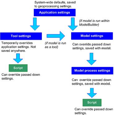
12 ENVIRONMENT SETTINGS There are four levels of environment settings: 1. Application level settings are the default settings that will be applied to any tool when it is executed. 2. Tool level settings are applied to a single run of a tool and override the application level settings. 3. Model level settings are specified and saved with a mode and override tool level and application level settings. 4. Model process level settings are specified at the model process level, are saved with the model, and override model level settings.
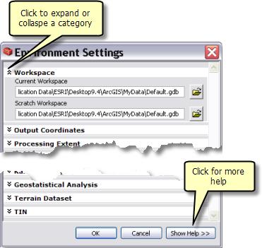
13 ENVIRONMENT SETTINGS


14 EVERY TOOL HAS ENVIRONMENT SETTINGS Tools validate parameter values as you enter them They also can override environment settings

15 BRING THEM UP & EXPAND TO USE

16 OUTPUT COORDINATE SYSTEM


17 PROCESSING EXTENT-> ENV. SETTINGS This is how you force grid concurrency Extent -> Limits Snap aligns


18 RECALL MASKED EXTENTS Rasters that have the same masked extents, simply have the same nodata cells The mask can be derived from a polygon or a raster A concurrent raster mask is the most accurate! From:


19 WHERE TO LEARN MORE ABOUT GEOPROCESSING <- Links on our website Plus, Other Classes ESRI Courses ESRI Tutorials
20 TODAY S PLAN I. Geoprocessing II. ModelBuilder III. Batch Processing I. A right-click away II. Scripting
: http://www.utdallas.edu/~briggs/poec6382/custom.")
21 THE MODELBUILDER INTERFACE ModelBuilder window: where you edit, test and run models ModelBuilder Canvas Run Add Connection Slide from: Torres (2005):
22 MODEL ELEMENTS: Variables: Variables are elements in a model that hold a value or a reference to data stored on disk. There are two types of variables: Data: Data variables are model elements that contain descriptive information about data stored on disk. Properties of data that are described in a data variable include field information, spatial reference, and path. Values: Value variables are values such as strings, numbers, Booleans (true/false values), spatial references, linear units, or extents. Value variables contain anything but references to data stored on disk. Connectors: Connectors connect data and values to tools. The connector arrows show the direction of processing. There are four types of connectors: Data: Data connectors connect data and value variables to tools. Environment: Environment connectors connect a variable containing an environment setting (data or value) to a tool. When the tool is executed, it will use the environment setting. Precondition: Precondition connectors connect a variable to a tool. The tool will execute only after the contents of the precondition variable are created. Feedback: Feedback connectors connect the output of a tool back into the same tool as input.
23 THE MODELBUILDER INTERFACE, CONT. Model elements have 3 states Not ready to run (parameters aren t defined) Input tool output Usually referred to as Derived Data Ready to run (all elements are colored) Already run (elements are colored and shaded) Slide from: Torres (2005):
24 TODAY S PLAN I. Geoprocessing II. ModelBuilder III. Batch Processing I. A right-click away II. Scripting IV. Python Scripting V. Efficiency

25 BRUTE FORCE If you do something once or twice, brute force may suffice If you start doing it more than that, make yourself a tool Limits opportunity for sloppy mistakes Makes If good enough, share it with others
26 BATCH PROCESSING I got to do this same thing 100 times AGHHH Brute force or Batch Process? Use right-click in Arc Toolbox and click batch Write a script that loops through same thing (input varies)
27 TODAY S PLAN I. Geoprocessing II. ModelBuilder III. Batch Processing I. A right-click away II. Scripting

28 ANY GEOPROCESSING TASK: That you think you want to do more then once Just right click

29 THEN. FILL OUT BATCH GRID Add as many rows as you want (batch) Double click on each cell to fill out Copy and Paste from above.
30 TODAY S PLAN I. Geoprocessing II. ModelBuilder III. Batch Processing I. A right-click away II. Scripting
31 SCRIPTING IN GIS Sequences of GIS operations that can be stored and shared Native languages: Arc Macro Language, Avenue Software independent languages such as Visual Basic for Applications, Perl, or Python a model can be written and executed as a script Scripts can be manipulated visually e.g., through ESRI's ModelBuilder
 Loops")
32 PROGRAMMING? Lots of languages (syntax is critical to speak) Loops (for or do) Conditional (if, then, else)
33 PROGRAMMING - LOOPS
 and then Export -> To Python Script 2.")
34 BUT I DON T KNOW HOW TO CODE? Three simple tricks to learning: 1. Build a model (visually) and then Export -> To Python Script 2. Try Geoprocessing Results -> Copy as Python Snippet 3. Python scripting window and help!


35 1. OPEN IT UP AND READ IT Try and run it at command prompt!

36 2. COPY AS PYTHON SNIPPET The snippet shows the syntax for any geoprocessing command you just ran

37 3. PYTHON WINDOW Start typing & let auto-complete help Then tab select then tab Type dot.

38 3. PYTHON WINDOW Start typing first few letters of command Then tab select then tab Type, & fill out:

39 3. PYTHON WINDOW Then run it It runs, shows you status, saves to geoprocessing results, and adds to display
40 JUST PLAY. If you really want to learn this stuff: Find a problem you need to solve, have a play, try to bolt pieces together, try to get it to work Lots of help and forums and examples to draw off of OR: Take Python Class in Fall (WILD 6900) 5 week espresso course Take Ethan White s BIOL 4040/6040 Python Programming for Biologists in Fall
41 TODAY S PLAN I. Geoprocessing II. ModelBuilder III. Batch Processing I. A right-click away II. Scripting
Analysis & Geoprocessing: Case Studies Problem Solving
 Analysis & Geoprocessing: Case Studies Problem Solving Shawn Marie Simpson Federal User Conference 2008 3 Overview Analysis & Geoprocessing Review What is it? How can I use it to answer questions? Case
AGENDA. Effective Geodatabase Management. Presentation Title. Using Automation. Mohsen Kamal. Name of Speaker Company Name
 AGENDA Effective Geodatabase Management Presentation Title Using Automation Mohsen Kamal Name of Speaker Company Name Agenda Introducing the geodatabase What is a Schema? Schema Creation Options Geoprocessing
Spatial Analysis with ArcGIS Pro. Krithica Kantharaj, Esri
 Spatial Analysis with ArcGIS Pro Krithica Kantharaj, Esri What is analysis? Analysis transforms raw data into information or knowledge Spatial analysis does this for geographic or spatial data Who? What?
EDUCATION GIS CONFERENCE Geoprocessing with ArcGIS Pro. Rudy Prosser GISP CTT+ Instructor, Esri
 EDUCATION GIS CONFERENCE Geoprocessing with ArcGIS Pro Rudy Prosser GISP CTT+ Instructor, Esri Maintenance What is geoprocessing? Geoprocessing is - a framework and set of tools for processing geographic
UNIGIS University of Salzburg. Module: ArcGIS for Server Lesson: Online Spatial analysis UNIGIS
 1 Upon the completion of this presentation you should be able to: Describe the geoprocessing service capabilities Define supported data types input and output of geoprocessing service Configure a geoprocessing
Fundamentals of ModelBuilder
 Fundamentals of ModelBuilder Agenda An Overview of Geoprocessing Framework Introduction to ModelBuilder Basics of ArcToolbox Using ModelBuilder Documenting Models Sharing Models with Others Q & A Geoprocessing
An Introduction to Geoprocessing
 An Introduction to Geoprocessing 1 Geoprocessing What is Geoprocessing What are Geoprocessing Models 2 What is Geoprocessing? Geoprocessing is the processing of geographic information, one of the basic
Session 3: Python Geoprocessing
 Session 3: Python Geoprocessing In this session we use ArcGIS geoprocessing tools in the Python window. Typically you first set your environment and extensions. For example, copy (Ctrl-C) following from
ModelBuilder Getting Started
 2013 Esri International User Conference July 8 12, 2013 San Diego, California Technical Workshop ModelBuilder Getting Started Matt Kennedy Esri UC2013. Technical Workshop. Agenda Geoprocessing overview
Using the ModelBuilder of ArcGIS 9 for Landscape Modeling
 Using the ModelBuilder of ArcGIS 9 for Landscape Modeling Jochen MANEGOLD, ESRI-Germany Geoprocessing in GIS A geographic information system (GIS) provides a framework to support planning tasks and decisions,
GIS Module GMS 7.0 TUTORIALS. 1 Introduction. 1.1 Contents
 GMS 7.0 TUTORIALS 1 Introduction The GIS module can be used to display data from a GIS database directly in GMS without having to convert that data to GMS data types. Native GMS data such as grids and
v. 8.0 GMS 8.0 Tutorial GIS Module Shapefile import, display, and conversion Prerequisite Tutorials None Time minutes
 v. 8.0 GMS 8.0 Tutorial Shapefile import, display, and conversion Objectives Learn how to import and display shapefiles with and without ArcObjects. Convert the shapefiles to GMS feature objects. Prerequisite
Analysis and Geoprocessing Sessions and Demo Theater Presentations
 Esri User Conference 2018 Analysis and Geoprocessing Sessions and Demo Theater Presentations TUESDAY 7/10 -------------------------------------------------------------------------------------------------------------------------------------------
Provides the data analysis, management and
 Leveraging g the Geoprocessing Framework in ArcGIS Engine in.net (Best Practices) Jason Pardy Corey Tucker UC 2006 Tech Session 1 Workshop Outline What is Geoprocessing Accessing and Running Geoprocessing
GEOGRAPHIC MODELLING AND ANALYSIS
 GEOGRAPHIC MODELLING AND ANALYSIS I. INTRODUCTION A. Background Geographic Information System is organized within a GIS so as to optimize the convenience and efficiency with they can be used. To distinguish
Network Analyst: Automating Workflows with Geoprocessing
 Esri International User Conference San Diego, California Technical Workshops July 25, 2012 Network Analyst: Automating Workflows with Geoprocessing Deelesh Mandloi Patrick Stevens Introductions Who are
ArcGIS Pro: What s New in Analysis. Rob Elkins
 ArcGIS Pro: What s New in Analysis Rob Elkins ArcGIS Pro Welcome ArcGIS Pro: Analysis Rob Elkins ArcGIS Pro 1.0 Now Available = + Includes the complete ArcGIS Platform Application fusion Single, always
Objectives Learn how to import and display shapefiles with and without ArcObjects. Learn how to convert the shapefiles to GMS feature objects.
 v. 10.1 GMS 10.1 Tutorial Importing, displaying, and converting shapefiles Objectives Learn how to import and display shapefiles with and without ArcObjects. Learn how to convert the shapefiles to GMS
ArcGIS Pro: Scripting with Python. John Jennifer Duerr:
 ArcGIS Pro: Scripting with Python John Yaist: jyaist@esri.com @TheMaphaps Jennifer Duerr: jduerr@esri.com Target Audience Experienced ArcGIS Desktop Users Experienced with Python Scripting Curious about
Building Java Apps with ArcGIS Runtime SDK
 Building Java Apps with ArcGIS Runtime SDK Vijay Gandhi, Elise Acheson, Eric Bader Demo Source code: https://github.com/esri/arcgis-runtime-samples-java/tree/master/devsummit-2014 Video Recording: http://video.esri.com
THE LIST USABILITY PUG 2007
 THE LIST USABILITY PUG 2007 Layer/Map Management Working with many layers, maps and data sets Direction that ESRI is taking with the Geodatabase Information Model Direction that ESRI is taking with GIS
Objectives Learn how to import and display shapefiles in GMS. Learn how to convert the shapefiles to GMS feature objects. Required Components
 v. 10.3 GMS 10.3 Tutorial Importing, displaying, and converting shapefiles Objectives Learn how to import and display shapefiles in GMS. Learn how to convert the shapefiles to GMS feature objects. Prerequisite
ArcGIS Pro: What s New in Analysis
 Federal GIS Conference February 9 10, 2015 Washington, DC ArcGIS Pro: What s New in Analysis James Sullivan What is analysis? Analysis transforms raw data into information or knowledge. Spatial analysis
ArcGIS Runtime SDK for Java: Building Applications. Eric
 ArcGIS Runtime SDK for Java: Building Applications Eric Bader @ECBader Agenda ArcGIS Runtime and the SDK for Java How to build / Functionality - Maps, Layers and Visualization - Geometry Engine - Routing
How to put the Image Services in the Living Atlas to Work in Your GIS. Charlie Frye, Chief Cartographer Esri, Redlands
 How to put the Image Services in the Living Atlas to Work in Your GIS Charlie Frye, Chief Cartographer Esri, Redlands Image Services in the Living Atlas of the World Let s have a look: https://livingatlas.arcgis.com
Geography 281 Map Making with GIS Project Ten: Mapping and Spatial Analysis
 Geography 281 Map Making with GIS Project Ten: Mapping and Spatial Analysis This project introduces three techniques that enable you to manipulate the spatial boundaries of geographic features: Clipping
Packaging Projects, Maps and Layers. Shilpi Jain Melanie Summers
 Packaging Projects, Maps and Layers Shilpi Jain Melanie Summers What can be packaged Layer Map Project Layer package (.lypkx) Tile package (.tpk) Scene layer package (.slpk) Map package (.mpkx) Mobile
ArcGIS Pro: Tips & Tricks
 ArcGIS Pro: Tips & Tricks James Sullivan Solution Engineer Agenda Project Structure/Set Up Data Visualization/Map Authoring Data/Map Exploration Geoprocessing Editing Layouts Sharing Working with the Ribbon
ArcGIS 9 Using ArcGIS StreetMap
 ArcGIS 9 Using ArcGIS StreetMap Copyright 2001 2004 ESRI All Rights Reserved. Printed in the United States of America. The information contained in this document is the exclusive property of ESRI. This
Remote Sensing in an
 Chapter 6: Displaying Data Remote Sensing in an ArcMap Environment Remote Sensing Analysis in an ArcMap Environment Tammy E. Parece Image source: landsat.usgs.gov Tammy Parece James Campbell John McGee
ARC HYDRO GROUNDWATER TUTORIALS
 ARC HYDRO GROUNDWATER TUTORIALS Subsurface Analyst Creating ArcMap cross sections from existing cross section images Arc Hydro Groundwater (AHGW) is a geodatabase design for representing groundwater datasets
Esri UC 2014 Technical Workshop
 Introduction to Parcel Fabric Amir Plans Parcels Control 1 Points 1-1 Line Points - Lines Editing and Maintaining Parcels using Deed Drafter and ArcGIS Desktop What is a parcel fabric? Dataset of related
Lab Assignment 5 Geoprocessing Service. Due Date: 01/24/2014
 Lab Assignment 5 Geoprocessing Service Due Date: 01/24/2014 Overview Geoprocessing is one of the original purposes or functions when GIS was invented. It provides tools and a framework for performing analysis
06/17/02 Page 1 of 12
 Understanding the Graphical User Interface When you start AutoCAD, the AutoCAD window opens. The window is your design work space. It contains elements that you use to create your designs and to receive
GIS Programming Practicuum
 New Course for Fall 2009 GIS Programming Practicuum Geo 599 2 credits, Monday 4:00-5:20 CRN: 18970 Using Python scripting with ArcGIS Python scripting is a powerful tool for automating many geoprocessing
A Server-Based Tool for Automating MODFLOW Simulations for Well Permitting Decision Support
 Brigham Young University BYU ScholarsArchive All Theses and Dissertations 2012-07-09 A Server-Based Tool for Automating MODFLOW Simulations for Well Permitting Decision Support David J. Jones Brigham Young
Stratigraphy Modeling Boreholes and Cross. Become familiar with boreholes and borehole cross sections in GMS
 v. 10.3 GMS 10.3 Tutorial Stratigraphy Modeling Boreholes and Cross Sections Become familiar with boreholes and borehole cross sections in GMS Objectives Learn how to import borehole data, construct a
Principles and Applications of Microfluidic Devices AutoCAD Design Lab - COMSOL import ready
 Principles and Applications of Microfluidic Devices AutoCAD Design Lab - COMSOL import ready Part I. Introduction AutoCAD is a computer drawing package that can allow you to define physical structures
Drawing and Assembling
 Youth Explore Trades Skills Description In this activity the six sides of a die will be drawn and then assembled together. The intent is to understand how constraints are used to lock individual parts
Section 1. Introduction and Review. Objectives: Log on to the computer Launch AutoCAD Create, open, and save a drawing Review AutoCAD basics
 Section 1 Introduction and Review Objectives: Log on to the computer Launch AutoCAD Create, open, and save a drawing Review AutoCAD basics Drawing Assignments: NCAA Basketball Court Plot Style Table (Check-off)
An Introduction to Dimensioning Dimension Elements-
 An Introduction to Dimensioning A precise drawing plotted to scale often does not convey enough information for builders to construct your design. Usually you add annotation showing object measurements
ARCGIS DESKTOP DEMO (GEOCODING, SERVICE AREAS, TABULAR & SPATIAL JOINS)
") ARCGIS DESKTOP DEMO (GEOCODING, SERVICE AREAS, TABULAR & SPATIAL JOINS) Indiana State GIS Day Conference: September 22, 2015 ASHLEY SUITER GIS Data Analyst Epidemiology Resource Center Indiana State Department
ARCGIS DESKTOP DEMO (GEOCODING, SERVICE AREAS, TABULAR & SPATIAL JOINS) Indiana State GIS Day Conference: September 22, 2015 ASHLEY SUITER GIS Data Analyst Epidemiology Resource Center Indiana State Department
Stratigraphy Modeling Boreholes and Cross Sections
 GMS TUTORIALS Stratigraphy Modeling Boreholes and Cross Sections The Borehole module of GMS can be used to visualize boreholes created from drilling logs. Also three-dimensional cross sections between
White paper brief IdahoView Imagery Services: LISA 1 Technical Report no. 2 Setup and Use Tutorial
 White paper brief IdahoView Imagery Services: LISA 1 Technical Report no. 2 Setup and Use Tutorial Keith T. Weber, GISP, GIS Director, Idaho State University, 921 S. 8th Ave., stop 8104, Pocatello, ID
QUICK-START FOR UNIVERSAL VLS 4.6 LASER! FRESH 21 SEPTEMBER 2017
 QUICK-START FOR UNIVERSAL VLS 4.6 LASER! FRESH 21 SEPTEMBER 2017 The laser is quite safe to use, but it is powerful; using it requires your full caution, attention and respect. Some rules of the road:
QUICK-START FOR UNIVERSAL VLS 4.6 LASER!
 QUICK-START FOR UNIVERSAL VLS 4.6 LASER! The laser is quite safe to use, but it is powerful; using it requires your full caution, attention and respect. Some rules of the road: Rules of the road If you
Raster is faster but vector is corrector
 Account not required Raster is faster but vector is corrector The old GIS adage raster is faster but vector is corrector comes from the two different fundamental GIS models: vector and raster. Each of
Getting Started. with Easy Blue Print
 Getting Started with Easy Blue Print User Interface Overview Easy Blue Print is a simple drawing program that will allow you to create professional-looking 2D floor plan drawings. This guide covers the
MODULE 1 HAZARDOUS EMERGENCY DECISIONS
 MODULE INTRODUCTION Accidents, natural disasters, and terrorism produce chaotic homeland security situations that require a coordinated response based on sound information. GIS, when applied to these emergencies,
Public Safety Geocoding Using ArcGIS Online and HERE Data
 Public Safety Geocoding Using ArcGIS Online and HERE Data I. Knowledge, Skills, and Abilities (KSAs) Supported This training module aids in the development of several KSAs that are fundamental to using
1.NBT Number Square. Task. Alignments to Content Standards: 1.NBT.C.5. Part 1. The teacher explains the Number Square:
 1.NBT Number Square Alignments to Content Standards: 1.NBT.C.5 Task Part 1 The teacher explains the Number Square: In this big number square, the numbers in the little individual boxes get bigger by one
in ArcMap By Mike Price, Entrada/San Juan, Inc.
 Interactively Create and Apply Logarithmic Legends in ArcMap By Mike Price, Entrada/San Juan, Inc. This exercise uses the dataset for Battle Mountain, Nevada, that was used in previous exercises. The Geochemistry
Using QuickBird Imagery in ESRI Software Products
 Using QuickBird Imagery in ESRI Software Products TABLE OF CONTENTS 1. Introduction...2 Purpose Scope Image Stretching Color Guns 2. Imagery Usage Instructions...4 ArcView 3.x...4 ArcGIS...7 i Using QuickBird
Digital Design and Communication Teaching (DiDACT) University of Sheffield Department of Landscape. Adobe Photoshop CS5 INTRODUCTION WORKSHOPS
 University of Sheffield Department of Landscape. Adobe Photoshop CS5 INTRODUCTION WORKSHOPS") Adobe INTRODUCTION WORKSHOPS WORKSHOP 1 - what is Photoshop + what does it do? Outcomes: What is Photoshop? Opening, importing and creating images. Basic knowledge of Photoshop tools. Examples of work.
Adobe INTRODUCTION WORKSHOPS WORKSHOP 1 - what is Photoshop + what does it do? Outcomes: What is Photoshop? Opening, importing and creating images. Basic knowledge of Photoshop tools. Examples of work.
Hydraulics and Floodplain Modeling Managing HEC-RAS Cross Sections
 WMS 10.1 Tutorial Hydraulics and Floodplain Modeling Managing HEC-RAS Cross Sections Modify cross sections in an HEC-RAS model to use surveyed cross section data v. 10.1 Objectives Build a basic HEC-RAS
This section will take you through the process of drawing an oblique block. Your entire part, in all views, should look like Figure 1.
 Oblique Block Preface This section will take you through the process of drawing an oblique block. Your entire part, in all views, should look like Figure 1. Figure 1 68 / 3D Scripted Drawings: Oblique
Remote Sensing in an
 Chapter 15: Spatial Enhancement of Landsat Imagery Remote Sensing in an ArcMap Environment Remote Sensing Analysis in an ArcMap Environment Tammy E. Parece Image source: landsat.usgs.gov Tammy Parece James
Getting Started. Before You Begin, make sure you customized the following settings:
 Getting Started Getting Started Before getting into the detailed instructions for using Generative Drafting, the following tutorial aims at giving you a feel of what you can do with the product. It provides
Lab 3: Introduction to Image Analysis with ArcGIS 10
 Lab 3: Introduction to Image Analysis with ArcGIS 10 Peter E. Price TerraView 2010 Peter E. Price All rights reserved. Revised 03/2011. Revised for Geob 373 by BK Feb 7, 2017. V9 The information contained
Using Imagery for Intelligence Analysis. Jim Michel Renee Bernstein
 Using Imagery for Intelligence Analysis Jim Michel Renee Bernstein Deriving Value from GIS and Imagery Capabilities Evolved Along Separate but Parallel Paths GIS Imagery brings value Imagery Contextual
84 part video tutorial training course. The course is 100% free with no catches or exclusions. You don
 Please Note: If you're new to Revit, you may be interested in my " Beginner's Guide to Revit Architecture " 84 part video tutorial training course. The course is 100% free with no catches or exclusions.
Photoshop CS6 First Edition
 Photoshop CS6 First Edition LearnKey provides self-paced training courses and online learning solutions to education, government, business, and individuals world-wide. With dynamic video-based courseware
Illustrative Mathematics. Alignments to Content Standards: 4.OA.B. Task. Below is a multiplication table for single digit numbers:
 4.OA Identifying Multiples Alignments to Content Standards: 4.OA.B Task Below is a multiplication table for single digit numbers: 1 Use a different copy of the multiplication table for each of the questions
Vectorworks / MiniCAD Tutorials
 Vectorworks / MiniCAD Tutorials Tutorial 1: Construct a simple model of a little house Tutorial 2: Construct a 4 view Orthographic drawing of the Model These tutorials are available as Adobe Acrobat 4
Getting Started Guide
 SOLIDWORKS Getting Started Guide SOLIDWORKS Electrical FIRST Robotics Edition Alexander Ouellet 1/2/2015 Table of Contents INTRODUCTION... 1 What is SOLIDWORKS Electrical?... Error! Bookmark not defined.
Using Geoprocessing Services with ArcGIS Web Mapping APIs
 Using Geoprocessing Services with ArcGIS Web Mapping APIs Monica Joseph, Scott Murray Please fill session survey. What is a Geoprocessing Service? A geoprocessing service is a set of geoprocessing tools
GEORGIA WETLANDS TOOL
 GEORGIA WETLANDS TOOL TONY GIARRUSSO ASSOCIATE DIRECTOR & SENIOR RESEARCH SCIENTIST GEORGIA TECH CENTER FOR GIS OUTLINE Project History Overview of NWI Data 2000 Georgia Basemap Wetlands Toolkit Overview
Using 3D thematic symbology to display features in a scene
 Using 3D thematic symbology to display features in a scene www.learn.arcgis.com 380 New York Street Redlands, California 92373 8100 USA Copyright 2018 Esri All rights reserved. Printed in the United States
Spatial Analyst is an extension in ArcGIS specially designed for working with raster data.
 Spatial Analyst is an extension in ArcGIS specially designed for working with raster data. 1 Do you remember the difference between vector and raster data in GIS? 2 In Lesson 2 you learned about the difference
Chapter 2: 3D Character Leads 2D Character
 Chapter 2: 3D Character Leads 2D Character Printing and Pegging Process for 3D leads If you can plan on drawing your 2D with pencil and paper you will need to export 3D images to use as reference. The
Educator s Guide to Cartoon Yourself in Photoshop
 Educator s Guide to Cartoon Yourself in Photoshop Overview: Photoshop is the leading program for editing photos. The aim of this lesson is to help students become more familiar with this industry standard
Expert Raster Editing - Reusing and Updating Your Existing Paper Documents
 11/28/2005-1:00 pm - 2:30 pm Room:N. Hemispheres (Salon E1) (Dolphin) Walt Disney World Swan and Dolphin Resort Orlando, Florida Expert Raster Editing - Reusing and Updating Your Existing Paper Documents
Create a Flowchart in Word
 Create a Flowchart in Word A flowchart is a diagram of steps, movements or actions involved in a system or activity. Flowcharts use conventional geometric symbols and arrows to define relationships and
Creating Geoprocessing Services
 Esri International User Conference San Diego, California Technical Workshops July 25, 2012 Creating Geoprocessing Services Kevin Hibma, Scott Murray Analysis and Geoprocessing Resource Center Quick Links:
1: INTRODUCTION TO AUTOCAD
 AutoCAD syllabus 1: INTRODUCTION TO AUTOCAD Starting AutoCAD AutoCAD Screen Components Drawing Area Command Window Navigation bar Status bar Invoking Commands in AutoCAD Keyboard Ribbon Application Menu
Relative Coordinates
 AutoCAD Essentials Most drawings are created using relative coordinates. This means that the next point is set from the last point drawn. The last point drawn is stored as temporary 0,0". AutoCAD uses
Jupyter Notebook. portal.biohpc.swmed.edu
 Jupyter Notebook [web] [email] portal.biohpc.swmed.edu biohpc-help@utsouthwestern.edu 1 2018-05-16 What is Jupyter Notebook? Jupyter Notebook is an interactive web application that allows users to: Interactively
COMPUTER PACKAGES II
 UNESCO-NIGERIA TECHNICAL & VOCATIONAL EDUCATION REVITALISATION PROJECT-PHASE II NATIONAL DIPLOMA IN COMPUTER TECHNOLOGY AUTOCAD DBMS DTP SPSS COMPUTER PACKAGES II COURSE CODE: COM 215 YEAR 2- SE MESTER
Alex is training for his school's Jog-A-Thon and needs to run at least mile per day. If 5
 .NF Jog-A-Thon Alignments to Content Standards:.NF.A. Task Alex is training for his school's Jog-A-Thon and needs to run at least mile per day. If Alex runs to his grandma's house, which is of a mile away,
Military Tools for ArcGIS: An Introduction. Derek Foll Lyle Wright
 Military Tools for ArcGIS: An Introduction Derek Foll Lyle Wright Defense Solutions Current Capabilities Whole Organization Intelligence Analysis Civil-Military Operations Military Tools for ArcGIS Coordinate
Welcome to Corel DESIGNER, a comprehensive vector-based package for technical graphic users and technical illustrators.
 Workspace tour Welcome to Corel DESIGNER, a comprehensive vector-based package for technical graphic users and technical illustrators. This tutorial will help you become familiar with the terminology and
A Web Application That Can Save You Money
 Esri Southwest Conference December 2-4, 2014 Santa Fe, NM A Web Application That Can Save You Money Colleen Swain, Swain GIS Services, LLC Brian Zheng, East Bay Municipal Utility District Problem Background
ACI Sketch. Copyright October 2008, ACI All Rights Reserved. 24 Old Kings Road North Palm Coast, FL appraiserschoice.com
 ACI Sketch Copyright October 2008, ACI All Rights Reserved 24 Old Kings Road North Palm Coast, FL 32137 appraiserschoice.com 800.234.8727 ACI Sketch Contents Getting Started 1 Working with the Grid 2 Unit
ArcGIS Tutorial: Geocoding Addresses
 U ArcGIS Tutorial: Geocoding Addresses Introduction Address data can be applied to a variety of research questions using GIS. Once imported into a GIS, you can spatially display the address locations and
Introduction to Geoprocessing Scripts Using Python. Student Edition
 Introduction to Geoprocessing Scripts Using Python Student Edition Copyright 2013 Esri All rights reserved. Course version 6.0. Version release date August 2013. Printed in the United States of America.
The image regions are all in focus, producing no contrast resulting from changes in signal level.
 StreamLineHR example Figure 6. Raman image of angled grid with no surface correction (5 µm step size, 50 objective). The bright image regions are in focus, darker regions are out of focus. (The centre
IT154 Midterm Study Guide
 IT154 Midterm Study Guide These are facts about the Adobe Photoshop CS4 application. If you know these facts, you should be able to do well on your midterm. Photoshop CS4 is part of the Adobe Creative
Key Terms. Where is it Located Start > All Programs > Adobe Design Premium CS5> Adobe Photoshop CS5. Description
 Adobe Adobe Creative Suite (CS) is collection of video editing, graphic design, and web developing applications made by Adobe Systems. It includes Photoshop, InDesign, and Acrobat among other programs.
Version 9 Tutorial and User Guide
 Version 9 Tutorial and User Guide 800-989-4243 214-340-9436 support@vertigraph.com www.vertigraph.com 1 Table of Contents A. Overview... 4 B. About the SiteWorx/OS Window... 4 C. File Types Raster, Vector
Quick Guide for ArcReader GIS Installation & Use
 Town of Hanover Planning Department Quick Guide for ArcReader GIS Installation & Use For more information, contact the Town Planner, Andrew Port (781-826-7641) or port.planning@hanover-ma.gov System Requirements
Lab Exercise 6: Vector Spatial Analysis
 Massachusetts Institute of Technology Department of Urban Studies and Planning 11.520: A Workshop on Geographic Information Systems 11.188: Urban Planning and Social Science Laboratory Lab Exercise 6:
Bolder Sounds. Bavarian Zither version 2. presents. for NI Kontakt 2 + (600 mb) Kontakt Installation
 Kontakt Installation") Bolder Sounds presents Bavarian Zither version 2 for NI Kontakt 2 + (600 mb) Kontakt Installation Before you do anything else - please make a backup copy of the package you have downloaded! 1. The Bavarian_Zither.rar
Bolder Sounds presents Bavarian Zither version 2 for NI Kontakt 2 + (600 mb) Kontakt Installation Before you do anything else - please make a backup copy of the package you have downloaded! 1. The Bavarian_Zither.rar
Qt Developing ArcGIS Runtime Applications. Eric
 Qt Developing ArcGIS Runtime Applications Eric Bader @ECBader Agenda Getting Started Creating the Map Geocoding and Routing Geoprocessing Message Processing Working Offline The Next Release What s Coming
Rapid Airfield Construction Decision Support Toolset
 Rapid Airfield Construction Decision Support Toolset Scott Bourne ERDC Scott.Bourne@erdc.usace.army.mil 601-634-3980 Introduction One of the greatest challenges to the U.S. Army s Rapid Deployment concept
Geocoding and Address Matching
 LAB PREP: Geocoding and Address Matching Environmental, Earth, & Ocean Science 381 -Spring 2015 - Geocoding The process by which spatial locations are determined using coordinate locations specified in
Managing Imagery and Raster Data. Peter Becker
 Managing Imagery and Raster Data Peter Becker ArcGIS is a Comprehensive Imagery Platform Empowering you to make informed decisions System of Engagement System of Insight Extract Information from Imagery
ADOBE PHOTOSHOP CS 3 QUICK REFERENCE
 ADOBE PHOTOSHOP CS 3 QUICK REFERENCE INTRODUCTION Adobe PhotoShop CS 3 is a powerful software environment for editing, manipulating and creating images and other graphics. This reference guide provides
Between a Rock and a Hard Place
 Between a Rock and a Hard Place Will Cadell & Chris Hermansen Timberline Natural Resource Group Pt 2 1 Challenges: Proprietary Integration Open Source Integration Open Source Application To continue on
To-Do List: Initial steps upon opening an.ai document that has been exported from ArcMap
 To-Do List: Initial steps upon opening an.ai document that has been exported from ArcMap 1. Update labels. 2. Release all clipping masks and delete the mask. 3. Ungroup all items. 4. Update font sizes.
in the list below are available in the Pro version of Scan2CAD
 Scan2CAD features Features marked only. in the list below are available in the Pro version of Scan2CAD Scan Scan from inside Scan2CAD using TWAIN (Acquire). Use any TWAIN-compliant scanner of any size.