Geocoding Techniques and Options for US and International Locations
|
|
|
- Darren Grant
- 6 years ago
- Views:
Transcription

1 Federal GIS Conference 2014 February 10 11, 2014 Washington DC Geocoding Techniques and Options for US and International Locations Tosia Shall, Esri Doug Geverdt, Census Chuck Whittington, Census


2 Types of Geocoding GeoSearch Sydney Opera House Batch Geocoding and Reverse Geocoding?
3 On premises vs Online On premises - Need to geocode behind a firewall for security/privacy reasons - need to maintain your own reference data Online - Users who want to consume a ready-to-use geocoding service
4 Geocoding On-Premises Users that need to geocode behind a firewall for security/privacy reasons Users that maintain their own reference data What you need: Hardware/Device to host data and locators ArcGIS Software Locator Files and Reference Data or a Private Geocoding Service

5 Options Obtain or create reference data, build your own locator Use locators in Esri s ready to use street data product, StreetMap Premium - North America - Latin America - Europe - Australia/New Zealand - Japan License by: Continent Country State/Province (US/Canada)
6 Geocoding On-Line the ArcGIS Online World Geocoding Service Ready-to-use world geocoding service Covers: - the planet at Admin/Populated places level countries supported at address precision - 55 countries down to address point Numbers to remember for batch geocoding: 40 credits for every 1,000 geocodes 2.4 credits per 10 MB of stored feature services/month
7 Which option is for me? I am a user based in the US that needs to geocode tens of millions of US addresses per year, which option is right for me? On premises option may be best IF Volume of geocodes expected Cost of credits consumed using the ArcGIS Online World Geocoding Service


8 Which option is for me? I am a global, enterprise organization that needs to geocode addresses worldwide, what should I use? World Geocoding Service IF your geocoding region extends beyond StreetMap Premium availability North America Latin America Europe Japan Australia/New Zealand


9 Which option is for me? I need to geocode millions of North American addresses per month, yet I have a hundred records for other countries I need geocoded as well, what should I use? Hybrid! StreetMap Premium + World Geocoding Service
10 Geocoding: A Hybrid Approach Doug Geverdt, US Census Bureau, Governments Division
11 Organizational Context Census Bureau - substantial collaboration with other federal agencies Support U.S. Dept. of Education s National Center for Education Statistics (NCES) (more than a dozen projects, large and small) Education Demographic and Geographic Estimates project (EDGE) Create custom demographic and geographic data products to help NCES identify and report on the conditions of education in the U.S. Demographic (custom tabulations from American Community Survey) School district demographics for school-age children Experimental school-level estimates Geographic School address geocodes Other geographic associations (county, Congressional District, etc.) Locale indicators
12 NCES Locale Geography Source: NCES locale criteria applied to 2013 Census TIGER/Line

13 Source: NCES locale criteria applied to 2013 Census Urban Change: Rural to Non-Rural Schools ( )
14 Operational Context One-person operation Limited budget and time Cyclical but unstable product schedule Low volume (max file size 100k cases) High need for spatial accuracy Needs: Low cost Low hassle Spatially accurate Distributable Results publicly available IT environment: Project-level: ArcGIS and SAS for analysis/review Enterprise-level: ESRI site license; high bar to approve new software
15 Basic Workflow Receive and review annually updated address files Geocode (multiple sources) and integrate results Synthesize current-year results with prior-year data Review, edit, and finalize results (file curation) Create indicators and supplemental associations Geo data elements delivered and included in primary data products
16 Solutions Phase 1 (2007): ArcWeb Services - Online flexibility, Cost effective (low volume), multiple sources Phase 2 (2010): ArcGIS Online - Increase manual review with AGO base layers, Public search (Google Earth, Wikis, etc.) Phase 3 (2013): StreetMap Premium (SMP) and ArcGIS Online - Better value for unpredictable volume, more control/flexibility, multiple sources Phase 4 (future): Increasingly Multi-Modal - Current automated resources (SMP+AGO), systematic manual review, federal sources, local level respondents (district personnel, students)
17 Challenges How to spend less time Improving address quality Improving positional accuracy to get better data so we have more time to use it Rooftop result may not be building footprint Address point may be parcel centroid worse than old point Interpreting year-to-year location changes for stable addresses Explaining the role of good geo data for good demographic analysis Managing assumptions and expectations about automated geocoding
18 Geocoding: A Hybrid Approach Doug Geverdt, US Census Bureau, Governments Division


19 Accessing the World Geocoding Service - Desktop Organization username Password


20 Accessing the World Geocoding Service Web Apps


21 Batch Geocoding in ArcGIS Online


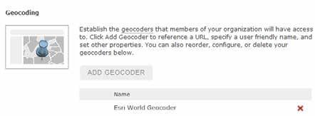
22 Registering your own Geocoding Service in ArcGIS Online
23 What s else is new? Location can be used to provide local context for Geosearch or Interactive geocoding Web Apps can leverage the center of the map or the IP location Mobile Apps can leverage the GPS location A peek into the future Interactive re-matching capabilities in ArcGIS Online!
24 Geocoding Services Capability Update Chuck Whittington, US Census Bureau, Geography Division

25 Geocoding Service Functional Core Capabilities Single Address Geocoding through a web service - Input: House Number, Street Name, City, State and/or Zip Code - Returns matched address, lat/long, state, county, tract, and block codes

26 Geocoding Service Functional Core Capabilities Batch Geocoding - Input: User provided delimited text file of addresses - Returns a delimited text file automatically launched from the web containing - Matched addresses - Lat/Long coordinates - TIGER/Line ID at right/left side - State, County, Tract, and Block codes - Other higher levels of geography in a future release - *NOTE: Not Title 13 data

27 Geocoding Service Functional Core Capabilities Geography Look-up Service - Input: Lat/Long coordinate - Returns State, County, Tract, Block. Will add other geographies in the future
28 Current Status Completed internal production release of Address Range based service supporting 2014 Census site test recruiting and applicant geocoding Refine requirements, architecture and design External facing Address Range based service initial release in March 2014 MAF based service FY14 starting planning for implementation of the solution


29 Geocoding Services Capability Update Chuck Whittington, US Census Bureau, Geography Division


30
Geocoding Techniques and Options for US and International Locations
 Federal GIS Conference February 9 10, 2015 Washington, DC Geocoding Techniques and Options for US and International Locations Tosia Shall Esri, Washington, DC James Tedrick Esri, Washington, DC Chris Sheldrick
ArcGIS Online Content
 Esri International User Conference San Diego, California Technical Workshops July 25, 2012 ArcGIS Online Content Deane Kensok Sarah Osborne Today s Agenda Overview Esri Content Portfolio - What s Available,
Geocoding Techniques and Options for US and International Locations. Thomas Oaks Tosia Shall
 Geocoding Techniques and Options for US and International Locations Thomas Oaks Tosia Shall Agenda Geocoding Overview and Requirements Geocoding in Desktop Geocoding with a Service What is Geocoding? A
ArcGIS Geocoding What s New and the Road Ahead. Jeff Rogers Brad Niemand
 ArcGIS Geocoding What s New and the Road Ahead Jeff Rogers Brad Niemand Agenda Overview - ArcGIS Platform Geocoding - ArcGIS Geocoding Solutions What s New - On-Premises Geocoding Solutions - Desktop Geocoding
Geocoding An Introduction
 2013 Esri International User Conference July 8 12, 2013 San Diego, California Technical Workshop Geocoding An Introduction Miriam Schmidts Agatha Wong Esri UC2013. Technical Workshop. Agenda What is geocoding?
Geocoding with ArcGIS FedGIS 2017 (2/14/2017)
") Geocoding with ArcGIS FedGIS 2017 (2/14/2017) Michael Rink, Esri Nick Patel, Esri Agenda Introduction Building a Robust Global Geocoding Experience Overview of Esri s Geocoding products Road Ahead Demo
Geocoding with ArcGIS FedGIS 2017 (2/14/2017) Michael Rink, Esri Nick Patel, Esri Agenda Introduction Building a Robust Global Geocoding Experience Overview of Esri s Geocoding products Road Ahead Demo
The 2020 Census Geographic Partnership Opportunities. Geography Division U.S. Census Bureau
 The 2020 Census Geographic Partnership Opportunities Geography Division U.S. Census Bureau Legal Legal entities originate from legal actions, treaties, statutes, ordinances, resolutions, court decisions,
In-Office Address Canvassing for the 2020 Census: an Overview of Operations and Initial Findings
 In-Office Address Canvassing for the 2020 Census: an Overview of Operations and Initial Findings Michael Commons Address and Spatial Analysis Branch Geography Division U.S. Census Bureau In-Office Address
The 2020 Census Geographic Partnership Opportunities
 The 2020 Census Geographic Partnership Opportunities Web Adams Geographer, U.S. Census Bureau New York Regional Office 1 Geographic Partnership Opportunities The 2020 Census Local Update of Census Addresses
Geocoding DoubleCheck: A Unique Location Accuracy Assessment Tool for Parcel-level Geocoding
 Measuring, Modelling and Mapping our Dynamic Home Planet Geocoding DoubleCheck: A Unique Location Accuracy Assessment Tool for Parcel-level Geocoding Page 1 Geocoding is a process of converting an address
ArcGIS Online: World Geocoding. Bruce Harold, Esri
 ArcGIS Online: World Geocoding Bruce Harold, Esri bharold@esri.com Nick Patel, Esri npatel@esri.com Agenda Introduction Benefits of Esri World Geocoding Overview of Esri s World Geocoding products What
The 2020 Census Geographic Partnership Opportunities
 The 2020 Census Geographic Partnership Opportunities Brian Timko Branch Chief Address Data Collection and Products Branch Geography Division U.S. Census Bureau 1 Geographic Partnership Opportunities The
The U.S. Decennial Census A Brief History
 1 The U.S. Decennial Census A Brief History Under the direction of then Secretary of State, Thomas Jefferson, the first U.S. Census began on August 2, 1790, and was to be completed by April 1791 The total
US Census. Thomas Talbot February 5, 2013
 US Census Thomas Talbot February 5, 2013 Outline Census Geography TIGER Files Decennial Census - Complete count American Community Survey Yearly Sample Obtaining Data - American Fact Finder - Census FTP
CRA Wiz & Fair Lending Wiz Geocoding Basics. August 2017
 CRA Wiz & Fair Lending Wiz Geocoding Basics August 2017 CRA Wiz & Fair Lending Wiz Recommended Geocoding Settings & Fall Back Options Geocoding Match Types Parcel Matches Street Matches Tract Matches ZIP
Improving the Quality of Geocoded Data
 Improving the Quality of Geocoded Data NCCCP & NPCR Conference April 15, 2009 Kevin C. Ward, PhD, CTR Georgia Center for Cancer Statistics Census Geography Geographic Unit State County Census Tract (average
Realigning Historical Census Tract and County Boundaries
 Realigning Historical Census Tract and County Boundaries David Van Riper Research Fellow Minnesota Population Center University of Minnesota Twin Cities dvanriper@gmail.com Stanley Dallal ESEA dallal@esea.com
Using Location-Based Services to Improve Census and Demographic Statistical Data. Deirdre Dalpiaz Bishop May 17, 2012
 Using Location-Based Services to Improve Census and Demographic Statistical Data Deirdre Dalpiaz Bishop May 17, 2012 U.S. Census Bureau Mission To serve as the leading source of quality data about the
Overview of Demographic Data
 Overview of Demographic Data Michael Ratcliffe Geography Division US Census Bureau Mapping Sciences Committee October 20, 2014 Sources of Demographic Data Censuses Full enumeration, or counting, of the
Public Safety Geocoding Using ArcGIS Online and HERE Data
 Public Safety Geocoding Using ArcGIS Online and HERE Data I. Knowledge, Skills, and Abilities (KSAs) Supported This training module aids in the development of several KSAs that are fundamental to using
2020 Census Local Update of Census Addresses Operation (LUCA) U.S. Census Bureau Geography Division
 U.S. Census Bureau Geography Division") 2020 Census Local Update of Census Addresses Operation (LUCA) U.S. Census Bureau Geography Division 1 Agenda 2020 Census LUCA Operation Participation in LUCA What is LUCA? Who Can Participate? Why participate?
2020 Census Local Update of Census Addresses Operation (LUCA) U.S. Census Bureau Geography Division 1 Agenda 2020 Census LUCA Operation Participation in LUCA What is LUCA? Who Can Participate? Why participate?
Copyright The McGraw-Hill Companies, Inc. Permission required for reproduction or display.
 Chapter 16. GEOCODING AND DYNAMIC SEGMENTATION 16.1 Geocoding 16.1.1 Geocoding Reference Database 16.1.2 The Address Matching Process 16.1.3 Address Matching Options Box 16.1 Scoring System for Geocoding
Overview of Census Bureau Geographic Areas and Concepts
 Overview of Census Bureau Geographic Areas and Concepts Drew Stanislaw US Census Bureau WVAGP Annual Meeting Shepherdstown, WV June 13, 2011 1 What is the role of geography in the Census? The Census count
Version 2.2 April Census Local Update of Census Addresses Operation (LUCA) Frequently Asked Questions
 Frequently Asked Questions") Version 2.2 April 2017 2020 Census Local Update of Census Addresses Operation (LUCA) Frequently Asked Questions [This page intentionally left blank] 2020 Census LUCA Frequently Asked Questions TABLE OF
Version 2.2 April 2017 2020 Census Local Update of Census Addresses Operation (LUCA) Frequently Asked Questions [This page intentionally left blank] 2020 Census LUCA Frequently Asked Questions TABLE OF
Geocoding Address Data & Using Geocoded Data
 Geocoding Address Data & Using Geocoded Data This document located at /geocoding.pdf Using this Document & Terms of Use Copyright 2014. ProximityOne. All Rights Reserved. Geocoding Address Data Terms of
Geocoding and Address Matching
 LAB PREP: Geocoding and Address Matching Environmental, Earth, & Ocean Science 381 -Spring 2015 - Geocoding The process by which spatial locations are determined using coordinate locations specified in
2020 Census Geographic Partnership Programs. Update. Atlanta Regional Office Managing Census Operations in: AL, FL, GA, LA, MS, NC, SC
 2020 Census Geographic Partnership Programs Atlanta Regional Office Managing Census Operations in: AL, FL, GA, LA, MS, NC, SC Update Alabama State Data Center Conference Agenda 2020 Census Overview 2020
Lecture 8 Geocoding. Dr. Zhang Spring, 2017
 Lecture 8 Geocoding Dr. Zhang Spring, 2017 Model of the course Using and making maps Navigating GIS maps Map design Working with spatial data Geoprocessing Spatial data infrastructure Digitizing File geodatabases
Analysis and Geoprocessing Sessions and Demo Theater Presentations
 Esri User Conference 2018 Analysis and Geoprocessing Sessions and Demo Theater Presentations TUESDAY 7/10 -------------------------------------------------------------------------------------------------------------------------------------------
Geocoding: Acquiring Location Intelligence to Make Be er Business Decisions
 A M e l i s s a D a t a W h i t e Pa p e r Geocoding: Acquiring Location Intelligence to Make Be er Business Decisions 2 Introduction Geocoding: Acquiring Location Intelligence to Make Better Business
Reverse geocoding and implica1ons for geospa1al privacy. Paul Zandbergen Department of Geography University of New Mexico
 Reverse geocoding and implica1ons for geospa1al privacy Paul Zandbergen Department of Geography University of New Mexico Outline Geospatial privacy Geocoding / reverse geocoding Experimental design Results
Geocoding Techniques and Options for US and International Locations. Brady Hoak, Tosia Shall
 Geocoding Techniques and Options for US and International Locations Brady Hoak, Tosia Shall Agenda What is geocoding? Requirements for Geocoding Preparing Your Data Selecting a Locator Geocoding Process
An ESRI White Paper May 2009 ArcGIS 9.3 Geocoding Technology
 An ESRI White Paper May 2009 ArcGIS 9.3 Geocoding Technology ESRI 380 New York St., Redlands, CA 92373-8100 USA TEL 909-793-2853 FAX 909-793-5953 E-MAIL info@esri.com WEB www.esri.com Copyright 2009 ESRI
Central Cancer Registry Geocoding Needs
 Central Cancer Registry Geocoding Needs John P. Wilson, Daniel W. Goldberg, and Jennifer N. Swift Technical Report No. 13 Central Cancer Registry Geocoding Needs 1 Table of Contents Executive Summary...3
An Introduction to ACS Statistical Methods and Lessons Learned
 An Introduction to ACS Statistical Methods and Lessons Learned Alfredo Navarro US Census Bureau Measuring People in Place Boulder, Colorado October 5, 2012 Outline Motivation Early Decisions Statistical
ARCGIS DESKTOP DEMO (GEOCODING, SERVICE AREAS, TABULAR & SPATIAL JOINS)
") ARCGIS DESKTOP DEMO (GEOCODING, SERVICE AREAS, TABULAR & SPATIAL JOINS) Indiana State GIS Day Conference: September 22, 2015 ASHLEY SUITER GIS Data Analyst Epidemiology Resource Center Indiana State Department
ARCGIS DESKTOP DEMO (GEOCODING, SERVICE AREAS, TABULAR & SPATIAL JOINS) Indiana State GIS Day Conference: September 22, 2015 ASHLEY SUITER GIS Data Analyst Epidemiology Resource Center Indiana State Department
A GI Science Perspective on Geocoding:
 A GI Science Perspective on Geocoding: Accuracy, Repeatability and Implications for Geospatial Privacy Paul A Zandbergen Department of Geography University of New Mexico Geocoding as an Example of Applied
National Longitudinal Study of Adolescent Health. Public Use Contextual Database. Waves I and II. John O.G. Billy Audra T. Wenzlow William R.
 National Longitudinal Study of Adolescent Health Public Use Contextual Database Waves I and II John O.G. Billy Audra T. Wenzlow William R. Grady Carolina Population Center University of North Carolina
How Will the Changing U.S. Census Affect Decision-Making?
 How Will the Changing U.S. Census Affect Decision-Making? David A. Swanson University of California Riverside David.swanson@ucr.edu Prepared for the Lewis Seminar May 15, 2008 ACKNOWLEDGMENTS In addition
Public Safety Routing Using ArcGIS Online and HERE Data
 Public Safety Routing Using ArcGIS Online and HERE Data Knowledge, Skills, and Abilities (KSAs) Supported This training module develops several KSAs that are fundamental to using GIS to support public
The 2010 Census: Count Question Resolution Program
 The 2010 Census: Count Question Resolution Program Jennifer D. Williams Specialist in American National Government December 7, 2012 CRS Report for Congress Prepared for Members and Committees of Congress
Accuracy and Precision of the NAACCR Geocoder. Recinda L Sherman, MPH CTR David J Lee, PhD University of Miami, Florida Cancer Data System
 Accuracy and Precision of the NAACCR Geocoder Recinda L Sherman, MPH CTR David J Lee, PhD University of Miami, Florida Cancer Data System Presentation Overview Overview FCDS Overview Geocoding quality
Participant Statistical Areas Program for the 2010 Census. Vince Osier COPAFS Quarterly Meeting Washington, DC December 8, 2006
 Participant Statistical Areas Program for the 2010 Census Vince Osier COPAFS Quarterly Meeting Washington, DC December 8, 2006 1 Participant Statistical Areas Census Tracts Block Groups Census County Divisions
2010 Census Mapping Evolution, Potentialities and Integration to the National Spatial Data Infrastructure
 2010 Census Mapping Evolution, Potentialities and Integration to the National Spatial Data Infrastructure Miriam Barbuda, MsC LATIN AMERICA GEOSPATIAL FORUM Brazil, Rio de Janeiro, 15-17August 2012 BRAZIL
The American Community Survey. An Esri White Paper August 2017
 An Esri White Paper August 2017 Copyright 2017 Esri All rights reserved. Printed in the United States of America. The information contained in this document is the exclusive property of Esri. This work
Asking Questions on Knowledge Exchange and Exploitation in the Business R&D and Innovation Survey
 Asking Questions on Knowledge Exchange and Exploitation in the Business R&D and Innovation Survey John Jankowski Program Director Research & Development Statistics OECD-KNOWINNO Workshop on Measuring the
Redistricting San Francisco: An Overview of Criteria, Data & Processes
 Redistricting San Francisco: An Overview of Criteria, Data & Processes Karin Mac Donald Q2 Data & Research, LLC October 5, 2011 1 Criteria in the San Francisco Charter: Districts must conform to all legal
The Census Bureau s Master Address File (MAF) Census 2000 Address List Basics
 Census 2000 Address List Basics") The Census Bureau s Master Address File (MAF) Census 2000 Address List Basics OVERVIEW The Census Bureau is developing a nationwide address list, often called the Master Address File (MAF) or the Census
The Census Bureau s Master Address File (MAF) Census 2000 Address List Basics OVERVIEW The Census Bureau is developing a nationwide address list, often called the Master Address File (MAF) or the Census
An Overview of the American Community Survey
 An Overview of the American Community Survey Scott Boggess U.S. Census Bureau 2009 National Conference for Adult Education State Directors Washington, DC March 17, 2009 1 Overview What is the American
American Community Survey Review and Tips for American Fact Finder. Sarah Ehresman Kentucky State Data Center August 7, 2014
 1 American Community Survey Review and Tips for American Fact Finder Sarah Ehresman Kentucky State Data Center August 7, 2014 2 American Community Survey An ongoing annual survey that produces characteristics
2020 Census Participant Statistical Areas Program (PSAP) Overview. Joshua Coutts Geography Division U.S. Census Bureau
 Overview. Joshua Coutts Geography Division U.S. Census Bureau") 2020 Census Participant Statistical Areas Program (PSAP) Overview Joshua Coutts Geography Division U.S. Census Bureau 2020 Census PSAP Allows invited participants to review and update selected statistical
2020 Census Participant Statistical Areas Program (PSAP) Overview Joshua Coutts Geography Division U.S. Census Bureau 2020 Census PSAP Allows invited participants to review and update selected statistical
Knowledge and Data Sharing
 Knowledge and Data Sharing Presented to: American Library Association 2010 Annual Conference Presented by Joey Hutcherson, PMP, TPM, Office of Chief Information Officer, U.S. Department of Commerce Information
The 2020 Census A New Design for the 21 st Century
 The 2020 Census A New Design for the 21 st Century The Decennial Census Purpose: To conduct a census of population and housing and disseminate the results to the President, the States, and the American
National Census Geography Some lessons learned and future challenges in European countries
 UNSD-AITRS Regional Workshop on the Integration of Statistical and Geospatial Information Amman, Jordan, 16-20 February, 2015 National Census Geography Some lessons learned and future challenges in European
South Dakota State Demographic Conference
 10/13/2017 South Dakota State Demographic Conference Role of State Government in Census Related Matters Kevin Iverson, Census Office Manager 328-5385 /ExperienceND /ExperienceND /ExperienceND www.ndcommerce.com
2020 Census Local Update of Census Addresses. Operation (LUCA) Promotion
 Promotion") 2020 Census Local Update of Census Addresses Atlanta Regional Office Managing Census Operations in: AL, FL, GA, LA, MS, NC, SC Operation (LUCA) Promotion 2020 Census Overview What is LUCA? Agenda LUCA
2020 Census Local Update of Census Addresses Atlanta Regional Office Managing Census Operations in: AL, FL, GA, LA, MS, NC, SC Operation (LUCA) Promotion 2020 Census Overview What is LUCA? Agenda LUCA
geocoding crime data in Southern California cities for the project, Crime in Metropolitan
 Technical Document: Procedures for cleaning, geocoding, and aggregating crime incident data John R. Hipp, Charis E. Kubrin, James Wo, Young-an Kim, Christopher Contreras, Nicholas Branic, Michelle Mioduszewski,
GIS Lecture 8: Geocoding
 GIS Lecture 8: Geocoding 100 Elm Street 198 101 199 GIS 1 Outline Geocoding Overview Linear (Street) Geocoding Problems and Solutions Polygon Geocoding Geocoding in ArcGIS GIS 2 Geocoding Overview GIS
Who s in Your Neighborhood? Using the American FactFinder. Salma Abadin and Carrie Koss Vallejo Data You Can Use
 Who s in Your Neighborhood? Using the American FactFinder Salma Abadin and Carrie Koss Vallejo Data You Can Use www.datayoucanuse.org Learning Objectives Learn what American FactFinder is and is not Become
Claritas Demographic Update Methodology Summary
 Claritas Demographic Update Methodology Summary 2006 by Claritas Inc. All rights reserved. Warning! The enclosed material is the intellectual property of Claritas Inc. (Claritas is a subsidiary of VNU,
Country Paper : JAPAN
 Country Paper : JAPAN (a) Why Economic Census? Backgrounds In Japan, censuses and large -scale statistical surveys have been largely divided into major industrial sectors, such as agriculture, forestry
American Community Survey: Sample Design Issues and Challenges Steven P. Hefter, Andre L. Williams U.S. Census Bureau Washington, D.C.
 American Community Survey: Sample Design Issues and Challenges Steven P. Hefter, Andre L. Williams U.S. Census Bureau Washington, D.C. 20233 Abstract In 2005, the American Community Survey (ACS) selected
Reengineering the 2020 Census
 Reengineering the 2020 Census John Thompson Director U.S. Census Bureau Lisa M. Blumerman Associate Director Decennial Census Programs U.S. Census Bureau Presentation to the Committee on National Statistics
Spatial Analysis with ArcGIS Pro. Krithica Kantharaj, Esri
 Spatial Analysis with ArcGIS Pro Krithica Kantharaj, Esri What is analysis? Analysis transforms raw data into information or knowledge Spatial analysis does this for geographic or spatial data Who? What?
2020 Census Local Update of Census Addresses Operation (LUCA)
") 2020 Census Local Update of Census Addresses Operation (LUCA) The Decennial Census The purpose is to conduct a census of population and housing and disseminate results to the President, the States, and
2020 Census Local Update of Census Addresses Operation (LUCA) The Decennial Census The purpose is to conduct a census of population and housing and disseminate results to the President, the States, and
Chapter 10. What is geocoding?
 Chapter 10 Geocoding 10-1 Copyright McGraw-Hill Education. Permission required for reproduction or display. What is geocoding? The process of assigning a location, usually in the form of coordinate values
2020 Census Geographic Partnership Programs. Heidi Crawford Data Dissemination Specialist U.S. Census 1 Bureau
 2017 Oregon Census Data Users Workshop September 20 &21, 2017 2020 Census Geographic Partnership Programs Heidi Crawford Data Dissemination Specialist U.S. Census 1 Bureau Geographic Partnership Opportunities
The 2020 Census: A New Design for the 21 st Century Deirdre Dalpiaz Bishop Chief Decennial Census Management Division U.S.
 The 2020 Census: A New Design for the 21 st Century Deirdre Dalpiaz Bishop Chief Decennial Census Management Division U.S. Census Bureau National Conference of State Legislatures Fall Forum December 9,
Census Data for Grant Writing Workshop Cowlitz-Wahkiakum Council of Governments. Heidi Crawford Data Dissemination Specialist U.S.
 Census Data for Grant Writing Workshop Cowlitz-Wahkiakum Council of Governments Heidi Crawford Data Dissemination Specialist U.S. Census Bureau Agenda Welcome and Introductions Overview of Census Data
Searching, Exporting, Cleaning, & Graphing US Census Data Kelly Clonts Presentation for UC Berkeley, D-lab March 9, 2015
 Searching, Exporting, Cleaning, & Graphing US Census Data Kelly Clonts Presentation for UC Berkeley, D-lab March 9, 2015 Learning Objectives To become familiar with the types of data published by the US
Taming the Census TIGER:
 Taming the Census TIGER: Download TIGER Files using American FactFinder Eric Coyle Data Dissemination Specialist U.S. Census Bureau Outline ACS Overview Census Geography Accessing TIGER/ACS Data Products
2020 CENSUS LOCAL UPDATE OF CENSUS ADDRESSES OPERATION (LUCA) U.S. Census Bureau Geography Division
 U.S. Census Bureau Geography Division") 2020 CENSUS LOCAL UPDATE OF CENSUS ADDRESSES OPERATION (LUCA) U.S. Census Bureau Geography Division 1 Agenda 2020 Census Local Update of Census Addresses Operation (LUCA) Participation in LUCA Why participate
2020 CENSUS LOCAL UPDATE OF CENSUS ADDRESSES OPERATION (LUCA) U.S. Census Bureau Geography Division 1 Agenda 2020 Census Local Update of Census Addresses Operation (LUCA) Participation in LUCA Why participate
GIS Data Sources. Thomas Talbot
 GIS Data Sources Thomas Talbot Chief, Environmental Health Surveillance Section Bureau of Environmental & Occupational Epidemiology New York State Department of Health Outline Sources of Data Census, health,
The Road to 2020 Census
 The Road to 2020 Census Wednesday, May 17 th, 2017 9:00 am-12n North Central Texas Council of Governments 616 Six Flags Drive, Arlington, TX Arlington, TX 1 AGENDA OVERVIEW Decennial Census Basics, 2010
VGIN Geocoding Service
 VGIN Geocoding Service What is Geocoding? Geocoding is the process of assigning geographic coordinates (e.g., latitude and longitude) to data records such as street addresses. With geographic coordinates,
POPULATION AND HOUSING CENSUS MALAYSIA 2010 NEW APPROACHES AND TECHNOLOGICAL ADVANCEMENTS
 POPULATION AND HOUSING CENSUS MALAYSIA 2010 NEW APPROACHES AND TECHNOLOGICAL ADVANCEMENTS l. Introduction 1 A population and housing census represents the principal means of data collection aimed at providing
Dallas Regional Office US Census Bureau
 The Census Bureau: Important Data Products for Every Community Paula Wright, Information Services Specialist Suzee Privett, Information Services Assistant Willie DeBerry, Partnership Specialist Lacey Loftin,
2014 ResearchHack RECAP FOR PAPOR MINI-CONFERENCE. AAPOR s first EVER!!! Jennie Lai, Chuck Shuttles, Anna Wiencrot & Jordon Peugh June 13th, 2014
 2014 ResearchHack RECAP FOR PAPOR MINI-CONFERENCE Jennie Lai, Chuck Shuttles, Anna Wiencrot & Jordon Peugh June 13th, 2014 AAPOR s first EVER!!! BACKGROUND: WHY A HACKATHON? It started with a conversation
The 2020 Census: Preparing for the Road Ahead
 The 2020 Census: Preparing for the Road Ahead Presentation to the National Association of Counties 2017 Annual Conference Columbus, OH July 23, 2017 The Decennial Census Purpose: To conduct a census of
Notes on the 2014 ACS 5-Year Estimates
 Notes on the 2014 ACS 5-Year Estimates Eric Guthrie, Michigan s State Demographer December 3, 2015 The U.S. Census Bureau has released the 2014 American Community Survey (ACS) 5-year estimates. The 5-year
1980 Census 1. 1, 2, 3, 4 indicate different levels of racial/ethnic detail in the tables, and provide different tables.
 1980 Census 1 1. 1980 STF files (STF stands for Summary Tape File from the days of tapes) See the following WWW site for more information: http://www.icpsr.umich.edu/cgi/subject.prl?path=icpsr&query=ia1c
2020 Census Program Update
 2020 Census Program Update Council of Professional Associations on Federal Statistics March 6, 2015 Deirdre Dalpiaz Bishop Chief, Decennial Management Division U.S. Census Bureau 1 Planning for the 2020
2020 Census Local Update of Census Addresses. Operation (LUCA) Promotion
 Promotion") 2020 Census Local Update of Census Addresses Atlanta Regional Office Managing Census Operations in: AL, FL, GA, LA, MS, NC, SC Operation (LUCA) Promotion 2020 Census Overview What is LUCA? Agenda LUCA
2020 Census Local Update of Census Addresses Atlanta Regional Office Managing Census Operations in: AL, FL, GA, LA, MS, NC, SC Operation (LUCA) Promotion 2020 Census Overview What is LUCA? Agenda LUCA
Determining Routing of Wireless Sectors in a Multi PSAP System. Robert Thurston GIS Technician Snohomish County
 Determining Routing of Wireless Sectors in a Multi PSAP 9-1-1 System Robert Thurston GIS Technician Snohomish County Robert Thurston GIS Technician Snohomish County Enhanced 9-1-1 Office Lieutenant with
Analysis & Geoprocessing: Case Studies Problem Solving
 Analysis & Geoprocessing: Case Studies Problem Solving Shawn Marie Simpson Federal User Conference 2008 3 Overview Analysis & Geoprocessing Review What is it? How can I use it to answer questions? Case
ArcGIS Pro: What s New in Analysis
 Federal GIS Conference February 9 10, 2015 Washington, DC ArcGIS Pro: What s New in Analysis James Sullivan What is analysis? Analysis transforms raw data into information or knowledge. Spatial analysis
A Web Application That Can Save You Money
 Esri Southwest Conference December 2-4, 2014 Santa Fe, NM A Web Application That Can Save You Money Colleen Swain, Swain GIS Services, LLC Brian Zheng, East Bay Municipal Utility District Problem Background
Connecting Place: Making Geospatial more Intelligent and Accessible for decision makers. Andrew Coote Chief Executive 3rd February 2013
 Connecting Place: Making Geospatial more Intelligent and Accessible for decision makers Andrew Coote Chief Executive 3rd February 2013 Hype Geospatial Hype Cycle Geo Cloud Crowd Sourcing Augmented Reality
American Community Survey Overview
 American Community Survey Overview ACS Data Users Conference May 11, 2015 Gretchen Gooding American Community Survey Office 1 Outline American Community Survey (ACS) basics Resources for learning more
BLM. Hands on the Land. Training Proposal and Communication Plan. September 2013
 Training Proposal and Communication Plan September 2013 BLM Hands on the Land Training Proposal and Communication Plan Derrick Baldwin Division of Education, Interpretation, and Partnerships Bureau of
Key Census Bureau Economic Programs and Tools
 Key Census Bureau Economic Programs and Tools NY State Data Center Annual Affiliate Meeting May 11, 2017 Presented by: Andrew W. Hait U.S. Census Bureau Outline Overview of Census Economic Data The 2017
ArcGIS 9 Using ArcGIS StreetMap
 ArcGIS 9 Using ArcGIS StreetMap Copyright 2001 2004 ESRI All Rights Reserved. Printed in the United States of America. The information contained in this document is the exclusive property of ESRI. This
2020 Census Participant Statistical Areas Program (PSAP)
") 2020 Census Participant Statistical Areas Program (PSAP) 2020 Census Participant Statistical Areas Program (PSAP) You just finished the LUCA (Local Update of Census Addresses) Program, and now it s time
2020 Census Participant Statistical Areas Program (PSAP) 2020 Census Participant Statistical Areas Program (PSAP) You just finished the LUCA (Local Update of Census Addresses) Program, and now it s time
The Unexpectedly Large Census Count in 2000 and Its Implications
 1 The Unexpectedly Large Census Count in 2000 and Its Implications Reynolds Farley Population Studies Center Institute for Social Research University of Michigan 426 Thompson Street Ann Arbor, MI 48106-1248
Esri UC 2014 Technical Workshop
 Introduction to Parcel Fabric Amir Plans Parcels Control 1 Points 1-1 Line Points - Lines Editing and Maintaining Parcels using Deed Drafter and ArcGIS Desktop What is a parcel fabric? Dataset of related
Poverty in the United Way Service Area
 Poverty in the United Way Service Area Year 2 Update 2012 The Institute for Urban Policy Research At The University of Texas at Dallas Poverty in the United Way Service Area Year 2 Update 2012 Introduction
: Geocode File - Census Tract, Block-Group and Block. Codebook
 196815: Geocode File Census Tract, BlockGroup and Block Codebook Number of Variables 15 Friday June 17 8:49 AM 196815: Geocode File Census Tract, BlockGroup and Block RLS1 "RELEASE NUMBER" NUM(1.) Release
GIS Programming Practicuum
 New Course for Fall 2009 GIS Programming Practicuum Geo 599 2 credits, Monday 4:00-5:20 CRN: 18970 Using Python scripting with ArcGIS Python scripting is a powerful tool for automating many geoprocessing
GPS Accuracy in Urban Environments Using Post-Processed CORS Data
 GPS Accuracy in Urban Environments Using Post-Processed CORS Data Knute A. Berstis, Gerald L. Mader NOAA, NOS, National Geodetic Survey Silver Spring, MD Aaron Jensen US Census Bureau Washington, DC Presentation
Local Update of Census Addresses Program Promotional Workshop
 Local Update of Census Addresses Program Promotional Workshop Will Your Community Be Ready? US Census Bureau Chicago Regional Office Stanley D. Moore, Regional Director 1 Welcome to the Local Update of