GIS Data Sources. Thomas Talbot
|
|
|
- Elwin Cobb
- 6 years ago
- Views:
Transcription
1 GIS Data Sources Thomas Talbot Chief, Environmental Health Surveillance Section Bureau of Environmental & Occupational Epidemiology New York State Department of Health
2 Outline Sources of Data Census, health, environmental, base layers Data Accuracy Data Sharing (NYS GIS Clearinghouse) GIS web services Street Address Mapping (NYS SAM)
3 US Census The US Census is mandated by the Constitution. The population is enumerated every 10 years. Results used to allocate Congressional seats, and government funding. The Census Bureau is responsible for the Census. The first census was taken in 1790, under Secretary of State Thomas Jefferson. For years between decennial census, the Census Bureau makes estimates using the American Community Survey.
4 US Census TIGER Files New York State County - 62 Minor Civil Division (Town) 1,013 Census Tract 4,902 Block Group 15,241 Census Block 350,162

5 Census Geography, Albany County

6 Census Geography, City of Albany
7 Other Census Areas Census designated places Delmar, Slingerlands, Westmere Incorporated villages Voorheesville Altamont Cities Binghamton City ZCTA Native American Reservations School Districts Congressional Districts
8 Other Features in TIGER Transportation features (CFCC Codes) Streets & highways (with street number range & name Railroads Ferry Crossings Foot paths Airports Water features (rivers, lakes, streams, ocean) Other features (landmarks, parks, malls, power lines)
9 Decennial Census Basic demographic information Age Sex Race Ethnicity Number of Housing Units Group Quarters Household relationships
10
11
12 American Community Survey A large, continuous demographic survey 250,000 Households nationwide every month Housing unit address is the sample unit not people Produces annual and multi-year estimates of the characteristics of the population and housing
13 American Community Survey Sample of households. Census views it as producing characteristics distributions, NOT counts Produces information for small areas including tracts, block groups & population subgroups
14 American Community Survey
15 Multiple numbers for the same area Data Release Every Year Period rather than point estimates 2010 release for areas of 65,000 or more 1-year estimate (2009 collection) 3-year estimate ( collection) 5-year estimate ( collection) 2010 release for areas of 20,000 to 65,000 3-year estimate ( collection) 5-year estimate ( collection) 2010 for areas areas under 20,000 5-year estimate ONLY ( )
16
17
18
19
20
21
22
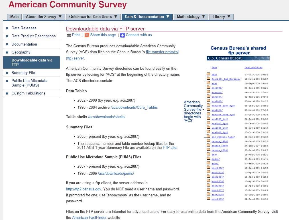
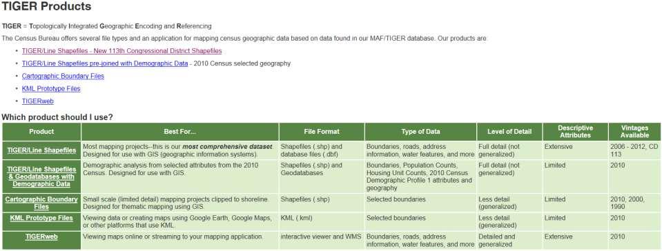
23 FTP S

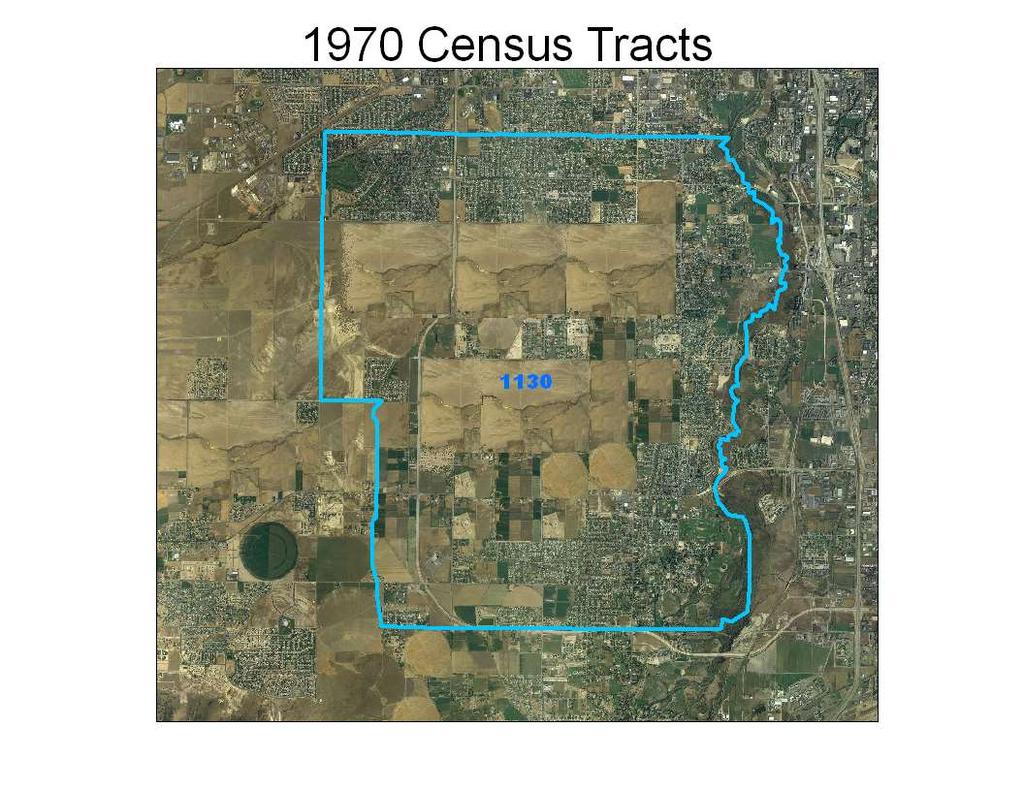
24 FTP Site Provides Comma Separated Value (CSV) Files Data which can imported into spreadsheet, statistical or GIS software If you want to import census attribute data to your GIS you need to assign variable names and the select which variables and geographic areas you need. The census and others have developed programs for extracting data and naming the variables.
25 Health Data Vital statistics. Birth and death (ICD Codes) Cancer Incidence Congenital Malformations Alzheimer & Dementia Registry AIDS Infectious Diseases Hospital Discharge Data (SPARCS)
26 Exposure Registries Occupational Heavy Metals Registry Childhood Blood Lead Reporting System Radon Registry Volatile Organic Compound Registry Pesticide Registry
27 Environmental Exposure Sources Toxic Release Inventory Inactive Hazardous Waste Sites Municipal landfills Discharges to water (SPDES) Household measures of radon Soil sample data Drinking water contaminants Air pollution modeled and measured Contaminants in fish Power plants Contaminants in raw and finished drinking water
28 Base Layer Data and Other Streams, Rivers, lakes, wetlands Elevation Aerial Imagery Topographic Maps Soils & geology Land use / land cover Flood zones
29
30 US Census TIGER Files Topologically Integrated Geographic Encoding & Referencing Digital database developed to support Census s mapping needs. The data base defines the location and relationship of streets, rivers, railroads, and other features to each other.
31 Census Tracts Census tracts are small, statistical subdivisions of a county. Uniquely numbered in each county with a numeric code Census tracts average about 4,000 inhabitants Minimum Population 1,200 Maximum Population 8,000 31
32 Updating Census Tracts Census tracts are designed to be relatively permanent over time. Any changes are documented so data can be compared from decade to decade. Census tracts with more than 8,000 people are split into 2 or more tracts Census tracts with less than 1,200 people are merged with a neighboring tract Small boundary corrections are sometimes allowed as well. 32
33
34
35
36

37 Census Tracts are Merged as Population Decline below 1,200
38 Data Accuracy Attribute Accuracy Spatial Accuracy Temporal Accuracy Determine level of accuracy needed for project. Examples: How many people live within an 30 minute drive to an emergency room. Who lives within 250 feet from a hazardous waste site.
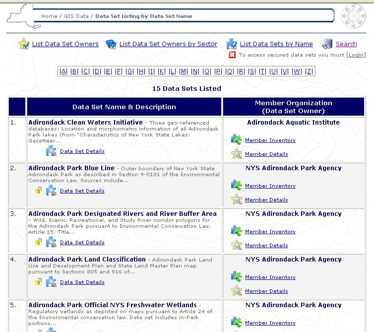
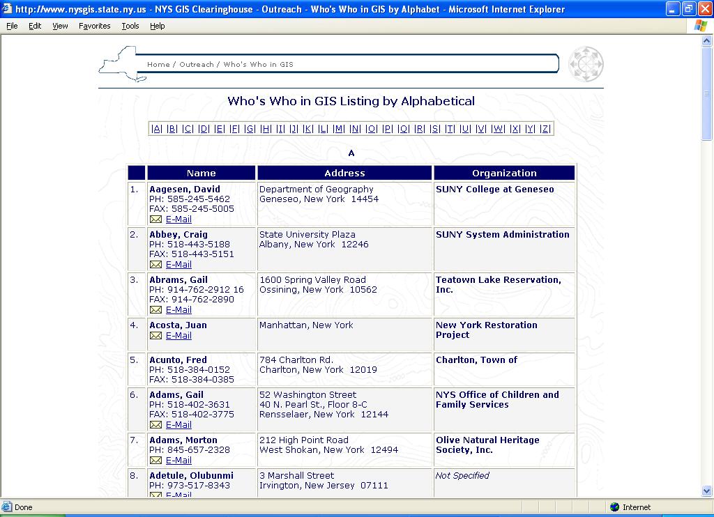
39 ACS Statistical Quality Impute missing data ACS products (sample) Reported at 90-percent confidence level Summary Files also have Standard Errors May affect uses of the data Denominators Regression analysis

40 The census does not always put populations in the correct census area. Merge these blocks before using aggregation tool From 2000 census 40


41 Census Enumeration Errors 831 persons living in Colonie Shopping Center 0 persons living in neighboring apartments

42 Intercensal Estimates are Unreliable example: several disease cases have recently occurred in this area, the intercensal Claritas estimate = 0 population New construction Census Persons 2008 Intercensal Estimate 0 persons 42

43 Temporal Accuracy TIGER Streets Real Property Points

44 Spatial Accuracy Census TIGER Files (2000)

45 New York ALIS Street Files (2005)
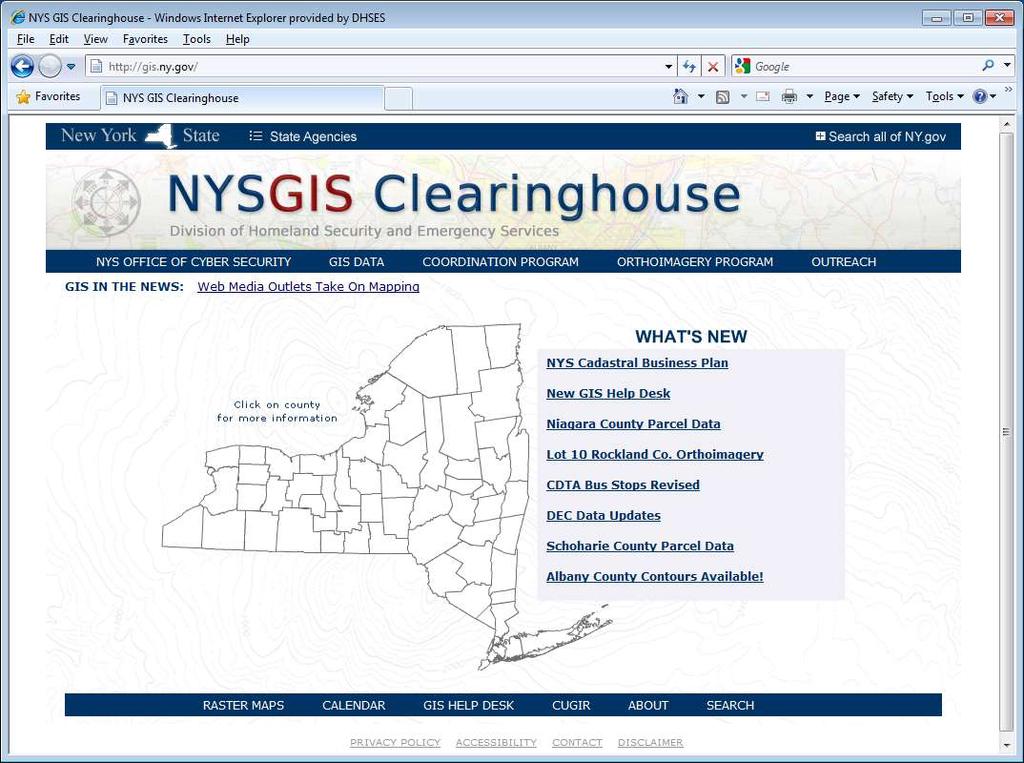
46 Data Sharing New York Stat Clearinghouse Model

47 Geographic Databases Framework Data Additional Base Data Land Ownership Transportation Surface Waters Boundaries Geodetic Control Elevation Ortho Imagery Flood Zones Wetlands Landcover Water Lines Sewer Lines Soils 47

48 NYS GIS Data Sharing Cooperative Government, NFP, Academics Contacts Feedback 48
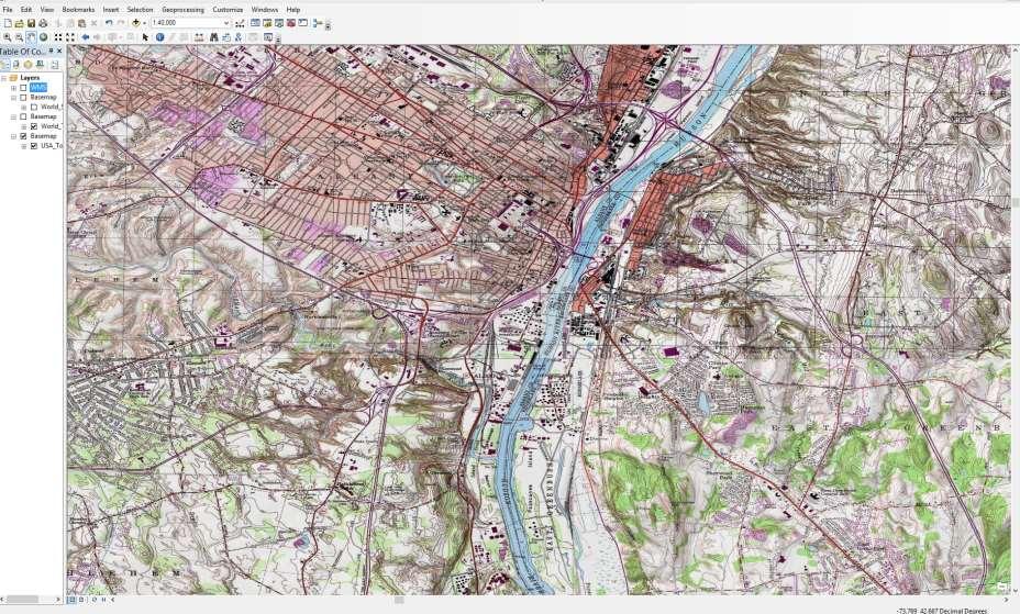
49
50
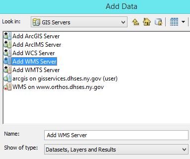
51
52
53
54 Orthoimagery Program 4-Bands (R, G, B, and N-IR) 1-ft GSD in urban areas, +/- 4-ft 2-ft GSD in rural areas, +/- 8-ft NYC Specs 0.5-ft Color, +/- 2-ft All structures in Manhattan orthorectified Structures above 5-stories in outer boroughs orthorectified June flight for Manhattan Ground Sampling Distance (GSD) - distance between pixel centers
55

56 ArcGIS Provides Access to a Number of On-line Base Maps Example : World Street Maps
57 USA Topographic Maps

58 Adding a Web Map Service (WMS) to your Map NYS GIS Clearinghouse Orthoimagery
59 Street Address Mapping(SAM) Create a statewide authoritative address point database to support next-generation and other purposes
 will support all lower requirements Not a re-addressing project;")
60 SAM Big Picture Next Generation 911 requires GIS data Huge range of needs for address data statewide Building to highest level requirements (i.e. 911) will support all lower requirements Not a re-addressing project; we re just mapping what you've got Address point data will Support dispatch Be publicly available for widespread uses Support high-quality geocoding Contain no personal or sensitive information Contain unique IDs

61 61 Apartment Building Complex 70 Mc Carty Ave Building 1, Apt 1; Building 2, Apt 4; etc.
62 Homework Read: Chapter 3: Cromley & McLafferty, GIS & Public Health Mills JW, Curtis A, et al. The clearinghouse concept: a model for geospatial data centralization and dissemination in a disaster. Disasters, (3): Explore: US Census Web site: New York State GIS Clearinghouse: http//gis.ny.gov The End
US Census. Thomas Talbot February 5, 2013
 US Census Thomas Talbot February 5, 2013 Outline Census Geography TIGER Files Decennial Census - Complete count American Community Survey Yearly Sample Obtaining Data - American Fact Finder - Census FTP
The 2010 Census: Count Question Resolution Program
 The 2010 Census: Count Question Resolution Program Jennifer D. Williams Specialist in American National Government December 7, 2012 CRS Report for Congress Prepared for Members and Committees of Congress
Quick Reference Guide
 U.S. Census Bureau Revised 07-28-13 Quick Reference Guide Demographic Program Comparisons Decennial Census o Topics Covered o Table Prefix Codes / Product Types o Race / Ethnicity Table ID Suffix Codes
Version 2.2 April Census Local Update of Census Addresses Operation (LUCA) Frequently Asked Questions
 Frequently Asked Questions") Version 2.2 April 2017 2020 Census Local Update of Census Addresses Operation (LUCA) Frequently Asked Questions [This page intentionally left blank] 2020 Census LUCA Frequently Asked Questions TABLE OF
Version 2.2 April 2017 2020 Census Local Update of Census Addresses Operation (LUCA) Frequently Asked Questions [This page intentionally left blank] 2020 Census LUCA Frequently Asked Questions TABLE OF
The 2020 Census Geographic Partnership Opportunities. Geography Division U.S. Census Bureau
 The 2020 Census Geographic Partnership Opportunities Geography Division U.S. Census Bureau Legal Legal entities originate from legal actions, treaties, statutes, ordinances, resolutions, court decisions,
Overview of Census Bureau Geographic Areas and Concepts
 Overview of Census Bureau Geographic Areas and Concepts Drew Stanislaw US Census Bureau WVAGP Annual Meeting Shepherdstown, WV June 13, 2011 1 What is the role of geography in the Census? The Census count
2020 CENSUS LOCAL UPDATE OF CENSUS ADDRESSES OPERATION (LUCA) U.S. Census Bureau Geography Division
 U.S. Census Bureau Geography Division") 2020 CENSUS LOCAL UPDATE OF CENSUS ADDRESSES OPERATION (LUCA) U.S. Census Bureau Geography Division 1 Agenda 2020 Census Local Update of Census Addresses Operation (LUCA) Participation in LUCA Why participate
2020 CENSUS LOCAL UPDATE OF CENSUS ADDRESSES OPERATION (LUCA) U.S. Census Bureau Geography Division 1 Agenda 2020 Census Local Update of Census Addresses Operation (LUCA) Participation in LUCA Why participate
Handout Packet. QuickFacts o Frequently Asked Questions
 Census Data Immersion Infopeople Webinar August 7, 2012 Handout Packet QuickFacts o Frequently Asked Questions Demographic Program Tips o 2010 Decennial Census o Population Estimates Program (PEP) o American
2020 Census Local Update of Census Addresses Operation (LUCA)
") 2020 Census Local Update of Census Addresses Operation (LUCA) The Decennial Census The purpose is to conduct a census of population and housing and disseminate results to the President, the States, and
2020 Census Local Update of Census Addresses Operation (LUCA) The Decennial Census The purpose is to conduct a census of population and housing and disseminate results to the President, the States, and
Claritas Demographic Update Methodology Summary
 Claritas Demographic Update Methodology Summary 2006 by Claritas Inc. All rights reserved. Warning! The enclosed material is the intellectual property of Claritas Inc. (Claritas is a subsidiary of VNU,
The American Community Survey and the 2010 Census
 Portland State University PDXScholar Publications, Reports and Presentations Population Research Center 3-2011 The American Community Survey and the 2010 Census Robert Lycan Portland State University Charles
Redistricting San Francisco: An Overview of Criteria, Data & Processes
 Redistricting San Francisco: An Overview of Criteria, Data & Processes Karin Mac Donald Q2 Data & Research, LLC October 5, 2011 1 Criteria in the San Francisco Charter: Districts must conform to all legal
Overview of Demographic Data
 Overview of Demographic Data Michael Ratcliffe Geography Division US Census Bureau Mapping Sciences Committee October 20, 2014 Sources of Demographic Data Censuses Full enumeration, or counting, of the
In-Office Address Canvassing for the 2020 Census: an Overview of Operations and Initial Findings
 In-Office Address Canvassing for the 2020 Census: an Overview of Operations and Initial Findings Michael Commons Address and Spatial Analysis Branch Geography Division U.S. Census Bureau In-Office Address
Realigning Historical Census Tract and County Boundaries
 Realigning Historical Census Tract and County Boundaries David Van Riper Research Fellow Minnesota Population Center University of Minnesota Twin Cities dvanriper@gmail.com Stanley Dallal ESEA dallal@esea.com
The U.S. Decennial Census A Brief History
 1 The U.S. Decennial Census A Brief History Under the direction of then Secretary of State, Thomas Jefferson, the first U.S. Census began on August 2, 1790, and was to be completed by April 1791 The total
Road to the 2020 Census October 13, :15 p.m. 5:15 p.m. WEBINAR Presentation for: South Dakota - State Data Center s 5 th Annual Demography
 Road to the 2020 Census October 13, 2017 4:15 p.m. 5:15 p.m. WEBINAR Presentation for: South Dakota - State Data Center s 5 th Annual Demography Conference Presenter: Blanca Ramirez-Salazar, Partnership
Working with United States Census Data. K. Mitchell, 7/23/2016 (no affiliation with U.S. Census Bureau)
") Working with United States Census Data K. Mitchell, 7/23/2016 (no affiliation with U.S. Census Bureau) Outline Types of Data Available Census Geographies & Timeframes Data Access on Census.gov website
Working with United States Census Data K. Mitchell, 7/23/2016 (no affiliation with U.S. Census Bureau) Outline Types of Data Available Census Geographies & Timeframes Data Access on Census.gov website
Census Records, City Directories, Maps
 This is a very high-level explanation of the complex topic, census records. An excellent source of detailed information can be found in The Source, A Guidebook of American Genealogy, Loretto Dennis Szucs,
Welcome to: A Tour of Data Sources from the U.S. Census Bureau. Monday, October 19, :00 am 12:00 noon CT
 Welcome to: A Tour of Data Sources from the U.S. Census Bureau Monday, October 19, 2015 11:00 am 12:00 noon CT 1 Illinois Early Childhood Asset Map (IECAM) http://iecam.illinois.edu University of Illinois
The 2020 Census Geographic Partnership Opportunities
 The 2020 Census Geographic Partnership Opportunities Web Adams Geographer, U.S. Census Bureau New York Regional Office 1 Geographic Partnership Opportunities The 2020 Census Local Update of Census Addresses
1980 Census 1. 1, 2, 3, 4 indicate different levels of racial/ethnic detail in the tables, and provide different tables.
 1980 Census 1 1. 1980 STF files (STF stands for Summary Tape File from the days of tapes) See the following WWW site for more information: http://www.icpsr.umich.edu/cgi/subject.prl?path=icpsr&query=ia1c
Dallas Regional Office US Census Bureau
 The Census Bureau: Important Data Products for Every Community Paula Wright, Information Services Specialist Suzee Privett, Information Services Assistant Willie DeBerry, Partnership Specialist Lacey Loftin,
2020 Census Local Update of Census Addresses. Operation (LUCA) Promotion
 Promotion") 2020 Census Local Update of Census Addresses Atlanta Regional Office Managing Census Operations in: AL, FL, GA, LA, MS, NC, SC Operation (LUCA) Promotion 2020 Census Overview What is LUCA? Agenda LUCA
2020 Census Local Update of Census Addresses Atlanta Regional Office Managing Census Operations in: AL, FL, GA, LA, MS, NC, SC Operation (LUCA) Promotion 2020 Census Overview What is LUCA? Agenda LUCA
The 2020 Census: Preparing for the Road Ahead
 The 2020 Census: Preparing for the Road Ahead Presentation to the National Association of Counties 2017 Annual Conference Columbus, OH July 23, 2017 The Decennial Census Purpose: To conduct a census of
Table 5 Population changes in Enfield, CT from 1950 to Population Estimate Total
 This chapter provides an analysis of current and projected populations within the Town of Enfield, Connecticut. A review of current population trends is invaluable to understanding how the community is
Taming the Census TIGER:
 Taming the Census TIGER: Download TIGER Files using American FactFinder Eric Coyle Data Dissemination Specialist U.S. Census Bureau Outline ACS Overview Census Geography Accessing TIGER/ACS Data Products
Statewide Orthoimagery 2010 Data Delivery (excerpts for imagery review)
") Statewide Orthoimagery 2010 Data Delivery (excerpts for imagery review) Center for Geographic Information and Analysis Tim Johnson, Director March 2011 Project In Brief City of Durham PSAP Funded by NC
Statewide Orthoimagery 2010 Data Delivery (excerpts for imagery review) Center for Geographic Information and Analysis Tim Johnson, Director March 2011 Project In Brief City of Durham PSAP Funded by NC
Using Location-Based Services to Improve Census and Demographic Statistical Data. Deirdre Dalpiaz Bishop May 17, 2012
 Using Location-Based Services to Improve Census and Demographic Statistical Data Deirdre Dalpiaz Bishop May 17, 2012 U.S. Census Bureau Mission To serve as the leading source of quality data about the
population and housing censuses in Viet Nam: experiences of 1999 census and main ideas for the next census Paper prepared for the 22 nd
 population and housing censuses in Viet Nam: experiences of 1999 census and main ideas for the next census Paper prepared for the 22 nd Population Census Conference Seattle, Washington, USA, 7 9 March
Notes on the 2014 ACS 5-Year Estimates
 Notes on the 2014 ACS 5-Year Estimates Eric Guthrie, Michigan s State Demographer December 3, 2015 The U.S. Census Bureau has released the 2014 American Community Survey (ACS) 5-year estimates. The 5-year
Claritas Update Demographics Methodology
 Claritas Update Demographics Methodology 2008 by Claritas Inc. All rights reserved. Warning! The enclosed material is the intellectual property of Claritas Inc. (Claritas is a subsidiary of The Nielsen
U.S. Census Bureau. Measuring America: People, Places, and Our Economy. Community Analysis Workshop. Armando Mendoza Data Dissemination Specialist
 U.S. Census Bureau Measuring America: People, Places, and Our Economy Community Analysis Workshop Armando Mendoza Data Dissemination Specialist U.S. Census Bureau September 21, 2017 Hello, I am Armando
A Special Case of integrating administrative data and collection data in the context of the 2016 Canadian Census
 A Special Case of integrating administrative data and collection data in the context of the 2016 Canadian Census Telling Canada s story in numbers Josée Morel Statistics Canada June 16 th, 2017 Agenda
Claritas Demographic Update Methodology
 Claritas Demographic Update Methodology 2006 by Claritas Inc. All rights reserved. Warning! The enclosed material is the intellectual property of Claritas Inc. (Claritas is a subsidiary of VNU, a global
The 2020 Census A New Design for the 21 st Century
 The 2020 Census A New Design for the 21 st Century The Decennial Census Purpose: To conduct a census of population and housing and disseminate the results to the President, the States, and the American
Geog 3340: Census Basics
 Geog 3340: Census Basics About the US Census Bureau Mandated by the U. S. Constitution to count the population Used: to apportion seats in the U.S. House of Representatives to define legislature districts,
Understanding and Using the U.S. Census Bureau s American Community Survey
 Understanding and Using the US Census Bureau s American Community Survey The American Community Survey (ACS) is a nationwide continuous survey that is designed to provide communities with reliable and
Finding U.S. Census Data with American FactFinder Tutorial
 Finding U.S. Census Data with American FactFinder Tutorial Mark E. Pfeifer, PhD Reference Librarian Bell Library Texas A and M University, Corpus Christi mark.pfeifer@tamucc.edu 361-825-3392 Population
Census Data for Grant Writing Workshop Cowlitz-Wahkiakum Council of Governments. Heidi Crawford Data Dissemination Specialist U.S.
 Census Data for Grant Writing Workshop Cowlitz-Wahkiakum Council of Governments Heidi Crawford Data Dissemination Specialist U.S. Census Bureau Agenda Welcome and Introductions Overview of Census Data
Town of Skowhegan Application For Development Review
 Town of Skowhegan Application For Development Review Return to: Skowhegan Planning Office 225 Water St., Skowhegan, ME 04976 (207) 474-6904 skowcodesec@skowhegan.org To be filled in by Staff: Project Name:
Improving the Quality of Geocoded Data
 Improving the Quality of Geocoded Data NCCCP & NPCR Conference April 15, 2009 Kevin C. Ward, PhD, CTR Georgia Center for Cancer Statistics Census Geography Geographic Unit State County Census Tract (average
The Canadian Century Research Infrastructure: locating and interpreting historical microdata
 The Canadian Century Research Infrastructure: locating and interpreting historical microdata DLI / ACCOLEDS Training 2008 Mount Royal College, Calgary December 3, 2008 Nicola Farnworth, CCRI Coordinator,
2020 Census Local Update of Census Addresses Operation (LUCA) U.S. Census Bureau Geography Division
 U.S. Census Bureau Geography Division") 2020 Census Local Update of Census Addresses Operation (LUCA) U.S. Census Bureau Geography Division 1 Agenda 2020 Census LUCA Operation Participation in LUCA What is LUCA? Who Can Participate? Why participate?
2020 Census Local Update of Census Addresses Operation (LUCA) U.S. Census Bureau Geography Division 1 Agenda 2020 Census LUCA Operation Participation in LUCA What is LUCA? Who Can Participate? Why participate?
Using Data to Improve Health Services. A workshop for Community Supported Clinics
 Using Data to Improve Health Services A workshop for Community Supported Clinics Charles Rynerson Sheila Martin April 10, 2017 Why can data help you serve your community? Workshop Agenda Important sources
Census 2010 Participation Rates, Results for Alaska, and Plans for the 2020 Census
 Census 2010 Participation Rates, Results for Alaska, and Plans for the 2020 Census Evan Moffett, Assistant Division Chief Geographic Operations Decennial Census Management Division U.S. Census Bureau 2016
Local Update of Census Addresses Program Promotional Workshop
 Local Update of Census Addresses Program Promotional Workshop Will Your Community Be Ready? US Census Bureau Chicago Regional Office Stanley D. Moore, Regional Director 1 Welcome to the Local Update of
Census Data Determines Who Gets $300 Billion Annually Are You Getting Your Share?
 Census Data Determines Who Gets $300 Billion Annually Are You Getting Your Share? Hartford Foundation for Public Giving November 13, 2009 Jim Palma, Partnership Specialist Hartford Local Census Office
Catalogue no X. Geography Catalogue. Census year 2011
 Catalogue no. 92-196-X Geography Catalogue Census year 2011 How to obtain more information For information about this product or the wide range of services and data available from Statistics Canada, visit
ALASKA NATIVE MORTALITY UPDATE:
 INTRODUCTION Reliable information on cause of death is essential to the development of policies and programs for prevention and control of disease and injury. This report provides information about the
Understanding the Census A Hands-On Training Workshop
 Understanding the Census A Hands-On Training Workshop Vanderbilt Census Information Center March 23, 2003 U.S. Census Bureau The world s largest and most comprehensive data collection and analysis organization!!!
Methodologies and IT-tools for managing and monitoring field work using geo-spatial tools and other IT- Tools for monitoring
 Methodologies and IT-tools for managing and monitoring field work using geo-spatial tools and other IT- Tools for monitoring Janusz Dygaszewicz Central Statistical Office of Poland Jerusalem, 11-14 July
ESP 171 Urban and Regional Planning. Demographic Report. Due Tuesday, 5/10 at noon
 ESP 171 Urban and Regional Planning Demographic Report Due Tuesday, 5/10 at noon Purpose The starting point for planning is an assessment of current conditions the answer to the question where are we now.
Census Blocks and Block Groups
 Census Blocks and Block Groups Chapter 11 Census blocks, the smallest geographic area for which the Bureau of the Census collects and tabulates decennial census data, are formed by streets, roads, railroads,
Guidance for Calculating Incidence by Census Tract Poverty Level Using 2010 Census and ACS
 Guidance for Calculating Incidence by Census Tract Poverty Level Using 2010 Census and 2006-2010 ACS Prepared for CSTE Disparities Workgroup by Karman Tam, MPH candidate and Kimberly Yousey-Hindes, MPH,
1 NOTE: This paper reports the results of research and analysis
 Race and Hispanic Origin Data: A Comparison of Results From the Census 2000 Supplementary Survey and Census 2000 Claudette E. Bennett and Deborah H. Griffin, U. S. Census Bureau Claudette E. Bennett, U.S.
American Community Survey Review and Tips for American Fact Finder. Sarah Ehresman Kentucky State Data Center August 7, 2014
 1 American Community Survey Review and Tips for American Fact Finder Sarah Ehresman Kentucky State Data Center August 7, 2014 2 American Community Survey An ongoing annual survey that produces characteristics
The Road to 2020 Census
 The Road to 2020 Census Wednesday, May 17 th, 2017 9:00 am-12n North Central Texas Council of Governments 616 Six Flags Drive, Arlington, TX Arlington, TX 1 AGENDA OVERVIEW Decennial Census Basics, 2010
My Tribal Area: Census Data Overview & Access. Eric Coyle Data Dissemination Specialist U.S. Census Bureau
 My Tribal Area: Census Data Overview & Access Eric Coyle Data Dissemination Specialist U.S. Census Bureau AGENDA Overview of Census Bureau Programs and Datasets available Census Geographies Ways to Access
Strategies for the 2010 Population Census of Japan
 The 12th East Asian Statistical Conference (13-15 November) Topic: Population Census and Household Surveys Strategies for the 2010 Population Census of Japan Masato CHINO Director Population Census Division
BETWEEN APRIL 1 AND JUNE 30, 2013, LAC LA BICHE COUNTY UNDERTOOK A MUNICIPAL CENSUS TO DETERMINE THE COUNTY S POPULATION AND
 2013 CENSUS SUMMARY BETWEEN APRIL 1 AND JUNE 30, 2013, LAC LA BICHE COUNTY UNDERTOOK A MUNICIPAL CENSUS TO DETERMINE THE COUNTY S POPULATION AND DEMOGRAPHICS. THE COUNTY S CENSUS DATE WAS MAY 15, 2013.
Presented by Doris Ma Fat on behalf of the. Department of Health Statistics and Information Systems World Health Organization, Geneva
 Causes of death certification Presented by Doris Ma Fat (mafatd@who.int) on behalf of the Department of World Health Organization, Geneva at United Nations Sub-regional workshop on applying Principles
Learning to Use the ACS for Transportation Planning Report on NCHRP Project 8-48
 Learning to Use the ACS for Transportation Planning Report on NCHRP Project 8-48 presented to TRB Census Data for Transportation Planning Meeting presented by Kevin Tierney Cambridge Systematics, Inc.
American Community Survey Overview
 American Community Survey Overview ACS Data Users Conference May 11, 2015 Gretchen Gooding American Community Survey Office 1 Outline American Community Survey (ACS) basics Resources for learning more
Memorandum City of Lawrence Planning and Development Services
 Memorandum City of Lawrence Planning and Development Services TO: FROM: CC: David L. Corliss, City Manager Amy Miller, Long-Range Planner David Guntert, GIS Planner Scott McCullough, Planning & Development
The 2020 Census: A New Design for the 21 st Century Deirdre Dalpiaz Bishop Chief Decennial Census Management Division U.S.
 The 2020 Census: A New Design for the 21 st Century Deirdre Dalpiaz Bishop Chief Decennial Census Management Division U.S. Census Bureau National Conference of State Legislatures Fall Forum December 9,
Making Sense of Census Data Robert Matthews, University of Alabama at Birmingham, Birmingham, Alabama
 Paper MPSF 074 Making Sense of Census Data Robert Matthews, University of Alabama at Birmingham, Birmingham, Alabama ABSTRACT The United States Census Bureau publishes a vast amount of data on many different
2020 Census. Bob Colosi Decennial Statistical Studies Division February, 2016
 2020 Census Bob Colosi Decennial Statistical Studies Division February, 2016 Decennial Census Overview (1 of 2) Purpose: To conduct a census of population and housing and disseminate the results to the
USING CENSUS RECORDS IN GENEALOGICAL RESEARCH AN ONLINE COURSE
 IN GENEALOGICAL RESEARCH AN ONLINE COURSE Syllabus An NGS Online Course IN GENEALOGICAL RESEARCH SYLLABUS Copyright 2009 National Genealogical Society 3108 Columbia Pike, Suite 300 Arlington, Virginia
Salvo 10/23/2015 CNSTAT 2020 Seminar (revised ) (SLIDE 2) Introduction My goal is to examine some of the points on non response follow up
 (SLIDE 2) Introduction My goal is to examine some of the points on non response follow up") Salvo 10/23/2015 CNSTAT 2020 Seminar (revised 10 28 2015) (SLIDE 2) Introduction My goal is to examine some of the points on non response follow up (NRFU) that you just heard, through the lens of experience
Salvo 10/23/2015 CNSTAT 2020 Seminar (revised 10 28 2015) (SLIDE 2) Introduction My goal is to examine some of the points on non response follow up (NRFU) that you just heard, through the lens of experience
The Census Bureau s Master Address File (MAF) Census 2000 Address List Basics
 Census 2000 Address List Basics") The Census Bureau s Master Address File (MAF) Census 2000 Address List Basics OVERVIEW The Census Bureau is developing a nationwide address list, often called the Master Address File (MAF) or the Census
The Census Bureau s Master Address File (MAF) Census 2000 Address List Basics OVERVIEW The Census Bureau is developing a nationwide address list, often called the Master Address File (MAF) or the Census
2010 Census Mapping Evolution, Potentialities and Integration to the National Spatial Data Infrastructure
 2010 Census Mapping Evolution, Potentialities and Integration to the National Spatial Data Infrastructure Miriam Barbuda, MsC LATIN AMERICA GEOSPATIAL FORUM Brazil, Rio de Janeiro, 15-17August 2012 BRAZIL
Benefits of Sample long Form to Enlarge the scope of Census Data Analysis: The Experience Of Bangladesh
 yed S. Hossain, University of Dhaka A K M Mahabubur Rahman Joarder, Statistics Division, GOB Md. Abdur Rahim, BBS, GOB eeds Assessment Conference On Census Analysis III Benefits of Sample long Form to
2020 CENSUS LOCAL UPDATE OF CENSUS ADDRESSES (LUCA) OPERATION. Frequently Asked Questions (FAQs)
 OPERATION. Frequently Asked Questions (FAQs)") 2020 CENSUS LOCAL UPDATE OF CENSUS ADDRESSES (LUCA) OPERATION Frequently Asked Questions (FAQs) [This page intentionally left blank] Table of Contents Advance Notice... 1 1. What is the 2020 LUCA advance
2020 CENSUS LOCAL UPDATE OF CENSUS ADDRESSES (LUCA) OPERATION Frequently Asked Questions (FAQs) [This page intentionally left blank] Table of Contents Advance Notice... 1 1. What is the 2020 LUCA advance
The American Community Survey Motivation, History, and Design. Workshop on the American Community Survey Havana, Cuba November 16, 2010
 The American Community Survey Motivation, History, and Design Workshop on the American Community Survey Havana, Cuba November 16, 2010 1 Outline What is the ACS? Motivation and design goals Key ACS historical
Documentation for April 1, 2010 Bridged-Race Population Estimates for Calculating Vital Rates
 Documentation for April 1, 2010 Bridged-Race Population Estimates for Calculating Vital Rates The bridged-race April 1, 2010 population file contains estimates of the resident population of the United
National Longitudinal Study of Adolescent Health. Public Use Contextual Database. Waves I and II. John O.G. Billy Audra T. Wenzlow William R.
 National Longitudinal Study of Adolescent Health Public Use Contextual Database Waves I and II John O.G. Billy Audra T. Wenzlow William R. Grady Carolina Population Center University of North Carolina
A GI Science Perspective on Geocoding:
 A GI Science Perspective on Geocoding: Accuracy, Repeatability and Implications for Geospatial Privacy Paul A Zandbergen Department of Geography University of New Mexico Geocoding as an Example of Applied
National Census Geography Some lessons learned and future challenges in European countries
 UNSD-AITRS Regional Workshop on the Integration of Statistical and Geospatial Information Amman, Jordan, 16-20 February, 2015 National Census Geography Some lessons learned and future challenges in European
U.S. Synthetic Population 2010 Version 1.0
 RTI Project Number 0212177.005.002 U.S. Synthetic Population 2010 Version 1.0 Quick Start Guide May, 2014 Prepared by RTI International 3040 Cornwallis Road Research Triangle Park, NC 27709 This work was
Geocoding and Address Matching
 LAB PREP: Geocoding and Address Matching Environmental, Earth, & Ocean Science 381 -Spring 2015 - Geocoding The process by which spatial locations are determined using coordinate locations specified in
Who s in Your Neighborhood? Using the American FactFinder. Salma Abadin and Carrie Koss Vallejo Data You Can Use
 Who s in Your Neighborhood? Using the American FactFinder Salma Abadin and Carrie Koss Vallejo Data You Can Use www.datayoucanuse.org Learning Objectives Learn what American FactFinder is and is not Become
Catalogue no G ISBN Reference Maps and Thematic Maps, Reference Guide. Census year Release date: November 16, 2016
 Catalogue no. 92-143-G ISBN 978-0-660-06710-0 Reference Maps and Thematic Maps, Reference Guide Release date: November 16, 2016 How to obtain more information For information about this product or the
CENSUS DATA COLLECTION IN MALTA
 CENSUS DATA COLLECTION IN MALTA 30 November 2016 Dorothy Gauci Head of Unit Population and Migration Statistics Overview Background Methodology Focus on migration Conclusion Pop at end 2015: 434,403 %
Environmental Justice Tool Guide
 Environmental Justice Tool Guide This document is intended to accompany the Environmental Justice section of MnDOT s Highway Project Development Process. This document provides additional guidance to steps
HEALTH STATUS. Health Status
 HEALTH STATUS HEALTH STATUS This chapter on health status provides data about Haldimand County and Norfolk County s health status considered by mortality, unintentional injuries and obesity. Data on mortality
Census TIGER US Department of Commerce Economics and Statistics Administration BUREAU OF THE CENSUS
 TIGER/Line Files, 1995 Technical Documentation Census TIGER US Department of Commerce Economics and Statistics Administration BUREAU OF THE CENSUS Acknowledgments The TIGER/Line Files, 1995 Technical Documentation
Twenty Year Forecasts of Population and Households, Louisville Economic Area
 Twenty Year Forecasts of Population and Households, Louisville Economic Area Economic Geography The U.S. Bureau of Economic Analysis (BEA) assigns every county in the nation to an economic area. BEA s
Lecture 8 Geocoding. Dr. Zhang Spring, 2017
 Lecture 8 Geocoding Dr. Zhang Spring, 2017 Model of the course Using and making maps Navigating GIS maps Map design Working with spatial data Geoprocessing Spatial data infrastructure Digitizing File geodatabases
Geocoding Address Data & Using Geocoded Data
 Geocoding Address Data & Using Geocoded Data This document located at /geocoding.pdf Using this Document & Terms of Use Copyright 2014. ProximityOne. All Rights Reserved. Geocoding Address Data Terms of
The progress in the use of registers and administrative records. Submitted by the Department of Statistics of the Republic of Lithuania
 Working Paper No. 24 ENGLISH ONLY STATISTICAL COMMISSION and ECONOMIC COMMISSION FOR EUROPE STATISTICAL OFFICE OF THE EUROPEAN COMMUNITIES (EUROSTAT) CONFERENCE OF EUROPEAN STATISTICIANS Joint ECE/Eurostat
An Overview of the American Community Survey
 An Overview of the American Community Survey Scott Boggess U.S. Census Bureau 2009 National Conference for Adult Education State Directors Washington, DC March 17, 2009 1 Overview What is the American
The 2020 Census Geographic Partnership Opportunities
 The 2020 Census Geographic Partnership Opportunities Brian Timko Branch Chief Address Data Collection and Products Branch Geography Division U.S. Census Bureau 1 Geographic Partnership Opportunities The
Reengineering the 2020 Census
 Reengineering the 2020 Census John Thompson Director U.S. Census Bureau Lisa M. Blumerman Associate Director Decennial Census Programs U.S. Census Bureau Presentation to the Committee on National Statistics
COUNTRY REPORT: TURKEY
 COUNTRY REPORT: TURKEY (a) Why Economic Census? - Under what circumstances the Economic Census is conducted in your country. Why the economic census is necessary? - What are the goals, scope and coverage
Modernizing Disclosure Avoidance: Report on the 2020 Disclosure Avoidance Subsystem as Implemented for the 2018 End-to-End Test (Continued)
") Modernizing Disclosure Avoidance: Report on the 2020 Disclosure Avoidance Subsystem as Implemented for the 2018 End-to-End Test (Continued) Simson L. Garfinkel Chief, Center for Disclosure Avoidance Research
Modernizing Disclosure Avoidance: Report on the 2020 Disclosure Avoidance Subsystem as Implemented for the 2018 End-to-End Test (Continued) Simson L. Garfinkel Chief, Center for Disclosure Avoidance Research
County Profiles Introduction. Introduction 1/17/2013. A compendium of Demographic, Housing, Education, Economic, and Agricultural Data
 County Profiles 2013 A compendium of Demographic, Housing, Education, Economic, and Agricultural Data Jan K. Vink and Joe D. Francis Nij Tontisirin, Sutee Anantsuksomsri and Johannes Plambeck Introduction
2010 Census TIGER/Line Shapefiles
 R 2010 Census TIGER/Line Shapefiles Technical Documentation 2010 U.S. Department of Commerce Geography Division U.S. Census Bureau Acknowledgments 2010 Census TIGER/Line Shapefiles Technical Documentation
The ONS Longitudinal Study
 Geography and Geographical Analysis using the ONS Longitudinal Study Christopher Marshall & Julian Buxton CeLSIUS Aims of the Presentation What is the ONS LS and what data does it contain? What geographical
Census Geography Items in the Homer Babbidge Collection
 University of Connecticut DigitalCommons@UConn UCCGIA University of Connecticut Center for Geographic Information and Analysis and MAGIC February 2008 Census Geography Items in the Homer Babbidge Collection