In-Office Address Canvassing for the 2020 Census: an Overview of Operations and Initial Findings
|
|
|
- Marjorie Park
- 5 years ago
- Views:
Transcription
1 In-Office Address Canvassing for the 2020 Census: an Overview of Operations and Initial Findings Michael Commons Address and Spatial Analysis Branch Geography Division U.S. Census Bureau
2 In-Office Address Canvassing for the 2020 Census: an Overview of Operations and Initial Findings Overview of 2020 Census Operations Ongoing Maintenance and Updates Address Canvassing Reengineered Canvassing Research and Development Status Update LUCA Preliminary Results of Changes in the Built Landscape
3 Decennial Census The purpose is to conduct a census of population and housing and disseminate results to the President, the States and the American People Uses of Census data: Apportioning representation among states as mandated by Article 1, Section 2 of the US Constitution Drawing congressional and state legislative districts, school districts and voting precincts Enforcing voting rights and civil rights legislation Distributing federal dollars Informing planning decisions of tribal, federal, state and local government and organizational decisions (e.g., where to locate, size of market, etc.) of businesses and non-profits
4
5 Maintaining an Accurate Address List On-going Maintenance and Update US Postal Service s Delivery Sequence File (DSF) Tribal, state, and local government address lists Continuous identification of stability and change Address Canvassing Nationwide In-Office Address Canvassing Annual In-field data collection, checks, and tests In-Field Address Canvassing LUCA Opportunity for review and update the Census Bureau s address list for the 2020 Census
6 Datasets Used in Updating, Maintaining, and Evaluating the Master Address File (MAF) US Postal Service Delivery Sequence File (DSF) and related products Locatable Address Conversion Service (LACS) file Enhanced Line of Travel (elot) Tribal, state, and local government address lists and parcel (cadastre) files Provided through Geographic Support System partnership activities Accessed on-line for in-office update programs Provided through the Local Update of Census Addresses (LUCA) program Building permits data (change detection; MAF analysis) Commercial address lists On-going Maintenance and Update Address Canvassing LUCA
7 Delivery Sequence File Records Added or Matched to the MAF, Year Number of DSF Residential Addresses Residential Addresses that are New to the DSF New DSF Residential Addresses Matched to the MAF New DSF Residential Addresses Added to the MAF Number Percent Number Percent ,674, , , , ,228,148 1,681, , , ,109, , , , ,093,231 1,074, , , ,165, ,957 87, , ,319, , , , ,591, , , , ,209, , , , Total ,819,547 2,165, ,653, On-going Maintenance and Update Address Canvassing LUCA
8 Address Improvements from Tribal, State, and Local Government Address Lists, Address Improvement Number of Addresses Addresses received 104,363,558 Addresses accepted for use in updating the MAF 83,312,316 Addresses updating information for existing addresses in MAF 82,976,258 New addresses added to the MAF 336,058 Addresses for which partner files provided new or improved latitude/longitude coordinates 65,095,658 MAF addresses for which geocodes were corrected by partner data 1,434,342 Previously un-geocoded MAF addresses geocoded using partner data 1,245,832 On-going Maintenance and Update Address Canvassing LUCA
9 Commercial Address Lists Matched to the MAF, 2016 Vendor Usable Addresses Number of Usable Addresses Matched to MAF Addresses Percentage of Usable Addresses Matched to MAF Addresses Number of Usable Addresses Matching DSF Addresses Percent of Usable Addresses Matching to DSFconfirmed Addresses 1 120,270, ,529, ,628, ,313,410 95,822, ,407, ,581, ,730, ,071, ,037,776 90,919, ,894, ,040, ,148, ,483, On-going Maintenance and Update Address Canvassing LUCA
10 2010 Census Address Canvassing Setting the Stage for Reengineered Address Canvassing Covered the entirety of the U.S. and Puerto Rico Exceptions: Remote Alaska and northern Maine, which account for nearly 12 percent of the US land area, but less than 1 percent of housing units Created a critical baseline set of information In 2009, more than 150,000 field staff drove every mile of road in the nation Verified and updated over 155 million address records Collected GPS points for all housing units visited Added more than 2.5 million new roads segments One of the most expensive decennial census field operations Two-thirds of the updates were concentrated in 4 percent of the blocks canvassed Cost over $450 million On-going Maintenance and Update Address Canvassing LUCA
11 Reengineered Address Canvassing General Questions: Is a traditional, on-the-ground canvassing operation necessary nationwide to ensure a complete and accurate address list for the decennial census? Are there areas of the country in which the address list and locational information can be kept current without canvassing in the field? Goals: Manage 70 percent or more of the addresses in the office; up to 30 percent of addresses canvassed in the field. What is 30 percent? Approximately 42.1 million addresses. To put into context: the 85 U.S. places with 100,000 or more population in 2015 contain a total of 24.7 million housing units (source: ACS year data). On-going Maintenance and Update Address Canvassing LUCA
12 What is Address Canvassing? Address canvassing is the process by which the U.S. Census Bureau validates, corrects, or deletes existing Census Bureau addresses, adds missing addresses before a decennial census MAF = Master Address File Blocks = Census tabulation blocks
13 Post-2010 Assessments: More efficient and cost effective ways to validate and update the MAF Many blocks are stable and the address list is correct and complete Address Canvassing Adds Were Very Concentrated Two-thirds of addresses added were located in just 4% of blocks

14
15 Post-2010 Assessments: More efficient and cost effective ways to validate and update the MAF Continuous MAF evaluation and update can be done throughout the decade: Continue USPS Delivery Sequence File (DSF) updates Partner with local governments obtain their address lists to validate and update the MAF (when needed) Re-engineer address canvassing so that areas can be canvassed in office, and only some areas need to be sent to field canvassing
16 Re-engineered Address Canvassing for the 2020 Census Address Canvassing In-Office In-Field Automated Interactive MAF/TIGER Update
17 In-Office Address Canvassing Goals Identify geographic areas that require in-field address canvassing and geographic areas that do not need to be canvassed in the field (i.e., in-office validation and improvement, where needed). Focus effort on decreasing in-field canvassing by identifying areas of stability. Where possible fix coverage issues and errors in the office. Identify, obtain, and manage data needed to support this activity and related review and decision-making efforts through the decade.
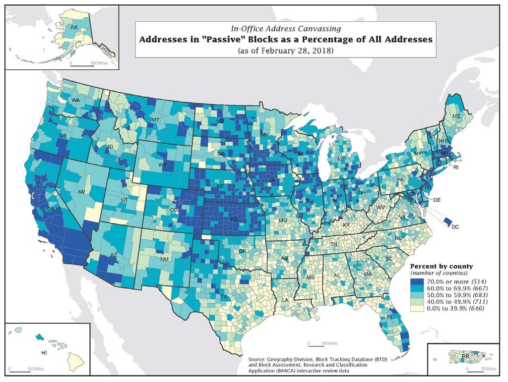
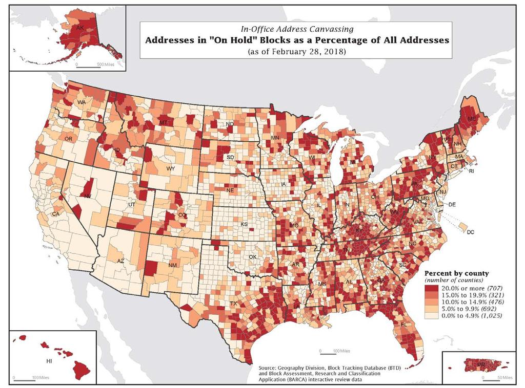
18 How do we achieve these goals? How do we know the MAF is correct and complete and that it continues to be correct and complete over time? Comparing the MAF to imagery, and assessing the propensity for change within the block. Interactive Review Data analysis and processes that determine where change is occurring/likely to occur and where is there stability in the MAF and in the residential landscape Triggers How do we fix address list issues in the office? Reviewing addresses where potential issue identified (above) and correcting the issue using local data sources Active Block Resolution
19 Address Canvassing for the 2020 Census In Office Address Canvassing Triggers Interactive Review (IR) Passive Active On Hold Triggers Active Block Resolution (ABR) Resolved Unresolved On Hold Triggers In-Field Address Canvassing Triggers
20 Interactive Review R & D How do we validate the address list is current and correct? Primarily through observation: Field observation comparing what is seen on the ground to the address list Office observation comparing imagery and street-level images to what is seen in the address list
21 Interactive Review R&D Pilot Project Spring ,924 blocks (0.2% nationally) were reviewed 11,286 reviewed twice to compare results between individual reviewers Review occurred in 29 counties selected for several characteristics, including: Partner file updates occurring MAF housing unit change Population Estimates Program housing unit change MAF Model Validation Test (MMVT) blocks Special land uses Urban/rural
22
23 Interactive Review R&D Pilot Project Spring 2014 Compare current imagery with 2009 vintage of imagery to identify change Assess imagery (and parcels, if available) for likelihood of stability or future change Assess current imagery and compare to current address information to identify coverage as well as geocoding issues Identify obvious errors in our data


24 Step 1: Identify Change Positive Change

25 Step 2: Built Out Residential B

26 Use parcel data to help identify HU count changes & built out Example of Built Out block containing large lots. HU count is 15, which matches number of houses in current imagery.
27 Use parcel data to help identify HU count changes & built out The same block as seen at the Kent County, DE GIS site

28 Step 2: Future Growth F
29 Step 3: Identify Coverage Issues Suspected Geocoding Problems

30 Stability: Built Out Blocks 69% of reviewed blocks were classified by the reviewers as built out Assuming the same pattern applied to all blocks nationally this would be roughly 7,697,000 blocks
31 Blocks with general data errors 8.2% of reviewed blocks had general data errors where the MAF counts didn t match what was on the ground. In this example, the MAF reported 12 housing units for the highlighted block. The block contains 12 multi-unit buildings. Skewed toward easy to observe errors, and blocks with few housing units (often small blocks).
")
 Requires In-Field")
32 In-Office Address Canvassing Overview In-Office Address Canvassing Interactive Review No Change or Coverage Issues Detected ( Passive ) Trigger Additional Interactive Review In-Field Address Canvassing On Hold Growth, Decline, or Coverage Issues ( Active ) Requires In-Field Resolution
 Note: This slide does not contain Title 13")
33 Block Assessment Review and Classification Application (BARCA ) Note: This slide does not contain Title 13 data.
 GEOID: 123456789101112 Note: This slide does not contain Title 13")
34 Baseline Imagery (circa 2009/2010) MAF Count: 4 (Without MSP= 0, With MSP = 4) GEOID: Note: This slide does not contain Title 13 data.
 GEOID: 123456789101112 Note: This slide does not contain Title 13")
35 Current Imagery (as of time of review) MAF Count: 4 (Without MSP= 4, With MSP = 0) GEOID: Note: This slide does not contain Title 13 data.


36 Interactive Review: Block Status Built-Out Open Space Note: This slide does not contain Title 13 data.
37 Triggers: Bringing Blocks Back into Interactive Review A trigger is an event that provides information and/or data that suggest the need to send a block back through IR. Examples include: New, or better resolution, imagery becomes available Results from processing DSF or GSS partner files Results from Ungeocoded Resolution and other MAF update and clean-up activities Automated imagery review/analysis that detects, or suggests, the existence of new housing A natural disaster (hurricane, flood, tornado) affects housing stock in an area to the extent that inhabitability, deliverability of mail, and existence of structures may be affected
38 Reviewed: December 2016 MAF Count: 6 (Without MSP= 0, With MSP = 6) GEOID: MAF Count Changed: June 2017 MAF Count: 7 (Without MSP= 0, With MSP = 7) GEOID: Note: This slide does not contain Title 13 data.
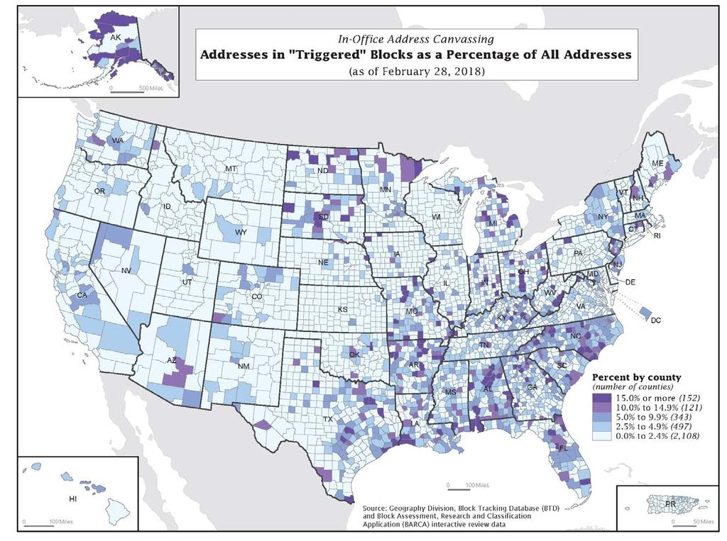
39 In-Office Address Canvassing Interactive Review Status: All Blocks (as of April 9, 2018) Blocks Housing Units Number Percentage Number Percentage Total US and Puerto Rico 11,155, ,700, Total Passive 8,781, ,871, Total Active 1,681, ,179, Total On-Hold 590, ,129, Total Triggered 101, ,520,
40 In-Office Address Canvassing Interactive Review Status: Mail-out/Mail-back Blocks (as of April 9, 2018) Blocks Housing Units Number Percentage Number Percentage Total US and Puerto Rico 9,827, ,052, Total Passive 7,774, ,875, Total Active 1,485, ,894, Total On-Hold 477, ,830, Total Triggered 90, ,451,
41
42
43
44

45 LUCA On-going Maintenance and Update Address Canvassing LUCA
46 Summary Building and maintaining the address list for the 2020 Census relies upon multiple administrative sources of addresses and multiple methods for reviewing, updating, and validating the MAF On-going maintenance and updates from multiple sources, anchored by the USPS Delivery Sequence File and local government address lists In-Office imagery-based Interactive Review to detect areas of stability and areas of change In-office resolution processes to resolve and update as many addresses as possible in the office prior to identifying areas to canvass in the field in 2019 Local Update of Census Addresses to provide tribal, state, and local governments the opportunity to review the Census Bureau s address list and provide updates On-going Maintenance and Update Address Canvassing LUCA
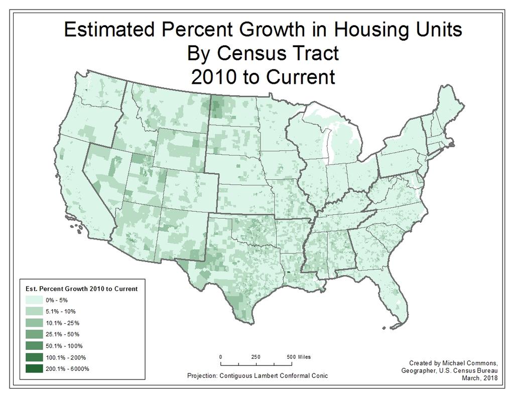
47 Changes in the Built Landscape Purpose of research Review of changes from 2000 to 2010 Data sources and methodology Results by geographic location and urban-rural type Comparison with demographic data Findings
48 Purpose of Research Summarize IR detection of change and compare to Housing Unit Estimates (HUE) Increase efficacy of ongoing in-office canvassing operations (2020 and beyond) Target specific areas of change More frequent in-office canvassing Pursue and acquire local data sources Avoid redundancy in areas with high likelihood of stability
49 Proportion of the Growth in Housing Units Census Divison 2000 to 2010 Middle Atlantic 6.3% East South Central 5.5% East North Central 10.3% Mountain 12.7% New England 3.0% Pacific (not AK, HI) 13.5% South Atlantic 28.7% West North Central 5.7% West South Central 14.2%
50 Data Sources Interactive Review (IR) Staff compare 2010 imagery to the most current imagery In addition to verifying the housing counts are correct, they also note changes in the landscape, including the removal or addition of housing units
 = 1 HU Medium (2) = 2-9 HU Large (3) = 10+")
51 Data Sources Interactive Review (IR) Staff compare 2010 imagery to the most current imagery In addition to verifying the housing counts are correct, they also note changes in the landscape, including the removal or addition of housing units Use a 3-class pin system Small (1) = 1 HU Medium (2) = 2-9 HU Large (3) = 10+ HU
52 Data Sources Housing Unit Change New addresses added since 2010 US Postal Service Delivery Sequence File (DFS) Geographic Support System (GSS) Housing Unit Estimates (Population Estimates Program) Demographic Data Demographic data extracted from American Community Survey 3- year ( )
 Housing Unit Estimates (Population Estimates Program).")
.")
53 Data Sources Housing Unit Change New addresses added since 2010 US Postal Service Delivery Sequence File (DFS) Geographic Support System (GSS) Housing Unit Estimates (Population Estimates Program). NOTE: Alaska, Hawaii, Puerto Rico, Demographic Data and Island Areas were removed Demographic data extracted from American Community Survey 3- year ( ). from the analysis because of significant differences in development patterns and urban classifications.
54 Methodology Data Analysis at multiple scales and geographies Census tract Census division 2010 Rural-Urban Commuting Area Codes (RUCA) Ten classes Created by USDA using Census urban areas Based on population density and functional connections (commuter patterns)
55 Methodology 2010 Rural-Urban Commuting Area Codes (RUCA) 1 Metropolitan area core: primary flow within an Urbanized Area (UA) 2 Metropolitan area high commuting: primary flow 30% or more to a UA 3 Metropolitan area low commuting: primary flow 10% to 30% to a UA 4 Micropolitan area core: primary flow within an Urban Cluster of 10,000 to 49,999 (large UC) 5 Micropolitan high commuting: primary flow 30% or more to a large UC 6 Micropolitan low commuting: primary flow 10% to 30% to a large UC 7 Small town core: primary flow within an Urban Cluster of 2,500 to 9,999 (small UC) 8 Small town high commuting: primary flow 30% or more to a small UC 9 Small town low commuting: primary flow 10% to 30% to a small UC 10 Rural areas: primary flow to a tract outside a UA or UC
56 Methodology IR Growth and Decline Pins multiplied by number of housing units expected Expected housing unit numbers based on analysis of Active Block Resolution (ABR) results Small (1) * 1 Medium (2) * 5.5 Large (3) * 15
57 Methodology IR Growth and Decline Pins multiplied by number of housing units expected Expected housing unit numbers based on analysis of Active Block Resolution (ABR) results Small (1) * 1 Medium (2) * 5.5 Large (3) * 15 Summed to the Census Tract New addresses can supplement IR Pins
58 Proportion of the Growth in Housing Units Census Divison 2000 to to Current Middle Atlantic 6.3% 5.5% East South Central 5.5% 8.7% East North Central 10.3% 7.1% Mountain 12.7% 14.5% New England 3.0% 3.4% Pacific (not AK, HI) 13.5% 10.0% South Atlantic 28.7% 22.6% West North Central 5.7% 8.5% West South Central 14.2% 19.7% Tracts with Growth and Decline 2010 to Current by Census Division All Tracts Growth Tracts Pct Tracts with Pct Tracts with Decline Tracts Growth Decline Middle Atlantic 10,147 6,214 4, % 48.1% East South Central 4,457 3,942 3, % 83.8% East North Central 11,808 8,286 8, % 70.3% Mountain 5,250 4,082 2, % 56.3% New England 3,392 2,733 2, % 60.6% Pacific (not AK, HI) 10,349 6,152 4, % 42.7% South Atlantic 13,706 10,947 8, % 65.2% West North Central 5,285 4,398 4, % 78.2% West South Central 8,145 6,877 6, % 76.1% All Divisions 72,539 53,631 45, % 581.5%
59 Housing Unit Estimates Proportion of the Growth in Housing Units Census Divison 2000 to to Current HUE Middle Atlantic 6.3% 5.5% 4.7% East South Central 5.5% 8.7% 3.5% East North Central 10.3% 7.1% 2.7% Mountain 12.7% 14.5% 12.4% New England 3.0% 3.4% 2.2% Pacific (not AK, HI) 13.5% 10.0% 19.4% South Atlantic 28.7% 22.6% 29.2% West North Central 5.7% 8.5% 4.7% West South Central 14.2% 19.7% 21.2%
60
61
62 RUCA Code 1 Metropolitan area core: primary flow within an Urbanized Area (UA) 2 Metropolitan area high commuting: primary flow 30% or more to a UA 3 Metropolitan area low commuting: primary flow 10% to 30% to a UA 4 Micropolitan area core: primary flow within an Urban Cluster of 10,000 to 49,999 (large UC) 5 Micropolitan high commuting: primary flow 30% or more to a large UC 6 Micropolitan low commuting: primary flow 10% to 30% to a large UC 7 Small town core: primary flow within an Urban Cluster of 2,500 to 9,999 (small UC) 8 Small town high commuting: primary flow 30% or more to a small UC 9 Small town low commuting: primary flow 10% to 30% to a small UC Proportion of Tracts 71.4% 9.4% 0.9% 5.8% 2.7% 0.6% 3.0% 1.1% 0.5% 10 Rural areas: primary flow to a tract outside a UA or UC 4.7%
63 1 Metropolitan area core: primary flow within an Urbanized Area (UA) 2 Metropolitan area high commuting: primary flow 30% or more to a UA 3 Metropolitan area low commuting: primary flow 10% to 30% to a UA 4 Micropolitan area core: primary flow within an Urban Cluster of 10,000 to 49,999 (large UC) 5 Micropolitan high commuting: primary flow 30% or more to a large UC 6 Micropolitan low commuting: primary flow 10% to 30% to a large UC 7 Small town core: primary flow within an Urban Cluster of 2,500 to 9,999 (small UC) 8 Small town high commuting: primary flow 30% or more to a small UC 9 Small town low commuting: primary flow 10% to 30% to a small UC 10 Rural areas: primary flow to a tract outside a UA or UC
64 1 Metropolitan area core: primary flow within an Urbanized Area (UA) 2 Metropolitan area high commuting: primary flow 30% or more to a UA 3 Metropolitan area low commuting: primary flow 10% to 30% to a UA 4 Micropolitan area core: primary flow within an Urban Cluster of 10,000 to 49,999 (large UC) 5 Micropolitan high commuting: primary flow 30% or more to a large UC 6 Micropolitan low commuting: primary flow 10% to 30% to a large UC 7 Small town core: primary flow within an Urban Cluster of 2,500 to 9,999 (small UC) 8 Small town high commuting: primary flow 30% or more to a small UC 9 Small town low commuting: primary flow 10% to 30% to a small UC 10 Rural areas: primary flow to a tract outside a UA or UC
65 Comparison with Demographic Variables High Growth tracts: two percent with highest growth rate High Decline tracts: two percent with highest decline rate Comparisons made at the census division level and for the entire country (excluding AK, HI, PR, and Island Areas) Mean of demographic variables compared with the percent growth or percent decline for those tracts
66 Tract Average White 74.5% Asian 3.8% Hispanic or Latino 16.2% Black 13.4%
67 Tract Average Multi-generation 4.6% Children w/grandparents 1.9% HU with age %
68 Tract Average HU vacant 10.90% Unemployed 9.90% Median income $55,457 Monthly housing cost $1,089
69 Demographic Variables by Census Division: East north Central
70
71
72 Findings Substantial change (growth and decline) occurring in small towns of East South Central and West South Central divisions Areas where new addresses may be lacking and require additional local data sources
73 Findings Decline: Lower than average median household income Housing unit vacancy greater than 15 percent Unemployment greater than 10 percent
74 Findings Growth: Higher than average median income Housing unit vacancy less than eight percent Median monthly housing cost greater than $1,000 Population less than 15 percent Hispanic or Latino in Mountain
75 Moving Forward Results of this research: Feed back into the In-Office Address Canvassing operations Re-review areas where changes are most likely Identify areas of change where address sources may not be sufficient
76 Questions or Comments? Michael Commons
2020 Census Local Update of Census Addresses Operation (LUCA)
") 2020 Census Local Update of Census Addresses Operation (LUCA) The Decennial Census The purpose is to conduct a census of population and housing and disseminate results to the President, the States, and
2020 Census Local Update of Census Addresses Operation (LUCA) The Decennial Census The purpose is to conduct a census of population and housing and disseminate results to the President, the States, and
The 2020 Census Geographic Partnership Opportunities. Geography Division U.S. Census Bureau
 The 2020 Census Geographic Partnership Opportunities Geography Division U.S. Census Bureau Legal Legal entities originate from legal actions, treaties, statutes, ordinances, resolutions, court decisions,
The U.S. Decennial Census A Brief History
 1 The U.S. Decennial Census A Brief History Under the direction of then Secretary of State, Thomas Jefferson, the first U.S. Census began on August 2, 1790, and was to be completed by April 1791 The total
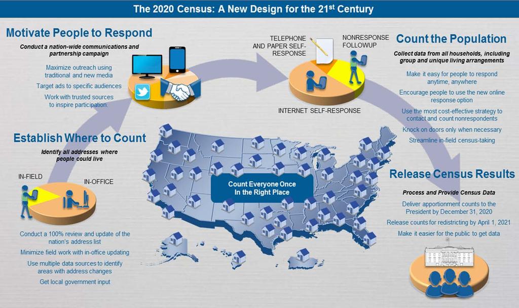
The 2020 Census A New Design for the 21 st Century
 The 2020 Census A New Design for the 21 st Century The Decennial Census Purpose: To conduct a census of population and housing and disseminate the results to the President, the States, and the American
The 2020 Census: Preparing for the Road Ahead
 The 2020 Census: Preparing for the Road Ahead Presentation to the National Association of Counties 2017 Annual Conference Columbus, OH July 23, 2017 The Decennial Census Purpose: To conduct a census of
The 2020 Census: A New Design for the 21 st Century Deirdre Dalpiaz Bishop Chief Decennial Census Management Division U.S.
 The 2020 Census: A New Design for the 21 st Century Deirdre Dalpiaz Bishop Chief Decennial Census Management Division U.S. Census Bureau National Conference of State Legislatures Fall Forum December 9,
Overview of Census Bureau Geographic Areas and Concepts
 Overview of Census Bureau Geographic Areas and Concepts Drew Stanislaw US Census Bureau WVAGP Annual Meeting Shepherdstown, WV June 13, 2011 1 What is the role of geography in the Census? The Census count
The 2020 Census Geographic Partnership Opportunities
 The 2020 Census Geographic Partnership Opportunities Brian Timko Branch Chief Address Data Collection and Products Branch Geography Division U.S. Census Bureau 1 Geographic Partnership Opportunities The
Version 2.2 April Census Local Update of Census Addresses Operation (LUCA) Frequently Asked Questions
 Frequently Asked Questions") Version 2.2 April 2017 2020 Census Local Update of Census Addresses Operation (LUCA) Frequently Asked Questions [This page intentionally left blank] 2020 Census LUCA Frequently Asked Questions TABLE OF
Version 2.2 April 2017 2020 Census Local Update of Census Addresses Operation (LUCA) Frequently Asked Questions [This page intentionally left blank] 2020 Census LUCA Frequently Asked Questions TABLE OF
Reengineering the 2020 Census
 Reengineering the 2020 Census John Thompson Director U.S. Census Bureau Lisa M. Blumerman Associate Director Decennial Census Programs U.S. Census Bureau Presentation to the Committee on National Statistics
2012 AMERICAN COMMUNITY SURVEY RESEARCH AND EVALUATION REPORT MEMORANDUM SERIES #ACS12-RER-03
 February 3, 2012 2012 AMERICAN COMMUNITY SURVEY RESEARCH AND EVALUATION REPORT MEMORANDUM SERIES #ACS12-RER-03 DSSD 2012 American Community Survey Research Memorandum Series ACS12-R-01 MEMORANDUM FOR From:
1 NOTE: This paper reports the results of research and analysis
 Race and Hispanic Origin Data: A Comparison of Results From the Census 2000 Supplementary Survey and Census 2000 Claudette E. Bennett and Deborah H. Griffin, U. S. Census Bureau Claudette E. Bennett, U.S.
2020 Census. Bob Colosi Decennial Statistical Studies Division February, 2016
 2020 Census Bob Colosi Decennial Statistical Studies Division February, 2016 Decennial Census Overview (1 of 2) Purpose: To conduct a census of population and housing and disseminate the results to the
Using Location-Based Services to Improve Census and Demographic Statistical Data. Deirdre Dalpiaz Bishop May 17, 2012
 Using Location-Based Services to Improve Census and Demographic Statistical Data Deirdre Dalpiaz Bishop May 17, 2012 U.S. Census Bureau Mission To serve as the leading source of quality data about the
2020 CENSUS LOCAL UPDATE OF CENSUS ADDRESSES OPERATION (LUCA) U.S. Census Bureau Geography Division
 U.S. Census Bureau Geography Division") 2020 CENSUS LOCAL UPDATE OF CENSUS ADDRESSES OPERATION (LUCA) U.S. Census Bureau Geography Division 1 Agenda 2020 Census Local Update of Census Addresses Operation (LUCA) Participation in LUCA Why participate
2020 CENSUS LOCAL UPDATE OF CENSUS ADDRESSES OPERATION (LUCA) U.S. Census Bureau Geography Division 1 Agenda 2020 Census Local Update of Census Addresses Operation (LUCA) Participation in LUCA Why participate
Census 2010 Participation Rates, Results for Alaska, and Plans for the 2020 Census
 Census 2010 Participation Rates, Results for Alaska, and Plans for the 2020 Census Evan Moffett, Assistant Division Chief Geographic Operations Decennial Census Management Division U.S. Census Bureau 2016
The 2020 Census Geographic Partnership Opportunities
 The 2020 Census Geographic Partnership Opportunities Web Adams Geographer, U.S. Census Bureau New York Regional Office 1 Geographic Partnership Opportunities The 2020 Census Local Update of Census Addresses
2020 Census Local Update of Census Addresses. Operation (LUCA) Promotion
 Promotion") 2020 Census Local Update of Census Addresses Atlanta Regional Office Managing Census Operations in: AL, FL, GA, LA, MS, NC, SC Operation (LUCA) Promotion 2020 Census Overview What is LUCA? Agenda LUCA
2020 Census Local Update of Census Addresses Atlanta Regional Office Managing Census Operations in: AL, FL, GA, LA, MS, NC, SC Operation (LUCA) Promotion 2020 Census Overview What is LUCA? Agenda LUCA
Census Data Boot Camp
 Census Data Boot Camp WVAGP Annual Meeting June 14, 2011 Laura Waggoner Katy Rossiter Drew Stanislaw US. Census Bureau Census Data Boot Camp Outline 2010 Census Overview Geographic Products and Mapping
Experiences with the Use of Addressed Based Sampling in In-Person National Household Surveys
 Experiences with the Use of Addressed Based Sampling in In-Person National Household Surveys Jennifer Kali, Richard Sigman, Weijia Ren, Michael Jones Westat, 1600 Research Blvd, Rockville, MD 20850 Abstract
The Census Bureau s Master Address File (MAF) Census 2000 Address List Basics
 Census 2000 Address List Basics") The Census Bureau s Master Address File (MAF) Census 2000 Address List Basics OVERVIEW The Census Bureau is developing a nationwide address list, often called the Master Address File (MAF) or the Census
The Census Bureau s Master Address File (MAF) Census 2000 Address List Basics OVERVIEW The Census Bureau is developing a nationwide address list, often called the Master Address File (MAF) or the Census
1980 Census 1. 1, 2, 3, 4 indicate different levels of racial/ethnic detail in the tables, and provide different tables.
 1980 Census 1 1. 1980 STF files (STF stands for Summary Tape File from the days of tapes) See the following WWW site for more information: http://www.icpsr.umich.edu/cgi/subject.prl?path=icpsr&query=ia1c
An Introduction to ACS Statistical Methods and Lessons Learned
 An Introduction to ACS Statistical Methods and Lessons Learned Alfredo Navarro US Census Bureau Measuring People in Place Boulder, Colorado October 5, 2012 Outline Motivation Early Decisions Statistical
2020 Census: How Communities Can Prepare
 2020 Census: How Communities Can Prepare Wednesday, November 16, 2017 Annual NM SDC Affiliates Meeting and Workshop Zimmerman Library, University of NM, Albuquerque, NM Presenters: Pauline Núñez, Partnership
Claritas Demographic Update Methodology Summary
 Claritas Demographic Update Methodology Summary 2006 by Claritas Inc. All rights reserved. Warning! The enclosed material is the intellectual property of Claritas Inc. (Claritas is a subsidiary of VNU,
Handout Packet. QuickFacts o Frequently Asked Questions
 Census Data Immersion Infopeople Webinar August 7, 2012 Handout Packet QuickFacts o Frequently Asked Questions Demographic Program Tips o 2010 Decennial Census o Population Estimates Program (PEP) o American
Working with United States Census Data. K. Mitchell, 7/23/2016 (no affiliation with U.S. Census Bureau)
") Working with United States Census Data K. Mitchell, 7/23/2016 (no affiliation with U.S. Census Bureau) Outline Types of Data Available Census Geographies & Timeframes Data Access on Census.gov website
Working with United States Census Data K. Mitchell, 7/23/2016 (no affiliation with U.S. Census Bureau) Outline Types of Data Available Census Geographies & Timeframes Data Access on Census.gov website
Road to the 2020 Census October 13, :15 p.m. 5:15 p.m. WEBINAR Presentation for: South Dakota - State Data Center s 5 th Annual Demography
 Road to the 2020 Census October 13, 2017 4:15 p.m. 5:15 p.m. WEBINAR Presentation for: South Dakota - State Data Center s 5 th Annual Demography Conference Presenter: Blanca Ramirez-Salazar, Partnership
Who s in Your Neighborhood? Using the American FactFinder. Salma Abadin and Carrie Koss Vallejo Data You Can Use
 Who s in Your Neighborhood? Using the American FactFinder Salma Abadin and Carrie Koss Vallejo Data You Can Use www.datayoucanuse.org Learning Objectives Learn what American FactFinder is and is not Become
Italian Americans by the Numbers: Definitions, Methods & Raw Data
 Tom Verso (January 07, 2010) The US Census Bureau collects scientific survey data on Italian Americans and other ethnic groups. This article is the eighth in the i-italy series Italian Americans by the
Census Data for Transportation Planning
 Census Data for Transportation Planning Transitioning to the American Community Survey May 11, 2005 Irvine, CA 1 Design Origins and Early Proposals Concept of rolling sample design Mid-decade census Proposed
American Community Survey: Sample Design Issues and Challenges Steven P. Hefter, Andre L. Williams U.S. Census Bureau Washington, D.C.
 American Community Survey: Sample Design Issues and Challenges Steven P. Hefter, Andre L. Williams U.S. Census Bureau Washington, D.C. 20233 Abstract In 2005, the American Community Survey (ACS) selected
Table 5 Population changes in Enfield, CT from 1950 to Population Estimate Total
 This chapter provides an analysis of current and projected populations within the Town of Enfield, Connecticut. A review of current population trends is invaluable to understanding how the community is
The 2010 Census: Count Question Resolution Program
 The 2010 Census: Count Question Resolution Program Jennifer D. Williams Specialist in American National Government December 7, 2012 CRS Report for Congress Prepared for Members and Committees of Congress
ESP 171 Urban and Regional Planning. Demographic Report. Due Tuesday, 5/10 at noon
 ESP 171 Urban and Regional Planning Demographic Report Due Tuesday, 5/10 at noon Purpose The starting point for planning is an assessment of current conditions the answer to the question where are we now.
An Overview of the American Community Survey
 An Overview of the American Community Survey Scott Boggess U.S. Census Bureau 2009 National Conference for Adult Education State Directors Washington, DC March 17, 2009 1 Overview What is the American
My Tribal Area: Census Data Overview & Access. Eric Coyle Data Dissemination Specialist U.S. Census Bureau
 My Tribal Area: Census Data Overview & Access Eric Coyle Data Dissemination Specialist U.S. Census Bureau AGENDA Overview of Census Bureau Programs and Datasets available Census Geographies Ways to Access
US Census. Thomas Talbot February 5, 2013
 US Census Thomas Talbot February 5, 2013 Outline Census Geography TIGER Files Decennial Census - Complete count American Community Survey Yearly Sample Obtaining Data - American Fact Finder - Census FTP
Claritas Update Demographics Methodology
 Claritas Update Demographics Methodology 2008 by Claritas Inc. All rights reserved. Warning! The enclosed material is the intellectual property of Claritas Inc. (Claritas is a subsidiary of The Nielsen
: Geocode File - Census Tract, Block-Group and Block. Codebook
 196815: Geocode File Census Tract, BlockGroup and Block Codebook Number of Variables 15 Friday June 17 8:49 AM 196815: Geocode File Census Tract, BlockGroup and Block RLS1 "RELEASE NUMBER" NUM(1.) Release
Employer Location file. Codebook
 232 Employer Location file Codebook Number of Variables 2 Wednesday July 8 28 :9 PM 232 Employer Location file EMPV "RELEASE NUMBER" NUM(.) Release number Release : 7/28, SAS proc geocode and proc ginside
The Road to 2020 Census
 The Road to 2020 Census Wednesday, May 17 th, 2017 9:00 am-12n North Central Texas Council of Governments 616 Six Flags Drive, Arlington, TX Arlington, TX 1 AGENDA OVERVIEW Decennial Census Basics, 2010
The American Community Survey Motivation, History, and Design. Workshop on the American Community Survey Havana, Cuba November 16, 2010
 The American Community Survey Motivation, History, and Design Workshop on the American Community Survey Havana, Cuba November 16, 2010 1 Outline What is the ACS? Motivation and design goals Key ACS historical
Census Data Determines Who Gets $300 Billion Annually Are You Getting Your Share?
 Census Data Determines Who Gets $300 Billion Annually Are You Getting Your Share? Hartford Foundation for Public Giving November 13, 2009 Jim Palma, Partnership Specialist Hartford Local Census Office
County Profiles Introduction. Introduction 1/17/2013. A compendium of Demographic, Housing, Education, Economic, and Agricultural Data
 County Profiles 2013 A compendium of Demographic, Housing, Education, Economic, and Agricultural Data Jan K. Vink and Joe D. Francis Nij Tontisirin, Sutee Anantsuksomsri and Johannes Plambeck Introduction
Quick Reference Guide
 U.S. Census Bureau Revised 07-28-13 Quick Reference Guide Demographic Program Comparisons Decennial Census o Topics Covered o Table Prefix Codes / Product Types o Race / Ethnicity Table ID Suffix Codes
Memorandum City of Lawrence Planning and Development Services
 Memorandum City of Lawrence Planning and Development Services TO: FROM: CC: David L. Corliss, City Manager Amy Miller, Long-Range Planner David Guntert, GIS Planner Scott McCullough, Planning & Development
Event History Calendar (EHC) Between-Wave Moves File. Codebook
 Between-Wave Moves File. Codebook") 2325 Event History Calendar (EHC) BetweenWave Moves File Codebook Number of Variables 23 Thursday July 2 28 4:5 PM 2325 Event History Calendar (EHC) BetweenWave Moves File EHCV "RELEASE NUMBER" NUM(.)
2325 Event History Calendar (EHC) BetweenWave Moves File Codebook Number of Variables 23 Thursday July 2 28 4:5 PM 2325 Event History Calendar (EHC) BetweenWave Moves File EHCV "RELEASE NUMBER" NUM(.)
2020 Census Program Update
 2020 Census Program Update Council of Professional Associations on Federal Statistics March 6, 2015 Deirdre Dalpiaz Bishop Chief, Decennial Management Division U.S. Census Bureau 1 Planning for the 2020
American Community Survey Overview
 American Community Survey Overview ACS Data Users Conference May 11, 2015 Gretchen Gooding American Community Survey Office 1 Outline American Community Survey (ACS) basics Resources for learning more
Geog 3340: Census Basics
 Geog 3340: Census Basics About the US Census Bureau Mandated by the U. S. Constitution to count the population Used: to apportion seats in the U.S. House of Representatives to define legislature districts,
Participant Statistical Areas Program for the 2010 Census. Vince Osier COPAFS Quarterly Meeting Washington, DC December 8, 2006
 Participant Statistical Areas Program for the 2010 Census Vince Osier COPAFS Quarterly Meeting Washington, DC December 8, 2006 1 Participant Statistical Areas Census Tracts Block Groups Census County Divisions
Burton Reist [signed] Acting Chief, Decennial Management Division
![Burton Reist [signed] Acting Chief, Decennial Management Division](/thumbs/74/71452686.jpg "Burton Reist [signed] Acting Chief, Decennial Management Division") This document was prepared by and for Census Bureau staff to aid in future research and planning, but the Census Bureau is making the document publicly available in order to share the information with
This document was prepared by and for Census Bureau staff to aid in future research and planning, but the Census Bureau is making the document publicly available in order to share the information with
Searching, Exporting, Cleaning, & Graphing US Census Data Kelly Clonts Presentation for UC Berkeley, D-lab March 9, 2015
 Searching, Exporting, Cleaning, & Graphing US Census Data Kelly Clonts Presentation for UC Berkeley, D-lab March 9, 2015 Learning Objectives To become familiar with the types of data published by the US
Local Update of Census Addresses Program Promotional Workshop
 Local Update of Census Addresses Program Promotional Workshop Will Your Community Be Ready? US Census Bureau Chicago Regional Office Stanley D. Moore, Regional Director 1 Welcome to the Local Update of
INTEGRATED COVERAGE MEASUREMENT SAMPLE DESIGN FOR CENSUS 2000 DRESS REHEARSAL
 INTEGRATED COVERAGE MEASUREMENT SAMPLE DESIGN FOR CENSUS 2000 DRESS REHEARSAL David McGrath, Robert Sands, U.S. Bureau of the Census David McGrath, Room 2121, Bldg 2, Bureau of the Census, Washington,
National Association of Regional Councils San Antonio, Texas October 23, 2017
 Preparing for the 2020 Census Role of State and Local Governments National Association of Regional Councils San Antonio, Texas October 23, 2017 @TexasDemography The best possible count in 2020 matters
SELECTED SOCIAL CHARACTERISTICS IN THE UNITED STATES American Community Survey 5-Year Estimates
 DP02 SELECTED SOCIAL CHARACTERISTICS IN THE UNITED STATES 2010-2014 American Community Survey 5-Year Estimates Supporting documentation on code lists, subject definitions, data accuracy, and statistical
Taming the Census TIGER:
 Taming the Census TIGER: Download TIGER Files using American FactFinder Eric Coyle Data Dissemination Specialist U.S. Census Bureau Outline ACS Overview Census Geography Accessing TIGER/ACS Data Products
2020 Census Geographic Partnership Programs. Update. Atlanta Regional Office Managing Census Operations in: AL, FL, GA, LA, MS, NC, SC
 2020 Census Geographic Partnership Programs Atlanta Regional Office Managing Census Operations in: AL, FL, GA, LA, MS, NC, SC Update Alabama State Data Center Conference Agenda 2020 Census Overview 2020
American Community Survey 5-Year Estimates
 DP02 SELECTED SOCIAL CHARACTERISTICS IN THE UNITED STATES 2012-2016 American Community Survey 5-Year Estimates Supporting documentation on code lists, subject definitions, data accuracy, and statistical
American Community Survey 5-Year Estimates
 DP02 SELECTED SOCIAL CHARACTERISTICS IN THE UNITED STATES 2011-2015 American Community Survey 5-Year Estimates Supporting documentation on code lists, subject definitions, data accuracy, and statistical
Census Data for Grant Writing Workshop Cowlitz-Wahkiakum Council of Governments. Heidi Crawford Data Dissemination Specialist U.S.
 Census Data for Grant Writing Workshop Cowlitz-Wahkiakum Council of Governments Heidi Crawford Data Dissemination Specialist U.S. Census Bureau Agenda Welcome and Introductions Overview of Census Data
Redistricting San Francisco: An Overview of Criteria, Data & Processes
 Redistricting San Francisco: An Overview of Criteria, Data & Processes Karin Mac Donald Q2 Data & Research, LLC October 5, 2011 1 Criteria in the San Francisco Charter: Districts must conform to all legal
Geographic Terms. Manifold Data Mining Inc. January 2016
 Geographic Terms Manifold Data Mining Inc. January 2016 The following geographic terms are adapted from the standard definition of Census geography from Statistics Canada. Block-face A block-face is one
2010 Census Data. Get Ready for Changes in Your 2014 AAPs. Ellen Shong & Associates, LLC 9/13/ Past EEO Tabulations
 2010 Census Data Get Ready for Changes in Your 2014 AAPs Ellen Shong & Associates, LLC 9/13/2013 1 Past EEO Tabulations ORC tabulation based on 1970 Census occupational data. Funded by private organization
Proceedings of the Annual Meeting of the American Statistical Association, August 5-9, 2001
 Proceedings of the Annual Meeting of the American Statistical Association, August 5-9, 2001 COVERAGE MEASUREMENT RESULTS FROM THE CENSUS 2000 ACCURACY AND COVERAGE EVALUATION SURVEY Dawn E. Haines and
Notes on the 2014 ACS 5-Year Estimates
 Notes on the 2014 ACS 5-Year Estimates Eric Guthrie, Michigan s State Demographer December 3, 2015 The U.S. Census Bureau has released the 2014 American Community Survey (ACS) 5-year estimates. The 5-year
FOR SALE Bees Ferry Rd & Main Rd/Hunt Club Charleston, SC. $1,250, Acres
 FOR SALE Bees Ferry Rd & Main Rd/Hunt Club $1,250,000 2.0 Acres Zoned Commercial in Charleston County Signalized intersection across at Hunt Club Subdivision & Main Rd Daily Traffic Count of 16,300 VPD
Virginia Employment Commission
 Small-Area Data and Graphs for New Kent County Virginia Employment Commission 703 East Main Street Richmond, Virginia 23219 Tel: (804) 786-8223 www.virginialmi.com Last updated: 2/6/2017 2:25:29 PM Table
Ensuring an Accurate Count of the Nation s Latinos in Census 2020
 Ensuring an Accurate Count of the Nation s Latinos in Census 2020 February 15, 2018 Arturo Vargas Executive Director NALEO Educational Fund ARTICLE I, SECTION 2 Representatives and direct Taxes shall be
Finding U.S. Census Data with American FactFinder Tutorial
 Finding U.S. Census Data with American FactFinder Tutorial Mark E. Pfeifer, PhD Reference Librarian Bell Library Texas A and M University, Corpus Christi mark.pfeifer@tamucc.edu 361-825-3392 Population
2020 Census: Researching the Use of Administrative Records During Nonresponse Followup
 2020 Census: Researching the Use of Administrative Records During Nonresponse Followup Thomas Mule U.S. Census Bureau July 31, 2014 International Conference on Census Methods Outline Census 2020 Planning
Claritas Demographic Update Methodology
 Claritas Demographic Update Methodology 2006 by Claritas Inc. All rights reserved. Warning! The enclosed material is the intellectual property of Claritas Inc. (Claritas is a subsidiary of VNU, a global
Twenty Year Forecasts of Population and Households, Louisville Economic Area
 Twenty Year Forecasts of Population and Households, Louisville Economic Area Economic Geography The U.S. Bureau of Economic Analysis (BEA) assigns every county in the nation to an economic area. BEA s
Using Administrative Records and the American Community Survey to Study the Characteristics of Undercounted Young Children in the 2010 Census
 Using Administrative Records and the American Community Survey to Study the Characteristics of Undercounted Young Children in the 2010 Census Leticia Fernandez, Rachel Shattuck and James Noon Center for
21,400 SF Pacific Hwy S. Kent, WA
 S 228TH ST S 231ST WAY MILITARY RD S 172,071 ADT N 21,400 SF 26100 Pacific Hwy S. 28,478 ADT 29,644 ADT S 240TH ST Home Improvement Warehouse S 22ND ST PACIFIC HWY S 26100 Pacific Hwy S, Kent AVAILABLE
Environmental Justice Tool Guide
 Environmental Justice Tool Guide This document is intended to accompany the Environmental Justice section of MnDOT s Highway Project Development Process. This document provides additional guidance to steps
GIS Data Sources. Thomas Talbot
 GIS Data Sources Thomas Talbot Chief, Environmental Health Surveillance Section Bureau of Environmental & Occupational Epidemiology New York State Department of Health Outline Sources of Data Census, health,
Become a 2010 Census Partner
 State and Local Governments Become a 2010 Census Partner In 2010, the U.S. Census Bureau will issue a call to action for every resident of our nation: Be Counted. The 2010 Census is important. It determines
Geocoding Techniques and Options for US and International Locations
 Federal GIS Conference 2014 February 10 11, 2014 Washington DC Geocoding Techniques and Options for US and International Locations Tosia Shall, Esri Doug Geverdt, Census Chuck Whittington, Census Types
Using Administrative Records for Imputation in the Decennial Census 1
 Using Administrative Records for Imputation in the Decennial Census 1 James Farber, Deborah Wagner, and Dean Resnick U.S. Census Bureau James Farber, U.S. Census Bureau, Washington, DC 20233-9200 Keywords:
A PROTOTYPE CONTINUOUS MEASUREMENT SYSTEM FOR THE U.S. CENSUS OF POPULATION AND HOUSING
 A PROTOTYPE CONTINUOUS MEASUREMENT SYSTEM FOR THE U.S. CENSUS OF POPULATION AND HOUSING Charles H. Alexander U.S. Bureau of the Census This paper reports the general results of research undertaken by Census
Understanding and Using the U.S. Census Bureau s American Community Survey
 Understanding and Using the US Census Bureau s American Community Survey The American Community Survey (ACS) is a nationwide continuous survey that is designed to provide communities with reliable and
2020 Census Update. Presentation to the Council of Professional Associations on Federal Statistics. December 8, 2017
 2020 Census Update Presentation to the Council of Professional Associations on Federal Statistics December 8, 2017 Deborah Stempowski, Chief Decennial Census Management Division The 2020 Census Where We
2020 Census Local Update of Census Addresses. Operation (LUCA) Promotion
 Promotion") 2020 Census Local Update of Census Addresses Atlanta Regional Office Managing Census Operations in: AL, FL, GA, LA, MS, NC, SC Operation (LUCA) Promotion 2020 Census Overview What is LUCA? Agenda LUCA
2020 Census Local Update of Census Addresses Atlanta Regional Office Managing Census Operations in: AL, FL, GA, LA, MS, NC, SC Operation (LUCA) Promotion 2020 Census Overview What is LUCA? Agenda LUCA
Understanding the Census A Hands-On Training Workshop
 Understanding the Census A Hands-On Training Workshop Vanderbilt Census Information Center March 23, 2003 U.S. Census Bureau The world s largest and most comprehensive data collection and analysis organization!!!
Census Pro Documentation
 Census Pro Documentation Introduction: Census Pro is our name for both our Census Demographics data, and our Data Extractor, which allows our clients to select just the data they need, in the format they
How Will the Changing U.S. Census Affect Decision-Making?
 How Will the Changing U.S. Census Affect Decision-Making? David A. Swanson University of California Riverside David.swanson@ucr.edu Prepared for the Lewis Seminar May 15, 2008 ACKNOWLEDGMENTS In addition
Virginia Employment Commission
 Small-Area Data and Graphs for Mecklenburg County Virginia Employment Commission 703 East Main Street Richmond, Virginia 23219 Tel: (804) 786-8223 www.virginialmi.com Last updated: 2/6/2017 2:24:09 PM
Improving the Quality of Geocoded Data
 Improving the Quality of Geocoded Data NCCCP & NPCR Conference April 15, 2009 Kevin C. Ward, PhD, CTR Georgia Center for Cancer Statistics Census Geography Geographic Unit State County Census Tract (average
Virginia Employment Commission
 Small-Area Data and Graphs for Lancaster County Virginia Employment Commission 703 East Main Street Richmond, Virginia 23219 Tel: (804) 786-8223 www.virginialmi.com Last updated: 2/6/2017 2:03:07 PM Table
2020 Census Local Update of Census Addresses Operation (LUCA) U.S. Census Bureau Geography Division
 U.S. Census Bureau Geography Division") 2020 Census Local Update of Census Addresses Operation (LUCA) U.S. Census Bureau Geography Division 1 Agenda 2020 Census LUCA Operation Participation in LUCA What is LUCA? Who Can Participate? Why participate?
2020 Census Local Update of Census Addresses Operation (LUCA) U.S. Census Bureau Geography Division 1 Agenda 2020 Census LUCA Operation Participation in LUCA What is LUCA? Who Can Participate? Why participate?
American Community Survey Accuracy of the Data (2014)
") American Community Survey Accuracy of the Data (2014) INTRODUCTION This document describes the accuracy of the 2014 American Community Survey (ACS) 1-year estimates. The data contained in these data products
American Community Survey Accuracy of the Data (2014) INTRODUCTION This document describes the accuracy of the 2014 American Community Survey (ACS) 1-year estimates. The data contained in these data products
PSC. Research Report. The Unexpectedly Large Census Count in 2000 and Its Implications P OPULATION STUDIES CENTER. Reynolds Farley. Report No.
 Reynolds Farley The Unexpectedly Large Census Count in 2000 and Its Implications Report No. 01-467 Research Report PSC P OPULATION STUDIES CENTER AT THE INSTITUTE FOR SOCIAL RESEARCH U NIVERSITY OF MICHIGAN
Prince William County
 Prince William County Quarterly Population Estimate Methods October 2016 Department of Information Technology Geographic Information Systems (GIS) Division WHY THE ESTIMATE IS HIGHER From Quarter 3 in
Acquiring and Using New Census Data to Understand Service Area, Gaps, and Need
 Acquiring and Using New Census Data to Understand Service Area, Gaps, and Need Agenda What types of Census data are available? Decennial, ACS, other we want mention today. Getting Census Data From American
Dallas Regional Office US Census Bureau
 The Census Bureau: Important Data Products for Every Community Paula Wright, Information Services Specialist Suzee Privett, Information Services Assistant Willie DeBerry, Partnership Specialist Lacey Loftin,
Making Sense of Census Data Robert Matthews, University of Alabama at Birmingham, Birmingham, Alabama
 Paper MPSF 074 Making Sense of Census Data Robert Matthews, University of Alabama at Birmingham, Birmingham, Alabama ABSTRACT The United States Census Bureau publishes a vast amount of data on many different
Overview of Demographic Data
 Overview of Demographic Data Michael Ratcliffe Geography Division US Census Bureau Mapping Sciences Committee October 20, 2014 Sources of Demographic Data Censuses Full enumeration, or counting, of the