Introducing Bentley Map VBA Development
|
|
|
- Crystal Cain
- 6 years ago
- Views:
Transcription


1 Introducing Bentley Map VBA Development Jeff Bielefeld
2 Session Overview Introducing Bentley Map VBA Development - In this session attendees will be provided an introductory look at what is required to begin developing custom MicroStation VBA applications for the Bentley Map platform. An overview of the XFM Feature Toolkit (XFT) will be provided to familiarize each attendee with the Bentley Map XFM object model. A number of sample Bentley Map VBA applications will be discussed and demonstrated, showing attendees common techniques used to create, locate and edit XFM feature instances. 2
3 Agenda Answer some of the most Frequently Asked Questions related to the Bentley Map product line. XML-Based Feature Modeling (XFM) Overview XFM Feature Toolkit (XFT) Overview Bentley Map VBA Examples 3
4 Bentley Map Frequently Asked Questions 4
5 Frequently Asked Questions Question - Why is the Bentley Map data model different than that of MicroStation or the one used for years in the MicroStation GeoGraphics product? Answer - While MicroStation has always provided an industry leading CAD engine, users requiring geospatial functionalities often need additional data modeling and geo-processing capabilities. For some 15 years, MicroStation GeoGraphics filled that gap by extending MicroStation into a feature-based system. Several years ago, users began requesting more extensible data modeling capabilities, thus the XML-Based Feature Modeling (XFM) framework was developed. 5
6 Frequently Asked Questions Question What is XFM? Answer As previously mentioned, the term XFM stands for XML-Based Feature Modeling which provides an extensible XML-based metadata driven framework upon which geospatial feature classes, their business properties and behaviors can be modeled. Let s take a brief look at some of the key benefits of the XFM data modeling platform. 6
7 XFM Key Benefits Provides an extensible framework upon which next generation infrastructure applications can be developed. Provides hierarchical data modeling capabilities. Provides support for disconnected workflows. Provides ability to model data from emerging data standards. Improves data interoperability capabilities. Integrated MicroStation undo/redo support. 7

8 XFM Key Benefits Adds value to applications by increasing interoperability with other Bentley geospatial products as well as additional data formats. 8

9 Frequently Asked Questions Question - I understand that Bentley Map provides improved interoperability with a number of industry standard data formats beyond those currently supported by MicroStation. Is this correct? Answer - Yes. From a user and developer perspective, Bentley Map provides native read/write support for many popular industry standard data formats. 9
10 Frequently Asked Questions Question What is a Bentley Map XFM feature? Answer In the simplest terms, a Bentley Map XFM feature is nothing more than one or more MicroStation elements with optionally one or more sets of nongraphic business properties. 10
11 Bentley Map XFM Feature Instance Root Feature Business Properties 11
12 Frequently Asked Questions Question How is a Bentley Map XFM feature different than a MicroStation element with a database linkage or a MicroStation GeoGraphics feature? Answer While many aspects of an XFM feature instance is similar to a database linked MicroStation element or MicroStation GeoGraphics feature instance there are some unique differences. Let s have a look at the key differences. 12


13 MicroStation Element Element Element Linkages Attribute Linkage Attribute Linkage Attributes Business Properties Business Properties 13
14 MicroStation GeoGraphics Feature Instance Element Feature Linkages Attribute Linkage Feature Linkage Attributes Business Properties Class Definition 14
15 Bentley Map XFM Feature Instance Root Feature Business Properties 15
16 Frequently Asked Questions Question What advantages do XFM features give me over regular MicroStation elements? Answer As previously stated, a Bentley Map XFM feature is nothing more than one or more MicroStation elements with optionally one or more sets of nongraphic business properties. 16
17 Bentley Map XFM Feature Instance Root Feature Business Properties Sub- Feature 17

18 Bentley Map XFM Feature Instance Root Feature Business Properties Sub- Feature Business Properties 18

19 Bentley Map XFM Feature Instance Root Feature Business Properties Sub- Feature Business Properties Sub- Feature Sub- Feature Sub- Feature Sub- Feature Business Properties Sub- Feature Business Properties Sub- Feature Business Properties 19
20 Frequently Asked Questions Question Can I use Bentley Map without converting my MicroStation elements to XFM feature instances? Answer Yes, using Dynamic Feature Scoring (DFS) technology, Bentley Map has the ability to automatically infer feature classes based upon various aspects of a MicroStation element such as level name and element type. 20
21 Frequently Asked Questions Question Can I still use MicroStation commands to manipulate XFM feature instances? Answer Yes. Bentley Map has been designed in such a way that allows users to take full advantage of the powerful MicroStation editing commands, while at the same time ensuring maintaining referential integrity between the graphic and non-graphic business properties. 21
22 Frequently Asked Questions Question Are there any existing tools which can help me get started converting my existing MicroStation data to the Bentley Map XFM format? Answer Yes, available upon request there exists an example VBA tool called XFMize which can be used to convert MicroStation data to the Bentley Map XFM format. 22
23 Frequently Asked Questions Question What is the Bentley Geospatial Administrator? Answer In the simplest terms, the Bentley Geospatial Administrator application is the class editor for the Bentley Map platform. 23
24 Frequently Asked Questions Question Is use of a Bentley Geospatial Administrator generated schema required? Answer No. Use of a Bentley Geospatial Administrator generated schema is not required. However there are some additional Bentley Map capabilities which are available whenever the Bentley Geospatial Administrator is used to pre-define a schema, feature classes and their behaviors. 24
25 Frequently Asked Questions Question What is required to get started with Bentley Map VBA development? Answer Bentley Map 25
 Bentley Map (standalone or MicroStation layered) Bentley Map")
26 Frequently Asked Questions Question Which editions of Bentley Map support VBA development? Answer All editions including: Bentley Map Enterprise (standalone) Bentley Map (standalone or MicroStation layered) Bentley Map PowerView (standalone) 26
27 Frequently Asked Questions Question What is XFT? Answer The term XFT stands for XFM Feature Toolkit and represents the Component Object Model (COM) for Bentley Map core functionalities. 27
28 Frequently Asked Questions Question What does the XFT object model provide? Answer The XFT object model presents a set of objects and events allowing programmatic access to XFM data modeling and core XFM capabilities. Let s have a closer look at what the XFT object model provides. 28

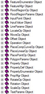
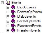
29 XFT Object Model 29
30 Frequently Asked Questions Question So now that I understand a bit more about XFM data modeling and the XFT object model, are Bentley Map VBA applications difficult to write? Answer No, not really. Using Bentley Map VBA, basic operations such as creating features and sub-features, adding business properties, setting symbology and locating features are actually quite simple. Let s have a look at a few brief examples. 30

31 VBA References 31
32 Bentley Map VBA Example Find MicroStation line or linestring elements and convert them to XFM feature instances. Create new elements and add those as sub-features. Add business properties to both the root and all subfeatures. Create a locate operation that searches the entire design file, fence contents or selection set for feature instances matching a particular search criteria. Load search results into the Data Browser application. 32

33 Create Feature Instances 33
34 Create Sub-Features 34

35 Add Business Properties 35

36 Locate Feature Instances 36
37 Frequently Asked Questions Question Can I use MicroStation VBA with Bentley Map VBA? Answer Yes and in some cases use of MicroStation VBA is required. For example, when working with the geometry of an XFM feature instance, element creation or manipulations are done using standard MicroStation VBA objects and methods. 37
38 Frequently Asked Questions Question By learning Bentley Map development using VBA and the XFT object model, what advantages do I gain? Answer Beyond having the ability to create VBA applications to create, manipulate and analyze Bentley Map XFM data, by learning the XFT object model a transition to.net development using C# or Visual Basic.NET becomes easier since XFT can also be used with COM interop. 38

 Visual Basic XFM Native C API Bentley")

")
39 Development Languages.NET COM MDL VBA C# Visual C++ Native C/C++ (unmanaged) MicroStation Object Library C++ (managed) Visual Basic XFM Native C API Bentley Map XFT Object Library Visual Basic.NET Microsoft Access MDL Interpreted Code (not recommended) MicroStation.NET Addins Microsoft Office (Excel, Word etc ) Bentley Map XFT Object Library Bentley Map XFT Object Library 39
40 Bentley Map Additional Resources 40


41 Documentation API Documentation Bentley Map XFM Programmer s Reference Guide Bentley Map VBA Programmer s Reference Guide Bentley Map GeoDataInterchange API Reference Bentley Map MapQuery API Reference Guide Bentley Map MDL Programmer s Reference Guide xft.chm gfc.chm GeoDataInterchangeAPI.chm MapQueryAPI.chm Map_SDK.chm 41


42 Geospatial Desktop Platform Extranet 42
43 Online Development Guide 44


44 Online Developer Notebooks 45


45 Be Together - Development Workshop 46
46 Additional Resources Be Communities Geospatial Desktop Forum Bentley Developer Network Group px Direct 47
47 Thank You 48
MicroStation CONNECT Edition - Information Modeling for Infrastructure Professionals
 MicroStation CONNECT Edition - Information Modeling for Infrastructure Professionals Urmas Jüriorg, CAD-süsteemide OÜ, Estonia 1 WWW.BENTLEY.COM 2016 Bentley Systems, Incorporated 2016 Bentley Systems,
Sharing Data Between CAD and GIS Systems. Lien Alpert Phil Sanchez
 Sharing Data Between CAD and GIS Systems Lien Alpert Phil Sanchez Session Overview Discuss current CAD strategies Outline ESRI s CAD support Demonstrate techniques for working with CAD data CAD Strategies
X11-Using the New Civil Geometry Tools
 X11-Using the New Civil Geometry Tools Joe Waxmonsky, PE Bentley Civil 2010 Bentley Systems, Incorpo ora 2010 Bentley Systems, Incorpora 2010 Nordic Civil Geometry 2 WWW.BENTLEY.COM Roads and Bridges 2010
Smart 3D Plant/Outfitting Curriculum Path & Training Guidelines
 Smart 3D Plant/Outfitting Curriculum Path & Training Guidelines Intergraph PPM recommends that new Smart 3D plant/outfitting users select one of the following training tracks described below. 1. System
Bentley Civil Update and Direction
 www. bentley. com Bentley Civil Update and Direction Mike Wilson Director, Software Development, Bentley Civil The cast of characters this year Bentley Civil Mike Wilson that would be me Director, Software
Welcome to another edition of Getting the Most. out of IBM U2. I'm Kenny Brunel, and I'll be your host for
 BRUNEL: Welcome to another edition of Getting the Most out of IBM U2. I'm Kenny Brunel, and I'll be your host for today's topic. Today, we'll take a look at IBM U2's implementation of Microsoft's.NET framework.
CMI User Day - Product Strategy
 CMI User Day - Product Strategy CMI User Day 2003 New Orleans, USA CMI User Day 2003 New Orleans, USA Tino Schlitt T-Systems PLM Solutions CATIA Metaphase Interface - Overview Integration of CATIA V4 /
Programme TOC. CONNECT Platform CONNECTION Client MicroStation CONNECT Edition i-models what is comming
 Bentley CONNECT CONNECT Platform MicroStation CONNECT Edition 1 WWW.BENTLEY.COM 2016 Bentley Systems, Incorporated 2016 Bentley Systems, Incorporated Programme TOC CONNECT Platform CONNECTION Client MicroStation
Design, Drawing and Sheet Composition
 Design, Drawing and Sheet Composition Tools, Technologies and Concepts 1 WWW.BENTLEY.COM 2018 Bentley Systems, Incorporated 2018 Bentley Systems, Incorporated 2 WWW.BENTLEY.COM 2018 Bentley Systems, Incorporated
Civil Product Update. Derricke Gray, Product Manager Bentley Civil Americas
 Civil Product Update Derricke Gray, Product Manager Bentley Civil Americas 1 WWW.BENTLEY.COM 2016 Bentley Systems, Incorporated 2016 Bentley Systems, Incorporated Agenda Civil Update o Where we are at
Bentleyuser.dk ÅRSMØDE 2011 Vejle,
 2011 Bentley Systems, Incorporated Bentleyuser.dk ÅRSMØDE 2011 Vejle, 14.+15.11.2011 Bentley OpenPlant Update Carsten Gerke Senior Sales Director Bentley Plant EMEA Today s Agenda 2010 Bentley Systems,
Bentley Rail Design Update. Robert Nice Bentley UK
 Bentley Rail Design Update Robert Nice Bentley UK The Global Rail Market is now worth 125 billion / year 59% Rolling stock 30% Infrastructure 11% Systems technology 2 WWW.BENTLEY.COM Regional Trends Source:
An Approach to Integrating Modeling & Simulation Interoperability
 An Approach to Integrating Modeling & Simulation Interoperability Brian Spaulding Jorge Morales MÄK Technologies 68 Moulton Street Cambridge, MA 02138 bspaulding@mak.com, jmorales@mak.com ABSTRACT: Distributed
GETTING YOUR DIGITAL HOUSE IN ORDER
 GETTING YOUR DIGITAL HOUSE IN ORDER STREAMLINING THE MBD AND DETAILING PROCESS WITH CREO Martin Neumüller Creo Product Management PTC Eindhoven, 2017 AGENDA 1. MBD opportunities and challenges 2. Creo
OpenPlant. Hayley Brown Industry Consultant, Bentley Plant Bentley Systems, In
 OpenPlant Hayley Brown Industry Consultant, Bentley Plant tley Systems, In co Introduction What is OpenPlant? OpenPlant is the branding for the next generation of applications and tools based on ISO 15926
2010 Bentley Systems, Incorporated. Point Clouds in MicroStation V8i
 Point Clouds in MicroStation V8i LiDAR Challenges Working with many forms of LiDAR (light detection and ranging) Laser Scanning Airborne LiDAR Mobile Mapping Systems All forms produce large data sets that
PELLISSIPPI STATE TECHNICAL COMMUNITY COLLEGE MASTER SYLLABUS MICROSTATION W/LAB CID 1200
 PELLISSIPPI STATE TECHNICAL COMMUNITY COLLEGE MASTER SYLLABUS MICROSTATION W/LAB CID 1200 Class Hours: 3.0 Credit Hours: 4.0 Laboratory Hours: 3.0 Date Revised: Spring 99 NOTE: This course is not designed
OpenRail SELECTseries 4 - Managing Geometry and Corridor Modeling
 2015 Bentley Systems, Incorporated OpenRail SELECTseries 4 - Managing Geometry and Corridor Modeling Robert Nice Senior Application Engineer Agenda: Why work in SELECTseries 4? Moving to SELECTseries 4
MicroStation V8i Intrinsically Geo-Coordinating Content for Project Design and Documentation
 MicroStation V8i Intrinsically Geo-Coorinating Content for Project Design an Documentation Chris Bober Bentley 2008 Bentley Intrinsic Geo-Coorination in V8i Priorities, Pressures an Solutions MicroStation
OpenBridge Modeler: What is it and how can I use it today?
 2015 Bentley Systems, Incorporated OpenBridge Modeler: What is it and how can I use it today? Steve Willoughby, Senior Application Engineer Agenda: Introducing OpenBridge Modeler OpenBridge Modeler Features
Archway Systems Bentley Bash 2011
 Archway Systems Bentley Bash 2011 Thank you for registering for the Archway Systems Bentley Bash at Rio Hondo College. This document will help you load the correct software for the training sessions. If
Agenda 2 Bentley Overview. Solutions. Bridges. Buildings 4 Bentley Overview
 Agenda Attendees will learn about how to improve efficiencies by transferring AutoPLANT, PlantSpace, PDS and 3D CAD models to engineering analysis piping and structural models. A demonstration will be
AGENDA. Effective Geodatabase Management. Presentation Title. Using Automation. Mohsen Kamal. Name of Speaker Company Name
 AGENDA Effective Geodatabase Management Presentation Title Using Automation Mohsen Kamal Name of Speaker Company Name Agenda Introducing the geodatabase What is a Schema? Schema Creation Options Geoprocessing
Up to Cruising Speed with Autodesk Inventor (Part 1)
") 11/29/2005-8:00 am - 11:30 am Room:Swan 1 (Swan) Walt Disney World Swan and Dolphin Resort Orlando, Florida Up to Cruising Speed with Autodesk Inventor (Part 1) Neil Munro - C-Cubed Technologies Ltd. and
11/29/2005-8:00 am - 11:30 am Room:Swan 1 (Swan) Walt Disney World Swan and Dolphin Resort Orlando, Florida Up to Cruising Speed with Autodesk Inventor (Part 1) Neil Munro - C-Cubed Technologies Ltd. and
UNIGIS University of Salzburg. Module: ArcGIS for Server Lesson: Online Spatial analysis UNIGIS
 1 Upon the completion of this presentation you should be able to: Describe the geoprocessing service capabilities Define supported data types input and output of geoprocessing service Configure a geoprocessing
AECOsim Building Designer. Quick Start Guide. Chapter 2 Making the Mass Model Intelligent Bentley Systems, Incorporated.
 AECOsim Building Designer Quick Start Guide Chapter 2 Making the Mass Model Intelligent 2012 Bentley Systems, Incorporated www.bentley.com/aecosim Table of Contents Making the Mass Model Intelligent...3
Bentley Substation 2010 Bentley Systems, Incorporated Håkan Norling Bentley Professional Services
 www.bentley.com Bentley Substation Håkan Norling Bentley Professional Services Agenda, 12 th of November 2010 Bentley s Substation design solution Integration of primary- and secondary design based on
Geospatial Keynote Nordic Civil konference I Vejle Bentley Systems, Incorporated 2016 Bentley Systems, Incorporated
 Geospatial Keynote Nordic Civil konference 07.11.2016 I Vejle 1 WWW.BENTLEY.COM 2016 Bentley Systems, Incorporated 2016 Bentley Systems, Incorporated Introduction Johannes Klick Senior Support Manager
Introduction to Planets. Hans Hofman Nationaal Archief Netherlands Barcelona, 27 March 2009
 Introduction to Planets Hans Hofman Nationaal Archief Netherlands Barcelona, 27 March 2009 Planets overview A 4-year research and technology development project co-funded by the European Union to address
New Trends in. Digital Reality. The Democratization of. Presenter: Trevor Leeson
 New Trends in Digital Reality The Democratization of Digital Reality Presenter: Trevor Leeson GPDIS_2017.ppt 1 Presenter Biography Trevor Leeson Starting his engineering career working for an automotive
e!cmi - web based CATIA Metaphase Interface
 e!cmi - web based CATIA Metaphase Interface e!cmi Release 2.0 for CF2.0 User s Manual Copyright 1999, 2000, 2001, 2002, 2003 T-Systems International GmbH. All rights reserved. Printed in Germany. Contact
2011 Bentley Systems, Incorporated Implementing GML, WMS and WFS in practice a software provider s viewpoint
 2011 Bentley Systems, Incorporated Implementing GML, WMS and WFS in practice a software provider s viewpoint Kimmo Soukki, Bentley Systems Finland Oy GI Norden 2011 Bentley and OGC Bentley is an active
PELLISSIPPI STATE TECHNICAL COMMUNITY COLLEGE MASTER SYLLABUS ADVANCED MECHANICAL DRAWING CID 1220
 PELLISSIPPI STATE TECHNICAL COMMUNITY COLLEGE MASTER SYLLABUS ADVANCED MECHANICAL DRAWING CID 1220 Class Hours: 3.0 Credit Hours: 4.0 Laboratory Hours: 3.0 Date Revised: Fall 00 NOTE: This course is not
2014 NCLUG Summer Conference. Workshops
 Workshops [CM Workshop] NCDOT Corridor Modeler (CM) Delta Training (3 Day) [SS2] Oak Thammavong, NCDOT Creating & Customizing templates presented by NCDOT, Oak Thammavong. The Advanced OpenRoads Technology
3D Modeling Demonstration
 2014 Bentley Systems, Incorporated 3D Modeling Demonstration Derricke Gray, Product Manager Bentley Civil Americas ESS Statewide Rollouts: 3D Modeling Engineering Content Management (ProjectWise) 2 WWW.BENTLEY.COM
Using Dynamic Views. Module Overview. Module Prerequisites. Module Objectives
 Using Dynamic Views Module Overview The term dynamic views refers to a method of composing drawings that is a new approach to managing projects. Dynamic views can help you to: automate sheet creation;
Looking into the Future Bentley Systems, Incorporated
 OPTRAM Looking into the Future Universal Truisms of Rail Too much of: Not Enough of: Infrastructure Problems Maintenance Budget 2 WWW.BENTLEY.COM Highest Priority Issues How Do You: 1) Know where to work
i-models Kansas City Revit Users Group September, 2013
 i-models Kansas City Revit Users Group September, 2013 Agenda i-model Definition Creation of i-models from Revit Reading an i-model Bentley Users collaborating with Revit Users Bentley View free Bentley
Full Contents. Survey V8.08 Essentials
 Section 1: Overview Essentials 1.1 Introduction... 3 Learning InRoads Survey... 3 Basic Rules... 3 How to Use This Guide... 4 Section Breakdown... 5 Section 1: Overview Essentials... 5 Section 2: Production
Using the ModelBuilder of ArcGIS 9 for Landscape Modeling
 Using the ModelBuilder of ArcGIS 9 for Landscape Modeling Jochen MANEGOLD, ESRI-Germany Geoprocessing in GIS A geographic information system (GIS) provides a framework to support planning tasks and decisions,
OpenBridge Designer Interoperability
 OpenBridge Designer Interoperability Steve Willoughby, Senior Application Engineer 1 WWW.BENTLEY.COM 2018 Bentley Systems, Incorporated 2018 Bentley Systems, Incorporated Agenda: OBM to LBC and Back OBM
Bentley Cloud Computing Strategy Present and Future
 Bentley Cloud Computing Strategy Present and Future Francois Valois MBA, Senior Product Manager Agenda Cloud Computing Bentley present Bentley future 2 WWW.BENTLEY.COM An analogy to the Cloud Computing
Military Tools for ArcGIS: An Introduction. Derek Foll Lyle Wright
 Military Tools for ArcGIS: An Introduction Derek Foll Lyle Wright Defense Solutions Current Capabilities Whole Organization Intelligence Analysis Civil-Military Operations Military Tools for ArcGIS Coordinate
Full Contents. InRoads Essentials
 Section 1: Overview Essentials 1.1 Introduction... 3 Learning InRoads... 3 Basic Rules... 3 How to Use This Guide... 4 Section Breakdown... 5 Section 1: Overview Essentials... 5 Section 2: Production Essentials...
ProConcrete. Gernot Jeromin Product Manager Bentley Systems, Incorporated
 ProConcrete Gernot Jeromin Product Manager ProConcrete 3D CAD Software for Concrete and Reinforcement 2 WWW.BENTLEY.COM What is ProConcrete AutoCAD Application MicroStation V8i version will be available
OmniWin 2015 Professional Designing and Nesting
 OmniWin 2015 Professional Designing and Nesting OmniWin 2015 is a simple, clear and fast designing and nesting software, which adapts intelligently to your machine and your cutting needs. It takes over
Full Contents. Essentials, Workbook
 Section 1: Overview Essentials 1.1 Introduction... 3 Learning InRoads... 3 Basic Rules... 3 How to Use This Guide... 4 Section Breakdown... 5 Section 1: Overview Essentials... 5 Section 2: Production Essentials...
Open Standard based Visualization Infrastructure for 3D Geospatial Information
 X3D Earth Open Standard based Visualization Infrastructure for 3D Geospatial Information 13 January 2008 / Web3D Korea Forum 유병현 Byounghyun Yoo Web3D Consortium Fellow MOVES (Modeling, Virtual Environment
Web3D Standards. X3D: Open royalty-free interoperable standard for enterprise 3D
 Web3D Standards X3D: Open royalty-free interoperable standard for enterprise 3D ISO/TC 184/SC 4 - WG 16 Meeting - Visualization of CAD data November 8, 2018 Chicago IL Anita Havele, Executive Director
ArcGIS Runtime: Analysis. Lucas Danzinger Mark Baird Mike Branscomb
 ArcGIS Runtime: Analysis Lucas Danzinger Mark Baird Mike Branscomb ArcGIS Runtime session tracks at DevSummit 2018 ArcGIS Runtime SDKs share a common core, architecture and design Functional sessions promote
Designing in the context of an assembly
 SIEMENS Designing in the context of an assembly spse01670 Proprietary and restricted rights notice This software and related documentation are proprietary to Siemens Product Lifecycle Management Software
TECHNICAL TRAINING ON ENERGY PLANNING LONG-RANGE ENERGY ALTERNATIVES PLANNING SYSTEM (LEAP) AND OTHER CONTEMPORARY PLANNING APPROACHES
 AND OTHER CONTEMPORARY PLANNING APPROACHES") TECHNICAL TRAINING ON ENERGY PLANNING LONG-RANGE ENERGY ALTERNATIVES PLANNING SYSTEM (LEAP) AND OTHER CONTEMPORARY PLANNING APPROACHES September 29 - October 3, 2014 Kigali, Rwanda 8:00-9:30 Participant
TECHNICAL TRAINING ON ENERGY PLANNING LONG-RANGE ENERGY ALTERNATIVES PLANNING SYSTEM (LEAP) AND OTHER CONTEMPORARY PLANNING APPROACHES September 29 - October 3, 2014 Kigali, Rwanda 8:00-9:30 Participant
PDS V8 SE Training Course Highlights
 PDS V8 SE Training Course Highlights Course Number Title Est. No of Days Per Enrollment (US $) On-Site Excl. Travel (US $) TPDS3113 PDS 3D Theory 4 2000 10000 TPDS3100 PDS Project Administration 4 2000
United Nations Statistics Division Programme in Support of the 2020 Round of Population and Housing Censuses
 United Nations Statistics Division Programme in Support of the 2020 Round of Population and Housing Censuses Srdjan Mrkić United Nations Statistics Division Definitions A population census is the total
Fundamentals of ModelBuilder
 Fundamentals of ModelBuilder Agenda An Overview of Geoprocessing Framework Introduction to ModelBuilder Basics of ArcToolbox Using ModelBuilder Documenting Models Sharing Models with Others Q & A Geoprocessing
Qt Developing ArcGIS Runtime Applications. Eric
 Qt Developing ArcGIS Runtime Applications Eric Bader @ECBader Agenda Getting Started Creating the Map Geocoding and Routing Geoprocessing Message Processing Working Offline The Next Release What s Coming
Analysis & Geoprocessing: Case Studies Problem Solving
 Analysis & Geoprocessing: Case Studies Problem Solving Shawn Marie Simpson Federal User Conference 2008 3 Overview Analysis & Geoprocessing Review What is it? How can I use it to answer questions? Case
Bentley speedikon V8i
 Bentley speedikon V8i Overview Bentley speedikon V8i Products of the speedikon product line Bentley speedikon Industrial V8i Bentley speedikon Architectural V8i Bentley speedikon ProjectEditor V8i Bentley
Railway Training Simulators run on ESRI ArcGIS generated Track Splines
 Railway Training Simulators run on ESRI ArcGIS generated Track Splines Amita Narote 1, Technical Specialist, Pierre James 2, GIS Engineer Knorr-Bremse Technology Center India Pvt. Ltd. Survey No. 276,
ABSTRACT. Keywords Virtual Reality, Java, JavaBeans, C++, CORBA 1. INTRODUCTION
 Tweek: Merging 2D and 3D Interaction in Immersive Environments Patrick L Hartling, Allen D Bierbaum, Carolina Cruz-Neira Virtual Reality Applications Center, 2274 Howe Hall Room 1620, Iowa State University
Sheet Metal OverviewChapter1:
 Sheet Metal OverviewChapter1: Chapter 1 This chapter describes the terminology, design methods, and fundamental tools used in the design of sheet metal parts. Building upon these foundational elements
Implementing BIM for infrastructure: a guide to the essential steps
 Implementing BIM for infrastructure: a guide to the essential steps See how your processes and approach to projects change as you adopt BIM 1 Executive summary As an ever higher percentage of infrastructure
How to Design and Submit a DOT Project with Civil 3D
 11/30/2006-5:00 pm - 6:30 pm Room:San Polo - 3503 (ISD Campus) How to Design and Submit a DOT Project with Civil 3D Seth Cohen - ProSoft NET CV35-2 This lab will delve into the workflows and processes
Bentley Rail Track Update
 Bentley Rail Track Update Robert Nice Bentley Systems UK Recent Past and Near Future Today, I will discuss recent enhancements to Bentley Rail Track. Some of these enhancements you may be very familiar
Best Practice: Corridor Modeling
 2014 Bentley Systems, Incorporated Best Practice: Corridor Modeling Presented by: Joe Waxmonsky PE, Bentley Civil 2 WWW.BENTLEY.COM 2014 Bentley Systems, Incorporated Best Practice: Corridor Modeling Agenda
The 8 th International Scientific Conference elearning and software for Education Bucharest, April 26-27, / X
 The 8 th International Scientific Conference elearning and software for Education Bucharest, April 26-27, 2012 10.5682/2066-026X-12-153 SOLUTIONS FOR DEVELOPING SCORM CONFORMANT SERIOUS GAMES Dragoş BĂRBIERU
BIM FOR INFRASTRUCTURE THE IMPACT OF TODAY S TECHNOLOGY ON BIM
 BIM for Infrastructure The Impact of Today s Technology on BIM 1 BIM FOR INFRASTRUCTURE THE IMPACT OF TODAY S TECHNOLOGY ON BIM How Technology can Transform Business Processes and Deliver Innovation 8
Are you ready for ISO 15926?
 Are you ready for ISO 15926? Glen Worrall Solutions Team Menu Bentley Systems ISO 15926 Semantic Web Federated Reference Data iring An Engineering Workflow An ISO 15926 Solution Review Click on button
Future of Bentley Plant applications: AutoPLant and OpenPlant
 1 WWW.BENTLEY.COM 2013 Bentley Systems, Incorporated Future of Bentley Plant applications: AutoPLant and Magnus Cullberg 2 WWW.BENTLEY.COM 2013 Bentley Systems, Incorporated AutoPLANT Modeler AutoPLANT
Drawing Management Brain Dump
 Drawing Management Brain Dump Paul McArdle Autodesk, Inc. April 11, 2003 This brain dump is intended to shed some light on the high level design philosophy behind the Drawing Management feature and how
Sustaining Water Infrastructure using Bentley Water Solutions
 Sustaining Water Infrastructure using Bentley Water Solutions February 2010. Slavco Velickov, PhD Water Industry Director, EMEA Agenda 1.Bentley at a Glance 2.Bentley Water Solutions 3.Water Products Overview
Please See NEXT PAGE for Class Selection
 SoCal Bentley Bash 2019 - January 11th - FRIDAY REGISTRATION FORM PLEASE PRINT - Use a separate form for each person registering For Admin Use Only *First Name *Last Name Company/School* *Address *City
Committee on Development and Intellectual Property (CDIP)
") E CDIP/21/12 REV. ORIGINAL: ENGLISH DATE: MAY 16, 2018 Committee on Development and Intellectual Property (CDIP) Twenty-First Session Geneva, May 14 to 18, 2018 PROJECT PROPOSAL FROM THE DELEGATIONS OF
E CDIP/21/12 REV. ORIGINAL: ENGLISH DATE: MAY 16, 2018 Committee on Development and Intellectual Property (CDIP) Twenty-First Session Geneva, May 14 to 18, 2018 PROJECT PROPOSAL FROM THE DELEGATIONS OF
National Standard Details Library An Electronic Library of Parametric CAD Details
 National Standard Details Library An Electronic Library of Parametric CAD Details James Nyambayo and Robert Amor Building Research Establishment Bucknalls Lane, Garston, Watford, WD2 7JR, UK Phone +44-1923-664168.
CMI CATIA TEAMCENTER INTEGRATION. CATIA V4/ V5 Teamcenter Enterprise Integration
 CMI CATIA TEAMCENTER INTEGRATION CATIA V4/ V5 Teamcenter Enterprise Integration 1 T-SYSTEMS TEAMCENTER CATIA INTEGRATION CATIA TEAMCENTER INTEGRATION OVERVIEW Product since 1995 Teamcenter as global PDM
COMOS Walkinside 10.2
 COMOS Walkinside 10.2 Why Immersive Training? Knowledge retention through learning Leverage the power of: Human graphic memory from 3D contextual simulations Repetition of scenario-driven work tasks Time-scale
Getting Started Guide
 SOLIDWORKS Getting Started Guide SOLIDWORKS Electrical FIRST Robotics Edition Alexander Ouellet 1/2/2015 Table of Contents INTRODUCTION... 1 What is SOLIDWORKS Electrical?... Error! Bookmark not defined.
Stream Design: From GEOPAK to HEC-Ras
 10 Stream Design: From GEOPAK to HEC-Ras OBJECTIVES Provide you with a general understanding of GEOPAK Cross Section Reports and their capability to generate geometric information for the HecRas program.
Webserver deployment on. Amazon Web Services using IAC tool Terraform
 Webserver deployment on Amazon Web Services using IAC tool Terraform Raghavendra Angara Department of Dev-Ops Engineering NexiiLabs 1. Abstract The purpose of this technical paper is to provide a solution
Extending X3D for Augmented Reality
 Extending X3D for Augmented Reality Seventh AR Standards Group Meeting Anita Havele Executive Director, Web3D Consortium www.web3d.org anita.havele@web3d.org Nov 8, 2012 Overview X3D AR WG Update ISO SC24/SC29
Design of Sanitary Sewer Network using Sewer GEMS V8i Software
 IJSTE - International Journal of Science Technology & Engineering Volume 2 Issue 01 July 2015 ISSN (online): 2349-784X Design of Sanitary Sewer Network using Sewer GEMS V8i Software Murugesh Katti Krishna
The Road to BIM through Open Collaboration and Connected Construction. Erkki Mäkinen. BIM World MUNICH 2018
 The Road to BIM through Open Collaboration and Connected Construction Erkki Mäkinen BIM World MUNICH 2018 Information flow in Construction Industry How documents are shared in construction industry in
Spatial Analysis with ArcGIS Pro. Krithica Kantharaj, Esri
 Spatial Analysis with ArcGIS Pro Krithica Kantharaj, Esri What is analysis? Analysis transforms raw data into information or knowledge Spatial analysis does this for geographic or spatial data Who? What?
Independent Communications Authority of South Africa Pinmill Farm, 164 Katherine Street, Sandton Private Bag X10002, Sandton, 2146
 Independent Communications Authority of South Africa Pinmill Farm, 164 Katherine Street, Sandton Private Bag X10002, Sandton, 2146 ANNEXURE A TECHNICAL SPECIFICATIONS ICASA 09/2018 1. Purpose of the Request
Any student may retake any class at any time and for any reason without additional charge.
 1 ENVISIONCAD ABOUT US Guaranteed Training 1 ENVISIONCAD ABOUT US EnvisionCAD is a provider of training solutions for MicroStation and select InRoads products. We also use our expertise to assist organizations
Features and Benefits Overview
 AutoCAD Mechanical 2004 DX Features and Benefits Overview Introduction This preview guide provides an overview of the features and benefits of AutoCAD Mechanical 2004 DX. For ease of use, this guide has
AutoPLANT Product Update
 AutoPLANT Product Update DK User Meeting 15 th November 2011 Chris Binns AutoPLANT Product Manager Agenda Introduction to me... Where we are today... AutoPLANT V8i (SELECTseries 3) Where we are going...
Leveraging PLM Components to Advance World s Infrastructure
 Leveraging PLM Components to Advance World s Infrastructure Sunand Sandurkar Director, Software Development 1 WWW.BENTLEY.COM 2018 Bentley Systems, Incorporated 2018 Bentley Systems, Incorporated Agenda
Bentley's AECOsim Energy Simulator and What Next for Energy Simulation
 Bentley's AECOsim Energy Simulator and What Next for Energy Simulation Drury B. Crawley, Ph.D., FASHRAE, BEMP, FIBPSA 26 January 2013 1 WWW.BENTLEY.COM 2013 Bentley Systems, Incorporated AECOsim Energy
Estimated Time Required to Complete: 45 minutes
 Estimated Time Required to Complete: 45 minutes This is the first in a series of incremental skill building exercises which explore sheet metal punch ifeatures. Subsequent exercises will address: placing
DOTD Plan Delivery. Baton Rouge, LA February 10, 2009 Presented by Hollis Ward DOTD Design Automation Manager
 DOTD Plan Delivery Moving Ahead Louisiana Transportation Conference 2009 Baton Rouge, LA February 10, 2009 Presented by Hollis Ward DOTD Design Automation Manager Design Automation Manager Role in Plan
Unit 15: Using Symbols and Attributes
 Unit 15: Using Symbols and Attributes Overview Many mechanical drawings use the same geometry over and over. The SI symbol, commonly found on Metric drawings, is one example. AutoCAD allows you create
CMW DELIVERABLES SPECIFICATION Version 1.0
 CMW DELIVERABLES SPECIFICATION Version 1.0 Code: CMW-CADD-STD-06 June 2012 CONTENTS 1 INTRODUCTION... 3 2 GENERAL... 3 3 GRAPHIC FORMAT... 3 4 CADD STANDARDS... 3 5 DELIVERY MEDIA AND FORMAT... 4 6 DRAWING
4. GAMBIT MENU COMMANDS
 GAMBIT MENU COMMANDS 4. GAMBIT MENU COMMANDS The GAMBIT main menu bar includes the following menu commands. Menu Item File Edit Solver Help Purposes Create, open and save sessions Print graphics Edit and/or
Integrating Survey, CAD and GIS into a Single Solution
 Pete KELSEY, USA Keywords: Engineering survey;geoinformation/gi;gps;photogrammetry;remote sensing; GIS; CAD; Civil 3D SUMMARY Any enterprise, public or private, that acquires, edits, or provides surveying,
Display and Draw Features
 CHAPTER 7 Display and Draw Features 7.1 Overview Feature / Function Tool Display or draw DTM features, such as contours, triangles, lattices, voids, islands, etc. DTM Menu Bar Load > DTM Features GEOPAK
Improving efficiency of water utilities: practical examples
 Improving efficiency of water utilities: practical examples Slavco Velickov, PhD - Water Industry Director EMEA Geospatial Forum, Rotterdam, 23-26 May 2016 1 WWW.BENTLEY.COM 2016 Bentley Systems, Incorporated
The role of SciELO on the road towards the Professionalization, Internationalization and Financial Sustainability of developing country journals
 The role of SciELO on the road towards the Professionalization, Internationalization and Financial Sustainability of developing country journals Alex Mendonça Online Submission Systems Coordinator, SciELO
EXPERT GROUP MEETING ON CONTEMPORARY PRACTICES IN CENSUS MAPPING AND USE OF GEOGRAPHICAL INFORMATION SYSTEMS New York, 29 May - 1 June 2007
 EXPERT GROUP MEETING ON CONTEMPORARY PRACTICES IN CENSUS MAPPING AND USE OF GEOGRAPHICAL INFORMATION SYSTEMS New York, 29 May - 1 June 2007 STATEMENT OF DR. PAUL CHEUNG DIRECTOR OF THE UNITED NATIONS STATISTICS
NEES CYBERINFRASTRUCTURE: A FOUNDATION FOR INNOVATIVE RESEARCH AND EDUCATION
 NEES CYBERINFRASTRUCTURE: A FOUNDATION FOR INNOVATIVE RESEARCH AND EDUCATION R. Eigenmann 1, T. Hacker 2 and E. Rathje 3 ABSTRACT This paper provides an overview of the vision and ongoing developments