Open Standard based Visualization Infrastructure for 3D Geospatial Information
|
|
|
- Dortha Quinn
- 6 years ago
- Views:
Transcription
1 X3D Earth Open Standard based Visualization Infrastructure for 3D Geospatial Information 13 January 2008 / Web3D Korea Forum 유병현 Byounghyun Yoo Web3D Consortium Fellow MOVES (Modeling, Virtual Environment and Simulation) Institute Naval Postgraduate School
2 Contents Web3D Consortium Working Groups X3D CAD X3D Earth Digital Earth X3D Earth Progress Applications Real time simulation infrastructure of satellite imagery Video fusion for security and surveillance X3D Earth Mash up 2 Byounghyun Yoo NPS
3 Web3D Consortium
4 X3D Specifications X3D graphics is defined by a set of specifications These specs are developed by working group volunteers as part of the Web3D Consortium Non profit organization with business, non profit, academic and professional members Efforts include editing, implementing and evaluating Specification results reviewed and approved by International Organization for Standards (ISO) 4 Byounghyun Yoo NPS

5 Current Working Groups X3D Earth H Anim ISO X3D WG Web3D Board CAD Networking UI 5 Byounghyun Yoo NPS
6 X3D CAD CAD Working Group TC184/SC4 3D Visualization ad hoc group Assessment for 36 requirements matrix 5 candidate format JT Open (13 Jan) U3D (27 Jan) X3D (10 Feb) Collada (24 Feb) 3D XML (10 Mar) Wiki will let us each edit and improve the responses. Adding images to illustrate example capabilities will also help us "tell the X3D story to TC184 reviewers, and eventually others as well. _Visualization_Requirements_for_X3D_CAD 6 Byounghyun Yoo NPS
7 X3D CAD X3D CAD Strategy Yumetech proposal as CAD component level 3, perhaps targeted to support lightweight/mobile applications and platforms EDF proposal as CAD component level 4, targeted to support fully capable desktop/laptop applications and platforms Harmonize terminology, make consistent KAIST parametric history allows broad translation of various CAD formats into X3D 7 Byounghyun Yoo NPS
8 X3D Earth


9 Geospatial Information Geospatial information for simulation Geobrowser Pros: Navigation, Visualization Cons: Lack of simulation capability and interoperability Geospatial Data Virtual Environment, Modeling and Simulation 9 Byounghyun Yoo NPS


10 X3D Earth Extensible 3D (X3D) Graphics Interoperability ISO approved Web standard for 3D Ensure 3D assets remain royalty free, achievable, usable, consistent with Web X3D Earth Build globe models: terrain, imagery, etc. Enable government generation of servers Web architecture: W3C, OGC standards X3D model of planet Earth Publicly available datasets X3D Geospatial component Interconnect, linkable 10 Byounghyun Yoo NPS

 Geospatial component for simple test model November 2006 Technical Requirement Workshop 11 Byounghyun")
11 X3D Earth Globe Implementation Progress The X3D Earth project is creating a standards based 3D visualization infrastructure for visualizing all manner of real world objects and information 2008 Maximum Resolution X3D Earth Globe Prototype of X3D Earth Server November 2007 Earth Globe Model X3D Earth working group meeting Multiple Globes with Geospatial component August 2007 Local Area Models (SIGGRAPH) Multi resolution (non geospatial component) Geospatial component for simple test model November 2006 Technical Requirement Workshop 11 Byounghyun Yoo NPS
12 X3D Geospatial Components Geospatial support The geospatial components of this part of ISO/IEC Provide support for geographic and geospatial applications This support includes the ability To embed geospatial coordinates in certain X3D nodes To support high precision geospatial modeling To handle large multi resolution terrain databases The Geospatial components include conventions that are defined by the Spatial Reference Model (see ISO/IEC 18026) 12 Byounghyun Yoo NPS
13 X3D Geospatial Component Support Level Prerequisites Nodes/Features Support 1 Core 1 GeoCoordinate All fields fully supported. Time 1 GeoElevationGrid G id All fields fully supported. td Networking 1 GeoLocation All fields fully supported. Grouping 3 GeoLOD All fields fully supported. Rendering 1 GeoMetadata All fields fully supported. Shape 1 GeoOrigin i All fields fully supported. td Geometry3D 1 GeoPositionInterpolator All fields fully supported. Interpolator 1 GeoTouchSensor All fields fully supported. Point device sensor 1 GeoViewpoint All fields fully supported. Navigation 1 2 Core 1 Time 1 Networking 1 Grouping 3 Rendering 1 Shape 1 Geometry3D 1 Interpolator 1 Environmental device sensor 1 Navigation 1 All Level 1 Geospatial nodes GeoProximitySensor GeoTransform All fields fully supported. Allfields fully supported. All fields fully supported. 13 Byounghyun Yoo NPS


14 X3D Terrain Tile Production Input: Geospatial data X3D simulation Output: Geo referenced real time simulation environment 14 Byounghyun Yoo NPS


15 Level of Detail Terrain tile Imagery tile 15 Byounghyun Yoo NPS


16 X3D Earth Globe Server side tile generation Geo referenced LOD 16 Byounghyun Yoo NPS
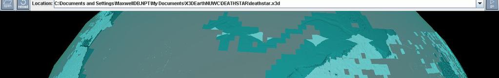


17 17 Byounghyun Yoo NPS NUWC's DNC to X3D
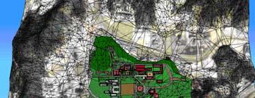
18 X3D Earth Level of Detail Structure 18 Byounghyun Yoo NPS
19 Georeferenced LOD with Imagery 19 Byounghyun Yoo NPS
20 20 Byounghyun Yoo NPS X3D Earth Server (NPS)
21 X3D Globe with OpenStreetMap p 21 Byounghyun Yoo NPS


22 Simulation using satellite imagery Satellite Imagery Building Virtual Environment 3D Simulation Framework Image Processing 3D Data Acquisition Modeling & Simulation Modeling & Simulation 22 Byounghyun Yoo NPS
23 3D Simulation using Satellite Imagery GIS system (ArcGIS) Google Earth Microsoft Virtual Earth NASA World Wind ESRI ArcExplorer X3D (X3D Earth) Resource data User data Rich Rich User data User data User data Interoperability High Low Low Low High High * User data Yes Yes Yes Yes Yes Yes overlay Real time 3D Low High High High Medium High Interactive Low Medium Medium Medium Low High simulation Analysis High Low Low Low Medium Low Usability for API API API SDK? XML, extension ECMAScript (Easier) Web Interface Extra Cost Yes Yes Extra Dev No Yes Cost (tools) High Free Free Free Free Free Cost (for business) High High High High? Low 23 Byounghyun Yoo NPS * X3D Earth is adding several OGC standards
24 Approach Motivation Real time 3D simulation using high resolution satellite imagery Problem statement Lack of interoperability b/w tools, information model and infrastructure of GIS, real time 3D graphics and simulation Approach Find open standard based information model Technical requirements Compare functionality, interoperability, usability, and run time framework Build framework and tools for information process Frame work for geospatial information processing from raw data dt to 3D simulation Open source tools 24 Byounghyun Yoo NPS
25 Information model Primary requirements Geospatial support Spatial reference frame, Earth geoids, et al. Open architecture Interoperability Real time 3D Interactive simulation Secondary requirements Metadata CAD layer User interaction and scripting Extensibility Advanced 3D graphics support 25 Byounghyun Yoo NPS
26 Geospatial Information Model GML/CityGML KML X3D SEDRIS SDTS * DXF Geospatial Feature Feature Geospatial Environmental Profile Geodata Component Component Data object Standards ISO, ISO, ISO, ISO, USGS Autodesk Organization OGC Google, OGC Web3D.org SEDRIS.org Interoperability Yes Yes Yes Yes Weak Weak Simulation N/A Limited, simple task Interactive profile Yes N/A N/A Real Time 3D Weak Yes Yes Limited Limited Limited Multimedia N/A Limited Yes N/A N/A N/A Run time Limited Google Earth, Multiple Limited N/A N/A Architecture geobrowsers implementation Advanced 3D N/A N/A Shader support N/A N/A N/A 26 Byounghyun Yoo NPS * Spatial Data Transfer Standards, USGS
27 Primary Requirements Open 3D Graphics Standards Table by courtesy of Nathan Crews, Autodesk, Inc, 2008 XAML U3D X3D Collada KML OpenHSF Is XML? Yes No Yes Yes Yes No Standards Organization Microsoft ECMA ISO Web3D.org Collada.org Google.com / OGC GeoSpatial Support No No Yes No Yes No Shader Support No No Cg, GLSL, HLSL Cg, GLSL, No No HLSL Textures Yes Yes Yes Yes No Yes Animations Yes Yes Yes Yes No Yes Multi Textures Yes No Yes Yes No Yes Meta data support Yes Yes Yes Yes Yes Yes Secondary Requirements Additional geometric Yes No Yes No No Yes compression beyond zip compression CAD layer support No Yes Yes No Yes Yes User interaction & Yes Yes Yes No No Yes scripting 27 Byounghyun Yoo NPS OpenHSF.org
28 Evaluation result Evaluation of Open Standards Geospatial standards Comparison over 6 geospatial information model 3D graphics standards Comparison over 6 open standards and over 42 graphics file format 3D graphics standards Real time simulation requirements Geospatial standards Geospatial requirements 28 Byounghyun Yoo NPS X3D Geospatial component ISO/IEC 19775


29 Proposed X3D Terrain Tile Production Satellite Imgery Elevation 29 Byounghyun Yoo NPS


30 Real time 3D terrain models 30 Byounghyun Yoo NPS


31 Movie Texture Movie Texture Mapping Movie Texture Image를가상의스크린에투사하여 Texture Mapping Camera Model과 Projection Model의상관관계 Viewpoint Camera Texture Image Virtual Screen View Volume View Volume of the Camera Projective Texture Image on the scene Recorded Image 31 Byounghyun Yoo NPS


32 Security and Surveillance X3D 기반 Video Fusion 시스템의구성 X3D Video Projection X3D Terrain Generation Georeferencing, Movie Texture Mapping Video Stream Terrain Elevation 3D 공간정보기반가상환경 Camera Information (Lens, Focal Length, FoV) Reference Information (Location, Orientation) X3D Material Appearance X3D Model Georeferencing Typed Metadata Aerial Photograph 3D Building Model 32 Byounghyun Yoo NPS
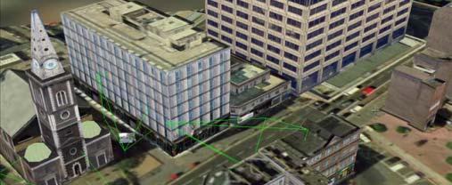


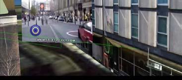


33 33 Byounghyun Yoo NPS Video Fusion
34 Mesh up Algeria Radio Tower
35 Video 2 Synthetic World
36 Byounghyun Yoo, Ph.D. Wb3DC Web3D Consortium Fll Fellow Modeling, Virtual Environments and Simulation Institute Naval Postgraduate School Web: X3D Earth: earth.nps.edu edu Web3D Consortium: earth 36 Byounghyun Yoo NPS
Extending X3D for Augmented Reality
 Extending X3D for Augmented Reality Seventh AR Standards Group Meeting Anita Havele Executive Director, Web3D Consortium www.web3d.org anita.havele@web3d.org Nov 8, 2012 Overview X3D AR WG Update ISO SC24/SC29
Web3D and X3D Overview
 Web3D and X3D Overview Web3D Consortium Anita Havele, Executive Director Anita.havele@web3d.org March 2015 Market Needs Highly integrated interactive 3D worlds Cities - Weather - building - Engineering
Extensible 3D (X3D) Graphics and X3D Earth for Web-Interoperable Modeling, Simulation and Visualization
 Graphics and X3D Earth for Web-Interoperable Modeling, Simulation and Visualization") Extensible 3D (X3D) Graphics and X3D Earth for Web-Interoperable Modeling, Simulation and Visualization Demonstrating Potential for New Capabilities 21 July 2009 Don Brutzman Naval Postgraduate School
Extensible 3D (X3D) Graphics and X3D Earth for Web-Interoperable Modeling, Simulation and Visualization Demonstrating Potential for New Capabilities 21 July 2009 Don Brutzman Naval Postgraduate School
Web3D.org. March 2015 Anita Havele, Executive Director
 March 2015 Anita Havele, Executive Director Anita.havele@web3d.org Market Needs for 3D Highly integrated interactive 3D worlds Cities - Weather - building - Engineering - scientific Web as the delivery
Video Requirements for Web-based Virtual Environments using Extensible 3D (X3D) Graphics
 Graphics") Video Requirements for Web-based Virtual Environments using Extensible 3D (X3D) Graphics Don Brutzman and Mathias Kolsch Web3D Consortium Naval Postgraduate School, Monterey California USA brutzman@nps.edu
Video Requirements for Web-based Virtual Environments using Extensible 3D (X3D) Graphics Don Brutzman and Mathias Kolsch Web3D Consortium Naval Postgraduate School, Monterey California USA brutzman@nps.edu
Mixed and Augmented Reality Reference Model as of January 2014
 Mixed and Augmented Reality Reference Model as of January 2014 10 th AR Community Meeting March 26, 2014 Author, Co-Chair: Marius Preda, TELECOM SudParis, SC29 Presented by Don Brutzman, Web3D Consortium
Web3D Standards. X3D: Open royalty-free interoperable standard for enterprise 3D
 Web3D Standards X3D: Open royalty-free interoperable standard for enterprise 3D ISO/TC 184/SC 4 - WG 16 Meeting - Visualization of CAD data November 8, 2018 Chicago IL Anita Havele, Executive Director
Scalable geospatial 3D client applications in X3D - Interactive, online and in real-time
 Scalable geospatial 3D client applications in X3D - Interactive, online and in real-time Dipl.Inform.Univ Peter Schickel CEO Bitmanagement Software Vice President Web3D Consortium, Mountain View, USA OGC/Web3D
ISO/IEC JTC 1 N 13141
 ISO/IEC JTC 1 N 13141 ISO/IEC JTC 1 Information technology Secretariat: ANSI (United States) Document type: Title: Status: Business Plan Business Plan for JTC 1/SC 24, Computer Graphics, Image Processing
ISO JTC 1 SC 24 WG9 G E R A R D J. K I M K O R E A U N I V E R S I T Y
 New Work Item Proposal: A Standard Reference Model for Generic MAR Systems ISO JTC 1 SC 24 WG9 G E R A R D J. K I M K O R E A U N I V E R S I T Y What is a Reference Model? A reference model (for a given
X3D Capabilities for DecWebVR
 X3D Capabilities for DecWebVR W3C TPAC Don Brutzman brutzman@nps.edu 6 November 2017 Web3D Consortium + World Wide Web Consortium Web3D Consortium is W3C Member as standards liaison partner since 1 April
Activities at SC 24 WG 9: An Overview
 Activities at SC 24 WG 9: An Overview G E R A R D J. K I M, C O N V E N E R I S O J T C 1 S C 2 4 W G 9 Mixed and Augmented Reality (MAR) ISO SC 24 and MAR ISO-IEC JTC 1 SC 24 Have developed standards
ISO/IEC JTC 1 VR AR for Education
 ISO/IEC JTC 1 VR AR for January 21-24, 2019 SC24 WG9 & Web3D Meetings, Seoul, Korea Myeong Won Lee (U. of Suwon) Requirements Learning and teaching Basic components for a virtual learning system Basic
THE CURRENT STATUS AND FUTURE PLAN OF THE ISO PROJECT
 THE CURRENT STATUS AND FUTURE PLAN OF THE ISO 19130 PROJECT Liping Di a*, Wolfgang Kresse b, Ben Kobler c a Laboratory for Advanced Information Technology and Standards (LAITS),George Mason University,
X3D Graphics for Web Authors. X3D-Edit Update. Web3D Consortium Korea Chapter Seoul, 7-8 December Don Brutzman
 X3D Graphics for Web Authors X3D-Edit Update Web3D Consortium Korea Chapter Seoul, 7-8 December 2009 Don Brutzman Naval Postgraduate School Monterey California USA Motivation Teach X3D to anyone who can
The power of virtual globes for valorising cultural heritage and enabling sustainable tourism: NASA World Wind applications
 The power of virtual globes for valorising cultural heritage and enabling sustainable tourism: NASA World Wind applications Maria Antonia Brovelli*, Patrick Hogan**, Marco Minghini*, Giorgio Zamboni* *
Managing Imagery and Raster Data. Peter Becker
 Managing Imagery and Raster Data Peter Becker ArcGIS is a Comprehensive Imagery Platform Empowering you to make informed decisions System of Engagement System of Insight Extract Information from Imagery
instantreality Framework for AR and VR application Johannes Behr Fraunhofer IGD A4
 instantreality Framework for AR and VR application Johannes Behr Fraunhofer IGD A4 Johannes.Behr@igd.fraunhofer.de instantreality Introduction and Motivation System-feature and Architecture Application
SC24 Study Group: Systems Integration Visualization (SIV)
") SC24 Study Group: Systems Integration Visualization (SIV) ISO/IEC JTC 1/SC24 Meetings 20-25 January 2019 Seoul, Korea Peter Ryan 1 and Myeong Won Lee 2 1 Defence Science & Technology Group Australia 2
SC24 Study Group: Systems Integration Visualization (SIV) ISO/IEC JTC 1/SC24 Meetings 20-25 January 2019 Seoul, Korea Peter Ryan 1 and Myeong Won Lee 2 1 Defence Science & Technology Group Australia 2
Topics VRML. The basic idea. What is VRML? History of VRML 97 What is in it X3D Ruth Aylett
 Topics VRML History of VRML 97 What is in it X3D Ruth Aylett What is VRML? The basic idea VR modelling language NOT a programming language! Virtual Reality Markup Language Open standard (1997) for Internet
Geocoding DoubleCheck: A Unique Location Accuracy Assessment Tool for Parcel-level Geocoding
 Measuring, Modelling and Mapping our Dynamic Home Planet Geocoding DoubleCheck: A Unique Location Accuracy Assessment Tool for Parcel-level Geocoding Page 1 Geocoding is a process of converting an address
Activities at SC 24 WG 9: An Overview
 Activities at SC 24 WG 9: An Overview G E R A R D J. K I M, C O N V E N E R I S O J T C 1 S C 2 4 W G 9 S E O U L, J A N U A R Y, 2 0 1 9 Mixed and Augmented Reality (MAR) ISO SC 24 and MAR ISO-IEC JTC
bhuvan Gateway to Indian Earth Observation Data Products & Services ISRO s Geoportal
 bhuvan ISRO s Geoportal Gateway to Indian Earth Observation Data Products & Services One-stop versatile Web based Earth Observation Data Products & Services Interactive 3D Environment Societal Applications
NAVAL POSTGRADUATE SCHOOL
 NPS-MV-07-003 NAVAL POSTGRADUATE SCHOOL MONTEREY, CALIFORNIA Extensible 3D (X3D) Earth Technical Requirements Workshop Summary Report Don Brutzman, Amela Sadagic and Terry Norbraten, Eds. 01 August 2007
Downloading and formatting remote sensing imagery using GLOVIS
 Downloading and formatting remote sensing imagery using GLOVIS Students will become familiarized with the characteristics of LandSat, Aerial Photos, and ASTER medium resolution imagery through the USGS
Programme TOC. CONNECT Platform CONNECTION Client MicroStation CONNECT Edition i-models what is comming
 Bentley CONNECT CONNECT Platform MicroStation CONNECT Edition 1 WWW.BENTLEY.COM 2016 Bentley Systems, Incorporated 2016 Bentley Systems, Incorporated Programme TOC CONNECT Platform CONNECTION Client MicroStation
Generating Virtual Environments by Linking Spatial Data Processing with a Gaming Engine
 Generating Virtual Environments by Linking Spatial Data Processing with a Gaming Engine Christian STOCK, Ian D. BISHOP, and Alice O CONNOR 1 Introduction As the general public gets increasingly involved
Microsoft ESP Developer profile white paper
 Microsoft ESP Developer profile white paper Reality XP Simulation www.reality-xp.com Background Microsoft ESP is a visual simulation platform that brings immersive games-based technology to training and
Introduction to standardization activities for indoor navigation - IEEE MDR, ISO TC204, and ISO TC211-
 IPIN/ISC Map Subcommittee Introduction to standardization activities for indoor navigation - IEEE MDR, ISO TC204, and ISO TC211- Jan. 22, 2018 Ryan, ETRI (Electronics and Telecommunications Research Institute),
Computer Graphics. Spring April Ghada Ahmed, PhD Dept. of Computer Science Helwan University
 Spring 2018 10 April 2018, PhD ghada@fcih.net Agenda Augmented reality (AR) is a field of computer research which deals with the combination of real-world and computer-generated data. 2 Augmented reality
Geographic information - Imagery and gridded data. Wolfgang Kresse
 Geographic information - Imagery and gridded data Wolfgang Kresse kresse@fh-nb.de Imagery Data taken by IRS-1C and LandsatTM Eftas, Münster, Germany Gridded data Grid Value Matrix Associated Metadata Attribute
Web3D Consortium Medical WG Update. Nicholas F. Polys, PhD Virginia Tech Web3D Consortium
 Web3D Consortium Medical WG Update Nicholas F. Polys, PhD Virginia Tech Web3D Consortium Topics Introduction Rendering Volume Rendering Extensions Other Medical data 3D printing (NIH 3D Print Exchange)
Integrated Data Handling and Visualization
 Integrated Data Handling and Visualization Module of Remote Sensing and GIS Integration Course 2017 Lammert Kooistra, Ron van Lammeren, John Stuiver Environmental Resource Management in the Anthropocene
Project Overview Mapping Technology Assessment for Connected Vehicle Highway Network Applications
 Project Overview Mapping Technology Assessment for Connected Vehicle Highway Network Applications AASHTO GIS-T Symposium April 2012 Table Of Contents Connected Vehicle Program Goals Mapping Technology
Services Overview. Northeast Blueprint
 Services Overview 2D CAD Conversions Paper to CAD 2D CAD Conversions Construction Engineering / CAD Services Construction Markups Consultant Drawings Coordinated Drawings As -Builts Steel Structural Detailing
ArcGIS Online Content
 Esri International User Conference San Diego, California Technical Workshops July 25, 2012 ArcGIS Online Content Deane Kensok Sarah Osborne Today s Agenda Overview Esri Content Portfolio - What s Available,
Introducing Bentley Map VBA Development
 Introducing Bentley Map VBA Development Jeff Bielefeld Session Overview Introducing Bentley Map VBA Development - In this session attendees will be provided an introductory look at what is required to
Google Earth Workshop Version 5
 Google Earth Workshop Version 5 From the Mitchell Home Page (http://mitchell.needham.k12.ma.us) Technology > For Teachers > Prof Dev > Google Earth Getting to Know Google Earth Taken from Google Earth
Building Java Apps with ArcGIS Runtime SDK
 Building Java Apps with ArcGIS Runtime SDK Vijay Gandhi, Elise Acheson, Eric Bader Demo Source code: https://github.com/esri/arcgis-runtime-samples-java/tree/master/devsummit-2014 Video Recording: http://video.esri.com
Reference number of working document: ISO/IEC JTC 1/SC 24 N 000
 Reference number of working document: ISO/IEC JTC 1/SC 24 N 000 Date: 2014-08-00 Reference number of document: Committee identification: ISO/IEC JTC 1/SC 24/WG 6 Secretariat: Information technology Computer
Thursday June 18, 2015 (Web3D Consortium Open Meeting)
") Thursday June 18, 2015 (Web3D Consortium Open Meeting) Hall MINOS II Time Registration 09:00-09:30 Efficient binary encoding: SRC geometric compression + EXI information compression 09:30-10:30 (Limper,
Thursday June 18, 2015 (Web3D Consortium Open Meeting) Hall MINOS II Time Registration 09:00-09:30 Efficient binary encoding: SRC geometric compression + EXI information compression 09:30-10:30 (Limper,
World-Wide Navigational Warning Service Sub-Committee WWNWS-5 Monaco, 1-4 October S-100 Basics Background Brief
 International Hydrographic Organization World-Wide Navigational Warning Service Sub-Committee WWNWS-5 Monaco, 1-4 October 2013 S-100 Basics Background Brief Gilles Bessero 15:29 1 S-100 Basics S-100 -
3D Virtual Training Systems Architecture
 3D Virtual Training Systems Architecture January 21-24, 2018 ISO/IEC JTC 1/SC 24/WG 9 & Web3D Meetings Seoul, Korea Myeong Won Lee (U. of Suwon) Virtual Training Systems Definition Training systems using
PASSENGER. Story of a convergent pipeline. Thomas Felix TG - Passenger Ubisoft Montréal. Pierre Blaizeau TWINE Ubisoft Montréal
 PASSENGER Story of a convergent pipeline Thomas Felix TG - Passenger Ubisoft Montréal Pierre Blaizeau TWINE Ubisoft Montréal Technology Group PASSENGER How to expand your game universe? How to bridge game
Spatial Analysis with ArcGIS Pro. Krithica Kantharaj, Esri
 Spatial Analysis with ArcGIS Pro Krithica Kantharaj, Esri What is analysis? Analysis transforms raw data into information or knowledge Spatial analysis does this for geographic or spatial data Who? What?
High Performance Visualization : Scaling Rendering and Perception
 High Performance Visualization : Scaling Rendering and Perception Dr. Nicholas Polys, Director of Visual Computing, VT Information Technology Affiliate Professor, Computer Science Topic Overview Trends
Moving Web 3d Content into GearVR
 Moving Web 3d Content into GearVR Mitch Williams Samsung / 3d-online GearVR Software Engineer August 1, 2017, Web 3D BOF SIGGRAPH 2017, Los Angeles Samsung GearVR s/w development goals Build GearVRf (framework)
Standards for Linear Referencing
 Standards for Linear Referencing Dr. Paul Scarponcini Bentley Transportation Data Management March 3, 2004 Rapid City, South Dakota 2004 Bentley Systems, Inc. Linear Referencing PROJECT project: name:
Fundamentals of Remote Sensing
 Climate Variability, Hydrology, and Flooding Fundamentals of Remote Sensing May 19-22, 2015 GEO-Latin American & Caribbean Water Cycle Capacity Building Workshop Cartagena, Colombia 1 Objective To provide
PROGRESS ON THE SIMULATOR AND EYE-TRACKER FOR ASSESSMENT OF PVFR ROUTES AND SNI OPERATIONS FOR ROTORCRAFT
 PROGRESS ON THE SIMULATOR AND EYE-TRACKER FOR ASSESSMENT OF PVFR ROUTES AND SNI OPERATIONS FOR ROTORCRAFT 1 Rudolph P. Darken, 1 Joseph A. Sullivan, and 2 Jeffrey Mulligan 1 Naval Postgraduate School,
SkylineGlobe 6.5 Technology Overview
 SkylineGlobe 6.5 Technology Overview w w w. S k y l i n e G l o b e. c o m Contents SKYLINEGLOBE PRODUCTS... 4 SKYLINEGLOBE ENTERPRISE... 5 SKYLINEGLOBE ENTERPRISE BUNDLE COMPONENTS... 6 TERRABUILDER...
Exploring Virtual Reality (VR) with ArcGIS. Euan Cameron Simon Haegler Mark Baird
 with ArcGIS. Euan Cameron Simon Haegler Mark Baird") Exploring Virtual Reality (VR) with ArcGIS Euan Cameron Simon Haegler Mark Baird Agenda Introduction & Terminology Application & Market Potential Mobile VR with ArcGIS 360VR Desktop VR with CityEngine
Exploring Virtual Reality (VR) with ArcGIS Euan Cameron Simon Haegler Mark Baird Agenda Introduction & Terminology Application & Market Potential Mobile VR with ArcGIS 360VR Desktop VR with CityEngine
Web of Things for Connected Vehicles. Soumya Kanti Datta Communication Systems Department
 Web of Things for Connected Vehicles Soumya Kanti Datta Communication Systems Department Email: Soumya-Kanti.Datta@eurecom.fr Roadmap Introduction Web of Things (WoT) Architecture & Components Prototyping
Why? A Documentation Consortium Ted Habermann, NOAA. Documentation: It s not just discovery... in global average
 A Documentation Consortium Ted Habermann, NOAA i checked my 2002 email archives, and here is what i found out: it appears that the current 3rd generation algorithm was implemented into operations around
Using the ModelBuilder of ArcGIS 9 for Landscape Modeling
 Using the ModelBuilder of ArcGIS 9 for Landscape Modeling Jochen MANEGOLD, ESRI-Germany Geoprocessing in GIS A geographic information system (GIS) provides a framework to support planning tasks and decisions,
Pre-commercial version of webservices platform
 This project has received funding from the European Union s Horizon 2020 research and innovation programme under grant agreement Nº 691768 Pre-commercial version of webservices platform Project report
NAVAL POSTGRADUATE SCHOOL Monterey, California THESIS
 NAVAL POSTGRADUATE SCHOOL Monterey, California THESIS 3D VISUALIZATION OF TACTICAL COMMUNICATIONS FOR PLANNING AND OPERATIONS USING VIRTUAL REALITY MODELING LANGUAGE (VRML) AND EXTENSIBLE 3D (X3D) by Michael
INTELLIGENT GUIDANCE IN A VIRTUAL UNIVERSITY
 INTELLIGENT GUIDANCE IN A VIRTUAL UNIVERSITY T. Panayiotopoulos,, N. Zacharis, S. Vosinakis Department of Computer Science, University of Piraeus, 80 Karaoli & Dimitriou str. 18534 Piraeus, Greece themisp@unipi.gr,
Using NAFI viewing fire histories and
 July 207 Using NAFI viewing fire histories and downloading data The NAFI site has a number of tools that are useful for planning fire management. These are found under the Track Fires, View Fire History,
Real and Virtual Spaces
 Real and Virtual Spaces Nicholas F. Polys, Ph.D. Peter Sforza Center for Geospatial Information Technology We shape our buildings; thereafter they shape us. - Winston Churchill Is this still true today?
Applying virtual reality technology to architectural design teaching
 World Transactions on Engineering and Technology Education Vol.12, No.4, 2014 2014 WIETE Applying virtual reality technology to architectural design teaching Qian Li Huazhong University of Science and
New standards for on-board software development. Eurofleets2 & SeaDataNet2. Jordi Sorribas (UTM - CSIC)
") 16 th ERVO Annual Meeting June 11-12, 2014 CSIC (UTM-CMIMA), Barcelona (Spain) New standards for on-board software development. Jordi Sorribas (UTM - CSIC) Eurofleets2 & SeaDataNet2 Data Services: General
16 th ERVO Annual Meeting June 11-12, 2014 CSIC (UTM-CMIMA), Barcelona (Spain) New standards for on-board software development. Jordi Sorribas (UTM - CSIC) Eurofleets2 & SeaDataNet2 Data Services: General
Visualizing Global Satellite Images Downloading Requests
 Visualizing Global Satellite Images Downloading Requests Joshua Job and Ziliang Zong Department of Mathematics and Computer Science South Dakota School of Mines, Rapid City, SD 57701 Joshua.Job@Mines.sdsmt.edu
Unmanned Aerial Vehicle Data Acquisition for Damage Assessment in. Hurricane Events
 Unmanned Aerial Vehicle Data Acquisition for Damage Assessment in Hurricane Events Stuart M. Adams a Carol J. Friedland b and Marc L. Levitan c ABSTRACT This paper examines techniques for data collection
The CITI-SENSE Study Lessons Learned from a "Citizen Science" study
 The CITI-SENSE Study 2012-2016 Lessons Learned from a "Citizen Science" study Alena Bartonova, PhD on behalf of the CITI-SENSE consortium CITI-SENSE coordinator alena.bartonova@nilu.no NILU - Norwegian
Customer Showcase > Defense and Intelligence
 Customer Showcase Skyline TerraExplorer is a critical visualization technology broadly deployed in defense and intelligence, public safety and security, 3D geoportals, and urban planning markets. It fuses
REMOTE SENSING WITH DRONES. YNCenter Video Conference Chang Cao
 REMOTE SENSING WITH DRONES YNCenter Video Conference Chang Cao 08-28-2015 28 August 2015 2 Drone remote sensing It was first utilized in military context and has been given great attention in civil use
GIS Test Data y. Gabriele Neyer z. September Geographic Information Systems (GIS) handle objects embedded in the
 handle objects embedded in the") GIS Test Data y Gabriele Neyer z September 1997 1 Introduction Geographic Information Systems (GIS) handle objects embedded in the space. Digital satellite imagery, scanned aerial photos, elevation models
GIS Test Data y Gabriele Neyer z September 1997 1 Introduction Geographic Information Systems (GIS) handle objects embedded in the space. Digital satellite imagery, scanned aerial photos, elevation models
TEMPORAL ANALYSIS OF MULTI EPOCH LANDSAT GEOCOVER IMAGES IN ZONGULDAK TESTFIELD
 TEMPORAL ANALYSIS OF MULTI EPOCH LANDSAT GEOCOVER IMAGES IN ZONGULDAK TESTFIELD Şahin, H. a*, Oruç, M. a, Büyüksalih, G. a a Zonguldak Karaelmas University, Zonguldak, Turkey - (sahin@karaelmas.edu.tr,
The 8 th International Scientific Conference elearning and software for Education Bucharest, April 26-27, / X
 The 8 th International Scientific Conference elearning and software for Education Bucharest, April 26-27, 2012 10.5682/2066-026X-12-153 SOLUTIONS FOR DEVELOPING SCORM CONFORMANT SERIOUS GAMES Dragoş BĂRBIERU
Assessment of Unmanned Aerial Vehicle for Management of Disaster Information
 Journal of the Korea Academia-Industrial cooperation Society Vol. 16, No. 1 pp. 697-702, 2015 http://dx.doi.org/10.5762/kais.2015.16.1.697 ISSN 1975-4701 / eissn 2288-4688 Assessment of Unmanned Aerial
ArcGIS Runtime SDK for Java: Building Applications. Eric
 ArcGIS Runtime SDK for Java: Building Applications Eric Bader @ECBader Agenda ArcGIS Runtime and the SDK for Java How to build / Functionality - Maps, Layers and Visualization - Geometry Engine - Routing
Sharing Data Between CAD and GIS Systems. Lien Alpert Phil Sanchez
 Sharing Data Between CAD and GIS Systems Lien Alpert Phil Sanchez Session Overview Discuss current CAD strategies Outline ESRI s CAD support Demonstrate techniques for working with CAD data CAD Strategies
Qt Developing ArcGIS Runtime Applications. Eric
 Qt Developing ArcGIS Runtime Applications Eric Bader @ECBader Agenda Getting Started Creating the Map Geocoding and Routing Geoprocessing Message Processing Working Offline The Next Release What s Coming
An NGS Illustrated Guide to Geodesy for GIS Professionals
 An NGS Illustrated Guide to Geodesy for GIS Professionals Michael Dennis, RLS, PE michael.dennis@noaa.gov Esri User Conference San Diego Convention Center July 14-18, 2014 San Diego, CA Why should we care
HMD based VR Service Framework. July Web3D Consortium Kwan-Hee Yoo Chungbuk National University
 HMD based VR Service Framework July 31 2017 Web3D Consortium Kwan-Hee Yoo Chungbuk National University khyoo@chungbuk.ac.kr What is Virtual Reality? Making an electronic world seem real and interactive
HMA Architecture WG Meeting,
 www.dlr.de Chart 1 DLR Online Data Access Status D-SDA Geoservice Team, S. Kiemle 2012-02-15 DLR EO Online Data Access Status HMA Architecture WG Meeting, 2012-02-15 www.dlr.de Chart 2 DLR Online Data
OpenGL ES. August Khronos Chairman. Copyright Khronos Group, Page 1
 OpenGL ES August 2002 www.khronos.org neil.trevett@3dlabs.org Khronos Chairman Copyright Khronos Group, 2002 - Page 1 Agenda Khronos - technical and organizational overview What is Khronos? What are our
An ESRI White Paper May 2009 ArcGIS 9.3 Geocoding Technology
 An ESRI White Paper May 2009 ArcGIS 9.3 Geocoding Technology ESRI 380 New York St., Redlands, CA 92373-8100 USA TEL 909-793-2853 FAX 909-793-5953 E-MAIL info@esri.com WEB www.esri.com Copyright 2009 ESRI
Mobile Cognitive Indoor Assistive Navigation for the Visually Impaired
 1 Mobile Cognitive Indoor Assistive Navigation for the Visually Impaired Bing Li 1, Manjekar Budhai 2, Bowen Xiao 3, Liang Yang 1, Jizhong Xiao 1 1 Department of Electrical Engineering, The City College,
3D Interaction using Hand Motion Tracking. Srinath Sridhar Antti Oulasvirta
 3D Interaction using Hand Motion Tracking Srinath Sridhar Antti Oulasvirta EIT ICT Labs Smart Spaces Summer School 05-June-2013 Speaker Srinath Sridhar PhD Student Supervised by Prof. Dr. Christian Theobalt
Using the ADMS Mapper
 Using the ADMS Mapper Mark Attree, CERC ADMS-Urban and ADMS-Roads User Group Meeting 14 th November 2013 Newcastle Contents Introduction Key applications Using the ADMS Mapper Viewing model input Checking
Exploring Geoscience with AR/VR Technologies
 Exploring Geoscience with AR/VR Technologies Tim Scheitlin Computational & Information Systems Laboratory (CISL), National Center for Atmospheric Research (NCAR), Boulder, Colorado, USA Using ECMWF's Forecasts
COMPUTER. 1. PURPOSE OF THE COURSE Refer to each sub-course.
 COMPUTER 1. PURPOSE OF THE COURSE Refer to each sub-course. 2. TRAINING PROGRAM (1)General Orientation and Japanese Language Program The General Orientation and Japanese Program are organized at the Chubu
Impact toolbox. ZIP/DN to TOA reflectance. Principles and tutorial
 Impact toolbox ZIP/DN to TOA reflectance Principles and tutorial ZIP/DN to TOA reflectance principles RapidEye, Landsat and Sentinel 2 are distributed by their owner in a specific format. The file itself
Arup is a multi-disciplinary engineering firm with global reach. Based on our experiences from real-life projects this workshop outlines how the new
 Alvise Simondetti Global leader of virtual design, Arup Kristian Sons Senior consultant, DFKI Saarbruecken Jozef Doboš Research associate, Arup Foresight and EngD candidate, University College London http://www.driversofchange.com/make/tools/future-tools/
HARRIS GEOSPATIAL MARKETPLACE. HarrisGeospatial.com
 HARRIS GEOSPATIAL MARKETPLACE HarrisGeospatial.com Satellite image of Washington, D.C. Image courtesy of DigitalGlobe GET IT ALL IN ONE PLACE Data for Any Project Map Products Vis/Sim Products Geospatial
Managing and serving large collections of imagery
 IOP Conference Series: Earth and Environmental Science OPEN ACCESS Managing and serving large collections of imagery To cite this article: V Viswambharan 2014 IOP Conf. Ser.: Earth Environ. Sci. 18 012062
SkylineGlobe 6 Technology Overview
 SkylineGlobe 6 Technology Overview w w w. S k y l i n e G l o b e. c o m Contents SKYLINEGLOBE PRODUCTS... 3 TERRAEXPLORER... 7 TERRAEXPLORER FAMILY... 7 TERRAEXPLORER PRODUCTS - MAIN FEATURES... 8 C2MP
ArcGIS Runtime: Analysis. Lucas Danzinger Mark Baird Mike Branscomb
 ArcGIS Runtime: Analysis Lucas Danzinger Mark Baird Mike Branscomb ArcGIS Runtime session tracks at DevSummit 2018 ArcGIS Runtime SDKs share a common core, architecture and design Functional sessions promote
Sharing Oblique and Oriented Imagery. Cody Benkelman Cristelle D Souza UC2018
 Sharing Oblique and Oriented Imagery Cody Benkelman Cristelle D Souza UC2018 Image Orientation Image Orientation Mosaic Dataset Image Orientation Oriented Imagery Oblique Imagery Oblique imagery modes
Computer Integrated Design and Graphics
 The (CIDG) program at Victor Valley College is growing to keep pace with our High Desert community. We have many new and exciting courses, programs, and certificates to meet the needs of our students.
WGISS-42 USGS Agency Report
 WGISS-42 USGS Agency Report U.S. Department of the Interior U.S. Geological Survey Kristi Kline USGS EROS Center Major Activities Landsat Archive/Distribution Changes Land Change Monitoring, Assessment,
The VCoRE Project: First Steps Towards Building a Next-Generation Visual Computing Platform
 The VCoRE Project: First Steps Towards Building a Next-Generation Visual Computing Platform (VCoRE : vers la prochaine génération de plate-forme de Réalité Virtuelle) Bruno Raffin, Hannah Carbonnier, Jérôme
GEO/EVS 425/525 Unit 9 Aerial Photograph and Satellite Image Rectification
 GEO/EVS 425/525 Unit 9 Aerial Photograph and Satellite Image Rectification You have seen satellite imagery earlier in this course, and you have been looking at aerial photography for several years. You
Hi-resolution Data in a Low-resolution Landscape:
 Hi-resolution Data in a Low-resolution Landscape: Squeezing More Value from Digital Airphotos when Ancillary Data are Lacking Andrew Balser, October 17, 2008 Airphotos versus Satellite Imagery: Trade-offs
QGIS document from the previous exercise: worldmap.qgs
 MAP PROJECTION 1. Introduction: All data in a GIS view must be in the same projection in order to correctly align with other datasets. In QGIS this is often done in the background. QGIS will use the projection
Laboratory Exercise 1
 Page 1 Laboratory Exercise 1 GEOG*2420 The Earth From Space University of Guelph, Department of Geography Prof. John Lindsay Fall 2013 Total of 32 marks Learning objectives The intention of this lab exercise
DEVELOPING A CLOUD-BASED ONLINE GEOSPATIAL INFORMATION SHARING AND GEOPROCESSING PLATFORM TO FACILITATE COLLABORATIVE EDUCATION AND RESEARCH
 DEVELOPING A CLOUD-BASED ONLINE GEOSPATIAL INFORMATION SHARING AND GEOPROCESSING PLATFORM TO FACILITATE COLLABORATIVE EDUCATION AND RESEARCH Z. L. Yang a, *, J. Cao a, K. Hu a, Z. P. Gui b, H. Y. Wu a,
A study on facility management application scenario of BIMGIS modeling data
 International Journal of Engineering Science Invention ISSN (Online): 2319 6734, ISSN (Print): 2319 6726 Volume 6 Issue 11 November 2017 PP. 40-45 A study on facility management application scenario of