bhuvan Gateway to Indian Earth Observation Data Products & Services ISRO s Geoportal
|
|
|
- Stanley Wilson
- 5 years ago
- Views:
Transcription


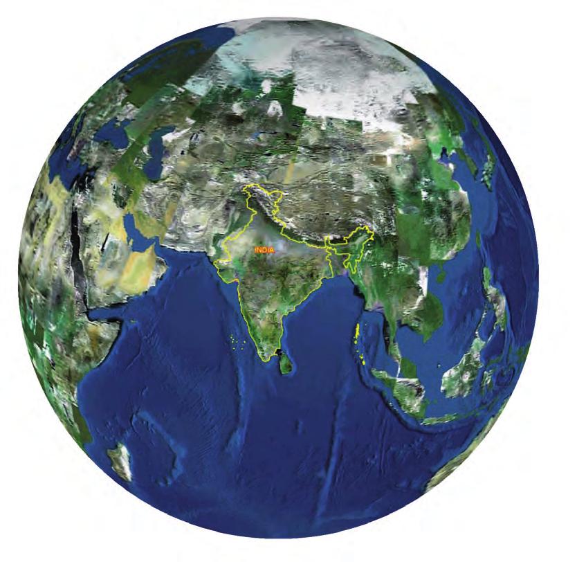


1 bhuvan ISRO s Geoportal Gateway to Indian Earth Observation Data Products & Services


 web services enabling interoperability")

 to browse and download satellite data and")
 capabilities through online rendering of")


2 One-stop versatile Web based Earth Observation Data Products & Services Interactive 3D Environment Societal Applications Thematic Vectors 3D Geographic Models Seamless Fly Throughs Bhuvan Gateway to Indian Earth Observation Explore, experience, visualise and analyse Indian Remote Sensing (IRS) images Rapid access to 3D geospatial data powered with real-time data sharing and colloboration providing a true Common Operating Picture Rich Thematic Datasets to visualise and consume as Open Multi Resolution Terrain Geospatial Consortium (OGC) web services enabling interoperability Visualise different layers explore Geoprocessing, and feel empowered with Bhuvan 2D having no dependencies Access to Bhuvan, the Earth Browser through smartphones NRSC Open EO Data Archive (NOEDA) to browse and download satellite data and products Vision To evince the distinctiveness of Indian Earth Observation(EO) capabilities through online rendering of multi-resolution, multi-temporal and multi-sensor IRS imagery overlaying value added thematic information on 2D/3D virtual globe, providing satellite data and products for download and consume thematic datasets as OGC web services towards online Geo-Processing, whilst serving for societal good

3 Know Bhuvan What is it? Bhuvan (means Earth in Sanskrit) is a Geoportal of ISRO, to evince the Indian Earth Observation capabilities from the Indian Remote Sensing (IRS) series of satellites. It is an interactive versatile Earth-Browser which showcases multi-sensor, mutli-platform and multitemporal images with capabilities to overlay thematic information, interpreted from such imagery as a vector layer, along with near real-time information from Automatic Weather Stations (AWS), Potential Fishing Zone (PFZ) information, disaster support related information like forest fire alerts, periodic agricultural drought assessment etc. What can it do? Ranging from visualisation, Bhuvanites can also download IRS data products and consume thematic datasets as OGC web services towards Geoprocessing. A Place where users can add their own points of interest and share them with others Can delineate vector features as shape files Can be connected to Global Positioning System(GPS) device in real-time or playback mode Users can chart routes, plot areas, view terrain profile and overlay images Useful for educators to teach subjects ranging from sciences to history. Also, take students virtually to an area being studied and show them the topography, surrounding areas etc. Useful for scientists to facilitate new possibilities from the IRS geospatial data for collaborative research Useful for administrators to monitor various developmental schemes at the grassroots level How does it work? It is a free web based visualisation system. Users can access Bhuvan by visiting Users can choose Bhuvan 2D or Bhuvan 3D for EO visualisation, Open EO data archive for downloading IRS satellite data and products, and thematic data dissemination for obtaining interoperable OGC web services Different supporting components like interactive videos, virtual tour, discussion forum, help documents are also available. Registration is optional in Bhuvan. However, some features require registration. Users can use the Central Authentication Service of Bhuvan for creating an account on Bhuvan towards single sign-on (SSO). Registered users are having privilege to share and download the data, collaborate with other Bhuvanites, discussions in Forum etc. A plug-in is to be downloaded and installed to access Bhuvan 3D (for first time use) Why is it significant? Scientists, academicians, policy makers and general public can leverage this integration of vast amounts of geospatial data in an easy-to-use multi-lingual interface without any additional resources The tool's visual immediacy could prove enormously beneficial, for example, for a survey of various geological structures in a region Individually, students can use Bhuvan to know and examine places they are studying. Also allows them to create and share personal resources like data sharing Bhuvan lets users to download specific satellite data and products, and also encourages users to revisit and explore availability of new datasets Where is it going? Bhuvan has become more sophisticated, with additional tools and increased coverage of high resolution imagery, free satellite data download and thematic data dissemination as web services By integrating with other existing applications, Bhuvan is poised to become a spatially based collection of profound information, coupled with facts and knowledge. Blogs, user groups, social networking sites and forums are enabled for users to share ideas and experiences, and post case studies also

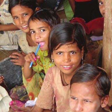
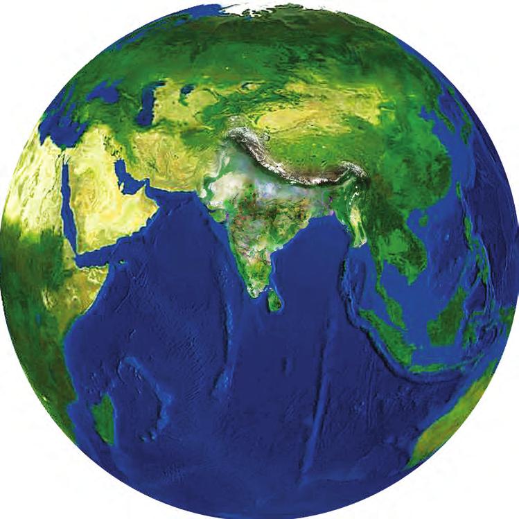
4 Bhuvan gives you an easy way to experience, explore, visualise & download IRS images ISRO is well known amongst space faring nations for its world-leading reputation in developing new, indigenous and innovative service oriented applications using remote sensing technology. Over the past 2 decades, ISRO has mastered the art of developing these unique applications using various spectral, spatial and temporal resolutions offered by the versatile IRS satellites and these have been successfully institutionalized in many important areas of policy making, natural resources management, disaster support, and enhancing the quality of life across all sections of the society. Bhuvan an initiative to showcase this distinctiveness of Indian imaging capabilities including the thematic information derived from such imagery is of vital importance to common man. Bhuvan an ambitious project of ISRO to take Indian images and thematic information in multiple spatial resolutions to people with a web portal through easy access to information on basic natural resources in the geospatial domain. Bhuvan showcases Indian images by the superimposition of the IRS satellite imageries on 2D/ 3D virtual globe. It displays satellite images of varying resolution of India's surface, allowing users to visually see things like cities and important places of interest looking perpendicularly down or at an oblique angle, with different perspectives and can navigate through 3D viewing environment. The degree of resolution showcased is based on the points of interest and popularity, but most of the Indian terrain is covered up to at least 6 metres of resolution with the least spatial resolution being 55 metres from AWiFS Sensor, while some cities are having 2.5 metres and 1 metre resolution. With such rich content, Bhuvan opens the door to net-centric visualisation of digital geospatial India allowing individuals to experience the fully interactive terrain viewing capabilities. Bhuvan 2D offers powerful, user-friendly mapping technology to organize the satellite and map data along with myriad information geographically with no dependencies in an easy way. It also offers Geoprocessing services, WMS manager, Embeddable HTML and SendLink options. Apart from visualisation, Bhuvan facilitates user to browse, select and download satellite data and products through NOEDA. Through Thematic Services it also facilitates to select, browse and query thematic datasets and consume as OGC web services. Bhuvan brings a whole lot of uniqueness in understanding our own natural resources whilst presenting beautiful images and thematic information generated from varieties of geospatial data. Bhuvan also attempts to bring out the importance of multitemporal data and to highlight the changes taking place to our natural resources, which will serve as a general awareness on our changing planet. There are lot more value added services which will be enabled onto this Geoportal due course of time and each one of those services are going to be unique to preserving and conserving our precious natural resources through public participation. Knowledge - Insight - Awareness - Action


5 Bhuvan 2D The two dimensional (2D) Bhuvan, a web mapping service application based on OpenLayers open source project, offers powerful, user-friendly mapping technology to organise the satellite data and map along with myriad information geographically with no server-side dependencies in an easy way. Bhuvan 2D is a slick, exciting online mapping application. It provides a highly responsive, intuitive mapping interface with detailed imagery and map data embedded. Some of its functional capabilities include map navigation, drawing point line, polygon, online shapefile creation, geoprocessing overview map, linear and areal measurement. These capabilities combine to make Bhuvan 2D a compelling product. Bhuvan 3D Pocket Bhuvan Bhuvan 3D showcases images in a multi-sensor, multi-platform and a multitemporal domain. It lets you access, explore and visualise IRS image and a bundle of rich thematic information in 3D landscape. On Bhuvan 3D, users can fly to different locations on the terrain and experience unparalleled 3D navigation. 3D Bhuvan has many unique features and easy to use intuitive interface, where users can virtually experience the physical characteristics of the terrain, especially the Indian landscape. The urban design tools are a magic galore. Here you can virtually build roads, junctions and traffic lights in an urban setting! Experience all this just on Bhuvan 3D! Access Earth Browser in your smart phone. Supported in devices based on Android, Windows, Symbian, ios and BlackBerry OS

, Tiles, Interactive Drawing. Users can see thumbnail view, metadata (NSDI 2.")

6 NOEDA NRSC Open EO Archive NRSC Open EO Data Archive facilitates the users to select, browse and download satellite data and products. Through NOEDA Bhuvan has laid a step forward in serving Scientific and Research community by providing free data download, At present Cartosat-1:DEM: 1 arc sec, Resourcesat- 1:AWiFS Ortho (2008,2009):56m, Resourcesat-1:LISS-III Ortho ( ):24m datasets for Indian region are available for download.and planned to extend for IRS satellite data courser than 24m in near future. It gives the option to select area based on 'Bounding Box, Mapsheet (SOI), Tiles, Interactive Drawing. Users can see thumbnail view, metadata (NSDI 2.0) and download the selected tiles Thematic Services Bhuvan-Thematic Services facilitate the users to select, browse and query the Thematic Datasets. Users can consume these Thematic Datasets and integrate into their systems as OGC web services. Presently Land Use and Land Cover (50K): datasets are available and planned to extend for other themes like land degradation, soil etc. It has the options of getting state and district wise statistics, Area Of Interest (AOI) based analysis, URL for WMS/WMTS services, view based print and adding external WMS layers

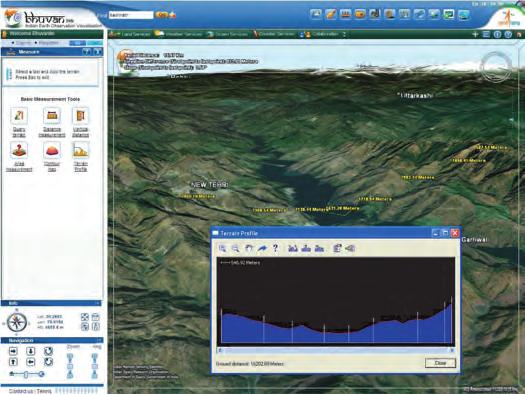
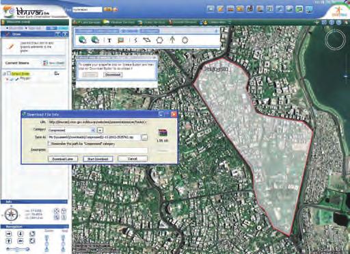
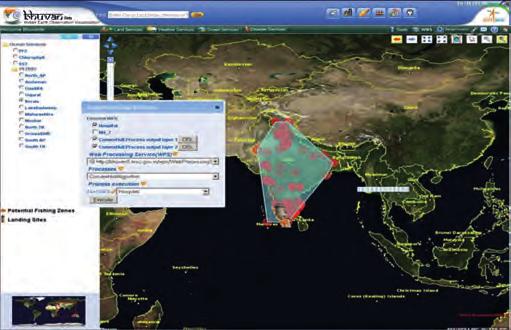
7 Snapshots of Bhuvan Functionalities Online Shapefile creation Terrain Profile Online Web Processing Service


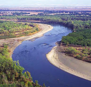
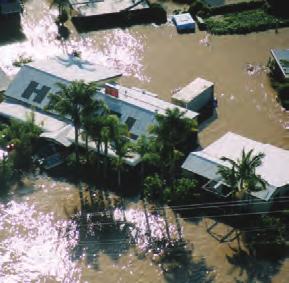
8 Snapshots of Bhuvan Services Near Real-time Weather Parameters Potential Fishing Zone Information Flood Inundated Area


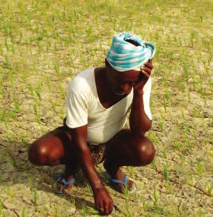
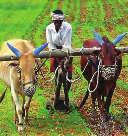
9 Bhuvan Applications Societal Ground Water Potential Zones Wasteland Information Soil Information
, Potential Fishing Zone (PFZ) information, disaster support related information like forest fire alerts, periodic agricultural drought")
 Draw tool")
10 Bhuvan Features Seamless visualization of multi-sensor, mutliplatform and multi-temporal images with capabilities to overlay thematic information soil, wasteland, water resources etc. Near real-time information from Automatic Weather Stations (AWS), Potential Fishing Zone (PFZ) information, disaster support related information like forest fire alerts, periodic agricultural drought assessment etc. Superpose administrative boundaries of choice on images. Categorisation of services Land, Weather, Ocean and Disaster services 3D fly through (3D view to fly to locations, objects in the terrain, and navigate freely using the mouse or keyboard) Draw tool with option of exporting the vector features (point/line/polygon) as shapefiles Add Layer (allows user to add external WMS, WFS, KML, georeferenced image, shapefile and share) Collaborate tool Add Content (allows user to add their volunteered geographic information and share with others) Free satellite data and products download OGC web services towards Interoperability Collaboration tool for community participation GIS Tools (Attribute Query, Buffer Analysis) & Online Geoprocessing GPS tool to connect Bhuvan with GPS devices in real time and playback mode Video On Terrain for surveillance activity Embeddable HTML and Send Bhuvan Link Multi-Lingual (English, Hindi, Tamil, Telugu and planned to extend in other Indian Languages) Other tools : Snapshot Measure tools, Shadow analysis, Urban Design tools, Navigation map, Terrain Profile tool, Contour maps Add Content tool


11 About NRSC National Remote Sensing Centre A key constituent of Indian Space Research Organisation (ISRO), Department of Space, Government of India, is at the heart of India's efforts to advance and benefit from the Indian Earth Observation Programme. NRSC strives to provide high quality, actionable data products and services in a timely, cost effective and efficient manner, facilitating enhanced utilization of remote sensing and geoinformation in addressing societal needs and national imperatives.

12 Stay Connected Get Our Newsletter Write to Become a Fan on Facebook Follow us on Twitter You Tube Watch Bhuvan Videos Bhuvan Cell National Remote Sensing Centre Indian Space Research Organisation Dept. of Space, Govt. of India Balanagar, Hyderabad Contact: bhuvan@nrsc.gov.in
Customer Showcase > Defense and Intelligence
 Customer Showcase Skyline TerraExplorer is a critical visualization technology broadly deployed in defense and intelligence, public safety and security, 3D geoportals, and urban planning markets. It fuses
Bhuvan Services and Applications
 Bhuvan Services and Applications http://bhuvan.nrsc.gov.in National Remote Sensing Centre Indian Space Research Organization Department of Space, Hyderabad BHUVAN Indian Geoplatform of ISRO Visualization
Lessons, challenges & innovations: Indian Case studies EO data research to use
 Lessons, challenges & innovations: Indian Case studies EO data research to use Vinay K Dadhwal Director Indian Institute of Space Science & Technology Scaling-up Innovations for Solution Enablement (Commercialisation
Integrated Data Handling and Visualization
 Integrated Data Handling and Visualization Module of Remote Sensing and GIS Integration Course 2017 Lammert Kooistra, Ron van Lammeren, John Stuiver Environmental Resource Management in the Anthropocene
Agency Report: Indian Earth Observation Programme
 Agency Report: Indian Earth Observation Programme Nitant Dube Space Applications Centre Indian Space Research Organisation Presentation to CEOS WGISS-41, Canberra Australia, March 2016 Indian EO Programme:
ISRO s EARTH OBSERVATION SYSTEM (updates from last Plenary) AS Kiran Kumar ISRO, INDIA
 AS Kiran Kumar ISRO, INDIA") ISRO s EARTH OBSERVATION SYSTEM (updates from last Plenary) AS Kiran Kumar ISRO, INDIA The 24 th CEOS Plenary Rio de Janeiro, Brazil 12-15 October, 2010 1 Four Decades of Indian Space Programme 30LV Missions
ISRO s EARTH OBSERVATION SYSTEM (updates from last Plenary) AS Kiran Kumar ISRO, INDIA The 24 th CEOS Plenary Rio de Janeiro, Brazil 12-15 October, 2010 1 Four Decades of Indian Space Programme 30LV Missions
- Avenues and Requisites for Successful Collaboration - Indian Space Research Organisation Department of Space Government of India
 Strengthening Regional Resilience with Geo-Information Programme on Trans-boundary Cooperation in South and South East Asia for geospatial information - Avenues and Requisites for Successful Collaboration
(updates from last Plenary) AS Kiran Kumar ISRO, INDIA
 AS Kiran Kumar ISRO, INDIA") ISRO s EARTH OBSERVATION SYSTEM (updates from last Plenary) AS Kiran Kumar ISRO, INDIA The 24 th CEOS Plenary Rio de Janeiro, Brazil 12 15 October, 2010 1 Four Decades of Indian Space Programme 30 LV Missions
ISRO s EARTH OBSERVATION SYSTEM (updates from last Plenary) AS Kiran Kumar ISRO, INDIA The 24 th CEOS Plenary Rio de Janeiro, Brazil 12 15 October, 2010 1 Four Decades of Indian Space Programme 30 LV Missions
The power of virtual globes for valorising cultural heritage and enabling sustainable tourism: NASA World Wind applications
 The power of virtual globes for valorising cultural heritage and enabling sustainable tourism: NASA World Wind applications Maria Antonia Brovelli*, Patrick Hogan**, Marco Minghini*, Giorgio Zamboni* *
Digital database creation of historical Remote Sensing Satellite data from Film Archives A case study
 Digital database creation of historical Remote Sensing Satellite data from Film Archives A case study N.Ganesh Kumar +, E.Venkateswarlu # Product Quality Control, Data Processing Area, NRSA, Hyderabad.
UNOSAT Satellite Imagery and GIS Solutions for DRR and Emergency Management
 UNOSAT Satellite Imagery and GIS Solutions for DRR and Emergency Management Francesco Pisano Director, Research, Technology Applications & Knowledge Systems January 2013 Introduction to UNOSAT 2 About
18 th January 2018 Hyderabad. Shishir Verma Sr. Vice President
 18 th January 2018 Hyderabad Shishir Verma Sr. Vice President MapmyIndia At a Glance FOUNDED EMPLOYEES CONSUMER BASE ENTERPRISE CLIENTS CERTIFICATION CMMI ML 3 1995 750+ 5,000,000+ 5000+ ISO 9001:2008
Arulraj.M Manager, Bhuvan Web Services Development
 http://bhuvan.nrsc.gov.in Arulraj.M Manager, Bhuvan Web Services Development BHUVAN FRAMEWORK BHUVAN DATA AS A SERVICE CONSUMING BHUVAN DATA USING OPENLAYERS API Customizing Bhuvan Framework BHUVAN TOOLS
Space Technology and its Applications for National Development. V Bhanumurthy Outstanding Scientist Scientist, Associate Director, NRSC/ISRO
 Space Technology and its Applications for National Development V Bhanumurthy Outstanding Scientist Scientist, Associate Director, NRSC/ISRO GEO4SDGs THEME: GEO-KNOWLEDGE CONDUIT TO SDGs SUCCESS Geospatial
GIS and Remote Sensing BIO8014. Data acquisition
 GIS and Remote Sensing BIO8014 Data acquisition Introduction Data can be manually created Data can be obtained from a wide range of providers both free and at cost Acquisition is key and must be accounted
A map says to you, 'Read me carefully, follow me closely, doubt me not.' It says, 'I am the Earth in the palm of your hand. Without me, you are alone
 A map says to you, 'Read me carefully, follow me closely, doubt me not.' It says, 'I am the Earth in the palm of your hand. Without me, you are alone and lost. Beryl Markham (West With the Night, 1946
Main topic of research: creation of tree line map. Scale: LANDSAT imagery (15-30 m spatial resolution)
") «Usage of geoportal information for mapping the northern forest line boundary» Mikhail Zimin NINA (Trondheim, Norway) Volkovo village, Zvenigorod (Moscow region), RUSSIA, 14-1717 April, 2009 Introduction
«Usage of geoportal information for mapping the northern forest line boundary» Mikhail Zimin NINA (Trondheim, Norway) Volkovo village, Zvenigorod (Moscow region), RUSSIA, 14-1717 April, 2009 Introduction
Building Java Apps with ArcGIS Runtime SDK
 Building Java Apps with ArcGIS Runtime SDK Vijay Gandhi, Elise Acheson, Eric Bader Demo Source code: https://github.com/esri/arcgis-runtime-samples-java/tree/master/devsummit-2014 Video Recording: http://video.esri.com
Our Quality Promise WHITE PAPER
 Our Quality Promise www.digitalglobe.com Corporate (U.S.) +1.303.684.4561 or +1.800.496.1225 London +44.20.8899.6801 Singapore +65.6389.4851 To ensure your success, we put quality at our core At DigitalGlobe,
ArcGIS Runtime SDK for Java: Building Applications. Eric
 ArcGIS Runtime SDK for Java: Building Applications Eric Bader @ECBader Agenda ArcGIS Runtime and the SDK for Java How to build / Functionality - Maps, Layers and Visualization - Geometry Engine - Routing
Open Standard based Visualization Infrastructure for 3D Geospatial Information
 X3D Earth Open Standard based Visualization Infrastructure for 3D Geospatial Information 13 January 2008 / Web3D Korea Forum 유병현 Byounghyun Yoo Web3D Consortium Fellow MOVES (Modeling, Virtual Environment
Hydraulics and Floodplain Modeling Managing HEC-RAS Cross Sections
 WMS 10.1 Tutorial Hydraulics and Floodplain Modeling Managing HEC-RAS Cross Sections Modify cross sections in an HEC-RAS model to use surveyed cross section data v. 10.1 Objectives Build a basic HEC-RAS
Analysis & Geoprocessing: Case Studies Problem Solving
 Analysis & Geoprocessing: Case Studies Problem Solving Shawn Marie Simpson Federal User Conference 2008 3 Overview Analysis & Geoprocessing Review What is it? How can I use it to answer questions? Case
GeoBase Raw Imagery Data Product Specifications. Edition
 GeoBase Raw Imagery 2005-2010 Data Product Specifications Edition 1.0 2009-10-01 Government of Canada Natural Resources Canada Centre for Topographic Information 2144 King Street West, suite 010 Sherbrooke,
AERIAL SURVEYS COMPANY PROFILE
 AERIAL SURVEYS COMPANY PROFILE Aerial Surveys, previously known as GeoSmart, is an innovative aerial photography and geospatial mapping service provider Our services enable customers to make better business
ROLE OF SATELLITE DATA APPLICATION IN CADASTRAL MAP AND DIGITIZATION OF LAND RECORDS DR.T. RAVISANKAR GROUP HEAD (LRUMG) RSAA/NRSC/ISRO /DOS HYDERABAD
 RSAA/NRSC/ISRO /DOS HYDERABAD") ROLE OF SATELLITE DATA APPLICATION IN CADASTRAL MAP AND DIGITIZATION OF LAND RECORDS DR.T. RAVISANKAR GROUP HEAD (LRUMG) RSAA/NRSC/ISRO /DOS HYDERABAD WORKSHOP on Best Practices under National Land Records
ROLE OF SATELLITE DATA APPLICATION IN CADASTRAL MAP AND DIGITIZATION OF LAND RECORDS DR.T. RAVISANKAR GROUP HEAD (LRUMG) RSAA/NRSC/ISRO /DOS HYDERABAD WORKSHOP on Best Practices under National Land Records
A COMPREHENSIVE DATABASE OF HIGH-QUALITY RESEARCH. natureindex.com. Track top papers Explore collaborations Compare research performance
 Track top papers Explore collaborations Compare research performance A COMPREHENSIVE DATABASE OF HIGH-QUALITY RESEARCH Compare research output across 165 countries Track research from 375,000+ articles
Comparative Study of Cartosat-DEM and SRTM-DEM on Elevation Data and Terrain Elements
 Cloud Publications International Journal of Advanced Remote Sensing and GIS 2015, Volume 4, Issue 1, pp. 1361-1366, Article ID Tech-480 ISSN 2320-0243 Research Article Open Access Comparative Study of
SkylineGlobe 6.5 Technology Overview
 SkylineGlobe 6.5 Technology Overview w w w. S k y l i n e G l o b e. c o m Contents SKYLINEGLOBE PRODUCTS... 4 SKYLINEGLOBE ENTERPRISE... 5 SKYLINEGLOBE ENTERPRISE BUNDLE COMPONENTS... 6 TERRABUILDER...
DISTINGUISHING URBAN BUILT-UP AND BARE SOIL FEATURES FROM LANDSAT 8 OLI IMAGERY USING DIFFERENT DEVELOPED BAND INDICES
 DISTINGUISHING URBAN BUILT-UP AND BARE SOIL FEATURES FROM LANDSAT 8 OLI IMAGERY USING DIFFERENT DEVELOPED BAND INDICES Mark Daryl C. Janiola (1), Jigg L. Pelayo (1), John Louis J. Gacad (1) (1) Central
Marine Earth Observation & Applications at University College Cork
 Marine Earth Observation & Applications at University College Cork Rory Scarrott, with input from Eimear Tuohy & Chiara Pratola 2 nd Irish Industry Space Day, Hibernian Club, Dublin, September 2 nd 2015
Using Web-based Tools for GIS-Friendly Satellite Imagery
 Using Web-based Tools for GIS-Friendly Satellite Imagery Lindsey Harriman SGT, Contractor to the USGS EROS Center, Sioux Falls, South Dakota **Work performed under USGS contract G10PC00044 U.S. Department
Using Freely Available. Remote Sensing to Create a More Powerful GIS
 Using Freely Available Government Data and Remote Sensing to Create a More Powerful GIS All rights reserved. ENVI, E3De, IAS, and IDL are trademarks of Exelis, Inc. All other marks are the property of
Final Examination Introduction to Remote Sensing. Time: 1.5 hrs Max. Marks: 50. Section-I (50 x 1 = 50 Marks)
") Final Examination Introduction to Remote Sensing Time: 1.5 hrs Max. Marks: 50 Note: Attempt all questions. Section-I (50 x 1 = 50 Marks) 1... is the technology of acquiring information about the Earth's
Final Examination Introduction to Remote Sensing Time: 1.5 hrs Max. Marks: 50 Note: Attempt all questions. Section-I (50 x 1 = 50 Marks) 1... is the technology of acquiring information about the Earth's
Geocoding DoubleCheck: A Unique Location Accuracy Assessment Tool for Parcel-level Geocoding
 Measuring, Modelling and Mapping our Dynamic Home Planet Geocoding DoubleCheck: A Unique Location Accuracy Assessment Tool for Parcel-level Geocoding Page 1 Geocoding is a process of converting an address
Data users and data producers interaction: the Web-COSI project experience
 ESS Modernisation Workshop 16-17 March 2016 Bucharest www.webcosi.eu Data users and data producers interaction: the Web-COSI project experience Donatella Fazio, Istat Head of Unit R&D Projects Web-COSI
Digital Image Processing - A Remote Sensing Perspective
 ISSN 2278 0211 (Online) Digital Image Processing - A Remote Sensing Perspective D.Sarala Department of Physics & Electronics St. Ann s College for Women, Mehdipatnam, Hyderabad, India Sunita Jacob Head,
Top 10 Things at Esri UC 2015 & ArcGIS Pro
 Top 10 Things at Esri UC 2015 & ArcGIS Pro Jim Tochterman, VP - Research & Development Who is BCS? Formed in 1998 in Aiken, SC Privately held and woman-owned Primary focus is GIS for Public Safety Esri
White paper brief IdahoView Imagery Services: LISA 1 Technical Report no. 1 Processing and Evaluation
 White paper brief IdahoView Imagery Services: LISA 1 Technical Report no. 1 Processing and Evaluation Keith T. Weber, GISP, GIS Director, Idaho State University, 921 S. 8th Ave., stop 8104, Pocatello,
United nation, Vienna, 9-13 February 2015
 United nation, Vienna, 9-13 February 2015 RUSSIAN FEDERAL SPACE AGENCY In the Russian Federation, the federal agency in charge of space activities is the Russian Federal Space Agency (Roscosmos) Earth
UNIGIS University of Salzburg. Module: ArcGIS for Server Lesson: Online Spatial analysis UNIGIS
 1 Upon the completion of this presentation you should be able to: Describe the geoprocessing service capabilities Define supported data types input and output of geoprocessing service Configure a geoprocessing
Remote Sensing in Daily Life. What Is Remote Sensing?
 Remote Sensing in Daily Life What Is Remote Sensing? First time term Remote Sensing was used by Ms Evelyn L Pruitt, a geographer of US in mid 1950s. Minimal definition (not very useful): remote sensing
APCAS/10/21 April 2010 ASIA AND PACIFIC COMMISSION ON AGRICULTURAL STATISTICS TWENTY-THIRD SESSION. Siem Reap, Cambodia, April 2010
 APCAS/10/21 April 2010 Agenda Item 8 ASIA AND PACIFIC COMMISSION ON AGRICULTURAL STATISTICS TWENTY-THIRD SESSION Siem Reap, Cambodia, 26-30 April 2010 The Use of Remote Sensing for Area Estimation by Robert
Scalable geospatial 3D client applications in X3D - Interactive, online and in real-time
 Scalable geospatial 3D client applications in X3D - Interactive, online and in real-time Dipl.Inform.Univ Peter Schickel CEO Bitmanagement Software Vice President Web3D Consortium, Mountain View, USA OGC/Web3D
2010 Census Mapping Evolution, Potentialities and Integration to the National Spatial Data Infrastructure
 2010 Census Mapping Evolution, Potentialities and Integration to the National Spatial Data Infrastructure Miriam Barbuda, MsC LATIN AMERICA GEOSPATIAL FORUM Brazil, Rio de Janeiro, 15-17August 2012 BRAZIL
WGISS-42 USGS Agency Report
 WGISS-42 USGS Agency Report U.S. Department of the Interior U.S. Geological Survey Kristi Kline USGS EROS Center Major Activities Landsat Archive/Distribution Changes Land Change Monitoring, Assessment,
High resolution satellite imagery a shared and collective data source
 High resolution satellite imagery a shared and collective data source Jean-Philippe Cantou IGN France EFGS forum - Helsinki 16-18 october 2018 1 / 25 ign.fr IGN duties Produce and update the large scale
Hydraulics and Floodplain Modeling Managing HEC-RAS Cross Sections
 v. 9.1 WMS 9.1 Tutorial Hydraulics and Floodplain Modeling Managing HEC-RAS Cross Sections Modify cross sections in an HEC-RAS model to use surveyed cross section data Objectives Build a basic HEC-RAS
University of Kota Kota
 University of Kota Kota Diploma in Remote Sensing and GIS SYLLABUS 2017 1 Diploma in Remote Sensing And GIS (DRSGIS) Exam.-2016-17 Title of the Course: Diploma in Remote Sensing And GIS Duration of the
9/12/2011. Training Course Remote Sensing Basic Theory & Image Processing Methods September 2011
 Training Course Remote Sensing Basic Theory & Image Processing Methods 19 23 September 2011 Popular Remote Sensing Sensors & their Selection Michiel Damen (September 2011) damen@itc.nl 1 Overview Low resolution
UN-GGIM Future Trends in Geospatial Information Management 1
 UNITED NATIONS SECRETARIAT ESA/STAT/AC.279/P5 Department of Economic and Social Affairs October 2013 Statistics Division English only United Nations Expert Group on the Integration of Statistical and Geospatial
HMA Architecture WG Meeting,
 www.dlr.de Chart 1 DLR Online Data Access Status D-SDA Geoservice Team, S. Kiemle 2012-02-15 DLR EO Online Data Access Status HMA Architecture WG Meeting, 2012-02-15 www.dlr.de Chart 2 DLR Online Data
GEOGRAPHIC MODELLING AND ANALYSIS
 GEOGRAPHIC MODELLING AND ANALYSIS I. INTRODUCTION A. Background Geographic Information System is organized within a GIS so as to optimize the convenience and efficiency with they can be used. To distinguish
DEVELOPING A CLOUD-BASED ONLINE GEOSPATIAL INFORMATION SHARING AND GEOPROCESSING PLATFORM TO FACILITATE COLLABORATIVE EDUCATION AND RESEARCH
 DEVELOPING A CLOUD-BASED ONLINE GEOSPATIAL INFORMATION SHARING AND GEOPROCESSING PLATFORM TO FACILITATE COLLABORATIVE EDUCATION AND RESEARCH Z. L. Yang a, *, J. Cao a, K. Hu a, Z. P. Gui b, H. Y. Wu a,
GeoSpatial Technologies and Web Applications
 GeoSpatial Technologies and Web Applications M. Arulraj Sci/Engr SF Manager, Bhuvan Web Services Development arulraj_m@nrsc.gov.in GIS Activities in Problem Solving Environment Empowering Human Activities
Managing Imagery and Raster Data. Peter Becker
 Managing Imagery and Raster Data Peter Becker ArcGIS is a Comprehensive Imagery Platform Empowering you to make informed decisions System of Engagement System of Insight Extract Information from Imagery
Extending GDAL/OGR and UMN MapServer
 Extending GDAL/OGR and UMN MapServer Maarten Plieger Nils de Reus Providing the building blocks for a geospatial infrastructure http://adaguc.knmi.nl/ This project is sponsored by Space for Geo-Information
HARRIS GEOSPATIAL MARKETPLACE. HarrisGeospatial.com
 HARRIS GEOSPATIAL MARKETPLACE HarrisGeospatial.com Satellite image of Washington, D.C. Image courtesy of DigitalGlobe GET IT ALL IN ONE PLACE Data for Any Project Map Products Vis/Sim Products Geospatial
SkylineGlobe 6 Technology Overview
 SkylineGlobe 6 Technology Overview w w w. S k y l i n e G l o b e. c o m Contents SKYLINEGLOBE PRODUCTS... 3 TERRAEXPLORER... 7 TERRAEXPLORER FAMILY... 7 TERRAEXPLORER PRODUCTS - MAIN FEATURES... 8 C2MP
Monitoring of Irrigation Projects using BHUVAN web Services NWA, Pune
 Monitoring of Irrigation Projects using BHUVAN web Services NWA, Pune 30th June,2014 2.1 Field Data The field data required is name of the canal, name of the parent canal, design offtake chainage, design
The Crowd4Sat Project: Augmenting Satellite Observations with Crowdsourcing
 The Crowd4Sat Project: Augmenting Satellite Observations with Crowdsourcing Dr. Suvodeep Mazumdar Department of Computer Science The University of Sheffield, UK s.mazumdar@sheffield.ac.uk In collaboration
Working with Elevation Services. Cody Benkelman
 Working with Elevation Services Cody Benkelman Outline ArcGIS Online World Elevation & 3D Elevation Cache for Pro What is included? - Data and Tools How can I use it? - Modes of use - Client Applications
CITI-SENSE project. c/o NILU Norwegian Institute for Air Research Postboks Kjeller NORWAY
 CITI-SENSE project c/o NILU Norwegian Institute for Air Research Postboks 100 2027 Kjeller NORWAY CITI-SENSE project Development of sensor-based Citizens' Observatory Community for improving quality of
NASA Missions and Products: Update. Garik Gutman, LCLUC Program Manager NASA Headquarters Washington, DC
 NASA Missions and Products: Update Garik Gutman, LCLUC Program Manager NASA Headquarters Washington, DC 1 JPSS-2 (NOAA) SLI-TBD Formulation in 2015 RBI OMPS-Limb [[TSIS-2]] [[TCTE]] Land Monitoring at
LAND SURFACE TEMPERATURE MONITORING THROUGH GIS TECHNOLOGY USING SATELLITE LANDSAT IMAGES
 Abstract LAND SURFACE TEMPERATURE MONITORING THROUGH GIS TECHNOLOGY USING SATELLITE LANDSAT IMAGES Aurelian Stelian HILA, Zoltán FERENCZ, Sorin Mihai CIMPEANU University of Agronomic Sciences and Veterinary
White paper brief IdahoView Imagery Services: LISA 1 Technical Report no. 2 Setup and Use Tutorial
 White paper brief IdahoView Imagery Services: LISA 1 Technical Report no. 2 Setup and Use Tutorial Keith T. Weber, GISP, GIS Director, Idaho State University, 921 S. 8th Ave., stop 8104, Pocatello, ID
(Refer Slide Time: 1:20)
") Introduction to Remote Sensing Dr. Arun K Saraf Department of Earth Sciences Indian Institute of Technology Roorkee Lecture 02 Development of Remote Sensing Technology & Advantages Hello! This is second
Introduction to Remote Sensing Dr. Arun K Saraf Department of Earth Sciences Indian Institute of Technology Roorkee Lecture 02 Development of Remote Sensing Technology & Advantages Hello! This is second
Lab Exercise #3 Introduction to the Digital Globe Google Earth Geo210 Rockland Community College Professor Paluzzi Due Date:
 Lab Exercise #3 Introduction to the Digital Globe Google Earth Geo210 Rockland Community College Professor Paluzzi Due Date: The Digital Globe: Google Earth 30 Points Purpose: This lab will introduce the
NRS 415 Remote Sensing of Environment
 NRS 415 Remote Sensing of Environment 1 High Oblique Perspective (Side) Low Oblique Perspective (Relief) 2 Aerial Perspective (See What s Hidden) An example of high spatial resolution true color remote
MAPS & ENHANCED CONTENT
 MAPS & ENHANCED Delivering high quality maps to enterprise, government, automotive and consumer markets MAPS & SUPERIOR HOW SEAMLESS COVERAGE IS COMMUNITY DRIVEN THE FRESHEST MAP The heart of location
REMOTE SENSING DATA PRODUCTS AND FORMATS
 UNIT 6 REMOTE SENSING DATA PRODUCTS AND FORMATS Data Types and Sources Structure 6.1 Introduction Objectives 6.2 What is a Data Product? 6.3 Index Numbers for Data Products 6.4 Types of Data Products Products
Chapter 1 Overview of imaging GIS
 Chapter 1 Overview of imaging GIS Imaging GIS, a term used in the medical imaging community (Wang 2012), is adopted here to describe a geographic information system (GIS) that displays, enhances, and facilitates
DIGITALGLOBE ATMOSPHERIC COMPENSATION
 See a better world. DIGITALGLOBE BEFORE ACOMP PROCESSING AFTER ACOMP PROCESSING Summary KOBE, JAPAN High-quality imagery gives you answers and confidence when you face critical problems. Guided by our
Assessment of Unmanned Aerial Vehicle for Management of Disaster Information
 Journal of the Korea Academia-Industrial cooperation Society Vol. 16, No. 1 pp. 697-702, 2015 http://dx.doi.org/10.5762/kais.2015.16.1.697 ISSN 1975-4701 / eissn 2288-4688 Assessment of Unmanned Aerial
GEOGRAPHIC INFORMATION SYSTEMS Lecture 22: Field Mapping with GPS
 GEOGRAPHIC INFORMATION SYSTEMS Lecture 22: Field Mapping with GPS GPS Receivers - there are many GPS receivers on the market today - some receivers are relatively inexpensive (recreational grade receivers)
DIFFERENTIAL APPROACH FOR MAP REVISION FROM NEW MULTI-RESOLUTION SATELLITE IMAGERY AND EXISTING TOPOGRAPHIC DATA
 DIFFERENTIAL APPROACH FOR MAP REVISION FROM NEW MULTI-RESOLUTION SATELLITE IMAGERY AND EXISTING TOPOGRAPHIC DATA Costas ARMENAKIS Centre for Topographic Information - Geomatics Canada 615 Booth Str., Ottawa,
Services Overview. Northeast Blueprint
 Services Overview 2D CAD Conversions Paper to CAD 2D CAD Conversions Construction Engineering / CAD Services Construction Markups Consultant Drawings Coordinated Drawings As -Builts Steel Structural Detailing
How to put the Image Services in the Living Atlas to Work in Your GIS. Charlie Frye, Chief Cartographer Esri, Redlands
 How to put the Image Services in the Living Atlas to Work in Your GIS Charlie Frye, Chief Cartographer Esri, Redlands Image Services in the Living Atlas of the World Let s have a look: https://livingatlas.arcgis.com
Govt. Engineering College Jhalawar Model Question Paper Subject- Remote Sensing & GIS
 Govt. Engineering College Jhalawar Model Question Paper Subject- Remote Sensing & GIS Time: Max. Marks: Q1. What is remote Sensing? Explain the basic components of a Remote Sensing system. Q2. What is
ORCHESTRA: Developing a Unified Open Architecture for Risk Management Applications
 The First International Symposium on Geo-Information for Disaster Management Delft - 23 rd March 2005 ORCHESTRA: Developing a Unified Open Architecture for Risk Management Applications David Caballero
Land cover change methods. Ned Horning
 Land cover change methods Ned Horning Version: 1.0 Creation Date: 2004-01-01 Revision Date: 2004-01-01 License: This document is licensed under a Creative Commons Attribution-Share Alike 3.0 Unported License.
Data Preparation. Warren Vick Europa Technologies Ltd.
 Data Preparation Warren Vick Europa Technologies Ltd. What s your poison? We use a variety of methods and technologies Straw poll Hand drawn Non-GIS software (whole process) Esri PB / MapInfo Open source
Croatian ideas on simplifying the CAP
 PAYING AGENCY IN AGRICULTURE, FISHERIES AND RURAL DEVELOPMENT Croatian ideas on simplifying the CAP Karlo Banović, Sector for OTS control 2017 IACS Workshop, Ghent 30.5.2017 Contents Current use new technologies
Active and Passive Microwave Remote Sensing
 Active and Passive Microwave Remote Sensing Passive remote sensing system record EMR that was reflected (e.g., blue, green, red, and near IR) or emitted (e.g., thermal IR) from the surface of the Earth.
Lesson 3: Working with Landsat Data
 Lesson 3: Working with Landsat Data Lesson Description The Landsat Program is the longest-running and most extensive collection of satellite imagery for Earth. These datasets are global in scale, continuously
USGS Welcome. 38 th CEOS Working Group on Calibration and Validation Plenary (WGCV-38)
") Landsat 5 USGS Welcome Prepared for 38 th CEOS Working Group on Calibration and Validation Plenary (WGCV-38) Presenter Tom Cecere International Liaison USGS Land Remote Sensing Program Elephant Butte Reservoir
Landsat 5 USGS Welcome Prepared for 38 th CEOS Working Group on Calibration and Validation Plenary (WGCV-38) Presenter Tom Cecere International Liaison USGS Land Remote Sensing Program Elephant Butte Reservoir
Project samples. our Vision. Digital Land Scale Model. digital scale model of the territory. contact :
 our Vision Simplify and automate the modelling of towns and countryside, make the digital model available to all professionals involved in project evaluation, development, and education to the population.
The first part of Module three, data and tools, presents some of the resources available on the internet to get images from the satellites presented
 The first part of Module three, data and tools, presents some of the resources available on the internet to get images from the satellites presented in the previous module and some uses of the images,
Web3D and X3D Overview
 Web3D and X3D Overview Web3D Consortium Anita Havele, Executive Director Anita.havele@web3d.org March 2015 Market Needs Highly integrated interactive 3D worlds Cities - Weather - building - Engineering
Automation at Depth: Ocean Infinity and seabed mapping using multiple AUVs
 Automation at Depth: Ocean Infinity and seabed mapping using multiple AUVs Ocean Infinity s seabed mapping campaign commenced in the summer of 2017. The Ocean Infinity team is made up of individuals from
Remote sensing in archaeology from optical to lidar. Krištof Oštir ModeLTER Scientific Research Centre of the Slovenian Academy of Sciences and Arts
 Remote sensing in archaeology from optical to lidar Krištof Oštir ModeLTER Scientific Research Centre of the Slovenian Academy of Sciences and Arts Introduction Optical remote sensing Systems Search for
Co-ReSyF RA lecture: Vessel detection and oil spill detection
 This project has received funding from the European Union s Horizon 2020 Research and Innovation Programme under grant agreement no 687289 Co-ReSyF RA lecture: Vessel detection and oil spill detection
Updating a National Spatial Data Infrastructure : How satellite imagery contributes in France?
 Updating a National Spatial Data Infrastructure : How satellite imagery contributes in France? Jean-Philippe Cantou IGN Espace Mapping Urban Areas from Space, ESA-Esrin 4-5 nov 2015 1 / 30 ign.fr IGN France
Dr. P Shanmugam. Associate Professor Department of Ocean Engineering Indian Institute of Technology (IIT) Madras INDIA
 Madras INDIA") Dr. P Shanmugam Associate Professor Department of Ocean Engineering Indian Institute of Technology (IIT) Madras INDIA Biography Ph.D (Remote Sensing and Image Processing for Coastal Studies) - Anna University,
Dr. P Shanmugam Associate Professor Department of Ocean Engineering Indian Institute of Technology (IIT) Madras INDIA Biography Ph.D (Remote Sensing and Image Processing for Coastal Studies) - Anna University,
Google Earth Workshop Version 5
 Google Earth Workshop Version 5 From the Mitchell Home Page (http://mitchell.needham.k12.ma.us) Technology > For Teachers > Prof Dev > Google Earth Getting to Know Google Earth Taken from Google Earth
Location Prediction Identification
 Robert J. Novak, Ph.D. Professor of Medicine Division of Infectious Diseases William C. Gorgas Center for Geographic Medicine University Alabama at Birmingham School of Medicine Location Prediction Identification
Land Cover Type Changes Related to. Oil and Natural Gas Drill Sites in a. Selected Area of Williams County, ND
 Land Cover Type Changes Related to Oil and Natural Gas Drill Sites in a Selected Area of Williams County, ND FR 3262/5262 Lab Section 2 By: Andrew Kernan Tyler Kaebisch Introduction: In recent years, there
DisasterHub. DisasterHub
 DisasterHub DisasterHub A mobile application for enabling crowd generated data fusion in Earth Observation disaster management Mr. Vassilis TSIRONIS (NOA) Mr. Themistocles HEREKAKIS (NOA) Mrs. Alexia TSOUNI
National Report of (Arab Republic of Egypt) **
 **") ADVANCE UNEDITED VERSION UNITED NATIONS E/CONF.103/9/Add.1 Economic and Social Affairs 9 July 2013 Tenth United Nations Regional Cartographic Conference for the Americas New York, 19-23, August 2013 Item
ADVANCE UNEDITED VERSION UNITED NATIONS E/CONF.103/9/Add.1 Economic and Social Affairs 9 July 2013 Tenth United Nations Regional Cartographic Conference for the Americas New York, 19-23, August 2013 Item
Q&A Earth-i Q&A Earth-i Observing the Earth Question: Can you provide an over view of Ear th-i s current capabilities and expertise?
 Q&A Earth-i Las Vegas. Photo courtesy of Earth-i Q&A Richard Blain: CEO, Earth-i Observing the Earth Earth-i is one of Europe s most prominent NewSpace companies supplying high resolution image data and