Lessons, challenges & innovations: Indian Case studies EO data research to use
|
|
|
- Daisy Carson
- 6 years ago
- Views:
Transcription
1 Lessons, challenges & innovations: Indian Case studies EO data research to use Vinay K Dadhwal Director Indian Institute of Space Science & Technology Scaling-up Innovations for Solution Enablement (Commercialisation of Research and Innovations) GEOSPATIAL WORLD FORUM 2017, January, Hyderabad
2 Geospatial technology Preamble As facilitator, integration of diverse source of data, provider of actionable products Importance of research & innovation Series of small innovations
3 Content & Context Original aim was to develop EO based national operational applications Geospatial technologies integrated due to need and for ensuring most current technologies are brought to use
4 Indian Case Studies Crop Forecasting Forest Fire Alerts Deforestation A century scale analysis to annual automated hotspots Carbon Pools : Forest Biomass & Soil OC/IC Web-GIS Platform for Governance, citizens Terrain work in progress

5 Crop Forecasting : Pre-harvest Crop statistics for 66 crops from village to nation EO has to meet accuracy, timeliness & cost challenges Generic Approach known, but has challenges EO Data-Pattern Recognition-Inventory-Yield-Production Forecast Challenges : Cloud Free Data, Optimal Acquisition, In-season ground truth, timely analysis Research : Sampling scheme, Multi-date Crop Discrimination, SAR for rice Took nearly 30 years of continuous research, operational forecast, user engagement & capacity building for acceptance Ministry of Agriculture established Mahalanobis National Crop Forecasting Center in New Delhi in 2012 Innovations continue for operational use agency (Field Data through mobile apps, Bhuvan web-gis, pre-processed data sets, GIS layers for stratification, crop cutting capture by mobiles
6 Forest Fire Alert System Indian forests fire prone, > 90% man made fires EO Data Active Fire Algorithm Forest Map overlay Use? Time is key driver limiting its use Historical evolution DMSP night lights MODIS Soumi NPP Upscaling and usage realised by NRT processing after data acquisition Automation of fire detection, forest overlay and transfor of location to webgis Automated SMS to user Overall process completion minutes
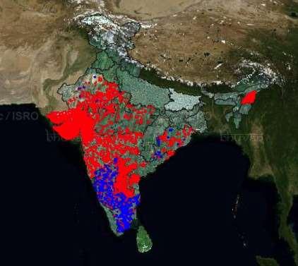
7 Monitoring Forest Cover Forest Departments have maintained forest statistics Legal definition of land utilization used (has own pitfalls) Forest Mapping by NRSA in 1980s showed lower tree cover Forest Survey of India, established and assigned task of biennial forest cover mapping Operational use of RS, but


8 Satellite Remote Sensing in Forestry and Environment Automated annual forest cover loss using IRS AWiFS data RS based spatial analysis for studying historical change Forest fire reporting: MODIS and NPP-Soumi. Multi-resolution satellite data have been used for biomass estimation In preparation for future missions, aerial and terrestrial LiDAR are being used to study three dimensional forest structure Forest Change in India Annual Forest Fire Locations National Forest Biomass using multi-resolution RS data Automated annual forest loss using IRS AWiFS TLS Scan


9 FOTO Forest Biomass: Cartosat-1, Yellapur Pargal, Fararoda, Rajasekar, Balachandran,Mechain, Barbier, Jha, Pelissier, Dadhwal, Couteron, 2016 Remote Sensing, (Under Review)
10 BHUVAN Evolution of National GIS Platform 2009 Initiated as public web access EO data visualization Challenges (i) Intercomparison, (ii) Niche, (iii) Usage, (iv) Response Step-wise annual updates for Free /open data download webgis/ OGC compliant WMS/WMTS of all national maps by NRSC Updating EO data content (resolution, location accuracy,...) Near real time disaster output sharing State / thematic mashups Platform for full applications Geo-tagging Mobile, multi-lingual Platform upgrade with distributed services...


11 BHUVAN is rich in Content & Services >> Scaling up Satellite Map Terrain 1 m Data Base & Thematic Data Open Data Satellite Data & Products Open Data Archive Bhuvan Applications S E R V I C E S Disaster Weather Ocean Crowd Sourcing Web Mobile Flood 3D Model Agriculture Urban e- Governance Irrigation Tourism + State Portals Land Use Waste Land Geomorphology / Lineament Salt effected water logging AIBP Urban Land Use 10K - NUIS Water Bodies and Floods Erosion

12 BHUVAN some quantification EO Data Hosted on Bhuvan - 3 Trillion pixels processed 1m HR Data lakhs Sq Km 2.5m Cartosat + MX - 17 lakh Sq km ( ) Additional 6.5 Lakh Sq Km Project specific 2.5 m data Locations/ Points of Interest - 10 million Bhuvan Web Applications Mobile applications - 54 Daily Unique Visitors : Sum in Month National Information System for Climate & Environment Studies Geophysical Products 58 (Available for download) OGC Compliant Map services Base for User Geospatial Data 22 Ministries Applications and 30 State portals online
![Use of BHUVAN in g/e-governance Geotagging of resources/ activities (leading to visualization [transparency], ciitizen use and planning)](/docs-images/73/69096203/images/13-1.jpg "Post Offices and postal Services Polling Booths (Andhra Basic Minimum Facilities) Housing for poor [ Health Facilities Village Assets")
13 Use of BHUVAN in g/e-governance Geotagging of resources/ activities (leading to visualization [transparency], ciitizen use and planning) Post Offices and postal Services Polling Booths (Andhra Basic Minimum Facilities) Housing for poor [ Health Facilities Village Assets (Amenities)
14 Information Systems for Governance Examples Railway Assets Information System (Min Railways) Toll Information System (NHAI) Postal Information System (Min Post & Telecom) Financial Information System (Min Finance) Airport Management System (Min Tourism/ AAI) Health Information System (Min Health & Ayush) School Information System (MHRD)


15 Background Bhuvan-GAIL: Gas Pipe Line Surveillance GAIL India Ltd. Maintains 15,000 Km Pipe line infrastructure for Gas Transportatin. Regular Surveillance of Pipeline is mandatory over pipeline Right of Usage (ROU). Objectives Develop Geospatial solution Near real-time Bhuvan Application for surveillance.. DATE OF PASS: 07 FEB 2014 Challenges Multi Satellite data coverage. Complimentary information Automatic in change analysis. Pilot implementation in progress ROAD SETTLEMENT


16 BHUVAN WebGIS Services - EO monitoring of Accelerated Irrigation Benefit Program (AIBP) Bhuvan AIBP Portal: Facilitates Visualization of Irrigation projects Datasets Available for Visualization: Monitoring the Canal progress on Bhuvan Salient Features: Canal Digitization: Facilitates digitization of Canal Networks with Calculation of total Canal Length, No. of gaps, Gaps Segments Length through help of Cartosat data. Add Content option for Remark Notification 3 levels of Access Control Data Editing facility for Field Data.
17 Geospatial Technology enabled Governance Use at all levels of Governance & most of departments Panchayat, Blocks, Municipalities, Districts/Basins, States, National Use in planning, project implementation & monitoring, citizen access & transparency, policy & compliance Urban Housing for all, Smart Cities Culture Protected Monuments, Management Zones Posts Locations, services, postman beat Petroleum Pipeline monitoring for right of usage Panchayati Raj - decentralised planning, panchayat assests Land Resources IWMP, Drinking Water, Sewerage Rural supply grids, disposal sites CWC Monitoring AIBP Railways Assets, Ticketing geo-fencing, Unmanned Crossings,...


18 National Level Watershed Monitoring (IWMP) Satellite images & Mobile tools Geotagging output
19 Future Directions Research for Operating in free/open mid-resolution EO data era Landsat, OLI, Sentinel +... Historical time series web-access/ API for server end processing Mobile devices with special sensors for field data colection
Bhuvan Services and Applications
 Bhuvan Services and Applications http://bhuvan.nrsc.gov.in National Remote Sensing Centre Indian Space Research Organization Department of Space, Hyderabad BHUVAN Indian Geoplatform of ISRO Visualization
bhuvan Gateway to Indian Earth Observation Data Products & Services ISRO s Geoportal
 bhuvan ISRO s Geoportal Gateway to Indian Earth Observation Data Products & Services One-stop versatile Web based Earth Observation Data Products & Services Interactive 3D Environment Societal Applications
Space Technology and its Applications for National Development. V Bhanumurthy Outstanding Scientist Scientist, Associate Director, NRSC/ISRO
 Space Technology and its Applications for National Development V Bhanumurthy Outstanding Scientist Scientist, Associate Director, NRSC/ISRO GEO4SDGs THEME: GEO-KNOWLEDGE CONDUIT TO SDGs SUCCESS Geospatial
Agency Report: Indian Earth Observation Programme
 Agency Report: Indian Earth Observation Programme Nitant Dube Space Applications Centre Indian Space Research Organisation Presentation to CEOS WGISS-41, Canberra Australia, March 2016 Indian EO Programme:
The use of satellite images to forecast agricultural
 The use of satellite images to forecast agricultural Luxembourg, 12.03.2014 r. Tomasz Milewski NUTS for Poland: NUTS 1 macro-regions (grup of province, voivodships) (6), NUTS 2 - regions (province,
NON-PHOTOGRAPHIC SYSTEMS: Multispectral Scanners Medium and coarse resolution sensor comparisons: Landsat, SPOT, AVHRR and MODIS
 NON-PHOTOGRAPHIC SYSTEMS: Multispectral Scanners Medium and coarse resolution sensor comparisons: Landsat, SPOT, AVHRR and MODIS CLASSIFICATION OF NONPHOTOGRAPHIC REMOTE SENSORS PASSIVE ACTIVE DIGITAL
APCAS/10/21 April 2010 ASIA AND PACIFIC COMMISSION ON AGRICULTURAL STATISTICS TWENTY-THIRD SESSION. Siem Reap, Cambodia, April 2010
 APCAS/10/21 April 2010 Agenda Item 8 ASIA AND PACIFIC COMMISSION ON AGRICULTURAL STATISTICS TWENTY-THIRD SESSION Siem Reap, Cambodia, 26-30 April 2010 The Use of Remote Sensing for Area Estimation by Robert
- Avenues and Requisites for Successful Collaboration - Indian Space Research Organisation Department of Space Government of India
 Strengthening Regional Resilience with Geo-Information Programme on Trans-boundary Cooperation in South and South East Asia for geospatial information - Avenues and Requisites for Successful Collaboration
ISRO s EARTH OBSERVATION SYSTEM (updates from last Plenary) AS Kiran Kumar ISRO, INDIA
 AS Kiran Kumar ISRO, INDIA") ISRO s EARTH OBSERVATION SYSTEM (updates from last Plenary) AS Kiran Kumar ISRO, INDIA The 24 th CEOS Plenary Rio de Janeiro, Brazil 12-15 October, 2010 1 Four Decades of Indian Space Programme 30LV Missions
ISRO s EARTH OBSERVATION SYSTEM (updates from last Plenary) AS Kiran Kumar ISRO, INDIA The 24 th CEOS Plenary Rio de Janeiro, Brazil 12-15 October, 2010 1 Four Decades of Indian Space Programme 30LV Missions
Customer Showcase > Defense and Intelligence
 Customer Showcase Skyline TerraExplorer is a critical visualization technology broadly deployed in defense and intelligence, public safety and security, 3D geoportals, and urban planning markets. It fuses
SUGAR_GIS. From a user perspective. Provides spatial distribution of a wide range of sugarcane production data in an easy to use and sensitive way.
 SUGAR_GIS From a user perspective What is Sugar_GIS? A web-based, decision support tool. Provides spatial distribution of a wide range of sugarcane production data in an easy to use and sensitive way.
United nation, Vienna, 9-13 February 2015
 United nation, Vienna, 9-13 February 2015 RUSSIAN FEDERAL SPACE AGENCY In the Russian Federation, the federal agency in charge of space activities is the Russian Federal Space Agency (Roscosmos) Earth
DisasterHub. DisasterHub
 DisasterHub DisasterHub A mobile application for enabling crowd generated data fusion in Earth Observation disaster management Mr. Vassilis TSIRONIS (NOA) Mr. Themistocles HEREKAKIS (NOA) Mrs. Alexia TSOUNI
NASA Missions and Products: Update. Garik Gutman, LCLUC Program Manager NASA Headquarters Washington, DC
 NASA Missions and Products: Update Garik Gutman, LCLUC Program Manager NASA Headquarters Washington, DC 1 JPSS-2 (NOAA) SLI-TBD Formulation in 2015 RBI OMPS-Limb [[TSIS-2]] [[TCTE]] Land Monitoring at
WGISS-42 USGS Agency Report
 WGISS-42 USGS Agency Report U.S. Department of the Interior U.S. Geological Survey Kristi Kline USGS EROS Center Major Activities Landsat Archive/Distribution Changes Land Change Monitoring, Assessment,
18 th January 2018 Hyderabad. Shishir Verma Sr. Vice President
 18 th January 2018 Hyderabad Shishir Verma Sr. Vice President MapmyIndia At a Glance FOUNDED EMPLOYEES CONSUMER BASE ENTERPRISE CLIENTS CERTIFICATION CMMI ML 3 1995 750+ 5,000,000+ 5000+ ISO 9001:2008
Introduction to Remote Sensing Fundamentals of Satellite Remote Sensing. Mads Olander Rasmussen
 Introduction to Remote Sensing Fundamentals of Satellite Remote Sensing Mads Olander Rasmussen (mora@dhi-gras.com) 01. Introduction to Remote Sensing DHI What is remote sensing? the art, science, and technology
Helicopter Aerial Laser Ranging
 Helicopter Aerial Laser Ranging Håkan Sterner TopEye AB P.O.Box 1017, SE-551 11 Jönköping, Sweden 1 Introduction Measuring distances with light has been used for terrestrial surveys since the fifties.
(updates from last Plenary) AS Kiran Kumar ISRO, INDIA
 AS Kiran Kumar ISRO, INDIA") ISRO s EARTH OBSERVATION SYSTEM (updates from last Plenary) AS Kiran Kumar ISRO, INDIA The 24 th CEOS Plenary Rio de Janeiro, Brazil 12 15 October, 2010 1 Four Decades of Indian Space Programme 30 LV Missions
ISRO s EARTH OBSERVATION SYSTEM (updates from last Plenary) AS Kiran Kumar ISRO, INDIA The 24 th CEOS Plenary Rio de Janeiro, Brazil 12 15 October, 2010 1 Four Decades of Indian Space Programme 30 LV Missions
Drafting Committee for the Asia Pacific Plan of Action for Space Applications for Sustainable Development ( ) Republic of Korea
 Republic of Korea") Drafting Committee for the Asia Pacific Plan of Action for Space Applications for Sustainable Development (2018 2030) Republic of Korea Bangkok, Thailand 31 May 1 June 2018 김 1 KARI Introduction Government
Drafting Committee for the Asia Pacific Plan of Action for Space Applications for Sustainable Development (2018 2030) Republic of Korea Bangkok, Thailand 31 May 1 June 2018 김 1 KARI Introduction Government
9/12/2011. Training Course Remote Sensing Basic Theory & Image Processing Methods September 2011
 Training Course Remote Sensing Basic Theory & Image Processing Methods 19 23 September 2011 Popular Remote Sensing Sensors & their Selection Michiel Damen (September 2011) damen@itc.nl 1 Overview Low resolution
Application and potentials of RADAR and LiDAR technologies for forest carbon assessment in Pacific Island Countries
 Application and potentials of RADAR and LiDAR technologies for forest carbon assessment in Pacific Island Countries June 19th, 2012 PNGFA-JICA Workshop Masamichi HARAGUCHI (Kokusai Kogyo Co., Ltd.) Consultant
UNISCAN AND ALICE-SC GROUND STATIONS AND DEVELOPMENT OF THEIR NETWORKS
 UNISCAN AND ALICE-SC GROUND STATIONS AND DEVELOPMENT OF THEIR NETWORKS Gershenzon V.E., Gershenzon O.N. R&D Center ScanEx Commission WG IV/9 KEY WORDS: Uniscan, Alice-SC, Stations, Geo-Portals ABSTRACT:
Can Satellite Image Analysis Replace Manual Digitization?
 Can Satellite Image Analysis Replace Manual Digitization? GeoDATA London 30 th Nov 2017 LUCY KENNEDY Spottitt CEO Lucy.Kennedy@spottitt.com +44 772 594 4643 Agenda Why develop processes and services based
Using Freely Available. Remote Sensing to Create a More Powerful GIS
 Using Freely Available Government Data and Remote Sensing to Create a More Powerful GIS All rights reserved. ENVI, E3De, IAS, and IDL are trademarks of Exelis, Inc. All other marks are the property of
FIRST BRAIN STORMING SESSION FOR SOUTHERN ENVIS CENTRES ENVIS CENTRE KERALA KERALA STATE COUNCIL FOR SCIENCE TECHNOLOGY AND ENVIRONMENT (KSCSTE)
") FIRST BRAIN STORMING SESSION FOR SOUTHERN ENVIS CENTRES ENVIS CENTRE KERALA KERALA STATE COUNCIL FOR SCIENCE TECHNOLOGY AND ENVIRONMENT (KSCSTE) Dr. Kamalakshan Kokkal Joint Director and ENVIS Coordinator
FIRST BRAIN STORMING SESSION FOR SOUTHERN ENVIS CENTRES ENVIS CENTRE KERALA KERALA STATE COUNCIL FOR SCIENCE TECHNOLOGY AND ENVIRONMENT (KSCSTE) Dr. Kamalakshan Kokkal Joint Director and ENVIS Coordinator
Radio Frequency Sensing from Space
 Radio Frequency Sensing from Space Edoardo Marelli ITU-R WP 7C Chairman ITU-R Seminar Manta (Ecuador) 20 September 2012 Why observing the Earth from space? Satellites orbiting around the Earth offer an
Satellite Remote Sensing: Earth System Observations
 Satellite Remote Sensing: Earth System Observations Land surface Water Atmosphere Climate Ecosystems 1 EOS (Earth Observing System) Develop an understanding of the total Earth system, and the effects of
PEGASUS : a future tool for providing near real-time high resolution data for disaster management. Lewyckyj Nicolas
 PEGASUS : a future tool for providing near real-time high resolution data for disaster management Lewyckyj Nicolas nicolas.lewyckyj@vito.be http://www.pegasus4europe.com Overview Vito in a nutshell GI
PILOTING A DECISION SUPPORT TOOL (DST) FOR MAPPING CYANOBACTERIAL HARMFUL ALGAL BLOOMS (CHABS) TO SUPPORT PUBLIC HEALTH AND RESOURCE MANAGEMENT.
 FOR MAPPING CYANOBACTERIAL HARMFUL ALGAL BLOOMS (CHABS) TO SUPPORT PUBLIC HEALTH AND RESOURCE MANAGEMENT.") PILOTING A DECISION SUPPORT TOOL (DST) FOR MAPPING CYANOBACTERIAL HARMFUL ALGAL BLOOMS (CHABS) TO SUPPORT PUBLIC HEALTH AND RESOURCE MANAGEMENT. Nathan Torbick, Applied Geosolutions Scott Stoodley, Director,
PILOTING A DECISION SUPPORT TOOL (DST) FOR MAPPING CYANOBACTERIAL HARMFUL ALGAL BLOOMS (CHABS) TO SUPPORT PUBLIC HEALTH AND RESOURCE MANAGEMENT. Nathan Torbick, Applied Geosolutions Scott Stoodley, Director,
Southern Africa Fire Network overview
 Southern Africa Fire Network overview - 2017 Estimation of live fuel moisture content Implementation of Dr Marta Yebra s FMC algorithm Currently running om MODIS MCD 43 c6 Applied on Sentinel 2 and
UNOSAT Satellite Imagery and GIS Solutions for DRR and Emergency Management
 UNOSAT Satellite Imagery and GIS Solutions for DRR and Emergency Management Francesco Pisano Director, Research, Technology Applications & Knowledge Systems January 2013 Introduction to UNOSAT 2 About
EARTH OBSERVATION WITH SMALL SATELLITES
 EARTH OBSERVATION WITH SMALL SATELLITES AT THE FUCHS-GRUPPE B. Penné, C. Tobehn, M. Kassebom, H. Lübberstedt OHB-System GmbH, Universitätsallee 27-29, D-28359 Bremen, Germany www.fuchs-gruppe.com ABSTRACT
Role of Landsat in Revolutionizing the Management of Natural Resources. Prof. UR Rao Former Chairman, ISRO, India
 Role of Landsat in Revolutionizing the Management of Natural Resources Prof. UR Rao Former Chairman, ISRO, India 40 Years of Landsat, June 6, 2012 Evolution of Remote Sensing Satellites TIROS Aerial Survey
DISTINGUISHING URBAN BUILT-UP AND BARE SOIL FEATURES FROM LANDSAT 8 OLI IMAGERY USING DIFFERENT DEVELOPED BAND INDICES
 DISTINGUISHING URBAN BUILT-UP AND BARE SOIL FEATURES FROM LANDSAT 8 OLI IMAGERY USING DIFFERENT DEVELOPED BAND INDICES Mark Daryl C. Janiola (1), Jigg L. Pelayo (1), John Louis J. Gacad (1) (1) Central
Remote Sensing in Daily Life. What Is Remote Sensing?
 Remote Sensing in Daily Life What Is Remote Sensing? First time term Remote Sensing was used by Ms Evelyn L Pruitt, a geographer of US in mid 1950s. Minimal definition (not very useful): remote sensing
REMOTE SENSING. Topic 10 Fundamentals of Digital Multispectral Remote Sensing MULTISPECTRAL SCANNERS MULTISPECTRAL SCANNERS
 REMOTE SENSING Topic 10 Fundamentals of Digital Multispectral Remote Sensing Chapter 5: Lillesand and Keifer Chapter 6: Avery and Berlin MULTISPECTRAL SCANNERS Record EMR in a number of discrete portions
Geocoding DoubleCheck: A Unique Location Accuracy Assessment Tool for Parcel-level Geocoding
 Measuring, Modelling and Mapping our Dynamic Home Planet Geocoding DoubleCheck: A Unique Location Accuracy Assessment Tool for Parcel-level Geocoding Page 1 Geocoding is a process of converting an address
IoT Market Perspective: India Market
 IoT Market Perspective: India Market IoT Week 2007, Geneva EU India Cooperation Platform in Future Internet & Electronic Media Project Abhishek Sharma, Beyond Evolution Tech Solutions (bets) Partners:
Ghazanfar A. Khattak National Centre of Excellence in Geology University of Peshawar
 INTRODUCTION TO REMOTE SENSING Ghazanfar A. Khattak National Centre of Excellence in Geology University of Peshawar WHAT IS REMOTE SENSING? Remote sensing is the science of acquiring information about
Digital database creation of historical Remote Sensing Satellite data from Film Archives A case study
 Digital database creation of historical Remote Sensing Satellite data from Film Archives A case study N.Ganesh Kumar +, E.Venkateswarlu # Product Quality Control, Data Processing Area, NRSA, Hyderabad.
Lesson 3: Working with Landsat Data
 Lesson 3: Working with Landsat Data Lesson Description The Landsat Program is the longest-running and most extensive collection of satellite imagery for Earth. These datasets are global in scale, continuously
Croatian ideas on simplifying the CAP
 PAYING AGENCY IN AGRICULTURE, FISHERIES AND RURAL DEVELOPMENT Croatian ideas on simplifying the CAP Karlo Banović, Sector for OTS control 2017 IACS Workshop, Ghent 30.5.2017 Contents Current use new technologies
PROJECT GRANTED UNDER INDO-EUROPEAN COOPERATION ON RENEWABLE ENERGY
 PROJECT GRANTED UNDER INDO-EUROPEAN COOPERATION ON RENEWABLE ENERGY FOWIND Project 12 th September 2014 Objective: Facilitate India s Transition Towards Low Carbon Development By Supporting Implementation
Separation of crop and vegetation based on Digital Image Processing
 Separation of crop and vegetation based on Digital Image Processing Mayank Singh Sakla 1, Palak Jain 2 1 M.TECH GEOMATICS student, CEPT UNIVERSITY 2 M.TECH GEOMATICS student, CEPT UNIVERSITY Word Limit
XSAT Ground Segment at CRISP
 XSAT Ground Segment at CRISP LIEW Soo Chin Head of Research, CRISP http://www.crisp.nus.edu.sg 5 th JPTM for Sentinel Asia Step-2, 14-16 Nov 2012, Daejeon, Korea Centre for Remote Imaging, Sensing and
ROLE OF SATELLITE DATA APPLICATION IN CADASTRAL MAP AND DIGITIZATION OF LAND RECORDS DR.T. RAVISANKAR GROUP HEAD (LRUMG) RSAA/NRSC/ISRO /DOS HYDERABAD
 RSAA/NRSC/ISRO /DOS HYDERABAD") ROLE OF SATELLITE DATA APPLICATION IN CADASTRAL MAP AND DIGITIZATION OF LAND RECORDS DR.T. RAVISANKAR GROUP HEAD (LRUMG) RSAA/NRSC/ISRO /DOS HYDERABAD WORKSHOP on Best Practices under National Land Records
ROLE OF SATELLITE DATA APPLICATION IN CADASTRAL MAP AND DIGITIZATION OF LAND RECORDS DR.T. RAVISANKAR GROUP HEAD (LRUMG) RSAA/NRSC/ISRO /DOS HYDERABAD WORKSHOP on Best Practices under National Land Records
RADAR (RAdio Detection And Ranging)
") RADAR (RAdio Detection And Ranging) CLASSIFICATION OF NONPHOTOGRAPHIC REMOTE SENSORS PASSIVE ACTIVE DIGITAL CAMERA THERMAL (e.g. TIMS) VIDEO CAMERA MULTI- SPECTRAL SCANNERS VISIBLE & NIR MICROWAVE Real
RADAR (RAdio Detection And Ranging) CLASSIFICATION OF NONPHOTOGRAPHIC REMOTE SENSORS PASSIVE ACTIVE DIGITAL CAMERA THERMAL (e.g. TIMS) VIDEO CAMERA MULTI- SPECTRAL SCANNERS VISIBLE & NIR MICROWAVE Real
Space Assets and the Sustainable Development Goals
 Space Assets and the Sustainable Development Goals Michael Simpson, Secure World Foundation In cooperation with Krystal Wilson Breakout Session #2 - Space Society Monday, November 21, 2016 United Nations/United
Sensor Technologies and Sensor Materials for Small Satellite Missions related to Disaster Management CANEUS Indo-US Cooperation
 Sensor Technologies and Sensor Materials for Small Satellite Missions related to Disaster Management CANEUS Indo-US Cooperation Suraj Rawal, Lockheed Martin Space Systems Co., USA G. Mohan Rao, Indian
BASICS OF REMOTE SENSING
 BASICS OF REMOTE SENSING 23: Basics of Remote Sensing Shibendu Shankar Ray Mahalanobis National Crop Forecast Centre, Department of Agriculture & Cooperation, Krishi Vistar Sadan, Pusa Campus, New Delhi
Warren Cartwright, Product Manager MDA Geospatial Services, Canada
 Advanced InSAR Techniques for Urban Infrastructure Monitoring Warren Cartwright, Product Manager MDA Geospatial Services, Canada www.mdacorporation.com RESTRICTION ON USE, PUBLICATION OR DISCLOSURE OF
Green/Blue Metrics Meeting June 20, 2017 Summary
 Short round table introductions of participants Paul Villenueve, Carleton, Co-lead Green/Blue, Matilda van den Bosch, UBC, Co-lead Green/Blue Dan Crouse, UNB Lorien Nesbitt, UBC Audrey Smargiassi, Uof
Preparing for the exploitation of Sentinel-2 data for agriculture monitoring. JACQUES Damien, DEFOURNY Pierre UCL-Geomatics Lab 2 octobre 2013
 Preparing for the exploitation of Sentinel-2 data for agriculture monitoring JACQUES Damien, DEFOURNY Pierre UCL-Geomatics Lab 2 octobre 2013 Agriculture monitoring, why? - Growing speculation on food
Earth Observations from Space U.S. Geological Survey
 Earth Observations from Space U.S. Geological Survey Geography Land Remote Sensing Program Dr. Bryant Cramer April 1, 2009 U.S. Department of the Interior U.S. Geological Survey USGS Landsat Historical
Lecture 13: Remotely Sensed Geospatial Data
 Lecture 13: Remotely Sensed Geospatial Data A. The Electromagnetic Spectrum: The electromagnetic spectrum (Figure 1) indicates the different forms of radiation (or simply stated light) emitted by nature.
Lecture 6: Multispectral Earth Resource Satellites. The University at Albany Fall 2018 Geography and Planning
 Lecture 6: Multispectral Earth Resource Satellites The University at Albany Fall 2018 Geography and Planning Outline SPOT program and other moderate resolution systems High resolution satellite systems
Landsat 8 and Sentinel 2 higher order products: input to S2DUP. Chris Justice (UMD) Curtis Woodcock (BU), Martin Claverie (UMD/GSFC)
 Curtis Woodcock (BU), Martin Claverie (UMD/GSFC)") Landsat 8 and Sentinel 2 higher order products: input to S2DUP Chris Justice (UMD) Curtis Woodcock (BU), Martin Claverie (UMD/GSFC) MODIS Land Products Energy Balance Product Suite Surface Reflectance
Landsat 8 and Sentinel 2 higher order products: input to S2DUP Chris Justice (UMD) Curtis Woodcock (BU), Martin Claverie (UMD/GSFC) MODIS Land Products Energy Balance Product Suite Surface Reflectance
Using Multi-spectral Imagery in MapInfo Pro Advanced
 Using Multi-spectral Imagery in MapInfo Pro Advanced MapInfo Pro Advanced Tom Probert, Global Product Manager MapInfo Pro Advanced: Intuitive interface for using multi-spectral / hyper-spectral imagery
Crop Area Estimation with Remote Sensing
 Boogta 25-28 November 2008 1 Crop Area Estimation with Remote Sensing Some considerations and experiences for the application to general agricultural statistics Javier.gallego@jrc.it Some history: MARS
2010 Census Mapping Evolution, Potentialities and Integration to the National Spatial Data Infrastructure
 2010 Census Mapping Evolution, Potentialities and Integration to the National Spatial Data Infrastructure Miriam Barbuda, MsC LATIN AMERICA GEOSPATIAL FORUM Brazil, Rio de Janeiro, 15-17August 2012 BRAZIL
NORMALIZING ASTER DATA USING MODIS PRODUCTS FOR LAND COVER CLASSIFICATION
 NORMALIZING ASTER DATA USING MODIS PRODUCTS FOR LAND COVER CLASSIFICATION F. Gao a, b, *, J. G. Masek a a Biospheric Sciences Branch, NASA Goddard Space Flight Center, Greenbelt, MD 20771, USA b Earth
Fires, Flares and Lights: Mapping Anthropogenic Emission Sources with Nighttime Low light Imaging Satellite Data
 Fires, Flares and Lights: Mapping Anthropogenic Emission Sources with Nighttime Low light Imaging Satellite Data Christopher D. Elvidge, Ph.D. Earth Observation Group NOAA National Geophysical Data Center
Data Requirements Definition and Data Services Options for RAPP
 Data Requirements Definition and Data Services Options for RAPP Brian Killough CEOS Systems Engineering Office (SEO) 5 th GEOGLAM RAPP Workshop Frascati, Italy May 16-17, 2017 Requirements Update The observation
Remote Sensing. The following figure is grey scale display of SPOT Panchromatic without stretching.
 Remote Sensing Objectives This unit will briefly explain display of remote sensing image, geometric correction, spatial enhancement, spectral enhancement and classification of remote sensing image. At
Monitoring Natural Disasters with Small Satellites Smart Satellite Based Geospatial System for Environmental Protection
 Monitoring Natural Disasters with Small Satellites Smart Satellite Based Geospatial System for Environmental Protection Krištof Oštir, Space-SI, Slovenia Contents Natural and technological disasters Current
NASA Earth Exchange (NEX)
") NASA Earth Exchange (NEX) Ramakrishna Nemani Ames Research Center NASA Advanced Supercomputing (NAS) Division Moffett Field, CA LCLUC Meeting, Yangon, January 15, 2016 OVERVIEW + NEX is virtual collaborative
NASA Earth Exchange (NEX) Ramakrishna Nemani Ames Research Center NASA Advanced Supercomputing (NAS) Division Moffett Field, CA LCLUC Meeting, Yangon, January 15, 2016 OVERVIEW + NEX is virtual collaborative
FUSION User Workshop
 FUSION User Workshop FUSION High Resolution Land Monitoring by Fusion of Optical and Infrared Data Normal temperature applications such as agricultural monitoring Lilit Kocharyan, RapidEye AG Gefördert
The Programmable City Smarter Cities. Tuesday, 9 May 2017
 The Programmable City Smarter Cities Tuesday, 9 May 2017 Welcome Muiris de Buitleir Agenda Welcome Muiris de Buitleir Data-driven urbanism and urban planning Dr Rob Kitchin Q&A Closing Remarks Muiris de
Remote Sensing Science and Sensors for Agricultural Applications
 Remote Sensing Science and Sensors for Agricultural Applications (Feb 20-24, 2018) Venue: Indian Institute of Technology Roorkee, Roorkee-247667, Uttarakhand, India Overview... In the era of smart agriculture,
VITO - Remote Sensing and Coastal Zone Management 18/02/ , VITO NV
 VITO - Remote Sensing and Coastal Zone Management 18/02/2016 1 VITO IN NUMBERS» 750 employees» 26 nationalities» More than 400 patents worldwide» HQ in Mol, België. Offices in Ostend, Berchem, Ghent, Genk»
Fundamentals of Remote Sensing
 Climate Variability, Hydrology, and Flooding Fundamentals of Remote Sensing May 19-22, 2015 GEO-Latin American & Caribbean Water Cycle Capacity Building Workshop Cartagena, Colombia 1 Objective To provide
Remote sensing radio applications/ systems for environmental monitoring
 Remote sensing radio applications/ systems for environmental monitoring Alexandre VASSILIEV ITU Radiocommunication Bureau phone: +41 22 7305924 e-mail: alexandre.vassiliev@itu.int 1 Source: European Space
NRS 415 Remote Sensing of Environment
 NRS 415 Remote Sensing of Environment 1 High Oblique Perspective (Side) Low Oblique Perspective (Relief) 2 Aerial Perspective (See What s Hidden) An example of high spatial resolution true color remote
Chapter 3 Data Acquisition in an Urban Environment
 Chapter 3 Data Acquisition in an Urban Environment - One fundamental issue : cost of data 5-10 times of HW, SW, org ware, staff training, maintenance - Another issue : different kinds of data alphanumeric
DOST- ASTI Initiatives on the Development of Monitoring Stations and Application of Satellite Technology in Philippine Agriculture
 DOST- ASTI Initiatives on the Development of Monitoring Stations and Application of Satellite Technology in Philippine Agriculture Alvin E. Retamar Chief Science Research Specialist Advanced Science and
Monitoring Land Use and Infrastructure Changes in Industrial Complex Using Geo-Informatics Technology in Gujarat State, India
 International Journal of Geosciences, 2016, 7, 1283-1298 http://www.scirp.org/journal/ijg ISSN Online: 2156-8367 ISSN Print: 2156-8359 Monitoring Land Use and Infrastructure Changes in Industrial Complex
Crowdsourcing for observations from satellites
 Crowdsourcing for observations from satellites Dr Stuart Wrigley Research Fellow Department of Computer Science The University of Sheffield, UK s.wrigley@sheffield.ac.uk @stuwrigley In collaboration with
Soil moisture retrieval using ALOS PALSAR
 Soil moisture retrieval using ALOS PALSAR T. J. Jackson, R. Bindlish and M. Cosh USDA ARS Hydrology and Remote Sensing Lab, Beltsville, MD J. Shi University of California Santa Barbara, CA November 6,
Newsletter. Spring 2016 "YOUR HEALTH SAFEGUARD"
 "YOUR HEALTH SAFEGUARD" Newsletter Spring 2016 A complete IoT (Internet of Things) and M2M life supporting platform, DoctorCloud is the new way of helping people in need to get in touch using the emerging
CLASSIFICATION OF VEGETATION AREA FROM SATELLITE IMAGES USING IMAGE PROCESSING TECHNIQUES ABSTRACT
 CLASSIFICATION OF VEGETATION AREA FROM SATELLITE IMAGES USING IMAGE PROCESSING TECHNIQUES Arpita Pandya Research Scholar, Computer Science, Rai University, Ahmedabad Dr. Priya R. Swaminarayan Professor
23/04/2018. Global Outlook Spatial Information Industry. Graeme Kernich, CEO CRCSI
 Global Outlook 2018 Spatial Information Industry Graeme Kernich, CEO CRCSI 1 Global Outlook 2018 Spatial Information Industry 2 Global Outlook 2018: Overview 3 Source: World Economic Forum, The Global
SECOND OPEN SKIES REVIEW CONFERENCE (OSRC) 2010
 2010") OSCC.RC/40/10 9 June 2010 Open Skies Consultative Commission ENGLISH only US Chair of the OSCC Review Conference SECOND OPEN SKIES REVIEW CONFERENCE (OSRC) 2010 7 to 9 June 2010 Working Session 2 Exploring
OSCC.RC/40/10 9 June 2010 Open Skies Consultative Commission ENGLISH only US Chair of the OSCC Review Conference SECOND OPEN SKIES REVIEW CONFERENCE (OSRC) 2010 7 to 9 June 2010 Working Session 2 Exploring
GROßFLÄCHIGE UND HOCHFREQUENTE BEOBACHTUNG VON AGRARFLÄCHEN DURCH OPTISCHE SATELLITEN (RAPIDEYE, LANDSAT 8, SENTINEL-2)
") GROßFLÄCHIGE UND HOCHFREQUENTE BEOBACHTUNG VON AGRARFLÄCHEN DURCH OPTISCHE SATELLITEN (RAPIDEYE, LANDSAT 8, SENTINEL-2) Karsten Frotscher Produktmanager Landwirtschaft Slide 1 A Couple Of Words About The
GROßFLÄCHIGE UND HOCHFREQUENTE BEOBACHTUNG VON AGRARFLÄCHEN DURCH OPTISCHE SATELLITEN (RAPIDEYE, LANDSAT 8, SENTINEL-2) Karsten Frotscher Produktmanager Landwirtschaft Slide 1 A Couple Of Words About The
How to Access Imagery and Carry Out Remote Sensing Analysis Using Landsat Data in a Browser
 How to Access Imagery and Carry Out Remote Sensing Analysis Using Landsat Data in a Browser Including Introduction to Remote Sensing Concepts Based on: igett Remote Sensing Concept Modules and GeoTech
DEPLOYING SPACE SCIENCE AND TECHNOLOGY FOR NATIONAL DEVELOPMENT Prof.R.A. Boroffice, OON TABLE OF CONTENTS
 DEPLOYING SPACE SCIENCE AND TECHNOLOGY FOR NATIONAL DEVELOPMENT Prof.R.A. Boroffice, OON TABLE OF CONTENTS 3.1 Introduction 3.2 Space as a Platform for Development 3.2.1 Vision 2020 and Space Technology
Monitoring of Irrigation Projects using BHUVAN web Services NWA, Pune
 Monitoring of Irrigation Projects using BHUVAN web Services NWA, Pune 30th June,2014 2.1 Field Data The field data required is name of the canal, name of the parent canal, design offtake chainage, design
AERIAL SURVEYS COMPANY PROFILE
 AERIAL SURVEYS COMPANY PROFILE Aerial Surveys, previously known as GeoSmart, is an innovative aerial photography and geospatial mapping service provider Our services enable customers to make better business
Smart Cities Solutions for Disaster Management Based on Satellites and Wireless Sensor Networks
 Smart Cities Solutions for Disaster Management Based on Satellites and Wireless Sensor Networks Presented by Dr. Krishna Dev Kumar Professor of Aerospace Engineering Director, Artificial Intelligence and
SDCG-5 Session 2. Landsat 7/8 status and 2013 Implementation Plan (Element 1)
") Session 2 Landsat 7/8 status and 2013 Implementation Plan (Element 1) Gene Fosnight Mission Landsat Launch and commissioning Landsat 7 Operational: since 15 April 1999 Expected life time:; anticipate decommissioning
Session 2 Landsat 7/8 status and 2013 Implementation Plan (Element 1) Gene Fosnight Mission Landsat Launch and commissioning Landsat 7 Operational: since 15 April 1999 Expected life time:; anticipate decommissioning
Flood modelling and management. Glasgow University. 8 September Paul Shaw - GeoVision
 Flood modelling and management Glasgow University 8 September 2004 Paul Shaw - GeoVision How important are heights in flood modelling? Comparison of data collection technologies GPS - Global Positioning
Application of Satellite Remote Sensing for Natural Disasters Observation
 Application of Satellite Remote Sensing for Natural Disasters Observation Prof. Krištof Oštir, Ph.D. University of Ljubljana Faculty of Civil and Geodetic Engineering Outline Earth observation current
The Study on the Application of the Intelligent Technology in the Sightseeing Agricultural Parks
 Abstract The Study on the Application of the Intelligent Technology in the Sightseeing Agricultural Parks Lei Feng, Jie Zhao Department of Architecture, Henan Technical College of Construction, Zhengzhou
A c c e s s t o C o p e r n i c u s D a t a
 A c c e s s t o C o p e r n i c u s D a t a Overview and Introduction Copernicus EU Copernicus EU Copernicus EU www.copernicus.eu C O P E R N I C U S I N B R I E F Copernicus Copernicus, a flagship programme
Accessing NASA Earth Science Data / Open Data Policy
 Accessing NASA Earth Science Data / Open Data Policy Presentation by Martha Maiden Program Executive Earth Science Data Systems NASA Headquarters martha.e.maiden@nasa.gov July 15, 2013 U.S. data policy
CALL359 JAPAN S EARTHQUAKE 2011, MARCH, 11
 CALL359 JAPAN S EARTHQUAKE 2011, MARCH, 11 PM for International Charter Dr. Masahiko Nagai JAXA - AIT 25th Meeting of the International Charter May 12 th 2011 on 2011, March, 11 at 14:46 (JST) Iwate Pref.
Remote Sensing Part 3 Examples & Applications
 Remote Sensing Part 3 Examples & Applications Review: Spectral Signatures Review: Spectral Resolution Review: Computer Display of Remote Sensing Images Individual bands of satellite data are mapped to
Image interpretation. Aliens create Indian Head with an ipod? Badlands Guardian (CBC) This feature can be found 300 KMs SE of Calgary.
 This feature can be found 300 KMs SE of Calgary.") Image interpretation Aliens create Indian Head with an ipod? Badlands Guardian (CBC) This feature can be found 300 KMs SE of Calgary. 50 1 N 110 7 W Milestones in the History of Remote Sensing 19 th century
Image interpretation Aliens create Indian Head with an ipod? Badlands Guardian (CBC) This feature can be found 300 KMs SE of Calgary. 50 1 N 110 7 W Milestones in the History of Remote Sensing 19 th century
Satellite data processing and analysis: Examples and practical considerations
 Satellite data processing and analysis: Examples and practical considerations Dániel Kristóf Ottó Petrik, Róbert Pataki, András Kolesár International LCLUC Regional Science Meeting in Central Europe Sopron,
Speech during the 12 th Esri Eastern Africa Users Conference at the Hyatt Regency, Dar es Salaam, Tanzania
 Speech during the 12 th Esri Eastern Africa Users Conference at the Hyatt Regency, Dar es Salaam, Tanzania By Dr. Eng. Maria Sasabo(PhD), Permanent Secretary, for Communication Sector, Ministry of Works,