GLMTF November 18, 2014 Presentation
|
|
|
- Alice Townsend
- 5 years ago
- Views:
Transcription
1 GLMTF November 18, 2014 Presentation
2 Michigan Security Network Founded by major corporations, industry leaders and leading universities in 2008 as a non-profit organization (501c6). MiSN mission is to identify, test and commercialize new technologies that can enhance trade and provide economic growth opportunities for Michigan and the Great Lakes Region. Projects leverage Michigan s leadership in R&D investment, world class science and engineering talent; leading research universities; technologically advanced supply chain; and highly skilled workforce.
3 Michigan Security Network MiSN serves in the role of general contractor by developing a coalition with key skill sets and technologies to test and advance new technologies. Comprehensive in-depth analysis of market segments that utilize Michigan s competitive advantages: BORDER/MARITIME TECHNOLOGY CYBERSECURITY BIODEFENSE (CBRN)
4 MiSN & Survice Engineering 2014 Analysis of ARGUS technology. Great Lakes application & commercial benefit. Potential to expand commerce on the Great Lakes. Also supports GLMTF dredging priority.
5 MiSN & GLMTF Industry input MiSN managing Test Phases & performance evaluation ARGUS technical discussion

6 Use of Crowd Source Bathymetry (CSB) in the Great Lakes Patented Crowd Source Technology* * US Patent 8,417,451 B2, Autonomous Cooperative Surveying
7 Presentation Overview About SURVICE Engineering Maritime need for real-time hydrography How does ARGUS work? Results ARGUS in the news Implementing an ARGUS Trusted Partner Network


8 About SURVICE ARGUS was developed by the SURVICE Engineering Company to address NOAA s mission needs for real time hydrographic surveying. SmartCEO Magazine Voltage Award for Technology Innovation SURVICE is an 30+ year old engineering consulting firm with over 350 employees with a broad spectrum of technical expertise in engineering, physics, mathematics, chemistry, and computer science supporting a wide-range of government and industry clientele. With decades of experience in research and development, and specialized design engineering applications, SURVICE has developed a number of high tech solutions for it s customers.


9 Maritime Need for Real-Time Hydrography Athos I, 2004 U.S. coastal waters have never been completely surveyed. In areas that have been surveyed, approximately 50% of soundings shown on NOAA nautical charts is based on pre-1940 data, collected by lead line soundings and wire drags. Vessel groundings have financial impacts, but also impact the environment, and in some cases lives. Accurate and real-time charts are essential to shipping. USS Guardian, 2013
 Autonomously records GPS position, water depth, water temperature Automatically offloads using secure extended-range marine")
10 How Does ARGUS Work? Onboard ARGUS unit plugs into vessel chartplotter (or ECS and echosounder) Autonomously records GPS position, water depth, water temperature Automatically offloads using secure extended-range marine WiFi, cellular, satellite User Control over how data is used No crew interaction required Completely autonomous recording and reporting of data Continuous bathymetry updates result from routine vessel activity

11 Opportunity for Better Hydro Data ARGUS is a self-enabling technology for the maritime industry Millions of commercial and recreational vessels operate in U.S. coastal and inland waterways Every vessel can provide valuable situational awareness for all of the vessels that follow it Participation improves the quality of the results as well as lowers the per vessel processing costs High resolution surveying can be better prioritized and directed


12 The Power of the Crowd in Baltimore Baltimore Pilot Study 3 vessels 10 months 14 million soundings 100,000 grid solutions 10 square kilometers


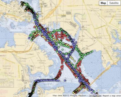
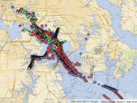
13 The Crowd Baltimore Solution Set Chart Comparison/Shoaling Identified


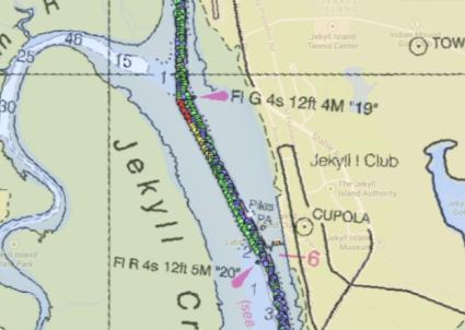
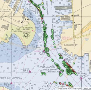
14 More Examples Nassau, Bahamas Fire Island Inlet Jersey Shore Uncharted Tuckerton, NJ Antarctica Intracoastal Waterway


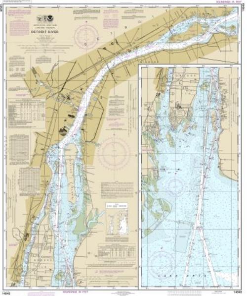
15 Typical Great Lakes Charts Detroit River
 quality")
 been surveyed, as well as providing continuous, ongoing monitoring for highly travelled areas.")
16 How Good is the Data? US Hydro 2013 Maxim van Norden, the University of Southern Mississippi Paul Cooper, CARIS USA John Hersey, the SURVICE Engineering Company CSB provides IHO Order 2 (and approaches Order 1b) quality for soundings. THU Typical GPS receiver has a positioning uncertainty of ±10 m at 95% confidence. TVU Multiple observations in the same locale provide reliable TVU under 1 m. Report Conclusions CSB is providing new information for remote waterways that have not (or not recently) been surveyed, as well as providing continuous, ongoing monitoring for highly travelled areas. At a fraction of traditional hydrographic surveying costs, CSB has the potential to contribute to improved safety and limited environmental risk. Combined with a constant supply of data from an unlimited crowdsourcing workforce, the steady improvement of sensing system capabilities, the evolving ARGUS CS-BDB solution sets will continuously approach <higher> IHO standards.


17 Dated, High Precision Multibeam vs. Current, Continuous Single Beam
18 Water Level (ft) Water Level (ft) More than just Depth Data Millions of soundings from stationary vessels enhances tide station data Float data not only provides depth measurements, but also contributes to tide corrections Float data snippets range from minutes to consecutive days, weeks Typical Water Levels, Charleston, SC NOAA Tide Station vs. ARGUS Vessel located 2 miles west, across Charleston peninsula Datum: MLLW Nearest NOAA Tide Station (15 miles south) ARGUS (Bush River) Tropical Storm Nicole /1/10 18:00 11/2/10 6:00 11/2/10 18:00 Date/Time (UTC) NOAA ARGUS Enhancement to existing tide-station networks 0-1 9/28/10 12:00 9/29/10 0:00 9/29/10 12:00 9/30/10 0:00 9/30/10 12:00 10/1/10 0:00 10/1/10 12:00 10/2/10 0:00 10/2/10 12:00 10/3/10 0:00 10/3/10 12:00 Date/Time (UTC)


19 In the News the only system that gathers data autonomously and with scientific controls PassageMaker, January 2012 one of the more interesting and valuable uses of social media that has evolved over the last few years Marine News, December 2011 the boating masses will change the way nautical knowledge is gathered and shared. No one on the water needs to be told about the GPS revolution of the past decade, but the most dramatic change has just begun. Motor Boating, April 2011 a system that may change the way depth and other data is gathered and distributed. Yachting, December 2009

20 Implementing a Trusted Partner Network Install ARGUS units on sufficient number of vessels that regularly transit area Includes extended range WiFi hardware Supports multiple sensor input channels Works with virtually all navigation systems/chart plotters Trusted Partner vessels are identified and surveyed such that GPS location and depth sensors are well known/established Known offsets help produce higher-quality data Additional vessels (commercial, government, and private) that have ARGUS units can add to data volume and quality
21 MiSN Next Steps Phase I Testing: Late March 2015 Evaluation & Analysis Technical Partner, Roush Industries

22 About Roush Industries

23 Roush Diversity
24 Roush s Role Technical Program Management Technical Interface with Shipping Companies Local Support for ARGUS Installations
25 Conclusion Phase I Execution Technical Input & Feedback Analysis & Evaluation Future Program Expansion
26 Thank You
LT Matthew Forney, NOAA Navigation Manager Alaska Region Bering Strait MaritimeSymposium. Office of Coast Survey
 NOAA LT Matthew Forney, NOAA Navigation Manager Alaska Region Bering Strait MaritimeSymposium Who is Coast Survey? First science agency of the U.S. Formed in 1807 Responsible for surveying 3.4 million
NOAA s National Ocean Service / Office of Coast Survey
 Coast Survey OCS 1807 2007 Maintains over 1000 nautical charts & 9 Coast Pilots Surveys over 3.4M SNM of oceans and lakes Conducts research and development in hydrography Thomas Jefferson Founder of The
Steps Towards a True Crowd, Collecting Bathymetry via Electronic Navigation Systems
 Steps Towards a True Crowd, Collecting Bathymetry via Electronic Navigation Systems Authors Adam Reed, LT/NOAA. Assistant Coordinator, Integrated Oceans and Coastal Mapping, NOAA. adam.reed@noaa.gov NOAA
EGYPTIAN HYDROGRAPHIC DEPARTMENT THE EGYPTIAN HYDROGRAPHIC FRAMEWORK
 gvt THE EGYPTIAN HYDROGRAPHIC FRAMEWORK The roles of a national Hydrographic Service can be summarized in collecting georeferenced data through systematic surveys at sea and along the coast related to:
INGESTION OF JALBTCX ALB DATASET INTO NOAA'S CHART PRODUCTION
 INGESTION OF JALBTCX ALB DATASET INTO NOAA'S CHART PRODUCTION Shachak Pe eri (JHC/CCOM) and Gretchen Imahori (NOAA) OCS/MCD (NOAA): John Barber, Anthony Klemm, Julia Powell, Mike Brown and John Nyberg
The ship RV Timba repairs are now almost complete and it is expected that come September 2014 the ship will be fully operational.
 Malawi National Report 2014 1 Malawi Hydrographic Office The assembly of the 70 ton ship RV Timba with the assistance of the French government in 1989 ushered in the commencement of modern hydrographic
COOK INLET NAVIGATION CHANNEL
 COOK INLET NAVIGATION CHANNEL 1-5 COOK INLET NAVIGATION CHANNEL, ALASKA (CWIS NO. 10324, 10534) Condition of Improvement 30 September 2011 AUTHORIZATION: (1) Water Resources Development Act of 1996 (Public
Future of ocean mapping, hydrography, policy and public perception
 Future of ocean mapping, hydrography, policy and public perception Mustafa IPTES Director, IHO Busan, 15 November 2017 OUTLINE Current status of Ocean Mapping Ongoing Ocean Mapping Activities New Initiatives
A guideline for establishing feature and symbol standard management system for national HOs
 A guideline for establishing feature and symbol standard management system for national HOs Joint 26th TSMAD and 5th DIPWG Meeting Silver Spring, Maryland, USA(10-14 June 2013) Republic of Korea (ROK)
There is also need to acquire equipment such as GPS, Echo-Sounder and update data acquisition and processing software among other requirements.
 Malawi National Report 2016 1 Malawi Hydrographic Office The mandate of the Hydrographic office is to carry out surveys of Lake Malawi including the lesser lakes of Malombe, Chilwa and Chiuta as well as
Recent Developments in NOAA s Real- Time Coastal Observing Systems for Safe and Efficient Maritime Transportation
 Recent Developments in NOAA s Real- Time Coastal Observing Systems for Safe and Efficient Maritime Transportation Rich Edwing, Director NOAA Center for Operational Oceanographic Products and Services CMTS
National Report of Finland
 National Report of Finland 1. Finnish Hydrographic Office The Finnish Hydrographic Office is organized under The Finnish Transport Agency. The Finnish Transport Agency is responsible for the Finnish roads,
PAPUA NEW GUINEA HYDROGRAPHIC SERVICE
 PAPUA NEW GUINEA HYDROGRAPHIC SERVICE IHO SOUTH WEST PACIFIC HYDROGRAPHIC COMMISSION (SWPHC) 9 th Meeting Port Moresby, Papua New Guinea, 10-11 March 2007 SWPHC9-01PNG 1. INTRODUCTION 9 th SOUTH WEST PACIFIC
The eseahorse The Hydrographic Society of America
 The Hydrographic Society of America Summer 2014 A newsletter published quarterly by THSOA From the President Volume I, Issue 5 Special points of interest: U.S. Hydro 2015 Call for Papers Hall of Fame Nominations
BookletChart. Sacramento River Andrus Island to Sacramento NOAA Chart A reduced-scale NOAA nautical chart for small boaters
 BookletChart Sacramento River Andrus Island to Sacramento NOAA Chart 18662 A reduced-scale NOAA nautical chart for small boaters When possible, use the full-size NOAA chart for navigation. Included Area
OUR VISION FOR AMERICA S TREASURED OCEAN PLACES
 OUR VISION FOR AMERICA S TREASURED OCEAN PLACES A Five-Year Strategy for the National Marine Sanctuary System DRAFT For Advisory Council Chairs Webinar September 19, 2016 This document is an internal draft
BookletChart. Chesapeake Bay Pocomoke and Tangier Sounds NOAA Chart A reduced-scale NOAA nautical chart for small boaters
 BookletChart Chesapeake Bay Pocomoke and Tangier Sounds NOAA Chart 12228 A reduced-scale NOAA nautical chart for small boaters When possible, use the full-size NOAA chart for navigation. Published by the
GEO-MARINE TECHNOLOGY, INC. A Geological, Geophysical, and Hydrographic Survey Consultancy
 COMPANY PROFILE OUR MISSION AND TRADE OUR MISSION: OUR TRADE: We few, professional scientists strive to support the objectives of our marine energy and telecommunications clients with cooperation, innovation
LETTER FROM THE EXECUTIVE DIRECTOR FOREWORD BY JEFFREY KRAUSE
 LETTER FROM THE EXECUTIVE DIRECTOR Automation is increasingly becoming part of our everyday lives, from self-adjusting thermostats to cars that parallel park themselves. 18 years ago, when Automation Alley
Myanmar Naval Hydrographic Centre. National Report for 13 th North Indian Ocean Hydrographic Commission Meeting
 Myanmar Naval Hydrographic Centre National Report for 13 th North Indian Ocean Hydrographic Commission Meeting Yangon, Myanmar 19 th 22 nd February 2013 CONTENT 1. Myanmar Naval Hydrographic Centre 2.
Helping Build Your Capacity in Nautical Charting & Hydrography
 Helping Build Your Capacity in Nautical Charting & Hydrography Helping Chart your World Rajesh Alla Riyadh, Kingdom of Saudi Arabia 04-06 March 2013 Company Background Marine Services Capacity Building
NATIONAL VDATUM -- THE IMPLEMENTATION OF A NATIONAL VERTICAL DATUM TRANSFORMATION DATABASE
 NATIONAL VDATUM -- THE IMPLEMENTATION OF A NATIONAL VERTICAL DATUM TRANSFORMATION DATABASE Bruce Parker, Dennis Milbert, Kurt Hess, and Stephen Gill National Ocean Service, NOAA The National Ocean Service
MEDITERRANEAN AND BLACK SEAS HYDROGRAPHIC COMMISSION
 MEDITERRANEAN AND BLACK SEAS HYDROGRAPHIC COMMISSION XVIII CONFERENCE CONTRIBITION BY MALTA Istanbul, Turkey 25-27 September 2013 1 Item 1 Hydrographic Office Transport Malta is responsible for all transport
PRODUCTS AND SERVICES FOR THE MARITIME COMMUNITY. Ed Martin, Chief Customer Affairs Branch Navigation Services Division Monday, 27 October, 2008
 PRODUCTS AND SERVICES FOR THE MARITIME COMMUNITY Ed Martin, Chief Customer Affairs Branch Navigation Services Division Monday, 27 October, 2008 Coral Reef Conservation International Collaboration Marine
Policy Research Corporation
 Policy Research Corporation SOUND SOLUTIONS BASED ON SCIENTIFIC RESEARCH The role of Maritime Clusters to enhance the strength and development of maritime sectors Country report Denmark INTRODUCTION TO
A Report On Tide Gauges In Singapore. 1 The Republic of Singapore is an island city-state situated at the southern tip of
 A Report On Tide Gauges In Singapore Introduction 1 The Republic of Singapore is an island city-state situated at the southern tip of Peninsula Malaysia, approximately 1 north of the equator. It consists
MLG to MLLW Vertical Datum Conversion. Mississippi River Venice, Louisiana to the Gulf of Mexico (Vicinity of Southwest Pass) Louisiana
 Louisiana") Engineering Documentation Report EDR-OD-01 MLG to MLLW Vertical Datum Conversion Mississippi River Venice, Louisiana to the Gulf of Mexico (Vicinity of Southwest Pass) Louisiana Prepared by: US Army Corps
Engineering Documentation Report EDR-OD-01 MLG to MLLW Vertical Datum Conversion Mississippi River Venice, Louisiana to the Gulf of Mexico (Vicinity of Southwest Pass) Louisiana Prepared by: US Army Corps
Nautical tourism. J. Kasum 1, J. Žanić Mikuličić 2 & K. Božić Fredotović 3. Abstract. 1 Introduction
 Ravage of the Planet III 597 Nautical tourism J. Kasum 1, J. Žanić Mikuličić 2 & K. Božić Fredotović 3 1 Hydrographic Institute of the Republic of Croatia, Split, Croatia 2 Tourist Board of Municipality
THE IHO, ELECTRONIC CHARTING AND THE CHANGING RELATIONSHIP TO PORTS
 International Hydrographic Review, Monaco, LXXI(2), September 1994 THE IHO, ELECTRONIC CHARTING AND THE CHANGING RELATIONSHIP TO PORTS by Rear Admiral Christian ANDREASEN1 (Presented at European Harbour
Handling Interferometric Data: Streamlining the Processing Flow
 Handling Interferometric Data: Streamlining the Processing Flow Paper 5 at Hydro8, 4 th November 2008 Tom Hiller, Advanced Products Manager, GeoAcoustics Ltd. WORLD CLASS through people, technology and
OFFSHORE ANALYSIS & RESEARCH SOLUTIONS HOUSTON PETROLEUM SURVEYORS GROUP PERSONNEL DATA PROCESSING PARTNERSHIPS
 OFFSHORE ANALYSIS & RESEARCH SOLUTIONS HOUSTON PETROLEUM SURVEYORS GROUP KEEPING YOUR PROJECTS IN MOTION OARS-HPSG combines the experience of two highly complementary organizations providing expanded capabilities,
Object Detection for Underwater Port Security
 Object Detection for Underwater Port Security Dr. Lloyd Huff LCHUFF CONSULTANCY,LLC Mr. John Thomas TRITON IMAGING,INC Shallow Survey 2012 February 22, 2012 INTRODUCTION I am glad to be here today to make
Benefits and Impacts to Nautical Charting by Adopting a New Reference Frame. Dr. Neil Weston Office of Coast Survey, NOAA
 Benefits and Impacts to Nautical Charting by Adopting a New Reference Frame Dr. Neil Weston Office of Coast Survey, NOAA Motivation for this study NOAA s National Geodetic Survey New geometric reference
Instruction with Hands-on Practice: Creating a Bathymetric Database & Datum Conversion
 Instruction with Hands-on Practice: Creating a Bathymetric Database & Datum Conversion Tanya Beck Coastal and Hydraulics Laboratory Engineer Research and Development Center May 17, 2010 US Army Corps of
RIVER INFORMATION SERVICES ON THE ODRA RIVER
 RIVER INFORMATION SERVICES ON THE ODRA RIVER PIOTR DURAJCZYK INLAND NAVIGATION OFFICE IN SZCZECIN NETWORK OF EUROPEAN WATERWAYS Źródło: K. Woś na podstawie European Agreement on Main Inland Waterways of
Policy Research Corporation
 Policy Research Corporation SOUND SOLUTIONS BASED ON SCIENTIFIC RESEARCH The role of Maritime Clusters to enhance the strength and development of maritime sectors Country report Poland INTRODUCTION TO
COMMUNICATIONS FOR MARITIME SAFETY AND EFFICIENCY. Francis Zachariae, Secretary-General, IALA
 COMMUNICATIONS FOR MARITIME SAFETY AND EFFICIENCY Francis Zachariae, Secretary-General, IALA IALA and its Purpose Non profit, international technical association established in 1957 Two Goals aimed at
MESOAMERICAN AND CARIBBEAN HYDROGRAPHIC COMMISSION 11 th Meeting, Paramaribo, Suriname, Novembro NATIONAL REPORT BRAZIL
 Page 1 of 5 MESOAMERICAN AND CARIBBEAN HYDROGRAPHIC COMMISSION 11 th Meeting, Paramaribo, Suriname, Novembro 8-12 2010 NATIONAL REPORT BRAZIL 1. Hydrographic Office / Service: Directorate of Hydrography
High precision hydrography The St. Lawrence River channel HD Bathymetry, Production, Distribution and Updating
 HYDRO12 Conference High precision hydrography The St. Lawrence River channel HD Bathymetry, Production, Distribution and Updating M. Journault, L. Maltais, and R. Sanfaçon Canadian Hydrographic Service
BookletChart. Intracoastal Waterway Grassy Key to Bahia Honda Key NOAA Chart A reduced-scale NOAA nautical chart for small boaters
 BookletChart Intracoastal Waterway Grassy Key to Bahia Honda Key NOAA Chart 11453 A reduced-scale NOAA nautical chart for small boaters When possible, use the full-size NOAA chart for navigation. Published
MARITIME SAFETY INFORMATION
 Introduction 1. Maritime Safety Information (MSI) is defined as navigational and meteorological warnings, meteorological forecasts, and other urgent safety-related messages. This information is of vital
Overview of Tides and Water Levels
 Overview of Tides and Water Levels www.tidesandcurrents.noaa.gov New Orleans, Baton Rouge, Lafayette, LA March 2009 Gerald Hovis, NOAA - National Ocean Service William Sweet, NOAA - National Ocean Service
Kordil Surveying & Engineering Services
 Kordil Surveying & Engineering Services About Kordil Kordil Surveying & Engineering Ltd. Co. in short Kordil is an all in one surveying company providing service from Turkey. Hydrography, Oceanography
Taking a broader view
 Taking a broader view A brief introduction to DNV GL 1 SAFER, SMARTER, GREENER We are a global classification, certification, technical assurance and advisory company 2 In a challenging world we make businesses
Figure 1. Overview of Critical and Emerging Critical Areas along Columbia River
 GPS Derived Water Levels for Large Scale Hydrographic Surveys: Implementation of a Separation Model of the Columbia River Datum, A Case Study Crescent H. Moegling 1, Jon L. Dasler 2, Jason C. Creech 3,
Wind Energy Technology Roadmap
 Wind Energy Technology Roadmap Making Wind the most competitive energy source Nicolas Fichaux, TPWind Secretariat 1 TPWind involvement in SET-Plan process SRA / MDS Programme Report / Communication Hearings
Stay connected. at sea
 Stay connected at sea 4G system for internet access in coastal areas NeptuLink FAQs by MVG How does it work? Through its two antenna transmitter-receivers NeptuLink by MVG serves as a terminal that connects
BookletChart. Sacramento River Sacramento to Fourmile Bend NOAA Chart A reduced-scale NOAA nautical chart for small boaters
 BookletChart Sacramento River Sacramento to Fourmile Bend NOAA Chart 18664 A reduced-scale NOAA nautical chart for small boaters When possible, use the full-size NOAA chart for navigation. Included Area
NAUTICAL CHARTS OF THE BRAZILIAN COAST FOR SMALL CRAFT
 International Hydrographic Review, Monaco, LXIX(2), September 1992 NAUTICAL CHARTS OF THE BRAZILIAN COAST FOR SMALL CRAFT by Eliana Fernandez LIRA 1and Fernando AMADEO 2 Abstract Brazil, a country of continental
Analysis of Beam Sharpening Effectiveness in Broadband Radar on Inland Waters
 Analysis of Beam Sharpening Effectiveness in Broadband Radar on Inland Waters Witold Kazimierski *, Andrzej Stateczny ** * Institute of Geoinformatics, Maritime University Szczecin, Waly Chrobrego 1-2,
Malawi National Report Malawi Hydrographic Office
 Malawi National Report 2013 1 Malawi Hydrographic Office The Malawi Hydrographic Office was started 30 years after the federal government hydrographic surveys. In the year 1989 the 70-ton ship RV Timba
NOAA Navigation Services Update
 NOAA Navigation Services Update Captain Jim Crocker Chief, Navigation Services Division NOAA s More than Two Centuries of Service First U.S. gov t science agency President Thomas Jefferson created the
Old House Channel Bathymetric and Side Scan Survey
 FIELD RESEARCH FACILITY DUCK, NC Old House Channel Bathymetric and Side Scan Survey COASTAL AND HYDRAULICS LABORATORY FIELD DATA COLLECTION AND ANALYSIS BRANCH Michael Forte December 2009 View looking
Passages Between Acklins Island, Haiti and Caicos Islands NGA Chart A reduced-scale NGA nautical chart for small boaters
 BookletChart Passages Between Acklins Island, Haiti and Caicos Islands NGA Chart 26260 A reduced-scale NGA nautical chart for small boaters When possible, use the full-size NGA chart or Electronic Nautical
Overview of Recent Tidal Projects in the United States
 1 st Tides and Water Levels Working Group Meeting Overview of Recent Tidal Projects in the United States Stephen Gill National Oceanic and Atmospheric Administration, National Ocean Service Center for
BookletChart. Port-au-Prince (Haiti) NGA Chart A reduced-scale NGA nautical chart for small boaters
 NGA Chart A reduced-scale NGA nautical chart for small boaters") BookletChart Port-au-Prince (Haiti) NGA Chart 26186 A reduced-scale NGA nautical chart for small boaters When possible, use the full-size NGA chart or Electronic Nautical Chart (ENC) for navigation. VHF
BookletChart Port-au-Prince (Haiti) NGA Chart 26186 A reduced-scale NGA nautical chart for small boaters When possible, use the full-size NGA chart or Electronic Nautical Chart (ENC) for navigation. VHF
Nordic Hydrographic Commission 60th Conference - Stavanger - Norway April New national ENC service for leisure craft users
 Nordic Hydrographic Commission 60th Conference - Stavanger - Norway 11-13 April 2016 New national ENC service for leisure craft users New national ENC service for leisure craft users The aim of the new
HYDROGRAPHIC SURVEY STANDARDS AND DELIVERABLES
 TABLE OF CONTENTS 1. HYDROGRAPHIC SURVEY METHODOLOGY... 3 2. HYDROGRAPHIC SURVEY REFERENCE STANDARDS... 3 3. HYDROGRAPHIC SURVEY CRITERIA... 3 3.1 HYDROGRAPHIC SURVEYS OVER NON GAZETTED NAVIGABLE WATERS*:...
The appliedai initiative is rooted in the UnternehmerTUM ecosystem...
 2 The appliedai initiative is rooted in the UnternehmerTUM ecosystem... The business plans of the next 10,000 startups are easy to forecast: Take X and add AI. This is a big deal, and now it s here. Kevin
GMDSS for Recreational Boaters
 GMDSS for Recreational Boaters OVERVIEW The Global Maritime Distress and Safety System (GMDSS) is an international system using advanced communications technology. Development of GMDSS was initiated by
Research Vessel Technical Enhancement Committee (RVTEC) November 2009 Meeting ISS - Integrated Survey Systems
 November 2009 Meeting ISS - Integrated Survey Systems") Research Vessel Technical Enhancement Committee (RVTEC) November 2009 Meeting ISS - Integrated Survey Systems John Kiernan, P.E. SAIC - Marine Science and Technology Division ISS-2000 Integrated Survey
Research Vessel Technical Enhancement Committee (RVTEC) November 2009 Meeting ISS - Integrated Survey Systems John Kiernan, P.E. SAIC - Marine Science and Technology Division ISS-2000 Integrated Survey
The Normal Baseline. Dick Gent Law of the Sea Division UK Hydrographic Office
 The Normal Baseline Dick Gent Law of the Sea Division UK Hydrographic Office 2 The normal baseline for measuring the breadth of the territorial sea is the low water line along the coast as marked on large
TECHNOLOGY DEVELOPMENT AREAS IN AAWA
 TECHNOLOGY DEVELOPMENT AREAS IN AAWA Technologies for realizing remote and autonomous ships exist. The task is to find the optimum way to combine them reliably and cost effecticely. Ship state definition
Baie de L Acul and Approaches (Haiti) NGA Chart A reduced-scale NGA nautical chart for small boaters
 NGA Chart A reduced-scale NGA nautical chart for small boaters") BookletChart Baie de L Acul and Approaches (Haiti) NGA Chart 26148 A reduced-scale NGA nautical chart for small boaters When possible, use the full-size NGA chart or Electronic Nautical Chart (ENC) for
BookletChart Baie de L Acul and Approaches (Haiti) NGA Chart 26148 A reduced-scale NGA nautical chart for small boaters When possible, use the full-size NGA chart or Electronic Nautical Chart (ENC) for
Paper for a communication at the U.S. Hydro 2003
 Paper for a communication at the U.S. Hydro 2003 A Student Initiated Hydrographic Survey in a Riverine Environment, The Pearl River 2002 Field Project Experience David Dodd, Stephan Howden, David Wells,
BookletChart. Cap-Haitien NGA Chart A reduced-scale NGA nautical chart for small boaters
 BookletChart Cap-Haitien NGA Chart 26146 A reduced-scale NGA nautical chart for small boaters When possible, use the full-size NGA chart or Electronic Nautical Chart (ENC) for navigation. VHF Marine Radio
Profile description of the Chair of Ports and Waterways
 Faculty Civil Engineering and Geosciences Department of Hydraulic Engineering Profile description of the Chair of Ports and Waterways 1. Position of the Chair of Ports and Waterways 1.1 Background With
Detecting acoustic emissions of ships & submarines Italian Navy conducts tests with the Autonomous Acoustic Measurement System (SARA)
") Detecting acoustic emissions of ships & submarines Italian Navy conducts tests with the Autonomous Acoustic Measurement System (SARA) This application note discusses the solution used for the detection
Detecting acoustic emissions of ships & submarines Italian Navy conducts tests with the Autonomous Acoustic Measurement System (SARA) This application note discusses the solution used for the detection
INTEGRATING BATHYMETRY, TOPOGRAPHY, AND SHORELINE, AND THE IMPORTANCE OF VERTICAL DATUMS
 INTEGRATING BATHYMETRY, TOPOGRAPHY, AND SHORELINE, AND THE IMPORTANCE OF VERTICAL DATUMS Bruce Parker, Dennis Milbert, Kurt Hess, and Stephen Gill National Ocean Service, NOAA 1315 East-West Highway Silver
D1.22 Information Plan to promote VHF Data Exchange System (VDES)
") D1.22 Information Plan to promote VHF Data Exchange System (VDES) Project no. 636329 Project acronym: EfficienSea2 e: EFFICIENSEA2 efficient, safe and sustainable traffic at sea Funding scheme: Innovation
D1.22 Information Plan to promote VHF Data Exchange System (VDES) Project no. 636329 Project acronym: EfficienSea2 e: EFFICIENSEA2 efficient, safe and sustainable traffic at sea Funding scheme: Innovation
Vertical Control via GPS vs. Tide Gauges: A Pilot Study
 Vertical Control via GPS vs. Tide Gauges: A Pilot Study Rebecca Quintal, John Shannon Byrne, John Kiernan, Evan Robertson, Walter Simmons, Gary Davis, Paul Donaldson, Deborah Smith, Jason Infantino and
United States - Canada Hydrographic Commission Halifax, Canada May 16, 2016
 United States - Canada Hydrographic Commission Halifax, Canada May 16, 2016 USCHC39 INF-E NOAA Pilot Study Applying Satellite-Derived Bathymetry to Longboat Pass, Florida Submitted by: The United States
SAFE TO SEA (S2S) FOR THE SAFETY OF NAVIGTION.
 FOR THE SAFETY OF NAVIGTION.") SAFE TO SEA (S2S) FOR THE SAFETY OF NAVIGTION. GRAFINTA.S.A. Company founded in 1964 and located in Madrid. With 11 people on our payroll from which 8 are engineers specialized in new technologies and
SAFE TO SEA (S2S) FOR THE SAFETY OF NAVIGTION. GRAFINTA.S.A. Company founded in 1964 and located in Madrid. With 11 people on our payroll from which 8 are engineers specialized in new technologies and
IALA S WORK IN E-NAVIGATION. Michael Card
 IALA S WORK IN E-NAVIGATION Michael Card e-navigation origins The early work of IALA on e-navigation Multiple Initiatives EfficienSea 2 STM Validation IHO S-100 and IALA S-200 Smart Navigation VDES development
BookletChart. St. Joseph and Benton Harbor NOAA Chart A reduced-scale NOAA nautical chart for small boaters
 BookletChart St. Joseph and Benton Harbor NOAA Chart 14930 A reduced-scale NOAA nautical chart for small boaters When possible, use the full-size NOAA chart for navigation. Included Area Published by the
S a t e l l i t e T i m e a n d L o c a t i o n. N o v e m b e r John Fischer VP Advanced R&D
 STL - S a t e l l i t e T i m e a n d L o c a t i o n N o v e m b e r 2 0 1 7 John Fischer VP Advanced R&D jfischer@orolia.com 11/28/201 1 7 WHY AUGMENT GNSS? Recent UK Study Economic Input to UK of a
Promoting Transnational Blue Growth Cooperation Projects The Smart Blue Regions Experience GoA
 Promoting Transnational Blue Growth Cooperation Projects The Smart Blue Regions Experience GoA 4.3 27.02.2019 The goal of this GoA was to identify possibilities for internationalisation of cooperation.
Services Overview. Northeast Blueprint
 Services Overview 2D CAD Conversions Paper to CAD 2D CAD Conversions Construction Engineering / CAD Services Construction Markups Consultant Drawings Coordinated Drawings As -Builts Steel Structural Detailing
» Facing the Smart Future «
 Industrie 4.0 Internet of Things» Facing the Smart Future «Smart Products, Production and Services Internet of Services Industrial Internet Digital Manufacturing Call for Partners: Consortium Study Our
FOREWORD. IHO S-100 Working Group
 IHO International Hydrographic Organization KHOA Korea Hydrographic and Oceanographic Agency MUCH MORE THAN JUST NAUTICAL CHARTS IHO UNIVERSAL HYDROGRAPHIC data MODEL This document was produced with the
IENC production at the Flemish Hydrography. HYDRO12, 15 th November 2012 Jasmine Dumollin
 IENC production at the Flemish Hydrography HYDRO12, 15 th November 2012 Jasmine Dumollin ENC versus Inland ENC Definition Inland ENC Database, standardized as to content, structure and format, for use
New Jersey Dept. of Environmental Protection Shore Protection Program
 New Jersey Dept. of Environmental Protection Benjamin Keiser, Manager 1510 Hooper Avenue, Suite 140 Toms River, New Jersey 08753 1-732-255-0767 New Jersey s State of New Jersey Chris Christie, Governor
THE ELECTRONIC CHART DISPLAY AND INFORMATION SYSTEM (ECDIS) IN CHINA
 IN CHINA") International Hydrographic 'Review, Monaco, LXIX(2), September 1992 THE ELECTRONIC CHART DISPLAY AND INFORMATION SYSTEM (ECDIS) IN CHINA by The Research Group on ECDIS 1 Abstract This paper presents a
International Hydrographic 'Review, Monaco, LXIX(2), September 1992 THE ELECTRONIC CHART DISPLAY AND INFORMATION SYSTEM (ECDIS) IN CHINA by The Research Group on ECDIS 1 Abstract This paper presents a
Ocean Observations Erik Buch EuroGOOS chair
 EB1 EB2 Ocean Observations Erik Buch EuroGOOS chair 15-07-2015 EuroGOOS AISBL eurogoos@eurogoos.eu - http://www.eurogoos.eu 1 Slide 1 EB1 Erik Buch, 2/26/2014 EB2 Erik Buch, 2/26/2014 Maritime activities
GeoCoastPilot: Linking the Coast Pilot with Georeferenced Imagery & Chart Information
 University of New Hampshire University of New Hampshire Scholars' Repository Center for Coastal and Ocean Mapping Center for Coastal and Ocean Mapping 10-2008 GeoCoastPilot: Linking the Coast Pilot with
Trusted marine support
 Trusted marine support Acta Marine Delivering excellent marine support First and foremost, as a family-owned business, we are focused on the longterm. We build strong relationships with our clients. Safety
The Nordic Institute of Navigation (NNF)
") The Nordic Institute of Navigation (NNF) www.nornav.org non-profit, independent and a non-political organization for professionals working within the field of navigation. The focus of NNF is on all aspects
The Nordic Institute of Navigation (NNF) www.nornav.org non-profit, independent and a non-political organization for professionals working within the field of navigation. The focus of NNF is on all aspects
NOAA s AUV Vision: Status and Opportunities. Justin E. Manley
 NOAA s AUV Vision: Status and Opportunities Justin E. Manley Battelle Applied Coastal and Environmental Services 1, Duxbury, MA http://www.battelle.org, manleyj@battelle.org NOAA Office of Ocean Exploration
GUIDANCE FOR THE PRESENTATION AND DISPLAY OF AIS APPLICATION-SPECIFIC MESSAGES INFORMATION
 E 4 ALBERT EMBANKMENT LONDON SE1 7SR Telephone: +44 (0)20 7735 7611 Fax: +44 (0)20 7587 3210 Ref. T2-OSS/2.7.1 SN.1/Circ.290 2 June 2010 GUIDANCE FOR THE PRESENTATION AND DISPLAY OF AIS APPLICATION-SPECIFIC
Coastal Surveillance. SCANTER Radar Solutions
 Coastal Surveillance SCANTER Radar Solutions Protecting Your Coastlines and Maritime Domain We provide radar coverage of the coastline to detect and track all types of surface vessels and air targets.
Industrial Revolutions
 INDUSTRY 4.0 Digitalization for Productivity and Growth The Future of Productivity and Growth in Manufacturing Industries Industry 4.0 in Turkey as an Imperative for Global Competitiveness: An Emerging
INSTITUTE FOR TELECOMMUNICATIONS RESEARCH (ITR)
") INSTITUTE FOR TELECOMMUNICATIONS RESEARCH (ITR) The ITR is one of Australia s most significant research centres in the area of wireless telecommunications. SUCCESS STORIES The GSN Project The GSN Project
INSTITUTE FOR TELECOMMUNICATIONS RESEARCH (ITR) The ITR is one of Australia s most significant research centres in the area of wireless telecommunications. SUCCESS STORIES The GSN Project The GSN Project
dkart Navigator 9010
 dkart Navigator 9010 dkart Navigator - purpose dkart Navigator is an electronic navigation chart system specially designed to facilitate all the navigational tasks of mariner's day-to-day practice. Along
INTEL INNOVATION GENERATION
 INTEL INNOVATION GENERATION Overview Intel was founded by inventors, and the company s continued existence depends on innovation. We recognize that the health of local economies including those where our
Mors Smitt Industrial Technology
 Mors Smitt Industrial Technology Mors Smitt Industrial Technology Mission statement To take a leading role in industrial relay technology, installation instruments and controls and marine bridge instrumentation.
e-navigation Progress and trends: the IHO perspective
 International Hydrographic Organization e-navigation Progress and trends: the IHO perspective Gilles Bessero Director, IHO International Hydrographic Organization Intergovernmental consultative and technical
VDatum and SBET to Improve Accuracy of NOAA s High-Resolution Bathymetry
 VDatum and SBET to Improve Accuracy of NOAA s High-Resolution Bathymetry US HYDRO 2007 Extended Abstract Author: Crescent H. Moegling CoAuthor: Steve Brodet Moegling HYDRO 2007 1 Introduction NOAA s Hydrographic
Policy Research Corporation
 Policy Research Corporation SOUND SOLUTIONS BASED ON SCIENTIFIC RESEARCH The role of Maritime Clusters to enhance the strength and development of maritime sectors Country report Germany INTRODUCTION TO
Understanding the social and human dimension of energy management in shipping
 Understanding the social and human dimension of energy management in shipping Martin Viktorelius, PhD Student Department of Shipping and Marine Technology Divison of Maritime Human Factors and Navigation
Lake Borgne, Louisiana Debris Mapping
 Lake Borgne, Louisiana Debris Mapping Abstract Gary R. Davis, Paul L. Donaldson, Walter Simmons, Rebecca Quintal Science Applications International Corporation 221 Third Street Newport, RI 02840 USA Under