Helping Build Your Capacity in Nautical Charting & Hydrography
|
|
|
- Primrose Hart
- 6 years ago
- Views:
Transcription
1 Helping Build Your Capacity in Nautical Charting & Hydrography Helping Chart your World Rajesh Alla Riyadh, Kingdom of Saudi Arabia March 2013

2 Company Background Marine Services Capacity Building Case Studies Conclusion
3 Company Background
4 Company Background IIC Academy Training IIC Technologies Vancouver, Canada Washington, D.C. Taunton, UK Sydney, Australia Hyderabad, India Marine Charting Geospatial Mapping Geosurveys Ocean Surveying Strategic Solutions Software Development


5 Company Background Norwegian Mapping Agency Canadian Defense Department Australian Hydrographic Service Indian Navy Brazilian Hydrographic Office NOAA, USA Canadian Hydrographic Service US Army Corps of Engineers Land Information New Zealand GCS, Kingdom of Saudi Arabia UKHO paper chart and ENC production production of DNCs 80+ charts from source paper chart and ENC production 150 charts ENC & chart production multibeam & lidar processing river ENCs CARIS HPD data maintenance hydrographic training & production ENC production, HPD maintenance
6 Hydrographic Value Chain Data Value Chain Data Acquisition Survey Data Processing Marine Products Verification & Validation Updating & Maintenance Hydrographic Bathy Data Cleaning ENCs / IENCs Spatial Accuracy Database maintenance Geophysical Surface Modeling Military Overlays Feature Verification Data Assessment Oceanographic Image processing Paper Charts Logical Consistency Data critical updates Airborne Lidar Satellite Deconfliction Geophysical Products 3rd Party Checks Vertical/Horizontal Consistency Data management Data warehousing Education & Training
7 IHO Capacity Building IHO s official capacity building strategy Three phases of development 1. Maintain existing charts & publications Improve infrastructure to collect/circulate information 2. Creation of a surveying capability Surveys of ports and approaches Build survey capacity for offshore & coastal areas Work toward hydrographic databases 3. Produce paper charts, ENCs and publications Production, updating, and maybe distribution Four step process awareness, assessment, analysis and action
8 Hydrographic Education & Training IIC can help with the action...

9 Action Items. Experience Surveying and Mapping Bathymetric Data Processing ENC Production & Maintenance Paper Chart Compilation Hydrographic Database Management Education & Training


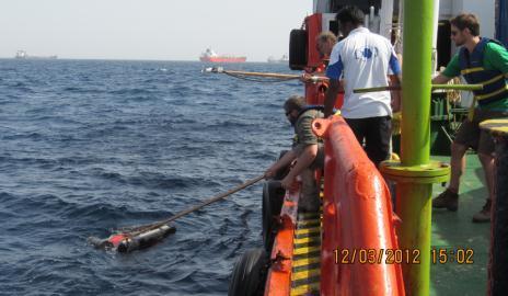
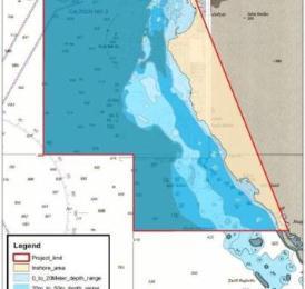
10 Surveying & Mapping Operations Kingdom of Saudi Arabia Hydrographic Survey Operations Airborne Bathy Lidar Multibeam, Sidescan, Sub-bottom Profiling Geodetic & Tidal Control


11 Surveying & Mapping Operations India Coastline Mapping 3 aircraft Photo acquisition 9 cm GSD Post processing of raw image Preliminary aerial triangulation DEM and ortho photo generation


12 Bathymetric Data Processing UKHO Processing dense xyz soundings, producing high resolution contours, contour smoothing, deconfliction and shoal sounding selection. Canadian Hydrographic Service Production of new ENCs from bathy source data Processing of Airborne Bathy Lidar & Multibeam Survey data Saudi Arabia Bathymetric data processing and LiDAR processing
 over 200 ENCs Norwegian Hydrographic Service Australia upgrade 300 ENCs Brazil over 120 ENCs New Zealand 20 ENCs France (SHOM)")
13 ENC Production & Maintenance UK Hydrographic Office - over 2000 ENCs produced NOAA - continual maintenance of 500 ENCs plus production US Army Corps of Engineers - over 7000km of Inland ENCs produced, plus continual maintenance Canadian Hydrographic Service (CHS) over 200 ENCs Norwegian Hydrographic Service Australia upgrade 300 ENCs Brazil over 120 ENCs New Zealand 20 ENCs France (SHOM) Germany (BSH)

14 Paper Chart Compilation US Army Corps of Engineers One of the first paper charts compiled from ENC data Norwegian Hydrographic Service Print-ready paper charts with complex cartography Australia Over 80 paper charts plus Papua New Guinea New Zealand Compiled 20 paper charts
15 Hydrographic Database Systems UK Hydrographic Office Remote production via Citrix of over 200 (of 900) paper chart masters using CARIS HPD Paper Chart Editor (PCE) 10 R&D trials to improve efficiency and capacity Horizontal & vertical deconfliction for complete harmonization Canadian Hydrographic Service Preparing over 100 of charts for HPD loading, including harmonization NOAA Testing ESRI PLTS database systems New Zealand Remote access (via Citrix) to produce100 paper chart masters Delivery of HPD-ready files

16 Training: IIC Academy
 training Oman navy ENC production training Inland Waterways Authority River chart training Indian Hydrographic")
17 Training: IIC Academy IIC Academy is the training division of IIC Technologies Internal and external training: they link and they support Saudi Arabia: IHO S8 Cat B cartographic training Indian Port Authority Multibeam Echo Sounder (MBES) training Oman navy ENC production training Inland Waterways Authority River chart training Indian Hydrographic Office
18 #1 Case Study: Cat B S8 Course

19 #1 Case Study: Cat B S8 Course 15 week course plus 11 weeks of practical work - Flexible delivery

 Remote Sensing for Hydrographers Photogrammetry Image Interpretation for")
20 #1 Case Study: Cat B S8 Course Marine Geospatial Information (rather than Cartography ) Example modules: Marine geology Evaluating bathymetry for charting ENC data creation and editing Emerging standards: S100 Update and maintenance Nautical publications Marine Spatial Data Infrastructure (MSDI) Remote Sensing for Hydrographers Photogrammetry Image Interpretation for Nautical Charting
 Providing trainers, material Assistance to gain their own Cat B Tutors")
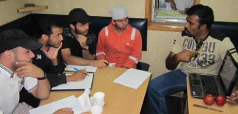
21 #2 Case Study: Saudi Arabia IIC Academy capacity building: Training personnel from the General Commission for Survey Providing course material and mentoring Cartography (S8) Training to Cat B standard Assisted with gaining own Cat B Continuing support in development of processes and procedures Hydrographic Survey (S5) Providing trainers, material Assistance to gain their own Cat B Tutors and mentoring Saudi Arabia is now recognized by IHO/FIG/ICA to provide official S5 and S8 courses


22 #2 Case Study: Saudi Arabia


23 #2 Case Study: Saudi Arabia


24 #2 Case Study: Saudi Arabia

25 #3 Case Study: Oman 6 Month Training on ENC and Paper Chart Production o o o o o Training in Hyderabad, India Classroom followed by Practical work Fully embedded within the IIC Production Environment Exposure to all Production & Process Flows Help in the setup of a ENC/Paper Chart Production Environment
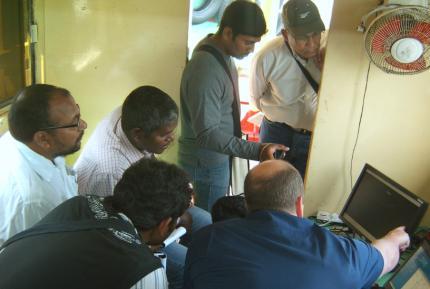
26 #4 Case Study: MBES Course Week-long multibeam echosounder (MBES) course Training in Vizag, India Course offered earlier this year Classroom and shipboard practical work Full setup of hydrographic equipment Actual on-water surveying Processing of survey data at end of week Next course: Jan 28 to Feb 1 (5 days) Completed Course outline available upon request Onsite training at your facility also available

27 #4 Case Study: MBES Course


28 #4 Case Study: MBES Course

29 #4 Case Study: MBES Course
30 Keeping Pace IIC Research & Development Laboratory
31 #5 Case Study: Pending Cat C S8 Four week 22 day Cat C S8 Training in Nautical Cartography Module 1 Source Data analysis, understanding bathymetric surveys and processing them for inclusion within ENCs and Paper Charts Module 2 ENC Production Module 3 Paper Chart Production Module 4 Creation and Issue of Notice to Mariners for Paper Charts and ENC Updates


32 Keeping Pace IIC Research & Development Laboratory

33 Citrix Global Presence Citrix Business Partners Citrix Users 97% of Fortune Global 100 Now Use Citrix Software USA All 20 of the largest U.S. federal agencies All 10 of the top U.S. banks All 10 of the top U.S. automotive manufacturers All 10 of the top U.S. healthcare organizations All 10 of the top U.S. Oil and Gas companies Europe All 10 of the top banks All 10 of the top chemical companies All 10 of the top telecommunications service companies 9 of the top 10 high-tech companies
34 Survey Description Vancouver Survey Site 4000 km Toronto Processing Toronto


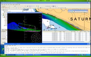
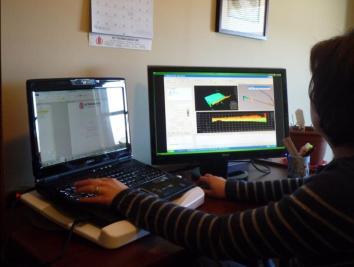
35 Real-time communications. Real-time QA/QC of the data was being performed so the survey could be adapted to correct defects (data gaps, uncertainties outside of specifications, more data needed over certain features to resolve multiple hypotheses, etc.) before the survey crew left the project area Identifying an acquisition data gap I m seeing a gap from yesterday about 14m x 2.3m at N, W problem soundings above a wreck it looks like it got well hit but the on the other hand I m bothered about the small cluster of soundings that got rejected with CUBE> see selected in the subset editor
 Wireless mobile Internet stick:.")
36 Costs. The remote processing side used the existing Internet and existing hardware. No special purpose setup costs were necessary. PC box: ~$1000 Standard IT software:..~ $100 (OS, antivirus, text editor, ftp client site licensing and/or open source) Wireless mobile Internet stick:.~ $150 month to month plan (or free on a 3-year contract); Specialized software: pricing dependent on individual vendor agreements; CARIS HIPS, BASE Editor, Fledermaus, etc. Two to three days if IT support to set it all up and test it. Ongoing costs Citrix GoToMyPC remote access flexible plan... $35/month first 500MB for each additional 500MB. (daily usage is about 100MB/day) $5/month Ongoing IT support and system maintenance
37 Conclusion IIC Technologies has experience in Hydrographic Surveying Data Acquisition Data Cleaning and Processing Workflow ENC & Paper Chart Production Verification & Validation Database Maintenance Workflow IIC Academy provide training & education Onsite and offsite Transferable training skills and courses Assist with IHO/FIG/ICA recognition Provide ongoing mentoring and assistance Provide ongoing course maintenance and upgrades

38 January 29-30, th Workshop on Electronic Charting
Myanmar Naval Hydrographic Centre. National Report for 13 th North Indian Ocean Hydrographic Commission Meeting
 Myanmar Naval Hydrographic Centre National Report for 13 th North Indian Ocean Hydrographic Commission Meeting Yangon, Myanmar 19 th 22 nd February 2013 CONTENT 1. Myanmar Naval Hydrographic Centre 2.
VDatum and SBET to Improve Accuracy of NOAA s High-Resolution Bathymetry
 VDatum and SBET to Improve Accuracy of NOAA s High-Resolution Bathymetry US HYDRO 2007 Extended Abstract Author: Crescent H. Moegling CoAuthor: Steve Brodet Moegling HYDRO 2007 1 Introduction NOAA s Hydrographic
EGYPTIAN HYDROGRAPHIC DEPARTMENT THE EGYPTIAN HYDROGRAPHIC FRAMEWORK
 gvt THE EGYPTIAN HYDROGRAPHIC FRAMEWORK The roles of a national Hydrographic Service can be summarized in collecting georeferenced data through systematic surveys at sea and along the coast related to:
MBSHC (Mediterranean and Black Seas Hydrographic Commission) XVII. conference, Greece Jun. 2011
 XVII. conference, Greece Jun. 2011") MBSHC (Mediterranean and Black Seas Hydrographic Commission) XVII. conference, Greece 01. 03. Jun. 2011 National report of SLOVENIA 01. May 2011 MBSHC report - SLOVENIA 1 0 Index 0 Index... 2 1 Hydrographic
MBSHC (Mediterranean and Black Seas Hydrographic Commission) XVII. conference, Greece 01. 03. Jun. 2011 National report of SLOVENIA 01. May 2011 MBSHC report - SLOVENIA 1 0 Index 0 Index... 2 1 Hydrographic
NOAA s National Ocean Service / Office of Coast Survey
 Coast Survey OCS 1807 2007 Maintains over 1000 nautical charts & 9 Coast Pilots Surveys over 3.4M SNM of oceans and lakes Conducts research and development in hydrography Thomas Jefferson Founder of The
National Report of Finland
 National Report of Finland 1. Finnish Hydrographic Office The Finnish Hydrographic Office is organized under The Finnish Transport Agency. The Finnish Transport Agency is responsible for the Finnish roads,
Use of laser bathymetry at the German Baltic Sea coast. 9 November, 2016
 Use of laser bathymetry at the German Baltic Sea coast 9 November, 2016 Content Initial situation and aim of the project Organization and implementation Conclusions and next steps 16.02.2017 Ellmer: Laserbathymetry
INGESTION OF JALBTCX ALB DATASET INTO NOAA'S CHART PRODUCTION
 INGESTION OF JALBTCX ALB DATASET INTO NOAA'S CHART PRODUCTION Shachak Pe eri (JHC/CCOM) and Gretchen Imahori (NOAA) OCS/MCD (NOAA): John Barber, Anthony Klemm, Julia Powell, Mike Brown and John Nyberg
Department of Marine Science The University of Southern Mississippi and
 Continuing Development of the FIG/ Approved Category A Master of Science Degree in Hydrographic Science Program at The University of Southern Mississippi David Dodd 1, Ken Barbor 2, Stephan Howden 1, Charles
OFFSHORE ANALYSIS & RESEARCH SOLUTIONS HOUSTON PETROLEUM SURVEYORS GROUP PERSONNEL DATA PROCESSING PARTNERSHIPS
 OFFSHORE ANALYSIS & RESEARCH SOLUTIONS HOUSTON PETROLEUM SURVEYORS GROUP KEEPING YOUR PROJECTS IN MOTION OARS-HPSG combines the experience of two highly complementary organizations providing expanded capabilities,
Marine Institute Job Description
 Marine Institute Job Description Position Contract Service Group Location Temporary Scientific & Technical Officer (STO), Hydrographic Data Processor (INFOMAR) Temporary specified purpose contract for
IENC production at the Flemish Hydrography. HYDRO12, 15 th November 2012 Jasmine Dumollin
 IENC production at the Flemish Hydrography HYDRO12, 15 th November 2012 Jasmine Dumollin ENC versus Inland ENC Definition Inland ENC Database, standardized as to content, structure and format, for use
The ship RV Timba repairs are now almost complete and it is expected that come September 2014 the ship will be fully operational.
 Malawi National Report 2014 1 Malawi Hydrographic Office The assembly of the 70 ton ship RV Timba with the assistance of the French government in 1989 ushered in the commencement of modern hydrographic
PAPUA NEW GUINEA HYDROGRAPHIC SERVICE
 PAPUA NEW GUINEA HYDROGRAPHIC SERVICE IHO SOUTH WEST PACIFIC HYDROGRAPHIC COMMISSION (SWPHC) 9 th Meeting Port Moresby, Papua New Guinea, 10-11 March 2007 SWPHC9-01PNG 1. INTRODUCTION 9 th SOUTH WEST PACIFIC
FOREWORD. IHO S-100 Working Group
 IHO International Hydrographic Organization KHOA Korea Hydrographic and Oceanographic Agency MUCH MORE THAN JUST NAUTICAL CHARTS IHO UNIVERSAL HYDROGRAPHIC data MODEL This document was produced with the
PRODUCTS AND SERVICES FOR THE MARITIME COMMUNITY. Ed Martin, Chief Customer Affairs Branch Navigation Services Division Monday, 27 October, 2008
 PRODUCTS AND SERVICES FOR THE MARITIME COMMUNITY Ed Martin, Chief Customer Affairs Branch Navigation Services Division Monday, 27 October, 2008 Coral Reef Conservation International Collaboration Marine
MESOAMERICAN AND CARIBBEAN HYDROGRAPHIC COMMISSION 11 th Meeting, Paramaribo, Suriname, Novembro NATIONAL REPORT BRAZIL
 Page 1 of 5 MESOAMERICAN AND CARIBBEAN HYDROGRAPHIC COMMISSION 11 th Meeting, Paramaribo, Suriname, Novembro 8-12 2010 NATIONAL REPORT BRAZIL 1. Hydrographic Office / Service: Directorate of Hydrography
CAPACITY BUILDING PLAN Programme document for the period
 INTERNATIONAL HYDROGRAPHIC ORGANIZATION MESO AMERICAN & CARIBBEAN SEA HYDROGRAPHIC COMMISSION 1. INTRODUCTION CAPACITY BUILDING PLAN Programme document for the period 2013-2017 1.1. Rationale It is estimated
United States-Canada Hydrographic Commission (USCHC) Meeting
 Meeting") International Hydrographic Organization United States - Canada Hydrographic Commission International Hydrographic Organization (IHO) United States-Canada Hydrographic Commission (USCHC) Meeting 16 May
International Hydrographic Organization United States - Canada Hydrographic Commission International Hydrographic Organization (IHO) United States-Canada Hydrographic Commission (USCHC) Meeting 16 May
A Report On Tide Gauges In Singapore. 1 The Republic of Singapore is an island city-state situated at the southern tip of
 A Report On Tide Gauges In Singapore Introduction 1 The Republic of Singapore is an island city-state situated at the southern tip of Peninsula Malaysia, approximately 1 north of the equator. It consists
United States - Canada Hydrographic Commission Halifax, Canada May 16, 2016
 United States - Canada Hydrographic Commission Halifax, Canada May 16, 2016 USCHC39 INF-E NOAA Pilot Study Applying Satellite-Derived Bathymetry to Longboat Pass, Florida Submitted by: The United States
A guideline for establishing feature and symbol standard management system for national HOs
 A guideline for establishing feature and symbol standard management system for national HOs Joint 26th TSMAD and 5th DIPWG Meeting Silver Spring, Maryland, USA(10-14 June 2013) Republic of Korea (ROK)
Future of ocean mapping, hydrography, policy and public perception
 Future of ocean mapping, hydrography, policy and public perception Mustafa IPTES Director, IHO Busan, 15 November 2017 OUTLINE Current status of Ocean Mapping Ongoing Ocean Mapping Activities New Initiatives
Instruction with Hands-on Practice: Creating a Bathymetric Database & Datum Conversion
 Instruction with Hands-on Practice: Creating a Bathymetric Database & Datum Conversion Tanya Beck Coastal and Hydraulics Laboratory Engineer Research and Development Center May 17, 2010 US Army Corps of
Integration of Multibeam Echo Sounder (MBES) and Airborne LiDAR bathymetry (ALB) and topography data for S57-compliant ENC Charting Surveys
 and Airborne LiDAR bathymetry (ALB) and topography data for S57-compliant ENC Charting Surveys") Integration of Multibeam Echo Sounder (MBES) and Airborne LiDAR bathymetry (ALB) and topography data for S57-compliant ENC Charting Surveys Authors: Don VENTURA (Fugro Pelagos Inc.) United States of America,
Integration of Multibeam Echo Sounder (MBES) and Airborne LiDAR bathymetry (ALB) and topography data for S57-compliant ENC Charting Surveys Authors: Don VENTURA (Fugro Pelagos Inc.) United States of America,
National Report of Finland
 National Report of Finland [31 August 2010] Executive Summary This Report gives an overview of the main activities of the Finnish Hydrographic Office (FHO) since the previous BSHC 14 th Conference. The
High precision hydrography The St. Lawrence River channel HD Bathymetry, Production, Distribution and Updating
 HYDRO12 Conference High precision hydrography The St. Lawrence River channel HD Bathymetry, Production, Distribution and Updating M. Journault, L. Maltais, and R. Sanfaçon Canadian Hydrographic Service
Multibeam Echosounder Metadata and Quality Statistics
 Multibeam Echosounder Metadata and Quality Statistics Dave Mann, Survey Support Manager, Gardline Geosurvey Gardline MBES Systems Sea Explorer EM1002 RV Triton EM1002(S) Ocean Seeker EM1002(S) Ocean Endeavour
Services Overview. Northeast Blueprint
 Services Overview 2D CAD Conversions Paper to CAD 2D CAD Conversions Construction Engineering / CAD Services Construction Markups Consultant Drawings Coordinated Drawings As -Builts Steel Structural Detailing
Progress Towards the Seamless Combination of Bathymetric and Topographic Data in New Zealand
 Progress Towards the Seamless Combination of Bathymetric and Topographic Data in New Zealand Matt Amos Senior Technical Advisor National Geodetic Office Introduction Datasets usually defined in terms of
Seamless Digital Data and Vertical Datums
 Seamless Digital Data and Vertical Datums Ruth ADAMS, United Kingdom Key words: seamless data, vertical datums, Chart Datum, digital data, UKHO. SUMMARY The creation of accurate seamless digital data requires
SECTION III NM 24/15 MARINE INFORMATION
 SECTION III NM 24/15 MARINE INFORMATION NATIONAL GEOSPATIAL-INTELLIGENCE AGENCY'S (NGA) GUIDANCE ON THE PROPER DISPLAY SCALE OF DIGITAL NAUTICAL CHART (DNC) DATA The DNC portfolio was originally created
56 th NHC Meeting May 21-23, 2012 Copenhagen, Denmark. Draft Minutes. [May 23, 2012]
![56 th NHC Meeting May 21-23, 2012 Copenhagen, Denmark. Draft Minutes. [May 23, 2012]](/thumbs/91/107654306.jpg "56 th NHC Meeting May 21-23, 2012 Copenhagen, Denmark. Draft Minutes. [May 23, 2012]") NHC/56 Draft Minutes 56 th NHC Meeting May 21-23, 2012 Copenhagen, Denmark Draft Minutes [May 23, 2012] Venue: Chair: Secretary: Participants: The Danish Royal Academy of Sciences and Letters, Klasseværelset
NHC/56 Draft Minutes 56 th NHC Meeting May 21-23, 2012 Copenhagen, Denmark Draft Minutes [May 23, 2012] Venue: Chair: Secretary: Participants: The Danish Royal Academy of Sciences and Letters, Klasseværelset
KONGSBERG seafloor-mapping echosounders
 KONGSBERG seafloor-mapping echosounders Berit Horvei WORLD CLASS through people, technology and dedication AGENDA Historical overview EM series Multibeam echosounder and Subbottom profiler Topside software.
Overview of Tides and Water Levels
 Overview of Tides and Water Levels www.tidesandcurrents.noaa.gov New Orleans, Baton Rouge, Lafayette, LA March 2009 Gerald Hovis, NOAA - National Ocean Service William Sweet, NOAA - National Ocean Service
There is also need to acquire equipment such as GPS, Echo-Sounder and update data acquisition and processing software among other requirements.
 Malawi National Report 2016 1 Malawi Hydrographic Office The mandate of the Hydrographic office is to carry out surveys of Lake Malawi including the lesser lakes of Malombe, Chilwa and Chiuta as well as
Marine Institute Job Description
 Marine Institute Job Description 02-02-2015 Position Contract Service Group Location Scientific & Technical Officer, Hydrographic Data Processor (INFOMAR) Temporary Specified Purpose, up to end 2018 (INFOMAR
SAUDI ARABIA FUGRO-SUHAIMI LTD. UNDERSTANDING your operational objectives. TACKLING your complex challenges. DELIVERING your global success stories
 SAUDI ARABIA FUGRO-SUHAIMI LTD. UNDERSTANDING your operational objectives TACKLING your complex challenges DELIVERING your global success stories FUGRO-SUHAIMI LTD Fugro-Suhaimi Ltd (FSL) a 50/50 partnership
Kordil Surveying & Engineering Services
 Kordil Surveying & Engineering Services About Kordil Kordil Surveying & Engineering Ltd. Co. in short Kordil is an all in one surveying company providing service from Turkey. Hydrography, Oceanography
GIS Applications in the Saudi Aramco Offshore Hydrographic Surveying Environment
 GIS Applications in the Saudi Aramco Offshore Hydrographic Surveying Environment Fahad Al-Amri & Dr. Kevin Gibson Hydrographic Survey Unit, Saudi Aramco Tel: 038807822 Mobile: 0504617872 fahad.amri@aramco.com
Handling Interferometric Data: Streamlining the Processing Flow
 Handling Interferometric Data: Streamlining the Processing Flow Paper 5 at Hydro8, 4 th November 2008 Tom Hiller, Advanced Products Manager, GeoAcoustics Ltd. WORLD CLASS through people, technology and
Fugro commence new Airborne Lidar Bathymetry trials
 Fugro commence new Airborne Lidar Bathymetry trials Laurent Pronier 20 May 2011 Marrakech, Morocco, 18-22 May 2011 Contents Menu LADS Technology - History LADS Mk I (RAN LADS I) LADS Mk II RAN LADS II
... Salient Ocean Issues that have arisen during 2002
 ... As reported in paragraph 62 of the resolution Oceans and the law of the seas, we are especially pleased with the focus for this meeting, given that protecting vulnerable marine ecosystems and safety
World-Wide Navigational Warning Service Sub-Committee WWNWS-5 Monaco, 1-4 October S-100 Basics Background Brief
 International Hydrographic Organization World-Wide Navigational Warning Service Sub-Committee WWNWS-5 Monaco, 1-4 October 2013 S-100 Basics Background Brief Gilles Bessero 15:29 1 S-100 Basics S-100 -
GLMTF November 18, 2014 Presentation
 GLMTF November 18, 2014 Presentation Michigan Security Network Founded by major corporations, industry leaders and leading universities in 2008 as a non-profit organization (501c6). MiSN mission is to
The Normal Baseline. Dick Gent Law of the Sea Division UK Hydrographic Office
 The Normal Baseline Dick Gent Law of the Sea Division UK Hydrographic Office 2 The normal baseline for measuring the breadth of the territorial sea is the low water line along the coast as marked on large
LT Matthew Forney, NOAA Navigation Manager Alaska Region Bering Strait MaritimeSymposium. Office of Coast Survey
 NOAA LT Matthew Forney, NOAA Navigation Manager Alaska Region Bering Strait MaritimeSymposium Who is Coast Survey? First science agency of the U.S. Formed in 1807 Responsible for surveying 3.4 million
Object Detection for Underwater Port Security
 Object Detection for Underwater Port Security Dr. Lloyd Huff LCHUFF CONSULTANCY,LLC Mr. John Thomas TRITON IMAGING,INC Shallow Survey 2012 February 22, 2012 INTRODUCTION I am glad to be here today to make
Paper for Consideration by S-100WG3. Report on S-100 Sea trial of KHOA
 S-100WG3-8.1 Paper for Consideration by S-100WG3 Report on S-100 Sea trial of KHOA Submitted by: Executive Summary: Related Documents: Related Projects: Republic of Korea (KHOA) This paper reports the
SPAIN NATIONAL REPORT/ ეროვნული ანგარიში.
 SPAIN NATIONAL REPORT/ ეროვნული ანგარიში http://www.armada.mde.es/ihm. 2 Index 1. Hydrographic Offices 2. Surveys 3. Charts and updates 4. Publications and updates 5. MSI 6. C-55 7. Capacity Building 8.
Overview of Recent Tidal Projects in the United States
 1 st Tides and Water Levels Working Group Meeting Overview of Recent Tidal Projects in the United States Stephen Gill National Oceanic and Atmospheric Administration, National Ocean Service Center for
Appendix A Lower Columbia River Chart Datum Modeling
 Appendix A Lower Columbia River Chart Datum Modeling David Evans and Associates, Inc. David Evans and Associates, Inc. 2801 SE Columbia Way, Ste. 130 Vancouver, WA 98661 (360) 314-3200 1.0 Vertical Datum
Old House Channel Bathymetric and Side Scan Survey
 FIELD RESEARCH FACILITY DUCK, NC Old House Channel Bathymetric and Side Scan Survey COASTAL AND HYDRAULICS LABORATORY FIELD DATA COLLECTION AND ANALYSIS BRANCH Michael Forte December 2009 View looking
NAUTICAL CHARTS OF THE BRAZILIAN COAST FOR SMALL CRAFT
 International Hydrographic Review, Monaco, LXIX(2), September 1992 NAUTICAL CHARTS OF THE BRAZILIAN COAST FOR SMALL CRAFT by Eliana Fernandez LIRA 1and Fernando AMADEO 2 Abstract Brazil, a country of continental
Building A New National Hydrographic Service: The Italian-Lebanese Collaboration
 Building A New National Hydrographic Service: The Italian-Lebanese Collaboration Lamberto Orlando LAMBERTI and Nicola Marco PIZZEGHELLO (Italy), Afif GHAITH, Elie el JBEILY and Christian FAHED (Lebanon)
Pipeline Inspection and Environmental Monitoring Using AUVs
 Pipeline Inspection and Environmental Monitoring Using AUVs Bjørn Jalving, Bjørn Gjelstad, Kongsberg Maritime AUV Workshop, IRIS Biomiljø, 7 8 September 2011 WORLD CLASS through people, technology and
POSITION & ORIENTATION SYSTEMS FOR MARINE VESSELS
 POSITION & ORIENTATION SYSTEMS FOR MARINE VESSELS Applanix POS MV is the marine-survey industry s most accurate, robust, and reliable position and orientation solution available today. Representing the
NATIONAL VDATUM -- THE IMPLEMENTATION OF A NATIONAL VERTICAL DATUM TRANSFORMATION DATABASE
 NATIONAL VDATUM -- THE IMPLEMENTATION OF A NATIONAL VERTICAL DATUM TRANSFORMATION DATABASE Bruce Parker, Dennis Milbert, Kurt Hess, and Stephen Gill National Ocean Service, NOAA The National Ocean Service
AIRPORT MAPPING JUNE 2016 EXPLORING UAS EFFECTIVENESS GEOSPATIAL SLAM TECHNOLOGY FEMA S ROMANCE WITH LIDAR VOLUME 6 ISSUE 4
 VOLUME 6 ISSUE 4 JUNE 2016 AIRPORT MAPPING 18 EXPLORING UAS EFFECTIVENESS 29 GEOSPATIAL SLAM TECHNOLOGY 36 FEMA S ROMANCE WITH LIDAR Nearly 2,000 U.S. landfill facilities stand to gain from cost-effective
NAUTICAL CHARTING IN SMALLER COUNTRIES WITH SHORT COASTLINE - TROUBLES AND ADVANTAGES
 NAUTICAL CHARTING IN SMALLER COUNTRIES WITH SHORT COASTLINE - TROUBLES AND ADVANTAGES Igor KARNICNIK, M.Sc. Dalibor RADOVAN (Geodetic Institute of Slovenia, Jamova 2, Ljubljana, Slovenia; igor.karnicnik@geod-is.si)
Hydrographic processing considerations in the Big Data age: An overview of technology trends in ocean and coastal surveys
 IOP Conference Series: Earth and Environmental Science PAPER OPEN ACCESS Hydrographic processing considerations in the Big Data age: An overview of technology trends in ocean and coastal surveys To cite
Lecture 1 Introduction to Remote Sensing
 Lecture 1 Introduction to Remote Sensing Dr Ian Leiper School of Environmental and Life Sciences Bldg Purple 12.2.27 1 2 Lecture Outline Introductions Unit admin Learning outcomes Unit outline Practicals
FRENCH NATIONAL REPORT TO THE 6 TH MEETING OF THE ROPME HYDROGRAPHIC COMMISSION
 Paris, January, 30th 2015 SERVICE HYDROGRAPHIQUE ET OCEANOGRAPHIQUE DE LA MARINE N 003 SHOM/DMI/REX/NP DIRECTION DES MISSIONS INSTITUTIONNELLES ET DES RELATIONS INTERNATIONALES Dossier suivi par IPETA
THE DEVELOPMENT OF CHINESE CHART IN THE 20TH CENTURY AND THE PROSPECTS FOR THE 21ST CENTURY
 THE DEVELOPMENT OF CHINESE CHART IN THE 20TH CENTURY AND THE PROSPECTS FOR THE 21ST CENTURY Li Shujun Hydrography and Mapping Department, Dalian Naval Academy, Dalian, CHINA,116018 E-mail : gh78088@online.
i-tech SERVICES DELIVERING INTEGRATED SERVICES AND PRODUCTS ACROSS THE FIELD LIFE CYCLE
 i-tech SERVICES DELIVERING INTEGRATED SERVICES AND PRODUCTS ACROSS THE FIELD LIFE CYCLE 3 About us 4 What we do 6 Why choose us? 7 Service and product capabilities OUR VALUES Safety Integrity Innovation
Solutions for a blue planet
 Solutions for a blue planet Optimising the businesses of offshore and shallow water professionals with sustainability as our beacon The world is seeing a steady increase in operations at sea in the energy,
APPLICATIONS OF KINEMATIC GPS AT SHOM
 International Hydrographic Review, Monaco, LXXVI(1), March 1999 APPLICATIONS OF KINEMATIC GPS AT SHOM by Michel EVEN 1 Abstract The GPS in kinematic mode has now been in use at SHOM for several years in
INTERNATIONAL OIL AND GAS CONFERENCE IN CHINA OPENING PLENARY SESSION OPPORTUNITIES AND CHALLENGES IN A VOLATILE ENVIRONMENT, BEIJING, JUNE 2010
 Thank you very much for that kind introduction Mr. Chairman it s an honour to be here today at this International Oil & Gas Conference and Exhibition in China. My fellow panel members have described the
Recent Developments in NOAA s Real- Time Coastal Observing Systems for Safe and Efficient Maritime Transportation
 Recent Developments in NOAA s Real- Time Coastal Observing Systems for Safe and Efficient Maritime Transportation Rich Edwing, Director NOAA Center for Operational Oceanographic Products and Services CMTS
REPORT. Technical Visit THE ISLAMIC REPUBLIC OF IRAN February 2007
 REPORT Technical Visit to THE ISLAMIC REPUBLIC OF IRAN 20-22 February 2007 2 Technical Visit to the Islamic Republic of Iran (IHO Work Program 2007, Tasks 2.1.7 and 2.1.10) 20-22 February 2007 I.- General
1 st MEETING OF THE IHO COUNCIL
 C1-3.1 1 st MEETING OF THE IHO COUNCIL Monaco, 17-19 October 2017 REPORT OF THE IHO HYDROGRAPHIC SERVICES AND STANDARDS COMMITTEE C1-3.1 - P a g e 3 REPORT OF THE HYDROGRAPHIC STANDARDS AND SERVICES COMMITTEE
Western Region enavigation Sub- Committee Report
 Western Region enavigation Sub- Committee Report Western Region enavigation meeting - Jan 12 18 BC Ferries BC Coast Pilots BCIT Marine Campus Canadian Coast Guard Canadian Hydrographic Services Canadian
Malawi National Report Malawi Hydrographic Office
 Malawi National Report 2013 1 Malawi Hydrographic Office The Malawi Hydrographic Office was started 30 years after the federal government hydrographic surveys. In the year 1989 the 70-ton ship RV Timba
INTEGRATING BATHYMETRY, TOPOGRAPHY, AND SHORELINE, AND THE IMPORTANCE OF VERTICAL DATUMS
 INTEGRATING BATHYMETRY, TOPOGRAPHY, AND SHORELINE, AND THE IMPORTANCE OF VERTICAL DATUMS Bruce Parker, Dennis Milbert, Kurt Hess, and Stephen Gill National Ocean Service, NOAA 1315 East-West Highway Silver
About us. Our Purpose
 About us The Hydrographic Society UK is an independent, non-profit making, non-governmental, learned professional society. We provide a forum for all those involved in activities related to hydrography
Technology Accreditation Canada (TAC) SURVEY/GEOMATICS TECHNOLOGY TECHNOLOGIST Canadian Technology Accreditation Criteria (CTAC)
 SURVEY/GEOMATICS TECHNOLOGY TECHNOLOGIST Canadian Technology Accreditation Criteria (CTAC)") Technology Accreditation Canada (TAC) SURVEY/GEOMATICS TECHNOLOGY TECHNOLOGIST Canadian Technology Accreditation Criteria (CTAC) Preamble These CTAC are applicable to programs having titles involving Survey/Geomatics
Technology Accreditation Canada (TAC) SURVEY/GEOMATICS TECHNOLOGY TECHNOLOGIST Canadian Technology Accreditation Criteria (CTAC) Preamble These CTAC are applicable to programs having titles involving Survey/Geomatics
11 th CHRIS MEETING IHB, Monaco, November Draft - - -
 CHRIS/11/16A 11 th CHRIS MEETING IHB, Monaco, 16-18 November 1999 - - - Draft - - - Workshop on Development of Marine Information Objects (MIO) for ECDIS Burlington, Ontario, Canada 8-9 November 1999 Record
Joining New Zealand Land and Sea Vertical Datums (JLAS) Graeme Blick Group Manager Positioning and Resilience
 Graeme Blick Group Manager Positioning and Resilience") Presented at the FIG Congress 2018, May 6-11, 2018 in Istanbul, Turkey Joining New Zealand Land and Sea Vertical Datums (JLAS) Graeme Blick Group Manager Positioning and Resilience Mapping NZ 2025 What
Presented at the FIG Congress 2018, May 6-11, 2018 in Istanbul, Turkey Joining New Zealand Land and Sea Vertical Datums (JLAS) Graeme Blick Group Manager Positioning and Resilience Mapping NZ 2025 What
Experienced project management Total flexibility of the workforce Modern drydocking facilities
 Engineering Excellence for the Global Shipping, Marine, Defence and Oil & Gas industries from three Strategic locations across the UK NORTH EAST tyne tees Our two North East England facilities provide
Object Detection with Phase-Measuring Bathymetric Sidescan Sonar Depth Data
 Object Detection with Phase-Measuring Bathymetric Sidescan Sonar Depth Data Kevin Jerram and Val Schmidt Center for Coastal and Ocean Mapping Durham, New Hampshire A shipwreck and bedforms are visible
Questionnaire about the Depiction of the Quality of the Data in Nautical Charts
 Questionnaire about the Depiction of the Quality of the Data in Nautical Charts Your answers to this questionnaire, to be returned to the UKHO (see details on last page), will remain anonymous unless you
Option 1. Design Options are diverse e.g. new route alignments covering a wide area. Option 2. Design Options are restricted
 MINIMUM STANDARD Z/16 SURVEY SPECIFICATIONS 1. GENERAL This specification sets out the Consultant s requirements for topographical survey (ground and aerial) for the Detailed Business Case (DBC) and Pre-Implementation
Seafloor Mapping Using Interferometric Sonars: Advances in Technology and Techniques
 Seafloor Mapping Using Interferometric Sonars: Advances in Technology and Techniques Tom Hiller, Advanced Products Manager, GeoAcoustics Ltd. WORLD CLASS through people, technology and dedication Brest,
GEO-MARINE TECHNOLOGY, INC. A Geological, Geophysical, and Hydrographic Survey Consultancy
 COMPANY PROFILE OUR MISSION AND TRADE OUR MISSION: OUR TRADE: We few, professional scientists strive to support the objectives of our marine energy and telecommunications clients with cooperation, innovation
Production of Electronic Chart using updated survey data for EL-Arish harbor
 ARAB ACADEMY FOR SCIENCE AND TECHNOLOGY AND MARITIME TRANSPORT Alexandria, Egypt Production of Electronic Chart using updated survey data for EL-Arish harbor Submitted By ASHRAF NABIL HASSAN EL-ASSAL B.SC.
Maritime Administration of Latvia (MAL) Hydrographic Service National Report to Baltic Sea Hydrographic Commission
 Hydrographic Service National Report to Baltic Sea Hydrographic Commission") Maritime Administration of Latvia (MAL) Hydrographic Service National Report to Baltic Sea Hydrographic Commission Executive summary 2016 The Report gives an overview of the main activities of Hydrographic
Maritime Administration of Latvia (MAL) Hydrographic Service National Report to Baltic Sea Hydrographic Commission Executive summary 2016 The Report gives an overview of the main activities of Hydrographic
SOME ASPECT AND PERSPECTIVES OF IMPLEMENTATION OF THE NATIONAL POLICY IN THE FIELD OF EXPLORATION AND PEACEFUL USES OF OUTER SPACE
 SOME ASPECT AND PERSPECTIVES OF IMPLEMENTATION OF THE NATIONAL POLICY IN THE FIELD OF EXPLORATION AND PEACEFUL USES OF OUTER SPACE 1 Folie 1 NKS Raumfahrt, Dr. Adrian klein Background National Academy
Teledyne Marine Acoustic Imagining
 RESON SeaBat high performance sonars for long range object detection and MCM applications Navigation, object avoidance & up close inspection with BlueView Greg Probst Sales Manager, Defense Teledyne Marine
SECTION III NM 39/13 MARINE INFORMATION NGA CHART NEW EDITIONS AND THEIR AVAILABILITY
 SECTION III NM 39/13 MARINE INFORMATION NGA CHART NEW EDITIONS AND THEIR AVAILABILITY NGA standard nautical hardcopy chart products are made available and distributed by three different authorized methods:
Figure 1. Overview of Critical and Emerging Critical Areas along Columbia River
 GPS Derived Water Levels for Large Scale Hydrographic Surveys: Implementation of a Separation Model of the Columbia River Datum, A Case Study Crescent H. Moegling 1, Jon L. Dasler 2, Jason C. Creech 3,
PSAS. Welcome!! And thanks to our sponsors: Akamai Technologies Liberty Mutual Insurance General Motors Corp.
 Welcome!! And thanks to our sponsors: Akamai Technologies Liberty Mutual Insurance General Motors Corp. Statistics 264 registered from 13 countries and 5 continents USA Brazil Japan China Netherlands Germany
WHAT DOES FIG SURVEYORS EXPECT IN COLLABORATIVE PARTNERSHIP WITH IGS
 WHAT DOES FIG SURVEYORS EXPECT IN COLLABORATIVE PARTNERSHIP WITH IGS Larry D. Hothem, Past Chair, FIG Commission 5, Positioning and Measurement U.S. Geological Survey, Reston, Virginia, USA (Lhothem@usgs.gov)
17 th BSHC Conference National Report of Germany
 17 th BSHC Conference National Report of Germany FINAL VERSION August 2012 Executive Summary The present report outlines and summarizes the activities carried out since the 16th BSHC Conference by the
De-recruitments In 2012
 VOS / p. 1 VOS Report for 2012 (Canada) a. Programme description: Category No. of ships at 31 Dec 2012 Recruitments in 2012 De-recruitments In 2012 Comments Selected Selected AWS VOSClim VOSClim AWS 51
HYDROGRAPHIC SURVEY STANDARDS AND DELIVERABLES
 TABLE OF CONTENTS 1. HYDROGRAPHIC SURVEY METHODOLOGY... 3 2. HYDROGRAPHIC SURVEY REFERENCE STANDARDS... 3 3. HYDROGRAPHIC SURVEY CRITERIA... 3 3.1 HYDROGRAPHIC SURVEYS OVER NON GAZETTED NAVIGABLE WATERS*:...
IHO S-100 FRAMEWORK - BASELINE STANDARD FOR E- NAVIGATION MARITIME SERVICES
 UNDERWAY (24 26 January 2018) IHO S-100 FRAMEWORK - BASELINE STANDARD FOR E- NAVIGATION MARITIME SERVICES Abri Kampfer Director, IHO Copenhagen, Denmark (24 26 January 2018) What is the?. intergovernmental
Nordic Hydrographic Commission 60th Conference - Stavanger - Norway April New national ENC service for leisure craft users
 Nordic Hydrographic Commission 60th Conference - Stavanger - Norway 11-13 April 2016 New national ENC service for leisure craft users New national ENC service for leisure craft users The aim of the new
IHO Presentation Offshore Renewables
 IHO Presentation Offshore Renewables Don Ventura 22nd November 2012 Fugro s Resources in Renewables Fugro: Consults Geophysical Data Measures Samples Interprets Integrates Geotechnical Data Environmental
21st International Conference of The Coastal Society
 21st International Conference of The Coastal Society DEVELOPMENT OF A VERTICAL DATUM TRANSFORMATION TOOL AND A BATHYMETRIC/TOPOGRAPHIC DIGITAL ELEVATION MODEL FOR SOUTHERN CALIFORNIA Edward P. Myers, NOAA/NOS
Responsive AUV Localization and Mapping Project. Ron Lewis, Project Manager June 14 th, 2012
 Responsive AUV Localization and Mapping Project Ron Lewis, Project Manager June 14 th, 2012 Project Overview Project duration: Approximately 5 Years June 1, 2010 to March 31, 2015 Primary objectives: Develop