There is also need to acquire equipment such as GPS, Echo-Sounder and update data acquisition and processing software among other requirements.
|
|
|
- Thomas Jefferson
- 5 years ago
- Views:
Transcription
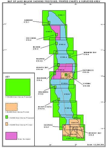
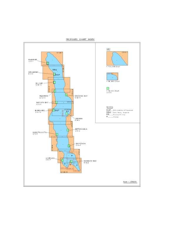
1 Malawi National Report Malawi Hydrographic Office The mandate of the Hydrographic office is to carry out surveys of Lake Malawi including the lesser lakes of Malombe, Chilwa and Chiuta as well as the Shire River. Earnest surveys of Lake Malawi were started in the 1950s by the British Admiralty. After a lapse of about 30 years surveys were resuscitated beginning with the French cooperation in 1989, which was very instrumental in establishing the current Hydrographic office, and then in 1999 the cooperation with Iceland went on up to By this time the Malawi Hydrographic office became well established with an ability to carry out surveys throughout Malawi and wherever there was a requirement to carry out surveys be it in dams, rivers or smaller lakes and on ports of call on the coasts of Lake Malawi. 2 Hydrographic Surveys 40% of the total area of 24000km 2 of Lake Malawi has been surveyed. As of now there still remains a substantial amount of work to be done when the River Shire and the smaller lakes are put in consideration. Problems The ship RV Timba repairs are now complete and as of now the ship engines were tested and sailed a distance of about 30 nautical miles to the port of Chipoka. What remains is for the ship to go through a seaworthiness inspection in order to acquire a certificate of seaworthiness from the Marine Department. Due to the long length of idleness some accessories in the gallery and the crew cabins need replacement. There is also need to acquire equipment such as GPS, Echo-Sounder and update data acquisition and processing software among other requirements. The small launch the RV Timba II which is very useful for coastal and river surveys requires a dedicated positioning and data acquisition equipment to function independently. This launch services surveys in mostly coastal and shoal areas. The purchase of a side scan sonar would assist in achieving 100% bottom coverage to complement the traditional single beam echosounder especially in harbor and critical areas of concern. 3 New Charts & Updates To date the following charts have been produced: Chart No. Series Status C10-8 1:10,000 Printed
2 C10-7 1:10,000 Printed C : 50,000 Printed C : 50,000 Printed C : 50,000 Printed C : 50,000 Printed C10-6B 1:10,000 Ready, Printed on demand using CARIS Software C50-1B 1: 50,000 Ready, Printed on demand using CARIS Software C10-4A 1:10,000 Data acquired & validated C10-2 1:10,000 Data acquired & validated C :100,000 Few profiles to be redone in the field C :100,000 50% of data acquired Chart Index is attached as Annex I Annex II takes into account new developments. This takes care of large scale charts required in areas of significant fishing concerns and the sugar factories in Nkhotakota, Salima and Chikwawa districts in the lakeshore and river Shire areas. ENCs and RNCs are not in production. In addition INT and pleasure Craft charts have not been produced as yet and it is hoped that once the project with Norway materializes will take care of some of these matters. Problems Encountered As far as chart printing is concerned the Departmental printing press has not been functional for some time now. We are currently relying on HP plotters but these have also developed faults which require looking into. There is a general trend that the plotters acquired in these years have not worked according to set out guarantee promised by the manufacturers and even the after service has not been there. We would want to learn from the hydrographic fraternity how they take care of chart production and printing matters.
3 4. New Publications & Updates Surveys for the Nsanje port have been carried out by those involved in the Shire/Zambezi waterway project as part of the whole project hydrographic survey. It is planned the revision of the Lake Malawi Sailing Directions will be carried out later on this year concomitant with surveys for large scale surveys. The Hydrographic office works in close cooperation with the Marine Department in order to adequately chart the priority areas. Problems encountered With the RV Timba about to start survey operations this year it is hoped that preparation of the sailing pilot will resume and that the personnel will gain from the exposure that the training and experience will bring from this Project. Currently this activity has been on the shelf for a long time. 5. Maritime Safety Information (MSI) Nation/Area INT Region Local Warning Malawi H Partial Lake Malawi pilot update Coast Warning Navarea Warning Port Info Master Plan No No Marine Transport Sector The transmission of safety information to Mariners is the responsibility of Marine Services Department. To this effect the Marine Services department is working on a Master Plan for the Marine Transport Sector. Currently there has been no update as concerns further achievements in the matter of the Master Plan. IMO is supposed to carry out an audit scheme which includes safety of navigation and importance of charts. Currently, however the main items for communication are still VHF radios which have indeed compromised safety at critical times when ships need urgent rescue. Problems Encountered The Hydrographic Survey office still intends to work in close cooperation with Marine Department in order to develop reliable Maritime Safety Information. 6. C-55 As has been the case, charts are at scales 1:10000, 1:50000 and 1: With the resources at hand the status of hydrography and nautical cartography may be ranked as fairly good. However with the
4 lapse of time and the inactivity brought about when the survey vessel Timba was idle we have somewhat lagged behind. Still the revival of operations will enable resumption of production of charts and we look forward to this. The C55 status therefore remains the same as during the IHOCBC Malawi Visit Report of Capacity Building It is obvious that personnel have been the major input into the achievements made to date and in order to avoid gaps capacity building needs to be a continuous exercise. Training is thus required in hydrography and nautical cartography. The Government of Malawi has done its part in fulfilling its training obligations by training members at local Universities and occasionally at international training institutions such as the STC in Netherlands. In addition training has been funded by the IHOCBC mainly in South Africa. At an earlier stage training was also provided by France at EPSHOM. In addition training was also provided by the IHO at Trieste in Italy. Currently comprehensive training is sought both at CAT A and B training in Hydrography. Malawi and Mozambique have had multilateral agreements involving hydrographic surveys on Lake Malawi (Niassa) which also involved Iceland. The joint project of the lake boundary between Malawi and Mozambique using CARIS Lots software is now planned to commence from October 2016 after some delays brought about by some unforeseen circumstances. To this aim a bilateral meeting has already taken place in Malawi on the lake boundary work. The Malawi Hydrographic office and Norwegian Hydrographic Service are engaged in a project proposal document to guide them in a possible hydrographic project which it is hoped can now be started considering that the RV Timba is back on sail. From the cooperation it is hoped that we can acquire items such as positioning equipment, sounding equipment, data logging instruments and accompanying softwares which require updating. The Shire-Zambezi waterway project is a regional project facilitated by SADC for integrated transport system within the region. The cooperating partners Zambia, Mozambique and Malawi are committed to bringing the project to fruition in the spirit of integration and transport infrastructure development which has hitherto been done in isolated attempts. Malawi relies greatly on road transport which has made its transport costs to be some of the highest in the world and the coming in of such a project would bring benefits to Malawi and the neighbouring countries in the region. 8. Oceanographic Activities The department of Water resources maintains a network of tide gauges throughout the western part of the including gauges on Lake Malombe and the Shire River.
5 The hydrographic office also maintains one automated pressure tide gauge at Monkey Bay, but additional automatic pressure tide gauges will need to be installed at Nkhota Kota, Nkhata Bay and Chilumba ports in order to complement and check the Water Resources department data. The commencement of operations should revive most of the planned installations. Other oceanographic equipment used by the hydrographic office includes a sound velocity profiler and a Grab corer. GIZ Germany cooperation has delivered to the hydrographic office a winch and motor, a rubber dinghy, a hydrophore water pump, outboard engine and life rafts for the Timba which has been very helpful to the cash strapped economy. Problems encountered The automatic tide gauge and the sound velocity profiler have worked well in the past years but some updating may still be required including the apparently simple task of battery replacement which in view of the time period it may not be certain whether the Suppliers of this item will be readily available or not. 10. Concluding Remarks The Engineering and Deck crew have shown immense capabilities and a milestone has been achieved which was in some circumstances not certain would be achieved considering the length of time that it has taken. We are almost certain that with the right cooperating partner such as Norway we can bring back the successes in the production of modern navigation charts, revision of the Lake pilot and monitoring the lake and river environment. We have also trust in our erstwhile development partners who have shown a willingness to assist us even in the face of adversary. We appreciate the support both past and present from France, Iceland, Germany GIZ and Norway who have pledged to support Malawi including the mother body, the IHO, who have provided short training courses to our staff tirelessly every year and with such support we would like to assure our partners that the noble cause shown will not be in vain. As a country we realize the vital role played by the water infrastructure and the requirement to develop it and not take it for granted. We are therefore happy to be here at the conference and meet again in amicable but serious discussions despite problems of finances that are always glaring their uncanny faces to stop us from sharing with the SAIHC community our zealous and worthy efforts at sustained establishment of a hydrographic concern.
6 Annex 1
7 ANNEX II
The ship RV Timba repairs are now almost complete and it is expected that come September 2014 the ship will be fully operational.
 Malawi National Report 2014 1 Malawi Hydrographic Office The assembly of the 70 ton ship RV Timba with the assistance of the French government in 1989 ushered in the commencement of modern hydrographic
Malawi National Report Malawi Hydrographic Office
 Malawi National Report 2013 1 Malawi Hydrographic Office The Malawi Hydrographic Office was started 30 years after the federal government hydrographic surveys. In the year 1989 the 70-ton ship RV Timba
Myanmar Naval Hydrographic Centre. National Report for 13 th North Indian Ocean Hydrographic Commission Meeting
 Myanmar Naval Hydrographic Centre National Report for 13 th North Indian Ocean Hydrographic Commission Meeting Yangon, Myanmar 19 th 22 nd February 2013 CONTENT 1. Myanmar Naval Hydrographic Centre 2.
LT Matthew Forney, NOAA Navigation Manager Alaska Region Bering Strait MaritimeSymposium. Office of Coast Survey
 NOAA LT Matthew Forney, NOAA Navigation Manager Alaska Region Bering Strait MaritimeSymposium Who is Coast Survey? First science agency of the U.S. Formed in 1807 Responsible for surveying 3.4 million
EGYPTIAN HYDROGRAPHIC DEPARTMENT THE EGYPTIAN HYDROGRAPHIC FRAMEWORK
 gvt THE EGYPTIAN HYDROGRAPHIC FRAMEWORK The roles of a national Hydrographic Service can be summarized in collecting georeferenced data through systematic surveys at sea and along the coast related to:
National Report of Finland
 National Report of Finland [31 August 2010] Executive Summary This Report gives an overview of the main activities of the Finnish Hydrographic Office (FHO) since the previous BSHC 14 th Conference. The
PAPUA NEW GUINEA HYDROGRAPHIC SERVICE
 PAPUA NEW GUINEA HYDROGRAPHIC SERVICE IHO SOUTH WEST PACIFIC HYDROGRAPHIC COMMISSION (SWPHC) 9 th Meeting Port Moresby, Papua New Guinea, 10-11 March 2007 SWPHC9-01PNG 1. INTRODUCTION 9 th SOUTH WEST PACIFIC
MESOAMERICAN AND CARIBBEAN HYDROGRAPHIC COMMISSION 11 th Meeting, Paramaribo, Suriname, Novembro NATIONAL REPORT BRAZIL
 Page 1 of 5 MESOAMERICAN AND CARIBBEAN HYDROGRAPHIC COMMISSION 11 th Meeting, Paramaribo, Suriname, Novembro 8-12 2010 NATIONAL REPORT BRAZIL 1. Hydrographic Office / Service: Directorate of Hydrography
Maritime Administration of Latvia Hydrographic Service National Report to Baltic Sea Hydrographic Commission
 Maritime Administration of Latvia Hydrographic Service National Report to Baltic Sea Hydrographic Commission Executive summary 2017 The Report gives an overview of the main activities of Hydrographic Service
NOAA s National Ocean Service / Office of Coast Survey
 Coast Survey OCS 1807 2007 Maintains over 1000 nautical charts & 9 Coast Pilots Surveys over 3.4M SNM of oceans and lakes Conducts research and development in hydrography Thomas Jefferson Founder of The
Maritime Administration of Latvia (MAL) Hydrographic Service National Report to Baltic Sea Hydrographic Commission
 Hydrographic Service National Report to Baltic Sea Hydrographic Commission") Maritime Administration of Latvia (MAL) Hydrographic Service National Report to Baltic Sea Hydrographic Commission Executive summary 2016 The Report gives an overview of the main activities of Hydrographic
Maritime Administration of Latvia (MAL) Hydrographic Service National Report to Baltic Sea Hydrographic Commission Executive summary 2016 The Report gives an overview of the main activities of Hydrographic
MEDITERRANEAN AND BLACK SEAS HYDROGRAPHIC COMMISSION
 MEDITERRANEAN AND BLACK SEAS HYDROGRAPHIC COMMISSION XVIII CONFERENCE CONTRIBITION BY MALTA Istanbul, Turkey 25-27 September 2013 1 Item 1 Hydrographic Office Transport Malta is responsible for all transport
GLMTF November 18, 2014 Presentation
 GLMTF November 18, 2014 Presentation Michigan Security Network Founded by major corporations, industry leaders and leading universities in 2008 as a non-profit organization (501c6). MiSN mission is to
UNITED KINGDOM NATIONAL REPORT
 SAIHC12-5.3K UNITED KINGDOM NATIONAL REPORT 12 TH SOUTHERN AFRICA AND ISLANDS HYDROGRAPHIC COMMISSION (SAIHC) MEETING Dar es Salaam, Tanzania 22 nd 23 rd September 2015 This report supplements the UK Generic
e-navigation Progress and trends: the IHO perspective
 International Hydrographic Organization e-navigation Progress and trends: the IHO perspective Gilles Bessero Director, IHO International Hydrographic Organization Intergovernmental consultative and technical
Nordic Hydrographic Commission 60th Conference - Stavanger - Norway April New national ENC service for leisure craft users
 Nordic Hydrographic Commission 60th Conference - Stavanger - Norway 11-13 April 2016 New national ENC service for leisure craft users New national ENC service for leisure craft users The aim of the new
REPORT. Technical Visit THE ISLAMIC REPUBLIC OF IRAN February 2007
 REPORT Technical Visit to THE ISLAMIC REPUBLIC OF IRAN 20-22 February 2007 2 Technical Visit to the Islamic Republic of Iran (IHO Work Program 2007, Tasks 2.1.7 and 2.1.10) 20-22 February 2007 I.- General
NAUTICAL CHARTS OF THE BRAZILIAN COAST FOR SMALL CRAFT
 International Hydrographic Review, Monaco, LXIX(2), September 1992 NAUTICAL CHARTS OF THE BRAZILIAN COAST FOR SMALL CRAFT by Eliana Fernandez LIRA 1and Fernando AMADEO 2 Abstract Brazil, a country of continental
There has been some success
 Surveying Hydrography in Africa by Captain Abri Kampfer, Hydrographer SA Navy The International Hydrographic Bureau (IHB) and many member states of the International Hydrographic Organisation (IHO) have
NAUTICAL CHARTING IN SMALLER COUNTRIES WITH SHORT COASTLINE - TROUBLES AND ADVANTAGES
 NAUTICAL CHARTING IN SMALLER COUNTRIES WITH SHORT COASTLINE - TROUBLES AND ADVANTAGES Igor KARNICNIK, M.Sc. Dalibor RADOVAN (Geodetic Institute of Slovenia, Jamova 2, Ljubljana, Slovenia; igor.karnicnik@geod-is.si)
DRAFT ASSEMBLY RESOLUTION A. (26)
") DRAFT ASSEMBLY RESOLUTION A. (26) PROMULGATION OF MARITIME SAFETY INFORMATION The ASSEMBLY, RECALLING Article 15(j) of the Convention on the International Maritime Organization concerning the functions
DRAFT ASSEMBLY RESOLUTION A. (26) PROMULGATION OF MARITIME SAFETY INFORMATION The ASSEMBLY, RECALLING Article 15(j) of the Convention on the International Maritime Organization concerning the functions
Draft submission paper: Hydrographic Offices way on EMODnet. Subject : Hydrographic Offices way on EMODnet. Foreword :
 Subject : Hydrographic Offices way on EMODnet Foreword : This paper is aimed to present the state of the EMODnet project, the European Commission s policy for this project, the principles of the Hydrographic
AMENDMENTS TO RESOLUTION A.705(17) PROMULGATION OF MARITIME SAFETY INFORMATION
 PROMULGATION OF MARITIME SAFETY INFORMATION") E 4 ALBERT EMBANKMENT LONDON SE1 7SR Telephone: +44 (0)20 7735 7611 Fax: +44 (0)20 7587 3210 AMENDMENTS TO RESOLUTION A.705(17) PROMULGATION OF MARITIME SAFETY INFORMATION MSC.1/Circ.1287/Rev.1 24 June
E 4 ALBERT EMBANKMENT LONDON SE1 7SR Telephone: +44 (0)20 7735 7611 Fax: +44 (0)20 7587 3210 AMENDMENTS TO RESOLUTION A.705(17) PROMULGATION OF MARITIME SAFETY INFORMATION MSC.1/Circ.1287/Rev.1 24 June
A guideline for establishing feature and symbol standard management system for national HOs
 A guideline for establishing feature and symbol standard management system for national HOs Joint 26th TSMAD and 5th DIPWG Meeting Silver Spring, Maryland, USA(10-14 June 2013) Republic of Korea (ROK)
Helping Build Your Capacity in Nautical Charting & Hydrography
 Helping Build Your Capacity in Nautical Charting & Hydrography Helping Chart your World Rajesh Alla Riyadh, Kingdom of Saudi Arabia 04-06 March 2013 Company Background Marine Services Capacity Building
UNITED KINGDOM NATIONAL REPORT
 UNITED KINGDOM NATIONAL REPORT TO THE 10 TH MACHC HYDROGRAPHIC COMMISSION MEETING Barbados 4 5 th November 2009 This report supplements the UK Generic National Report 2009, posted on the UKHO website (www.ukho.gov.uk),
MBSHC (Mediterranean and Black Seas Hydrographic Commission) XVII. conference, Greece Jun. 2011
 XVII. conference, Greece Jun. 2011") MBSHC (Mediterranean and Black Seas Hydrographic Commission) XVII. conference, Greece 01. 03. Jun. 2011 National report of SLOVENIA 01. May 2011 MBSHC report - SLOVENIA 1 0 Index 0 Index... 2 1 Hydrographic
MBSHC (Mediterranean and Black Seas Hydrographic Commission) XVII. conference, Greece 01. 03. Jun. 2011 National report of SLOVENIA 01. May 2011 MBSHC report - SLOVENIA 1 0 Index 0 Index... 2 1 Hydrographic
Emerging Subsea Networks
 FIBRE-TO-PLATFORM CONNECTIVITY, WORKING IN THE 500m ZONE Andrew Lloyd (Global Marine Systems Limited) Email: andrew.lloyd@globalmarinesystems.com Global Marine Systems Ltd, New Saxon House, 1 Winsford
National Report of Finland
 National Report of Finland 1. Finnish Hydrographic Office The Finnish Hydrographic Office is organized under The Finnish Transport Agency. The Finnish Transport Agency is responsible for the Finnish roads,
CAPACITY BUILDING PLAN Programme document for the period
 INTERNATIONAL HYDROGRAPHIC ORGANIZATION MESO AMERICAN & CARIBBEAN SEA HYDROGRAPHIC COMMISSION 1. INTRODUCTION CAPACITY BUILDING PLAN Programme document for the period 2013-2017 1.1. Rationale It is estimated
NHC 59th meeting Agenda item NHC59-9A April 14-15, 2015 Reykjavik - Iceland. New national ENC service for leisure craft users
 NHC 59th meeting Agenda item NHC59-9A April 14-15, 2015 Reykjavik - Iceland New national ENC service for leisure craft users The aim of the new ENC service The aim of the new ENC service is to enhance
MARITIME SAFETY INFORMATION
 Introduction 1. Maritime Safety Information (MSI) is defined as navigational and meteorological warnings, meteorological forecasts, and other urgent safety-related messages. This information is of vital
... Salient Ocean Issues that have arisen during 2002
 ... As reported in paragraph 62 of the resolution Oceans and the law of the seas, we are especially pleased with the focus for this meeting, given that protecting vulnerable marine ecosystems and safety
SPAIN NATIONAL REPORT/ ეროვნული ანგარიში.
 SPAIN NATIONAL REPORT/ ეროვნული ანგარიში http://www.armada.mde.es/ihm. 2 Index 1. Hydrographic Offices 2. Surveys 3. Charts and updates 4. Publications and updates 5. MSI 6. C-55 7. Capacity Building 8.
WWNWS9/3/2/XVII_XVIII Meeting 9 21 July 2017 Agenda Item 3.2. MSI Self Assessment NAVAREA XVII_XVIII. Submitted by Canada (Canadian Coast Guard)
") WWNWS WWNWS9/3/2/XVII_XVIII Meeting 9 21 July 2017 Agenda Item 3.2 MSI Self Assessment NAVAREA XVII_XVIII Submitted by Canada (Canadian Coast Guard) SUMMARY Executive Summary: Summary of activities within
WWNWS WWNWS9/3/2/XVII_XVIII Meeting 9 21 July 2017 Agenda Item 3.2 MSI Self Assessment NAVAREA XVII_XVIII Submitted by Canada (Canadian Coast Guard) SUMMARY Executive Summary: Summary of activities within
ECDIS ENC Accuracy. Contents. Introduction LOSS PREVENTION BRIEFING FOR NORTH MEMBER SHIPS / MAY Introduction... 1
 LOSS PREVENTION BRIEFING FOR NORTH MEMBER SHIPS / MAY 2017 ECDIS ENC Accuracy Contents Introduction... 1 ECDIS Specific Familiarisation... 2 IHO S-57... 2 ENC Data Source... 2 CATZOC and M_QUAL... 2 CATZOC
RECOMMENDATIONS LDAC CONFERENCE ON EXTERNAL DIMENSION OF THE CFP LAS PALMAS DE GRAN CANARIA, September 2015
 RECOMMENDATIONS LDAC CONFERENCE ON EXTERNAL DIMENSION OF THE CFP LAS PALMAS DE GRAN CANARIA, 16-17 September 2015 GENERAL STATEMENTS 1. We recognise the progress made with the latest reforms to the exterior
Related documents: None
 WWNWS WWNWS4/3/2/VII Meeting 4 23 August 2012 Agenda Item 3.2.VII 1 MSI Self Assessment NAVAREA VII Submitted by: South Africa SUMMARY Executive Summary: This document provides MSI information related
High performance Marine Products Automatic Identification System
 www.em-trak.com High performance Marine Products Automatic Identification System High performance marine products PRODUCTS APPLICATIONS ABOUT em-trak products are engineered to provide the best performance
DEVELOPMENT OF A DEFINITION FOR MSPS AND CONSIDERATION FOR THE HARMONIZATION OF THE FORMAT AND STRUCTURE OF MSPS
 INTERNATIONAL HYDROGRAPHIC ORGANIZATION E IMO/IHO HARMONIZATION GROUP ON DATA MODELLING Agenda item 5 15 September 2017 ENGLISH ONLY DEVELOPMENT OF A DEFINITION FOR MSPS AND CONSIDERATION FOR THE HARMONIZATION
GMDSS communication systems
 GMDSS Basic Concepts A System Overview Functional requirements The GMDSS (Global Maritime Distress and Safety System) is specifically designed to automate a ship's radio distress alerting function, and,
Joint - Jobs, Enterprise and Innovation. Opening Statement. Brian Hogan Marine Survey Office. Date: 21 September 2017
 Joint - Jobs, Enterprise and Innovation Opening Statement Brian Hogan Marine Survey Office Date: 21 September 2017 I thank the Chairman and Committee Members for inviting me here today. The issues which
Kordil Surveying & Engineering Services
 Kordil Surveying & Engineering Services About Kordil Kordil Surveying & Engineering Ltd. Co. in short Kordil is an all in one surveying company providing service from Turkey. Hydrography, Oceanography
NEW AND AMENDED TRAFFIC SEPARATION SCHEMES
 E 4 ALBERT EMBANKMENT LONDON SE1 7SR Telephone: +44 (0)20 7735 7611 Fax: +44 (0)20 7587 3210 NEW AND AMENDED TRAFFIC SEPARATION SCHEMES COLREG.2/Circ.67 20 May 2016 1 The Maritime Safety Committee, at
USE OF THE RCDS MODE OF ECDIS (Submissions by Australia and Norway to IMO MSC/78)
") IHB File No. S3/8152 CIRCULAR LETTER 21/2004 22 March 2004 USE OF THE RCDS MODE OF ECDIS (Submissions by Australia and Norway to IMO MSC/78) Ref: 1. WEND Letter 1/2004, dated 1 st February 2004 2. IMO
IHB File No. S3/8152 CIRCULAR LETTER 21/2004 22 March 2004 USE OF THE RCDS MODE OF ECDIS (Submissions by Australia and Norway to IMO MSC/78) Ref: 1. WEND Letter 1/2004, dated 1 st February 2004 2. IMO
THE IHO, ELECTRONIC CHARTING AND THE CHANGING RELATIONSHIP TO PORTS
 International Hydrographic Review, Monaco, LXXI(2), September 1994 THE IHO, ELECTRONIC CHARTING AND THE CHANGING RELATIONSHIP TO PORTS by Rear Admiral Christian ANDREASEN1 (Presented at European Harbour
How to Conduct a Bridge to Bridge Inspection
 How to Conduct a Bridge to Bridge Inspection 80.1001 Applicability. The Bridge-to-Bridge Act and the regulations of this part apply to the following vessels in the navigable waters of the United States:
1 st MEETING OF THE IHO COUNCIL
 C1-3.1 1 st MEETING OF THE IHO COUNCIL Monaco, 17-19 October 2017 REPORT OF THE IHO HYDROGRAPHIC SERVICES AND STANDARDS COMMITTEE C1-3.1 - P a g e 3 REPORT OF THE HYDROGRAPHIC STANDARDS AND SERVICES COMMITTEE
Some Thoughts on Hong Kong Maritime Industry Ping-Chi So, Institute of Seatransport
 Some Thoughts on Hong Kong Maritime Industry Ping-Chi So, Institute of Seatransport New Image of Hong Kong Maritime Industry Sadly, on the rare occasions that the subject of our port or shipping industry
Challenges and opportunities in the e-navigation Development. Actual projects.
 Challenges and opportunities in the e-navigation Development. Actual projects. John Erik Hagen, Regional Director Oslo, September 2018 What is e-navigation? Efficient transfer of marine information and
High resolution seabed mapping A European strategy for the coastal risks and integrated management? Bruno Frachon
 High resolution seabed mapping A European strategy for the coastal risks and integrated management? Bruno Frachon Shared objectives IHO DG MARE CPMR Development of the concept of a Joint European Coastal
UNITED KINGDOM NATIONAL REPORT
 Page 1 of 9 UNITED KINGDOM NATIONAL REPORT TO THE 11 th MEETING OF THE MESO AMERICAN AND CARIBBEAN SEA HYDROGRAPHIC COMMISSION Paramaribo, Suriname 8 th 12 th November 2010 NOTE: This report supplements
NEW ZEALAND NOTICES TO MARINERS
 NEW ZEALAND NOTICES TO MARINERS Notice NZ 133 133 Published fortnightly by the New Zealand Hydrographic Authority Crown Copyright 2018. All rights reserved. Permission is not required to make analogue
Nautical tourism. J. Kasum 1, J. Žanić Mikuličić 2 & K. Božić Fredotović 3. Abstract. 1 Introduction
 Ravage of the Planet III 597 Nautical tourism J. Kasum 1, J. Žanić Mikuličić 2 & K. Božić Fredotović 3 1 Hydrographic Institute of the Republic of Croatia, Split, Croatia 2 Tourist Board of Municipality
Meeting 9 4 August 2017 Agenda Item 3.2. MSI Self Assessment NAVAREA I. Submitted by United Kingdom SUMMARY
 WWNWS WWNWS9/3/2/I Meeting 9 4 August 2017 Agenda Item 3.2 MSI Self Assessment NAVAREA I Submitted by United Kingdom SUMMARY Executive Summary: Overview of activities undertaken within NAVAREA I since
Digital broadcasting systems under development within ITU-R of interest for the maritime community
 Digital broadcasting systems under development within ITU-R of interest for the maritime community Christian RISSONE ANFR rissone@anfr.fr IHO, WWNWS 5 Monaco, 2 nd October 2013 1 Background for the 500
PRODUCTS AND SERVICES FOR THE MARITIME COMMUNITY. Ed Martin, Chief Customer Affairs Branch Navigation Services Division Monday, 27 October, 2008
 PRODUCTS AND SERVICES FOR THE MARITIME COMMUNITY Ed Martin, Chief Customer Affairs Branch Navigation Services Division Monday, 27 October, 2008 Coral Reef Conservation International Collaboration Marine
WWNWS10/2/1-I Meeting July 2018 Agenda Item 2.I. MSI Self Assessment NAVAREA I. Submitted by United Kingdom SUMMARY
 WWNWS WWNWS10/2/1-I Meeting 10 19 July 2018 Agenda Item 2.I MSI Self Assessment NAVAREA I Submitted by United Kingdom SUMMARY Executive Summary: Overview of activities undertaken within NAVAREA I since
NEW ZEALAND NOTICES TO MARINERS
 NEW ZEALAND NOTICES TO MARINERS Notices NZ 147-148 Published fortnightly by the New Zealand Hydrographic Authority Crown Copyright 2018. All rights reserved. Permission is not required to make analogue
Session 8: Maritime Safety and Security. Raymond Gilpin, Ph.D. Academic Dean. Impact through Insight
 Session 8: Maritime Safety and Security Raymond Gilpin, Ph.D. Academic Dean Impact through Insight Africa s Maritime Environment Abundant natural resources: Significant fishing grounds Growing interest
Object Detection for Underwater Port Security
 Object Detection for Underwater Port Security Dr. Lloyd Huff LCHUFF CONSULTANCY,LLC Mr. John Thomas TRITON IMAGING,INC Shallow Survey 2012 February 22, 2012 INTRODUCTION I am glad to be here today to make
Arctic Shipping Navigating the Legal Landscape for marine infrastructure and Off-Shore Development
 Arctic Shipping Navigating the Legal Landscape for marine infrastructure and Off-Shore Development Peter G. Pamel Partner Connecticut Maritime Association SHIPPING 2012 Hilton Stamford March 21 st, 2012
UNITED NATIONS OFFICE OF LEGAL AFFAIRS
 UNITED NATIONS OFFICE OF LEGAL AFFAIRS Oceano Azul Foundation Lunch with Board of Trustees and Directors Speech by Mr. Miguel de Serpa Soares, Under-Secretary-General for Legal Affairs and United Nations
APPLICATIONS OF KINEMATIC GPS AT SHOM
 International Hydrographic Review, Monaco, LXXVI(1), March 1999 APPLICATIONS OF KINEMATIC GPS AT SHOM by Michel EVEN 1 Abstract The GPS in kinematic mode has now been in use at SHOM for several years in
IHB File No S3/8151/HSSC CIRCULAR LETTER 11/ February 2009
 CIRCULAR LETTER 11/2009 17 February 2009 REVIEW OF IHO TECHNICAL RESOLUTIONS BY THE COMMITTEE ON HYDROGRAPHIC REQUIREMENTS FOR INFORMATION SYSTEMS (CHRIS) 1 (GROUP 1 OF 4) Reference: IHB CL 93/2008 dated
Study on application in the teaching of ship maneuvering Simulator Haoran Song
 Applied Mechanics and Materials Online: 2013-02-27 ISSN: 1662-7482, Vol. 310, pp 580-583 doi:10.4028/www.scientific.net/amm.310.580 2013 Trans Tech Publications, Switzerland Study on application in the
Korea s Strategy for e-navigation. SMART-Navigation. Presented by. Bu Young, Kim. 28 May Ministry of Oceans and Fisheries Republic of Korea
 Korea s Strategy for e-navigation SMART-Navigation Presented by Bu Young, Kim 28 May 2014 Ministry of Oceans and Fisheries Republic of Korea 1 2 3 4 5 6 1. SMART- Navigation? SMART-Navigation Korea s
The 2 nd Meeting of the Arctic Shipping Best Practice Information Forum May, 208 Irish Cultural Centre, London, UK
 The 2 nd Meeting of the Arctic Shipping Best Practice Information Forum 14-15 May, 208 Irish Cultural Centre, London, UK Meeting Summary The 2 nd Meeting of the Arctic Shipping Best Practice Information
WWNWS9/3/2/XVI/Rev.1 Meeting 9 22 August 2017 Agenda Item 3.2. MSI Self Assessment NAVAREA XVI. Submitted by
 WWNWS9 WWNWS9/3/2/XVI/Rev.1 Meeting 9 22 August 2017 Agenda Item 3.2 MSI Self Assessment NAVAREA XVI Submitted by PERÚ - DIRECTORATE OF HYDROGRAPHY AND NAVIGATION SUMMARY Executive Summary: Report of activities
FOREWORD. IHO S-100 Working Group
 IHO International Hydrographic Organization KHOA Korea Hydrographic and Oceanographic Agency MUCH MORE THAN JUST NAUTICAL CHARTS IHO UNIVERSAL HYDROGRAPHIC data MODEL This document was produced with the
ROV TRAINING & SUBSEA SOLUTIONS.
 ROV TRAINING & SUBSEA SOLUTIONS www.qstar.es www.rovs.eu The Company The company THE COMPANY Founded in 2007, QSTAR - ROV TRAINING & SUBSEA SOLUTIONS, located in the Canary Islands & Barcelona (Spain)
INTERNATIONAL HYDROGRAPHIC ORGANIZATION
 INTERNATIONAL HYDROGRAPHIC ORGANIZATION Report on a SAIHC Seminar on Raising Awareness of Hydrography The Seychelles 27 th August 2018 Jeff Bryant International Training & Capacity Building Manager This
Automation at Depth: Ocean Infinity and seabed mapping using multiple AUVs
 Automation at Depth: Ocean Infinity and seabed mapping using multiple AUVs Ocean Infinity s seabed mapping campaign commenced in the summer of 2017. The Ocean Infinity team is made up of individuals from
REGIONAL HYDROGRAPHIC COMMISSIONS CAPACITY BUILDING NSHC NHC BSHC USCHC USCHC EAtHC MBSHC RSAHC EAHC MACHC NIOHC SWPHC SEPHC (SWAtHC) SAIHC SWPHC HCA
 SAIHC SWPHC HCA") CONTENT THE VALUE of HYDROGRAPHIC INFORMATION and its INFLUENCE By THE INTERNATIONAL HYDROGRAPHIC ORGANIZATION I.II.III.IV.V.- INTRODUCTION HYDROGRAPHIC INFORMATION OF MAIN VALUE ACTIVITIES THAT BENEFIT
CONTENT THE VALUE of HYDROGRAPHIC INFORMATION and its INFLUENCE By THE INTERNATIONAL HYDROGRAPHIC ORGANIZATION I.II.III.IV.V.- INTRODUCTION HYDROGRAPHIC INFORMATION OF MAIN VALUE ACTIVITIES THAT BENEFIT
56 th NHC Meeting May 21-23, 2012 Copenhagen, Denmark. Draft Minutes. [May 23, 2012]
![56 th NHC Meeting May 21-23, 2012 Copenhagen, Denmark. Draft Minutes. [May 23, 2012]](/thumbs/91/107654306.jpg "56 th NHC Meeting May 21-23, 2012 Copenhagen, Denmark. Draft Minutes. [May 23, 2012]") NHC/56 Draft Minutes 56 th NHC Meeting May 21-23, 2012 Copenhagen, Denmark Draft Minutes [May 23, 2012] Venue: Chair: Secretary: Participants: The Danish Royal Academy of Sciences and Letters, Klasseværelset
NHC/56 Draft Minutes 56 th NHC Meeting May 21-23, 2012 Copenhagen, Denmark Draft Minutes [May 23, 2012] Venue: Chair: Secretary: Participants: The Danish Royal Academy of Sciences and Letters, Klasseværelset
UTOFIA System 1 test on a Unmanned Surface Vehicle
 Newsletter #4 March 2017 UTOFIA System 1 test on a Unmanned Surface Vehicle The test was performed in harbor environment in Marseilles France. Our 2 nd prototype (UTOFIA system 1) went on extensive sea
Draft executive summaries to target groups on industrial energy efficiency and material substitution in carbonintensive
 Technology Executive Committee 29 August 2017 Fifteenth meeting Bonn, Germany, 12 15 September 2017 Draft executive summaries to target groups on industrial energy efficiency and material substitution
Sub-regional SAR Systems. Brian Day General Civil Aviation Authority United Arab Emirates ICAO Global SAR Forum Abu Dhabi 2010
 Sub-regional SAR Systems Brian Day General Civil Aviation Authority United Arab Emirates ICAO Global SAR Forum Abu Dhabi 2010 LEGAL OBLIGATION Article 25 of Chicago Convention Each Contracting State undertakes
Route Planning & Cable Route Surveys
 Route Planning & Cable Route Surveys Graham Evans Director EGS Survey Group www.egssurvey.com Concept to Reality Key Phases Development of Business Model Definition of Key Project Milestones Project Concept
Marine Institute Job Description
 Marine Institute Job Description Position Contract Service Group Location Temporary Scientific & Technical Officer (STO), Hydrographic Data Processor (INFOMAR) Temporary specified purpose contract for
ROUTEING OF SHIPS, SHIP REPORTING AND RELATED MATTERS. Establishment of a Mandatory Ship Reporting System in the
 INTERNATIONAL MARITIME ORGANIZATION E SUB-COMMITTEE ON SAFETY OF NAVIGATION 48th session Agenda item 3 IMO NAV 48/3/2 11 April 2002 Original: ENGLISH ROUTEING OF SHIPS, SHIP REPORTING AND RELATED MATTERS
SPAIN NATIONAL REPORT. TO THE 12th MEETING OF THE EASTERN ATLANTIC HYDROGRAPHIC COMMISSION (EAtHC)
") SPAIN NATIONAL REPORT TO THE 12th MEETING OF THE EASTERN ATLANTIC HYDROGRAPHIC COMMISSION (EAtHC) LISBOA, PORTUGAL 14-16 NOVEMBER 2012 1. Hydrographic Service Instituto Hidrográfico de la Marina (IHM).
SPAIN NATIONAL REPORT TO THE 12th MEETING OF THE EASTERN ATLANTIC HYDROGRAPHIC COMMISSION (EAtHC) LISBOA, PORTUGAL 14-16 NOVEMBER 2012 1. Hydrographic Service Instituto Hidrográfico de la Marina (IHM).
Update Implementation of IMO s e-navigation Strategy CAPT. SIMON PELLETIER
 Update Implementation of IMO s e-navigation Strategy CAPT. SIMON PELLETIER XXII IMPA BIENNIAL CONGRESS Panama April 2014 (TITLE SLIDE) e-navigation has become a worldwide phenomenon. This is certainly
BookletChart. Sacramento River Andrus Island to Sacramento NOAA Chart A reduced-scale NOAA nautical chart for small boaters
 BookletChart Sacramento River Andrus Island to Sacramento NOAA Chart 18662 A reduced-scale NOAA nautical chart for small boaters When possible, use the full-size NOAA chart for navigation. Included Area
PROGRESS UPDATE AND FUTURE DIRECTIONS OF THE MARINE ELECTRONIC HIGHWAY (MEH)
") PROGRESS UPDATE AND FUTURE DIRECTIONS OF THE MARINE ELECTRONIC HIGHWAY (MEH) BACKGROUND 1. The Marine Electronic Highway Demonstration Project (MEH DP) was a 4- year regional project in the Straits of
PROGRESS UPDATE AND FUTURE DIRECTIONS OF THE MARINE ELECTRONIC HIGHWAY (MEH) BACKGROUND 1. The Marine Electronic Highway Demonstration Project (MEH DP) was a 4- year regional project in the Straits of
MEDITERRANEAN AND BLACK SEAS HYDROGRAPHIC COMMISSION XVI CONFERENCE CONTRIBUTION BY CROATIA
 MEDITERRANEAN AND BLACK SEAS HYDROGRAPHIC COMMISSION XVI CONFERENCE CONTRIBUTION BY CROATIA UKRAINE, Odessa 22-24 September 2009 CONTENTS... 1 1. HYDROGRAPHIC OFFICE... 2 2. SURVEYS... 2 2.1. Survey status...
BookletChart. Sacramento River Sacramento to Fourmile Bend NOAA Chart A reduced-scale NOAA nautical chart for small boaters
 BookletChart Sacramento River Sacramento to Fourmile Bend NOAA Chart 18664 A reduced-scale NOAA nautical chart for small boaters When possible, use the full-size NOAA chart for navigation. Included Area
Hydrographic Capacities Assessment in Western Africa
 Hydrographic Capacities Assessment in Western Africa By Western Africa Action Team: Michel Le Gouic, Michel Even and Dom inique Baggio, France, Fernando Pim entel and Paolo Brandao, Portugal, Ian Turner
RULES FOR THE CONSTRUCTION AND CLASSIFICATION OF MOBILE OFFSHORE DRILLING UNITS TITLE MOBILE OFFSHORE DRILLING UNITS NAUTIC AND ELECTRONICS CHAPTERS
 PARTE II RULES FOR THE CONSTRUCTION AND CLASSIFICATION OF MOBILE OFFSHORE DRILLING UNITS TITLE MOBILE OFFSHORE DRILLING UNITS SECTION 8 NAUTIC AND ELECTRONICS CHAPTERS A B C D SCOPE TECHNICAL DOCUMENTATION
Meeting 3 1 August 2011 Agenda Item 3.2. MSI Self Assessment NAVAREA I. Submitted by United Kingdom SUMMARY
 WWNWS WWNWS3/3/2-I Meeting 3 1 August 2011 Agenda Item 3.2 MSI Self Assessment NAVAREA I Submitted by United Kingdom SUMMARY Executive Summary: Overview of activities undertaken within NAVAREA I since
The Canadian Navigable Waters Act
 The Canadian Navigable Waters Act RESTORING LOST PROTECTIONS AND KEEPING CANADA S NAVIGABLE WATERS OPEN FOR PUBLIC USE FOR YEARS TO COME CANADA.CA/ENVIRONMENTALREVIEWS OVERVIEW 2 What we are doing In the
Meeting 10 8 August 2018 Agenda Item 2.1. MSI Self Assessment NAVAREA XVI. Submitted by PERÚ - DIRECTORATE OF HYDROGRAPHY AND NAVIGATION SUMMARY
 WWNWS10 WWNWS10/2/1-XVI Meeting 10 8 August 2018 Agenda Item 2.1 MSI Self Assessment NAVAREA XVI Submitted by PERÚ - DIRECTORATE OF HYDROGRAPHY AND NAVIGATION SUMMARY Executive Summary: Report of activities
Use of laser bathymetry at the German Baltic Sea coast. 9 November, 2016
 Use of laser bathymetry at the German Baltic Sea coast 9 November, 2016 Content Initial situation and aim of the project Organization and implementation Conclusions and next steps 16.02.2017 Ellmer: Laserbathymetry
The Present Status of Small Scale ENC Coverage with Respect to the Allocation of cells to Usage Bands 1 (Overview) and 2 (General).
 and 2 (General).") CHRIS19-06.1E 19 th CHRIS MEETING Rotterdam, Netherlands, 5-9 November 2007 The Present Status of Small Scale ENC Coverage with Respect to the Allocation of cells to Usage Bands 1 (Overview) and 2 (General).
CHRIS19-06.1E 19 th CHRIS MEETING Rotterdam, Netherlands, 5-9 November 2007 The Present Status of Small Scale ENC Coverage with Respect to the Allocation of cells to Usage Bands 1 (Overview) and 2 (General).
e-navigation Underway International February 2016 Kilyong Kim(GMT Co., Ltd.) Co-author : Seojeong Lee(Korea Maritime and Ocean University)
 Co-author : Seojeong Lee(Korea Maritime and Ocean University)") e-navigation Underway International 2016 2-4 February 2016 Kilyong Kim(GMT Co., Ltd.) Co-author : Seojeong Lee(Korea Maritime and Ocean University) Eureka R&D project From Jan 2015 to Dec 2017 15 partners
e-navigation Underway International 2016 2-4 February 2016 Kilyong Kim(GMT Co., Ltd.) Co-author : Seojeong Lee(Korea Maritime and Ocean University) Eureka R&D project From Jan 2015 to Dec 2017 15 partners
MARINE ELECTRONIC HIGHWAY IN STRAITS OF MALACCA AND SINGAPORE. Development of Supporting Element for Future & Sustainable Operation
 COOPERATION FORUM UNDER THE COOPERATIVE MECHANISM ON SAFETY OF NAVIGATION AND ENVIRONMENTAL PROTECTION IN THE STRAITS OF MALACCA AND SINGAPORE 7th SESSION Agenda Item... CF 7/... 22-23 September 2014 Original.
Technology evolution for future radiocommunication and navigation
 Technology evolution for future radiocommunication and navigation Frances Baskerville (Secretary General) Richard Doherty (Deputy Secretary General) CIRM Who we are and what we do What is CIRM? The Worldwide
TECHNICAL COMMITTEE 80: MARITIME NAVIGATION AND RADIOCOMMUNICATION EQUIPMENT AND SYSTEMS INTERNATIONAL ELECTROTECHNICAL COMMISSION
 TECHNICAL COMMITTEE 80: MARITIME NAVIGATION AND RADIOCOMMUNICATION EQUIPMENT AND SYSTEMS INTERNATIONAL ELECTROTECHNICAL COMMISSION IEC TECHNICAL COMMITTEE 80: MARITIME NAVIGATION AND RADIOCOMMUNICATION
MSI Self Assessment NAVAREA V. Submitted by BRAZIL SUMMARY. Executive Summary: NAVAREA V provides the paper of MSI Self Assessment for PRNW1 (WWNWS1)
") WWNWS WWNWS1/3/2/V Meeting 1 16 July 2009 Agenda Item 3.2 MSI Self Assessment NAVAREA V Submitted by BRAZIL SUMMARY Executive Summary: NAVAREA V provides the paper of MSI Self Assessment for PRNW1 (WWNWS1)
WWNWS WWNWS1/3/2/V Meeting 1 16 July 2009 Agenda Item 3.2 MSI Self Assessment NAVAREA V Submitted by BRAZIL SUMMARY Executive Summary: NAVAREA V provides the paper of MSI Self Assessment for PRNW1 (WWNWS1)
Harmonisation of the Vertical Reference Systems. of nautical charts around the Baltic Sea
 Harmonisation of the Vertical Reference Systems of nautical charts around the Baltic Sea (29 May 2007) Introduction The BSHC 11 th Conference decided that the current status of vertical reference systems