Nordic Hydrographic Commission 60th Conference - Stavanger - Norway April New national ENC service for leisure craft users
|
|
|
- Allyson Charles
- 5 years ago
- Views:
Transcription


1 Nordic Hydrographic Commission 60th Conference - Stavanger - Norway April 2016 New national ENC service for leisure craft users
2 New national ENC service for leisure craft users The aim of the new ENC service The aim of the new ENC service is to enhance safety at sea among leisure craft mariners by providing an affordable and official alternative to paper charts as the primary means of navigation.
3 Become a qualified distributor Minimum criteria for national ENC service for leisure craft market Regular updates Data standards (S-52 cartographic display, S-57 data transfer, S-63 encryption or equivalent) Software/hardware standards Quality assurance system and audit by accredited body
4 Safe Course pilot project Cooperation between DGA, the Danish Maritime Authority, the Swedish Maritime Administration and the Swedish private company Seapilot AB. Aim: Obtain background information for developing an official digital solution acceptable as a primary navigational aid for leisure crafts. This ENC service will be based on distributing electronic chart data with regular updates to the private sector to develop end user software for distribution to the leisure craft market. Method: Tested an ENC service (updated Danish and Swedish ENCs ) for leisure craft navigation and involved 132 test subjects, all of whom were experienced leisure craft mariners. The ENCs were displayed on a tablet through a software solution developed by Seapilot AB, and were used as the primary aid for navigation. Result: The service and the technical setup proved to be a success in the pilot project.
5 The implementation plan Lessons learnt from pilot project Safe Course Bilateral meetings with current and potential business partners Feedback received about geographic coverage, subscription periods, pricing scheme and quality requirements New proposal for business model Agreement for use of test data to develop beta products Quality control of beta products Standard contracts signed/ termination of all existing contracts Promotional activities targeted user segments and national hydrographic offices The new Danish ENC should be operational?

6 New elements of the ENC service Danish legislation Current national legislation allows for ECS with official ENCs to be used as primary means of navigation. ENC will be available for 2 ECS on board the leisure craft. New data More than 200 harbour plans
7 New elements of the ENC service Standard contract for qualified commercial distributors of navigational products covering Danish territorial waters with following quality criteria Commercial distributors push updates to end users (Regular updates provided weekly by DGA) European standard EN for software/ hardware or equivalent Certification by a notified body of ECS software S-52 cartography IHO S63 encryption / SENC encryption.

8 Standard contract


9 Standard contract- EULA (End-user license agreement)

10 Software/hardware standard EN 62376
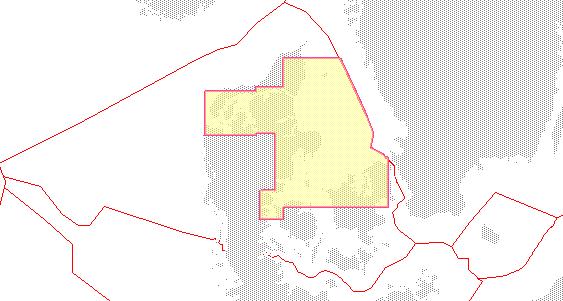
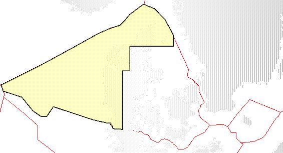
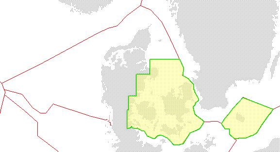

11 Geographic coverage (suggested folios) 3 predefined areas plus all of Denmark
12 IHO standard: S52 cartography

13 New possibilities for the distributors AIS data Weather data
14 Subscription period and pricing Subscription period Suggested retail price per area Wholesale price With approval (60%) Wholesale price Without approval (70%) Suggested retail price Denmark (3 areas) Wholesale price Wholesale price With approval (60%) Without approval (70%) 1 month Kr. 100 (200x 0.5) Kr. 60 (60%) Kr. 70 (70%) Kr. 300 (200x 1.5) Kr. 180 (60%) Kr. 210 (70%) 3 months Kr. 200 Kr. 120 (60%) Kr. 140 (70%) kr. 500 (200x 2.5) Kr. 300 (60%) Kr. 350 (70%) 6 months Kr. 400 (200x 2) Kr. 240 (60%) Kr. 280 (70%) Kr. 900 (200x4.5) Kr. 540 (60%) Kr. 630 (70%) 1 year Kr. 500 (200x 2,5) Kr. 300 (60%) Kr. 350 (70%) Kr (200x 5) Kr. 600 (60%) Kr. 700 (70%) * Suggested retail prices excluding taxes Kr. 200 (1 area for 3 months) is the proposed base factor DGA wholesale price = 70% of suggested retail price without product approval from accredited notified body DGA wholesale price = 60% of suggested retail price with product approval from accredited notified body
15 Distributor benefits Be a part of the solution to enhance safety at sea Official product allowed as primary navigational aid Weekly S-57 data updates available from DGA Acknowledgement as distributor from DGA website Add additional information such as weather, AIS, etc. Mutual promotional launch activities More efficient administration procedures New ENC data available (over 200 Danish harbours added) Ready for similar initiatives from other countries
16 Way forward Provide feedback to DGA Test data Beta product New contract Termination of current contracts and 2-year transitional period Launch of official ENC service Promotional activities
17 Draft overview of our maritime products Segment 1 Segment 2 Segment 3 Users SOLAS ships, Commercial ships, Segment 2 and 3 Leisure crafts (below 24 meters) For non navigation Digital data ENC provided by IC-ENC VAR and ECDIS New ENC service provided by certified distributors Digital data provided by GST Analog data Official paper charts provided by GST and UKHO Official paper charts for the leisure market provided by certified distributors -
NHC 59th meeting Agenda item NHC59-9A April 14-15, 2015 Reykjavik - Iceland. New national ENC service for leisure craft users
 NHC 59th meeting Agenda item NHC59-9A April 14-15, 2015 Reykjavik - Iceland New national ENC service for leisure craft users The aim of the new ENC service The aim of the new ENC service is to enhance
63rd Meeting of the Nordic Hydrographic Commission Meeting 9 11 April 2019, Helsinki, Finland
 Agenda item D4. Denmark 63rd Meeting of the Nordic Hydrographic Commission Meeting 9 11 April 2019, Helsinki, Finland Paper for Consideration by NHC63 Digital products for the leisure market 1. Introduction
Appendix: References and glossary
 Appendix: References and glossary Facts about electronic charts and carriage requirements 2nd edition 2007 V/1 CONTENTS OF SECTION 5 Appendix: References and glossary References...................................................
56 th NHC Meeting May 21-23, 2012 Copenhagen, Denmark. Draft Minutes. [May 23, 2012]
![56 th NHC Meeting May 21-23, 2012 Copenhagen, Denmark. Draft Minutes. [May 23, 2012]](/thumbs/91/107654306.jpg "56 th NHC Meeting May 21-23, 2012 Copenhagen, Denmark. Draft Minutes. [May 23, 2012]") NHC/56 Draft Minutes 56 th NHC Meeting May 21-23, 2012 Copenhagen, Denmark Draft Minutes [May 23, 2012] Venue: Chair: Secretary: Participants: The Danish Royal Academy of Sciences and Letters, Klasseværelset
NHC/56 Draft Minutes 56 th NHC Meeting May 21-23, 2012 Copenhagen, Denmark Draft Minutes [May 23, 2012] Venue: Chair: Secretary: Participants: The Danish Royal Academy of Sciences and Letters, Klasseværelset
MBSHC (Mediterranean and Black Seas Hydrographic Commission) XVII. conference, Greece Jun. 2011
 XVII. conference, Greece Jun. 2011") MBSHC (Mediterranean and Black Seas Hydrographic Commission) XVII. conference, Greece 01. 03. Jun. 2011 National report of SLOVENIA 01. May 2011 MBSHC report - SLOVENIA 1 0 Index 0 Index... 2 1 Hydrographic
MBSHC (Mediterranean and Black Seas Hydrographic Commission) XVII. conference, Greece 01. 03. Jun. 2011 National report of SLOVENIA 01. May 2011 MBSHC report - SLOVENIA 1 0 Index 0 Index... 2 1 Hydrographic
DEVELOPMENT OF A DEFINITION FOR MSPS AND CONSIDERATION FOR THE HARMONIZATION OF THE FORMAT AND STRUCTURE OF MSPS
 INTERNATIONAL HYDROGRAPHIC ORGANIZATION E IMO/IHO HARMONIZATION GROUP ON DATA MODELLING Agenda item 5 15 September 2017 ENGLISH ONLY DEVELOPMENT OF A DEFINITION FOR MSPS AND CONSIDERATION FOR THE HARMONIZATION
National Report of Finland
 National Report of Finland [31 August 2010] Executive Summary This Report gives an overview of the main activities of the Finnish Hydrographic Office (FHO) since the previous BSHC 14 th Conference. The
INTERNATIONAL STANDARD
 INTERNATIONAL STANDARD IEC 61174 Second edition 2001-10 Maritime navigation and radiocommunication equipment and systems Electronic chart display and information system (ECDIS) Operational and performance
The ship RV Timba repairs are now almost complete and it is expected that come September 2014 the ship will be fully operational.
 Malawi National Report 2014 1 Malawi Hydrographic Office The assembly of the 70 ton ship RV Timba with the assistance of the French government in 1989 ushered in the commencement of modern hydrographic
The human touch in technology. ECDIS ECS Conning screen Ship speed info system
 The human touch in technology ECDIS ECS Conning screen Ship speed info system Alphatron ALPHACHART T ECDIS Type approved ECDIS system powered by TRANSAS The ALPHACHART T is an advanced Electronic Chart
NEW ZEALAND CHARTING AND NOTICES TO MARINERS
 General Information 1. In accordance with agreements between New Zealand, Australia (AUS) and the British Admiralty (BA) for reducing duplication in charting activities, New Zealand has a defined Charting
UNITED KINGDOM NATIONAL REPORT
 UNITED KINGDOM NATIONAL REPORT TO THE 10 TH MACHC HYDROGRAPHIC COMMISSION MEETING Barbados 4 5 th November 2009 This report supplements the UK Generic National Report 2009, posted on the UKHO website (www.ukho.gov.uk),
e-navigation Progress and trends: the IHO perspective
 International Hydrographic Organization e-navigation Progress and trends: the IHO perspective Gilles Bessero Director, IHO International Hydrographic Organization Intergovernmental consultative and technical
MesoAmerican - Caribbean Sea Hydrographic Commission. International Hydrographic Organization DRAFT AGENDA DAY 1
 International Hydrographic Organization MesoAmerican-Caribbean Sea Hydrographic Commission DAY 1 DRAFT AGENDA MesoAmerican - Caribbean Sea Hydrographic Commission ELECTRONIC CHART WORKING GROUP MEETING
PRODUCTS AND SERVICES FOR THE MARITIME COMMUNITY. Ed Martin, Chief Customer Affairs Branch Navigation Services Division Monday, 27 October, 2008
 PRODUCTS AND SERVICES FOR THE MARITIME COMMUNITY Ed Martin, Chief Customer Affairs Branch Navigation Services Division Monday, 27 October, 2008 Coral Reef Conservation International Collaboration Marine
UNITED KINGDOM NATIONAL REPORT
 SAIHC12-5.3K UNITED KINGDOM NATIONAL REPORT 12 TH SOUTHERN AFRICA AND ISLANDS HYDROGRAPHIC COMMISSION (SAIHC) MEETING Dar es Salaam, Tanzania 22 nd 23 rd September 2015 This report supplements the UK Generic
Challenges and opportunities in the e-navigation Development. Actual projects.
 Challenges and opportunities in the e-navigation Development. Actual projects. John Erik Hagen, Regional Director Oslo, September 2018 What is e-navigation? Efficient transfer of marine information and
UNITED KINGDOM NATIONAL REPORT
 Page 1 of 9 UNITED KINGDOM NATIONAL REPORT TO THE 11 th MEETING OF THE MESO AMERICAN AND CARIBBEAN SEA HYDROGRAPHIC COMMISSION Paramaribo, Suriname 8 th 12 th November 2010 NOTE: This report supplements
PAPUA NEW GUINEA HYDROGRAPHIC SERVICE
 PAPUA NEW GUINEA HYDROGRAPHIC SERVICE IHO SOUTH WEST PACIFIC HYDROGRAPHIC COMMISSION (SWPHC) 9 th Meeting Port Moresby, Papua New Guinea, 10-11 March 2007 SWPHC9-01PNG 1. INTRODUCTION 9 th SOUTH WEST PACIFIC
EGYPTIAN HYDROGRAPHIC DEPARTMENT THE EGYPTIAN HYDROGRAPHIC FRAMEWORK
 gvt THE EGYPTIAN HYDROGRAPHIC FRAMEWORK The roles of a national Hydrographic Service can be summarized in collecting georeferenced data through systematic surveys at sea and along the coast related to:
GUIDELINES ON THE DESIGN AND USE OF PORTABLE PILOT UNITS INTERNATIONAL MARITIME PILOTS ASSOCIATION
 GUIDELINES ON THE DESIGN AND USE OF PORTABLE PILOT UNITS INTERNATIONAL MARITIME PILOTS ASSOCIATION WITH TECHNICAL INPUT FROM Comité International Radio-Maritime (CIRM) 2 FOREWORD With the increasing use
PROGRESS UPDATE AND FUTURE DIRECTIONS OF THE MARINE ELECTRONIC HIGHWAY (MEH)
") PROGRESS UPDATE AND FUTURE DIRECTIONS OF THE MARINE ELECTRONIC HIGHWAY (MEH) BACKGROUND 1. The Marine Electronic Highway Demonstration Project (MEH DP) was a 4- year regional project in the Straits of
PROGRESS UPDATE AND FUTURE DIRECTIONS OF THE MARINE ELECTRONIC HIGHWAY (MEH) BACKGROUND 1. The Marine Electronic Highway Demonstration Project (MEH DP) was a 4- year regional project in the Straits of
National Report of Finland
 National Report of Finland 1. Finnish Hydrographic Office The Finnish Hydrographic Office is organized under The Finnish Transport Agency. The Finnish Transport Agency is responsible for the Finnish roads,
Myanmar Naval Hydrographic Centre. National Report for 13 th North Indian Ocean Hydrographic Commission Meeting
 Myanmar Naval Hydrographic Centre National Report for 13 th North Indian Ocean Hydrographic Commission Meeting Yangon, Myanmar 19 th 22 nd February 2013 CONTENT 1. Myanmar Naval Hydrographic Centre 2.
A Survey of Mariners' Opinions on Using Electronic Charts
 s i l s Note A Survey of Mariners' Opinions on Using Electronic Charts Igor Karnicnik, M.Sc., Geodetic Institute of Slovenia, Slovenia. A new component of modern shipborne navigation equipment is the Electronic
GUIDANCE FOR THE PRESENTATION AND DISPLAY OF AIS APPLICATION-SPECIFIC MESSAGES INFORMATION
 E 4 ALBERT EMBANKMENT LONDON SE1 7SR Telephone: +44 (0)20 7735 7611 Fax: +44 (0)20 7587 3210 Ref. T2-OSS/2.7.1 SN.1/Circ.290 2 June 2010 GUIDANCE FOR THE PRESENTATION AND DISPLAY OF AIS APPLICATION-SPECIFIC
World-Wide Navigational Warning Service Sub-Committee WWNWS-5 Monaco, 1-4 October S-100 Basics Background Brief
 International Hydrographic Organization World-Wide Navigational Warning Service Sub-Committee WWNWS-5 Monaco, 1-4 October 2013 S-100 Basics Background Brief Gilles Bessero 15:29 1 S-100 Basics S-100 -
Korea s Strategy for e-navigation. SMART-Navigation. Presented by. Bu Young, Kim. 28 May Ministry of Oceans and Fisheries Republic of Korea
 Korea s Strategy for e-navigation SMART-Navigation Presented by Bu Young, Kim 28 May 2014 Ministry of Oceans and Fisheries Republic of Korea 1 2 3 4 5 6 1. SMART- Navigation? SMART-Navigation Korea s
The Present Status of Small Scale ENC Coverage with Respect to the Allocation of cells to Usage Bands 1 (Overview) and 2 (General).
 and 2 (General).") CHRIS19-06.1E 19 th CHRIS MEETING Rotterdam, Netherlands, 5-9 November 2007 The Present Status of Small Scale ENC Coverage with Respect to the Allocation of cells to Usage Bands 1 (Overview) and 2 (General).
CHRIS19-06.1E 19 th CHRIS MEETING Rotterdam, Netherlands, 5-9 November 2007 The Present Status of Small Scale ENC Coverage with Respect to the Allocation of cells to Usage Bands 1 (Overview) and 2 (General).
ROUTEING OF SHIPS, SHIP REPORTING AND RELATED MATTERS. New traffic separation schemes and two-way routes in Norra Kvarken
 E SUB-COMMITTEE ON SAFETY OF NAVIGATION 57th session Agenda item 3 NAV 57/3/7 11 March 2011 Original: ENGLISH ROUTEING OF SHIPS, SHIP REPORTING AND RELATED MATTERS New traffic separation schemes and two-way
MARINE ELECTRONIC HIGHWAY IN STRAITS OF MALACCA AND SINGAPORE. Development of Supporting Element for Future & Sustainable Operation
 COOPERATION FORUM UNDER THE COOPERATIVE MECHANISM ON SAFETY OF NAVIGATION AND ENVIRONMENTAL PROTECTION IN THE STRAITS OF MALACCA AND SINGAPORE 7th SESSION Agenda Item... CF 7/... 22-23 September 2014 Original.
UPDATING THE ELECTRONIC CHART THE SEATRANS PROJECT
 International Hydrographic Review, Monaco, LXV II(2), July 1990 UPDATING THE ELECTRONIC CHART THE SEATRANS PROJECT by Robert SANDVIK (*) Abstract As a follow-up of the North Sea Project, which called for
ECDIS ENC Accuracy. Contents. Introduction LOSS PREVENTION BRIEFING FOR NORTH MEMBER SHIPS / MAY Introduction... 1
 LOSS PREVENTION BRIEFING FOR NORTH MEMBER SHIPS / MAY 2017 ECDIS ENC Accuracy Contents Introduction... 1 ECDIS Specific Familiarisation... 2 IHO S-57... 2 ENC Data Source... 2 CATZOC and M_QUAL... 2 CATZOC
Digital broadcasting systems under development within ITU-R of interest for the maritime community
 Digital broadcasting systems under development within ITU-R of interest for the maritime community Christian RISSONE ANFR rissone@anfr.fr IHO, WWNWS 5 Monaco, 2 nd October 2013 1 Background for the 500
REGIONAL HYDROGRAPHIC COMMISSIONS CAPACITY BUILDING NSHC NHC BSHC USCHC USCHC EAtHC MBSHC RSAHC EAHC MACHC NIOHC SWPHC SEPHC (SWAtHC) SAIHC SWPHC HCA
 SAIHC SWPHC HCA") CONTENT THE VALUE of HYDROGRAPHIC INFORMATION and its INFLUENCE By THE INTERNATIONAL HYDROGRAPHIC ORGANIZATION I.II.III.IV.V.- INTRODUCTION HYDROGRAPHIC INFORMATION OF MAIN VALUE ACTIVITIES THAT BENEFIT
CONTENT THE VALUE of HYDROGRAPHIC INFORMATION and its INFLUENCE By THE INTERNATIONAL HYDROGRAPHIC ORGANIZATION I.II.III.IV.V.- INTRODUCTION HYDROGRAPHIC INFORMATION OF MAIN VALUE ACTIVITIES THAT BENEFIT
JCG GMDSS Symposium NAVDAT : Navigational Data
 JCG GMDSS Symposium 2013 NAVDAT : Navigational Data - System Presentation - Pascal OLIVIER NAVDAT Presentation Page 1/35 From analog to digital in maritime radio communications The current analog radio
The Pros and Cons of using ECDIS as Primary Means of Navigation
 Sections 1 2 Company introduction The PROS of Using ECDIS and ENCs 3 The CONS of Using ECDIS and ENCs 4 Why we have choose NAVTOR Company Introduction Corporate Overview. is a Ship Management Company established
Service instance description for the Baltic Navigational Warning Service
 Service instance description for the Baltic Navigational Warning Service 2018-01-18 Document status Authors Name Björn Andreasson Mikael Olofsson Organisation Swedish Maritime Administration Swedish Maritime
DRAFT ASSEMBLY RESOLUTION A. (26)
") DRAFT ASSEMBLY RESOLUTION A. (26) PROMULGATION OF MARITIME SAFETY INFORMATION The ASSEMBLY, RECALLING Article 15(j) of the Convention on the International Maritime Organization concerning the functions
DRAFT ASSEMBLY RESOLUTION A. (26) PROMULGATION OF MARITIME SAFETY INFORMATION The ASSEMBLY, RECALLING Article 15(j) of the Convention on the International Maritime Organization concerning the functions
IHO S-100 FRAMEWORK - BASELINE STANDARD FOR E- NAVIGATION MARITIME SERVICES
 UNDERWAY (24 26 January 2018) IHO S-100 FRAMEWORK - BASELINE STANDARD FOR E- NAVIGATION MARITIME SERVICES Abri Kampfer Director, IHO Copenhagen, Denmark (24 26 January 2018) What is the?. intergovernmental
RESOLUTION MSC.230(82) (adopted on 5 December 2006) ADOPTION OF AMENDMENTS TO THE EXISTING MANDATORY SHIP REPORTING SYSTEM "IN THE STOREBÆLT (GREAT
 (adopted on 5 December 2006) ADOPTION OF AMENDMENTS TO THE EXISTING MANDATORY SHIP REPORTING SYSTEM IN THE STOREBÆLT (GREAT") MSC 82/24/Add.2 RESOLUTION MSC.230(82) MANDATORY SHIP REPORTING SYSTEM IN THE STOREBÆLT (GREAT BELT) TRAFFIC AREA THE MARITIME SAFETY COMMITTEE, RECALLING Article 28(b) of the Convention on the International
MSC 82/24/Add.2 RESOLUTION MSC.230(82) MANDATORY SHIP REPORTING SYSTEM IN THE STOREBÆLT (GREAT BELT) TRAFFIC AREA THE MARITIME SAFETY COMMITTEE, RECALLING Article 28(b) of the Convention on the International
17 th CHRIS Meeting Rostock, Germany, 5-9 September Report of IHO-IEC Harmonization Group on Marine Information Objects (HGMIO
 17 th CHRIS Meeting Rostock, Germany, 5-9 September 2004 CHRIS17-7A rev.1 Report of IHO-IEC Harmonization Group on Marine Information Objects (HGMIO Lee Alexander, University of New Hampshire (Chair, HGMIO)
CLIA Member Experience Implementation of the Polar Code. Kierstin M. Del Valle February 22, 2018
 CLIA Member Experience Implementation of the Polar Code Kierstin M. Del Valle February 22, 2018 Overview Nature of operations General feedback Specific considerations Experience from V.Ships Leisure Next
Maritime Administration of Latvia (MAL) Hydrographic Service National Report to Baltic Sea Hydrographic Commission
 Hydrographic Service National Report to Baltic Sea Hydrographic Commission") Maritime Administration of Latvia (MAL) Hydrographic Service National Report to Baltic Sea Hydrographic Commission Executive summary 2016 The Report gives an overview of the main activities of Hydrographic
Maritime Administration of Latvia (MAL) Hydrographic Service National Report to Baltic Sea Hydrographic Commission Executive summary 2016 The Report gives an overview of the main activities of Hydrographic
INTERNATIONAL STANDARD
 INTERNATIONAL STANDARD IEC 61174 Edition 4.0 2015-08 colour inside Maritime navigation and radiocommunication equipment and systems Electronic chart display and information system (ECDIS) Operational and
USE OF THE RCDS MODE OF ECDIS (Submissions by Australia and Norway to IMO MSC/78)
") IHB File No. S3/8152 CIRCULAR LETTER 21/2004 22 March 2004 USE OF THE RCDS MODE OF ECDIS (Submissions by Australia and Norway to IMO MSC/78) Ref: 1. WEND Letter 1/2004, dated 1 st February 2004 2. IMO
IHB File No. S3/8152 CIRCULAR LETTER 21/2004 22 March 2004 USE OF THE RCDS MODE OF ECDIS (Submissions by Australia and Norway to IMO MSC/78) Ref: 1. WEND Letter 1/2004, dated 1 st February 2004 2. IMO
COMMUNICATIONS FOR MARITIME SAFETY AND EFFICIENCY. Francis Zachariae, Secretary-General, IALA
 COMMUNICATIONS FOR MARITIME SAFETY AND EFFICIENCY Francis Zachariae, Secretary-General, IALA IALA and its Purpose Non profit, international technical association established in 1957 Two Goals aimed at
NOAA s National Ocean Service / Office of Coast Survey
 Coast Survey OCS 1807 2007 Maintains over 1000 nautical charts & 9 Coast Pilots Surveys over 3.4M SNM of oceans and lakes Conducts research and development in hydrography Thomas Jefferson Founder of The
There is also need to acquire equipment such as GPS, Echo-Sounder and update data acquisition and processing software among other requirements.
 Malawi National Report 2016 1 Malawi Hydrographic Office The mandate of the Hydrographic office is to carry out surveys of Lake Malawi including the lesser lakes of Malombe, Chilwa and Chiuta as well as
IALA S WORK IN E-NAVIGATION. Michael Card
 IALA S WORK IN E-NAVIGATION Michael Card e-navigation origins The early work of IALA on e-navigation Multiple Initiatives EfficienSea 2 STM Validation IHO S-100 and IALA S-200 Smart Navigation VDES development
Paper for Consideration by S-100WG3. Report on S-100 Sea trial of KHOA
 S-100WG3-8.1 Paper for Consideration by S-100WG3 Report on S-100 Sea trial of KHOA Submitted by: Executive Summary: Related Documents: Related Projects: Republic of Korea (KHOA) This paper reports the
THE ELECTRONIC CHART DISPLAY AND INFORMATION SYSTEM (ECDIS) IN CHINA
 IN CHINA") International Hydrographic 'Review, Monaco, LXIX(2), September 1992 THE ELECTRONIC CHART DISPLAY AND INFORMATION SYSTEM (ECDIS) IN CHINA by The Research Group on ECDIS 1 Abstract This paper presents a
International Hydrographic 'Review, Monaco, LXIX(2), September 1992 THE ELECTRONIC CHART DISPLAY AND INFORMATION SYSTEM (ECDIS) IN CHINA by The Research Group on ECDIS 1 Abstract This paper presents a
Maritime Administration of Latvia Hydrographic Service National Report to Baltic Sea Hydrographic Commission
 Maritime Administration of Latvia Hydrographic Service National Report to Baltic Sea Hydrographic Commission Executive summary 2017 The Report gives an overview of the main activities of Hydrographic Service
IMO ACTIVITIES AFFECTING HSSC
 HSSC1-04.2A rev3 1 st HSSC MEETING Singapore, 22-24 October 2009 Paper for Consideration by HSSC IMO ACTIVITIES AFFECTING HSSC Submitted by: Executive Summary: Related Documents: IHB This paper summarizes
There has been some success
 Surveying Hydrography in Africa by Captain Abri Kampfer, Hydrographer SA Navy The International Hydrographic Bureau (IHB) and many member states of the International Hydrographic Organisation (IHO) have
CAPACITY BUILDING PLAN Programme document for the period
 INTERNATIONAL HYDROGRAPHIC ORGANIZATION MESO AMERICAN & CARIBBEAN SEA HYDROGRAPHIC COMMISSION 1. INTRODUCTION CAPACITY BUILDING PLAN Programme document for the period 2013-2017 1.1. Rationale It is estimated
1 st MEETING OF THE IHO COUNCIL
 C1-3.1 1 st MEETING OF THE IHO COUNCIL Monaco, 17-19 October 2017 REPORT OF THE IHO HYDROGRAPHIC SERVICES AND STANDARDS COMMITTEE C1-3.1 - P a g e 3 REPORT OF THE HYDROGRAPHIC STANDARDS AND SERVICES COMMITTEE
FOREWORD. IHO S-100 Working Group
 IHO International Hydrographic Organization KHOA Korea Hydrographic and Oceanographic Agency MUCH MORE THAN JUST NAUTICAL CHARTS IHO UNIVERSAL HYDROGRAPHIC data MODEL This document was produced with the
11 th CHRIS MEETING IHB, Monaco, November Draft - - -
 CHRIS/11/16A 11 th CHRIS MEETING IHB, Monaco, 16-18 November 1999 - - - Draft - - - Workshop on Development of Marine Information Objects (MIO) for ECDIS Burlington, Ontario, Canada 8-9 November 1999 Record
IMO RESOLUTION A.1001(25) Adopted on 29 November 2007 (Agenda item 9)
 Adopted on 29 November 2007 (Agenda item 9)") INTERNATIONAL MARITIME ORGANIZATION E IMO ASSEMBLY 25th session Agenda item 9 A 25/Res.1001 3 January 2008 Original: ENGLISH RESOLUTION A.1001(25) Adopted on 29 November 2007 (Agenda item 9) CRITERIA FOR
INTERNATIONAL MARITIME ORGANIZATION E IMO ASSEMBLY 25th session Agenda item 9 A 25/Res.1001 3 January 2008 Original: ENGLISH RESOLUTION A.1001(25) Adopted on 29 November 2007 (Agenda item 9) CRITERIA FOR
E-BOOK / MARITIME PLOTTING STUDY USER MANUAL
 27 December, 2017 E-BOOK / MARITIME PLOTTING STUDY USER MANUAL Document Filetype: PDF 435.34 KB 0 E-BOOK / MARITIME PLOTTING STUDY USER MANUAL National Open University of Nigeria University Village Plot
Outcome of the 1 st HELCOM Seminar on the use of AIS data
 Baltic Marine Environment Protection Commission 1 st HELCOM Seminar on the use of AIS data Helsinki, 9 May 2017 Outcome of the 1 st HELCOM Seminar on the use of AIS data Background... 2 Presentations...
RESOLUTION MSC.278(85) (adopted on 1 December 2008) ADOPTION OF THE NEW MANDATORY SHIP REPORTING SYSTEM "OFF THE COAST OF PORTUGAL - COPREP"
 (adopted on 1 December 2008) ADOPTION OF THE NEW MANDATORY SHIP REPORTING SYSTEM OFF THE COAST OF PORTUGAL - COPREP") MSC 85/26/Add.1 RESOLUTION MSC.278(85) SYSTEM OFF THE COAST OF PORTUGAL COPREP THE MARITIME SAFETY COMMITTEE, RECALLING Article 28 of the Convention on the International Maritime Organization concerning
MSC 85/26/Add.1 RESOLUTION MSC.278(85) SYSTEM OFF THE COAST OF PORTUGAL COPREP THE MARITIME SAFETY COMMITTEE, RECALLING Article 28 of the Convention on the International Maritime Organization concerning
This document describes the IMO e-navigation strategy and recommends a Danish strategy for e-navigation and associated action plan.
 Strategy and action plan for e-navigation This document describes the IMO e-navigation strategy and recommends a Danish strategy for e-navigation and associated action plan. Our reference: JKJ/MAF Case
MSI SELF ASSESSMENT - Baltic Sea Sub-area (BALTICO) of Navarea I, Submitted by Sweden
 of Navarea I, Submitted by Sweden") IHO Commission on the Promulgation of Radio Navigational Warnings (CPRNW) International Hydrographic Bureau, Monaco 11 14 Sep 2007 CPRNW 9-3.2.1-I-subarea Origin: Sweden MSI SELF ASSESSMENT - Baltic Sea
IHO Commission on the Promulgation of Radio Navigational Warnings (CPRNW) International Hydrographic Bureau, Monaco 11 14 Sep 2007 CPRNW 9-3.2.1-I-subarea Origin: Sweden MSI SELF ASSESSMENT - Baltic Sea
IHO Colours & Symbols Maintenance Working Group (C&SMWG) 15th Meeting, BSH, Rostock, Germany, 2-4 May 2005
 15th Meeting, BSH, Rostock, Germany, 2-4 May 2005") CSMWG15-INF2 IHO Colours & Symbols Maintenance Working Group (C&SMWG) 15th Meeting, BSH, Rostock, Germany, 2-4 May 2005 Ref: HA405/004/033-01 NOTE: this is an internal document of the UKHO and is supplied
CSMWG15-INF2 IHO Colours & Symbols Maintenance Working Group (C&SMWG) 15th Meeting, BSH, Rostock, Germany, 2-4 May 2005 Ref: HA405/004/033-01 NOTE: this is an internal document of the UKHO and is supplied
Production of Electronic Chart using updated survey data for EL-Arish harbor
 ARAB ACADEMY FOR SCIENCE AND TECHNOLOGY AND MARITIME TRANSPORT Alexandria, Egypt Production of Electronic Chart using updated survey data for EL-Arish harbor Submitted By ASHRAF NABIL HASSAN EL-ASSAL B.SC.
IMO. Resolution A.977(24) Adopted on 1 December 2005 (Agenda item 9) SHIPS ROUTEING
 Adopted on 1 December 2005 (Agenda item 9) SHIPS ROUTEING") INTERNATIONAL MARITIME ORGANIZATION E IMO ASSEMBLY 24th session Agenda item 9 A 24/Res.977 27 January 2006 Original: ENGLISH Resolution A.977(24) Adopted on 1 December 2005 (Agenda item 9) SHIPS ROUTEING
INTERNATIONAL MARITIME ORGANIZATION E IMO ASSEMBLY 24th session Agenda item 9 A 24/Res.977 27 January 2006 Original: ENGLISH Resolution A.977(24) Adopted on 1 December 2005 (Agenda item 9) SHIPS ROUTEING
Potential Markets for Electronic Charts
 Potential Markets for Electronic Charts Captain Evgeny Komrakov, Transas Marine Ltd Two main components are required before paper charts can be replaced on a ship's bridge with their digital equivalents.
AMENDMENTS TO RESOLUTION A.705(17) PROMULGATION OF MARITIME SAFETY INFORMATION
 PROMULGATION OF MARITIME SAFETY INFORMATION") E 4 ALBERT EMBANKMENT LONDON SE1 7SR Telephone: +44 (0)20 7735 7611 Fax: +44 (0)20 7587 3210 AMENDMENTS TO RESOLUTION A.705(17) PROMULGATION OF MARITIME SAFETY INFORMATION MSC.1/Circ.1287/Rev.1 24 June
E 4 ALBERT EMBANKMENT LONDON SE1 7SR Telephone: +44 (0)20 7735 7611 Fax: +44 (0)20 7587 3210 AMENDMENTS TO RESOLUTION A.705(17) PROMULGATION OF MARITIME SAFETY INFORMATION MSC.1/Circ.1287/Rev.1 24 June
SECTION III NM 40/17 MARINE INFORMATION
 SECTION III NM 40/17 MARINE INFORMATION NEW EDITION OF COAST PILOT U.S. Coast Pilot 4, Atlantic Coast: Cape Henry, VA to Key West, FL, forty-ninth edition, 2017, has been issued and is ready for free download
THE IHO, ELECTRONIC CHARTING AND THE CHANGING RELATIONSHIP TO PORTS
 International Hydrographic Review, Monaco, LXXI(2), September 1994 THE IHO, ELECTRONIC CHARTING AND THE CHANGING RELATIONSHIP TO PORTS by Rear Admiral Christian ANDREASEN1 (Presented at European Harbour
ROUTEING OF SHIPS, SHIP REPORTING AND RELATED MATTERS. Establishment of a Mandatory Ship Reporting System in the
 INTERNATIONAL MARITIME ORGANIZATION E SUB-COMMITTEE ON SAFETY OF NAVIGATION 48th session Agenda item 3 IMO NAV 48/3/2 11 April 2002 Original: ENGLISH ROUTEING OF SHIPS, SHIP REPORTING AND RELATED MATTERS
This circular summarizes the various important aspects of the LRIT system with a view to enabling companies to ensure compliance in a timely manner.
 Luxembourg, 29/10/2008 CIRCULAR CAM 02/2008 N/Réf. : AH/63353 Subject : Long-Range Identification and Tracking of Ships (LRIT) To : All ship owners, ship operators and designated persons of Luxembourg
UK Radio Interface Requirement 2020 for Radar 9 GHz (non-solas) in the maritime radionavigation service
 in the maritime radionavigation service") UK Radio Interface Requirement 2020 for Radar 9 GHz (non-solas) in the maritime radionavigation service (Version 1.0) 98/34/EC Notification Number: 2000/246/UK Published: 4 January 2001 Page 1 References
UK Radio Interface Requirement 2020 for Radar 9 GHz (non-solas) in the maritime radionavigation service (Version 1.0) 98/34/EC Notification Number: 2000/246/UK Published: 4 January 2001 Page 1 References
Draft submission paper: Hydrographic Offices way on EMODnet. Subject : Hydrographic Offices way on EMODnet. Foreword :
 Subject : Hydrographic Offices way on EMODnet Foreword : This paper is aimed to present the state of the EMODnet project, the European Commission s policy for this project, the principles of the Hydrographic
United States-Canada Hydrographic Commission (USCHC) Meeting
 Meeting") International Hydrographic Organization United States - Canada Hydrographic Commission International Hydrographic Organization (IHO) United States-Canada Hydrographic Commission (USCHC) Meeting 16 May
International Hydrographic Organization United States - Canada Hydrographic Commission International Hydrographic Organization (IHO) United States-Canada Hydrographic Commission (USCHC) Meeting 16 May
South African Distribution Code
 South African Distribution Code Metering Code Version 6.0 July 2014 This document is approved by the National Energy Regulator of South Africa (NERSA) Issued by: RSA Grid Code Secretariat Contact: Mr.
GENERAL DESCRIPTION OF THE CMC SERVICES
 STANDARD FOR CERTIFICATION No.1.1 GENERAL DESCRIPTION OF THE CMC SERVICES MAY 2007 FOREWORD (DNV) is an autonomous and independent foundation with the objectives of safeguarding life, property and the
... Salient Ocean Issues that have arisen during 2002
 ... As reported in paragraph 62 of the resolution Oceans and the law of the seas, we are especially pleased with the focus for this meeting, given that protecting vulnerable marine ecosystems and safety
Plan for Growth in the Danish Maritime Sector The Plan for Growth in the Danish Maritime Sectorcontains 37 initiatives.
 NOTE 18 January 2018 Facts about the Plan for Growth in the Danish Maritime Sector and the initiatives In May 2016, the Government established the Maritime Strategy Team, which was tasked with developing
Capability Statement VTS Simulator MSCN
 Capability Statement VTS Simulator MSCN Version 9.3, July 2006 M A R I N P.O. Box 28 6700 AA Wageningen The Netherlands T +31 317 49 39 11 F +31 317 49 32 45 E info@marin.nl I www.marin.nl Capability Statement
Policy Research Corporation
 Policy Research Corporation SOUND SOLUTIONS BASED ON SCIENTIFIC RESEARCH The role of Maritime Clusters to enhance the strength and development of maritime sectors Country report Denmark INTRODUCTION TO
TECHNICAL COMMITTEE 80: MARITIME NAVIGATION AND RADIOCOMMUNICATION EQUIPMENT AND SYSTEMS INTERNATIONAL ELECTROTECHNICAL COMMISSION
 TECHNICAL COMMITTEE 80: MARITIME NAVIGATION AND RADIOCOMMUNICATION EQUIPMENT AND SYSTEMS INTERNATIONAL ELECTROTECHNICAL COMMISSION IEC TECHNICAL COMMITTEE 80: MARITIME NAVIGATION AND RADIOCOMMUNICATION
Satellite technology to prevent and respond in cases of maritime accidents
 United Nations International Conference on Space-based Technologies for Disaster Management "Disaster risk identification, assessment and monitoring" 23-25 October 2013, Beijing, China. Satellite technology
Document code: 6/2/INF Date: Submitted by: Chairman DRAFT PROPOSAL FOR OPERATIONAL DEFINITIONS OF AIS COVERAGE.
 HELSINKI COMMISSION HELCOM AIS EWG 21/2010 Expert Working Group for Mutual Exchange and Deliveries of AIS data 21 st Meeting Gdynia, Poland, 27-28 October 2010 Agenda Item 6 Definition of AIS coverage
A guideline for establishing feature and symbol standard management system for national HOs
 A guideline for establishing feature and symbol standard management system for national HOs Joint 26th TSMAD and 5th DIPWG Meeting Silver Spring, Maryland, USA(10-14 June 2013) Republic of Korea (ROK)
Introductory remarks
 Introductory remarks This document is a draft of a permit for Gaz System to construct a natural gas pipeline on the Danish continental shelf in the Baltic Sea. It should be emphasised that it has not yet
E-Navigation: Opening the door to the future
 International Association of Marine Aids to Navigation and Lighthouse Authorities E-Navigation: Opening the door to the future E-Navigation Underway North America November 2018 Secretary-General Francis
NAUTICAL CHARTING IN SMALLER COUNTRIES WITH SHORT COASTLINE - TROUBLES AND ADVANTAGES
 NAUTICAL CHARTING IN SMALLER COUNTRIES WITH SHORT COASTLINE - TROUBLES AND ADVANTAGES Igor KARNICNIK, M.Sc. Dalibor RADOVAN (Geodetic Institute of Slovenia, Jamova 2, Ljubljana, Slovenia; igor.karnicnik@geod-is.si)
EUROPEAN COMMISSION DIRECTORATE-GENERAL FOR MOBILITY AND TRANSPORT PASSENGER SHIP SAFETY EXPERT SUB-GROUP
 EUROPEAN COMMISSION DIRECTORATE-GENERAL FOR MOBILITY AND TRANSPORT i Directorate D - Logistics, maritime & land transport and passenger rights D.2 - Maritime safety Brussels, MOVE D2 (2016) PASSENGER SHIP
NURTURING OFFSHORE WIND MARKETS GOOD PRACTICES FOR INTERNATIONAL STANDARDISATION
 NURTURING OFFSHORE WIND MARKETS GOOD PRACTICES FOR INTERNATIONAL STANDARDISATION Summary for POLICY MAKERS SUMMARY FOR POLICY MAKERS The fast pace of offshore wind development has resulted in remarkable
Human Rights Risk Tool for Seafood. Helen Duggan, Head of Responsible Sourcing, Seafish
 Human Rights Risk Tool for Seafood Helen Duggan, Head of Responsible Sourcing, Seafish Seafood Human Rights Risk Tool Collaboration to develop one risk assessment approach Identify and assess the risk
EU Ecolabel EMAS Environmental Technology Verification (ETV) State-of-play and evaluations
 State-of-play and evaluations") EU Ecolabel EMAS Environmental Technology Verification (ETV) State-of-play and evaluations Pierre Henry DG Environment B1 3 instruments of Circular Economy action plan Improving the efficiency and uptake
EU Ecolabel EMAS Environmental Technology Verification (ETV) State-of-play and evaluations Pierre Henry DG Environment B1 3 instruments of Circular Economy action plan Improving the efficiency and uptake
Western Region enavigation Sub- Committee Report
 Western Region enavigation Sub- Committee Report Western Region enavigation meeting - Jan 12 18 BC Ferries BC Coast Pilots BCIT Marine Campus Canadian Coast Guard Canadian Hydrographic Services Canadian
Radio Log Book. for Canadian Flag Vessels. 1 Master s Signature. Transports Canada. Transport Canada TP 13926E MARINE SAFETY
 Transport Canada MARINE SAFETY Transports Canada TP 13926E Radio Log Book for Canadian Flag Vessels Also for use on GMDSS exempted vessels Date Commenced Date Completed 1 Instructional Guide for Keeping
dkart Navigator 9010
 dkart Navigator 9010 dkart Navigator - purpose dkart Navigator is an electronic navigation chart system specially designed to facilitate all the navigational tasks of mariner's day-to-day practice. Along
Government Agency Perspectives & Initiatives Canadian Coast Guard Laurent Tardif, Director, Safe Shipping
 Unclassified Government Agency Perspectives & Initiatives Canadian Coast Guard Laurent Tardif, Director, Safe Shipping Mariner s Workshop January 23, 2019 1 Overview 1 Context 2 Marine Fees 3 4 5 Update
MARITIME SIMULATION SOLUTIONS TUG SIMULATORS
 MARITIME SIMULATION SOLUTIONS TUG SIMULATORS www.nautissim.com info@nautissim.com - 2 - NAUTIS - MARITIME SIMULATION SOLUTIONS BY VSTEP NAUTIS Simulators are DNV-GL accredited integrated simulator solutions
Joint - Jobs, Enterprise and Innovation. Opening Statement. Brian Hogan Marine Survey Office. Date: 21 September 2017
 Joint - Jobs, Enterprise and Innovation Opening Statement Brian Hogan Marine Survey Office Date: 21 September 2017 I thank the Chairman and Committee Members for inviting me here today. The issues which