NOAA s National Ocean Service / Office of Coast Survey
|
|
|
- Brice Morgan
- 6 years ago
- Views:
Transcription
1


2 Coast Survey OCS Maintains over 1000 nautical charts & 9 Coast Pilots Surveys over 3.4M SNM of oceans and lakes Conducts research and development in hydrography Thomas Jefferson Founder of The Coast Survey
3 Behind the Accuracy of Electronic Charts What Every Mariner Should Know about Electronic and Paper Charts
4


5 How we made paper charts yesterday is reflected in the accuracy of electronic charts today...
 computer hardware, 2)")
 and other")
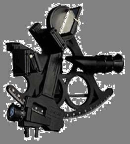
 software that")

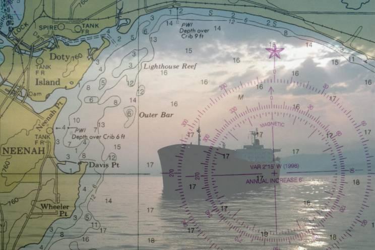
6 Electronic Chart Components OCS 1) computer hardware, 2) real-time positioning (typically GPS) and other sensors, 3) electronic chart data and 4) software that displays and manipulates both chart data and real-time sensor input.


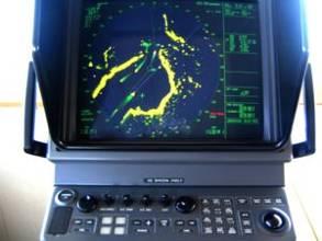
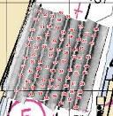
7 The Two Types of Electronic Charts Electronic Chart Display and Information System (ECDIS) Must comply with performance standards established by IMO. Standards specify components, features and functions of the ECDIS in which the primary purpose is to contribute to safe navigation. Electronic Chart System (ECS) Electronic Chart System (ECS) All other non-imo compliant systems.
 -- Show real-time vessel position projected on the chart image -- Impressive utility, but limited")
8 Two Categories of Electronic Chart Data Raster Nautical Charts -- Scanned image of the paper chart -- Used in Raster Chart Display Systems (type of ECS) -- Show real-time vessel position projected on the chart image -- Impressive utility, but limited ability

9 Two Categories of Electronic Chart Data Vector Chart -- A database that contains points, lines and polygons that correspond to chart features -- Data is intelligent -- Chart features can be attributed

10 Before the advent of GPS, chart makers were secure in the knowledge that the horizontal accuracy of features portrayed on a paper chart was more than adequate to serve the mariner s s needs.


11 25 years ago

12 The nautical charting world has been turned upside down in the past twenty years

13 The overall horizontal accuracy of data portrayed on paper charts s is a combination of the accuracy of the underlying source data and the chart compilation process. SOURCE USCG Aids to Navigation USACE Dredged channels NOAA Shoreline and non-channel depths OTHER USPS, USCGAux, Private Surveyors, etc. PRODUCTS Paper Charts Lithographic Print on Demand Raster Charts Update Service Vector Charts Electronic Navigational Charts

14 1994 NOS Survey 1:10, NOS Survey 1:40, NOS Survey Various NOS Survey Various

15 1800s positioning methods have changed over the years, but it s s still mast mounted GPS 2007 Sextant

16 Hydrographic Survey Over 50 percent of the depth information found on NOAA charts is based on hydrographic surveys conducted before 1940.


17 Pre Present Soundings obtained by hand lead-line line Soundings obtained by single-beam echo sounder Multi-beam Side Scan Sonar Soundings obtained by side scan sonar and multi-beam resulting in 100% bottom coverage All examples at the same line spacing

18 Early two-boat wire drag technique used to clear channels to a prescribed depth.


19 The shoreline found on most NOAA charts is based on photogrammetric or plane table surveys that are more than 20 years old.


20 Before NOAA s suite of charts was scanned into raster format in 1994, all chart compilation was performed manually.


21 In the late 1980's and early 1990's, NOAA converted all of its charts to NAD83 from NAD27.
22 Many electronic chart positional discrepancies that are observed today originate from graphical chart compilation techniques of the past.

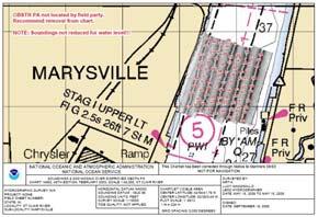
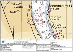
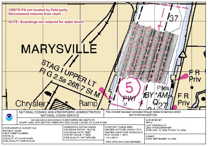
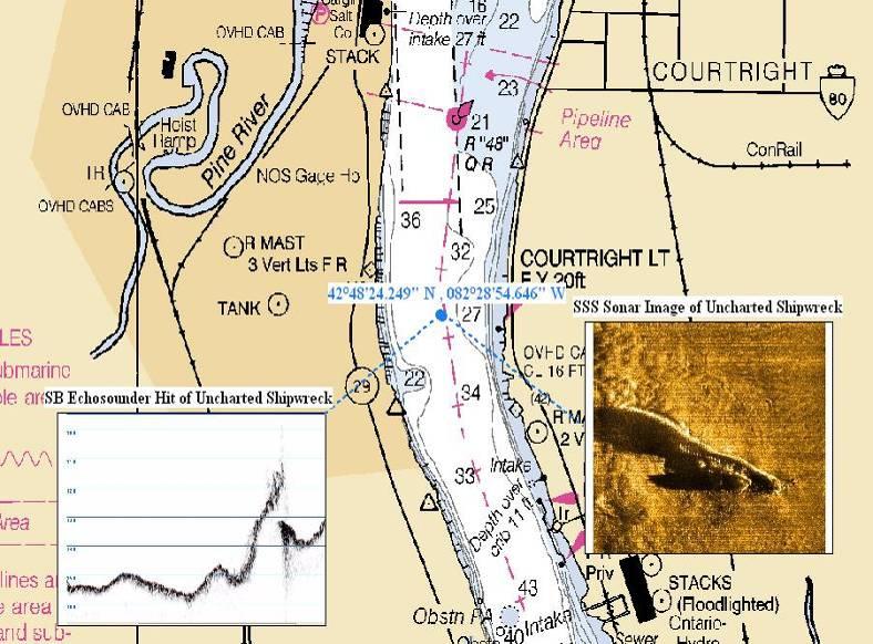
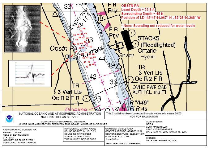
23 High accuracy aerial photography reveals similar discrepancies between the true shoreline and the charted shoreline.


24 Some mariners have the misconception that because charts can be viewed on a computer, the information displayed has somehow become more accurate than what appears on paper.
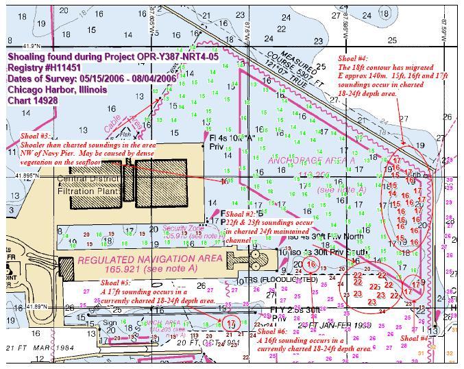
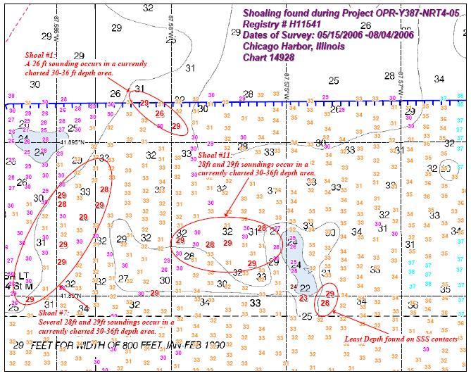
25 Addressing the Accuracy Problem A national suite of highly accurate electronic charts will be a primary cornerstone of a safe and efficient Marine Transportation System in the 21 st century.


26 NOAA is in the process of building a new charting database that will address some of the inadequacies of today s s electronic charts.


27 NOAA s approach to building ENCs addresses the horizontal accuracy issues.


28 Positions of all wrecks, obstructions and other hazards that appear on the chart are researched to obtain original positions. This data is then incorporated into the ENC. The remaining and less significant data is vectorized from the paper chart.


29 Over time, ENCs will be enhanced with higher accuracy data. Multi-beam Current 21 st Century Data Acquisition Digital USACE Survey

30 Ultimately, NOAA envisions printing the paper charts from the ENC database.


31 Mariners in the 21st century expect highly accurate electronic charts. NOAA is working toward that goal. Selectable Views Channel Fly-through Photorealistic Bottom Contours Charts of the Future?


32 Remember, when navigating with electronic charts in areas without navaids, give charted features such as rocks, wrecks, etc. as wide a berth as you did when navigating with a paper chart, the zoom capability does not make the object more accurately charted and continue using the wheelhouse windows.

33 Navigation Response Team (NRT)

34 Special Project completed - Single-beam centerline survey of St. Marys River to produce datum step chart Special Project completed Shoal sounding and wreck survey in St. Clair River Main 2006 Project side scan sonar, single beam hydrography, and ENC Validation, vicinity of Chicago Special projects requested for surveys at Silver Bay and Marquette


35 1 1 St. Clair River Special Project Obstruction Disproval New Wreck Found Shoal Disproval Obstruction Verified 2 3 4
36
37

38
39


40 Chicago Harbor Survey
41 Print on Demand Definition: The use of large format plotters to print charts when ordered using up-to to-date digital files. Product Characteristics: OCS Up-to to-date with all Notice to Mariners when printed Water-resistant resistant and abrasion resistant Extra information outside the neatline in two varieties Enhanced colors Next day delivery Status: Officially recognized product meeting Federal carriage requirements Book Charts are not yet available Produced under contract for NOAA by

42 Chart Update Service Definition A weekly electronic file that updates a raster nautical chart or an ENC Product Characteristics All USCG, NIMA, CHS Notices applied every week Update file delivered by e or downloaded from the internet Automatic application of update to chart Old chart, new chart, and patch can be viewed Status NOAA in continual maintenance mode Technology developed, tested and in-place Available by subscription through CRADA partner OCS


43 Download Raster Charts And ENCs free on the Internet!
44 For More Information Contact: Brian Link NOAA Navigation Services Division 1431 Beach Street Muskegon, MI
45
PRODUCTS AND SERVICES FOR THE MARITIME COMMUNITY. Ed Martin, Chief Customer Affairs Branch Navigation Services Division Monday, 27 October, 2008
 PRODUCTS AND SERVICES FOR THE MARITIME COMMUNITY Ed Martin, Chief Customer Affairs Branch Navigation Services Division Monday, 27 October, 2008 Coral Reef Conservation International Collaboration Marine
SECTION III NM 24/15 MARINE INFORMATION
 SECTION III NM 24/15 MARINE INFORMATION NATIONAL GEOSPATIAL-INTELLIGENCE AGENCY'S (NGA) GUIDANCE ON THE PROPER DISPLAY SCALE OF DIGITAL NAUTICAL CHART (DNC) DATA The DNC portfolio was originally created
United States - Canada Hydrographic Commission Halifax, Canada May 16, 2016
 United States - Canada Hydrographic Commission Halifax, Canada May 16, 2016 USCHC39 INF-E NOAA Pilot Study Applying Satellite-Derived Bathymetry to Longboat Pass, Florida Submitted by: The United States
SECTION III NM 34/14 MARINE INFORMATION
 MARINE INFORMATION AREAS TO BE AVOIDED (OCEANOGRAPHIC MOORINGS) IN THE EQUATORIAL PACIFIC OCEAN The National Oceanic and Atmospheric Administration (NOAA) maintains various buoys in the Equatorial Pacific
BookletChart. Sacramento River Sacramento to Fourmile Bend NOAA Chart A reduced-scale NOAA nautical chart for small boaters
 BookletChart Sacramento River Sacramento to Fourmile Bend NOAA Chart 18664 A reduced-scale NOAA nautical chart for small boaters When possible, use the full-size NOAA chart for navigation. Included Area
BookletChart. Sacramento River Andrus Island to Sacramento NOAA Chart A reduced-scale NOAA nautical chart for small boaters
 BookletChart Sacramento River Andrus Island to Sacramento NOAA Chart 18662 A reduced-scale NOAA nautical chart for small boaters When possible, use the full-size NOAA chart for navigation. Included Area
SECTION III NM 17/15 MARINE INFORMATION
 SECTION III NM 17/15 MARINE INFORMATION NOAA CHART NEW EDITIONS AND THEIR AVAILABILITY NOAA produces nautical chart products to support Federal chart carriage requirements. These nautical charts are available
SECTION III NM 35/10 MARINE INFORMATION NOAA CHART NEW EDITIONS AND THEIR AVAILABILITY
 SECTION III NM 35/10 MARINE INFORMATION NOAA CHART NEW EDITIONS AND THEIR AVAILABILITY NOAA recognizes two paper nautical chart products: - the Print-on-Demand (POD) chart distributed by OceanGrafix (www.oceangrafix.com),
BookletChart. Intracoastal Waterway Grassy Key to Bahia Honda Key NOAA Chart A reduced-scale NOAA nautical chart for small boaters
 BookletChart Intracoastal Waterway Grassy Key to Bahia Honda Key NOAA Chart 11453 A reduced-scale NOAA nautical chart for small boaters When possible, use the full-size NOAA chart for navigation. Published
SECTION III NM 15/12 MARINE INFORMATION
 SECTION III NM 15/12 MARINE INFORMATION CHANGES TO BROADCAST OF WEATHER FORECASTS FOR THE OFFSHORE SOUTHWEST NORTH ATLANTIC, CARIBBEAN, AND GULF OF MEXICO Effective Tuesday April 03, 2012 at 2:00 pm Eastern
NOAA Navigation Services Update
 NOAA Navigation Services Update Captain Jim Crocker Chief, Navigation Services Division NOAA s More than Two Centuries of Service First U.S. gov t science agency President Thomas Jefferson created the
THE IHO, ELECTRONIC CHARTING AND THE CHANGING RELATIONSHIP TO PORTS
 International Hydrographic Review, Monaco, LXXI(2), September 1994 THE IHO, ELECTRONIC CHARTING AND THE CHANGING RELATIONSHIP TO PORTS by Rear Admiral Christian ANDREASEN1 (Presented at European Harbour
SECTION III NM 4/16 MARINE INFORMATION
 MARINE INFORMATION NOAA CHART NEW EDITIONS AND THEIR AVAILABILITY NOAA produces nautical chart products to support Federal chart carriage requirements. These nautical charts are available as Print on Demand
Old House Channel Bathymetric and Side Scan Survey
 FIELD RESEARCH FACILITY DUCK, NC Old House Channel Bathymetric and Side Scan Survey COASTAL AND HYDRAULICS LABORATORY FIELD DATA COLLECTION AND ANALYSIS BRANCH Michael Forte December 2009 View looking
BookletChart. Chesapeake Bay Pocomoke and Tangier Sounds NOAA Chart A reduced-scale NOAA nautical chart for small boaters
 BookletChart Chesapeake Bay Pocomoke and Tangier Sounds NOAA Chart 12228 A reduced-scale NOAA nautical chart for small boaters When possible, use the full-size NOAA chart for navigation. Published by the
Lake Borgne, Louisiana Debris Mapping
 Lake Borgne, Louisiana Debris Mapping Abstract Gary R. Davis, Paul L. Donaldson, Walter Simmons, Rebecca Quintal Science Applications International Corporation 221 Third Street Newport, RI 02840 USA Under
INGESTION OF JALBTCX ALB DATASET INTO NOAA'S CHART PRODUCTION
 INGESTION OF JALBTCX ALB DATASET INTO NOAA'S CHART PRODUCTION Shachak Pe eri (JHC/CCOM) and Gretchen Imahori (NOAA) OCS/MCD (NOAA): John Barber, Anthony Klemm, Julia Powell, Mike Brown and John Nyberg
If you are searching for the ebook by Atmospheric Administration, Mapping Agency, National Oceanic, National Imagery U.S. Chart No.
 U.S. Chart No. 1: Symbols, Abbreviations And Terms Used On Paper And Electronic Navigational Charts, 12th Edition By Atmospheric Administration, Mapping Agency, National Oceanic, National Imagery READ
Helping Build Your Capacity in Nautical Charting & Hydrography
 Helping Build Your Capacity in Nautical Charting & Hydrography Helping Chart your World Rajesh Alla Riyadh, Kingdom of Saudi Arabia 04-06 March 2013 Company Background Marine Services Capacity Building
SECTION III NM 41/14 MARINE INFORMATION
 MARINE INFORMATION NOAA CHART NEW EDITIONS AND THEIR AVAILABILITY NOAA recognizes two paper nautical chart products: Print-on-Demand (POD) and traditional paper charts. - Print-on-Demand (POD) charts are
The ship RV Timba repairs are now almost complete and it is expected that come September 2014 the ship will be fully operational.
 Malawi National Report 2014 1 Malawi Hydrographic Office The assembly of the 70 ton ship RV Timba with the assistance of the French government in 1989 ushered in the commencement of modern hydrographic
DOWNLOAD OR READ : THE NAUTICAL CHART PDF EBOOK EPUB MOBI
 DOWNLOAD OR READ : THE NAUTICAL CHART PDF EBOOK EPUB MOBI Page 1 Page 2 the nautical chart the nautical chart pdf the nautical chart NOAA ENCs (ENC): Vector files of chart features and available in S-57
SECTION III NM 40/17 MARINE INFORMATION
 SECTION III NM 40/17 MARINE INFORMATION NEW EDITION OF COAST PILOT U.S. Coast Pilot 4, Atlantic Coast: Cape Henry, VA to Key West, FL, forty-ninth edition, 2017, has been issued and is ready for free download
BookletChart. St. Joseph and Benton Harbor NOAA Chart A reduced-scale NOAA nautical chart for small boaters
 BookletChart St. Joseph and Benton Harbor NOAA Chart 14930 A reduced-scale NOAA nautical chart for small boaters When possible, use the full-size NOAA chart for navigation. Included Area Published by the
LT Matthew Forney, NOAA Navigation Manager Alaska Region Bering Strait MaritimeSymposium. Office of Coast Survey
 NOAA LT Matthew Forney, NOAA Navigation Manager Alaska Region Bering Strait MaritimeSymposium Who is Coast Survey? First science agency of the U.S. Formed in 1807 Responsible for surveying 3.4 million
EGYPTIAN HYDROGRAPHIC DEPARTMENT THE EGYPTIAN HYDROGRAPHIC FRAMEWORK
 gvt THE EGYPTIAN HYDROGRAPHIC FRAMEWORK The roles of a national Hydrographic Service can be summarized in collecting georeferenced data through systematic surveys at sea and along the coast related to:
SECTION III NM 50/12 MARINE INFORMATION NOAA CHART NEW EDITIONS AND THEIR AVAILABILITY
 SECTION III NM 50/12 MARINE INFORMATION NOAA CHART NEW EDITIONS AND THEIR AVAILABILITY NOAA recognizes two paper nautical chart products: - the Print-on-Demand (POD) chart distributed by OceanGrafix (www.oceangrafix.com),
GIS Applications in the Saudi Aramco Offshore Hydrographic Surveying Environment
 GIS Applications in the Saudi Aramco Offshore Hydrographic Surveying Environment Fahad Al-Amri & Dr. Kevin Gibson Hydrographic Survey Unit, Saudi Aramco Tel: 038807822 Mobile: 0504617872 fahad.amri@aramco.com
SECTION III NM 39/13 MARINE INFORMATION NGA CHART NEW EDITIONS AND THEIR AVAILABILITY
 SECTION III NM 39/13 MARINE INFORMATION NGA CHART NEW EDITIONS AND THEIR AVAILABILITY NGA standard nautical hardcopy chart products are made available and distributed by three different authorized methods:
ECDIS ENC Accuracy. Contents. Introduction LOSS PREVENTION BRIEFING FOR NORTH MEMBER SHIPS / MAY Introduction... 1
 LOSS PREVENTION BRIEFING FOR NORTH MEMBER SHIPS / MAY 2017 ECDIS ENC Accuracy Contents Introduction... 1 ECDIS Specific Familiarisation... 2 IHO S-57... 2 ENC Data Source... 2 CATZOC and M_QUAL... 2 CATZOC
Questionnaire about the Depiction of the Quality of the Data in Nautical Charts
 Questionnaire about the Depiction of the Quality of the Data in Nautical Charts Your answers to this questionnaire, to be returned to the UKHO (see details on last page), will remain anonymous unless you
The Normal Baseline. Dick Gent Law of the Sea Division UK Hydrographic Office
 The Normal Baseline Dick Gent Law of the Sea Division UK Hydrographic Office 2 The normal baseline for measuring the breadth of the territorial sea is the low water line along the coast as marked on large
There is also need to acquire equipment such as GPS, Echo-Sounder and update data acquisition and processing software among other requirements.
 Malawi National Report 2016 1 Malawi Hydrographic Office The mandate of the Hydrographic office is to carry out surveys of Lake Malawi including the lesser lakes of Malombe, Chilwa and Chiuta as well as
GLMTF November 18, 2014 Presentation
 GLMTF November 18, 2014 Presentation Michigan Security Network Founded by major corporations, industry leaders and leading universities in 2008 as a non-profit organization (501c6). MiSN mission is to
No FEBRUARY 2017 UNITED STATES OF AMERICA. Contents
 6 11 FEBRUARY 2017 UNITED STATES OF AMERICA Published Weekly by the National Geospatial-Intelligence Agency Prepared Jointly with the National Ocean Service and U.S. Coast Guard Contents Section I Chart
INTEGRATING BATHYMETRY, TOPOGRAPHY, AND SHORELINE, AND THE IMPORTANCE OF VERTICAL DATUMS
 INTEGRATING BATHYMETRY, TOPOGRAPHY, AND SHORELINE, AND THE IMPORTANCE OF VERTICAL DATUMS Bruce Parker, Dennis Milbert, Kurt Hess, and Stephen Gill National Ocean Service, NOAA 1315 East-West Highway Silver
SECTION III NM 32/13 MARINE INFORMATION NOAA CHART NEW EDITIONS AND THEIR AVAILABILITY
 MARINE INFORMATION NOAA CHART NEW EDITIONS AND THEIR AVAILABILITY NOAA recognizes two paper nautical chart products: Print-on-Demand (POD) and traditional paper charts. - Print-on-Demand (POD) charts are
Production of Electronic Chart using updated survey data for EL-Arish harbor
 ARAB ACADEMY FOR SCIENCE AND TECHNOLOGY AND MARITIME TRANSPORT Alexandria, Egypt Production of Electronic Chart using updated survey data for EL-Arish harbor Submitted By ASHRAF NABIL HASSAN EL-ASSAL B.SC.
VDatum and SBET to Improve Accuracy of NOAA s High-Resolution Bathymetry
 VDatum and SBET to Improve Accuracy of NOAA s High-Resolution Bathymetry US HYDRO 2007 Extended Abstract Author: Crescent H. Moegling CoAuthor: Steve Brodet Moegling HYDRO 2007 1 Introduction NOAA s Hydrographic
NATIONAL VDATUM -- THE IMPLEMENTATION OF A NATIONAL VERTICAL DATUM TRANSFORMATION DATABASE
 NATIONAL VDATUM -- THE IMPLEMENTATION OF A NATIONAL VERTICAL DATUM TRANSFORMATION DATABASE Bruce Parker, Dennis Milbert, Kurt Hess, and Stephen Gill National Ocean Service, NOAA The National Ocean Service
16 Chart 1 - Symbols, Abbreviations, and Terms. Nautical Charts. John C. Kelly, 2003
 16 Chart 1 - Symbols, Abbreviations, and Terms GENERAL A. Chart Number, Title, Marginal Notes B. Positions, Distances, Directions, Compass TOPOGRAPHY C. Natural Features D. Cultural Features E. Landmarks
The human touch in technology. ECDIS ECS Conning screen Ship speed info system
 The human touch in technology ECDIS ECS Conning screen Ship speed info system Alphatron ALPHACHART T ECDIS Type approved ECDIS system powered by TRANSAS The ALPHACHART T is an advanced Electronic Chart
NEW ZEALAND CHARTING AND NOTICES TO MARINERS
 General Information 1. In accordance with agreements between New Zealand, Australia (AUS) and the British Admiralty (BA) for reducing duplication in charting activities, New Zealand has a defined Charting
Navigation Systems Division
 Prevention Department Navigation Systems Division SCF - Small Craft Facility Updating NOAA - AUXILIARY PARTNERSHIP SCF Training Program Presented by members of the US Coast Guard Auxiliary Navigation Systems
Malawi National Report Malawi Hydrographic Office
 Malawi National Report 2013 1 Malawi Hydrographic Office The Malawi Hydrographic Office was started 30 years after the federal government hydrographic surveys. In the year 1989 the 70-ton ship RV Timba
MESOAMERICAN AND CARIBBEAN HYDROGRAPHIC COMMISSION 11 th Meeting, Paramaribo, Suriname, Novembro NATIONAL REPORT BRAZIL
 Page 1 of 5 MESOAMERICAN AND CARIBBEAN HYDROGRAPHIC COMMISSION 11 th Meeting, Paramaribo, Suriname, Novembro 8-12 2010 NATIONAL REPORT BRAZIL 1. Hydrographic Office / Service: Directorate of Hydrography
PAPUA NEW GUINEA HYDROGRAPHIC SERVICE
 PAPUA NEW GUINEA HYDROGRAPHIC SERVICE IHO SOUTH WEST PACIFIC HYDROGRAPHIC COMMISSION (SWPHC) 9 th Meeting Port Moresby, Papua New Guinea, 10-11 March 2007 SWPHC9-01PNG 1. INTRODUCTION 9 th SOUTH WEST PACIFIC
Myanmar Naval Hydrographic Centre. National Report for 13 th North Indian Ocean Hydrographic Commission Meeting
 Myanmar Naval Hydrographic Centre National Report for 13 th North Indian Ocean Hydrographic Commission Meeting Yangon, Myanmar 19 th 22 nd February 2013 CONTENT 1. Myanmar Naval Hydrographic Centre 2.
NEW ZEALAND NOTICES TO MARINERS
 NEW ZEALAND NOTICES TO MARINERS Notice NZ 133 133 Published fortnightly by the New Zealand Hydrographic Authority Crown Copyright 2018. All rights reserved. Permission is not required to make analogue
THE ELECTRONIC CHART DISPLAY AND INFORMATION SYSTEM (ECDIS) IN CHINA
 IN CHINA") International Hydrographic 'Review, Monaco, LXIX(2), September 1992 THE ELECTRONIC CHART DISPLAY AND INFORMATION SYSTEM (ECDIS) IN CHINA by The Research Group on ECDIS 1 Abstract This paper presents a
International Hydrographic 'Review, Monaco, LXIX(2), September 1992 THE ELECTRONIC CHART DISPLAY AND INFORMATION SYSTEM (ECDIS) IN CHINA by The Research Group on ECDIS 1 Abstract This paper presents a
IENC production at the Flemish Hydrography. HYDRO12, 15 th November 2012 Jasmine Dumollin
 IENC production at the Flemish Hydrography HYDRO12, 15 th November 2012 Jasmine Dumollin ENC versus Inland ENC Definition Inland ENC Database, standardized as to content, structure and format, for use
Paper for a communication at the U.S. Hydro 2003
 Paper for a communication at the U.S. Hydro 2003 A Student Initiated Hydrographic Survey in a Riverine Environment, The Pearl River 2002 Field Project Experience David Dodd, Stephan Howden, David Wells,
A guideline for establishing feature and symbol standard management system for national HOs
 A guideline for establishing feature and symbol standard management system for national HOs Joint 26th TSMAD and 5th DIPWG Meeting Silver Spring, Maryland, USA(10-14 June 2013) Republic of Korea (ROK)
THE DEVELOPMENT OF CHINESE CHART IN THE 20TH CENTURY AND THE PROSPECTS FOR THE 21ST CENTURY
 THE DEVELOPMENT OF CHINESE CHART IN THE 20TH CENTURY AND THE PROSPECTS FOR THE 21ST CENTURY Li Shujun Hydrography and Mapping Department, Dalian Naval Academy, Dalian, CHINA,116018 E-mail : gh78088@online.
MEDITERRANEAN AND BLACK SEAS HYDROGRAPHIC COMMISSION
 MEDITERRANEAN AND BLACK SEAS HYDROGRAPHIC COMMISSION XVIII CONFERENCE CONTRIBITION BY MALTA Istanbul, Turkey 25-27 September 2013 1 Item 1 Hydrographic Office Transport Malta is responsible for all transport
Nordic Hydrographic Commission 60th Conference - Stavanger - Norway April New national ENC service for leisure craft users
 Nordic Hydrographic Commission 60th Conference - Stavanger - Norway 11-13 April 2016 New national ENC service for leisure craft users New national ENC service for leisure craft users The aim of the new
e-navigation Underway International February 2016 Kilyong Kim(GMT Co., Ltd.) Co-author : Seojeong Lee(Korea Maritime and Ocean University)
 Co-author : Seojeong Lee(Korea Maritime and Ocean University)") e-navigation Underway International 2016 2-4 February 2016 Kilyong Kim(GMT Co., Ltd.) Co-author : Seojeong Lee(Korea Maritime and Ocean University) Eureka R&D project From Jan 2015 to Dec 2017 15 partners
e-navigation Underway International 2016 2-4 February 2016 Kilyong Kim(GMT Co., Ltd.) Co-author : Seojeong Lee(Korea Maritime and Ocean University) Eureka R&D project From Jan 2015 to Dec 2017 15 partners
GUIDANCE FOR THE PRESENTATION AND DISPLAY OF AIS APPLICATION-SPECIFIC MESSAGES INFORMATION
 E 4 ALBERT EMBANKMENT LONDON SE1 7SR Telephone: +44 (0)20 7735 7611 Fax: +44 (0)20 7587 3210 Ref. T2-OSS/2.7.1 SN.1/Circ.290 2 June 2010 GUIDANCE FOR THE PRESENTATION AND DISPLAY OF AIS APPLICATION-SPECIFIC
21st International Conference of The Coastal Society
 21st International Conference of The Coastal Society DEVELOPMENT OF A VERTICAL DATUM TRANSFORMATION TOOL AND A BATHYMETRIC/TOPOGRAPHIC DIGITAL ELEVATION MODEL FOR SOUTHERN CALIFORNIA Edward P. Myers, NOAA/NOS
Department of Marine Science The University of Southern Mississippi and
 Continuing Development of the FIG/ Approved Category A Master of Science Degree in Hydrographic Science Program at The University of Southern Mississippi David Dodd 1, Ken Barbor 2, Stephan Howden 1, Charles
Appendix A Lower Columbia River Chart Datum Modeling
 Appendix A Lower Columbia River Chart Datum Modeling David Evans and Associates, Inc. David Evans and Associates, Inc. 2801 SE Columbia Way, Ste. 130 Vancouver, WA 98661 (360) 314-3200 1.0 Vertical Datum
REGIONAL HYDROGRAPHIC COMMISSIONS CAPACITY BUILDING NSHC NHC BSHC USCHC USCHC EAtHC MBSHC RSAHC EAHC MACHC NIOHC SWPHC SEPHC (SWAtHC) SAIHC SWPHC HCA
 SAIHC SWPHC HCA") CONTENT THE VALUE of HYDROGRAPHIC INFORMATION and its INFLUENCE By THE INTERNATIONAL HYDROGRAPHIC ORGANIZATION I.II.III.IV.V.- INTRODUCTION HYDROGRAPHIC INFORMATION OF MAIN VALUE ACTIVITIES THAT BENEFIT
CONTENT THE VALUE of HYDROGRAPHIC INFORMATION and its INFLUENCE By THE INTERNATIONAL HYDROGRAPHIC ORGANIZATION I.II.III.IV.V.- INTRODUCTION HYDROGRAPHIC INFORMATION OF MAIN VALUE ACTIVITIES THAT BENEFIT
Recent Developments in NOAA s Real- Time Coastal Observing Systems for Safe and Efficient Maritime Transportation
 Recent Developments in NOAA s Real- Time Coastal Observing Systems for Safe and Efficient Maritime Transportation Rich Edwing, Director NOAA Center for Operational Oceanographic Products and Services CMTS
Vertical Control via GPS vs. Tide Gauges: A Pilot Study
 Vertical Control via GPS vs. Tide Gauges: A Pilot Study Rebecca Quintal, John Shannon Byrne, John Kiernan, Evan Robertson, Walter Simmons, Gary Davis, Paul Donaldson, Deborah Smith, Jason Infantino and
Corps Dredge Plan 2016 Emily Hughes Env Resources, USACE BUILDING STRONG
 Corps Dredge Plan 2016 Emily Hughes Env Resources, USACE Goodbye Jeff Richter!! Navigation/Operations USACE Goal/Mission: To maintain safe Navigation in Federal Channels using methods that are most (1)
seawater temperature charts and aquatic resources distribution charts. Moreover, by developing a GIS plotter that runs on a common Linux distribution,
 A development of GIS plotter for small fishing vessels running on common Linux Yukiya Saitoh Graduate School of Systems Information Science Future University Hakodate Hakodate, Japan g2109018@fun.ac.jp
NEW ZEALAND NOTICES TO MARINERS
 NEW ZEALAND NOTICES TO MARINERS Notices NZ 147-148 Published fortnightly by the New Zealand Hydrographic Authority Crown Copyright 2018. All rights reserved. Permission is not required to make analogue
United States-Canada Hydrographic Commission (USCHC) Meeting
 Meeting") International Hydrographic Organization United States - Canada Hydrographic Commission International Hydrographic Organization (IHO) United States-Canada Hydrographic Commission (USCHC) Meeting 16 May
International Hydrographic Organization United States - Canada Hydrographic Commission International Hydrographic Organization (IHO) United States-Canada Hydrographic Commission (USCHC) Meeting 16 May
PROVIDING KNOWLEDGE AND KNOWHOW... ANYTIME, ANYWHERE LIGHT LIST. Reference Materials. Digital Edition. Captain Robert L. Figular
 PROVIDING KNOWLEDGE AND KNOWHOW... ANYTIME, ANYWHERE LIGHT LIST Reference Materials Digital Edition Captain Robert L. Figular Page intentionally left blank LIGHT LIST Atlantic Coast of North America MLS
MAINTENANCE DREDGING, PORT OF ALASKA HYDROGRAPHIC SURVEY PRE_ _POA ANCHORAGE, ALASKA V-101 SHEET IDENTIFICATION.
 _FINAL.DWG /7/08 0:07 AM " = 00' 0-8 W9KB8C000 ANCEXP 7 May 08 /07/8 CONTRACT NO. W9KB-8-C-000 Engineers V-0 _FINAL.DWG /7/08 0:07 AM " = 00' 0-8 W9KB8C000 ANCEXP 7 May 08 /07/8 CONTRACT NO. W9KB-8-C-000
7. PERFORMING ORGANIZATION NAME(S) AND ADDRESS(ES) 11. PERFORMING ORGANIZATION
 AND ADDRESS(ES) 11. PERFORMING ORGANIZATION") REPORT AD-A283 072 - O34 W~ MIS cal Wi41,ron N. o@e 1.AENYUS NL Levbln)2. REPORT DATE 3. REPORT TYPE AND DATES COVERED 4.TILEAN seni8 August 1994 Scientific Paper ECDIS Test and Demonstration on the Mississippi
REPORT AD-A283 072 - O34 W~ MIS cal Wi41,ron N. o@e 1.AENYUS NL Levbln)2. REPORT DATE 3. REPORT TYPE AND DATES COVERED 4.TILEAN seni8 August 1994 Scientific Paper ECDIS Test and Demonstration on the Mississippi
No OCTOBER 2016 UNITED STATES OF AMERICA. Contents
 42 15 OCTOBER 2016 UNITED STATES OF AMERICA Published Weekly by the National Geospatial-Intelligence Agency Prepared Jointly with the National Ocean Service and U.S. Coast Guard Contents Section I Chart
Course Instructions. 3 Easy Steps to Complete the Course: 1.) Read the Course PDF Below.
 Read the Course PDF Below.") Course Instructions NOTE: The following pages contain a preview of the final exam. This final exam is identical to the final exam that you will take online after you purchase the course. After you purchase
Course Instructions NOTE: The following pages contain a preview of the final exam. This final exam is identical to the final exam that you will take online after you purchase the course. After you purchase
National Report of Finland
 National Report of Finland [31 August 2010] Executive Summary This Report gives an overview of the main activities of the Finnish Hydrographic Office (FHO) since the previous BSHC 14 th Conference. The
Steps Towards a True Crowd, Collecting Bathymetry via Electronic Navigation Systems
 Steps Towards a True Crowd, Collecting Bathymetry via Electronic Navigation Systems Authors Adam Reed, LT/NOAA. Assistant Coordinator, Integrated Oceans and Coastal Mapping, NOAA. adam.reed@noaa.gov NOAA
No DECEMBER 2012 UNITED STATES OF AMERICA. Contents
 49 8 DECEMBER 2012 UNITED STATES OF AMERICA Published Weekly by the National Geospatial-Intelligence Agency Prepared Jointly with the National Ocean Service and U.S. Coast Guard Contents Section I Chart
Low-budget Hydrography
 ARTICLE OPINIONS FROM DIFFERING BACKGROUNDS Low-budget Hydrography Low-budget Hydrography is the theme of this issue. Realising that different players in hydrography will have differing opinions on various
dkart Navigator 9010
 dkart Navigator 9010 dkart Navigator - purpose dkart Navigator is an electronic navigation chart system specially designed to facilitate all the navigational tasks of mariner's day-to-day practice. Along
FOR MORE INFORMATION ON GMDSS CONTACT:
 FOR MORE INFORMATION ON GMDSS CONTACT: Commanding Officer USCG Navigation Center, MS 7310, 7323 Telegraph Road, Alexandria, VA 20598-7310 Tel:1-703-313-5900 www.navcen.uscg.gov Commandant (CG-652) Spectrum
Benefits and Impacts to Nautical Charting by Adopting a New Reference Frame. Dr. Neil Weston Office of Coast Survey, NOAA
 Benefits and Impacts to Nautical Charting by Adopting a New Reference Frame Dr. Neil Weston Office of Coast Survey, NOAA Motivation for this study NOAA s National Geodetic Survey New geometric reference
A Survey of Mariners' Opinions on Using Electronic Charts
 s i l s Note A Survey of Mariners' Opinions on Using Electronic Charts Igor Karnicnik, M.Sc., Geodetic Institute of Slovenia, Slovenia. A new component of modern shipborne navigation equipment is the Electronic
IT'S YOUR TIME. BlueChart. g2 Vision HD
 IT'S YOUR TIME BlueChart g2 Vision HD Auto Guidance Garmin's patented Auto Guidance is now capable of providing routing guidance to virtually any accessible destination on the water. Auto Guidance provides
A Report On Tide Gauges In Singapore. 1 The Republic of Singapore is an island city-state situated at the southern tip of
 A Report On Tide Gauges In Singapore Introduction 1 The Republic of Singapore is an island city-state situated at the southern tip of Peninsula Malaysia, approximately 1 north of the equator. It consists
ECDIS and MANTADIGITAL. PLUS
 TM MANTADIGITAL ECDIS and PLUS 2011/2012 www.ecdisplus.com Introduction What is an ECDIS? ECDIS is an acronym for Electronic Chart Display and Information System. At its simplest, an ECDIS consists of
Appendix: References and glossary
 Appendix: References and glossary Facts about electronic charts and carriage requirements 2nd edition 2007 V/1 CONTENTS OF SECTION 5 Appendix: References and glossary References...................................................
Kordil Surveying & Engineering Services
 Kordil Surveying & Engineering Services About Kordil Kordil Surveying & Engineering Ltd. Co. in short Kordil is an all in one surveying company providing service from Turkey. Hydrography, Oceanography
... Salient Ocean Issues that have arisen during 2002
 ... As reported in paragraph 62 of the resolution Oceans and the law of the seas, we are especially pleased with the focus for this meeting, given that protecting vulnerable marine ecosystems and safety
Is the new technology safe for navigation in coastal waters and archipelagos?
 3.35.20 Is the new technology safe for navigation in coastal waters and archipelagos? As near misses not are reported we take a look at the groundings Combat boat CB 90 (mostly) Thank you Lars-Erik! ECS
Overview of Tides and Water Levels
 Overview of Tides and Water Levels www.tidesandcurrents.noaa.gov New Orleans, Baton Rouge, Lafayette, LA March 2009 Gerald Hovis, NOAA - National Ocean Service William Sweet, NOAA - National Ocean Service
SUMMARY: The Coast Guard is declaring Sea Area A1 in certain. areas off the coast of the United States based upon the
 DEPARTMENT OF HOMELAND SECURITY Coast Guard [Docket No. USCG-2015-0002] Declaration of Sea Area A1 ACTION: Notice. This document is scheduled to be published in the Federal Register on 01/20/2015 and available
Services Overview. Northeast Blueprint
 Services Overview 2D CAD Conversions Paper to CAD 2D CAD Conversions Construction Engineering / CAD Services Construction Markups Consultant Drawings Coordinated Drawings As -Builts Steel Structural Detailing
High precision hydrography The St. Lawrence River channel HD Bathymetry, Production, Distribution and Updating
 HYDRO12 Conference High precision hydrography The St. Lawrence River channel HD Bathymetry, Production, Distribution and Updating M. Journault, L. Maltais, and R. Sanfaçon Canadian Hydrographic Service
Instruction with Hands-on Practice: Creating a Bathymetric Database & Datum Conversion
 Instruction with Hands-on Practice: Creating a Bathymetric Database & Datum Conversion Tanya Beck Coastal and Hydraulics Laboratory Engineer Research and Development Center May 17, 2010 US Army Corps of
3D Port Creation & Simulator Builds
 3D Port Creation & Simulator Builds The technology has moved on so much, it s incredible that we can now create large and extremely accurate bespoke ports for shipping companies, and, more importantly
FROM THE FIELD SHEET TO THE COMPLETE DIGITAL WORKFLOW
 FROM THE FIELD SHEET TO THE COMPLETE DIGITAL WORKFLOW Martin Gurtner Swisstopo, Federal Office of Topography, CH-3084 Wabern, Switzerland, martin.gurtner@swisstopo.ch Abstract The Swiss Federal Office
Three-dimensional investigation of buried structures with multi-transducer parametric sub-bottom profiler as part of hydrographical applications
 Three-dimensional investigation of buried structures with multi-transducer parametric sub-bottom profiler as part Jens LOWAG, Germany, Dr. Jens WUNDERLICH, Germany, Peter HUEMBS, Germany Key words: parametric,
Cedar Bayou: Houston Ship Channel to U.S. Steel Dock
 Cedar Bayou: + + -.ft.ft + B A R B O U R S BC A + 2+ + 2+ + + 2 + 2 A + 2+ + + + + + + 'W 2 'N 'W 2 'N 2 2 2 2 2 2 2 2 2 2 2 + Cedar Bayou Channel Buoy 2 Light 2 + Cedar Bayou Channel Daybeacon 2+ Cedar
GUIDELINES ON THE DESIGN AND USE OF PORTABLE PILOT UNITS INTERNATIONAL MARITIME PILOTS ASSOCIATION
 GUIDELINES ON THE DESIGN AND USE OF PORTABLE PILOT UNITS INTERNATIONAL MARITIME PILOTS ASSOCIATION WITH TECHNICAL INPUT FROM Comité International Radio-Maritime (CIRM) 2 FOREWORD With the increasing use
BookletChart. Approaches to Cap-Haitien and Bahia de Monti Cristi NGA Chart A reduced-scale NGA nautical chart for small boaters
 BookletChart Approaches to Cap-Haitien and Bahia de Monti Cristi NGA Chart 26142 A reduced-scale NGA nautical chart for small boaters When possible, use the full-size NGA chart or Electronic Nautical Chart
DYNAMIC POSITIONING SIMULATORS
 MARITIME SIMULATION SOLUTIONS DYNAMIC POSITIONING SIMULATORS www.nautissim.com info@nautissim.com NAUTIS - MARITIME SIMULATION SOLUTIONS BY VSTEP VSTEP s NAUTIS Simulators are DNV certified integrated