Malawi National Report Malawi Hydrographic Office
|
|
|
- Polly Garrison
- 6 years ago
- Views:
Transcription
1 Malawi National Report Malawi Hydrographic Office The Malawi Hydrographic Office was started 30 years after the federal government hydrographic surveys. In the year 1989 the 70-ton ship RV Timba was assembled with assistance from the French government. An Atlas Deso 22 echo sounder was also procured during this time. The Hydrographic office objective was to carry out surveys of Lake Malawi including the lesser lakes of Malombe, Chilwa and Chiuta and also the Shire River. By the same token the French government aid included the training of one hydrographer at EPSHOM in Brest, France. The ship; RV Timba was fully functional thus equipped with crew members who could go on voyages at any time required. In 2001 the project Charting of Lake Malawi for the Safety of Navigation was embarked on funded by ICEIDA (Icelandic International Development Agency) and the Malawi Government using mostly modern equipment and software for data acquisition and processing. This project ended in Hydrographic Surveys Lake Malawi is the third largest lake in Africa and has an approximate area of 24000km 2.Since the launch of the charting of Lake Malawi for the Safety of Navigation project that was embarked in 2001, a substantial amount of bathymetric data has been acquired and several charts have been produced. Significant investment in equipment and modern software was instrumental in the production of charts. To date 40% of the total area has been surveyed. Problems Over the past years, the Hydrographic Office has met greater outstanding challenges in its endeavors. One such challenge is the breakdown of the ship s propulsion engine which brought idleness in the acquisition of survey data and other significant survey operations. One of the engines of the Research Vessel Timba broke down while carrying out survey operations for Lake Niassa on a joint operation (Malawi Mozambique ICEIDA Project in August 2005).The Malawi Government made commendable strides and tremendous efforts to repair the vessel by purchasing two C7 New Caterpillar Marine Diesel Engines from Barloworld Company. Developments to fully accomplish the maintenance work are at an advanced stage as engineers are timelessly working on the boat. In fact there are just a few activities and technicalities remaining to fully prepare the vessel for seaworthiness. By fully maintaining the vessel, the Hydrographic office shall be brought to life and most programmes shall take a new stance. On the other hand the office has been using the Racal DGPS receiver for quite a long time before it malfunctioned. There were signs of ageing of equipment. A better alternative of an up to date model could have been sourced inorder to replace the obsolete and malfunctioning equipment. Hydrographic Office lacks such a reliable and vital piece of GPS equipment. On a note of success, the Hydrographic Office procured a hydrographic launch. This was on its long term plans. The launch has replaced an old model and intended purposely to serve and outreach the surveying of coastal and shoal areas.
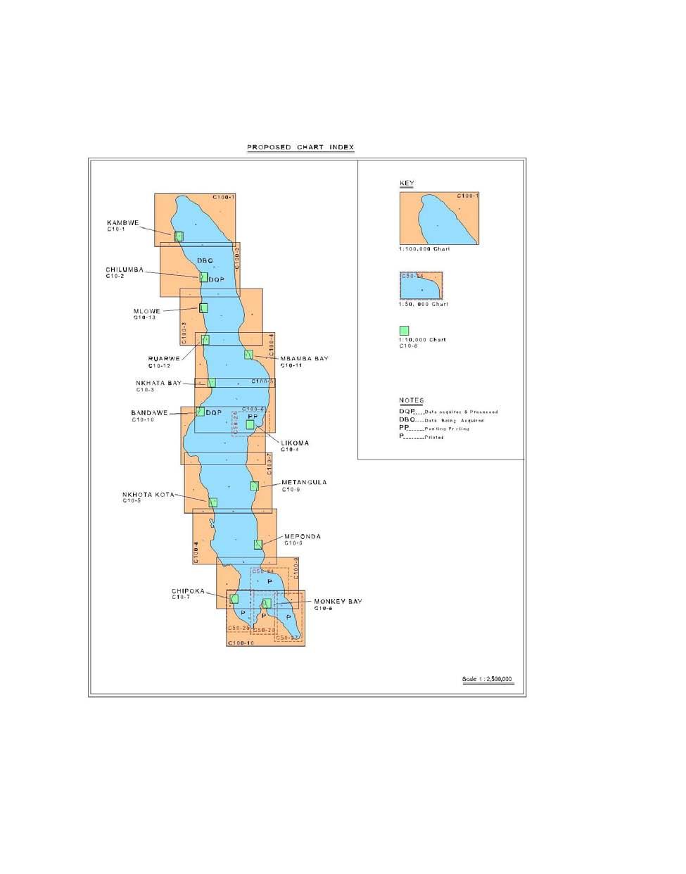
2 Without multi-beam echo sounder it is not possible to achieve 100% bottom coverage in harbor and critical areas however side scan sonar could assist if it is purchased as an interim measure. 3 New Charts & Updates Several new charts have been produced, these are: i. Data acquired - 1:100,000 Series a) C100-2 (50% of the data has been acquired) ii. Data acquired and validated - 1:10,000Series a. C10-4A b. C :100,000 Series C100-5 (few profiles to be redone in the field) iii. Charts ready for printing The following charts are ready for printing, and currently are printed on demand using CARIS Software: -1:10,000 Series C10-6B -1:50,000 Series a. C50-1B iv. Charts printed -1:10,000 Series a. C10-8 b. C :50,000Series c. C50-24 d. C50-25 e. C50-26 f. C50-27 The chart index is attached as Annex I.
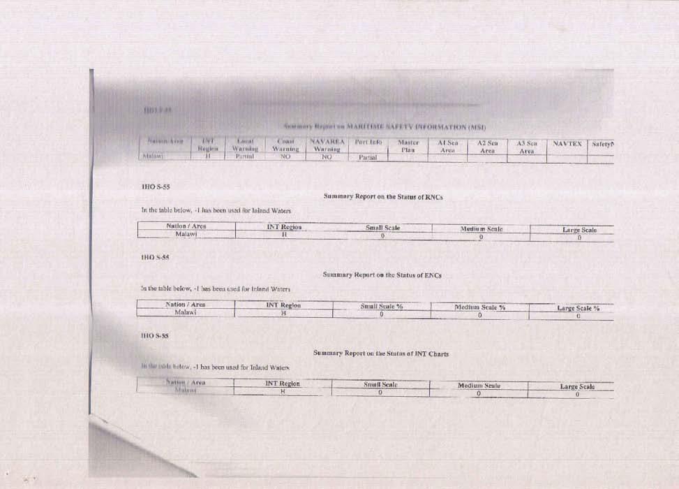
3 ENCs-the development of ENC is yet to be embarked on and should commence when resources and infrastructures become available. RNCs (Raster navigation Chart)-these can simply be produced by scanning at high resolution the original repromats. Not yet available at present. No INT and pleasure Craft Charts have been produced as yet. Problems Encountered Printing press is still not available. The department is looking into purchasing a printing press which is also required for production of new topographic maps that are currently outdated. A suggestion to print charts on demand has been made by SAIHC advisory team and also to use color fast and powder. 4. New Publications & Updates No new or updated publications have been made; however the work plan for 2012 included the proposal to embark on the revision of the Lake Malawi Pilot Book or Lake Malawi Sailing Direction. Due to inadequate funding this exercise did not take place and has therefore been included in this year s plans.. The Lake Malawi Sailing Directions will detail information about the coast and highlight dangers and show places of interest to tourism, for example. There will be close cooperation with the Department of Marine Services for this input. Problems encountered Lack of trained or experienced personnel in the preparation of the sailing pilot. It is hoped that once the Survey vessel Timba is back to sailing on the lake assistance shall be forthcoming to help with sailing pilot revision. 5. Maritime Safety Information (MSI) Nation/Area INT Region Local Warning Malawi H Partial Lake Malawi pilot update Coast Warning No Navarea Warning No Port Info Master Plan The transmission of safety information to Mariners is the responsibility of Marine Services Department. Problems Encountered Maritime Safety Information is not so well developed. Information on the weather is broadcasted on the local radio and television. Generally during the months of June to August, South Easterly winds are prevalent which blow up the length of the lake. This can go up to a week. The Marine Safety Channel (Channel 16) is a dedicated international channel for distress alert messages but is not obvious if most navigators use it effectively. However the marine administration has its own local radio channel which most mariners are able to access.
4 Maintenance of navigation lights is again the prerogative of the Marine Department. Some maintenance work is now being carried out. There are plans to replace the lights with robust ones, which are almost theft proof. All lights will be surveyed, coordinated and heighted. In addition other useful features and transit marks will be included in a new sailing directions. A system of notices to Mariners is not fully operational; this again awaits implementation by Marine Department. 6. C-55 The charts are at scales 1:10000, 1:50000 and 1: With the resources at hand the status of hydrography and nautical cartography may be ranked as fairly good. As mentioned above 40% of the lake has been surveyed. Two charts at 1:10000 and four charts at 1:50000 scales have been printed. One chart at 1:10000 and one at 1:50000 chart scales are being printed on demand. See attached Annex II (extracted from IHOCBC Malawi Visit Report 2008) 7. Capacity Building Achievements have been registered in the sense that surveys have been carried out and charts have been produced using the available personnel. However, it is obvious that they are no ready replacements for the staff. Thus more opportunities for training are still being sought in order to achieve continuity. Shortage of staff exists both in the hydrographic surveys and cartographic section. Staff recruitments have recently been managed as a means for covering up gaps and staff deficiencies. Government is making all efforts to maintain a trained staff and in this sense one staff member from the Hydrographic Office has now been trained at the STC in Netherlands which training was fully financed by the Malawi Government. Training is also sought for CAT A training in Hydrography. As of now a member of staff has completed a degree course in surveying and mapping at the university of Malawi, the Polytechnic. Training in Nautical Cartography is required especially in view of advances in automated Cartography. A course in Electronic Navigation Charting organized by the IMO was attended in Durban, South Africa. Similar courses of Data Design, Management and Marine Spatial Data infrastructure (MSDI) and Ports and Shallow Water Surveys have also been attended internationally. It is still hoped that the International community can look favorably once again on matters of training for our upcoming hydrographic concern so that they are equipped with new technological advancements. The cooperation between Malawi and Iceland brought with it such equipment as DGPS receiver, computer hardware and software, printers, plotter, scanner automated pressure tide gauge, sound velocity profiler and in data acquisition, Hypack data acquisition and processing software. In addition the CARIS chart processing software was a landmark towards achieving modern digital chart production capabilities. Formal multilateral agreement between Malawi, Mocambique and Iceland (ICEIDA) through Charting of Lake Malawi (Niassa) project has provided professional development whereby Malawian Hydrographers
5 interacted with the new data acquisition system i.e. RTK GPS and multibeam echo sounder. The survey work was completed in the year Our colleagues in Mozambique have now submitted two harbor charts of Metangula Bay and Meponda bay at 1/10,000 and 1/15,000 scale respectively which were done in conjunction with the Icelandic International Development Agency ICEIDA. Currently there is the joint project of the lake boundary between Malawi and Mozambique where funds have already been identified and the software to be use is the Caris Lots software. The project is just waiting for the completion of ship maintenance and to this aim funds have been set aside. The aim is to accurately determine the median line between Malawi and Mozambican waters in order to install floating marks / buoys for physical identification and reaffirmation of the lake border. Meanwhile there is also the Shire-Zambezi waterway project under study that will benefit Malawi as well as the SADC region in the shipping industry. We therefore await completion of a feasibility study in order to realize this navigation project. The study is yet to be carried out. 8. Oceanographic Activities A network of staff tide gauges running the whole stretch of the western coast of Lake Malawi including Lake Malombe and Shire River are maintained by the Ministry of Water and Irrigation department. One automated pressure tide gauge located at Monkey Bay Harbor was installed in 2001 and is maintained by the Malawi Hydrographic Unit. Proposed sites for additional automatic pressure tide gauges are at Nkhota Kota, Nkhata Bay and Chilumba ports and for this purpose plans are underway. A sound velocity profiler model 650 is used to calibrate the echo sounder. In case of failure of this equipment a bar check is used. For sediment sampling and description of the lake bottom characteristics, a Grab Corer was acquired and will soon be used as the winch motor is to be purchased with funding from GIZ Germany cooperation agency.. Problems encountered Lack of a current meter prevents the inclusion of water current information on the charts 10. Concluding Remarks Successes have been registered by the Malawi Hydrographic Unit, however a lot more still remains to be done in order for the HO to succeed in its endeavors of producing modern navigation charts, revising the Lake Malawi Pilot, providing a survey revision facility and monitoring services of the lake environment.
6 There is therefore need to invest in human resource and infrastructure development in order to overcome the problems mentioned above. To varying degree of success the Malawi government has made efforts to overcome these problems. Malawi completed port construction at the port of Nsanje in expectation of the Shire Zambezi waterway project and the Hydrographic offices both in Malawi and Mozambique will play prominent roles during the feasibility studies to give advice to various players. It is envisaged that the activities on the waterway will sustain the region surrounding this waterway in a significant manner in an area which is currently underdeveloped and faces various challenges, socioeconomic challenges which it is hoped will become a thing of the past once the project commences. We aim to model ourselves on other renowned and remarkable waterways in the world such as the Mississippi in the United States of America which is a viable example of integrated waterway management. The government of Malawi has shown commitment to its hydrographic endevours by purchasing and installing 2 new engines for the ship and carrying out major maintenance works on the hydro ship. Currently adequate funds have been set aside this year to finalise ship maintenance so that we can proceed with survey operations. There is also hope that the international community will come forward to give support to enable us to forge ahead in hydrographic surveying and charting of Lake Malawi which is to us our most significant natural resource harbouring a variety of endemic fish species and important economic needs of the country. In this sense Norway has already indicated a willingness to support Malawi once the ship Timba is back on sail. All concerned parties are very eager to bring the ship back to operations especially considering the dormant years of the ship which was necessitated by the breakdown of the ship engines.
7

8
9
The ship RV Timba repairs are now almost complete and it is expected that come September 2014 the ship will be fully operational.
 Malawi National Report 2014 1 Malawi Hydrographic Office The assembly of the 70 ton ship RV Timba with the assistance of the French government in 1989 ushered in the commencement of modern hydrographic
There is also need to acquire equipment such as GPS, Echo-Sounder and update data acquisition and processing software among other requirements.
 Malawi National Report 2016 1 Malawi Hydrographic Office The mandate of the Hydrographic office is to carry out surveys of Lake Malawi including the lesser lakes of Malombe, Chilwa and Chiuta as well as
Myanmar Naval Hydrographic Centre. National Report for 13 th North Indian Ocean Hydrographic Commission Meeting
 Myanmar Naval Hydrographic Centre National Report for 13 th North Indian Ocean Hydrographic Commission Meeting Yangon, Myanmar 19 th 22 nd February 2013 CONTENT 1. Myanmar Naval Hydrographic Centre 2.
EGYPTIAN HYDROGRAPHIC DEPARTMENT THE EGYPTIAN HYDROGRAPHIC FRAMEWORK
 gvt THE EGYPTIAN HYDROGRAPHIC FRAMEWORK The roles of a national Hydrographic Service can be summarized in collecting georeferenced data through systematic surveys at sea and along the coast related to:
MESOAMERICAN AND CARIBBEAN HYDROGRAPHIC COMMISSION 11 th Meeting, Paramaribo, Suriname, Novembro NATIONAL REPORT BRAZIL
 Page 1 of 5 MESOAMERICAN AND CARIBBEAN HYDROGRAPHIC COMMISSION 11 th Meeting, Paramaribo, Suriname, Novembro 8-12 2010 NATIONAL REPORT BRAZIL 1. Hydrographic Office / Service: Directorate of Hydrography
REPORT. Technical Visit THE ISLAMIC REPUBLIC OF IRAN February 2007
 REPORT Technical Visit to THE ISLAMIC REPUBLIC OF IRAN 20-22 February 2007 2 Technical Visit to the Islamic Republic of Iran (IHO Work Program 2007, Tasks 2.1.7 and 2.1.10) 20-22 February 2007 I.- General
National Report of Finland
 National Report of Finland [31 August 2010] Executive Summary This Report gives an overview of the main activities of the Finnish Hydrographic Office (FHO) since the previous BSHC 14 th Conference. The
Maritime Administration of Latvia Hydrographic Service National Report to Baltic Sea Hydrographic Commission
 Maritime Administration of Latvia Hydrographic Service National Report to Baltic Sea Hydrographic Commission Executive summary 2017 The Report gives an overview of the main activities of Hydrographic Service
NOAA s National Ocean Service / Office of Coast Survey
 Coast Survey OCS 1807 2007 Maintains over 1000 nautical charts & 9 Coast Pilots Surveys over 3.4M SNM of oceans and lakes Conducts research and development in hydrography Thomas Jefferson Founder of The
Maritime Administration of Latvia (MAL) Hydrographic Service National Report to Baltic Sea Hydrographic Commission
 Hydrographic Service National Report to Baltic Sea Hydrographic Commission") Maritime Administration of Latvia (MAL) Hydrographic Service National Report to Baltic Sea Hydrographic Commission Executive summary 2016 The Report gives an overview of the main activities of Hydrographic
Maritime Administration of Latvia (MAL) Hydrographic Service National Report to Baltic Sea Hydrographic Commission Executive summary 2016 The Report gives an overview of the main activities of Hydrographic
THE IHO, ELECTRONIC CHARTING AND THE CHANGING RELATIONSHIP TO PORTS
 International Hydrographic Review, Monaco, LXXI(2), September 1994 THE IHO, ELECTRONIC CHARTING AND THE CHANGING RELATIONSHIP TO PORTS by Rear Admiral Christian ANDREASEN1 (Presented at European Harbour
PAPUA NEW GUINEA HYDROGRAPHIC SERVICE
 PAPUA NEW GUINEA HYDROGRAPHIC SERVICE IHO SOUTH WEST PACIFIC HYDROGRAPHIC COMMISSION (SWPHC) 9 th Meeting Port Moresby, Papua New Guinea, 10-11 March 2007 SWPHC9-01PNG 1. INTRODUCTION 9 th SOUTH WEST PACIFIC
DRAFT ASSEMBLY RESOLUTION A. (26)
") DRAFT ASSEMBLY RESOLUTION A. (26) PROMULGATION OF MARITIME SAFETY INFORMATION The ASSEMBLY, RECALLING Article 15(j) of the Convention on the International Maritime Organization concerning the functions
DRAFT ASSEMBLY RESOLUTION A. (26) PROMULGATION OF MARITIME SAFETY INFORMATION The ASSEMBLY, RECALLING Article 15(j) of the Convention on the International Maritime Organization concerning the functions
DEVELOPMENT OF A DEFINITION FOR MSPS AND CONSIDERATION FOR THE HARMONIZATION OF THE FORMAT AND STRUCTURE OF MSPS
 INTERNATIONAL HYDROGRAPHIC ORGANIZATION E IMO/IHO HARMONIZATION GROUP ON DATA MODELLING Agenda item 5 15 September 2017 ENGLISH ONLY DEVELOPMENT OF A DEFINITION FOR MSPS AND CONSIDERATION FOR THE HARMONIZATION
MARITIME SAFETY INFORMATION
 Introduction 1. Maritime Safety Information (MSI) is defined as navigational and meteorological warnings, meteorological forecasts, and other urgent safety-related messages. This information is of vital
CAPACITY BUILDING PLAN Programme document for the period
 INTERNATIONAL HYDROGRAPHIC ORGANIZATION MESO AMERICAN & CARIBBEAN SEA HYDROGRAPHIC COMMISSION 1. INTRODUCTION CAPACITY BUILDING PLAN Programme document for the period 2013-2017 1.1. Rationale It is estimated
Helping Build Your Capacity in Nautical Charting & Hydrography
 Helping Build Your Capacity in Nautical Charting & Hydrography Helping Chart your World Rajesh Alla Riyadh, Kingdom of Saudi Arabia 04-06 March 2013 Company Background Marine Services Capacity Building
LT Matthew Forney, NOAA Navigation Manager Alaska Region Bering Strait MaritimeSymposium. Office of Coast Survey
 NOAA LT Matthew Forney, NOAA Navigation Manager Alaska Region Bering Strait MaritimeSymposium Who is Coast Survey? First science agency of the U.S. Formed in 1807 Responsible for surveying 3.4 million
e-navigation Progress and trends: the IHO perspective
 International Hydrographic Organization e-navigation Progress and trends: the IHO perspective Gilles Bessero Director, IHO International Hydrographic Organization Intergovernmental consultative and technical
PRODUCTS AND SERVICES FOR THE MARITIME COMMUNITY. Ed Martin, Chief Customer Affairs Branch Navigation Services Division Monday, 27 October, 2008
 PRODUCTS AND SERVICES FOR THE MARITIME COMMUNITY Ed Martin, Chief Customer Affairs Branch Navigation Services Division Monday, 27 October, 2008 Coral Reef Conservation International Collaboration Marine
AMENDMENTS TO RESOLUTION A.705(17) PROMULGATION OF MARITIME SAFETY INFORMATION
 PROMULGATION OF MARITIME SAFETY INFORMATION") E 4 ALBERT EMBANKMENT LONDON SE1 7SR Telephone: +44 (0)20 7735 7611 Fax: +44 (0)20 7587 3210 AMENDMENTS TO RESOLUTION A.705(17) PROMULGATION OF MARITIME SAFETY INFORMATION MSC.1/Circ.1287/Rev.1 24 June
E 4 ALBERT EMBANKMENT LONDON SE1 7SR Telephone: +44 (0)20 7735 7611 Fax: +44 (0)20 7587 3210 AMENDMENTS TO RESOLUTION A.705(17) PROMULGATION OF MARITIME SAFETY INFORMATION MSC.1/Circ.1287/Rev.1 24 June
APPLICATIONS OF KINEMATIC GPS AT SHOM
 International Hydrographic Review, Monaco, LXXVI(1), March 1999 APPLICATIONS OF KINEMATIC GPS AT SHOM by Michel EVEN 1 Abstract The GPS in kinematic mode has now been in use at SHOM for several years in
Kordil Surveying & Engineering Services
 Kordil Surveying & Engineering Services About Kordil Kordil Surveying & Engineering Ltd. Co. in short Kordil is an all in one surveying company providing service from Turkey. Hydrography, Oceanography
Related documents: None
 WWNWS WWNWS4/3/2/VII Meeting 4 23 August 2012 Agenda Item 3.2.VII 1 MSI Self Assessment NAVAREA VII Submitted by: South Africa SUMMARY Executive Summary: This document provides MSI information related
There has been some success
 Surveying Hydrography in Africa by Captain Abri Kampfer, Hydrographer SA Navy The International Hydrographic Bureau (IHB) and many member states of the International Hydrographic Organisation (IHO) have
RESOLUTION MSC.278(85) (adopted on 1 December 2008) ADOPTION OF THE NEW MANDATORY SHIP REPORTING SYSTEM "OFF THE COAST OF PORTUGAL - COPREP"
 (adopted on 1 December 2008) ADOPTION OF THE NEW MANDATORY SHIP REPORTING SYSTEM OFF THE COAST OF PORTUGAL - COPREP") MSC 85/26/Add.1 RESOLUTION MSC.278(85) SYSTEM OFF THE COAST OF PORTUGAL COPREP THE MARITIME SAFETY COMMITTEE, RECALLING Article 28 of the Convention on the International Maritime Organization concerning
MSC 85/26/Add.1 RESOLUTION MSC.278(85) SYSTEM OFF THE COAST OF PORTUGAL COPREP THE MARITIME SAFETY COMMITTEE, RECALLING Article 28 of the Convention on the International Maritime Organization concerning
GUIDANCE FOR THE PRESENTATION AND DISPLAY OF AIS APPLICATION-SPECIFIC MESSAGES INFORMATION
 E 4 ALBERT EMBANKMENT LONDON SE1 7SR Telephone: +44 (0)20 7735 7611 Fax: +44 (0)20 7587 3210 Ref. T2-OSS/2.7.1 SN.1/Circ.290 2 June 2010 GUIDANCE FOR THE PRESENTATION AND DISPLAY OF AIS APPLICATION-SPECIFIC
UNITED KINGDOM NATIONAL REPORT
 SAIHC12-5.3K UNITED KINGDOM NATIONAL REPORT 12 TH SOUTHERN AFRICA AND ISLANDS HYDROGRAPHIC COMMISSION (SAIHC) MEETING Dar es Salaam, Tanzania 22 nd 23 rd September 2015 This report supplements the UK Generic
A guideline for establishing feature and symbol standard management system for national HOs
 A guideline for establishing feature and symbol standard management system for national HOs Joint 26th TSMAD and 5th DIPWG Meeting Silver Spring, Maryland, USA(10-14 June 2013) Republic of Korea (ROK)
SPAIN NATIONAL REPORT/ ეროვნული ანგარიში.
 SPAIN NATIONAL REPORT/ ეროვნული ანგარიში http://www.armada.mde.es/ihm. 2 Index 1. Hydrographic Offices 2. Surveys 3. Charts and updates 4. Publications and updates 5. MSI 6. C-55 7. Capacity Building 8.
National Report of Finland
 National Report of Finland 1. Finnish Hydrographic Office The Finnish Hydrographic Office is organized under The Finnish Transport Agency. The Finnish Transport Agency is responsible for the Finnish roads,
DISC Ukrainian National Status Report
 DISC 2016 Ukrainian National Status Report NU OMA, prof.doct.tech Igor Gladkykh phone +380503909586 e-mail:gladkykh958@gmail.com Nick Golodov Hydrography Service of Ukraine phone +380444256874 e-mail:
NAUTICAL CHARTING IN SMALLER COUNTRIES WITH SHORT COASTLINE - TROUBLES AND ADVANTAGES
 NAUTICAL CHARTING IN SMALLER COUNTRIES WITH SHORT COASTLINE - TROUBLES AND ADVANTAGES Igor KARNICNIK, M.Sc. Dalibor RADOVAN (Geodetic Institute of Slovenia, Jamova 2, Ljubljana, Slovenia; igor.karnicnik@geod-is.si)
GLMTF November 18, 2014 Presentation
 GLMTF November 18, 2014 Presentation Michigan Security Network Founded by major corporations, industry leaders and leading universities in 2008 as a non-profit organization (501c6). MiSN mission is to
Object Detection for Underwater Port Security
 Object Detection for Underwater Port Security Dr. Lloyd Huff LCHUFF CONSULTANCY,LLC Mr. John Thomas TRITON IMAGING,INC Shallow Survey 2012 February 22, 2012 INTRODUCTION I am glad to be here today to make
BookletChart. Chesapeake Bay Pocomoke and Tangier Sounds NOAA Chart A reduced-scale NOAA nautical chart for small boaters
 BookletChart Chesapeake Bay Pocomoke and Tangier Sounds NOAA Chart 12228 A reduced-scale NOAA nautical chart for small boaters When possible, use the full-size NOAA chart for navigation. Published by the
OCEAN ECONOMY: SA - Norway PRESENTATION
 OCEAN ECONOMY: SA - Norway PRESENTATION PRESENTATION OUTLINE 1) Introduction: Ocean Economy 2) Introduction: Ocean Economy Focus Areas 3) Ocean Economy recommendations 4) Ocean Economy Focus Area Progress
Draft submission paper: Hydrographic Offices way on EMODnet. Subject : Hydrographic Offices way on EMODnet. Foreword :
 Subject : Hydrographic Offices way on EMODnet Foreword : This paper is aimed to present the state of the EMODnet project, the European Commission s policy for this project, the principles of the Hydrographic
AMENDMENTS TO RESOLUTION A.706(17) WORLD-WIDE NAVIGATIONAL WARNING SERVICE
 WORLD-WIDE NAVIGATIONAL WARNING SERVICE") E 4 ALBERT EMBANKMENT LONDON SE1 7SR Telephone: +44 (0)20 7735 7611 Fax: +44 (0)20 7587 3210 AMENDMENTS TO RESOLUTION A.706(17) WORLD-WIDE NAVIGATIONAL WARNING SERVICE MSC.1/Circ.1288/Rev.1 24 June 2013
E 4 ALBERT EMBANKMENT LONDON SE1 7SR Telephone: +44 (0)20 7735 7611 Fax: +44 (0)20 7587 3210 AMENDMENTS TO RESOLUTION A.706(17) WORLD-WIDE NAVIGATIONAL WARNING SERVICE MSC.1/Circ.1288/Rev.1 24 June 2013
56 th NHC Meeting May 21-23, 2012 Copenhagen, Denmark. Draft Minutes. [May 23, 2012]
![56 th NHC Meeting May 21-23, 2012 Copenhagen, Denmark. Draft Minutes. [May 23, 2012]](/thumbs/91/107654306.jpg "56 th NHC Meeting May 21-23, 2012 Copenhagen, Denmark. Draft Minutes. [May 23, 2012]") NHC/56 Draft Minutes 56 th NHC Meeting May 21-23, 2012 Copenhagen, Denmark Draft Minutes [May 23, 2012] Venue: Chair: Secretary: Participants: The Danish Royal Academy of Sciences and Letters, Klasseværelset
NHC/56 Draft Minutes 56 th NHC Meeting May 21-23, 2012 Copenhagen, Denmark Draft Minutes [May 23, 2012] Venue: Chair: Secretary: Participants: The Danish Royal Academy of Sciences and Letters, Klasseværelset
ECDIS ENC Accuracy. Contents. Introduction LOSS PREVENTION BRIEFING FOR NORTH MEMBER SHIPS / MAY Introduction... 1
 LOSS PREVENTION BRIEFING FOR NORTH MEMBER SHIPS / MAY 2017 ECDIS ENC Accuracy Contents Introduction... 1 ECDIS Specific Familiarisation... 2 IHO S-57... 2 ENC Data Source... 2 CATZOC and M_QUAL... 2 CATZOC
NAUTICAL CHARTS OF THE BRAZILIAN COAST FOR SMALL CRAFT
 International Hydrographic Review, Monaco, LXIX(2), September 1992 NAUTICAL CHARTS OF THE BRAZILIAN COAST FOR SMALL CRAFT by Eliana Fernandez LIRA 1and Fernando AMADEO 2 Abstract Brazil, a country of continental
Emerging Subsea Networks
 FIBRE-TO-PLATFORM CONNECTIVITY, WORKING IN THE 500m ZONE Andrew Lloyd (Global Marine Systems Limited) Email: andrew.lloyd@globalmarinesystems.com Global Marine Systems Ltd, New Saxon House, 1 Winsford
Nordic Hydrographic Commission 60th Conference - Stavanger - Norway April New national ENC service for leisure craft users
 Nordic Hydrographic Commission 60th Conference - Stavanger - Norway 11-13 April 2016 New national ENC service for leisure craft users New national ENC service for leisure craft users The aim of the new
Nautical tourism. J. Kasum 1, J. Žanić Mikuličić 2 & K. Božić Fredotović 3. Abstract. 1 Introduction
 Ravage of the Planet III 597 Nautical tourism J. Kasum 1, J. Žanić Mikuličić 2 & K. Božić Fredotović 3 1 Hydrographic Institute of the Republic of Croatia, Split, Croatia 2 Tourist Board of Municipality
BookletChart. Intracoastal Waterway Grassy Key to Bahia Honda Key NOAA Chart A reduced-scale NOAA nautical chart for small boaters
 BookletChart Intracoastal Waterway Grassy Key to Bahia Honda Key NOAA Chart 11453 A reduced-scale NOAA nautical chart for small boaters When possible, use the full-size NOAA chart for navigation. Published
MEDITERRANEAN AND BLACK SEAS HYDROGRAPHIC COMMISSION
 MEDITERRANEAN AND BLACK SEAS HYDROGRAPHIC COMMISSION XVIII CONFERENCE CONTRIBITION BY MALTA Istanbul, Turkey 25-27 September 2013 1 Item 1 Hydrographic Office Transport Malta is responsible for all transport
The Future in Marine Radio Communication GMDSS. Department of Transportation United States Coast Guard
 The Future in Marine Radio Communication GMDSS Department of Transportation United States Coast Guard Do you use a Maritime Radio System? If so, the new Global Maritime Distress and Safety System (GMDSS)
(P.27)
") (P.27) 27 7 210 120 8 * Navigation and Anchoring Prohibited Area has been changed since June, 2017. 9 Port of Osaka The Guidelines of Measures for preventing Typhoon Disaster ( Objective )
(P.27) 27 7 210 120 8 * Navigation and Anchoring Prohibited Area has been changed since June, 2017. 9 Port of Osaka The Guidelines of Measures for preventing Typhoon Disaster ( Objective )
BookletChart. Sacramento River Andrus Island to Sacramento NOAA Chart A reduced-scale NOAA nautical chart for small boaters
 BookletChart Sacramento River Andrus Island to Sacramento NOAA Chart 18662 A reduced-scale NOAA nautical chart for small boaters When possible, use the full-size NOAA chart for navigation. Included Area
BookletChart. Port-au-Prince (Haiti) NGA Chart A reduced-scale NGA nautical chart for small boaters
 NGA Chart A reduced-scale NGA nautical chart for small boaters") BookletChart Port-au-Prince (Haiti) NGA Chart 26186 A reduced-scale NGA nautical chart for small boaters When possible, use the full-size NGA chart or Electronic Nautical Chart (ENC) for navigation. VHF
BookletChart Port-au-Prince (Haiti) NGA Chart 26186 A reduced-scale NGA nautical chart for small boaters When possible, use the full-size NGA chart or Electronic Nautical Chart (ENC) for navigation. VHF
IMO/IHO World-wide Navigational Warning Service (WWNWS)
") IMO/IHO World-wide Navigational Warning Service (WWNWS) 1 WWNWS 1972 PROPOSAL TO SET UP AN Ad Hoc IHO/IMO COMMITTEE TO DEVELOP AN INTER- NATIONALLY CO-ORDINATED SYSTEM FOR PROMULGATING LONG RANGE NAVIGATIONAL
IMO/IHO World-wide Navigational Warning Service (WWNWS) 1 WWNWS 1972 PROPOSAL TO SET UP AN Ad Hoc IHO/IMO COMMITTEE TO DEVELOP AN INTER- NATIONALLY CO-ORDINATED SYSTEM FOR PROMULGATING LONG RANGE NAVIGATIONAL
This circular summarizes the various important aspects of the LRIT system with a view to enabling companies to ensure compliance in a timely manner.
 Luxembourg, 29/10/2008 CIRCULAR CAM 02/2008 N/Réf. : AH/63353 Subject : Long-Range Identification and Tracking of Ships (LRIT) To : All ship owners, ship operators and designated persons of Luxembourg
Standard Operating Procedures for: VHF Marine Radio
 Serenity Houseboat I. Overview Standard Operating Procedures for: VHF Marine Radio VHF, or Very High Frequency, marine radio is the standard method of communication between vessels. Marine radio equipment
WWNWS3/3/3/1A Meeting 3 1 August 2011 Agenda Item NAVTEX Panel Report SUMMARY
 WWNWS WWNWS3/3/3/1A Meeting 3 1 August 2011 Agenda Item 3.3.1 NAVTEX Panel Report Submitted by Chair, IMO International NAVTEX Co-ordinating Panel SUMMARY Executive Summary: This report provides a summary
MBSHC (Mediterranean and Black Seas Hydrographic Commission) XVII. conference, Greece Jun. 2011
 XVII. conference, Greece Jun. 2011") MBSHC (Mediterranean and Black Seas Hydrographic Commission) XVII. conference, Greece 01. 03. Jun. 2011 National report of SLOVENIA 01. May 2011 MBSHC report - SLOVENIA 1 0 Index 0 Index... 2 1 Hydrographic
MBSHC (Mediterranean and Black Seas Hydrographic Commission) XVII. conference, Greece 01. 03. Jun. 2011 National report of SLOVENIA 01. May 2011 MBSHC report - SLOVENIA 1 0 Index 0 Index... 2 1 Hydrographic
BookletChart. Approaches to Cap-Haitien and Bahia de Monti Cristi NGA Chart A reduced-scale NGA nautical chart for small boaters
 BookletChart Approaches to Cap-Haitien and Bahia de Monti Cristi NGA Chart 26142 A reduced-scale NGA nautical chart for small boaters When possible, use the full-size NGA chart or Electronic Nautical Chart
Digital broadcasting systems under development within ITU-R of interest for the maritime community
 Digital broadcasting systems under development within ITU-R of interest for the maritime community Christian RISSONE ANFR rissone@anfr.fr IHO, WWNWS 5 Monaco, 2 nd October 2013 1 Background for the 500
Baie de L Acul and Approaches (Haiti) NGA Chart A reduced-scale NGA nautical chart for small boaters
 NGA Chart A reduced-scale NGA nautical chart for small boaters") BookletChart Baie de L Acul and Approaches (Haiti) NGA Chart 26148 A reduced-scale NGA nautical chart for small boaters When possible, use the full-size NGA chart or Electronic Nautical Chart (ENC) for
BookletChart Baie de L Acul and Approaches (Haiti) NGA Chart 26148 A reduced-scale NGA nautical chart for small boaters When possible, use the full-size NGA chart or Electronic Nautical Chart (ENC) for
CPRNW. WWNWS9/3/3/3.2 Meeting 9 20 July 2017 Agenda Item Joint MET/NAVAREA XVII and XVIII Client Survey
 CPRNW WWNWS WWNWS9/3/3/3.2 Meeting 9 20 July 2017 Agenda Item 3.3.3.2 Joint MET/NAVAREA XVII and XVIII Client Survey Submitted by Canada, NAVAREA XVII_XVIII SUMMARY Executive Summary: This document describes
IHO Colours & Symbols Maintenance Working Group (C&SMWG) 15th Meeting, BSH, Rostock, Germany, 2-4 May 2005
 15th Meeting, BSH, Rostock, Germany, 2-4 May 2005") CSMWG15-INF2 IHO Colours & Symbols Maintenance Working Group (C&SMWG) 15th Meeting, BSH, Rostock, Germany, 2-4 May 2005 Ref: HA405/004/033-01 NOTE: this is an internal document of the UKHO and is supplied
CSMWG15-INF2 IHO Colours & Symbols Maintenance Working Group (C&SMWG) 15th Meeting, BSH, Rostock, Germany, 2-4 May 2005 Ref: HA405/004/033-01 NOTE: this is an internal document of the UKHO and is supplied
BookletChart. Sacramento River Sacramento to Fourmile Bend NOAA Chart A reduced-scale NOAA nautical chart for small boaters
 BookletChart Sacramento River Sacramento to Fourmile Bend NOAA Chart 18664 A reduced-scale NOAA nautical chart for small boaters When possible, use the full-size NOAA chart for navigation. Included Area
IENC production at the Flemish Hydrography. HYDRO12, 15 th November 2012 Jasmine Dumollin
 IENC production at the Flemish Hydrography HYDRO12, 15 th November 2012 Jasmine Dumollin ENC versus Inland ENC Definition Inland ENC Database, standardized as to content, structure and format, for use
IMO RESOLUTION A.1001(25) Adopted on 29 November 2007 (Agenda item 9)
 Adopted on 29 November 2007 (Agenda item 9)") INTERNATIONAL MARITIME ORGANIZATION E IMO ASSEMBLY 25th session Agenda item 9 A 25/Res.1001 3 January 2008 Original: ENGLISH RESOLUTION A.1001(25) Adopted on 29 November 2007 (Agenda item 9) CRITERIA FOR
INTERNATIONAL MARITIME ORGANIZATION E IMO ASSEMBLY 25th session Agenda item 9 A 25/Res.1001 3 January 2008 Original: ENGLISH RESOLUTION A.1001(25) Adopted on 29 November 2007 (Agenda item 9) CRITERIA FOR
02 Issue. e-navigation News. GNSS Vulnerability. Dublin Bay Digital Diamond. e-navigation. Demonstrator Update International. e-navigation.
 CORPORATE SECURITY TEAMWORK EVENTS 02 Issue e-navigation News GNSS Vulnerability Dublin Bay Digital Diamond e-navigation Demonstrator Update International e-navigation update June 2014 www.cil.ie +353
NEW ZEALAND NOTICES TO MARINERS
 NEW ZEALAND NOTICES TO MARINERS Notice NZ 133 133 Published fortnightly by the New Zealand Hydrographic Authority Crown Copyright 2018. All rights reserved. Permission is not required to make analogue
WWNWS9/3/2/XVII_XVIII Meeting 9 21 July 2017 Agenda Item 3.2. MSI Self Assessment NAVAREA XVII_XVIII. Submitted by Canada (Canadian Coast Guard)
") WWNWS WWNWS9/3/2/XVII_XVIII Meeting 9 21 July 2017 Agenda Item 3.2 MSI Self Assessment NAVAREA XVII_XVIII Submitted by Canada (Canadian Coast Guard) SUMMARY Executive Summary: Summary of activities within
WWNWS WWNWS9/3/2/XVII_XVIII Meeting 9 21 July 2017 Agenda Item 3.2 MSI Self Assessment NAVAREA XVII_XVIII Submitted by Canada (Canadian Coast Guard) SUMMARY Executive Summary: Summary of activities within
Passages Between Acklins Island, Haiti and Caicos Islands NGA Chart A reduced-scale NGA nautical chart for small boaters
 BookletChart Passages Between Acklins Island, Haiti and Caicos Islands NGA Chart 26260 A reduced-scale NGA nautical chart for small boaters When possible, use the full-size NGA chart or Electronic Nautical
Profile description of the Chair of Ports and Waterways
 Faculty Civil Engineering and Geosciences Department of Hydraulic Engineering Profile description of the Chair of Ports and Waterways 1. Position of the Chair of Ports and Waterways 1.1 Background With
1 st MEETING OF THE IHO COUNCIL
 C1-3.1 1 st MEETING OF THE IHO COUNCIL Monaco, 17-19 October 2017 REPORT OF THE IHO HYDROGRAPHIC SERVICES AND STANDARDS COMMITTEE C1-3.1 - P a g e 3 REPORT OF THE HYDROGRAPHIC STANDARDS AND SERVICES COMMITTEE
Meeting 10 8 August 2018 Agenda Item 2.1. MSI Self Assessment NAVAREA XVI. Submitted by PERÚ - DIRECTORATE OF HYDROGRAPHY AND NAVIGATION SUMMARY
 WWNWS10 WWNWS10/2/1-XVI Meeting 10 8 August 2018 Agenda Item 2.1 MSI Self Assessment NAVAREA XVI Submitted by PERÚ - DIRECTORATE OF HYDROGRAPHY AND NAVIGATION SUMMARY Executive Summary: Report of activities
Challenges and opportunities in the e-navigation Development. Actual projects.
 Challenges and opportunities in the e-navigation Development. Actual projects. John Erik Hagen, Regional Director Oslo, September 2018 What is e-navigation? Efficient transfer of marine information and
FOREWORD. IHO S-100 Working Group
 IHO International Hydrographic Organization KHOA Korea Hydrographic and Oceanographic Agency MUCH MORE THAN JUST NAUTICAL CHARTS IHO UNIVERSAL HYDROGRAPHIC data MODEL This document was produced with the
SPECIFICATION FOR TOPOGRAPHIC AND HYDROGRAPHIC SURVEYS OF RECLAMATION AND DREDGING WORKS
 23 August 2001 SPECIFICATION FOR TOPOGRAPHIC AND HYDROGRAPHIC SURVEYS OF RECLAMATION AND DREDGING WORKS 1.0 EXTENT OF WORKS The main survey works shall comprise of the following : a. Carry out topographic
MARINE ELECTRONIC HIGHWAY IN STRAITS OF MALACCA AND SINGAPORE. Development of Supporting Element for Future & Sustainable Operation
 COOPERATION FORUM UNDER THE COOPERATIVE MECHANISM ON SAFETY OF NAVIGATION AND ENVIRONMENTAL PROTECTION IN THE STRAITS OF MALACCA AND SINGAPORE 7th SESSION Agenda Item... CF 7/... 22-23 September 2014 Original.
Canadian Coast Guard Review to Implement a Resilient Position, Navigation and Timing Solution for Canada. Mariners Workshop January 31 st, 2018
 Canadian Coast Guard Review to Implement a Resilient Position, Navigation and Timing Solution for Canada Mariners Workshop January 31 st, 2018 Outline Overview of GNSS use in the marine sector CCG Activities
TOWARDS A COORDINATED INTERNATIONAL RADIO NAVIGATIONAL WARNINGS SYSTEM
 Internationa! Hydrographic Review, Monaco, LIVC1) January 1977. TOWARDS A COORDINATED INTERNATIONAL RADIO NAVIGATIONAL WARNINGS SYSTEM b y Captain Hans Sc h u m an n lately Head of the Nautical Publications
Combining low-cost sonar and high-precision GNSS for river and estuarine bathymetry
 Combining low-cost sonar and high-precision GNSS for river and estuarine bathymetry J.A. Gonçalves, J. Pinheiro, L. Bastos, A. Bio Background Bathymetry surveys are essential to provide data to keep navigation
Modernisation of the Hydrographic Service of Uruguay
 Note Modernisation of the Hydrographic Service of Uruguay By Capt. Hugo Roldos de la Sovera, Capt. Orestes Pereyra, Lt. Alvaro Sanchez and Lt Jose Dominguez, Servicio de Oceanografîa, Hidrografîa y Meteorologfa
Paper for Consideration by S-100WG3. Report on S-100 Sea trial of KHOA
 S-100WG3-8.1 Paper for Consideration by S-100WG3 Report on S-100 Sea trial of KHOA Submitted by: Executive Summary: Related Documents: Related Projects: Republic of Korea (KHOA) This paper reports the
Expanded use of Automatic Identification System (AIS) navigation technology in Vessel Traffic Services (VTS) B. J. Tetreault 1
 navigation technology in Vessel Traffic Services (VTS) B. J. Tetreault 1") Expanded use of Automatic Identification System (AIS) navigation technology in Vessel Traffic Services (VTS) B. J. Tetreault 1 1 (At time of writing) U. S. Coast Guard, Office of Shore Forces (CG-7413),
Expanded use of Automatic Identification System (AIS) navigation technology in Vessel Traffic Services (VTS) B. J. Tetreault 1 1 (At time of writing) U. S. Coast Guard, Office of Shore Forces (CG-7413),
... Salient Ocean Issues that have arisen during 2002
 ... As reported in paragraph 62 of the resolution Oceans and the law of the seas, we are especially pleased with the focus for this meeting, given that protecting vulnerable marine ecosystems and safety
PROGRESS UPDATE AND FUTURE DIRECTIONS OF THE MARINE ELECTRONIC HIGHWAY (MEH)
") PROGRESS UPDATE AND FUTURE DIRECTIONS OF THE MARINE ELECTRONIC HIGHWAY (MEH) BACKGROUND 1. The Marine Electronic Highway Demonstration Project (MEH DP) was a 4- year regional project in the Straits of
PROGRESS UPDATE AND FUTURE DIRECTIONS OF THE MARINE ELECTRONIC HIGHWAY (MEH) BACKGROUND 1. The Marine Electronic Highway Demonstration Project (MEH DP) was a 4- year regional project in the Straits of
SOUTH AFRICAN NAVY HYDROGRAPHIC OFFICE
 SOUTH AFRICAN NAVY HYDROGRAPHIC OFFICE GLOSS National Report for South Africa 2009 Compiled by Ms Ruth Farre Superintendent Tidal Information 1. Introduction The South African coastline is approximately
Tide & Meteorological Data over AIS
 Tide & Meteorological Data over AIS E.F.Read (Ohmex Ltd) & W.S.Heaps (ABP Ltd) THSUK Hydro8 1 Background to AIS Most significant development since RADAR Positions and Timing from GPS network 12.5 Watt
Western Region enavigation Sub- Committee Report
 Western Region enavigation Sub- Committee Report Western Region enavigation meeting - Jan 12 18 BC Ferries BC Coast Pilots BCIT Marine Campus Canadian Coast Guard Canadian Hydrographic Services Canadian
RULES FOR THE CONSTRUCTION AND CLASSIFICATION OF MOBILE OFFSHORE DRILLING UNITS TITLE MOBILE OFFSHORE DRILLING UNITS NAUTIC AND ELECTRONICS CHAPTERS
 PARTE II RULES FOR THE CONSTRUCTION AND CLASSIFICATION OF MOBILE OFFSHORE DRILLING UNITS TITLE MOBILE OFFSHORE DRILLING UNITS SECTION 8 NAUTIC AND ELECTRONICS CHAPTERS A B C D SCOPE TECHNICAL DOCUMENTATION
The Nordic Institute of Navigation (NNF)
") The Nordic Institute of Navigation (NNF) www.nornav.org non-profit, independent and a non-political organization for professionals working within the field of navigation. The focus of NNF is on all aspects
The Nordic Institute of Navigation (NNF) www.nornav.org non-profit, independent and a non-political organization for professionals working within the field of navigation. The focus of NNF is on all aspects
Policy Research Corporation
 Policy Research Corporation SOUND SOLUTIONS BASED ON SCIENTIFIC RESEARCH The role of Maritime Clusters to enhance the strength and development of maritime sectors Country report Germany INTRODUCTION TO
The Role of Automatic Identification System (AIS) in Enhancing Vessel Traffic Management By Capt. Ehab Ibrahim Etman
 in Enhancing Vessel Traffic Management By Capt. Ehab Ibrahim Etman") The Role of Automatic Identification System (AIS) in Enhancing Vessel Traffic Management By Capt. Ehab Ibrahim Etman Abstract The International Maritime Organization (IMO) adopted a new requirement for
The Role of Automatic Identification System (AIS) in Enhancing Vessel Traffic Management By Capt. Ehab Ibrahim Etman Abstract The International Maritime Organization (IMO) adopted a new requirement for
BookletChart. Cap-Haitien NGA Chart A reduced-scale NGA nautical chart for small boaters
 BookletChart Cap-Haitien NGA Chart 26146 A reduced-scale NGA nautical chart for small boaters When possible, use the full-size NGA chart or Electronic Nautical Chart (ENC) for navigation. VHF Marine Radio
17 th BSHC Conference National Report of Germany
 17 th BSHC Conference National Report of Germany FINAL VERSION August 2012 Executive Summary The present report outlines and summarizes the activities carried out since the 16th BSHC Conference by the
SPAIN NATIONAL REPORT. TO THE 12th MEETING OF THE EASTERN ATLANTIC HYDROGRAPHIC COMMISSION (EAtHC)
") SPAIN NATIONAL REPORT TO THE 12th MEETING OF THE EASTERN ATLANTIC HYDROGRAPHIC COMMISSION (EAtHC) LISBOA, PORTUGAL 14-16 NOVEMBER 2012 1. Hydrographic Service Instituto Hidrográfico de la Marina (IHM).
SPAIN NATIONAL REPORT TO THE 12th MEETING OF THE EASTERN ATLANTIC HYDROGRAPHIC COMMISSION (EAtHC) LISBOA, PORTUGAL 14-16 NOVEMBER 2012 1. Hydrographic Service Instituto Hidrográfico de la Marina (IHM).
SAFE TO SEA (S2S) FOR THE SAFETY OF NAVIGTION.
 FOR THE SAFETY OF NAVIGTION.") SAFE TO SEA (S2S) FOR THE SAFETY OF NAVIGTION. GRAFINTA.S.A. Company founded in 1964 and located in Madrid. With 11 people on our payroll from which 8 are engineers specialized in new technologies and
SAFE TO SEA (S2S) FOR THE SAFETY OF NAVIGTION. GRAFINTA.S.A. Company founded in 1964 and located in Madrid. With 11 people on our payroll from which 8 are engineers specialized in new technologies and
MPA Baseline Program. Annual Progress Report
 MPA Baseline Program Annual Progress Report Principal Investigators please use this form to submit your MPA Baseline Program project annual report, including an update on activities completed over the
Proposed Anchorage Grounds, Hudson River; Yonkers, NY to Kingston, NY Docket Number USCG
 August 8, 2016 U.S. Coast Guard First District C/O Mr. Craig Lapiejko Waterways Management Branch Submitted Via Federal erulemaking Portal Subject: Proposed Anchorage Grounds, Hudson River; Yonkers, NY
Future of ocean mapping, hydrography, policy and public perception
 Future of ocean mapping, hydrography, policy and public perception Mustafa IPTES Director, IHO Busan, 15 November 2017 OUTLINE Current status of Ocean Mapping Ongoing Ocean Mapping Activities New Initiatives
Department of Marine Science The University of Southern Mississippi and
 Continuing Development of the FIG/ Approved Category A Master of Science Degree in Hydrographic Science Program at The University of Southern Mississippi David Dodd 1, Ken Barbor 2, Stephan Howden 1, Charles
World-Wide Navigational Warning Service Sub-Committee WWNWS-5 Monaco, 1-4 October S-100 Basics Background Brief
 International Hydrographic Organization World-Wide Navigational Warning Service Sub-Committee WWNWS-5 Monaco, 1-4 October 2013 S-100 Basics Background Brief Gilles Bessero 15:29 1 S-100 Basics S-100 -
SONOBOT AUTONOMOUS HYDROGRAPHIC SURVEY VEHICLE PRODUCT INFORMATION GUIDE
 SONOBOT AUTONOMOUS HYDROGRAPHIC SURVEY VEHICLE PRODUCT INFORMATION GUIDE EvoLogics Sonobot an autonomous unmanned surface vehicle for hydrographic surveys High Precision Differential GPS for high-accuracy