Baie de L Acul and Approaches (Haiti) NGA Chart A reduced-scale NGA nautical chart for small boaters
|
|
|
- Arthur Williams
- 5 years ago
- Views:
Transcription

 for")
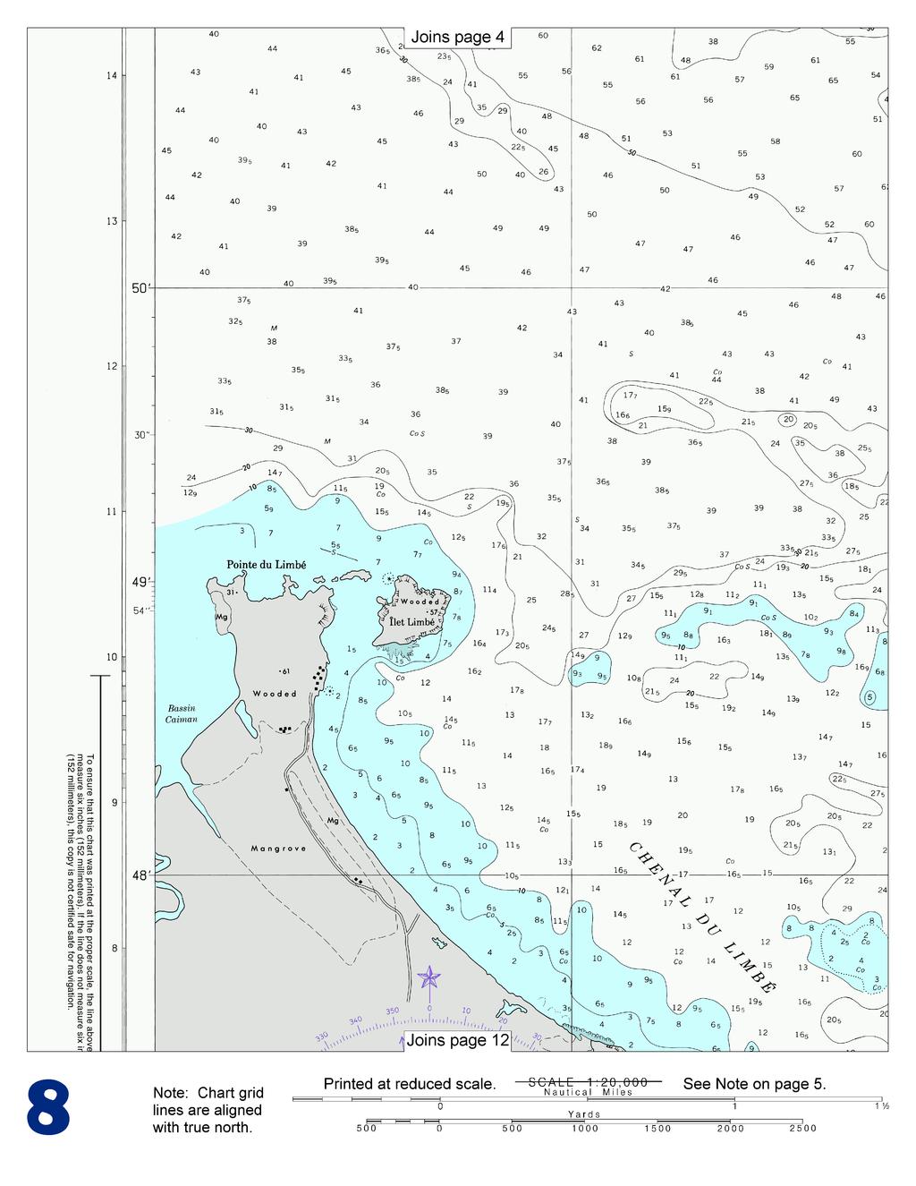
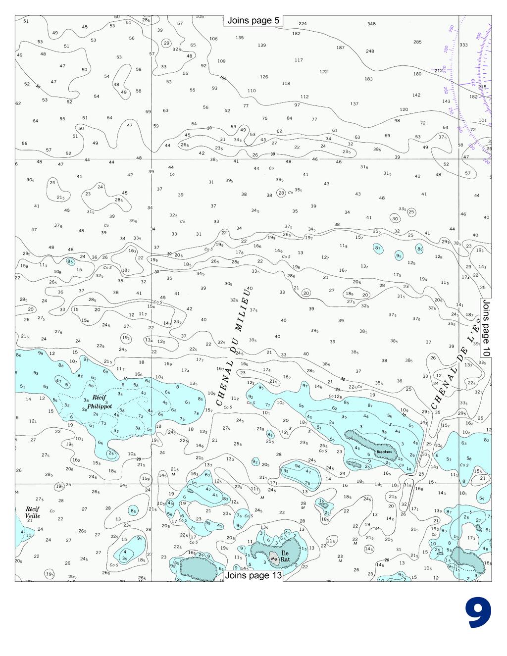
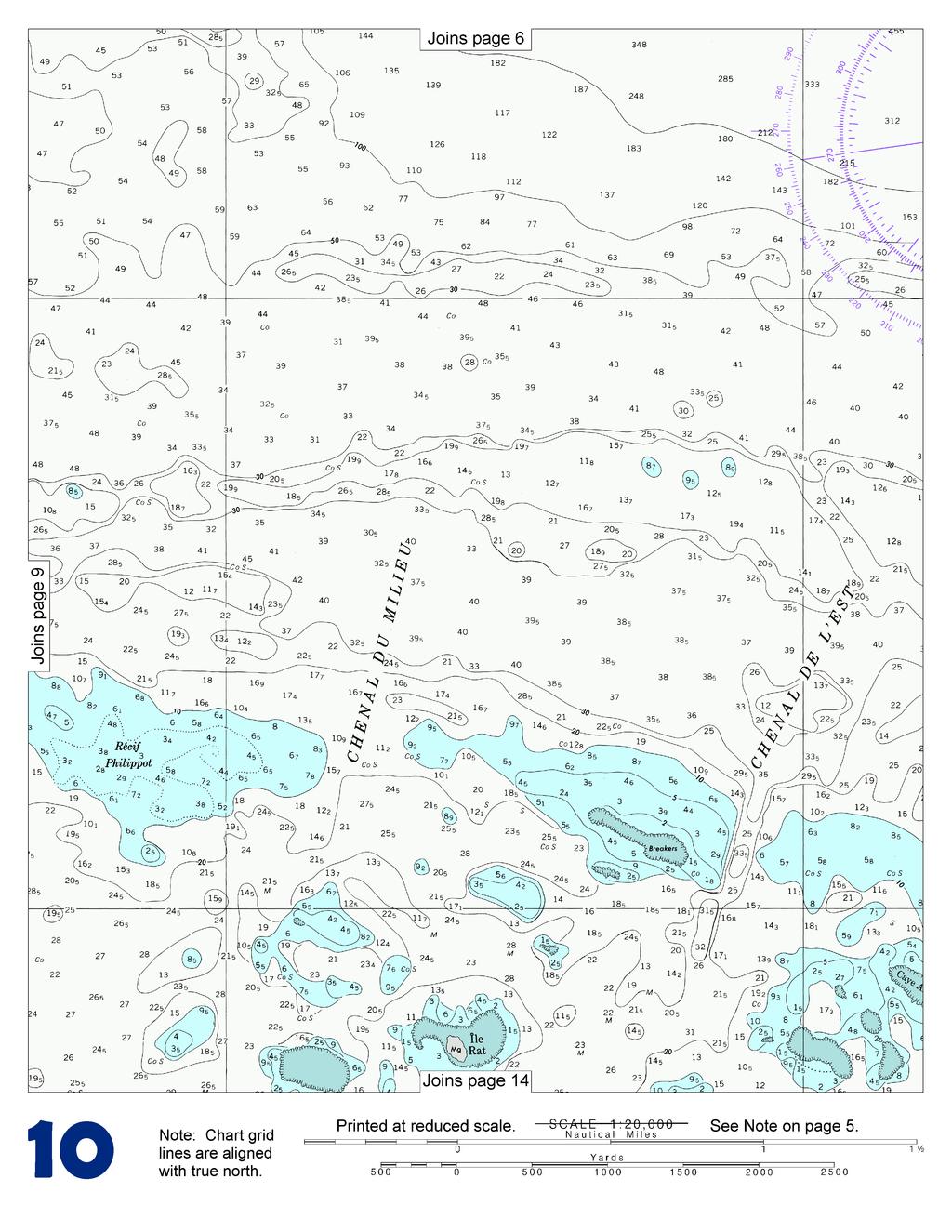
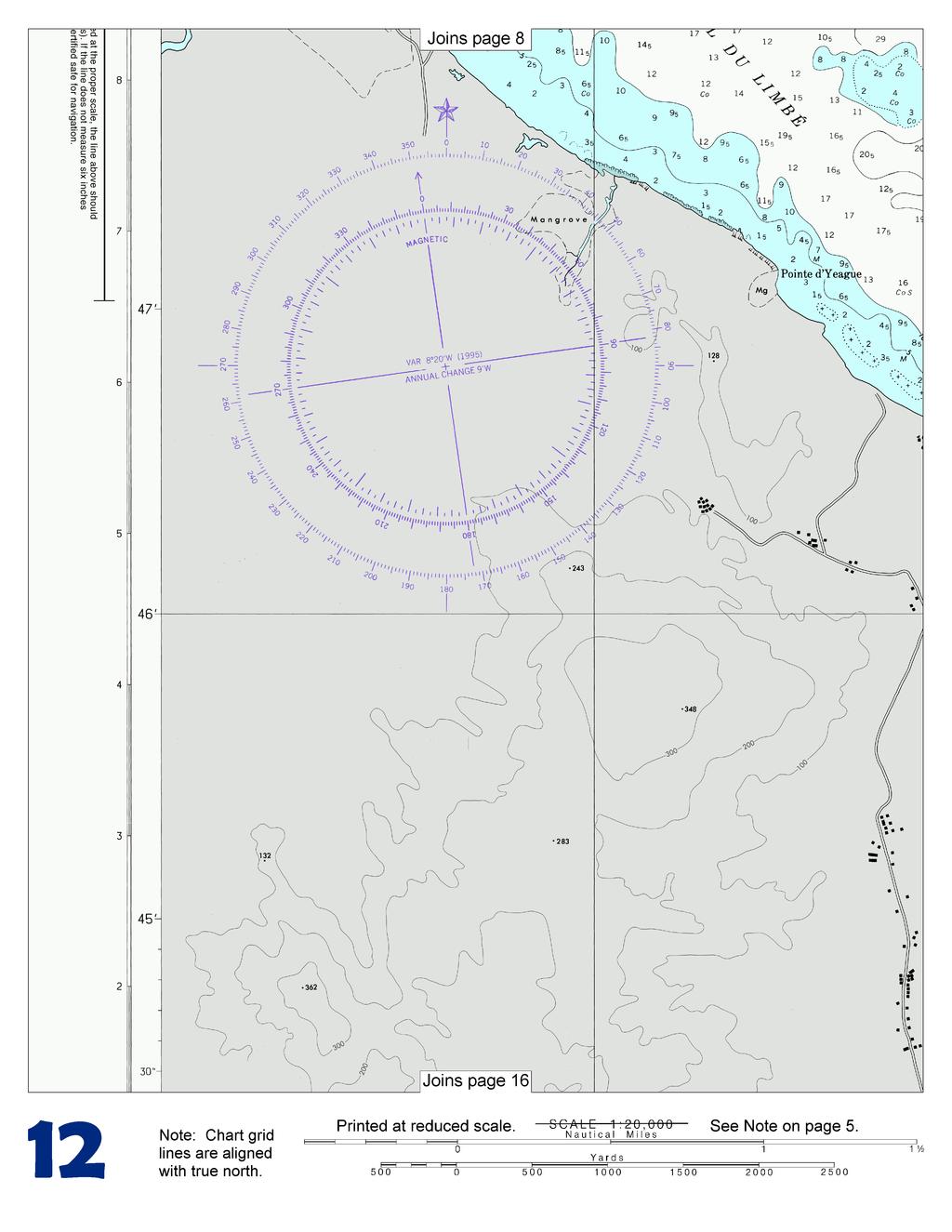
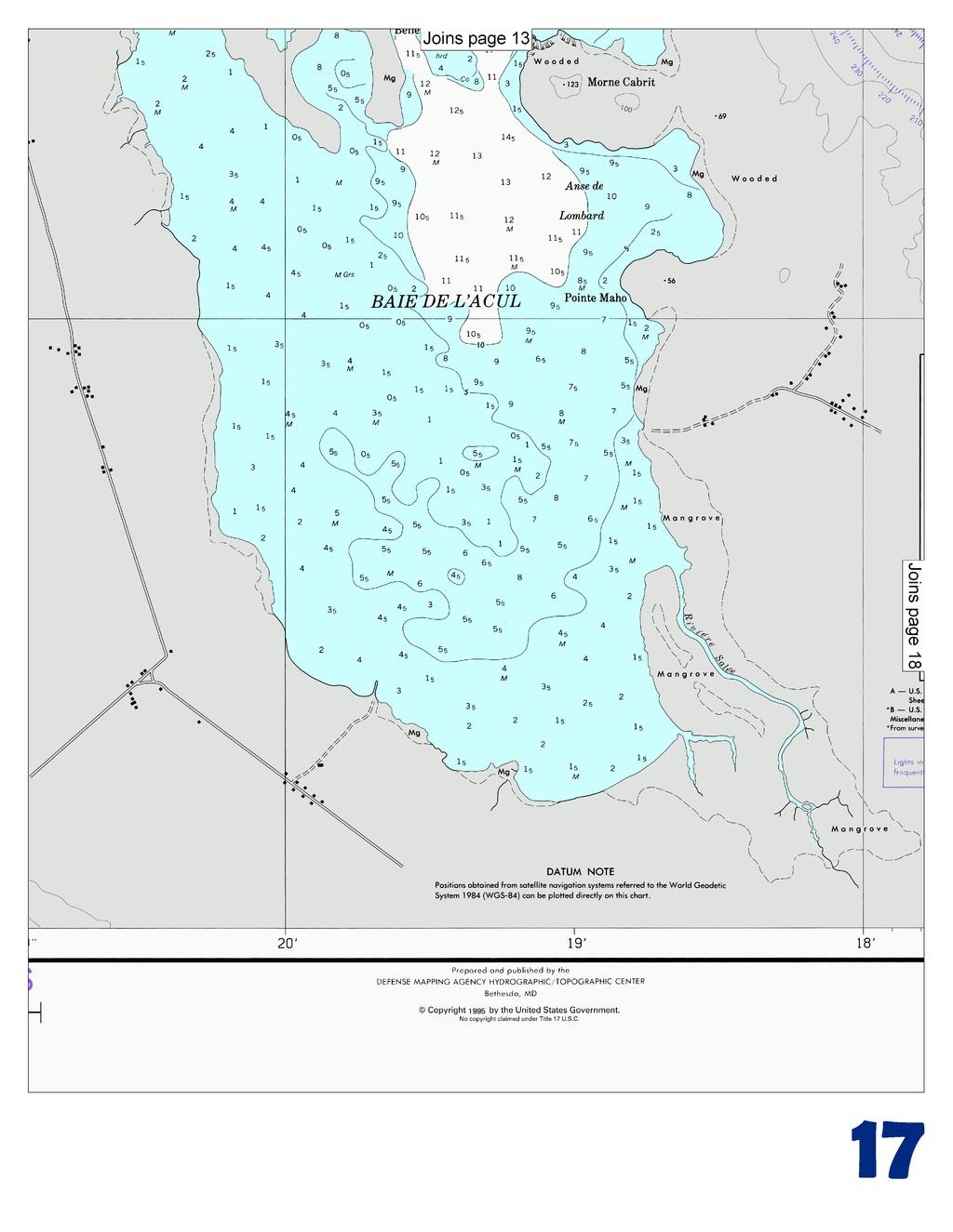
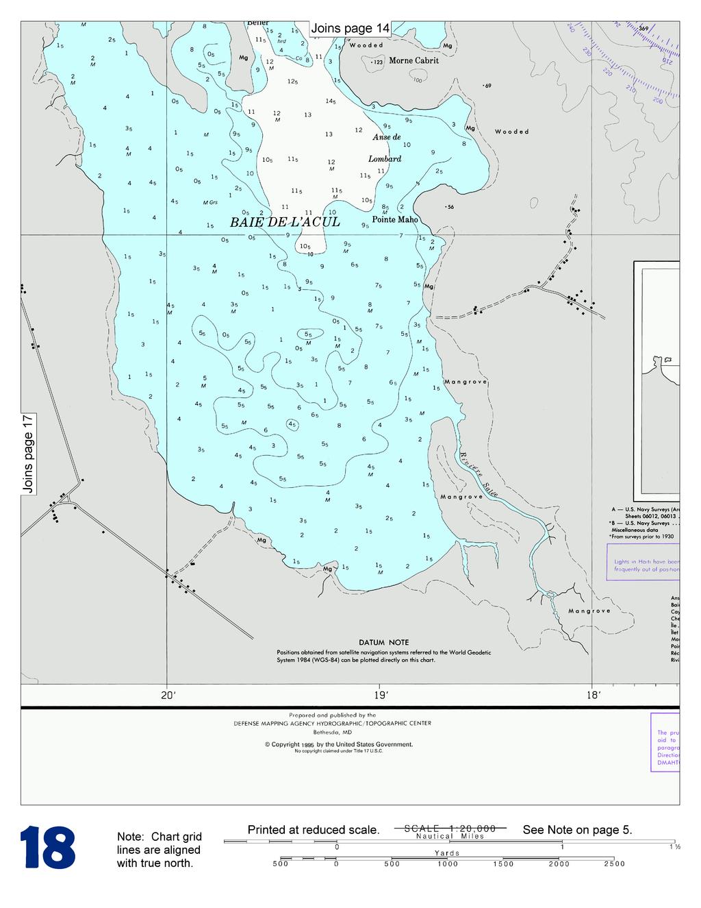
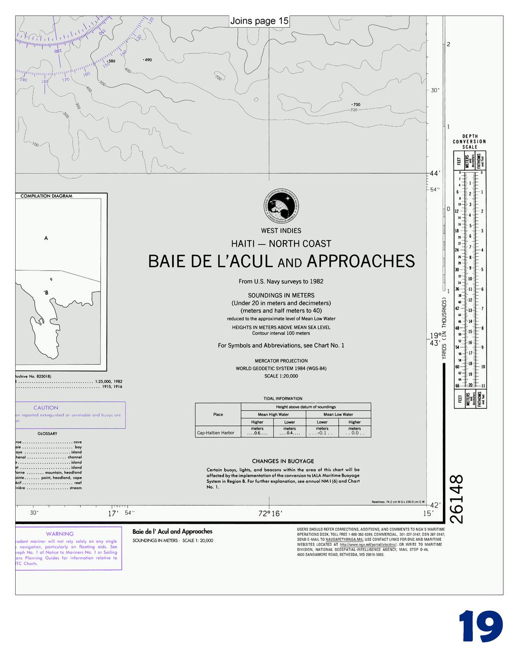
1 BookletChart Baie de L Acul and Approaches (Haiti) NGA Chart A reduced-scale NGA nautical chart for small boaters When possible, use the full-size NGA chart or Electronic Nautical Chart (ENC) for navigation.


2 VHF Marine Radio channels for use on the waterways: Channel 6 Inter-ship safety communications. Channel 9 Communications between boats and ship-to-coast. Channel 13 Navigati purposes at bridges, locks, and harbors. Channel 16 Emergency, distress and safety calls to Coast Guard and others, and to initiate calls to other vessels. Contact the other vessel, agree to another channel, and then switch. Channel 22A Calls between the Coast Guard and the public. Severe weather warnings, hazards to navigation and safety warnings are broadcast here. Channels 68, 69, 71, 72 and 78A Recreational boat channels. Getting and Giving Help Signal other boaters using visual distress signals (flares, orange flag, lights, arm signals); whistles; horns; and on your VHF radio. You are required by law to help boaters in trouble. Respond to distress signals, but do not endanger yourself. Distress Call Procedures Make sure radio is on. Select Channel 16. Press/Hold the transmit button. Clearly say: MAYDAY, MAYDAY, MAYDAY. Also give: Vessel Name and/or Description; Position and/or Location; Nature of Emergency; Number of People on Board. Release transmit button. Wait for 10 seconds If no response Repeat MAYDAY call. HAVE ALL PERSONS PUT ON LIFE JACKETS! Quick References Nautical chart related products and information - Interactive chart catalog - Report a chart discrepancy - Chart and chart related inquiries and comments - Coast Pilot online - Tides and Currents - Marine Forecasts - National Data Buoy Center - NowCoast web portal for coastal conditions - National Weather Service - National Hurricane Center - Pacific Tsunami Warning Center - Contact Us - For the latest news from Coast Survey, This Booklet chart has been designed for duplex printing (printed on front and back of one sheet). If a duplex option is not available on your printer, you may print each sheet and arrange them back-to-back to allow for the proper layout when viewing. NOAA s Office of Coast Survey The Nation s Chartmaker
3 Miscellaneous Tables 47 Mass Rate Depths Area Linear Conversion Factors Known Value Multiply By Unknown Value inches millimeters centimeters centimeters feet feet centimeters meters nautical miles yard meters meters statute miles feet yards nautical miles nautical miles kilometers 1,609.3 meters nautical miles statute miles square feet square meters acres hectare square meters acres square feet acres 4,046.9 square meters 43,560 square feet hectare acres 10,000 square meters x10 5 square feet fathoms meters meters fathoms feet feet meters feet per second statute miles per hour knots centimeters per second grams knots miles per hour centimeters per second knots feet per second meters per second miles per hour meters per second feet per second knots miles per hour feet per second ounces pounds ounces grams pounds kilograms short tons 2,000 pounds long tons metric tons Mass Volume long tons metric tons barrels (petroleum) barrels (liquid, US) gallons (US) Measurements and Equivalencies Unit nautical mile statute mile cable fathom foot inch meter kilometer knot miles per hour (statute) acre pound (avoirdupois) gram short ton long ton metric ton kilogram liter barrel (petroleum) 2,240 pounds 1.12 short tons metric tons 1,000 kilograms long tons short tons 2,204.6 pounds 42 gallons (US) liters 31.5 gallons (US) gallons (British) liters barrels (petroleum) liters liters gallons (US) Equivalency 1,852 meters 6, feet 5,280 feet 1,609.3 meters kilometers 0.1 nautical mile (CN) 720 feet (US) 6 feet meters meter 2.54 centimeters inches feet yards 1,000 meters feet per second meters per second feet per second meters per second 43,560 square feet 4, square meters gram pound (avoirdupois) ounce 2,000 pounds 2,240 pounds 2,204.6 pounds 2.2 pounds quarts 42 gallons (US)
4
5
6
7
8
9
10
11
12
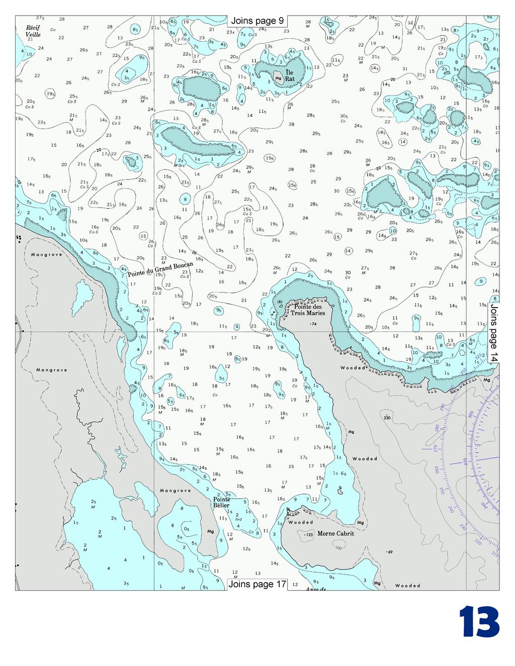
13
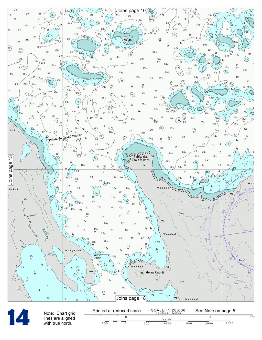
14
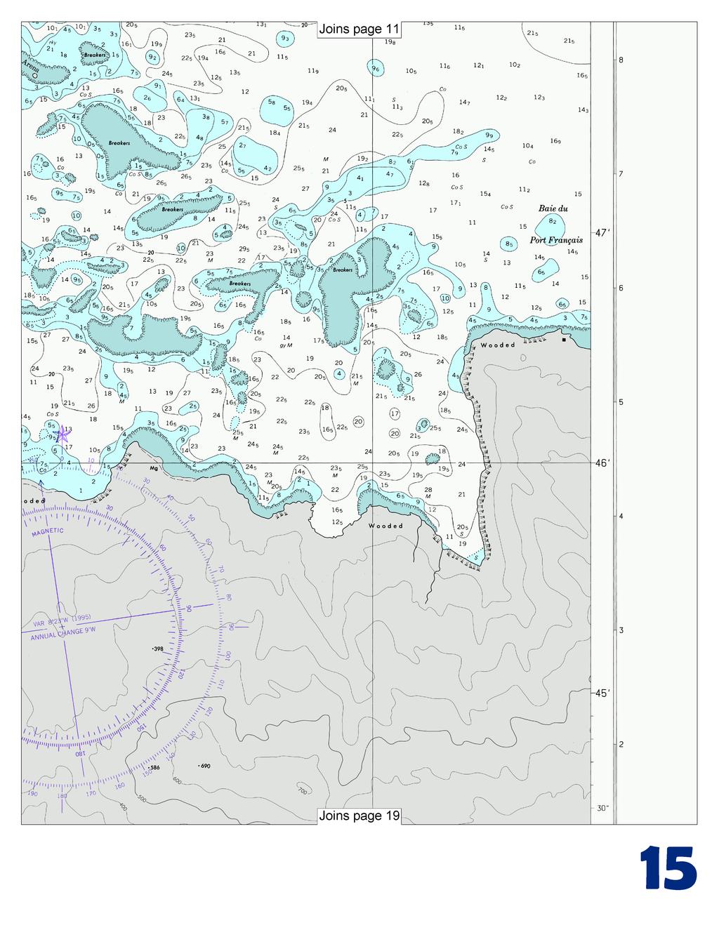
15
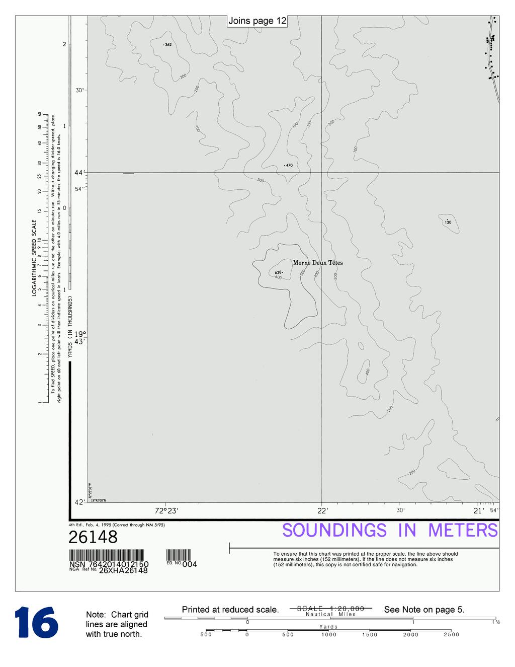
16
17
18
19
20 Chart Baie de L Acul and Approaches (Haiti) Action Charting Label Latitude Longitude Published Document Add Note "ANCHORAGE NOTE 19 42' 12" N 72 23' 00" W 8/02 Vessels may only anchor in charted anchorages as designated by the Dominican Republic Naval Authority. See Sailing Directions. Mariners should contact local authorities for more detailed information." Add Legend "See ANCHORAGE 19 50' 00" N 72 22' 00" W 8/02 NOTE" Add Legend "See ANCHORAGE 19 46' 50" N 72 18' 54" W 8/02 NOTE" Delete ANCHORAGE note 19 42' 12" N 72 23' 00" W 13/02 Delete Legend "See ANCHORAGE 19 50' 00" N 72 22' 00" W 13/02 NOTE" Delete Legend "See ANCHORAGE 19 46' 50" N 72 18' 54" W 13/02 NOTE" Add Legend "See ANCHORAGE NOTE" 19 50' 00" N 72 22' 00" W 8/02 Information obtained through US NtMS 13/2015 (28 March 2015)
BookletChart. Port-au-Prince (Haiti) NGA Chart A reduced-scale NGA nautical chart for small boaters
 NGA Chart A reduced-scale NGA nautical chart for small boaters") BookletChart Port-au-Prince (Haiti) NGA Chart 26186 A reduced-scale NGA nautical chart for small boaters When possible, use the full-size NGA chart or Electronic Nautical Chart (ENC) for navigation. VHF
BookletChart Port-au-Prince (Haiti) NGA Chart 26186 A reduced-scale NGA nautical chart for small boaters When possible, use the full-size NGA chart or Electronic Nautical Chart (ENC) for navigation. VHF
Passages Between Acklins Island, Haiti and Caicos Islands NGA Chart A reduced-scale NGA nautical chart for small boaters
 BookletChart Passages Between Acklins Island, Haiti and Caicos Islands NGA Chart 26260 A reduced-scale NGA nautical chart for small boaters When possible, use the full-size NGA chart or Electronic Nautical
BookletChart. Cap-Haitien NGA Chart A reduced-scale NGA nautical chart for small boaters
 BookletChart Cap-Haitien NGA Chart 26146 A reduced-scale NGA nautical chart for small boaters When possible, use the full-size NGA chart or Electronic Nautical Chart (ENC) for navigation. VHF Marine Radio
BookletChart. Approaches to Cap-Haitien and Bahia de Monti Cristi NGA Chart A reduced-scale NGA nautical chart for small boaters
 BookletChart Approaches to Cap-Haitien and Bahia de Monti Cristi NGA Chart 26142 A reduced-scale NGA nautical chart for small boaters When possible, use the full-size NGA chart or Electronic Nautical Chart
BookletChart. Sacramento River Sacramento to Fourmile Bend NOAA Chart A reduced-scale NOAA nautical chart for small boaters
 BookletChart Sacramento River Sacramento to Fourmile Bend NOAA Chart 18664 A reduced-scale NOAA nautical chart for small boaters When possible, use the full-size NOAA chart for navigation. Included Area
BookletChart. Chesapeake Bay Pocomoke and Tangier Sounds NOAA Chart A reduced-scale NOAA nautical chart for small boaters
 BookletChart Chesapeake Bay Pocomoke and Tangier Sounds NOAA Chart 12228 A reduced-scale NOAA nautical chart for small boaters When possible, use the full-size NOAA chart for navigation. Published by the
BookletChart. Intracoastal Waterway Grassy Key to Bahia Honda Key NOAA Chart A reduced-scale NOAA nautical chart for small boaters
 BookletChart Intracoastal Waterway Grassy Key to Bahia Honda Key NOAA Chart 11453 A reduced-scale NOAA nautical chart for small boaters When possible, use the full-size NOAA chart for navigation. Published
BookletChart. Sacramento River Andrus Island to Sacramento NOAA Chart A reduced-scale NOAA nautical chart for small boaters
 BookletChart Sacramento River Andrus Island to Sacramento NOAA Chart 18662 A reduced-scale NOAA nautical chart for small boaters When possible, use the full-size NOAA chart for navigation. Included Area
BookletChart. St. Joseph and Benton Harbor NOAA Chart A reduced-scale NOAA nautical chart for small boaters
 BookletChart St. Joseph and Benton Harbor NOAA Chart 14930 A reduced-scale NOAA nautical chart for small boaters When possible, use the full-size NOAA chart for navigation. Included Area Published by the
BookletChart. Island of O ahu NOAA Chart A reduced-scale NOAA nautical chart for small boaters
 BookletChart Island of O ahu NOAA Chart 19357 A reduced-scale NOAA nautical chart for small boaters When possible, use the full-size NOAA chart for navigation. Included Area Published by the National Oceanic
Subtract 2-digit numbers mentally with or without regrouping. Use front-end estimation to estimate sums and differences
 3 rd Grade Math in Focus Chapter 1-Numbers to 10,000 Counting Place Value Comparing Ordering Numbers Use base-ten blocks to count, read, write numbers to 10,000 Count on by 1s, 10s, 100s, 1,000s to 10,000
MATH-4 Kaechele_Ott_Measurement and Time Exam not valid for Paper Pencil Test Sessions
 MATH-4 Kaechele_Ott_Measurement and Time Exam not valid for Paper Pencil Test Sessions [Exam ID:YBW Landon needed to measure the mass of a pencil using the metric system. Which unit would be best for him
there is a description of the vessel, you will substitute the prop description of your boat. VHF Booklet
 VHF Booklet Imagine what may happen if a distress situation were to take place and you or a guest on your boat needed to place some form of priority call. In the excitement of the moment, it is easy to
Metric and English Equivalents
 Metric and English Equivalents Linear Measure Metric to Inch Inch to Metric 1 millimeter = 0.03937 inch 1 inch = 25.4 millimeters = 2.54 centimeters 1 centimeter = 0.3937 inch 1 foot = 304.8 millimeters
Measurement / Scale Long-Term Memory Review Grade 6, Standard 3.0 Review 1
 Review 1 1. Convert: 240 mg to g 2. Name a metric unit that measures capacity. 3. Explain how to convert feet to inches. 4. Complete this table:.004 4 1 10,000 5. Joe and Lola are hanging picture frames.
LT Matthew Forney, NOAA Navigation Manager Alaska Region Bering Strait MaritimeSymposium. Office of Coast Survey
 NOAA LT Matthew Forney, NOAA Navigation Manager Alaska Region Bering Strait MaritimeSymposium Who is Coast Survey? First science agency of the U.S. Formed in 1807 Responsible for surveying 3.4 million
Standard Operating Procedures for: VHF Marine Radio
 Serenity Houseboat I. Overview Standard Operating Procedures for: VHF Marine Radio VHF, or Very High Frequency, marine radio is the standard method of communication between vessels. Marine radio equipment
No DECEMBER 2012 UNITED STATES OF AMERICA. Contents
 49 8 DECEMBER 2012 UNITED STATES OF AMERICA Published Weekly by the National Geospatial-Intelligence Agency Prepared Jointly with the National Ocean Service and U.S. Coast Guard Contents Section I Chart
Revision G4. Multiple Choice Identify the choice that best completes the statement or answers the question. 1. What is the perimeter of this figure?
 Revision G4 Multiple Choice Identify the choice that best completes the statement or answers the question. 1. What is the perimeter of this figure? a. 12 cm c. 16 cm b. 24 cm d. 32 cm 2. Becky is using
MARITIME SAFETY INFORMATION
 Introduction 1. Maritime Safety Information (MSI) is defined as navigational and meteorological warnings, meteorological forecasts, and other urgent safety-related messages. This information is of vital
FOR MORE INFORMATION ON GMDSS CONTACT:
 FOR MORE INFORMATION ON GMDSS CONTACT: Commanding Officer USCG Navigation Center, MS 7310, 7323 Telegraph Road, Alexandria, VA 20598-7310 Tel:1-703-313-5900 www.navcen.uscg.gov Commandant (CG-652) Spectrum
SIXTH GRADE MATHEMATICS CHAPTER 10 AREA AND PERIMETER TOPICS COVERED:
 SIXTH GRADE MATHEMATICS CHAPTER 10 AREA AND PERIMETER TOPICS COVERED: Perimeter of Polygons Area of Parallelograms Area of Triangles Area of a Trapezoid Area of Irregular Figures Activity 10-1: Sixth Grade
Converting Within Measurement Systems. ESSENTIAL QUESTION How do you convert units within a measurement system? 6.RP.1.3d
 L E S S O N 7.3 Converting Within Measurement Systems Use ratio reasoning to convert measurment units; manipulate and transform units appropriately when multiplying or dividing quantities. Also 6.RP.1.3
Converting Within Measurement Systems. ESSENTIAL QUESTION How do you convert units within a measurement system? 6.RP.1.3d
 ? L E S S O N 7.3 Converting Within Measurement Systems ESSENTIAL QUESTION How do you convert units within a measurement system? Use ratio reasoning to convert measurement units; manipulate and transform
Overview for Families
 unit: Made to Measure Mathematical strand: Geometry and The following pages will help you to understand the mathematics that your child is currently studying as well as the type of problems (s)he will
Measurement and Data Core Guide Grade 4
 Solve problems involving measurement and conversion of measurements from a larger unit to a smaller unit (Standards 4.MD.1 2) Standard 4.MD.1 Know relative sizes of measurement units within each system
HDD Wire Guided Waterway Crossing ATON Plan. Youghiogheny River (S122)
") HDD Wire Guided Waterway Crossing ATON Plan Youghiogheny River (S122) Mariner East Phase 2 Pipeline Project Prepared for: Sunoco Pipeline, L.P. 535 Friztown Road Sinking Springs, PA 19608 Prepared by:
HDD Wire Guided Waterway Crossing ATON Plan Youghiogheny River (S122) Mariner East Phase 2 Pipeline Project Prepared for: Sunoco Pipeline, L.P. 535 Friztown Road Sinking Springs, PA 19608 Prepared by:
VGLA COE Organizer Mathematics 4
 4.1 The Student will identify the place value for each digit in a whole number expressed through millions a) orally and in writing; b) compare two whole numbers expressed through millions, using symbols
Grade 6 Mathematics Practice Test
 Grade 6 Mathematics Practice Test Nebraska Department of Education 2010 Directions: On the following pages are multiple-choice questions for the Grade 6 Practice Test, a practice opportunity for the Nebraska
Simple Solutions Mathematics Level 3. Level 3. Help Pages & Who Knows Drill
 Level 3 & Who Knows Drill 283 Vocabulary Arithmetic Operations Difference the result or answer to a subtraction problem. Example: The difference of 5 and 1 is 4. Product the result or answer to a multiplication
No MAY 2010 UNITED STATES OF AMERICA. Contents
 18 1 MAY 2010 UNITED STATES OF AMERICA Published Weekly by the National Geospatial-Intelligence Agency Prepared Jointly with the National Ocean Service and U.S. Coast Guard Contents Section I Corrections............................................
WITH MATH INTERMEDIATE/MIDDLE (IM) GRADE 6
 GRADE 6") May 06 VIRGINIA MATHEMATICS STANDARDS OF LEARNING CORRELATED TO MOVING WITH MATH INTERMEDIATE/MIDDLE (IM) GRADE 6 NUMBER AND NUMBER SENSE 6.1 The student will identify representations of a given percent
May 06 VIRGINIA MATHEMATICS STANDARDS OF LEARNING CORRELATED TO MOVING WITH MATH INTERMEDIATE/MIDDLE (IM) GRADE 6 NUMBER AND NUMBER SENSE 6.1 The student will identify representations of a given percent
5 th Grade Powers of 10. Part I. What are powers of 10?
 5 th Grade Powers of 10 Part I. What are powers of 10? 1 1 1 1 1, 10, 100, 1000, 10000, etc. are all powers of 10. The fractions,,,, etc. are 10 100 1000 10000 also considered powers of 10. In decimal
Long-term Memory Review CRT PRACTICE 6 th Grade: MONDAY REVIEW STATE STANDARDS AND 3.6.2
 CRT PRACTICE 6 th Grade: MONDAY REVIEW 1) Convert: 240 mg to g 2) Name a metric unit that measures capacity. 3) Explain how one would convert feet to inches. 4) Complete this table:.004 4 1 10,000 5) Joe
No MARCH 2014 UNITED STATES OF AMERICA. Contents
 10 8 MARCH 2014 UNITED STATES OF AMERICA Published Weekly by the National Geospatial-Intelligence Agency Prepared Jointly with the National Ocean Service and U.S. Coast Guard Contents Section I Chart Corrections............................................
Emergency Marine Communications
 Emergency Marine Communications Presented by: Steve Chamberlin Content:Chuck Hawley Safety at Sea Seminar US Sailing Goals of Emergency Communications To alert rescue services to your situation To get
7-1. Enrichment. Savings Riot. Shopping with Compatible Numbers
 7- Shopping with Compatible Numbers Suppose that you are meeting a friend for lunch and come across the sale advertised at the right. For weeks, you have wanted to buy a set of CDs that is regularly priced
SAFETY EQUIPMENT AND PREPARATION. S/V Odette USA 5619
 SAFETY EQUIPMENT AND PREPARATION S/V Odette USA 5619 Odette5619@gmail.com COMMUNICATION PREPARATION Dedicate dock time for crew to familiarize themselves with all communication equipment: VHF: Walk through
4th Grade Common Core Math Vocabulary
 + = + = + = + = + 4th Grade Common Core Math Vocabulary Created by Alexis Sergi Alexis Sergi http://www.teachersnotebook.com/shop/mathmojo = + = + + = + = + 1 Table of Contents!!!!!!!!!!!! Page Number
Northern York County School District Curriculum
 Northern York County School District Curriculum Course Name Grade Level Mathematics Fourth grade Unit 1 Number and Operations Base Ten Time Frame 4-5 Weeks PA Common Core Standard (Descriptor) (Grades
No OCTOBER 2012 UNITED STATES OF AMERICA. Contents
 41 13 OCTOBER 2012 UNITED STATES OF AMERICA Published Weekly by the National Geospatial-Intelligence Agency Prepared Jointly with the National Ocean Service and U.S. Coast Guard Contents Section I Chart
12 inches 4 feet = 48 inches
 Free Pre-Algebra Lesson 9! page Lesson 9 Converting Between Units How many minutes in a year? How many feet in sixteen and one-quarter miles? The need to convert between units arises so frequently that
Wednesday. Friday. Monday. Thursday. Tuesday. Name: Monday March 14 th Performance Coach pages
 Homework Students will continue reviewing for the FSA. Please check and make sure your children are completing their homework and showing their work. There will be a Quiz on Thursday reviewing Performance
No FEBRUARY 2017 UNITED STATES OF AMERICA. Contents
 6 11 FEBRUARY 2017 UNITED STATES OF AMERICA Published Weekly by the National Geospatial-Intelligence Agency Prepared Jointly with the National Ocean Service and U.S. Coast Guard Contents Section I Chart
For Preview Only GEO5 STUDENT PAGES. GEOMETRY AND MEASUREMENT Student Pages for Packet 5: Measurement. Name Period Date
 Name Period Date GEO5 STUDENT PAGES GEOMETRY AND MEASUREMENT Student Pages for Packet 5: GEO5.1 Conversions Compare measurements within and between measurement systems. Convert measurements within and
No DECEMBER 2008 UNITED STATES OF AMERICA. Contents
 52 27 DECEMBER 2008 UNITED STATES OF AMERICA Published Weekly by the National Geospatial-Intelligence Agency Prepared Jointly with the National Ocean Service and U.S. Coast Guard Contents Section I Chart
4 th Grade Curriculum Map
 4 th Grade Curriculum Map 2017-18 MONTH UNIT/ CONTENT CORE GOALS/SKILLS STANDARDS WRITTEN ASSESSMENTS ROUTINES RESOURCES VOCABULARY September Chapter 1 8 days NUMBERS AND OPERATIONS IN BASE TEN WORKING
No OCTOBER 2016 UNITED STATES OF AMERICA. Contents
 42 15 OCTOBER 2016 UNITED STATES OF AMERICA Published Weekly by the National Geospatial-Intelligence Agency Prepared Jointly with the National Ocean Service and U.S. Coast Guard Contents Section I Chart
No NOVEMBER 2011 UNITED STATES OF AMERICA. Contents
 46 12 NOVEMBER 2011 UNITED STATES OF AMERICA Published Weekly by the National Geospatial-Intelligence Agency Prepared Jointly with the National Ocean Service and U.S. Coast Guard Contents Section I Corrections............................................
ShillerMath Book 4 Test Answers
 ShillerMath Book 4 Test Answers LESSON 4-44 REVIEW TEST #4-1 ANSWERS HOW KIDS LEARN MATH Grading instructions: compare the answers here to the student s answers. For each correct answer, add the appropriate
Digital Selective Calling (DSC) Radios
 Radios") Digital Selective Calling (DSC) Radios The Global Maritime Distress Safety System (GMDSS) DSC radios are an integral part of the Global Maritime Distress Safety System (GMDSS), which is an internationally
Digital Selective Calling (DSC) Radios The Global Maritime Distress Safety System (GMDSS) DSC radios are an integral part of the Global Maritime Distress Safety System (GMDSS), which is an internationally
4-5 Convert Measurement Units. Complete ft = yd SOLUTION: Since 1 yard = 3 feet, multiply by lb = oz SOLUTION:
 Complete. 1. 18 ft = yd Since 1 yard = 3 feet, multiply by. 2. 2 lb = oz Since 16 ounces = 1 pound, multiply by. 3. 6.5 c = fl oz Since 8 fluid ounces = 1 cup, multiply by. 4. 2 mi = ft Since 5,280 feet
Name Date / / Model 1: Dominoes. The game below is called equivalent measures. Critical Thinking Questions:
 Name Date / / Why? In science we take measurements. For those measurements to have any meaning they must contain both a number and a unit, e.g. 12 inches. Numbers alone don t relay enough information.
DOWNLOAD OR READ : THE NAUTICAL CHART PDF EBOOK EPUB MOBI
 DOWNLOAD OR READ : THE NAUTICAL CHART PDF EBOOK EPUB MOBI Page 1 Page 2 the nautical chart the nautical chart pdf the nautical chart NOAA ENCs (ENC): Vector files of chart features and available in S-57
Essentials of Navigation
 Essentials of Navigation Latitudes & Longitudes, GPS, and more For Race Officers and Mark Boat Operators by Ed Bottrell eztrap Developer Glen Haven, Nova Scotia CANADA v13 email: info@bottrell.ca Website:
Measurements. How to Calculate. Grades 5 6. Robert Smith. Author
 Editors Polly Hoffman Gisela Lee Editorial Manager Karen J. Goldfluss, M.S. Ed. Editor-in-Chief Sharon Coan, M.S. Ed. How to Calculate Measurements Cover Artist Jessica Orlando Grades 5 6 Art Coordinator
The Future in Marine Radio Communication GMDSS. Department of Transportation United States Coast Guard
 The Future in Marine Radio Communication GMDSS Department of Transportation United States Coast Guard Do you use a Maritime Radio System? If so, the new Global Maritime Distress and Safety System (GMDSS)
(P.27)
") (P.27) 27 7 210 120 8 * Navigation and Anchoring Prohibited Area has been changed since June, 2017. 9 Port of Osaka The Guidelines of Measures for preventing Typhoon Disaster ( Objective )
(P.27) 27 7 210 120 8 * Navigation and Anchoring Prohibited Area has been changed since June, 2017. 9 Port of Osaka The Guidelines of Measures for preventing Typhoon Disaster ( Objective )
Schooner MADELINE CREW TRAINING MANUAL SECTION C SAFETY
 Schooner MADELINE CREW TRAINING MANUAL SECTION C SAFETY C1 SAFETY RULES & GUIDELINES The safety and health of all crew members are of up most importance to MHA, its Captains and Mates. Fires, accidents,
No MAY 2010 UNITED STATES OF AMERICA. Contents
 19 8 MAY 2010 UNITED STATES OF AMERICA Published Weekly by the National Geospatial-Intelligence Agency Prepared Jointly with the National Ocean Service and U.S. Coast Guard Contents Section I Corrections............................................
THIS CIRCULAR LETTER REQUIRES YOU TO VOTE. IHB File No. S3/8151/CHRIS CIRCULAR LETTER 93/ November 2008
 THIS CIRCULAR LETTER REQUIRES YOU TO VOTE IHB File No. S3/8151/CHRIS CIRCULAR LETTER 93/2008 17 November 2008 REVIEW OF IHO TECHNICAL RESOLUTIONS BY THE COMMITTEE ON HYDROGRAPHIC REQUIREMENTS FOR INFORMATION
Third Grade Mathematics
 Standard 1: Number & Operation 3.M.1.1.1 Read, write, compare, and order whole numbers to 10,000. (287.01.a) and use numbers 38-40% and use numbers Content Limit: When comparing numbers between 1,000 and
Tennessee Comprehensive Assessment Program TCAP. Math Grade 5 Practice Test Subpart 1, Subpart 2, & Subpart 3. Student Name.
 Tennessee Comprehensive Assessment Program TCAP Math Grade 5 Practice Test Subpart 1, Subpart 2, & Subpart 3 Student Name Teacher Name Published under contract with the Tennessee Department of Education
No APRIL 2012 UNITED STATES OF AMERICA. Contents
 15 14 APRIL 2012 UNITED STATES OF AMERICA Published Weekly by the National Geospatial-Intelligence Agency Prepared Jointly with the National Ocean Service and U.S. Coast Guard Contents Section I Chart
Saxon Math K, Math 1, Math 2, and Math 3 Scope and Sequence
 ,,, and Scope and Sequence Numbers and Operations Number Sense and Numeration Counts by 1 s, 5 s, and 10 s Counts by 2 s, 25 s Counts by 100 s Counts by 3 s, 4 s Counts by 6 s, 7 s, 8 s, 9 s, and 12 s
MATH NEWS. 5 th Grade Math. Focus Area Topic A. Grade 5, Module 2, Topic A. Words to know. Things to Remember:
 MATH NEWS Grade 5, Module 2, Topic A 5 th Grade Math Focus Area Topic A Math Parent Letter This document is created to give parents and students a better understanding of the math concepts found in Eureka
G-MG.A: Geometric Measurement and Dimension Explain volume formulas and use them to solve problems
 Name: Date: G-MG.A: Geometric Measurement and Dimension Explain volume formulas and use them to solve problems 1. A shipping container is in the shape of a right rectangular prism with a length of 12 feet,
Measurement and Data. Set 2. Daily Practice Items And Answer Keys
 Measurement and Data Set 2 Daily Practice Items And Answer Keys Daily Practice Measurement DAY 6 1. The perimeter of a square is 36 inches. What is the length of one side of the square? Explain your reasoning.
NOAA Navigation Services Update
 NOAA Navigation Services Update Captain Jim Crocker Chief, Navigation Services Division NOAA s More than Two Centuries of Service First U.S. gov t science agency President Thomas Jefferson created the
HAND RECEIPT COVERING CONTENTS OF COMPONENTS OF END ITEM (COEI), BASIC ISSUE ITEMS (BII), AND ADDITIONAL AUTHORIZATION LIST (AAL) FOR
, BASIC ISSUE ITEMS (BII), AND ADDITIONAL AUTHORIZATION LIST (AAL) FOR") TM 32-5895-263-14&P-HR HAND RECEIPT COVERING CONTENTS OF COMPONENTS OF END ITEM (COEI), BASIC ISSUE ITEMS (BII), AND ADDITIONAL AUTHORIZATION LIST (AAL) FOR MONITORING SET, RADIO AN/TRR-33 NSN 5895-00-168-9564
TM 32-5895-263-14&P-HR HAND RECEIPT COVERING CONTENTS OF COMPONENTS OF END ITEM (COEI), BASIC ISSUE ITEMS (BII), AND ADDITIONAL AUTHORIZATION LIST (AAL) FOR MONITORING SET, RADIO AN/TRR-33 NSN 5895-00-168-9564
No JANUARY 2011 UNITED STATES OF AMERICA. Contents
 3 15 JANUARY 2011 UNITED STATES OF AMERICA Published Weekly by the National Geospatial-Intelligence Agency Prepared Jointly with the National Ocean Service and U.S. Coast Guard Contents Section I Corrections............................................
National Maritime Center
 National Maritime Center Providing Credentials to Mariners (Sample Examination) Page 1 of 6 Choose the best answer to the following Multiple Choice Questions. 1. The following questions are based on Chart
RESOLUTION MSC.229(82) (adopted on 5 December 2006) ADOPTION OF A NEW MANDATORY SHIP REPORTING SYSTEM "IN THE GALAPAGOS PARTICULARLY SENSITIVE SEA
 (adopted on 5 December 2006) ADOPTION OF A NEW MANDATORY SHIP REPORTING SYSTEM IN THE GALAPAGOS PARTICULARLY SENSITIVE SEA") MSC 82/24/Add.2 RESOLUTION MSC.229(82) IN THE GALAPAGOS PARTICULARLY SENSITIVE SEA AREA (PSSA) (GALREP) THE MARITIME SAFETY COMMITTEE, RECALLING Article 28(b) of the Convention on the International Maritime
MSC 82/24/Add.2 RESOLUTION MSC.229(82) IN THE GALAPAGOS PARTICULARLY SENSITIVE SEA AREA (PSSA) (GALREP) THE MARITIME SAFETY COMMITTEE, RECALLING Article 28(b) of the Convention on the International Maritime
4 rows of 6 4 x 6 = rows of 4 6 x 4 = 24
 Arrays 8/8/16 Array a rectangular arrangement of equal rows 4 4 rows of 6 4 x 6 = 24 6 6 6 rows of 4 6 x 4 = 24 4 Dimension the number of rows and columns in an array Multiplication the operation of repeated
4 th Grade Math Notebook
 4 th Grade Math Notebook By: Aligned to the VA SOLs Table of Contents Quarter 1 Table of Contents Quarter 2 Table of Contents Quarter 3 Table of Contents Quarter 4 Hundred Millions Ten Millions Millions
RESOLUTION MSC.278(85) (adopted on 1 December 2008) ADOPTION OF THE NEW MANDATORY SHIP REPORTING SYSTEM "OFF THE COAST OF PORTUGAL - COPREP"
 (adopted on 1 December 2008) ADOPTION OF THE NEW MANDATORY SHIP REPORTING SYSTEM OFF THE COAST OF PORTUGAL - COPREP") MSC 85/26/Add.1 RESOLUTION MSC.278(85) SYSTEM OFF THE COAST OF PORTUGAL COPREP THE MARITIME SAFETY COMMITTEE, RECALLING Article 28 of the Convention on the International Maritime Organization concerning
MSC 85/26/Add.1 RESOLUTION MSC.278(85) SYSTEM OFF THE COAST OF PORTUGAL COPREP THE MARITIME SAFETY COMMITTEE, RECALLING Article 28 of the Convention on the International Maritime Organization concerning
1.2: Measurement. Example 1.2.1: Naming measures on a standard ruler Name the measurements: Section 1.2
 1.2: Measurement Section 1.2 Simply put, measurement is the language of industry. A familiarity with the metric and standard systems of measurement is essential in creating and reading blueprints. The
RADIO AIDS TO MARINE NAVIGATION (Atlantic, St. Lawrence, Great Lakes, Lake Winnipeg and Eastern Arctic) CANADIAN COAST GUARD
 CANADIAN COAST GUARD") RADIO AIDS TO MARINE NAVIGATION (Atlantic, St Lawrence, Great Lakes, Lake Winnipeg and Eastern Arctic) CANADIAN COAST GUARD Marine Communications and Traffic Services Annual Edition 2006 IMPORTANT This
RADIO AIDS TO MARINE NAVIGATION (Atlantic, St Lawrence, Great Lakes, Lake Winnipeg and Eastern Arctic) CANADIAN COAST GUARD Marine Communications and Traffic Services Annual Edition 2006 IMPORTANT This
Ohio s State Tests PRACTICE TEST GRADE 4 MATHEMATICS. Student Name
 Ohio s State Tests PRACTICE TEST GRADE MATHEMATICS Student Name The Ohio Department of Education does not discriminate on the basis of race, color, national origin, sex, religion, age, or disability in
Ohio s State Tests PRACTICE TEST LARGE PRINT GRADE 4 MATHEMATICS. Student Name
 Ohio s State Tests PRACTICE TEST LARGE PRINT GRADE MATHEMATICS Student Name The Ohio Department of Education does not discriminate on the basis of race, color, national origin, sex, religion, age, or disability
Universidad Nacional Experimental Marítima del Caribe Vicerrectorado Académico Cátedra de Idiomas Inglés VI. Ingeniería Marítima
 Universidad Nacional Experimental Marítima del Caribe Vicerrectorado Académico Cátedra de Idiomas Inglés VI. Ingeniería Marítima UNIT II. Navigational equipment found onboard ships. Speaking. 1. Can you
Math 6/7 Unit 10 - GEOMETRY - Study Guide (SOL 6.10)
") Math 6/7 Unit 10 - GEOMETRY - Study Guide (SOL 6.10) Find the perimeter of the following (include the correct units): 1) 2) 5.3 cm 15 ft 15 ft 10.6 cm 18 ft P = P = Solve the following (include the correct
Math 6/7 Unit 10 - GEOMETRY - Study Guide (SOL 6.10) Find the perimeter of the following (include the correct units): 1) 2) 5.3 cm 15 ft 15 ft 10.6 cm 18 ft P = P = Solve the following (include the correct
ROUTEING OF SHIPS, SHIP REPORTING AND RELATED MATTERS. Establishment of a Mandatory Ship Reporting System in the
 INTERNATIONAL MARITIME ORGANIZATION E SUB-COMMITTEE ON SAFETY OF NAVIGATION 48th session Agenda item 3 IMO NAV 48/3/2 11 April 2002 Original: ENGLISH ROUTEING OF SHIPS, SHIP REPORTING AND RELATED MATTERS
Western Region enavigation Sub- Committee Report
 Western Region enavigation Sub- Committee Report Western Region enavigation meeting - Jan 12 18 BC Ferries BC Coast Pilots BCIT Marine Campus Canadian Coast Guard Canadian Hydrographic Services Canadian
Event Organisers are advised to consider having a dedicated channel for safety and rescue communications.
 RowSafe Effective use of the radios relies on keeping transmissions short and to the point, speaking clearly and following basic internationally recognised procedure. The following guidelines are based
3. Use words to write 26,615 and 92,980. Which number is greater?
 Chapter 10 Review Name: 1. Compare the fractions. Write >,
e-navigation Progress and trends: the IHO perspective
 International Hydrographic Organization e-navigation Progress and trends: the IHO perspective Gilles Bessero Director, IHO International Hydrographic Organization Intergovernmental consultative and technical
Why is math important in. healthcare?
 00 000 00 0 000 000 0 Why is math important in 00 000 00 0 000 000 0 healthcare? Health care workers are required to perform simple math calculations when doing various tasks. Mathematical errors may result
CHAPTER 66 QUARTERMASTER (QM) NAVPERS E CH-67
 NAVPERS E CH-67") CHAPTER 66 QUARTERMASTER (QM) NAVPERS 18068-66E CH-67 Updated: July 2016 TABLE OF CONTENTS QUARTERMASTER (QM) SCOPE OF RATING GENERAL INFORMATION NAVIGATION ADMINISTRATOR COMMUNICATIONS ELECTRONIC SYSTEMS
CHAPTER 66 QUARTERMASTER (QM) NAVPERS 18068-66E CH-67 Updated: July 2016 TABLE OF CONTENTS QUARTERMASTER (QM) SCOPE OF RATING GENERAL INFORMATION NAVIGATION ADMINISTRATOR COMMUNICATIONS ELECTRONIC SYSTEMS
PRODUCTS AND SERVICES FOR THE MARITIME COMMUNITY. Ed Martin, Chief Customer Affairs Branch Navigation Services Division Monday, 27 October, 2008
 PRODUCTS AND SERVICES FOR THE MARITIME COMMUNITY Ed Martin, Chief Customer Affairs Branch Navigation Services Division Monday, 27 October, 2008 Coral Reef Conservation International Collaboration Marine
RESOLUTION MSC.230(82) (adopted on 5 December 2006) ADOPTION OF AMENDMENTS TO THE EXISTING MANDATORY SHIP REPORTING SYSTEM "IN THE STOREBÆLT (GREAT
 (adopted on 5 December 2006) ADOPTION OF AMENDMENTS TO THE EXISTING MANDATORY SHIP REPORTING SYSTEM IN THE STOREBÆLT (GREAT") MSC 82/24/Add.2 RESOLUTION MSC.230(82) MANDATORY SHIP REPORTING SYSTEM IN THE STOREBÆLT (GREAT BELT) TRAFFIC AREA THE MARITIME SAFETY COMMITTEE, RECALLING Article 28(b) of the Convention on the International
MSC 82/24/Add.2 RESOLUTION MSC.230(82) MANDATORY SHIP REPORTING SYSTEM IN THE STOREBÆLT (GREAT BELT) TRAFFIC AREA THE MARITIME SAFETY COMMITTEE, RECALLING Article 28(b) of the Convention on the International
2 Scale Drawings Def: a special ratio that gives the. 3 Measurements
 1 Percents Def: a special ratio in which the denominator is 100 Formula pppppppp (iiii) = % wwwwwwwwww (oooo) 111111 What percent of $10 is $4? 2 Scale Drawings Def: a special ratio that gives the relationship
Marine VHF Radio Dan Zeitlin March 11, 2017
 VHF Radio and Beyond Marine VHF Radio Dan Zeitlin March 11, 2017 Agenda Marine VHF radio, its use and operation Why VHF Marine Radio? How VHF Radio Works Radios & Operation Fixed Mount & Handheld Digital
PROVIDING KNOWLEDGE AND KNOWHOW... ANYTIME, ANYWHERE LIGHT LIST. Reference Materials. Digital Edition. Captain Robert L. Figular
 PROVIDING KNOWLEDGE AND KNOWHOW... ANYTIME, ANYWHERE LIGHT LIST Reference Materials Digital Edition Captain Robert L. Figular Page intentionally left blank LIGHT LIST Atlantic Coast of North America MLS
National Maritime Center
 National Maritime Center Providing Credentials to Mariners (Sample Examination) Page 1 of 5 Choose the best answer to the following Multiple Choice Questions. 1. The following questions should be answered
GMDSS for Recreational Boaters
 GMDSS for Recreational Boaters OVERVIEW The Global Maritime Distress and Safety System (GMDSS) is an international system using advanced communications technology. Development of GMDSS was initiated by
No APRIL 2012 UNITED STATES OF AMERICA. Contents
 14 7 APRIL 2012 UNITED STATES OF AMERICA Published Weekly by the National Geospatial-Intelligence Agency Prepared Jointly with the National Ocean Service and U.S. Coast Guard Contents Section I Chart Corrections............................................
VHF 110/210 AIS Series. Owner s Manual
 VHF 110/210 AIS Series Owner s Manual Table of Contents Introduction...1 Radio Overview... 1 Handset Overview... 1 Home Screen... 1 System Status Icons... 1 Basic Operation... 2 Turning On and Off the
Summer Solutions Problem Solving Level 4. Level 4. Problem Solving. Help Pages
 Level Problem Solving 6 General Terms acute angle an angle measuring less than 90 addend a number being added angle formed by two rays that share a common endpoint area the size of a surface; always expressed
Minute Simplify: 12( ) = 3. Circle all of the following equal to : % Cross out the three-dimensional shape.
 = 3. Circle all of the following equal to : % Cross out the three-dimensional shape.") Minute 1 1. Simplify: 1( + 7 + 1) =. 7 = 10 10. Circle all of the following equal to : 0. 0% 5 100. 10 = 5 5. Cross out the three-dimensional shape. 6. Each side of the regular pentagon is 5 centimeters.
Minute 1 1. Simplify: 1( + 7 + 1) =. 7 = 10 10. Circle all of the following equal to : 0. 0% 5 100. 10 = 5 5. Cross out the three-dimensional shape. 6. Each side of the regular pentagon is 5 centimeters.