SAFE TO SEA (S2S) FOR THE SAFETY OF NAVIGTION.
|
|
|
- Felicia McCarthy
- 5 years ago
- Views:
Transcription

1 SAFE TO SEA (S2S) FOR THE SAFETY OF NAVIGTION.


2 GRAFINTA.S.A. Company founded in 1964 and located in Madrid. With 11 people on our payroll from which 8 are engineers specialized in new technologies and advance solutions. Scope of work: System suppliers for the applications of Defense, Survey, Mapping, Oceanography, Hydrography and Environmental Sciences


3 INTRODUCTION. The brands that we represent in Spain. GNSS Receivers Survey Instruments SSS and SBP SW for Hydrography Mobile mapping systems Laser Scanners FOG INS and USBL Lidar systems Multibeam Ecosounder


4 INTRODUCTION. The brands that we represent in Spain. Multibeam and Single Beam Ecosounder Meteorological stations for real time image, IMU and INS systems Oceanographic instruments and buoys Acustics tide Gauge Water column profilers


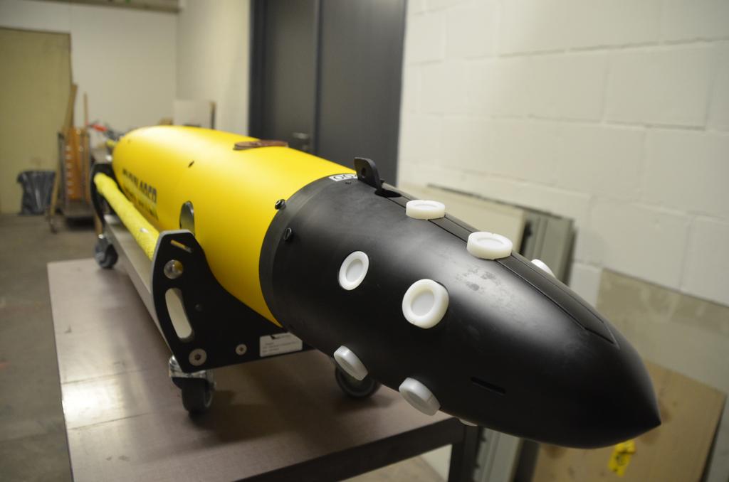
5 INTRODUCTION. Autonomous vehicles. Gliders. AUV with engines. USV Wind propeled. Wide range of ASV with engines. Smalls ASV with engines.
6 INTRODUCTION. PROJECTS OF INTEREST. Some of the contracts that have been awarded by G that might interest to the audience: Sailbouy: Sailing buoy. Is an USV with environmental and hydrocarbon sensors to detecting both refined and raw oils spills in the water surface. SeaExplorer: A Glider platform with Hydrocarbon sensors to detect contamination in the water column. INS Phins for AUV, supplied for a number of projects such as the Girona 500 AUV in collaboration with the company Iqua Robotics (spinoff from Girona University) Litterdrone project participation. Coast s litter automatic location and identification using Remotely Piloted Aircraft Systems (RPAS) and Autonomous marine platforms. DartCom weather and remote sensing stations, for the Peruvian Navy.

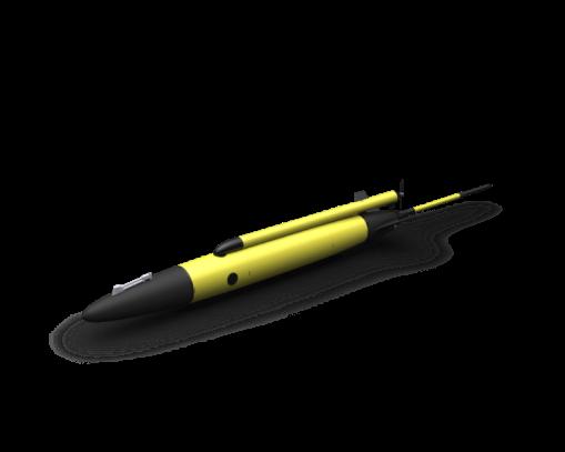
7 INTRODUCTION:SAILBUOY The Sail buoy is a long endurance Unmanned Surface Vehicle (USV) designed to support a wide variety of instrumentation payloads. The Sailbuoy uses the wind as propulsion so the only battery consumption is from the sensors. For long time missions it is possible to add a Solar panel. The configuration, piloting, and data transmission is made through Satellite transmission (Iridium)
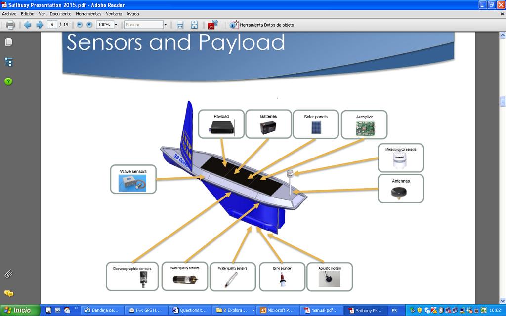
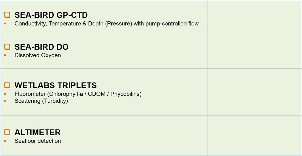
8 INTRODUCTION:SAILBUOY Turner C3 FLUOROMETER AADI OXIGEN NBOSI CT/D WL ECO FL TURBIDITY / CRUDE OIL AND REFINED OIL
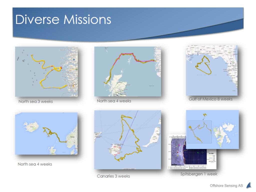
9 INTRODUCTION:SAILBUOY Selected Missions.


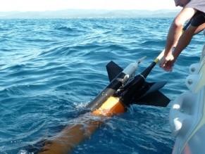
10 INTRODUCTION. SEAEXPLOR Underwater vehicle. Glider. System for long time missions at depths down to 700m. Sensors depending of the mission objectives. Propulsion by buoyance changes. Control: Autopilot, Iridium, UHF. No external moving parts= No breaks! Interchangeable Payload sections. 2 independent CPU. Ballast: 1L


11 INTRODUCTION. SEAEXPLOR Rechargeable Batteries -No vehicle opening -No re-ballasting -Recharging by a single person with low expertise Interchangeable scientific payload section Modularity for quick payload replacement: -Nose sections equipped with different sensors available. -Ballasting weights only in the payload section (No re-ballasting) Easy disconnection of payload sections:


12 INTRODUCTION. SEAEXPLOR AVAILABLE INTEGRATED SENSORS (STANDARDS):


13 INTRODUCTION. SEAEXPLOR AVAILABLE INTEGRATED SENSORS (EXCLUSIVE):

14 INTRODUCTION. SEAEXPLOR AVAILABLE INTEGRATED SENSORS (ON-DEMAND DEVELOPMENTS):


15 INTRODUCTION. GIRONA 500 G is the official provider of the Inertial Navigation for the Girona 500 AUV. Girona 500 AUV -Hovering capability -Depths down to 500m -Open software architecture. Phins Series. -FOG (Fiber optic Gyroscope) -Low power consumption. -Specific subsea operations algorithm. Heading from 0,15dg to 0.01 deg.
16 SAFE TO SEA (S2S) Problem: Gap related to the security in different types of vessels. -Risk derived from the marine activities. -People that are not used to the marine environment Solution: To enhance the security, Safe to Safe is a comfortable solution that can be used to reduced the number of accidents at sea G partnered last year with a Spanish company to provide this solution.

17 SAFE TO SEA (S2S). SAFE TO SEA is an alarm and location aid system 100% reliable and manufactured in Spain, focusing in the safety of navigation in front of MOB (man over board) situations.
 -AIS Automatic")

 -Strobe light. -Battery. *DSC (Digital Selective Calling).")
18 SAFE TO SEA. Main components: -GPS system -Sentinel Station (on board) -AIS Automatic Identification system class B. -Communication system VHF / DSC Class D. -Lifejacket. -MOB detection system. -GPS system. -Personal Unit (crew) -PLB and/or AIS -Automatic inflation system. (Two bottles of CO2) -Strobe light. -Battery. *DSC (Digital Selective Calling). Automatic call system *DSC Class D complain the Global Maritime Distress Safety System (GMDSS) Legislation *PLB. Personal Location Beacon


19 SAFE TO SEA. HOW IT WORKS Automatic and 100% reliable system. Sentinel Station with GPS-AIS navigation system. Radio communication: Safe to Sea use a powerful VHF/DSC radio for sending the alarm messages. Sentinel Station. On board. Usually at the bridge. MOB detected automatically. Alarm on board and alarm transmission to the boats in the area and to maritime rescue. Guided rescue with the position of the man in the water. The life jacket automatically activates the inflation and send the current position through the PLB. Personal units. For the crew.

20 ESTACION S2S SENTINEL. Detail of the Sentinel Station. This unit is in continuous supervision of all the personal units on the vessel. Telemetry ranges: 4 NM with AIS 30 to 50 NM for DSC Alarms. *SAFE TO SEA complies with the ISO / IEC regulations.


21 SAFE TO SAFE. There are several dress options: Bracelet Jacket Full dress Belt


22 SAFE TO SAFE USERS. The convenience of using the SAFE TO SEA system is evident in all the cases where is obvious that there is a potential risk of a crew member falling into de water during the daily works. -Fishing vessels -Commercial vessels -Recreational vessels -Scientific vessel -Military Vessels -Oil, Scientific and other platforms.
23 Thank for your attention. Any question? For further information please contact with G.S.A
EIS - Electronics Instrumentation Systems for Marine Applications
 Coordinating unit: Teaching unit: Academic year: Degree: ECTS credits: 2015 230 - ETSETB - Barcelona School of Telecommunications Engineering 710 - EEL - Department of Electronic Engineering MASTER'S DEGREE
The Oil & Gas Industry Requirements for Marine Robots of the 21st century
 The Oil & Gas Industry Requirements for Marine Robots of the 21st century www.eninorge.no Laura Gallimberti 20.06.2014 1 Outline Introduction: fast technology growth Overview underwater vehicles development
Robots at Work The growing role of robotic systems in the Oceans and Subsea Engineering. David Brookes Senior Advisor, Upstream Engineering, BP
 Robots at Work The growing role of robotic systems in the Oceans and Subsea Engineering David Brookes Senior Advisor, Upstream Engineering, BP Synopsis ROV s History Current Capabilities and Examples AUV
An Introduction to INDUSTRY PARTNERS 25/05/2017. Military Army & Air Force. Government Defense & Rescue. Aviation Maritime Military. Other.
 An Introduction to 1 INDUSTRY PARTNERS Aviation Maritime Military Coast Guard & Navy Military Army & Air Force Government Defense & Rescue Other Commercial Commercial/Workboat Navy Air Force SAR Agencies
OPT Commercialization Update
 OPT Commercialization Update Forward Looking Statements In addition to historical information, this presentation contains forward-looking statements that are within the safe harbor provisions of the Private
UNDERWATER REMOTE MONITORING SOLUTIONS ABOVE THE SPACE AND THE TIME SERIES LIMITS
 UNDERWATER REMOTE MONITORING SOLUTIONS ABOVE THE SPACE AND THE TIME SERIES LIMITS Fundaçâo BIO RIO 1 & 2 February 2017 Vicente Carrasco Subsea Responsible South America Kongsberg Maritime do Brasil AGENDA
Autonomous Underwater Vehicles
 Autonomous Underwater Vehicles A View of the Autonomous Underwater Vehicle Market For a number of years now the Autonomous Underwater Vehicle (AUV) has been the undisputed tool of choice for certain niche
global acoustic positioning system GAPS usbl acoustic with integrated INS positioning system Ixsea Oceano GAPS page 1
 global acoustic positioning system usbl acoustic positioning system with integrated INS positioning system page 1 THE MERGER OF INERTIAL AND UNDERWATER ACOUSTIC TECHNOLOGIES is a unique Global Acoustic
The Future in Marine Radio Communication GMDSS. Department of Transportation United States Coast Guard
 The Future in Marine Radio Communication GMDSS Department of Transportation United States Coast Guard Do you use a Maritime Radio System? If so, the new Global Maritime Distress and Safety System (GMDSS)
Solutions for a blue planet
 Solutions for a blue planet Optimising the businesses of offshore and shallow water professionals with sustainability as our beacon The world is seeing a steady increase in operations at sea in the energy,
Survey Sensors. 18/04/2018 Danny Wake Group Surveyor i-tech Services
 Survey Sensors 18/04/2018 Danny Wake Group Surveyor i-tech Services What do we need sensors for? For pure hydrographic surveying: Depth measurements Hazard identification Seabed composition Tides & currents
Automation at Depth: Ocean Infinity and seabed mapping using multiple AUVs
 Automation at Depth: Ocean Infinity and seabed mapping using multiple AUVs Ocean Infinity s seabed mapping campaign commenced in the summer of 2017. The Ocean Infinity team is made up of individuals from
CODEVINTEC. Miniature and accurate IMU, AHRS, INS/GNSS Attitude and Heading Reference Systems
 45 27 39.384 N 9 07 30.145 E Miniature and accurate IMU, AHRS, INS/GNSS Attitude and Heading Reference Systems Aerospace Land/Automotive Marine Subsea Miniature inertial sensors 0.1 Ellipse Series New
PROTECTING GPS/GNSS-RELIANT MILITARY SYSTEMS
 PROTECTING GPS/GNSS-RELIANT MILITARY SYSTEMS John Fischer VP Advanced R&D Jon Sinden Product Manager, Rugged PNT 6/21/2018 ABOUT OROLIA A world leader in assured positioning, navigation and timing (PNT)
Subsea Monitoring & Mapping
 Subsea Monitoring & Mapping Arnold Hechanova & Dave Fraser ITAC Meeting 2016 Woods Hole Oceanographic Institute, MA Overview Program Objective: Develop sensors to detect loss of containment subsea and
Towards good experimental methodology for Unmanned Marine Vehicles: issues and experiences
 Towards good experimental methodology for Unmanned Marine Vehicles: issues and experiences M. Caccia Consiglio Nazionale delle Ricerche Istituto di Studi sui Sistemi Intelligenti per l Automazione Via
Kordil Surveying & Engineering Services
 Kordil Surveying & Engineering Services About Kordil Kordil Surveying & Engineering Ltd. Co. in short Kordil is an all in one surveying company providing service from Turkey. Hydrography, Oceanography
BSEE Oil Spill Preparedness Division Response Research Branch
 BSEE Oil Spill Preparedness Division Response Research Branch Jay Cho, Ph.D Remote Sensing Research Program To promote safety, protect the environment and conserve resources offshore through vigorous regulatory
Inertial Systems. Ekinox Series TACTICAL GRADE MEMS. Motion Sensing & Navigation IMU AHRS MRU INS VG
 Ekinox Series TACTICAL GRADE MEMS Inertial Systems IMU AHRS MRU INS VG ITAR Free 0.05 RMS Motion Sensing & Navigation AEROSPACE GROUND MARINE EKINOX SERIES R&D specialists usually compromise between high
PHINS, An All-In-One Sensor for DP Applications
 DYNAMIC POSITIONING CONFERENCE September 28-30, 2004 Sensors PHINS, An All-In-One Sensor for DP Applications Yves PATUREL IXSea (Marly le Roi, France) ABSTRACT DP positioning sensors are mainly GPS receivers
CMRE La Spezia, Italy
 Innovative Interoperable M&S within Extended Maritime Domain for Critical Infrastructure Protection and C-IED CMRE La Spezia, Italy Agostino G. Bruzzone 1,2, Alberto Tremori 1 1 NATO STO CMRE& 2 Genoa
Responsive AUV Localization and Mapping Project. Ron Lewis, Project Manager June 14 th, 2012
 Responsive AUV Localization and Mapping Project Ron Lewis, Project Manager June 14 th, 2012 Project Overview Project duration: Approximately 5 Years June 1, 2010 to March 31, 2015 Primary objectives: Develop
TECHNOLOGY DEVELOPMENT AREAS IN AAWA
 TECHNOLOGY DEVELOPMENT AREAS IN AAWA Technologies for realizing remote and autonomous ships exist. The task is to find the optimum way to combine them reliably and cost effecticely. Ship state definition
HIGH-ACCURACY GYROCOMPASS
 HIGH-ACCURACY GYROCOMPASS and INERTIAL NAVIGATION PRODUCTS NAVAL NAVIGATION LAND NAVIGATION & POINTING AIR NAVIGATION COMMERCIAL & INDUSTRIAL GEM elettronica is a leading European supplier in the design,
EGYPTIAN HYDROGRAPHIC DEPARTMENT THE EGYPTIAN HYDROGRAPHIC FRAMEWORK
 gvt THE EGYPTIAN HYDROGRAPHIC FRAMEWORK The roles of a national Hydrographic Service can be summarized in collecting georeferenced data through systematic surveys at sea and along the coast related to:
INESCTEC Marine Robotics Experience
 From Knowledge Generation To Science-based Innovation INESCTEC Marine Robotics Experience Aníbal Matos Robotics@ INESC TEC Universidade do Porto SEAS-ERA Workshop, Lisboa Sep 17-18, 2013 Research and Technological
Radio Log Book. for Canadian Flag Vessels. 1 Master s Signature. Transports Canada. Transport Canada TP 13926E MARINE SAFETY
 Transport Canada MARINE SAFETY Transports Canada TP 13926E Radio Log Book for Canadian Flag Vessels Also for use on GMDSS exempted vessels Date Commenced Date Completed 1 Instructional Guide for Keeping
Satellite services for maritime security
 Satellite services for ITS-T Sophia Antipolis 6 June 2007 Jean-Pierre Cauzac, CLS - Collecte Localisation Satellites 35 Are the seas becoming more dangerous? IMB report 2006 shows improvement: 239 piracy
Teledyne Marine Oil and Gas.
 Oil and Gas www.teledynemarine.com/energy Applications in Oil and Gas Teledyne Marine encompasses over 20 brands that offer innovative, highly reliable technology spanning the life cycle of an oil field,
ROBOSUB. Isaac Peral y Caballero. Future Vehicles. Entrepreneurs
 ROBOSUB Isaac Peral y Caballero FuVe and FUVE association borns from the desire of innovation and entrepreneurship. Formed by 20 students from different universities and specialties we will work to develop
Vision and Strategy to Enhance the Safety Management of Small and Medium Ships in the Era of the Fourth Industrial Revolution
 Vision and Strategy to Enhance the Safety Management of Small and Medium Ships in the Era of the Fourth Industrial Revolution International Safety@Sea Conference 2018 Singapore 21 June 2018 Y. S. Lee President
Tide & Meteorological Data over AIS
 Tide & Meteorological Data over AIS E.F.Read (Ohmex Ltd) & W.S.Heaps (ABP Ltd) THSUK Hydro8 1 Background to AIS Most significant development since RADAR Positions and Timing from GPS network 12.5 Watt
ACR Electronics, Inc Ravenswood Road Fort Lauderdale, FL New Product Briefing SARLink 406 MHz / Iridium Beacon
 ACR Electronics, Inc. 5757 Ravenswood Road Fort Lauderdale, FL 33312 www.acrartex.com New Product Briefing SARLink 406 MHz / Iridium Beacon Two Powerful Brands One Great Company Our Brands Marine, Aviation,
Author s Name Name of the Paper Session. DYNAMIC POSITIONING CONFERENCE October 10-11, 2017 SENSORS SESSION. Sensing Autonomy.
 Author s Name Name of the Paper Session DYNAMIC POSITIONING CONFERENCE October 10-11, 2017 SENSORS SESSION Sensing Autonomy By Arne Rinnan Kongsberg Seatex AS Abstract A certain level of autonomy is already
Teledyne Oil & Gas Innovation and Subsea Reliability
 A Member of Innovation and Subsea Reliability www.teledyneoilandgas.com Technologies A Member of Seismic Instruments Imaging Vehicles Photo Courtesy BMT has been proudly serving the oil and gas industry
ROV TRAINING & SUBSEA SOLUTIONS.
 ROV TRAINING & SUBSEA SOLUTIONS www.qstar.es www.rovs.eu The Company The company THE COMPANY Founded in 2007, QSTAR - ROV TRAINING & SUBSEA SOLUTIONS, located in the Canary Islands & Barcelona (Spain)
Acoustic INS aiding NASNet & PHINS
 NAUTRONIX MARINE TECHNOLOGY SOLUTIONS Acoustic INS aiding NASNet & PHINS Sam Hanton Aberdeen Houston Rio Positioning Options Satellites GPS, GLONASS, COMPASS Acoustics LBL, SBL, USBL Relative sensors Laser
LBL POSITIONING AND COMMUNICATION SYSTEMS PRODUCT INFORMATION GUIDE
 LBL POSITIONING AND COMMUNICATION SYSTEMS PRODUCT INFORMATION GUIDE EvoLogics S2C LBL Underwater Positioning and Communication Systems EvoLogics LBL systems bring the benefi ts of long baseline (LBL) acoustic
L AGENCE NATIONALE DES FREQUENCES (ANFR) From Titanic to satellite from Morse to digital Entry in a new era for the maritime community
 From Titanic to satellite from Morse to digital Entry in a new era for the maritime community") L AGENCE NATIONALE DES FREQUENCES (ANFR) From Titanic to satellite from Morse to digital Entry in a new era for the maritime community ITU regional seminar 6-8 June 2018 St-Petersburg, Russian Federation
L AGENCE NATIONALE DES FREQUENCES (ANFR) From Titanic to satellite from Morse to digital Entry in a new era for the maritime community ITU regional seminar 6-8 June 2018 St-Petersburg, Russian Federation
Inertial Systems. Ekinox 2 Series TACTICAL GRADE MEMS. Motion Sensing & Navigation IMU AHRS MRU INS VG
 Ekinox 2 Series TACTICAL GRADE MEMS Inertial Systems IMU AHRS MRU INS VG ITAR Free 0.02 RMS Motion Sensing & Navigation AEROSPACE GROUND MARINE EKINOX 2 SERIES R&D specialists usually compromise between
BookletChart. Sacramento River Sacramento to Fourmile Bend NOAA Chart A reduced-scale NOAA nautical chart for small boaters
 BookletChart Sacramento River Sacramento to Fourmile Bend NOAA Chart 18664 A reduced-scale NOAA nautical chart for small boaters When possible, use the full-size NOAA chart for navigation. Included Area
1
 12/20/2016 www.made-simplefor-cruisers.com 1 Emergency Position Indicating Radio Beacons (EPIRB) Only 406.0-406.1 EPIRBs with a built in GPS will be authorized for sale in the US. EPIRBs without position
GNSS in Maritime and Education in Egypt
 GNSS in Maritime and Education in Egypt GNSS IN MARITIME PORTS SHIPS PORTS WATERWAYS GNSS maritime applications will help to improve: navigation. Ship operations. Traffic management. Seaport operations.
Inertial Systems. Ekinox 2 Series TACTICAL GRADE MEMS. Motion Sensing & Navigation IMU AHRS MRU INS VG
 Ekinox 2 Series TACTICAL GRADE MEMS Inertial Systems IMU AHRS MRU INS VG ITAR Free 0.02 RMS Motion Sensing & Navigation AEROSPACE GROUND MARINE EKINOX 2 SERIES R&D specialists usually compromise between
Recent Developments in NOAA s Real- Time Coastal Observing Systems for Safe and Efficient Maritime Transportation
 Recent Developments in NOAA s Real- Time Coastal Observing Systems for Safe and Efficient Maritime Transportation Rich Edwing, Director NOAA Center for Operational Oceanographic Products and Services CMTS
Experiences with Hydrographic Data Budgets Using a Low-logistics AUV Platform. Thomas Hiller Teledyne Marine Systems
 Experiences with Hydrographic Data Budgets Using a Low-logistics AUV Platform Thomas Hiller Teledyne Marine Systems 1 Teledyne Marine Systems Strategic Business Units 2 What is the Gavia? The Gavia is
USBL positioning and communication SyStEmS. product information GUidE
 USBL positioning and communication SyStEmS product information GUidE evologics s2c R usbl - series underwater positioning and communication systems EvoLogics S2CR USBL is a series of combined positioning
Pipeline Inspection and Environmental Monitoring Using AUVs
 Pipeline Inspection and Environmental Monitoring Using AUVs Bjørn Jalving, Bjørn Gjelstad, Kongsberg Maritime AUV Workshop, IRIS Biomiljø, 7 8 September 2011 WORLD CLASS through people, technology and
Inertial Navigation System
 Apogee Marine Series ULTIMATE ACCURACY MEMS Inertial Navigation System INS MRU AHRS ITAR Free 0.005 RMS Navigation, Motion & Heave Sensing APOGEE SERIES makes high accuracy affordable for all surveying
Integrity Monitoring using AUVs
 Integrity Monitoring using AUVs Andrew McMurtrie Business Development Manager NCS Survey Limited Subsea Europe, 27-28 October, in Paris Content Introduction to NCS Survey Low logistics, man-portable AUVs
Stiletto. Maritime Demonstration Program C-UUV Capability Demonstration
 Maritime Demonstration Program C-UUV Capability Demonstration Persistent Aquatic Living Sensors (PALS) Proposers Day Presentation Biological Technologies Office (BTO) Defense Advanced Research Projects
Global Maritime Distress and Safety System (GMDSS)
") Global Maritime Distress and Safety System (GMDSS) Global Maritime Distress and Safety System (GMDSS) BACKGROUNG, APPLICATION, DEFINITION GMDSS (Background) SOLAS 74 Ships 1600 TRG Radio Installation Ships
Global Maritime Distress and Safety System (GMDSS) Global Maritime Distress and Safety System (GMDSS) BACKGROUNG, APPLICATION, DEFINITION GMDSS (Background) SOLAS 74 Ships 1600 TRG Radio Installation Ships
Unmanned Aerial Vehicles: A New Approach for Coastal Habitat Assessment
 Unmanned Aerial Vehicles: A New Approach for Coastal Habitat Assessment David Ryan Principal Marine Scientist WorleyParsons Western Operations 2 OUTLINE Importance of benthic habitat assessment. Common
Weatherdock explains: How does real DSC work in an emergency transmitter?
 explains: How does real DSC work in an emergency transmitter? 1 DSC Basics 2 AIS S.A.R.T. & DSC easyrescue-pro 3 DSC closed loop 4 DSC open loop 1 DSC Basics DSC is short cut for Digital Selective Call
Abstract. Composition of unmanned autonomous Surface Vehicle system. Unmanned Autonomous Navigation System : UANS. Team CLEVIC University of Ulsan
 Unmanned Autonomous Navigation System : UANS Team CLEVIC University of Ulsan Choi Kwangil, Chon wonje, Kim Dongju, Shin Hyunkyoung Abstract This journal describes design of the Unmanned Autonomous Navigation
The Nordic Institute of Navigation (NNF)
") The Nordic Institute of Navigation (NNF) www.nornav.org non-profit, independent and a non-political organization for professionals working within the field of navigation. The focus of NNF is on all aspects
The Nordic Institute of Navigation (NNF) www.nornav.org non-profit, independent and a non-political organization for professionals working within the field of navigation. The focus of NNF is on all aspects
GMDSS for Recreational Boaters
 GMDSS for Recreational Boaters OVERVIEW The Global Maritime Distress and Safety System (GMDSS) is an international system using advanced communications technology. Development of GMDSS was initiated by
Applications. > > Oil & Gas. > > RoVs and auvs. > > Oceanography. > > Monitoring stations. > > Seismic. > > Networks and relay chains
 Underwater acoustic Modems EvoLogics S2CR - series underwater acoustic modems provide full-duplex digital communication delivering an excellent performance, resistant to the challenges of the dynamic subsea
HALS-H1 Ground Surveillance & Targeting Helicopter
 ARATOS-SWISS Homeland Security AG & SMA PROGRESS, LLC HALS-H1 Ground Surveillance & Targeting Helicopter Defense, Emergency, Homeland Security (Border Patrol, Pipeline Monitoring)... Automatic detection
RULES FOR THE CONSTRUCTION AND CLASSIFICATION OF MOBILE OFFSHORE DRILLING UNITS TITLE MOBILE OFFSHORE DRILLING UNITS NAUTIC AND ELECTRONICS CHAPTERS
 PARTE II RULES FOR THE CONSTRUCTION AND CLASSIFICATION OF MOBILE OFFSHORE DRILLING UNITS TITLE MOBILE OFFSHORE DRILLING UNITS SECTION 8 NAUTIC AND ELECTRONICS CHAPTERS A B C D SCOPE TECHNICAL DOCUMENTATION
FREQUENCIES FOR DISTRESS AND SAFETY, SEARCH AND RESCUE AND EMERGENCIES
 FREQUENCIES FOR DISTRESS AND SAFETY, SEARCH AND RESCUE AND EMERGENCIES Given the global nature of travel with the potential risk of accidents the international community has agreed that the use of certain
PRODUCTS AND SERVICES FOR THE MARITIME COMMUNITY. Ed Martin, Chief Customer Affairs Branch Navigation Services Division Monday, 27 October, 2008
 PRODUCTS AND SERVICES FOR THE MARITIME COMMUNITY Ed Martin, Chief Customer Affairs Branch Navigation Services Division Monday, 27 October, 2008 Coral Reef Conservation International Collaboration Marine
MEDITERRANEAN AND BLACK SEAS HYDROGRAPHIC COMMISSION
 MEDITERRANEAN AND BLACK SEAS HYDROGRAPHIC COMMISSION XVIII CONFERENCE CONTRIBITION BY MALTA Istanbul, Turkey 25-27 September 2013 1 Item 1 Hydrographic Office Transport Malta is responsible for all transport
Engtek SubSea Systems
 Engtek SubSea Systems A Division of Engtek Manoeuvra Systems Pte Ltd SubSea Propulsion Technology AUV Propulsion and Maneuvering Modules Engtek SubSea Systems A Division of Engtek Manoeuvra Systems Pte
An abridged history of ALPS. Dan Rudnick Scripps Institution of Oceanography
 An abridged history of ALPS Dan Rudnick Scripps Institution of Oceanography Why ALPS? Autonomous and Lagrangian Platforms and Sensors The fundamental observational problem in oceanography is that of sampling
ATTACHMENT E. How to Conduct a GMDSS Inspection.
 Page 1 of 7 NOTE: This document is an excerpt from The Report and Order In the Matter of Amendment of the Commission's Rules Concerning the Inspection of Radio Installations on Large Cargo and Small Passenger
OPENSEA MAN & MACHINE A MARINE INDUSTRY OPERATING PLATFORM
 GREENSEA MAN & MACHINE A MARINE INDUSTRY OPERATING PLATFORM Greensea develops technology to improve the relationship between man and machine, and to make the work they do together more effective, more
Underwater Vehicle Systems at IFREMER. From R&D to operational systems. Jan Opderbecke IFREMER Unit for Underwater Systems
 Underwater Vehicle Systems at IFREMER From R&D to operational systems Jan Opderbecke IFREMER Unit for Underwater Systems Operational Engineering Mechanical and systems engineering Marine robotics, mapping,
ESA IAP Blue Belt demonstration project:
 Page 1 ESA IAP Blue Belt demonstration project: supporting the European Maritime Safety Agency (EMSA) Blue Belt Project, by providing a service based on satellite based AIS data complementing the terrestrial
Applications of iusbl Technology overview
 Applications of iusbl Technology overview Tom Bennetts Project Manager Summary 1. What is iusbl and its target applications 2. Advantages of iusbl and sample data 3. Technical hurdles and Calibration methods
Protection Augmentation Toughness and Alternatives of GNSS. Melaha 2016 Concord Al-Salam Hotel Cairo, April 25,2016 Refaat Rashad
 Protection Augmentation Toughness and Alternatives of GNSS Melaha 2016 Concord Al-Salam Hotel Cairo, April 25,2016 Refaat Rashad Road Map of the Presentation 1- How Good are GNSS 2- How Vulnerable are
Marine Construction Support & Dimensional Control
 Page 1 of 5 Marine Construction Support & Dimensional Control Key Specifications Surface and Subsurface Positioning IRM Support Lay Support Trench Suport Installation Support Metrology As-Built Heavy Lift
CONNECTING THE MARINE INDUSTRY
 CONNECTING THE MARINE INDUSTRY THE GREENSEA SYSTEM We started our company with one goal in mind: to improve the relationship between man and machine. To do so, we built an operating platform for the marine
Eelume: The Next Evolution in Underwater Robotics. Richard Mills Director of Sales Marine Robotics Kongsberg Maritime AS
 Eelume: The Next Evolution in Underwater Robotics Richard Mills Director of Sales Marine Robotics Kongsberg Maritime AS A brief history of Marine Robotics First controlled underwater vehicle developed
Meeting 10 8 August 2018 Agenda Item 2.1. MSI Self Assessment NAVAREA XVI. Submitted by PERÚ - DIRECTORATE OF HYDROGRAPHY AND NAVIGATION SUMMARY
 WWNWS10 WWNWS10/2/1-XVI Meeting 10 8 August 2018 Agenda Item 2.1 MSI Self Assessment NAVAREA XVI Submitted by PERÚ - DIRECTORATE OF HYDROGRAPHY AND NAVIGATION SUMMARY Executive Summary: Report of activities
Research Vessel Technical Enhancement Committee (RVTEC) November 2009 Meeting ISS - Integrated Survey Systems
 November 2009 Meeting ISS - Integrated Survey Systems") Research Vessel Technical Enhancement Committee (RVTEC) November 2009 Meeting ISS - Integrated Survey Systems John Kiernan, P.E. SAIC - Marine Science and Technology Division ISS-2000 Integrated Survey
Research Vessel Technical Enhancement Committee (RVTEC) November 2009 Meeting ISS - Integrated Survey Systems John Kiernan, P.E. SAIC - Marine Science and Technology Division ISS-2000 Integrated Survey
The Impact of IT on the. Marine Navigator. Andrew Eccleston. University of Plymouth
 The Impact of IT on the Marine Navigator Andrew Eccleston University of Plymouth Marine Navigators with local connections Sir Francis Drake Sir Francis Chichester Tasksfor the Marine Navigator Navigation
Kevin Clarke Fred Christian-Quinton
 Kevin Clarke Fred Christian-Quinton Universities Share Common Risks Business/Operational Natural Social Political Protection of information Compliance Theft Infringement of Patents/IP Academic Misconduct
Che Keong Lee Sales Subsea Manager Kongsberg Maritime AS. Eelume: A Resident Subsea IMR Vehicle
 Che Keong Lee Sales Subsea Manager Kongsberg Maritime AS Eelume: A Resident Subsea IMR Vehicle Introducing Eelume Page 2 Page 3 Eelume: the Set Up LOOP Agreement Demanding customer Experience, Marketing
WE SPECIALIZE IN MILITARY PNT Research Education Engineering
 Defense-Focused Autonomy & Navigation Anywhere, Anytime, Using Anything WE SPECIALIZE IN MILITARY PNT Research Education Engineering RESEARCH THRUST 1 RESEARCH THRUST 2 RESEARCH THRUST 3 Autonomous & Cooperative
Hydrographic processing considerations in the Big Data age: An overview of technology trends in ocean and coastal surveys
 IOP Conference Series: Earth and Environmental Science PAPER OPEN ACCESS Hydrographic processing considerations in the Big Data age: An overview of technology trends in ocean and coastal surveys To cite
Heterogeneous Control of Small Size Unmanned Aerial Vehicles
 Magyar Kutatók 10. Nemzetközi Szimpóziuma 10 th International Symposium of Hungarian Researchers on Computational Intelligence and Informatics Heterogeneous Control of Small Size Unmanned Aerial Vehicles
NMEA 2000 Parameter Group Numbers and Description as of August 2007 NMEA 2000 DB Ver
 Category General & or Mandatory ISO Acknowledgment This message is provided by ISO 11783 for a handshake mechanism between transmitting and receiving devices. This message is the possible response to acknowledge
Digital broadcasting systems under development within ITU-R of interest for the maritime community
 Digital broadcasting systems under development within ITU-R of interest for the maritime community Christian RISSONE ANFR rissone@anfr.fr IHO, WWNWS 5 Monaco, 2 nd October 2013 1 Background for the 500
Proud supporter of the IRMF and the G4 - International Maritime Mass Rescue Conference
 Proud supporter of the IRMF and the G4 - International Maritime Mass Rescue Conference - 2017 Corporate Presentation 6/27/2017 1 OROLIA PROFILE $100m Founded in October 2006 in France, Head Office in Washington
IS Shore Based Maintenance. Definition and Pricing
 IS Shore Based Maintenance Definition and Pricing Content 1 IS SBM Basic - Mandatory Annual Tests... 3 2 IS SBM Basic Com - Mandatory Annual Tests plus Communication Equipment... 4 3 IS SBM Nav - Mandatory
BENEFITS OF A DUAL-ARM ROBOTIC SYSTEM
 Part one of a four-part ebook Series. BENEFITS OF A DUAL-ARM ROBOTIC SYSTEM Don t just move through your world INTERACT with it. A Publication of RE2 Robotics Table of Contents Introduction What is a Highly
Satellite services and products for Automatic Weather Stations. Sophie Baudel
 Satellite services and products for Automatic Weather Stations Sophie Baudel sbaudel@cls.fr Share basic knowledge on telemetry services used by meteorologists and oceanographers for autonomous platforms
MARINS Series. Very high performance inertial navigation system
 MARINS Series Very high performance inertial navigation system MARINS M-Series Very high-performance inertial navigation system MARINS M-Series is a family of state-of-the-art naval inertial navigation
Teledyne Marine Acoustic Imagining
 RESON SeaBat high performance sonars for long range object detection and MCM applications Navigation, object avoidance & up close inspection with BlueView Greg Probst Sales Manager, Defense Teledyne Marine
NASA Search and Rescue Cospas-Sarsat MEOSAR, Second Generation Beacons, and DF Receiver with UAS March 23, 2017
 NASA Search and Rescue Cospas-Sarsat MEOSAR, Second Generation Beacons, and DF Receiver with UAS March 23, 2017 Dr. Lisa Mazzuca Mission Manager NASA Search and Rescue Office Goddard Space Flight Center
GMDSS RADIO INSTALLATION
 Ship s name: N.R. Survey: GMDSS RADIO INSTALLATION (Res. A.1053(27)) INITIAL (Newconstruction) PERIODICAL RENEWAL Sea areas: A1 Methods of maintenance: Duplication of (Reg. IV/12-15) A1+A2 (Reg. IV/15)
At the heart of sea, air and land rescues
 At the heart of sea, air and land rescues 24 7 00:43 01:25 12:55 15:32 19:05 NEW ZEALAND w What we do Co-ordinate major maritime, aviation and land-based search and rescue operations (SAROPs) in New Zealand.
International Collaborative Engagement Program for Polar Research ICE-PPR. Ministry of Defence Denmark Charlotte Havsteen
 International Collaborative Engagement Program for Polar Research ICE-PPR Ministry of Defence Denmark Charlotte Havsteen Situational Awareness Status Situational awareness Underwater Subsurface Acoustic/Long
International Journal of Advance Engineering and Research Development ADVANCED NAVIGATOR AND MONITORING SYSTEM FOR FISHERMAN
 Scientific Journal of Impact Factor(SJIF): 3.134 International Journal of Advance Engineering and Research Development Volume 3,Issue 3, March -2016 e-issn(o): 2348-4470 p-issn(p): 2348-6406 ADVANCED NAVIGATOR
TECHNICAL COMMITTEE 80: MARITIME NAVIGATION AND RADIOCOMMUNICATION EQUIPMENT AND SYSTEMS INTERNATIONAL ELECTROTECHNICAL COMMISSION
 TECHNICAL COMMITTEE 80: MARITIME NAVIGATION AND RADIOCOMMUNICATION EQUIPMENT AND SYSTEMS INTERNATIONAL ELECTROTECHNICAL COMMISSION IEC TECHNICAL COMMITTEE 80: MARITIME NAVIGATION AND RADIOCOMMUNICATION
A Course on Marine Robotic Systems: Theory to Practice. Full Programme
 A Course on Marine Robotic Systems: Theory to Practice 27-31 January, 2015 National Institute of Oceanography, Dona Paula, Goa Opening address by the Director of NIO Full Programme 1. Introduction and
GMDSS communication systems
 GMDSS Basic Concepts A System Overview Functional requirements The GMDSS (Global Maritime Distress and Safety System) is specifically designed to automate a ship's radio distress alerting function, and,
RABAT LISBOA MADRID BARCELONA
 innovative data and technology intensive solutions for a safe and sustainable environment RABAT LISBOA MADRID BARCELONA www.qualitasremos.com COMPANY PROFILE QUALITAS is a group of engineering companies
Pioneer Array Micro-siting Meeting
 Ocean Observatories Initiative Pioneer Array Micro-siting Meeting June 7, 2011 Coastal Institute University of Rhode Island June 7, 2011 PIONEER ARRAY MICRO-SITING MEETING AGENDA Welcome, Introduction