Satellite services and products for Automatic Weather Stations. Sophie Baudel
|
|
|
- Justina Green
- 6 years ago
- Views:
Transcription


1 Satellite services and products for Automatic Weather Stations Sophie Baudel
2 Share basic knowledge on telemetry services used by meteorologists and oceanographers for autonomous platforms not connected to the land neither to vessel satcom (no Inmarsat/VSAT) Present 2 satellite systems: Argos & Iridium & associated services
")


3 CLS is a subsidiary of the French Space Agency (CNES) Unique operator of the Argos system Iridium services provider dedicated to ocean & meteo platforms 3 redundant processing centers operational 24/7 CLS involved in the main global ocean observing programs


4 Some of our Partners Data collection Satellite equipment Positioning Data distribution Operational monitoring Data processing + Customer support
5


6 Argos is a global, non profit satellite based data collection and positioning system, dedicated to studying and protecting the earth s environment.


7 6 operational satellites (2017) Low Earth Orbit (LEO) : 850 km altitude MetOp A Saral MetOp B CONFIDENTIAL CLS NOAA 19 NOAA 18 NOAA 15 Frequency band: MHz +/ 30 KHz Transmission power from 0.1 to 2 Watt Short messages of 30 bytes + 30 KB/day according the latitude

8 AIRCRAFT CAR LAND_VEH RAILCAR DRIFTER MOOR_BUOY SHIP CONTAINER FIX_STATION PEDESTRIAN SUB_FLOAT UNDW_VEH ICE_BUOY BIRD UNDW_STATION FISH LAND_ANIMAL MARIN_ANIMAL Error estimates are provided
: prototype of a 1st nanosatellite.")
 Revisit time < 20 mn 50.000 platforms/month (22.")
9 5)& '6563& 0' "3(04 A new ARGOS constellation is currently being designed by CNES : ANGELS (Argos NEO Generic Economic Light Satellites ): prototype of a 1st nanosatellite. Launch: to 20 Nanosatellites deployed in 4 to 5 years Argos 4 new capabilities: Downlink High data rates bps More frequency bands (600 khz) Revisit time < 20 mn platforms/month ( ) New price in 2018: 60 /month unlimited Error estimates are provided
10

 = 780 km altitude The")
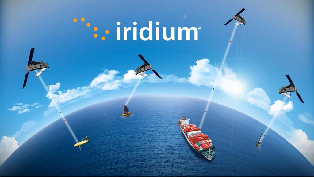
11 Global mobile satellite communications system, with voice and data solutions 66 satellites : world's largest commercial satellite constellation Satellites are cross linked : data calls are relayed from one satellite to another until the Gateway in Arizona, USA. Global + continuous coverage = real time satellite system Low Earth Orbit (LEO) = 780 km altitude The Iridium satellite system uses a frequency in L band ( MHz)
 SIM less Latency 5 20 sec Invoicing based on data")


12 Usage < 100 kbytes / month Short messages (up to 2 kbytes for largest modems) SIM less Latency 5 20 sec Invoicing based on data usage (kbytes/month) Iridium satellites Data are received in binary or text format in attached file (.sbd) USER #N<5 Science platform Iridium Gateway CLS Iridium account CLS processing center Web display Decoding Archiving Monitoring GTS distribution CLS value added services


13 GTS processing & insertion GTS processing and distribution for all met. & ocean platforms, including main international programs Real time QC according WMO standards, distribution in BUFR formats Cooperation with Météo France and the NOAA for GTS insertion

 USER Platform IR Gateway Host")
14 Usage > 100 KBytes/month End to end IP connection (Internet) All traffic from a group of terminals routed to a unique destination IP Usage: telemetry from floats, gliders, AUVs, weather balloons, drones Invoicing based on call duration (seconds) SIM based Low data rate (2400 bps) Real transfer rate : KB / min Iridium satellites Internet (IP connexion) USER Platform IR Gateway Host server


15 A single secured web site to: View all positions on a map Download all available data export Google Earth files Manage users settings Copy other users & create guest accounts Web services (M2M)

16 Online data consumption : for all services (SBD, RUDIC, CSD, etc.)


17 Ruggedized, water proof Iridium SBD modem with GPS (+ internet + Wifi + 3G/4G) Use case for AWS? Enter visual observations Data Automatically collected (NMEA 2000 bus)
18 Thank you! Sophie Baudel
19 The FUTURE : Iridium Next Project for 81 satellites The new constellation will completely replaces the current constellation More bandwidth and higher speeds : up to 1.5 Mbps (vs bps) = increase of x 625! Service continuity & backwards compatibility Expected operationality : end 2018 / beg. 2019

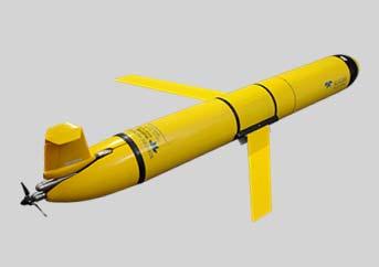
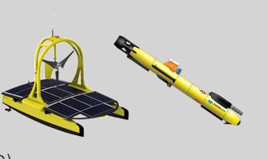

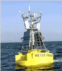
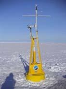
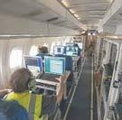
20 METEOROLOGICAL Hydro stations Ice beacons Research aircrafts drones Weather balloons Moored stations OCEANOGRAPHIC Drifting buoys Subsurface Gliders Profiling floats (ARGO) beacons AUV & USV
ARGOS-3: Just Do It. Bill Woodward, CLS America Michel Guigue, CLS Toulouse Christian Ortega, CLS Toulouse
 ARGOS-3: Just Do It Bill Woodward, CLS America Michel Guigue, CLS Toulouse Christian Ortega, CLS Toulouse REMINDER ARGOS-3 FEATURES Sat Pass Prediction Two-Way Communication High Data Rate Managing Transmission,
Overview on Data Collection systems: case of low orbiting satellites
 ITU Seminar for Americas Region Overview on Data Collection systems: case of low orbiting satellites Jean PLA, Frequency Management CNES, Toulouse, FRANCE jean.pla@cnes.fr Michel SARTHOU, ARGOS project
ARGOS satellite system status & improvements
 PAGE 1 ARGOS satellite system status & improvements Yann Bernard CLS, Oceanography AST 14 th meeting, Wellington, New-Zealand METOP-B & SARAL satellites 2 new Argos satellites recently successfully launched!!!
FREQUENCY DECLARATION FOR THE ARGOS-4 SYSTEM. NOAA-WP-40 presents a summary of frequency declarations for the Argos-4 system.
 Prepared by CNES Agenda Item: I/1 Discussed in WG1 FREQUENCY DECLARATION FOR THE ARGOS-4 SYSTEM NOAA-WP-40 presents a summary of frequency declarations for the Argos-4 system. FREQUENCY DECLARATION FOR
Argos Operations Agenda Item 10.3
 Page 1 Argos Operations Agenda Item 10.3 DBCP-30, 27-31 October 2014 Weihai, China Highlights Page 2 ARGOS SPACE SEGMENT Page 3 N18 N19 MetOp A N16 0600 Local time SARAL 1800 Local time N15 MetOp B Future
Sounding the Atmosphere Ground Support for GNSS Radio-Occultation Processing
 Sounding the Atmosphere Ground Support for GNSS Radio-Occultation Processing Atmospheric Sounding René Zandbergen & John M. Dow Navigation Support Office, Ground Systems Engineering Department, Directorate
Analysis of Argos 3 Technology on Buoy Platforms. By L. Braasch, L. Centurioni, C. McCall Scripps Institution of Oceanography, La Jolla, California
 Analysis of Argos 3 Technology on Buoy Platforms By L. Braasch, L. Centurioni, C. McCall Scripps Institution of Oceanography, La Jolla, California Purpose of Study Controlled tests with same host controller
WILDLIFE MONITORING WITH ARGOS by Christian Ortega. Zoology & Satellite Seminar IPEE ASR, Moscou February 2009
 WILDLIFE MONITORING WITH ARGOS by Christian Ortega Zoology & Satellite Seminar IPEE ASR, Moscou 25-26 February 2009 WILDLIFE AND ARGOS Authorizations in Russia (customs, transmission) Tags (choice, testing,
Japanese Argo Program
 PICES XV Oct15, 2006 Japanese Argo Program Nobie Shikama (JAMSTEC) What is Argo? Argo is a global ocean monitoring network of 3,000 floats which measure T-S profile of upper 2,000m every 10 days and transmit
Installation and connection of Galileosky v4.0 tracking devices
 Installation and connection of Galileosky v4.0 tracking devices User Manual www.galileosky.com Contents Necessary Tools, Devices, Materials... 3 General Information... 4 Galileosky v4.0 Tracking Device
RECOMMENDATION ITU-R SA
 Rec. ITU-R SA.1162-1 1 RECOMMENDATION ITU-R SA.1162-1 TELECOMMUNICATION REQUIREMENTS AND PERFORMANCE CRITERIA FOR SERVICE LINKS IN DATA COLLECTION AND PLATFORM LOCATION SYSTEMS IN THE EARTH EXPLORATION-
Chapter 3 Data and Signals
 Computer Networks Al-Mustansiryah University Elec. Eng. Department College of Engineering Fourth Year Class Chapter 3 Data and Signals 3.1 3-3 DIGITAL SIGNALS In addition to being represented by an analog
AIREON SPACE-BASED ADS-B
 AIREON SPACE-BASED ADS-B 2018 Transport Canada Delegates Conference Steve Bellingham Manager, Navigation Systems Engineering Steve.Bellingham@navcanada.ca CNS/ATM Systems Communication Navigation Surveillance
Satellite Oceanography and Monitoring for the Fishing Community
 Tuna 2012 Bangkok Satellite Oceanography and Monitoring for the Fishing Community Presentation by: Chris Wilson Marine Services Who we are Imagery Collection satellite and aerial platforms GeoEye-1 IKONOS
EFBs and Operations: How Connectivity is Changing the Game
 EFBs and Operations: How Connectivity is Changing the Game Moderator: Mark Holmes, Conference Chair and Editorial Director, Avionics and Via Satellite Speakers: Roland Brenny, Principal, Information Technology,
IMO WORLDWIDE RADIONAVIGATION SYSTEM (WWRNS) Study on Communication Techniques for High Accuracy DGPS in the Republic of Korea
 Study on Communication Techniques for High Accuracy DGPS in the Republic of Korea") INTERNATIONAL MARITIME ORGANIZATION E IMO SUB-COMMITTEE ON SAFETY OF NAVIGATION 52nd session Agenda item 12 NAV 52/INF.8 12 May 2006 ENGLISH ONLY WORLDWIDE RADIONAVIGATION SYSTEM (WWRNS) Study on Communication
INTERNATIONAL MARITIME ORGANIZATION E IMO SUB-COMMITTEE ON SAFETY OF NAVIGATION 52nd session Agenda item 12 NAV 52/INF.8 12 May 2006 ENGLISH ONLY WORLDWIDE RADIONAVIGATION SYSTEM (WWRNS) Study on Communication
Status of the COSPAS-SARSAT system and future development integrated in GALILEO. Patrice Brault MARTEC SERPE-IESM
 Status of the COSPAS-SARSAT system and future development integrated in GALILEO Patrice Brault MARTEC SERPE-IESM MARTEC SERPE IESM plant Guidel ARGOS drifter PTR ERIKA Safety of human life actual components
SATELLITE MONITORING OF REMOTE PV-SYSTEMS
 SATELLITE MONITORING OF REMOTE PV-SYSTEMS Stefan Krauter, Thomas Depping UFRJ-COPPE-EE, PV-Labs, C. P. 68504, Rio de Janeiro 21945-970 RJ, BRAZIL Tel: +55-21-2562-8032, Fax: +55-21-22906626, E-mail: krauter@coe.ufrj.br
The Orbcomm Experience
 The Orbcomm Experience Jochen Harms OHB Technology Director of New Ventures Universitätsallee 27-29 28359 Bremen Germany Tel: +49 421 2020 9849 Fax: +49 421 2020 700 Email: harms@ohb-technology.de INTRODUCTION
An Introduction to Airline Communication Types
 AN INTEL COMPANY An Introduction to Airline Communication Types By Chip Downing, Senior Director, Aerospace & Defense WHEN IT MATTERS, IT RUNS ON WIND RIVER EXECUTIVE SUMMARY Today s global airliners use
Solutions Brief 1 KU VS. KA
 Solutions Brief 1 WHY THE RIGHT SATELLITE TECHNOLOGY MATTERS FOR AIRBORNE CONNECTIVITY When selecting a service provider for onboard internet, most aircraft owners rightfully focus on product features,
Workshop Iridium and other comms systems
 Workshop Iridium and other comms systems Roy Stehle & Todd Valentic SRI International Gary Ferentchak Raytheon Polar Services Corp. Seth White UNAVCO Polar Technology Conference Boulder, CO 26 March 2010
Iridium NEXT SensorPODs: Global Access For Your Scientific Payloads
 Iridium NEXT SensorPODs: Global Access For Your Scientific Payloads 25 th Annual AIAA/USU Conference on Small Satellites August 9th 2011 Dr. Om P. Gupta Iridium Satellite LLC, McLean, VA, USA Iridium 1750
Small Satellites: The Execution and Launch of a GPS Radio Occultation Instrument in a 6U Nanosatellite
 Small Satellites: The Execution and Launch of a GPS Radio Occultation Instrument in a 6U Nanosatellite Dave Williamson Director, Strategic Programs Tyvak Tyvak: Satellite Solutions for Multiple Organizations
Delivering More for Less Where You Want It, When You Want It!
 Delivering More for Less Where You Want It, When You Want It! O3b Networks Government Solutions Military Communications and Information Systems Conference (MIlCis) 2013 O3b Networks at a Glance What we
ORBCOMM Machine-To-Machine (M2M)
") ORBCOMM Machine-To-Machine (M2M) Texas V & C-Sigma November 2012 Global M2M Connecting the World s Assets Machine-To-Machine (M2M) Applications Global M2M Wireless Network for Narrowband Data Applications
ORBCOMM Machine-To-Machine (M2M) Texas V & C-Sigma November 2012 Global M2M Connecting the World s Assets Machine-To-Machine (M2M) Applications Global M2M Wireless Network for Narrowband Data Applications
National Report for Canada 27 th Session of the DBCP Geneva Switzerland September th, 2011
 National Report for Canada 27 th Session of the DBCP Geneva Switzerland September 26-30 th, 2011 Chris Marshall Manager of Marine Networks Environment Canada Meteorological Service of Canada DBCP XXVI
Acoustic Communications and Navigation for Mobile Under-Ice Sensors
 DISTRIBUTION STATEMENT A. Approved for public release; distribution is unlimited. Acoustic Communications and Navigation for Mobile Under-Ice Sensors Lee Freitag Applied Ocean Physics and Engineering 266
NAVY SATELLITE COMMUNICATIONS
 NAVY SATELLITE COMMUNICATIONS Item Type text; Proceedings Authors Captain Newell, John W. Publisher International Foundation for Telemetering Journal International Telemetering Conference Proceedings Rights
RockBLOCK+ Developer guide
 RockBLOCK+ Developer guide Version 1.4-12th December 2016 Table of Contents Introduction 3 What is RockBLOCK? 3 About Short Burst Data 3 About Iridium 3 Getting Help 4 Functional Description 4 Power supply
Future Concepts for Galileo SAR & Ground Segment. Executive summary
 Future Concepts for Galileo SAR & Ground Segment TABLE OF CONTENT GALILEO CONTRIBUTION TO THE COSPAS/SARSAT MEOSAR SYSTEM... 3 OBJECTIVES OF THE STUDY... 3 ADDED VALUE OF SAR PROCESSING ON-BOARD G2G SATELLITES...
Amateur Satellite and APRS Data Links. Polar Technology Conference April Bob Bruninga Midns: Kren, Aspholm
 Amateur Satellite and APRS Data Links Polar Technology Conference April 2012 Psat ODTML Ocean Buoys w/ RF Terminals GROUND STATION Bob Bruninga Midns: Kren, Aspholm US Naval Academy Satellite Lab 410-293-6417
NOAA POES PROGRAM On Orbit Satellite Performance
 NOAA POES PROGRAM On Orbit Satellite Performance October 2007 Chris O Connors, NOAA/NESDIS/OSDPD TOPICS STATUS OF OPERATIONAL SATELLITES NOAA-15 through 18 Drift rates and Equator Crossing Times SATELLITE
Emergency Locator Signal Detection and Geolocation Small Satellite Constellation Feasibility Study
 Emergency Locator Signal Detection and Geolocation Small Satellite Constellation Feasibility Study Authors: Adam Gunderson, Celena Byers, David Klumpar Background Aircraft Emergency Locator Transmitters
Satellite Fleet Operations Using a Global Ground Station Network. Naomi Kurahara Infostellar
 Satellite Fleet Operations Using a Global Ground Station Network Naomi Kurahara Infostellar 1 Japanese university satellites Image via University Space Engineering Consortium, http://unisec.jp/wp/wp-content/uploads/2016/06/unisec_satellites_160120_jp_s.jpg
SAR Interferometry Capabilities of Canada's planned SAR Satellite Constellation
 SAR Interferometry Capabilities of Canada's planned SAR Satellite Constellation Dirk Geudtner, Guy Séguin,, Ralph Girard Canadian Space Agency RADARSAT Follow-on Program CSA is in the middle of a Phase
Ground Systems for Small Sats: Simple, Fast, Inexpensive
 Ground Systems for Small Sats: Simple, Fast, Inexpensive but Effective 15 th Ground Systems Architecture Workshop March 1, 2011 Mr Andrew Kwas, Mr Greg Shreve, Northrop Grumman Corp, Mr Adam Yozwiak, Cornell
Review of possible replacement strategies of telecom constellations
 Электронный журнал «Труды МАИ». Выпуск 34 www.mai.ru/science/trudy/ Review of possible replacement strategies of telecom constellations S. Rainjonneau1, J. Cote1, V. Martinot Abstract A bit more than ten
COMMUNICATIONS FOR MARITIME SAFETY AND EFFICIENCY. Francis Zachariae, Secretary-General, IALA
 COMMUNICATIONS FOR MARITIME SAFETY AND EFFICIENCY Francis Zachariae, Secretary-General, IALA IALA and its Purpose Non profit, international technical association established in 1957 Two Goals aimed at
MEO Satellite Applications to Support Mobility
 MEO Satellite Applications to Support Mobility Colloquium on Satellite Services for Global Mobility 14 October, 2013 David Burr, Director, Product Development O3b A revolutionary solution O3b Networks
DHS/U.S. Customs and Border Protection -
 DHS/U.S. Customs and Border Protection - Technology Solutions Program Office (TSPO) DHS/ Unmanned Aircraft System (UAS) October 31, 2006 1 Purpose Provide overall UAS program overview Program Description
Internet based Real-Time Telemetry System for the micro-satellite. in Low Earth Orbit. 1 Introduction
 Internet based Real-Time Telemetry System for the micro-satellite in Low Earth Orbit C. W. Park 1,.G Réhel 1, P. Olivier 2, J. Cimon 2, B. Piyau 1,and L. Dion 2. 1 Université du Québec à Rimouski, Rimouski,
Riza Muhida. Presented at he 22nd Session of the Asia Pacific Regional Space Agency Forum (APRSAF 22), Bali, Indonesia, December 1 4, 2015
, Bali, Indonesia, December 1 4, 2015") Riza Muhida Presented at he 22nd Session of the Asia Pacific Regional Space Agency Forum (APRSAF 22), Bali, Indonesia, December 1 4, 2015 1 Presentation Outline Abstract Background Objective Project Scope
Riza Muhida Presented at he 22nd Session of the Asia Pacific Regional Space Agency Forum (APRSAF 22), Bali, Indonesia, December 1 4, 2015 1 Presentation Outline Abstract Background Objective Project Scope
What we do. Automated Aircraft Data Reporting System Voice & Data on demand for real time decision making
 What we do IRIDIUM System for Voice, Monitor Data, Measure Results & Make Decisions Automated Aircraft Data Reporting System Voice & Data on demand for real time decision making Flight ops Maintenance
O3b A different approach to Ka-band satellite system design and spectrum sharing
 O3b A different approach to Ka-band satellite system design and spectrum sharing ITU Regional Seminar for RCC countries on Prospects for Use of the Ka-band by Satellite Communication Systems, Almaty, Kazakhstan
PAGE 1. Krzysztof Bronk, PhD
 PAGE 1 Krzysztof Bronk, PhD Deputy Manager Wireless Systems and Networks Department National Institute of Telecommunications (NIT), Poland e-mail: K.Bronk@itl.waw.pl Presentation outline PAGE 2 Introduction
TACSAT-2 Target Indicator Experiment (TIE) AIS Payload Overview
 AIS Payload Overview") TACSAT-2 Target Indicator Experiment (TIE) AIS Payload Overview 2007 Maritime Domain Awareness Forum 29 October 2007 NRL_2007-MDAF-29OCT-TIE.1 Christopher Huffine Technical Staff, Code 8120 Naval Research
TACSAT-2 Target Indicator Experiment (TIE) AIS Payload Overview 2007 Maritime Domain Awareness Forum 29 October 2007 NRL_2007-MDAF-29OCT-TIE.1 Christopher Huffine Technical Staff, Code 8120 Naval Research
EMWIN OVERVIEW. Outline
 EMWIN OVERVIEW Thursday, July 10, 2008 Santos Rodriguez NWS EMWIN 1 Outline EMWIN System Description Users of EMWIN EMWIN and the GOES-N Satellite Generation EMWIN and the GOES-R Satellite Generation Project
KONGSBERG SATELLITE SERVICES Earth Observation for Maritime Operations Current Capabilities and Future Potential
 KONGSBERG SATELLITE SERVICES 2017 Earth Observation for Maritime Operations Current Capabilities and Future Potential Andreas Hay Kaljord Project Manager KSAT HQ IN TROMSØ - 69N WELCOME TO TROMSØ Established
Drones operation and generated communication traffic
 Drones operation and generated communication traffic CEPT Workshop on Spectrum for Drones / UAS, Copenhagen, 29-30.05.2018 Christoph Legutko Central and Eastern Europe Director Connectivity Policy Government
University. Federal University of Santa Catarina (UFSC) Florianópolis/SC - Brazil. Brazil. Embedded Systems Group (UFSC)
 Florianópolis/SC - Brazil. Brazil. Embedded Systems Group (UFSC)") University 1 Federal University of Santa Catarina (UFSC) Florianópolis/SC - Brazil Brazil Agenda 2 Partnership Introduction Subsystems Payload Communication System Power System On-Board Computer Attitude
University 1 Federal University of Santa Catarina (UFSC) Florianópolis/SC - Brazil Brazil Agenda 2 Partnership Introduction Subsystems Payload Communication System Power System On-Board Computer Attitude
COSMIC / FormoSat 3 Overview, Status, First results, Data distribution
 COSMIC / FormoSat 3 Overview, Status, First results, Data distribution COSMIC Introduction / Status Early results from COSMIC Neutral Atmosphere profiles Refractivity Temperature, Water vapor Planetary
Dimov Stojče Ilčev. CNS Systems
 Stratospheric Platform Systems (SPS) Presentation by: Dimov Stojče Ilčev Durban University of Technology (DUT) Space Science Centre (SSC) CNS Systems August 2011 SPS for Mobile CNS Applications Stratospheric
SAFE TO SEA (S2S) FOR THE SAFETY OF NAVIGTION.
 FOR THE SAFETY OF NAVIGTION.") SAFE TO SEA (S2S) FOR THE SAFETY OF NAVIGTION. GRAFINTA.S.A. Company founded in 1964 and located in Madrid. With 11 people on our payroll from which 8 are engineers specialized in new technologies and
SAFE TO SEA (S2S) FOR THE SAFETY OF NAVIGTION. GRAFINTA.S.A. Company founded in 1964 and located in Madrid. With 11 people on our payroll from which 8 are engineers specialized in new technologies and
Table 9-1 Operating characteristics of upper-air meteorological monitoring systems. BOUNDARY LAYER VARIABLES RADIOSONDE DOPPLER SODAR
 Table 9-1 VARIABLES p, T, RH Vector winds (WS, WD) Vector winds (WS, WD) Virtual temperature (T v ) Measured Vector winds (WS, WD) u,v,w wind components u,v,w wind components w wind component Altitude
HFIA - August accelerate. persist. perfect.
 Test Results for 2G/3G Communications over Tactical NVIS Links Dr Danie van Wyk (CTO) HFIA - August 2010 accelerate. persist. perfect. Contents: Background Motivation 3G ARCS Products 2G/3G Standards &
ANTARES System Design Iris Public Event, 4-5 February 2013 University of Salzburg Unipark, Salzsburg
 ANTARES System Design Iris Public Event, 4-5 February 2013 University of Salzburg Unipark, Salzsburg 83230917-DOC-TAS-EN-002 Contents 2 SRD requirements and system design Performance requirements and main
CO-OPS Current Sensors Data Telemetry and Formatting
 CO-OPS Current Sensors Data Telemetry and Formatting NOAA/NOS Center for Operational Oceanographic Products and Services User Report IHO Currents Working Group June, 2014 Program Elements 2 Physical Oceanographic
Satcom for Railway Communications - Benefits in a Bearer Flexible Scenario
 Satcom for Railway Communications - Benefits in a Bearer Flexible Scenario ETSI Workshop "Developing the Future Radio for Rail Transport 4-5 July 2018, Sophia Antipolis - France 1 Table of Contents Brief
Satisfying growth demands for offshore communications
 Satisfying growth demands for offshore communications Michael Carter, Sales Director Network and Data Services GVF Oil & Gas Communications Europe 2014, Aberdeen Overview 1. Who we are 2. Key drivers for
Acoustic Communications and Navigation for Mobile Under-Ice Sensors
 DISTRIBUTION STATEMENT A. Approved for public release; distribution is unlimited. Acoustic Communications and Navigation for Mobile Under-Ice Sensors Lee Freitag Applied Ocean Physics and Engineering 266
Smart Meter connectivity solutions
 Smart Meter connectivity solutions BEREC Workshop Enabling the Internet of Things Brussels, 1 February 2017 Vincenzo Lobianco AGCOM Chief Technological & Innovation Officer A Case Study Italian NRAs cooperation
Vaisala DigiCORA Sounding System
 Vaisala DigiCORA Sounding System Leading the world in BUFR messaging All you need to measure the upper air atmospheric profile The Vaisala DigiCORA Sounding System simplifies your daily synoptic observations
Advances in Satellite Communications Technology Suitable for IoT. RRW 18, IoT January 14-15, 2018
 Advances in Satellite Communications Technology Suitable for IoT RRW 18, IoT January 14-15, 2018 Satellite Advances Leading to Higher Capacity and Lower Cost Very large antenna space-deployable reflectors
CJ Jagadeesha,NDRF-IEI, Bangalore RM Vasagam,Chairman Aerospace Division Board,IEI LVM Reddy,Vice-President,IEI
 CJ Jagadeesha,NDRF-IEI, Bangalore RM Vasagam,Chairman Aerospace Division Board,IEI LVM Reddy,Vice-President,IEI D] Geo informatics for assessing EWS in watersheds E] DSS for EW communication and policy
Outline. GPS RO Overview. COSMIC Overview. COSMIC-2 Overview. Summary 9/29/16
 Bill Schreiner and UCAR/COSMIC Team UCAR COSMIC Program Observation and Analysis Opportunities Collaborating with the ICON and GOLD Missions Sept 27, 216 GPS RO Overview Outline COSMIC Overview COSMIC-2
Current and Future Meteorological Satellite Program of China
 Current and Future Meteorological Satellite Program of China ZHANG Wenjian, DONG Chaohua XU Jianmin, YANG Jun China Meteorological Administration May 30, 2005 Beijing, CHINA Outline of the Presentation
Iridium Global PTT. Hardware 9575 PTT & 9523 PTT core module Docking stations from ASE & Beam NI Matrix. Beta testing underway
 Iridium Global PTT Iridium Global PTT Global Push to Talk Voice Service launching in May 2015 Main features Truly global & secure (AES 256) Low latency (
Future of Sustained Observations
 Future of Sustained Observations OceanObs 09 identified tremendous opportunities, significant challenges Called for a framework for planning and moving forward with an enhanced global sustained ocean observing
Direct Readout Acquisition and Relay System for LEO Satellite Data,
 WMO OMM World Meteorological Organization Working together in weather, climate and water Direct Readout Acquisition and Relay System for LEO Satellite Data, (From RARS to DBNet) Jérôme Lafeuille and Mikael
Bluetooth BlueTooth - Allows users to make wireless connections between various communication devices such as mobile phones, desktop and notebook comp
 ECE 271 Week 8 Bluetooth BlueTooth - Allows users to make wireless connections between various communication devices such as mobile phones, desktop and notebook computers - Uses radio transmission - Point-to-multipoint
Sharing scenarios of 5G (IMT-2020) networks with the incumbent and future satellite communication systems
 networks with the incumbent and future satellite communication systems") Sharing scenarios of 5G (IMT-2020) networks with the incumbent and future satellite communication systems AGENDA Past and Present: IMT VS. FSST AGENDA 5GT Satellite Communications Future: IMT AND FSST
Sharing scenarios of 5G (IMT-2020) networks with the incumbent and future satellite communication systems AGENDA Past and Present: IMT VS. FSST AGENDA 5GT Satellite Communications Future: IMT AND FSST
Development of Microsatellite to Detect Illegal Fishing MS-SAT
 Development of Microsatellite to Detect Illegal Fishing MS-SAT Ernest S. C. P. Bintang A.S.W.A.M. Department of Aerospace Engineering Faculty of Mechanical and Aerospace Engineering Institut Teknologi
Information furnished in conformity with the Convention on Registration of Objects Launched into Outer Space
 United Nations Secretariat Distr.: General 9 September 2003 Original: English Committee on the Peaceful Uses of Outer Space Information furnished in conformity with the Convention on Registration of Objects
Lecture 3: Transmission Media
 Lecture 3: Transmission Media Dr. Mohd Nazri Bin Mohd Warip High Performance Broadband Networks Research Group Embedded, Networks and Advanced Computing Research Cluster School of Computer and Communication
Technical Report Analysis of SSMIS data. Eva Howe. Copenhagen page 1 of 16
 Analysis of SSMIS data Eva Howe Copenhagen 9 www.dmi.dk/dmi/tr08-07 page 1 of 16 Colophon Serial title: Technical Report 08-07 Title: Analysis of SSMIS data Subtitle: Author(s): Eva Howe Other contributors:
Satellites and autonomous robots: The future for Arctic observations
 Satellites and autonomous robots: The future for Arctic observations Jeremy Wilkinson British Antarctic Survey jpw28@bas.ac.uk Polarforskningskonferencen 2016 DTU, Oticon Salen, Anker Engelunds Vej 1,
Utilizing Nano Satellites for Water Monitoring for Nile River
 Utilizing Nano Satellites for Water Monitoring for Nile River November 23 rd, 2013 USER: Ashraf Nabil Rashwan, Cairo University, Egypt DEVELOPER: Ayumu Tokaji, University of Tokyo/Keio University, Japan
Proud supporter of the IRMF and the G4 - International Maritime Mass Rescue Conference
 Proud supporter of the IRMF and the G4 - International Maritime Mass Rescue Conference - 2017 Corporate Presentation 6/27/2017 1 OROLIA PROFILE $100m Founded in October 2006 in France, Head Office in Washington
Demonstration of Decimeter-level Real-time Positioning of an Airborne Platform
 Demonstration of Decimeter-level Real-time Positioning of an Airborne Platform M. Armatys, R. Muellerschoen, Y. Bar-Sever, R. Meyer JPL, California Institute of Technology ION NTM 2003 22-24 Jan 2003 Outline
SSC99-VI th AIAA/USU Conference on Small Satellites. Dr. Stephen Horan
 SSC99-VI-7 Three Corner Sat Constellation New Mexico State University: Communications, LEO Telecommunications Services, Intersatellite Communications, and Ground Stations and Network S. Horan and B. Anderson
Comparison of Collision Avoidance Systems and Applicability to Rail Transport
 Comparison of Collision Avoidance Systems and Applicability to Rail Transport Cristina Rico García, Andreas Lehner, Thomas Strang and Matthias Röckl Institute of Communication and Navigation Page 1 Cristina
Operationally Responsive Satellite System CuSat - Nanosat with an Attitude
 Operationally Responsive Satellite System CuSat - Nanosat with an Attitude Presenters: Mr. Greg Shreve, Northrop Grumman Corp. Mr. Andrew Kwas, Northrop Grumman Corp. Co author: Mr. Albert Ren, Cornell
Recent Developments in NOAA s Real- Time Coastal Observing Systems for Safe and Efficient Maritime Transportation
 Recent Developments in NOAA s Real- Time Coastal Observing Systems for Safe and Efficient Maritime Transportation Rich Edwing, Director NOAA Center for Operational Oceanographic Products and Services CMTS
Tide & Meteorological Data over AIS
 Tide & Meteorological Data over AIS E.F.Read (Ohmex Ltd) & W.S.Heaps (ABP Ltd) THSUK Hydro8 1 Background to AIS Most significant development since RADAR Positions and Timing from GPS network 12.5 Watt
USNA-0601 ParkinsonSAT Remote Data Relay (Psat) Cubesat Conference Aug 2012
 Cubesat Conference Aug 2012") USNA-0601 ParkinsonSAT Remote Data Relay (Psat) Cubesat Conference Aug 2012 Psat BRICsat Ocean Buoys w/ RF Terminals GROUND STATION Data Exfiltration Bob Bruninga Midns: Buck, Kimball, Lung, Mahelik, Rehume,
USNA-0601 ParkinsonSAT Remote Data Relay (Psat) Cubesat Conference Aug 2012 Psat BRICsat Ocean Buoys w/ RF Terminals GROUND STATION Data Exfiltration Bob Bruninga Midns: Buck, Kimball, Lung, Mahelik, Rehume,
Feb 7, 2018 A potential new Aeronautical Mobile Satellite Route Service system in the 5 GHz band for the RPAS C2 link ICAO WRC19 Workshop, Mexico
 Feb 7, 2018 A potential new Aeronautical Mobile Satellite Route Service system in the 5 GHz band for the RPAS C2 link ICAO WRC19 Workshop, Mexico City, Mexico Command and Control (C2) link 2 RPA Command
Wireless Communications
 2. Physical Layer DIN/CTC/UEM 2018 Periodic Signal Periodic signal: repeats itself in time, that is g(t) = g(t + T ) in which T (given in seconds [s]) is the period of the signal g(t) The number of cycles
Regional and Inter-Regional Seminar and Workshop on Search and Rescue
 Regional and Inter-Regional Seminar and Workshop on Search and Rescue Mahe, Seychelles 19-22 July 2016 1 Agenda Aireon Introduction Space-Based ADS-B Overview Aireon System Deployment Status Aireon ALERT
Recommended Iridium SBD dataformats for buoys
 Recommended Iridium SBD dataformats for buoys By Pierre Blouch, Christophe Billon, Paul Poli, Météo-France Version 1.7 28 June 2018 The present document describes a list of dataformats which should be
Chapter 2. Physical Layer
 Chapter 2 Physical Layer Lecture 1 Outline 2.1 Analog and Digital 2.2 Transmission Media 2.3 Digital Modulation and Multiplexing 2.4 Transmission Impairment 2.5 Data-rate Limits 2.6 Performance Physical
Telemetry formats and equations of Painani-2 Satellite
 Telemetry formats and equations of Painani-2 Satellite Uplink and Downlink telemetry commands have a special format. This commands have 2 as header (the header always will be the same, it is M, X in ASCII
ITU/WMO Seminar Use of Radio Spectrum for Meteorology: Weather, Water and Climate Monitoring and Prediction
 ITU/WMO Seminar Use of Radio Spectrum for Meteorology: Weather, Water and Climate Monitoring and Prediction Session 5: Meteorological Aids Service (Radiosondes( Radiosondes) ) and Other Systems 5.1.1 MetAids)
tethered balloons stratospheric balloons equipped envelope for Stratobus TM airships thermal protections for satellites
 tethered balloons stratospheric balloons equipped envelope for Stratobus TM airships thermal protections for satellites RELIABLE. PERSISTENT. MULTIPURPOSE. ADAPTABLE. airstar aerospace products ranges
A Shallow Water Acoustic Network for Mine Countermeasures Operations with Autonomous Underwater Vehicles
 A Shallow Water Acoustic Network for Mine Countermeasures Operations with Autonomous Underwater Vehicles Lee Freitag, Matthew Grund, Chris von Alt, Roger Stokey and Thomas Austin Woods Hole Oceanographic
COSPAS-SARSAT System Evolution and Enhancement. MEOSAR System. Emilia Melián Martínez Head of SPMCC Cospas-Sarsat Spain
 COSPAS-SARSAT System Evolution and Enhancement Gijón, Spain MEOSAR System Emilia Melián Martínez Head of SPMCC Cospas-Sarsat Spain Source: CNES D. Ducros COSPAS-SARSAT PROGRAMME IT S ABOUT SAVING LIVES
Challenges and Solutions for GPS Receiver Test
 Challenges and Solutions for GPS Receiver Test Presenter: Mirin Lew January 28, 2010 Agenda GPS technology concepts GPS and GNSS overview Assisted GPS (A-GPS) Basic tests required for GPS receiver verification
Satellite Communications. Chapter 9
 Satellite Communications Chapter 9 Satellite-Related Terms Earth Stations antenna systems on or near earth Uplink transmission from an earth station to a satellite Downlink transmission from a satellite
Satellite Communications. Chapter 9
 Satellite Communications Chapter 9 Satellite-Related Terms Earth Stations antenna systems on or near earth Uplink transmission from an earth station to a satellite Downlink transmission from a satellite
MARITIME SERVICE >> GOING GLOBAL
 EUTELSAT@SEA MARITIME SERVICE >> GOING GLOBAL KU-BAND COVERAGE current coverage future coverage Eutelsat@Sea - Going Global Our maritime services first commercialised in 1990 with EutelTracs, providing