Proud supporter of the IRMF and the G4 - International Maritime Mass Rescue Conference
|
|
|
- Linette Harrison
- 5 years ago
- Views:
Transcription

1 Proud supporter of the IRMF and the G4 - International Maritime Mass Rescue Conference Corporate Presentation 6/27/2017 1


2 OROLIA PROFILE $100m Founded in October 2006 in France, Head Office in Washington DC, incorporated in 7 countries 400 Employees including 100 in R&D and Projects Revenue Sales in 85 countries Worldwiderenowned brands in target segments Acquisitions since Incorporation 9 Corporate Presentation 6/27/2017 2


3 SAR Innovation: MEOSAR Corporate Presentation 6/27/2017 3


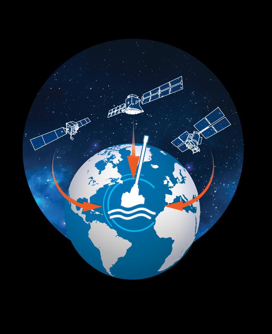
4 ACCELERATED RESCUE WITH MEOSAR MEOSAR Footprint LEOSAR GEOSAR Footprint Corporate Presentation 6/27/2017 4

5 MEOSAR - TIME FRAMES AND IMPACT MEOSAR: Next steps 72 new satellites by 2020 Galileo offers Return Link Service by 2019 New ground infrastructure ongoing Impact First Phase Faster detection of 406 alerts Faster & more accurate location Ability to send return messages Multiple GNSS sources Impact Second Phase Near instantaneous alerts Near instantaneous location Location accuracy without requiring GNSS Corporate Presentation 6/27/2017 5


6 THE DEVELOPMENT OF MEOSAR Medium-altitude Earth Orbit Search & Rescue System McMurdo system installations around the world. McMurdo is installing the UK MCA s MEOSAR network Over 100 channels of MEOSAR antennas to be installed in the next 12 months McMurdo has installed dozens of LUTs, MCCs, and RCCs MEOSAR is on average 46 minutes faster detection compared to LEOSAR MEOSAR combined with Second Generation 406Mhz beacons is gaming changing for the performance of COSPAS SARSAT. Corporate Presentation 6/27/2017 6


7 MEOSAR FIRST ASSISTED RESCUE First life saved through next-generation MEOSAR search and rescue network! Don Stevens, a 53-year-old teacher from Wellington, New Zealand Rescue Coordination Centre New Zealand Manager Mike Hill, said: The extra time created by receiving the signal faster was invaluable and potentially lifesaving Corporate Presentation 6/27/2017 7

8 Beacon Innovation: Artisanal Fishing Corporate Presentation 6/27/2017 8


9 MASS RESCUE & ARTISANAL FISHING It is estimated 25,000 artisanal die every year 2015 Bangladesh tropical storm killed nearly 300 fishermen in one village New Omnicom Solar technology allows Warning Communications Vessel Tracking SAR requests Corporate Presentation 6/27/2017 9


10 SOLAR POWERED BEACONS Self contained solar power supply Global high capacity network coverage via Iridium or RPMA Compete beacon portability SAR Distress alerting & GPS tracking Corporate Presentation 6/27/
11 Coordination Innovation: Prisma Command & Control Corporate Presentation 6/27/


12 SARSAT RESCUE COORDINATION CENTRE SYSTEM Prisma RCCNET provides networked based access to SAR data and rescue planning and coordination functions. Functionality SAR data management functions Rescue planning and coordination MCC-RCC Communications Data archiving Distributed access to all data and functions Corporate Presentation 6/27/
13 MCMURDO PRISMA PRISMA Security and Safety Management Platform PRISMA MCCnet /RCCnet COSPAS-SARSAT compliant MCC/RCC solution Search planning tool w/automated data integration MEOLUT ready Automatic processing of beacon alerts & messages Provides an implementation of the COSPAS-SARSAT Mission Control Center draft standards for the D&E MEOSAR phase PRISMA TMAC Coastal Surveillance System for National Defense Complete command and control interface Interface to all major Radar and High-End surveillance camera vendors Flexible hub and spoke architecture Integration of airborne and waterborne tech (UAV & AUV) Sensor fusion Complex configurable analytics Data mining PRISMA Connect Web-based fleet management solution Multi network routing (sat, GSM, AIS, etc.) User access management Advanced geospatial features Transas electronic charts Private map overlays Management of thousands of devices Monitoring of airtime usage Secure Interconnect APIs Corporate Presentation 6/27/

14 PRISMA - VESSEL TRACKING. Zone Alerting Vessels of Interest Vessel Information Corporate Presentation 6/27/

15 Thank You! Corporate Presentation 6/27/
An Introduction to INDUSTRY PARTNERS 25/05/2017. Military Army & Air Force. Government Defense & Rescue. Aviation Maritime Military. Other.
 An Introduction to 1 INDUSTRY PARTNERS Aviation Maritime Military Coast Guard & Navy Military Army & Air Force Government Defense & Rescue Other Commercial Commercial/Workboat Navy Air Force SAR Agencies
The Future of Search & Rescue. We Save Lives. Steve Waters SAFE Symposium 2016
 The Future of Search & Rescue We Save Lives Steve Waters SAFE Symposium 2016 Covering today.. Understanding the Search and Rescue Ecosystem Helios and GADSS Global Aeronautical Distress and Safety System
MEOSAR & GPS ICG WG-B Vienna Austria, June 2016
 MEOSAR & GPS ICG WG-B Vienna Austria, June 2016 Dr. Lisa Mazzuca, Mission Manager NASA Search and Rescue Office Goddard Space Flight Center 1 Overview Cospas-Sarsat System GNSS-enabled Medium Earth Orbit
Status of the COSPAS-SARSAT system and future development integrated in GALILEO. Patrice Brault MARTEC SERPE-IESM
 Status of the COSPAS-SARSAT system and future development integrated in GALILEO Patrice Brault MARTEC SERPE-IESM MARTEC SERPE IESM plant Guidel ARGOS drifter PTR ERIKA Safety of human life actual components
International Cospas-Sarsat Programme : From operations to MEOSAR prospects
 International Cospas-Sarsat Programme : From operations to MEOSAR prospects Presented by Jean-Charles CORNILLOU MRCC Corsen director with the help of Michel MARGERY (CNES) & Alex GENICOT (FMCC) UN/USA
Press Kit - Sept. 2 nd McMurdo Group s Techno-Sciences, Inc. Chosen for Australia/ New Zealand MEOSAR Infrastructure Deployment
 Press Kit - Sept. 2 nd 2014 McMurdo Group s Techno-Sciences, Inc. Chosen for Australia/ New Zealand MEOSAR Infrastructure Deployment 13 Million+ Deal is Asia Pacific s First Installation of Next-Generation
COSPAS-SARSAT System Evolution and Enhancement. MEOSAR System. Emilia Melián Martínez Head of SPMCC Cospas-Sarsat Spain
 COSPAS-SARSAT System Evolution and Enhancement Gijón, Spain MEOSAR System Emilia Melián Martínez Head of SPMCC Cospas-Sarsat Spain Source: CNES D. Ducros COSPAS-SARSAT PROGRAMME IT S ABOUT SAVING LIVES
Scilab and the CelestLab Toolbox for Testing of the MEOSAR Satellite System
 Scilab and the CelestLab Toolbox for Testing of the MEOSAR Satellite System ScilabTEC 2014 Benoît HELIN Cospas-Sarsat Secretariat www.cospas-sarsat.int Summary The Cospas-Sarsat Programme Demonstration
SAFELINK EPIRB (WITH GPS) 406 Beacon Specification. Meets the requirements of international standards:
 406 Beacon Specification. Meets the requirements of international standards:") SAFELINK EPIRB (WITH GPS) 406 Beacon Specification Meets the requirements of international standards: IEC 61097 2 2008, IEC/EN 60945 Fourth edition (2002 08), ETSI 300 066 v1.3.1 (2001 01), RTCM SC110
SAFELINK EPIRB (WITH GPS) 406 Beacon Specification Meets the requirements of international standards: IEC 61097 2 2008, IEC/EN 60945 Fourth edition (2002 08), ETSI 300 066 v1.3.1 (2001 01), RTCM SC110
Trusted for Life TM. USCG AIS Mandate. 3 rd December 10:30 am - 11:15 am
 Trusted for Life TM USCG AIS Mandate 3 rd December 10:30 am - 11:15 am The AIS Mandate McMurdo Stand 2335 CEO McMurdo UK McMurdo By the Numbers 25% Percentage of world s 406MHz beacons manufactured by
SARSAT Overview. SAR Controllers Training March 2015 Christopher O Connors NOAA SARSAT Program Manager
 SARSAT Overview SAR Controllers Training 2015 3 5 March 2015 Christopher O Connors NOAA SARSAT Program Manager Agenda Cospas-Sarsat System Description User Segment (Beacons) Space Segment Ground Segment
MEOSAR Performance Overview. SAR Controllers Training March 2016 Mickey Fitzmaurice NOAA Senior Systems Engineer
 MEOSAR Performance Overview SAR Controllers Training 2016 1 3 March 2016 Mickey Fitzmaurice NOAA Senior Systems Engineer MEOSAR: AN IMPROVED SYSTEM CONCEPT MEO sat at 20,000 km LEO sat at 800-900 km MEO
Future Concepts for Galileo SAR & Ground Segment. Executive summary
 Future Concepts for Galileo SAR & Ground Segment TABLE OF CONTENT GALILEO CONTRIBUTION TO THE COSPAS/SARSAT MEOSAR SYSTEM... 3 OBJECTIVES OF THE STUDY... 3 ADDED VALUE OF SAR PROCESSING ON-BOARD G2G SATELLITES...
SARSAT Overview. SAR Controllers Training March2013. Jesse Reich NOAA Ground Systems Engineer
 SARSAT Overview SAR Controllers Training 2013 19 21 March2013 Jesse Reich NOAA Ground Systems Engineer Agenda Cospas-Sarsat Overview U.S. SARSAT Organization System Description User Segment (Beacons) /
GMDSS modernisation and e-navigation: spectrum needs
 ETSI Workshop "Future Evolution of Marine Communication", 7-8 November 2017, Sophia Antipolis, France GMDSS modernisation and e-navigation: spectrum needs Karlis Bogens BR Terrestrial Services Department
MARITIME RADIO SYSTEMS FOR DISTRESS ALERTING
 Journal of KONES Powertrain and Transport, Vol. 25, No. 1 2018 MARITIME RADIO SYSTEMS FOR DISTRESS ALERTING Karol Korcz Gdynia Maritime University Department of Marine Telecommunication Morska Street 81-87,
ICG-12 Kyoto Japan WG-B December Dr. Lisa Mazzuca
 ICG-12 Kyoto Japan WG-B December 5 2017 Dr. Lisa Mazzuca MEOSAR: SPACE SEGMENT BDS & Cospas-Sarsat: C-S JC-31 (Oct 2017) China Working Papers BDS 406 MHz MEOSAR REPEATER TECHNOLOGY STATUS (JC31-9/2) Executive
Agenda. Importance of SARSAT Cospas-Sarsat System Description. U.S. SARSAT SARSAT Challenges
 SARSAT Overview SAR Controllers Training 2016 February 29 - March 3, 2016 Christopher O Connors NOAA Direct Services Branch Chief/SARSAT Program Manager Agenda Importance of SARSAT Cospas-Sarsat System
Agenda Item 3: Performance framework for Regional Air Navigation Planning and Implementation BRAZILIAN AERONAUTICAL SEARCH AND RESCUE SYSTEM
 GREPECAS/16-IP/13 International Civil Aviation Organization 03/03/11 CAR/SAM Regional Planning and Implementation Group (GREPECAS) Sixteenth Meeting of the CAR/SAM Regional Planning and Implementation
ISU Symposium The Public Face of Space Strasbourg, France February A quiet and sustainable success story.
 ISU Symposium The Public Face of Space Strasbourg, France 16 18 February 2010 The International Cospas-Sarsat Programme: A quiet and sustainable success story Dany St-Pierre Cospas-Sarsat Secretariat ISU
NASA Search and Rescue Cospas-Sarsat MEOSAR, Second Generation Beacons, and DF Receiver with UAS March 23, 2017
 NASA Search and Rescue Cospas-Sarsat MEOSAR, Second Generation Beacons, and DF Receiver with UAS March 23, 2017 Dr. Lisa Mazzuca Mission Manager NASA Search and Rescue Office Goddard Space Flight Center
MEOSAR System. (And Second Gen Beacons) COMNAP SAR Workshop 1-2 June Cheryl Bertoia. Cospas-Sarsat Secretariat Montreal, Canada
 COMNAP SAR Workshop 1-2 June Cheryl Bertoia. Cospas-Sarsat Secretariat Montreal, Canada") MEOSAR System (And Second Gen Beacons) COMNAP SAR Workshop 1-2 June 2016 Cheryl Bertoia Cospas-Sarsat Secretariat Montreal, Canada 2 Participating Countries (May 2016) 4 Parties 26 Ground Segment Providers
MEOSAR System (And Second Gen Beacons) COMNAP SAR Workshop 1-2 June 2016 Cheryl Bertoia Cospas-Sarsat Secretariat Montreal, Canada 2 Participating Countries (May 2016) 4 Parties 26 Ground Segment Providers
Search and Rescue Operations requirements in GNSS
 Search and Rescue Operations requirements in GNSS Abstract: Unquestionably, the achievement of search and rescue operations essentially depends on the time factor therefore, Search and Rescue SAR operations
GNSS Training for ITS Developers. Characterisation of EGNSS performances in relationship with the application requirements
 GNSS Training for ITS Developers Characterisation of EGNSS performances in relationship with the application requirements Table of Content egnss for Application: Main Challenges EGNOS and GALILEO Performances
COSPAS-SARSAT RCC MESSAGE FORMATS. Chris Payne Manager Australian Mission Control Centre
 COSPAS-SARSAT RCC MESSAGE FORMATS Chris Payne Manager Australian Mission Control Centre COSPAS-SARSAT RCC MESSAGE FORMATS References: IAMSAR Manual Vol 2, Appendix B C-S System Interface Description (SID),
Chapter 2. Search and Rescue Systems
 Chapter 2 Search and Rescue Systems Objectives (1 of 4) As they relate to SAR in the United States, describe the general roles of: National SAR Committee (NSARC) National SAR Plan National SAR Supplement
COMMUNICATION SYSTEMS FOR SAFETY AND SECURITY OF SHIPS
 Journal of KONES Powertrain and Transport, Vol. 23, No. 1 2016 COMMUNICATION SYSTEMS FOR SAFETY AND SECURITY OF SHIPS Karol Korcz Gdynia Maritime University, Department of Marine Telecommunication Morska
ION BEACONS EMERGENCY LOCATI. Tel: +33 (0) or Tel: +44 (0)
 or Tel: +44 (0)") Dealer: Tel: +33 (0)2 97 02 49 49 or Tel: +44 (0)23 9262 3900 E-mail: sales.kannad-av@orolia.com www.kannadaviation.com Find us on Facebook Follow us @kannadaviation DISTRIBUTORS AND AGENTS THROUGHOUT
Dealer: Tel: +33 (0)2 97 02 49 49 or Tel: +44 (0)23 9262 3900 E-mail: sales.kannad-av@orolia.com www.kannadaviation.com Find us on Facebook Follow us @kannadaviation DISTRIBUTORS AND AGENTS THROUGHOUT
McMurdo the Brand. Service and Spares. Contents
 McMurdo the Brand McMurdo is a brand of marine safety and emergency location beacon products, manufactured by Orolia Ltd. The brand originated in the 1940 s, and since that date has been involved in designing
European GNSS Applications in H2020
 European GNSS Applications in H2020 Countdown to H2020 12.12.2013, Brussels Carmen Aguilera European GNSS Agency Agenda European GNSS Agency EU-GNSS market potential FP7- experience and results H2020 opportunities
ICAO Inter-regional SAR Workshop 2016
 ICAO Inter-regional SAR Workshop 2016 Global Aeronautical Distress and Safety System (GADSS) - Implications for Search And Rescue Services Dave Edwards U.S. Coast Guard Chairman, International Civil Aviation
Global and Regional Overview of SAR Services 1.2 ICAO Guidelines for SAR Service including COSPAS-SARSAT System
 SAR/NAM/CAR/SAM IP/06 International Civil Aviation Organization 04/05/09 Search and Rescue (SAR) Meeting for the North American, Caribbean and South American Regions (SAR/NAM/CAR/SAM) (Puntarenas, Costa
S-Band: a new space for mobile communication in Europe Orazio Pulvirenti MSS Project Manager Eutelsat Innovation Team
 S-Band: a new space for mobile communication in Europe Orazio Pulvirenti MSS Project Manager Eutelsat Innovation Team Evolutions in Satellite Telecommunication Ground Segments Noordwijk, June 5 th 2008
Integration of AIS functionalities
 Integration of AIS functionalities by John O. Klepsvik FARGIS 05 March 01, 2005 WORLD CLASS through people, technology and dedication WORLD CLASS through people, technology and dedication KONGSBERG March
The Galileo and EGNOS Programmes
 The Galileo and EGNOS Programmes Dominic Hayes European Commission ignss, Gold Coast, 14 July 2015 The European GNSS Programmes 2 Organisation and Contractual Frameworks European Union Member States (28)
Coastal Surveillance. SCANTER Radar Solutions
 Coastal Surveillance SCANTER Radar Solutions Protecting Your Coastlines and Maritime Domain We provide radar coverage of the coastline to detect and track all types of surface vessels and air targets.
S a t e l l i t e T i m e a n d L o c a t i o n. N o v e m b e r John Fischer VP Advanced R&D
 STL - S a t e l l i t e T i m e a n d L o c a t i o n N o v e m b e r 2 0 1 7 John Fischer VP Advanced R&D jfischer@orolia.com 11/28/201 1 7 WHY AUGMENT GNSS? Recent UK Study Economic Input to UK of a
National Data Distribution. SAR Controllers Training March 2016 Dawn D. Anderson ERT, Inc. Chief USMCC
 National Data Distribution SAR Controllers Training 2016 1 3 March 2016 Dawn D. Anderson ERT, Inc. Chief USMCC Overview Data Distribution for the C/S System MEOSAR Data Principles of National Data Distribution
International Civil Aviation Organization
 International Civil Aviation Organization INFORMATION PAPER 05 August 2016 ENGLISH ONLY Agenda item 7 ICAO/IMO JOINT WORKING GROUP ON HARMONIZATION OF AERONAUTICAL AND MARITIME SEARCH AND RESCUE (ICAO/IMO
Communication & Safety at Sea
 Ocean Signal Ltd. Unit 4, Ocivan Way Margate CT9 4NN United Kingdom info@oceansignal.com +44 1843 282930 Communication & Safety at Sea Introducing Ocean Signal The Range Ocean Signal specialises in the
Communication & Safety at Sea
 Communication & Safety at Sea English Introducing Ocean Signal Ocean Signal specialises in the development and manufacture of advanced communication and safety products for the marine market. With one
PROSECUTING 406/121.5 MHZ DISTRESS BEACONS. Table of Contents
 PROSECUTING 406/121.5 MHZ DISTRESS BEACONS Table of Contents 1. Purpose and intended recipients of this document 2. Synopsis 3. 406 MHz Distress Beacon Channels and Radio Frequency Spectrum 4. Limitations
Telesat. May 12,2015. The Hon. David Emerson Chair, Canada Transportation Act Review Secretariat 350 Albert Street, Suite 330 Ottawa, ON K1A0N5
 Telesat May 12,2015 The Hon. David Emerson Chair, Canada Transportation Act Review Secretariat 350 Albert Street, Suite 330 Ottawa, ON K1A0N5 Dear Mr. Emerson, Telesat Canada is pleased to share its views
Galileo Programme Update
 Galileo Programme Update Pieter De Smet, European Commission ICTP Conference, Prague, 10 November, 2014 1 December 2014 The European GNSS Programmes 2 Secure Foundations ü A stable 7 years perspective
GNSS VULNERABILITY AND CRITICAL INFRASTRUCTURE
 GNSS VULNERABILITY AND CRITICAL INFRASTRUCTURE NNF CONFERENCE 24 MAY 2012 Brynjar Hansen Senior adviser Norwegian Space Centre Lars Giske Senior adviser Norwegian Space Centre MULTI GNSS EXTERNAL COOPERATION
PROTECTING GPS/GNSS-RELIANT MILITARY SYSTEMS
 PROTECTING GPS/GNSS-RELIANT MILITARY SYSTEMS John Fischer VP Advanced R&D Jon Sinden Product Manager, Rugged PNT 6/21/2018 ABOUT OROLIA A world leader in assured positioning, navigation and timing (PNT)
New Aspects of Hybrid Satellite Orbits (HSO) Constellations for Global Coverage of Mobile Satellite Communications (MSC)
 Constellations for Global Coverage of Mobile Satellite Communications (MSC)") New Aspects of Hybrid Satellite Orbits (HSO) Constellations for Global Coverage of Mobile Satellite Communications (MSC) Stojce Dimov Ilcev Durban University of Technology (DUT), 133 Bencorrum, 183 Prince
New Aspects of Hybrid Satellite Orbits (HSO) Constellations for Global Coverage of Mobile Satellite Communications (MSC) Stojce Dimov Ilcev Durban University of Technology (DUT), 133 Bencorrum, 183 Prince
Cost Effective Control of your Coastal Waters
 Cost Effective Control of your Coastal Waters Olov Fäst SSC Airborne Systems 2013-07-03 SSC: A comprehensive space industry Founded in 1972 ~650 employees (2012) ~100 M turnover (2012) Since the start
Satellite Oceanography and Monitoring for the Fishing Community
 Tuna 2012 Bangkok Satellite Oceanography and Monitoring for the Fishing Community Presentation by: Chris Wilson Marine Services Who we are Imagery Collection satellite and aerial platforms GeoEye-1 IKONOS
REVISED QUESTIONNAIRE ON SHORE-BASED FACILITIES FOR THE GLOBAL MARITIME DISTRESS AND SAFETY SYSTEM (GMDSS)
") E 4 ALBERT EMBANKMENT LONDON SE1 7SR Telephone: +44 (0)20 7735 7611 Fax: +44 (0)20 7587 3210 MSC.1/Circ.1382/Rev.2 24 June 2013 REVISED QUESTIONNAIRE ON SHORE-BASED FACILITIES FOR THE GLOBAL MARITIME DISTRESS
E 4 ALBERT EMBANKMENT LONDON SE1 7SR Telephone: +44 (0)20 7735 7611 Fax: +44 (0)20 7587 3210 MSC.1/Circ.1382/Rev.2 24 June 2013 REVISED QUESTIONNAIRE ON SHORE-BASED FACILITIES FOR THE GLOBAL MARITIME DISTRESS
International Data Distribution. SAR Controllers Training March 2016 Dawn D. Anderson ERT, Inc. Chief USMCC
 International Data Distribution SAR Controllers Training 2016 1 3 March 2016 Dawn D. Anderson ERT, Inc. Chief USMCC Cospas-SARSAT is designed to: Save lives through Early detection of distress sometimes
Fallback ecall Concept without Mobile Network Access
 Fallback ecall Concept without Mobile Network Access ecall Days 2017 Sebastian Roth, Philipp Seibold, Hamburg, September 2017 IAV 09/2017 TC-F31 SeRh, PhS Status: released 1 Agenda Introduction of IAV
ESA/CNES/ARIANESPACE Service Optique CSG, S. Martin. IGNSS 2018 Sydney
 ESA/CNES/ARIANESPACE Service Optique CSG, S. Martin IGNSS 2018 Sydney GALILEO SERVICES Open Service (OS) Freely accessible service for positioning, navigation and timing Public Regulated Service (PRS)
Protection criteria for Cospas-Sarsat local user terminals in the band MHz
 Recommendation ITU-R M.1731-2 (01/2012) Protection criteria for Cospas-Sarsat local user terminals in the band 1 544-1 545 MHz M Series Mobile, radiodetermination, amateur and related satellite services
GNSS in Maritime and Education in Egypt
 GNSS in Maritime and Education in Egypt GNSS IN MARITIME PORTS SHIPS PORTS WATERWAYS GNSS maritime applications will help to improve: navigation. Ship operations. Traffic management. Seaport operations.
Galileo. Development Status. Navigare'09 à Neuchâtel DR. MARTIN HOLLREISER GALILEO PROJECT OFFICE - EUROPEAN SPACE AGENCY
 Galileo Development Status DR. MARTIN HOLLREISER GALILEO PROJECT OFFICE - EUROPEAN SPACE AGENCY Munich Satellite Navigation Summit 2009 Navigare'09 à Neuchâtel Programme Phases 2011-2013 4 GIOVE A/B IOV
Introduction Objective and Scope p. 1 Generic Requirements p. 2 Basic Requirements p. 3 Surveillance System p. 3 Content of the Book p.
 Preface p. xi Acknowledgments p. xvii Introduction Objective and Scope p. 1 Generic Requirements p. 2 Basic Requirements p. 3 Surveillance System p. 3 Content of the Book p. 4 References p. 6 Maritime
Update on BeiDou Navigation Satellite System
 Update on BeiDou Navigation Satellite System 1 BDS Development 2 Near-term Plans BD-2 System FOC services from December, 2012 (5GEO+5IGSO+4MEO) Two on-orbit backup satellites launched in 2016 (1 IGSO+1
For more than 30 years, since its
 WORKING PAPERS MEOSAR New GNSS Role in Search & Rescue The ESA-built Svalbard Medium-Earth Orbit Local User Terminal (MEOLUT) on Spitsbergen Island, part of an extension of the international Cospas Sarsat
The Future in Marine Radio Communication GMDSS. Department of Transportation United States Coast Guard
 The Future in Marine Radio Communication GMDSS Department of Transportation United States Coast Guard Do you use a Maritime Radio System? If so, the new Global Maritime Distress and Safety System (GMDSS)
ORBCOMM Machine-To-Machine (M2M)
") ORBCOMM Machine-To-Machine (M2M) Texas V & C-Sigma November 2012 Global M2M Connecting the World s Assets Machine-To-Machine (M2M) Applications Global M2M Wireless Network for Narrowband Data Applications
ORBCOMM Machine-To-Machine (M2M) Texas V & C-Sigma November 2012 Global M2M Connecting the World s Assets Machine-To-Machine (M2M) Applications Global M2M Wireless Network for Narrowband Data Applications
It is an Interconnected World. Except in the Maritime Domain In 2008 Satellite AIS (S-AIS) Changed All that!
 Changed All that!") It is an Interconnected World Except in the Maritime Domain In 2008 Satellite AIS (S-AIS) Changed All that! Background This brief is the result of that Research, which continues to this day. Makes Regional
It is an Interconnected World Except in the Maritime Domain In 2008 Satellite AIS (S-AIS) Changed All that! Background This brief is the result of that Research, which continues to this day. Makes Regional
Airborne Satellite Communications on the Move Solutions Overview
 Airborne Satellite Communications on the Move Solutions Overview High-Speed Broadband in the Sky The connected aircraft is taking the business of commercial airline to new heights. In-flight systems are
Market strategy update in Maritime segment. This presentation can be interpreted only together with the oral comments accompanying it
 Market strategy update in Maritime segment This presentation can be interpreted only together with the oral comments accompanying it 2 Market sub-segments and applications Recreational navigation: GNSS
IMO WORLD-WIDE RADIONAVIGATION SYSTEM (WWRNS) GALILEO receiver performance standards. Submitted by the European Commission
 GALILEO receiver performance standards. Submitted by the European Commission") INTERNATIONAL MARITIME ORGANIZATION E IMO SUB-COMMITTEE ON SAFETY OF NAVIGATION 50th session Agenda item 13 2 April 2004 Original: ENGLISH WORLD-WIDE RADIONAVIGATION SYSTEM (WWRNS) GALILEO receiver performance
INTERNATIONAL MARITIME ORGANIZATION E IMO SUB-COMMITTEE ON SAFETY OF NAVIGATION 50th session Agenda item 13 2 April 2004 Original: ENGLISH WORLD-WIDE RADIONAVIGATION SYSTEM (WWRNS) GALILEO receiver performance
Galileo Performance Update Rafael Lucas European Space Agency
 Galileo Performance Update Rafael Lucas European Space Agency United Nations/Argentina Workshop on the Applications of GNSS 19-23 March 2018, Falda del Carmen, Argentina ESA UNCLASSIFIED - For Official
FOURTH SESSION OF THE SUB-COMMITTEE ON NAVIGATION, COMMUNICATIONS AND SEARCH AND RESCUE 6 to 10 March 2017
 INTERNATIONAL REGULATIONS COMMISSION BRIEF FOURTH SESSION OF THE SUB-COMMITTEE ON NAVIGATION, COMMUNICATIONS AND SEARCH AND RESCUE 6 to 10 March 2017 1 GENERAL The Sub-Committee on Navigation, Communications
Search and Rescue Satellite Aided Tracking (SARSAT) Program Plan. Version 2.1 March 6, 2007
 Program Plan. Version 2.1 March 6, 2007") . Search and Rescue Satellite Aided Tracking (SARSAT) Program Plan Version 2.1 March 6, 2007 . - Page Intentionally Left Blank . Document History Version Revision Date Revised Pages Comments 1 0 October
. Search and Rescue Satellite Aided Tracking (SARSAT) Program Plan Version 2.1 March 6, 2007 . - Page Intentionally Left Blank . Document History Version Revision Date Revised Pages Comments 1 0 October
GMDSS for Recreational Boaters
 GMDSS for Recreational Boaters OVERVIEW The Global Maritime Distress and Safety System (GMDSS) is an international system using advanced communications technology. Development of GMDSS was initiated by
Marine Monitor (M ) A Low Cost Radar Solution for Monitoring Nearshore Marine Protected Areas
 A Low Cost Radar Solution for Monitoring Nearshore Marine Protected Areas") 2 Marine Monitor (M ) A Low Cost Radar Solution for Monitoring Nearshore Marine Protected Areas 1 Problem The number of Marine Protected Areas (MPAs) are increasing globally making it challenging to effectively
2 Marine Monitor (M ) A Low Cost Radar Solution for Monitoring Nearshore Marine Protected Areas 1 Problem The number of Marine Protected Areas (MPAs) are increasing globally making it challenging to effectively
IDENTIFICATION AND RECOVERY SYSTEM FOR SUBMARINE FLEETS S-10 SUBMARINE BEACON. ORCA S10 User Manual
 IDENTIFICATION AND RECOVERY SYSTEM FOR SUBMARINE FLEETS SUBMARINE BEACON S-10 ORCA S10 User Manual BriarTek, Inc. Technical Support: 703.548.7892 Email: support@briartek.com Web: www.briartek.com 2018
ESA/CNES/ARIANESPACE-Service Optique CSG, S. Martin ABUJA, OCTOBER 2018
 ESA/CNES/ARIANESPACE-Service Optique CSG, S. Martin ABUJA, OCTOBER 2018 GALILEO - SOME KEY FEATURES CIVIL Not managed by Defence DUAL FREQUENCY (L1/L5 ) Less impact from solar conditions/ionosphere DIGITAL
Dimov Stojče Ilčev. CNS Systems
 Stratospheric Platform Systems (SPS) Presentation by: Dimov Stojče Ilčev Durban University of Technology (DUT) Space Science Centre (SSC) CNS Systems August 2011 SPS for Mobile CNS Applications Stratospheric
Satellite navigation applications: opportunities from the European GNSS. Fiammetta Diani Deputy Head of Market Development European GNSS Agency
 Satellite navigation applications: opportunities from the European GNSS Fiammetta Diani Deputy Head of Market Development European GNSS Agency FP7 success story in Lithuania COSUDEC Coastal Surveying of
Emergency Locator Signal Detection and Geolocation Small Satellite Constellation Feasibility Study
 Emergency Locator Signal Detection and Geolocation Small Satellite Constellation Feasibility Study Authors: Adam Gunderson, Celena Byers, David Klumpar Background Aircraft Emergency Locator Transmitters
Implementation and introduction of the COSPAS SARSAT system in South Africa
 Implementation and introduction of the COSPAS SARSAT system in South Africa Dirk Cornelissen Network Centre Operations - Maritime Telkom SA Limited November 2006 What is the COSPAS SARSAT programme? International
Author s Name Name of the Paper Session. DYNAMIC POSITIONING CONFERENCE October 10-11, 2017 SENSORS SESSION. Sensing Autonomy.
 Author s Name Name of the Paper Session DYNAMIC POSITIONING CONFERENCE October 10-11, 2017 SENSORS SESSION Sensing Autonomy By Arne Rinnan Kongsberg Seatex AS Abstract A certain level of autonomy is already
Global navigation satellite systems (GNSS) - European Galileo system
 - European Galileo system") L E C T U R E 5 Global navigation satellite systems (GNSS) - European Galileo system Lecture 5 Overview Galileo GNSS Development Architecture Principle EGNOS GNSS applications GALILEO system GALILEO system
L E C T U R E 5 Global navigation satellite systems (GNSS) - European Galileo system Lecture 5 Overview Galileo GNSS Development Architecture Principle EGNOS GNSS applications GALILEO system GALILEO system
Global Maritime Distress and Safety System (GMDSS)
") Global Maritime Distress and Safety System (GMDSS) Global Maritime Distress and Safety System (GMDSS) BACKGROUNG, APPLICATION, DEFINITION GMDSS (Background) SOLAS 74 Ships 1600 TRG Radio Installation Ships
Global Maritime Distress and Safety System (GMDSS) Global Maritime Distress and Safety System (GMDSS) BACKGROUNG, APPLICATION, DEFINITION GMDSS (Background) SOLAS 74 Ships 1600 TRG Radio Installation Ships
720 VHF/UHF 80 to 500 MHz Maritime and Coastal Surveillance
 720 VHF/UHF 80 to 500 MHz Maritime and Coastal Surveillance Radio Direction Finding (RDF) System The TCI Model 720 is a high-performance radio direction finder that can be easily integrated into maritime
New Funding Opportunities to Support Safety of Navigation: EGNOS and Galileo
 New Funding Opportunities to Support Safety of Navigation: EGNOS and Galileo e-navigation Underway 31 January-2 February 2017 GSA 2016 The European GNSS Agency (GSA) today: Staff: about 145 Nationalities:
MINIMIZING DELAYS IN SEARCH AND RESCUE RESPONSE TO DISTRESS ALERTS
 INTERNATIONAL MARITIME ORGANIZATION 4 ALBERT EMBANKMENT LONDON SE1 7SR Telephone: 020 7735 7611 Fax: 020 7587 3210 IMO E Ref. T2-OSS/1.4 MSC.1/Circ.1248 16 October 2007 MINIMIZING DELAYS IN SEARCH AND
L AGENCE NATIONALE DES FREQUENCES (ANFR) From Titanic to satellite from Morse to digital Entry in a new era for the maritime community
 From Titanic to satellite from Morse to digital Entry in a new era for the maritime community") L AGENCE NATIONALE DES FREQUENCES (ANFR) From Titanic to satellite from Morse to digital Entry in a new era for the maritime community ITU regional seminar 6-8 June 2018 St-Petersburg, Russian Federation
L AGENCE NATIONALE DES FREQUENCES (ANFR) From Titanic to satellite from Morse to digital Entry in a new era for the maritime community ITU regional seminar 6-8 June 2018 St-Petersburg, Russian Federation
Development of Microsatellite to Detect Illegal Fishing MS-SAT
 Development of Microsatellite to Detect Illegal Fishing MS-SAT Ernest S. C. P. Bintang A.S.W.A.M. Department of Aerospace Engineering Faculty of Mechanical and Aerospace Engineering Institut Teknologi
Earth Observation at Spin.Works
 Earth Observation at Spin.Works H2020 Space Information Day Lisboa September 29, 2016 Spin.Works, S.A. Av. Da Igreja nº42 6º 1700-239 Lisboa Phone/Fax +351 21 012 8452 info@spinworks.pt www.spinworks.pt
EUROPEAN GNSS ADOPTION OPPORTUNITIES IN TRANSPORT WITH FOCUS ON RAIL
 EUROPEAN GNSS ADOPTION OPPORTUNITIES IN TRANSPORT WITH FOCUS ON RAIL Gian Gherardo Calini European GNSS Agency III Workshop GNSS Technology Advances in a Multi-Constellation Framework 22 January 2016 This
QUESTIONNAIRE ON SHORE-BASED FACILITIES FOR THE GLOBAL MARITIME DISTRESS AND SAFETY SYSTEM (GMDSS)
") E 4 ALBERT EMBANKMENT LONDON SE1 7SR Telephone: +44 (0)20 7735 7611 Fax: +44 (0)20 7587 3210 Ref. T2-OSS/2.6 MSC.1/Circ.1382 3 December 2010 QUESTIONNAIRE ON SHORE-BASED FACILITIES FOR THE GLOBAL MARITIME
E 4 ALBERT EMBANKMENT LONDON SE1 7SR Telephone: +44 (0)20 7735 7611 Fax: +44 (0)20 7587 3210 Ref. T2-OSS/2.6 MSC.1/Circ.1382 3 December 2010 QUESTIONNAIRE ON SHORE-BASED FACILITIES FOR THE GLOBAL MARITIME
Multi Sensor Data Fusion
 Multi Sensor Data Fusion for improved maritime traffic monitoring in the Canadian Arctic Giulia Battistello*, Martin Ulmke*, Javier Gonzalez*, Camilla Mohrdieck** (*) Fraunhofer FKIE Sensor Data and Information
Applying Multisensor Information Fusion Technology to Develop an UAV Aircraft with Collision Avoidance Model
 Applying Multisensor Information Fusion Technology to Develop an UAV Aircraft with Collision Avoidance Model by Dr. Buddy H Jeun and John Younker Sensor Fusion Technology, LLC 4522 Village Springs Run
distributors and agents throughout the world Dealer: Follow
 Dealer: Orolia Ltd Silver Point Airport Service Road Portsmouth PO3 5PB United Kingdom Tel: +44 (0) 23 9262 3900 Fax: +44 (0) 23 9262 3998 E-mail: sales.kannad-ma@orolia.com www.kannadmarine.com Like us
Maritime ISSUE 5. Excerpt from the GNSS MARKET REPORT, ISSUE 5 (2017 ) EDITOR S SPECIAL DRONES
 EDITOR S SPECIAL DRONES") Maritime EDITOR S SPECIAL DRONES ISSUE 5 Excerpt from the GNSS MARKET REPORT, ISSUE 5 (217 ) 58 Maritime Getty images GNSS applications According to the distinction provided by IMO Resolution A.915(22),
Maritime EDITOR S SPECIAL DRONES ISSUE 5 Excerpt from the GNSS MARKET REPORT, ISSUE 5 (217 ) 58 Maritime Getty images GNSS applications According to the distinction provided by IMO Resolution A.915(22),
SSC space expertise on the ground
 SSC space expertise on the ground FMV Sensor Symposium Stockholm, September 2016 Björn Ohlson and Petrus Hyvönen Satellite Services for Surveillance & Reconnaissance Navigation Communication and Space
KONGSBERG SATELLITE SERVICES Earth Observation for Maritime Operations Current Capabilities and Future Potential
 KONGSBERG SATELLITE SERVICES 2017 Earth Observation for Maritime Operations Current Capabilities and Future Potential Andreas Hay Kaljord Project Manager KSAT HQ IN TROMSØ - 69N WELCOME TO TROMSØ Established
AERONAUTICAL AND MARITIME SEARCH AND RESCUE (AMSAR) - TANZANIA. Search and Rescue Organization
 - TANZANIA. Search and Rescue Organization") AERONAUTICAL AND MARITIME SEARCH AND RESCUE (AMSAR) - TANZANIA Search and Rescue Organization TANZANIA SAR ORGANIZATIONAL STRUCTURE MINISTRY OF FINANCE AND ECONOMIC AFFAIRS THE PRIME MINISTER S OFFICE
AERONAUTICAL AND MARITIME SEARCH AND RESCUE (AMSAR) - TANZANIA Search and Rescue Organization TANZANIA SAR ORGANIZATIONAL STRUCTURE MINISTRY OF FINANCE AND ECONOMIC AFFAIRS THE PRIME MINISTER S OFFICE
GALILEO Applications. Andreas Schütz Training on GNSS T131 / T151 Bangkok, January 14th 2019
 GALILEO Applications Andreas Schütz Training on GNSS T131 / T151 Bangkok, January 14th 201 Overview GNSS Downstream Applications overview The GALILEO Open Service The GALILEO Public Regulated Service The
Report of the Working Group B: Enhancement of Global Navigation Satellite Systems (GNSS) Services Performance
 Services Performance") Report of the Working Group B: Enhancement of Global Navigation Satellite Systems (GNSS) Services Performance 1. The Working Group on Enhancement of Global Navigation Satellite Systems (GNSS) Service Performance
Report of the Working Group B: Enhancement of Global Navigation Satellite Systems (GNSS) Services Performance 1. The Working Group on Enhancement of Global Navigation Satellite Systems (GNSS) Service Performance
SARLink Briefing 2016 SAFE Europe Tuesday, 12 April
 SARLink Briefing 2016 SAFE Europe Tuesday, 12 April 2016 1 ACR Electronics, Inc. Corporate Overview Since 1956, ACR has been at the forefront of engineering and manufacturing life saving products 55,000
SAFE TO SEA (S2S) FOR THE SAFETY OF NAVIGTION.
 FOR THE SAFETY OF NAVIGTION.") SAFE TO SEA (S2S) FOR THE SAFETY OF NAVIGTION. GRAFINTA.S.A. Company founded in 1964 and located in Madrid. With 11 people on our payroll from which 8 are engineers specialized in new technologies and
SAFE TO SEA (S2S) FOR THE SAFETY OF NAVIGTION. GRAFINTA.S.A. Company founded in 1964 and located in Madrid. With 11 people on our payroll from which 8 are engineers specialized in new technologies and
GALILEO READY TO LINK WITH INSPIRE
 GALILEO READY TO LINK WITH INSPIRE INSPIRE CONFERENCE 2016 Barcelona 28 September 2016 Alina Hriscu Market Development European GNSS Agency (GSA) Agenda European GNSS Agency (GSA) E GNSS Services, Signals
ACR Electronics, Inc Ravenswood Road Fort Lauderdale, FL New Product Briefing SARLink 406 MHz / Iridium Beacon
 ACR Electronics, Inc. 5757 Ravenswood Road Fort Lauderdale, FL 33312 www.acrartex.com New Product Briefing SARLink 406 MHz / Iridium Beacon Two Powerful Brands One Great Company Our Brands Marine, Aviation,