The Nordic Institute of Navigation (NNF)
|
|
|
- Lionel O’Brien’
- 5 years ago
- Views:
Transcription


1 The Nordic Institute of Navigation (NNF) non-profit, independent and a non-political organization for professionals working within the field of navigation. The focus of NNF is on all aspects of positioning and navigation related to marine, air, land, and space based applications. Special interests lie in e-nav and indoor navigation. 25 companies as corporate members 32 individual members NNF is working to: improve qualifications of professionals within navigation, among other things by aiming at better educational opportunities improve safety for personnel, the environment, and for financial assets dependent on positioning and navigation improve the efficiency and thereby to reduce costs within applications relying on positioning and navigation 1 nnf@nornav.org
")

2 Proof-of-Concept Demonstrator to Improve Safety of Maritime Navigation in the Baltic Sea based on a paper presented at the European Navigation Conference (ENC) 2017 Prof. Heidi Kuusniemi on behalf of Dr. Sarang Thombre Department of Navigation & Positioning Finnish Geospatial Research Institute National Land Survey, Finland
3 Contents Introduction to EU BONUS ESABALT System Architecture Proof-of-Concept Implementation Scenario 1: Oil spill recovery operations Scenario 2: Assisting Multiple Vessels in Distress Scenario 3: Assisting in the Aftermath of SATNAV Signal Jamming ESABALT System Self-analysis Future Outlook Conclusions

4 EU BONUS ESABALT Enhanced Situational Awareness to Improve Maritime Safety in the Baltic
5 EU BONUS ESABALT was a feasibility study funded by the EU BONUS program about an open mechanism for the crowd-sharing (crowdsourcing + sharing) of maritime information for the benefit of all maritime stakeholders in the Baltic Sea Region ships, maritime personnel (ship crews, coast guard, search & rescue, VTS, etc.) and sensor stations are the primary source and beneficiaries of the information information which is critical for enhancing maritime safety & security, environmental monitoring, and emergency response More information at:
6 System Architecture
7 Proof-of-Concept Demo Experimental Set-up and Scenarios ESABALT benefit investigated under three scenarios: Scenario 1: Oil spill recovery operations Scenario 2: Assisting Multiple Vessels in Distress Scenario 3: Assisting in the Aftermath of SATNAV Signal Jamming Simulation equipment: Furuno FFSC- 200 software platform Furuno navigation simulator Navisimu Furuno Finland FICE-100 ice radar Furuno Finland FOIL-200 oil radar Dash-board camera Live ships data from AIS receiver Simulated other vessels using the Navisimu simulator The ESABALT application can be implemented also as a thin-client for use in personal navigation and communication devices, such as tablet computers and smart-phones

8 ESABALT for Small Boats Onboard Equipment

9 ESABALT for Commercial Vessels Onboard Equipment
 A georeferenced picture presented on")
10 Scenario 1: ESABALT benefits in oil spill recovery operations (a) A georeferenced picture presented on GUI
 Oil spill area polygon created in the")
11 Scenario 1: ESABALT benefits in oil spill recovery operations (b) Oil spill area polygon created in the system
 Oil radar picture")
12 Scenario 1: ESABALT benefits in oil spill recovery operations (c) Oil radar picture

13 Scenario 1: ESABALT benefits in oil spill recovery operations (d) Oil spill confirmed area superimposed on original detected polygon
 Planned routes for recovery vessels")
14 Scenario 1: ESABALT benefits in oil spill recovery operations (e) Planned routes for recovery vessels
 Vessel s report of the distress situation using")
15 Scenario 2: ESABALT System for Assisting Multiple Vessels in Distress (a) Vessel s report of the distress situation using ESABALT GUI
 Distress data forwarded to vessels in the")
16 Scenario 2: ESABALT System for Assisting Multiple Vessels in Distress (b) Distress data forwarded to vessels in the vicinity
 Multiple distress messages aggregated in the ESABALT")
17 Scenario 2: ESABALT System for Assisting Multiple Vessels in Distress (c) Multiple distress messages aggregated in the ESABALT system
 ESABALT generated general")
18 Scenario 2: ESABALT System for Assisting Multiple Vessels in Distress (d) ESABALT generated general distress area
 ESABALT user interface in normal operating")
19 Scenario 3: ESABALT System for Assisting in the Aftermath of SATNAV Signal Jamming (a) ESABALT user interface in normal operating conditions
 SATNAV unavailability alert reported to all vessels by the ESABALT")
20 Scenario 3: ESABALT System for Assisting in the Aftermath of SATNAV Signal Jamming (b) SATNAV unavailability alert reported to all vessels by the ESABALT system
 Vessel s position information via AIS transmissions sent by ESABALT")
21 Scenario 3: ESABALT System for Assisting in the Aftermath of SATNAV Signal Jamming (c) Vessel s position information via AIS transmissions sent by ESABALT system
22 System Self-analysis BONUS ESABALT has reached TRL 4 Technology demonstrated in laboratory environment. System analysis based on quality of service factors: reliability, availability, usability, credibility, and security. Economic and non-economic feasibility analysis based on economic, political, social and technological domains. The study proves that ESABALT system is designed to be technologically feasible to implement and economically sustainable to operate within the boundaries of the defined quality of service parameters.
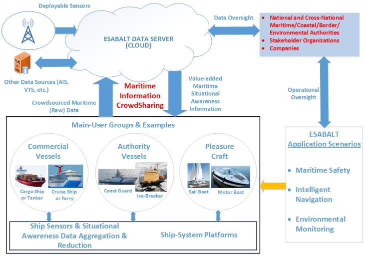
23 Future Outlook Space-Based Remote Sensing Crowdsourced maritime (Raw) Data Aerial Remote Sensing Other Data Sources (AIS, VTS, etc.) Crowdsourced Maritime (Raw) Data Commercial Vessels Near Real-Time Maritime Situational Awareness Platform (Fusion with ESABALT Data) ESABALT DATA SERVER (CLOUD) Maritime Information CrowdSharing Main-User Groups & Examples Authority Vessels Value-added MSA Information Value-added MSA Information Data Oversight Pleasure Craft Advisory Partners (Project Steering Committee) Operational Oversight National and Cross-National Maritime/ Coastal/ Border/ Environmental Authorities Stakeholder Organizations Companies ESABALT Validation Scenarios Maritime Safety Cargo Ship or Tanker Cruise Ship or Ferry Coast Guard Ice-Breaker Sail Boat Motor Boat Intelligent Navigation Ship Sensors & Situational Awareness Data Aggregation & Reduction Ship-System Platforms Environmental Monitoring
24 Conclusions The primary aim of ESABALT is to create a common (international) platform for crowdsourced information exchange to enable cooperation for enhanced maritime safety and security in the Baltic Sea region. Diverse classes of ships and sensors can contribute to and benefit from the data pool. The benefits of ESABALT was demonstrated under three case scenarios simulated using Furuno Finland maritime equipment and software. Feasibility study under economic, political, social, and technological domain prove that the ESABALT system will be sustainable under operational conditions. Future integration with space/aerial remote sensing to increase the temporal and spatial scope of situational awareness in the Baltic Sea.
nls.fi Specialist Research Scientist Department of Navigation & Positioning Finnish Geospatial Research Institute National Land Survey Email: sarang.thombre(at)nls.")
25 ESABALT Prof. Heidi Kuusniemi Dr. Sarang Thombre Director Department of Navigation & Positioning Finnish Geospatial Research Institute National Land Survey heidi.kuusniemi(at)nls.fi Specialist Research Scientist Department of Navigation & Positioning Finnish Geospatial Research Institute National Land Survey sarang.thombre(at)nls.fi Robert Guinness Research Manager Department of Navigation & Positioning Finnish Geospatial Research Institute National Land Survey robert.guinness(at)nls.fi THANK YOU!
Project BONUS ESABALT
 Project BONUS ESABALT Economic and Non-Economic Feasibility Analysis dr Paweł Banaś Maritime University of Szczecin Content Assumptions 1. Analysis of navigational systems and devices 2. Expected ESABALT
Strategic and operational risk management for wintertime maritime transportation system
 Strategic and operational risk management for wintertime maritime transportation system 1. Description of the project s goals and results Final summary BONUS STORMWINDS has the overall objective to enhance
Korea s Strategy for e-navigation. SMART-Navigation. Presented by. Bu Young, Kim. 28 May Ministry of Oceans and Fisheries Republic of Korea
 Korea s Strategy for e-navigation SMART-Navigation Presented by Bu Young, Kim 28 May 2014 Ministry of Oceans and Fisheries Republic of Korea 1 2 3 4 5 6 1. SMART- Navigation? SMART-Navigation Korea s
Satellite services for maritime security
 Satellite services for ITS-T Sophia Antipolis 6 June 2007 Jean-Pierre Cauzac, CLS - Collecte Localisation Satellites 35 Are the seas becoming more dangerous? IMB report 2006 shows improvement: 239 piracy
ESA IAP Blue Belt demonstration project:
 Page 1 ESA IAP Blue Belt demonstration project: supporting the European Maritime Safety Agency (EMSA) Blue Belt Project, by providing a service based on satellite based AIS data complementing the terrestrial
Sensors, Tools and the Common Operating Picture. Sensors, Tools and the Common Operating Picture 14 th April Middleburg
 Sensors, Tools and the Common Operating Picture 14 th April 2015 - Middleburg Aptomar Established in 2005 Owned by Statoil, Investinor, Proventure Seed, Verdane Capitol Have developed and control all IPR
ROUTEING OF SHIPS, SHIP REPORTING AND RELATED MATTERS. New traffic separation schemes and two-way routes in Norra Kvarken
 E SUB-COMMITTEE ON SAFETY OF NAVIGATION 57th session Agenda item 3 NAV 57/3/7 11 March 2011 Original: ENGLISH ROUTEING OF SHIPS, SHIP REPORTING AND RELATED MATTERS New traffic separation schemes and two-way
Navigating the Arctic Rush
 Navigating the Arctic Rush Heidi Kuusniemi Professor, Director Department of Navigation and Positioning Finnish Geospatial Research Institute (FGI), www.fgi.fi President Nordic Institute of Navigation,
Demonstrator of a Data Processing Centre (DPC) for satellite-based AIS services
 for satellite-based AIS services") Page 1 Demonstrator of a Data Processing Centre (DPC) for satellite-based AIS services 19/20 April 2012 gfabritius@cls.fr Overview of the presentation Page 2 Introducing CLS Introducing AIS / SAT-AIS Scope
Page 1 Demonstrator of a Data Processing Centre (DPC) for satellite-based AIS services 19/20 April 2012 gfabritius@cls.fr Overview of the presentation Page 2 Introducing CLS Introducing AIS / SAT-AIS Scope
Vessel Traffic Generator. Agent based maritime traffic generator
 Vessel Traffic Generator Agent based maritime traffic generator Motivation Why (I) Need for data sets to develop and validate Maritime Situational Awareness algorithms Problem Real-world data (e.g. AIS
The Role of Automatic Identification System (AIS) in Enhancing Vessel Traffic Management By Capt. Ehab Ibrahim Etman
 in Enhancing Vessel Traffic Management By Capt. Ehab Ibrahim Etman") The Role of Automatic Identification System (AIS) in Enhancing Vessel Traffic Management By Capt. Ehab Ibrahim Etman Abstract The International Maritime Organization (IMO) adopted a new requirement for
The Role of Automatic Identification System (AIS) in Enhancing Vessel Traffic Management By Capt. Ehab Ibrahim Etman Abstract The International Maritime Organization (IMO) adopted a new requirement for
FEASIBILITY OF SENTINEL-1 DATA FOR ENHANCED MARITIME SAFETY AND SITUATIONAL AWARENESS
 FEASIBILITY OF SENTINEL-1 DATA FOR ENHANCED MARITIME SAFETY AND SITUATIONAL AWARENESS ABSTRACT O. Nevalainen 1, S. Thombre 1, H. Kuusniemi 1, L. Chen 1, S. Kaasalainen 1, M. Karjalainen 1 1 Finnish Geospatial
Challenges and opportunities in the e-navigation Development. Actual projects.
 Challenges and opportunities in the e-navigation Development. Actual projects. John Erik Hagen, Regional Director Oslo, September 2018 What is e-navigation? Efficient transfer of marine information and
Port Security and Technology - the U.S. Perspective. Michael S. Bruno Stevens Institute of Technology March 14, 2012
 Port Security and Technology - the U.S. Perspective Michael S. Bruno Stevens Institute of Technology March 14, 2012 CSR A Department of Homeland Security National Center of Excellence for Port Security
BORIS A Common Situation Awareness System for Finnish Authorities Participating in Oil Spill Response. In official service since the beginning of 2013
 Meri Hietala, Samuli Neuvonen, Kati Tahvonen Finnish Environment Institute 15.8.2013 BORIS A Common Situation Awareness System for Finnish Authorities Participating in Oil Spill Response In official service
e-navigation Underway International February 2016 Kilyong Kim(GMT Co., Ltd.) Co-author : Seojeong Lee(Korea Maritime and Ocean University)
 Co-author : Seojeong Lee(Korea Maritime and Ocean University)") e-navigation Underway International 2016 2-4 February 2016 Kilyong Kim(GMT Co., Ltd.) Co-author : Seojeong Lee(Korea Maritime and Ocean University) Eureka R&D project From Jan 2015 to Dec 2017 15 partners
e-navigation Underway International 2016 2-4 February 2016 Kilyong Kim(GMT Co., Ltd.) Co-author : Seojeong Lee(Korea Maritime and Ocean University) Eureka R&D project From Jan 2015 to Dec 2017 15 partners
European GNSS Applications in H2020
 European GNSS Applications in H2020 Countdown to H2020 12.12.2013, Brussels Carmen Aguilera European GNSS Agency Agenda European GNSS Agency EU-GNSS market potential FP7- experience and results H2020 opportunities
Policy Research Corporation
 Policy Research Corporation SOUND SOLUTIONS BASED ON SCIENTIFIC RESEARCH The role of Maritime Clusters to enhance the strength and development of maritime sectors Country report Denmark INTRODUCTION TO
Targeting a Safer World. Public Safety & Security
 Targeting a Safer World Public Safety & Security WORLD S MOST EFFECTIVE AND AFFORDABLE WIDE-AREA SITUATIONAL AWARENESS Accipiter provides the world s most effective and affordable wide-area situational
1
 12/20/2016 www.made-simplefor-cruisers.com 1 Emergency Position Indicating Radio Beacons (EPIRB) Only 406.0-406.1 EPIRBs with a built in GPS will be authorized for sale in the US. EPIRBs without position
Cost Effective Control of your Coastal Waters
 Cost Effective Control of your Coastal Waters Olov Fäst SSC Airborne Systems 2013-07-03 SSC: A comprehensive space industry Founded in 1972 ~650 employees (2012) ~100 M turnover (2012) Since the start
EGYPTIAN HYDROGRAPHIC DEPARTMENT THE EGYPTIAN HYDROGRAPHIC FRAMEWORK
 gvt THE EGYPTIAN HYDROGRAPHIC FRAMEWORK The roles of a national Hydrographic Service can be summarized in collecting georeferenced data through systematic surveys at sea and along the coast related to:
International Journal of Advance Engineering and Research Development ADVANCED NAVIGATOR AND MONITORING SYSTEM FOR FISHERMAN
 Scientific Journal of Impact Factor(SJIF): 3.134 International Journal of Advance Engineering and Research Development Volume 3,Issue 3, March -2016 e-issn(o): 2348-4470 p-issn(p): 2348-6406 ADVANCED NAVIGATOR
RF Monitoring Service Profile Based on AIS Binary Message
 , pp.55-59 http://dx.doi.org/10.14257/astl.2015.108.13 RF Monitoring Service Profile Based on AIS Binary Message Soyoung Hwang Catholic University of Pusan, 609-757 Busan, South Korea soyoung@cup.ac.kr
New Technologies and Smart Things in the Maritime Sector
 New Technologies and Smart Things in the Maritime Sector Results of a survey conducted in October 2018 forcetechnology.com Introduction In 2018, FORCE Technology has been focusing on how new technologies
E-NAVIGATION AND BEYOND
 E-NAVIGATION AND BEYOND The Work of IALA e-navigation Committee and Future CDR. Hideki NOGUCHI, Chair, IALA ENAV Committee e-navigation (ENAV) Committee Established in 2010 by merging R-NAV and AIS Committee
Integrated Maritime Science, Business and Education Centre (Valley) Klaipėda
 Klaipėda") Integrated Maritime Science, Business and Education Centre (Valley) Klaipėda Asta Raugalienė, Saulius Gulbinskas Klaipėda County Governor s Administration, Association Baltic Valley Lithuanian Integrated
Integrated Maritime Science, Business and Education Centre (Valley) Klaipėda Asta Raugalienė, Saulius Gulbinskas Klaipėda County Governor s Administration, Association Baltic Valley Lithuanian Integrated
Lithuanian Integrated Marine Science, Studies and Business Centre (Valley)
") Lithuanian Integrated Marine Science, Studies and Business Centre (Valley) Zita Gasiūnaitė Coastal Research and Planning Institute, Klaipėda University Lithuanian Integrated Science, Studies and Business
Lithuanian Integrated Marine Science, Studies and Business Centre (Valley) Zita Gasiūnaitė Coastal Research and Planning Institute, Klaipėda University Lithuanian Integrated Science, Studies and Business
International Collaborative Engagement Program for Polar Research ICE-PPR. Ministry of Defence Denmark Charlotte Havsteen
 International Collaborative Engagement Program for Polar Research ICE-PPR Ministry of Defence Denmark Charlotte Havsteen Situational Awareness Status Situational awareness Underwater Subsurface Acoustic/Long
Policy Research Corporation
 Policy Research Corporation SOUND SOLUTIONS BASED ON SCIENTIFIC RESEARCH The role of Maritime Clusters to enhance the strength and development of maritime sectors Country report Poland INTRODUCTION TO
SAR and Intercept Features
 SAR and Intercept Features TZTL12F/15F v6.01 and later are compatible with useful functions of creating SAR (Search And Rescue) Patterns and Intercepting a target vessel that can be utilized in Coast Guard
EDA s PROJECT TEAM EUROPEAN MARITIME CAPABILITIES IN THE ARCTIC PT EMCA
 EDA s PROJECT TEAM EUROPEAN MARITIME CAPABILITIES IN THE ARCTIC PT EMCA WHY EU IN THE ARCTIC? - Climate Change still a puzzle -> to gain better understanding - Arctic s economical importance growing ->
GNSS in Maritime and Education in Egypt
 GNSS in Maritime and Education in Egypt GNSS IN MARITIME PORTS SHIPS PORTS WATERWAYS GNSS maritime applications will help to improve: navigation. Ship operations. Traffic management. Seaport operations.
L AGENCE NATIONALE DES FREQUENCES (ANFR) From Titanic to satellite from Morse to digital Entry in a new era for the maritime community
 From Titanic to satellite from Morse to digital Entry in a new era for the maritime community") L AGENCE NATIONALE DES FREQUENCES (ANFR) From Titanic to satellite from Morse to digital Entry in a new era for the maritime community ITU regional seminar 6-8 June 2018 St-Petersburg, Russian Federation
L AGENCE NATIONALE DES FREQUENCES (ANFR) From Titanic to satellite from Morse to digital Entry in a new era for the maritime community ITU regional seminar 6-8 June 2018 St-Petersburg, Russian Federation
02 Issue. e-navigation News. GNSS Vulnerability. Dublin Bay Digital Diamond. e-navigation. Demonstrator Update International. e-navigation.
 CORPORATE SECURITY TEAMWORK EVENTS 02 Issue e-navigation News GNSS Vulnerability Dublin Bay Digital Diamond e-navigation Demonstrator Update International e-navigation update June 2014 www.cil.ie +353
COMMUNICATIONS FOR MARITIME SAFETY AND EFFICIENCY. Francis Zachariae, Secretary-General, IALA
 COMMUNICATIONS FOR MARITIME SAFETY AND EFFICIENCY Francis Zachariae, Secretary-General, IALA IALA and its Purpose Non profit, international technical association established in 1957 Two Goals aimed at
Integration of AIS functionalities
 Integration of AIS functionalities by John O. Klepsvik FARGIS 05 March 01, 2005 WORLD CLASS through people, technology and dedication WORLD CLASS through people, technology and dedication KONGSBERG March
Why the Gulf of Finland Year 2014?
 Why the Gulf of Finland Year 2014? Develop the three-lateral environmental cooperation To strengthen and promote the protection and sustainable use of the Gulf of Finland Joint monitoring for analysing
PROGRESS UPDATE AND FUTURE DIRECTIONS OF THE MARINE ELECTRONIC HIGHWAY (MEH)
") PROGRESS UPDATE AND FUTURE DIRECTIONS OF THE MARINE ELECTRONIC HIGHWAY (MEH) BACKGROUND 1. The Marine Electronic Highway Demonstration Project (MEH DP) was a 4- year regional project in the Straits of
PROGRESS UPDATE AND FUTURE DIRECTIONS OF THE MARINE ELECTRONIC HIGHWAY (MEH) BACKGROUND 1. The Marine Electronic Highway Demonstration Project (MEH DP) was a 4- year regional project in the Straits of
A new Modular and Open Concept for the Maritime Integrated PNT System
 A new Modular and Open Concept for the Maritime Integrated PNT System T. Noack German Aerospace Center Institute of Communications and Navigation www.dlr.de Chart 2 MTS-2012 Maritime Integrated PNT Unit
Government Agency Perspectives & Initiatives Canadian Coast Guard Laurent Tardif, Director, Safe Shipping
 Unclassified Government Agency Perspectives & Initiatives Canadian Coast Guard Laurent Tardif, Director, Safe Shipping Mariner s Workshop January 23, 2019 1 Overview 1 Context 2 Marine Fees 3 4 5 Update
09 Apr 2013 Commodore Mark Mellett DSM; PhD; FNI
 Cooperation in the Atlantic Basin Realities and Possibilities - Atlantic 5 09 Apr 2013 Commodore Mark Mellett DSM; PhD; FNI mark.mellett@defenceforces.ie AGENDA Context Governance Challenges Atlantic Realities
LT Matthew Forney, NOAA Navigation Manager Alaska Region Bering Strait MaritimeSymposium. Office of Coast Survey
 NOAA LT Matthew Forney, NOAA Navigation Manager Alaska Region Bering Strait MaritimeSymposium Who is Coast Survey? First science agency of the U.S. Formed in 1807 Responsible for surveying 3.4 million
SAFE TO SEA (S2S) FOR THE SAFETY OF NAVIGTION.
 FOR THE SAFETY OF NAVIGTION.") SAFE TO SEA (S2S) FOR THE SAFETY OF NAVIGTION. GRAFINTA.S.A. Company founded in 1964 and located in Madrid. With 11 people on our payroll from which 8 are engineers specialized in new technologies and
SAFE TO SEA (S2S) FOR THE SAFETY OF NAVIGTION. GRAFINTA.S.A. Company founded in 1964 and located in Madrid. With 11 people on our payroll from which 8 are engineers specialized in new technologies and
RESOLUTION MSC.229(82) (adopted on 5 December 2006) ADOPTION OF A NEW MANDATORY SHIP REPORTING SYSTEM "IN THE GALAPAGOS PARTICULARLY SENSITIVE SEA
 (adopted on 5 December 2006) ADOPTION OF A NEW MANDATORY SHIP REPORTING SYSTEM IN THE GALAPAGOS PARTICULARLY SENSITIVE SEA") MSC 82/24/Add.2 RESOLUTION MSC.229(82) IN THE GALAPAGOS PARTICULARLY SENSITIVE SEA AREA (PSSA) (GALREP) THE MARITIME SAFETY COMMITTEE, RECALLING Article 28(b) of the Convention on the International Maritime
MSC 82/24/Add.2 RESOLUTION MSC.229(82) IN THE GALAPAGOS PARTICULARLY SENSITIVE SEA AREA (PSSA) (GALREP) THE MARITIME SAFETY COMMITTEE, RECALLING Article 28(b) of the Convention on the International Maritime
For personal use only
 Company Announcement, October 11 th, 2017 First of Three Key Studies Approved: Kvanefjeld Maritime Safety Study The Danish Maritime Authority acting on behalf of the Government of Greenland has now approved
Analysis of Economic and Social Networks in Gulf of Finland and Archipelago Sea area
 Analysis of Economic and Social Networks in Gulf of Finland and Archipelago Sea area Annika Jaansoo University of Tartu Berlin, July 3, 2017 Agenda 1. Purpose of the study 2. Data and methodology 1. Purpose
National Report of Finland
 National Report of Finland 1. Finnish Hydrographic Office The Finnish Hydrographic Office is organized under The Finnish Transport Agency. The Finnish Transport Agency is responsible for the Finnish roads,
Universidad Nacional Experimental Marítima del Caribe Vicerrectorado Académico Cátedra de Idiomas Inglés VI. Ingeniería Marítima
 Universidad Nacional Experimental Marítima del Caribe Vicerrectorado Académico Cátedra de Idiomas Inglés VI. Ingeniería Marítima UNIT II. Navigational equipment found onboard ships. Speaking. 1. Can you
Schleswig-Holstein Germany s True North. Maritime Technologies an Overview Interreg Baltic Sea Region Project Smart Blue Regions
 Schleswig-Holstein Germany s True North Maritime Technologies an Overview Interreg Baltic Sea Region Project Smart Blue Regions Schleswig-Holstein Initiative Sea Our Future Initiative of Schleswig-Holstein
Fisheries and Marine Resources (Automatic Identification System) Regulations
 Regulations") Fisheries and Marine Resources (Automatic Identification System) Regulations 2016 GN No. 116 of 2016 Government Gazette of Mauritius No. 47of 28 May 2016 THE FISHERIES AND MARINE RESOURCES ACT Regulations
Fisheries and Marine Resources (Automatic Identification System) Regulations 2016 GN No. 116 of 2016 Government Gazette of Mauritius No. 47of 28 May 2016 THE FISHERIES AND MARINE RESOURCES ACT Regulations
Commercial Marine Shipping in Canada: Understanding the Risks
 Commercial Marine Shipping in Canada: Understanding the Risks Dr. Richard Wiefelspuett Executive Director North Shore Waterfront Liaison Committee June 30, 2016 CENTRE FOR RESPONSIBLE MARINE SHIPPING Outcomes:
New advanced real time smart Search and Rescue RADAR Transponder (SART)
") Current Science International Volume : 07 Issue : 02 April- June 2018 Pages: 128-134 New advanced real time smart Search and Rescue RADAR Transponder (SART) M. S. Zaghloul Electronics and Communication
Current Science International Volume : 07 Issue : 02 April- June 2018 Pages: 128-134 New advanced real time smart Search and Rescue RADAR Transponder (SART) M. S. Zaghloul Electronics and Communication
«INTRARADAR» Port of Corfu
 «INTRARADAR» Port of Corfu INTERREG IIIA Greece-Italy IMPETUS was the contractor of the Prefecture of Corfu for the INTRARADAR project. The project focused on the provision, installation of hardware/software
ARCHITECTURE AND MODEL OF DATA INTEGRATION BETWEEN MANAGEMENT SYSTEMS AND AGRICULTURAL MACHINES FOR PRECISION AGRICULTURE
 ARCHITECTURE AND MODEL OF DATA INTEGRATION BETWEEN MANAGEMENT SYSTEMS AND AGRICULTURAL MACHINES FOR PRECISION AGRICULTURE W. C. Lopes, R. R. D. Pereira, M. L. Tronco, A. J. V. Porto NepAS [Center for Teaching
Targeting a Safer World
 Targeting a Safer World INTRODUCTION Accipiter Radar is a global provider of high performance radar surveillance solutions built upon its patented Radar Intelligence Network (RIN) Platform Technology.
GMDSS communication systems
 GMDSS Basic Concepts A System Overview Functional requirements The GMDSS (Global Maritime Distress and Safety System) is specifically designed to automate a ship's radio distress alerting function, and,
ROUTEING OF SHIPS, SHIP REPORTING AND RELATED MATTERS. Establishment of a Mandatory Ship Reporting System in the
 INTERNATIONAL MARITIME ORGANIZATION E SUB-COMMITTEE ON SAFETY OF NAVIGATION 48th session Agenda item 3 IMO NAV 48/3/2 11 April 2002 Original: ENGLISH ROUTEING OF SHIPS, SHIP REPORTING AND RELATED MATTERS
Welcome - Tackling Public Challenges through Innovation Procurement
 MARINE-EO Industry Day Portuguese Institute for Sea and Atmosphere, I. P. (IPMA) - Lisbon 12 th of July 2017 Welcome - Tackling Public Challenges through Innovation Procurement Dr. Stelios C.A. Thomopoulos,
Copyright 2016 Raytheon Company. All rights reserved. Customer Success Is Our Mission is a registered trademark of Raytheon Company.
 Make in India Paradigm : Roadmap for a Future Ready Naval Force Session 9: Coastal Surveillance, Response Systems and Platforms Nik Khanna, President, India April 19, 2016 "RAYTHEON PROPRIETARY DATA THIS
Maritime Safety and Security Information Exchange System new possibilities based on modern IT technologies
 Maritime Safety and Security Information Exchange System new possibilities based on modern IT technologies HELCOM AIS EWG 21/2010, 27-28 October 2010 Artur Baranowski artur.baranowski@sprint.pl Michał
Cruise Automation on Marine Boats. Project Proposal Document
 Cruise Automation on Marine Boats Project Proposal Document October 8, 2013 Team Members: 1. Güliz Coşan, 1745843, gulizcsn@gmail.com 2. Hacer Ece Erden, 1745934, hacerece@gmail.com 3. M. Feyzullah
Commercial Marine Shipping in Canada: Understanding the Risks
 Commercial Marine Shipping in Canada: Understanding the Risks Dr. Richard Wiefelspuett Executive Director GREENTECH 2016 Conference, Quebec City June 1, 2016 CENTRE FOR RESPONSIBLE MARINE SHIPPING Overview:
Multi Sensor Data Fusion
 Multi Sensor Data Fusion for improved maritime traffic monitoring in the Canadian Arctic Giulia Battistello*, Martin Ulmke*, Javier Gonzalez*, Camilla Mohrdieck** (*) Fraunhofer FKIE Sensor Data and Information
INVESTMENTS FOR SMART AND SUSTAINABLE SOLUTIONS FOR COMPETITIVE BLUE GROWTH IN THE BALTIC SEA REGION. Warnemünde, 28 th of September 2016
 INVESTMENTS FOR SMART AND SUSTAINABLE SOLUTIONS FOR COMPETITIVE BLUE GROWTH IN THE BALTIC SEA REGION Warnemünde, 28 th of September 2016 Conference of Peripheral and Maritime Regions CPMR Baltic Sea Commission
Using AIS to identify and investigate ferry accidents
 Using AIS to identify and investigate ferry accidents David Hewson Antenna Network Manager Genscape Vesseltracker info@genscape.com DE: +49 (0) 97 07 86 10 EU: +31 20 524 4089 Background Vesseltracker
E-Navigation: Opening the door to the future
 International Association of Marine Aids to Navigation and Lighthouse Authorities E-Navigation: Opening the door to the future E-Navigation Underway North America November 2018 Secretary-General Francis
Ocean Observations Erik Buch EuroGOOS chair
 EB1 EB2 Ocean Observations Erik Buch EuroGOOS chair 15-07-2015 EuroGOOS AISBL eurogoos@eurogoos.eu - http://www.eurogoos.eu 1 Slide 1 EB1 Erik Buch, 2/26/2014 EB2 Erik Buch, 2/26/2014 Maritime activities
FOR MORE INFORMATION ON GMDSS CONTACT:
 FOR MORE INFORMATION ON GMDSS CONTACT: Commanding Officer USCG Navigation Center, MS 7310, 7323 Telegraph Road, Alexandria, VA 20598-7310 Tel:1-703-313-5900 www.navcen.uscg.gov Commandant (CG-652) Spectrum
Coastal Surveillance. SCANTER Radar Solutions
 Coastal Surveillance SCANTER Radar Solutions Protecting Your Coastlines and Maritime Domain We provide radar coverage of the coastline to detect and track all types of surface vessels and air targets.
Cyprus Presidency of the Council of the European Union
 Cyprus Presidency of the Council of the European Union Declaration of the European Ministers responsible for the Integrated Maritime Policy and the European Commission, on a Marine and Maritime Agenda
ESSnet pilot AIS data. Anke Consten, Eleni Bisioti and Olav Grøndal (23 February 2017, Sofia)
") ESSnet pilot AIS data Anke Consten, Eleni Bisioti and Olav Grøndal (23 February 2017, Sofia) Overview 1. Introduction 2. Deliverables ESSnet pilot AIS data 3. Data access and handling 4. Quality of AIS
ESSnet pilot AIS data Anke Consten, Eleni Bisioti and Olav Grøndal (23 February 2017, Sofia) Overview 1. Introduction 2. Deliverables ESSnet pilot AIS data 3. Data access and handling 4. Quality of AIS
IALA S WORK IN E-NAVIGATION. Michael Card
 IALA S WORK IN E-NAVIGATION Michael Card e-navigation origins The early work of IALA on e-navigation Multiple Initiatives EfficienSea 2 STM Validation IHO S-100 and IALA S-200 Smart Navigation VDES development
Service instance description for the Baltic Navigational Warning Service
 Service instance description for the Baltic Navigational Warning Service 2018-01-18 Document status Authors Name Björn Andreasson Mikael Olofsson Organisation Swedish Maritime Administration Swedish Maritime
PMAR Piracy, Maritime Awareness & Risks
 PMAR Piracy, Maritime Awareness & Risks Maritime Situational Awareness for Counter-Piracy European Commission Joint Research Centre 13 June 2012 GeoMaritime, London 1 MSA for counter-piracy study Key elements
HSE and Quality. Sisimiut, 10th December FING: Arctic Region Oil & Gas Seminar in Training and Education
 HSE and Quality Sisimiut, 10th December 2013 FING: Arctic Region Oil & Gas Seminar in Training and Education 1 Arctic Issues Above ground challenges FING: Arctic Region Oil & Gas Seminar in Training and
This circular summarizes the various important aspects of the LRIT system with a view to enabling companies to ensure compliance in a timely manner.
 Luxembourg, 29/10/2008 CIRCULAR CAM 02/2008 N/Réf. : AH/63353 Subject : Long-Range Identification and Tracking of Ships (LRIT) To : All ship owners, ship operators and designated persons of Luxembourg
Graham Stickler Esri Ocean GIS Forum, Redlands, CA, 5-7 November 2013
 Graham Stickler Esri Ocean GIS Forum, Redlands, CA, 5-7 November 2013 Imagine.. A world with no horizons Coastal Coverage Space View Satellite Constellation 6 satellite polar orbiting + 1 equatorial constellation
KONGSBERG SATELLITE SERVICES Earth Observation for Maritime Operations Current Capabilities and Future Potential
 KONGSBERG SATELLITE SERVICES 2017 Earth Observation for Maritime Operations Current Capabilities and Future Potential Andreas Hay Kaljord Project Manager KSAT HQ IN TROMSØ - 69N WELCOME TO TROMSØ Established
Class Update on Latest Ship to Ship Transfer Plan
 Class Update on Latest Ship to Ship Transfer Plan Binbin Li 17 May 2017 7th Forum on STS Best Practices - SNI, Singapore 2017 American Bureau of Shipping. All rights reserved Outline This presentation
MEDITERRANEAN AND BLACK SEAS HYDROGRAPHIC COMMISSION
 MEDITERRANEAN AND BLACK SEAS HYDROGRAPHIC COMMISSION XVIII CONFERENCE CONTRIBITION BY MALTA Istanbul, Turkey 25-27 September 2013 1 Item 1 Hydrographic Office Transport Malta is responsible for all transport
JCG GMDSS Symposium NAVDAT : Navigational Data
 JCG GMDSS Symposium 2013 NAVDAT : Navigational Data - System Presentation - Pascal OLIVIER NAVDAT Presentation Page 1/35 From analog to digital in maritime radio communications The current analog radio
A Survey of Mariners' Opinions on Using Electronic Charts
 s i l s Note A Survey of Mariners' Opinions on Using Electronic Charts Igor Karnicnik, M.Sc., Geodetic Institute of Slovenia, Slovenia. A new component of modern shipborne navigation equipment is the Electronic
How digitalisation will drive ship safety
 Mini-Symposium to celebrate Prof Apostolos Papanikolaou How digitalisation will drive ship safety Mini Symposium to honour Prof Apostolos Papanikolaou Pierre C Sames DNV GL 2016 2016-48-PSames SAFER, SMARTER,
EUROPEAN COMMISSION DIRECTORATE-GENERAL FOR MOBILITY AND TRANSPORT PASSENGER SHIP SAFETY EXPERT SUB-GROUP
 EUROPEAN COMMISSION DIRECTORATE-GENERAL FOR MOBILITY AND TRANSPORT i Directorate D - Logistics, maritime & land transport and passenger rights D.2 - Maritime safety Brussels, MOVE D2 (2016) PASSENGER SHIP
Littoral Operations Center Overview. OpTech East 1 December 2015
 Littoral Operations Center Overview OpTech East 1 December 2015 While staying grounded in tactics and operations, the LOC: Seeks to apply science and technology to better enable littoral operations in
TRINITY Standard configuration for littoral defence
 Standard configuration for littoral defence Member of the Thales Mission Solution family Unrivalled tracking and fire control solution for small manoeuvring targets Innovative approach and easy to install
SERVICES ENABLED BY HIGN ALTITUDE PSEUDO SATELLITES (HAPS) COMPLEMENTED BY SATELLITES : Webinar
 COMPLEMENTED BY SATELLITES : Webinar") Ref. ESA-TIAA-HO-2017-1162 SERVICES ENABLED BY HIGN ALTITUDE PSEUDO SATELLITES (HAPS) COMPLEMENTED BY SATELLITES : Webinar 15/09/2017 Rita Rinaldo, Laurence Duquerroy Downstream Business Applications Department
Ref. ESA-TIAA-HO-2017-1162 SERVICES ENABLED BY HIGN ALTITUDE PSEUDO SATELLITES (HAPS) COMPLEMENTED BY SATELLITES : Webinar 15/09/2017 Rita Rinaldo, Laurence Duquerroy Downstream Business Applications Department
Maritime Communications
 Maritime Communications Strategic Sectorial Spectrum Needs Conferência sobre Gestão do Espectro: Perspectivas, Desafios e Estratégias Lisboa, 20 de setembro de 2013 RSPG Work Programme 2012 and Beyond
Examples of Public Procurement of R&D services within EU funded Security Research actions
 Examples of Public Procurement of R&D services within EU funded Security Research actions Paolo Salieri 18 / 10 / 2017 paolo.salieri@ec.europa.eu PCP to steer the development of solutions towards concrete
VHF Data Exchange System (VDES)
") VHF Data Exchange System (VDES) ETSI Workshop Future Evolution of Marine Communication 7-8 November 2017 Malcolm Lyman Marketing Manager CML Microcircuits UK With acknowledgments to the members of IALA
VHF Data Exchange System (VDES) ETSI Workshop Future Evolution of Marine Communication 7-8 November 2017 Malcolm Lyman Marketing Manager CML Microcircuits UK With acknowledgments to the members of IALA
Maritime Geo-Fence Letter Report
 Report No. CG-D-10-16 Maritime Geo-Fence Letter Report Authors: Irene Gonin and Gregory Johnson Distribution Statement A: Approved for public release; distribution is unlimited. July 2016 Classification
Marine Construction Support & Dimensional Control
 Page 1 of 5 Marine Construction Support & Dimensional Control Key Specifications Surface and Subsurface Positioning IRM Support Lay Support Trench Suport Installation Support Metrology As-Built Heavy Lift
e-navigation Progress and trends: the IHO perspective
 International Hydrographic Organization e-navigation Progress and trends: the IHO perspective Gilles Bessero Director, IHO International Hydrographic Organization Intergovernmental consultative and technical
Dissemination of enhanced Marine Safety Information (emsi) via AIS: Requirements for an AIS transmit service
 via AIS: Requirements for an AIS transmit service") Dissemination of enhanced Marine Safety Information (emsi) via AIS: Requirements for an AIS transmit service Brian Tetreault Navigation Systems Specialist US Army Corps of Engineers Engineer Research &
Dissemination of enhanced Marine Safety Information (emsi) via AIS: Requirements for an AIS transmit service Brian Tetreault Navigation Systems Specialist US Army Corps of Engineers Engineer Research &
RESOLUTION MSC.278(85) (adopted on 1 December 2008) ADOPTION OF THE NEW MANDATORY SHIP REPORTING SYSTEM "OFF THE COAST OF PORTUGAL - COPREP"
 (adopted on 1 December 2008) ADOPTION OF THE NEW MANDATORY SHIP REPORTING SYSTEM OFF THE COAST OF PORTUGAL - COPREP") MSC 85/26/Add.1 RESOLUTION MSC.278(85) SYSTEM OFF THE COAST OF PORTUGAL COPREP THE MARITIME SAFETY COMMITTEE, RECALLING Article 28 of the Convention on the International Maritime Organization concerning
MSC 85/26/Add.1 RESOLUTION MSC.278(85) SYSTEM OFF THE COAST OF PORTUGAL COPREP THE MARITIME SAFETY COMMITTEE, RECALLING Article 28 of the Convention on the International Maritime Organization concerning
8 Anh Duong is head of our borders and maritime security. 9 division. She has years of experience with the U.S.
 8 Anh Duong is head of our borders and maritime security 9 division. She has years of experience with the U.S. 10 Navy. And I think we saw again from the Defense 11 Minister's movie the importance of maritime
Marine business, TransponderTech Security and Traffic Management. Peter Bergljung 22 may 2012 European Maritime Day (EMD 2012), Issue A
, Issue A") Marine business, TransponderTech Security and Traffic Management Peter Bergljung 22 may 2012 European Maritime Day (EMD 2012), Issue A Agenda Innovations in Maritime Traffic Management Saabs perspective
Marine business, TransponderTech Security and Traffic Management Peter Bergljung 22 may 2012 European Maritime Day (EMD 2012), Issue A Agenda Innovations in Maritime Traffic Management Saabs perspective
ITU Service Publications (maritime) and MARS (Maritime mobile Access and Retrieval System)
 and MARS (Maritime mobile Access and Retrieval System)") ITU Service Publications (maritime) and MARS (Maritime mobile Access and Retrieval System) ITU Radiocommunication Bureau Ms. Sujiva Pinnagoda pinnagoda@itu.int BR/TSD/TPR Another BR activity Radiocommunication
ITU Service Publications (maritime) and MARS (Maritime mobile Access and Retrieval System) ITU Radiocommunication Bureau Ms. Sujiva Pinnagoda pinnagoda@itu.int BR/TSD/TPR Another BR activity Radiocommunication
(In)security of smart transportation at sea
security of smart transportation at sea") Application Security: internet, mobile ed oltre (In)security of smart transportation at sea Dr. Marco Balduzzi Venezia, 3 ottobre 2014 (In)security of smart transportation at sea - DR. MARCO BALDUZZI 3.10.2014
Application Security: internet, mobile ed oltre (In)security of smart transportation at sea Dr. Marco Balduzzi Venezia, 3 ottobre 2014 (In)security of smart transportation at sea - DR. MARCO BALDUZZI 3.10.2014