MEDITERRANEAN AND BLACK SEAS HYDROGRAPHIC COMMISSION
|
|
|
- Arleen Williams
- 6 years ago
- Views:
Transcription

1 MEDITERRANEAN AND BLACK SEAS HYDROGRAPHIC COMMISSION XVIII CONFERENCE CONTRIBITION BY MALTA Istanbul, Turkey September
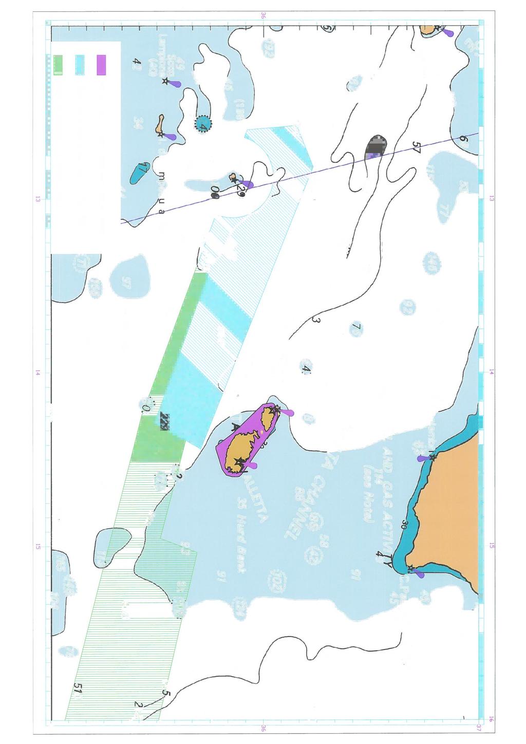
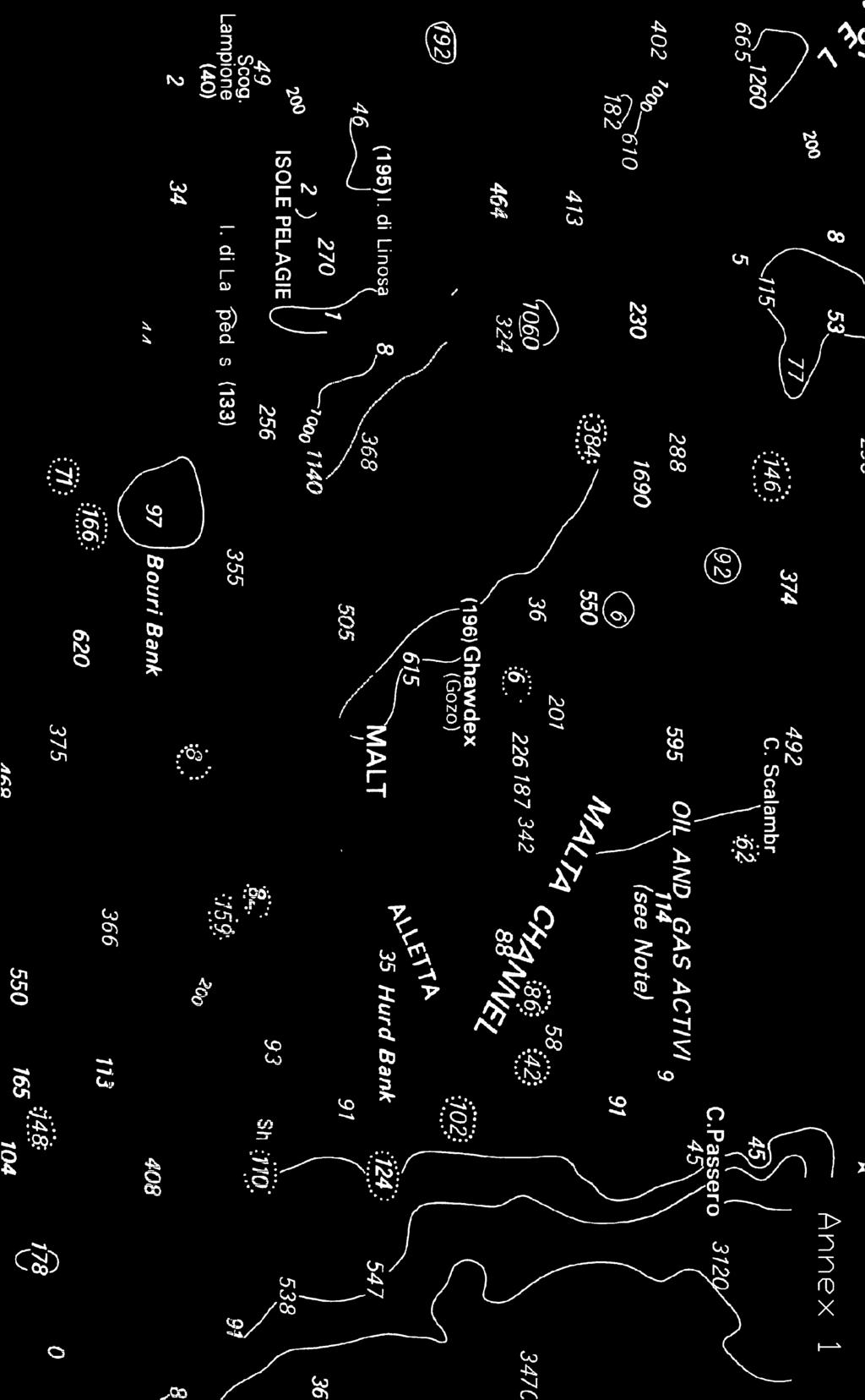
2 Item 1 Hydrographic Office Transport Malta is responsible for all transport and maritime sectors. The Hydrographic Office forms part of the Ports and Yachting Directorate under the Marine Department. The Chief Officer, Capt David Bugeja is responsible for this Directorate. The Hydrographic Office is responsible for safety to navigation incorporating updates of navigational charts, navigational aids, notices to mariners and navigational warnings. Transport Malta head office is located at the Malta Transport Centre Ports and Yachting Directorate Malta Transport Centre Xatt l-ghassara ta l-gheneb, Marsa HMR 1917 Malta Item 2 Surveys The Hydrographic Office is equipped with a 15m survey boat to survey the ports and harbours. The Hydrographic Office is with a single beam echo sounder ELAC HYDROSTAR and GPS Trimble DSM 12 for positioning. These are portable and so can be mounted on a smaller boat so as to survey very shallow areas. 2.1) Regular surveys have been carried out in ports and harbours to maintain British Admiralty Charts. 2.2) A LIDAR and multibeam survey around the Maltese Islands has been carried out between June 2012 and August An area of 1 Nautical Mile offset from the baseline was covered. The LIDAR survey covered the area up to the 15m contour however since the water was very clear most of the survey covered up to 40m depth. All this data is now being evaluated. 2.3) Through a bilateral agreement with the French Hydrographic Office (SHOM) two areas (north west to west of Malta and West to south - southeast of Malta) were surveyed with multibeam by the SHOM survey vessel Laperouse.(See annex 1). Item 3 New Charts and Updates Through the EUMEDIS, MEDChartNet project the hydrographic office was supplied with 11 ENCs. These charts are being used by our VTS. The Hydrographic office is maintaining these charts but they have not been released for distribution. Through a bilateral agreement the UKHO at present produce the Maltese paper charts. This year 2 Charts have been updated that is BA 177 and BA 211. T There is also an agreement for the production of ENC s of the Maltese waters. The UKHO produce 6 ENCs corresponding to paper charts BA 194, BA 2537, and 2538, BA 177, BA 211 and BA 36 Thus having all the ENCs required to navigate in the Maltese Waters. 2
3 Item 4 Publications There are no Maltese publications but information is sent to the UKHO where the Mediterranean Pilot Sailing Directions NP 45, List of Lights and fog signals NP 78, Admiralty list of Radio Signals NP 286(3) and Maritime Communications NP 289, are being updated with the latest Maltese information. Notices to mariners are issued as they come in. These are promulgated through the Maltese Government Gazette. Notices to Mariners and Navigational warnings are sent to NavArea 3 Coordinator (Spain), Italy, Russia and the UKHO. Item 5 NAVTEX MSI This service is operated by the military service (Armed Forces of Malta) that is also responsible for the search and rescue operations. The NAVTEX area has been modified as per chart attached (Annex 2): GMDSS Item 6 Master Plan has been implemented and is operational in A1 and A2. A fully compliant coast radio system has been incorporated into the new existing VTS. This includes a NAVTEX transmitter with a complete re-location of all transmitters and antennae. S-55 Latest Update no update Item 7 Capacity Building - None Item 8 Oceanographic Activities Tide Gauge Network A digital tide gauge records sea level data. This data is transmitted to the office by VHF in real time. This data is forwarded to the PMSL laboratory and to the UKHO. An old mechanical tide gauge has been installed in the south port, which is 8 Nautical Miles away. The same datum was transferred to this port. No tide difference was observed during the years of operation. The Physical Oceanography Unit (PO-Unit) This is an independent research unit at the University of Malta Projects CALYPSO CALYPSO is a 2-year project partly financed by the EU under the Operational Programme Italia-Malta , and co-ordinated by Prof. Aldo Drago from the Physical Oceanography Unit of the University of Malta. It brings together 3 other partners from Malta namely Transport Malta, Civil Protection Department and Armed Forces of Malta and 4 partners from Sicily ARPA Sicilia, IAMC- CNR Capo Granitola, Università degli Studi di Palermo (UNIPA) and Università di Catania (CUTGANA). The consortium consists of research entities and also public entities with responsibilities for civil and environmental protection, surveillance, security and response to hazards. 3
4 The main project deliverable is the setting up of a permanent and fully operational HF radar observing system, capable of recording (in real-time with hourly updates) surface currents in the Malta Channel. The system consists of HF radar installations on the northern Malta and southern Sicilian shores at selected sites and combines stations to elaborate and publish data to users. Collected data, combined to numerical models, are intended to primarily support applications to optimise intervention in case of oil spill response as well as endow tools for search and rescue, security, safer navigation, improved metro-marine forecasts, monitoring of sea conditions in critical areas such as proximity to ports, and better management of the marine space between Malta and Sicily. Project website can be found here. Mediterranean Decision Support System for Marine Safety (MEDESS-4MS) Mediterranean Decision Support System for Marine Safety (MEDESS-4MS) is dedicated to the strengthening of maritime safety by mitigating the risks and impacts associated to oil spills. MEDESS-4MS capitalizes on existing pan- European frameworks and embraces recent advances and important developments in oceanography in the Mediterranean area. MEDESS-4MS aims to deliver an integrated operational multi model oil spill system in the Mediterranean by gathering and analyzing met-ocean data as well as data related to ship traffic, ship operations and sensitivity mapping. This data will be provided to well established oil spill monitoring and forecasting systems, thus, providing an invaluable tool regarding the early detection and efficient control of the oil spill at early stages. Therefore, MEDESS-4MS aims to offer a comprehensive and integrated multimodel approach regarding our response to oil spills at sea; an approach that takes into account all three important aspects related to marine pollution, that is, Prevention, Detection and Control. The beneficiary countries of MEDESS-4MS are Cyprus, France, Greece, Italy, Malta, Montenegro and Spain. Project website can be found here. BLUE OCEAN ENERGY The BLUE OCEAN ENERGY (BOE) project aims to adapt and test the feasibility of the DEXAWAVE converter as a means of extracting energy from sea waves in the Maltese coastal sea areas. The converter is based on a technology developed by Dexawave Energy ApS and promises to be an innovative, simple, cost-effective and competitive source of electrical power. The PO-Unit will be utilising its experience and expertise in wave modelling and analysis. It will be using high resolution wave models and data to define a wave climatology around the Maltese Islands. The analysis of such a climatology will serve as a basis to identify and map the wave energy resource. The PO-Unit will be also monitoring and analysing the wave conditions at the location of the converter. 4
5 Project website can be found here. SeaDataNet SeaDataNet is an EU-funded FP6 project targeting to develop an efficient pan- European infrastructure for ocean and marine data management. The predecessor of SeaDataNet, the Sea-Search project, led to the development of databases which store meta-data marine records held by European organisations, information about marine projects within Europe, and reports about research cruises organised by European institutions. These databases can be found here. In SeaDataNet these databases are being continued, updated and harmonised. The main objective of SeaDataNet is to construct a standardized system for managing the large and diverse data sets collected by the oceanographic fleets and the new automatic observation systems. The objective is to network and enhance the currently existing infrastructures, which are the national oceanographic data centres and satellite data centres of 35 countries, active in data collection. The networking of these professional data centres, in a unique virtual data management system will provide integrated integrated data sets of standardized quality on-line. The PO-Unit is responsible for the archival and management of oceanographic data relating to the Maltese Islands. In SeaDataNet, IOI-MOC forms part of this European virtual ocean data system, and will continue to maintain the local oceanographic databases, and update their structure to make them compatible with the central databases. These local databases can be currently accessed online through the Malta Blue Pages. SeaDataNet is also preparing added-value products developed from data in the European regional seas. IOI-MOC will assist in the development of such user products for the Mediterranean region. More information about SeaDataNet can be found here. MyOcean MyOcean is a European Network to monitor, analyse and forecast the Oceans. Its main objective is the implementation of the GMES (Global Monitoring for the Environment & Security) Marine Core Service, whose aim it is to deploy the first concerted and integrated pan-european capacity for Ocean Monitoring and Forecasting. By virtue of its track record in operational oceanography, and its involvement in European research networks, the PO-Unit is engaged as the Maltese partner in MyOcean. Its main role in the project is to act as a local broker to promote the application of the MyOcean Marine Core Service (MCS) to the benefit of Maltese users, as well as to make use and transform marine regional scale data into added value products and services at the local scale. 5
6 The PO-Unit is directly involved in the project implementation in relation to Calibration/Validation and Quality evaluation of Mediterranean Monitoring and Forecasting Systems, as well as in the assessment of MyOcean products and services to provide/update requirements for Maltese local users in the main areas of benefit identified by the MCS. More information about the MyOcean project can be found here. Item 9 Other activities (a) Monitoring dredging operations in the development of a Freeport Harbour and around Malta. (b) Assisting the Harbour Master in decision making for the berthing of vessels and safe passage in Ports and Harbours. c) Monitoring Navigational Aids and issue Notices to Mariners and Navigational warnings. d) Provide charts in connection with mooring areas in the Maltese coastal waters. Item 10 Conclusions The Maltese Hydrographic Office now comprises of two qualified Hydrographic surveyors and another officer has been enrolled to cover Electronic Charting. In its limited functions, it is able to maintain the Maltese Navigation Charts and contributes highly to safety of navigation in Maltese waters by issuing Notices to Mariners and Navigational Warnings. 6


7
![Annex 2 Trieste [U] Mondolfo [U] FRANCE (La Garde) [W] Roma [R] La Maddalena [R] Cagliari [T] Augusta [V] Sellia Marina [V] TUNISIA (Kelibia) [T] MALTA [O] [T]](/docs-images/74/70384752/images/8-0.jpg "[O] [S] New Italian stations Old Italian station Other stations KEY La Maddalena Sellia Marina Service Area MALTA TUNISIA (Kelibia) Mondolfo FRANCE (La Garde)")
8 Annex 2 Trieste [U] Mondolfo [U] FRANCE (La Garde) [W] Roma [R] La Maddalena [R] Cagliari [T] Augusta [V] Sellia Marina [V] TUNISIA (Kelibia) [T] MALTA [O] [T] [O] [S] New Italian stations Old Italian station Other stations KEY La Maddalena Sellia Marina Service Area MALTA TUNISIA (Kelibia) Mondolfo FRANCE (La Garde) 7
WWNWS3/3/3/1A Meeting 3 1 August 2011 Agenda Item NAVTEX Panel Report SUMMARY
 WWNWS WWNWS3/3/3/1A Meeting 3 1 August 2011 Agenda Item 3.3.1 NAVTEX Panel Report Submitted by Chair, IMO International NAVTEX Co-ordinating Panel SUMMARY Executive Summary: This report provides a summary
Myanmar Naval Hydrographic Centre. National Report for 13 th North Indian Ocean Hydrographic Commission Meeting
 Myanmar Naval Hydrographic Centre National Report for 13 th North Indian Ocean Hydrographic Commission Meeting Yangon, Myanmar 19 th 22 nd February 2013 CONTENT 1. Myanmar Naval Hydrographic Centre 2.
UNITED KINGDOM NATIONAL REPORT
 SAIHC12-5.3K UNITED KINGDOM NATIONAL REPORT 12 TH SOUTHERN AFRICA AND ISLANDS HYDROGRAPHIC COMMISSION (SAIHC) MEETING Dar es Salaam, Tanzania 22 nd 23 rd September 2015 This report supplements the UK Generic
EGYPTIAN HYDROGRAPHIC DEPARTMENT THE EGYPTIAN HYDROGRAPHIC FRAMEWORK
 gvt THE EGYPTIAN HYDROGRAPHIC FRAMEWORK The roles of a national Hydrographic Service can be summarized in collecting georeferenced data through systematic surveys at sea and along the coast related to:
LT Matthew Forney, NOAA Navigation Manager Alaska Region Bering Strait MaritimeSymposium. Office of Coast Survey
 NOAA LT Matthew Forney, NOAA Navigation Manager Alaska Region Bering Strait MaritimeSymposium Who is Coast Survey? First science agency of the U.S. Formed in 1807 Responsible for surveying 3.4 million
e-navigation Progress and trends: the IHO perspective
 International Hydrographic Organization e-navigation Progress and trends: the IHO perspective Gilles Bessero Director, IHO International Hydrographic Organization Intergovernmental consultative and technical
The ship RV Timba repairs are now almost complete and it is expected that come September 2014 the ship will be fully operational.
 Malawi National Report 2014 1 Malawi Hydrographic Office The assembly of the 70 ton ship RV Timba with the assistance of the French government in 1989 ushered in the commencement of modern hydrographic
MARITIME SAFETY INFORMATION
 Introduction 1. Maritime Safety Information (MSI) is defined as navigational and meteorological warnings, meteorological forecasts, and other urgent safety-related messages. This information is of vital
AN OVERVIEW OF THE STATE OF MARINE SPATIAL PLANNING IN THE MEDITERRANEAN COUNTRIES MALTA REPORT
 AN OVERVIEW OF THE STATE OF MARINE SPATIAL PLANNING IN THE MEDITERRANEAN COUNTRIES MALTA REPORT Malta Environment & Planning Authority May 2007 AN OVERVIEW OF THE STATE OF MARINE SPATIAL PLANNING IN THE
Maritime Administration of Latvia Hydrographic Service National Report to Baltic Sea Hydrographic Commission
 Maritime Administration of Latvia Hydrographic Service National Report to Baltic Sea Hydrographic Commission Executive summary 2017 The Report gives an overview of the main activities of Hydrographic Service
DEVELOPMENT OF A DEFINITION FOR MSPS AND CONSIDERATION FOR THE HARMONIZATION OF THE FORMAT AND STRUCTURE OF MSPS
 INTERNATIONAL HYDROGRAPHIC ORGANIZATION E IMO/IHO HARMONIZATION GROUP ON DATA MODELLING Agenda item 5 15 September 2017 ENGLISH ONLY DEVELOPMENT OF A DEFINITION FOR MSPS AND CONSIDERATION FOR THE HARMONIZATION
TECHNICAL COMMITTEE 80: MARITIME NAVIGATION AND RADIOCOMMUNICATION EQUIPMENT AND SYSTEMS INTERNATIONAL ELECTROTECHNICAL COMMISSION
 TECHNICAL COMMITTEE 80: MARITIME NAVIGATION AND RADIOCOMMUNICATION EQUIPMENT AND SYSTEMS INTERNATIONAL ELECTROTECHNICAL COMMISSION IEC TECHNICAL COMMITTEE 80: MARITIME NAVIGATION AND RADIOCOMMUNICATION
There is also need to acquire equipment such as GPS, Echo-Sounder and update data acquisition and processing software among other requirements.
 Malawi National Report 2016 1 Malawi Hydrographic Office The mandate of the Hydrographic office is to carry out surveys of Lake Malawi including the lesser lakes of Malombe, Chilwa and Chiuta as well as
GMDSS communication systems
 GMDSS Basic Concepts A System Overview Functional requirements The GMDSS (Global Maritime Distress and Safety System) is specifically designed to automate a ship's radio distress alerting function, and,
The BLUEMED Initiative: RESEARCH AND INNOVATION INITIATIVE FOR BLUE JOBS AND GROWTH IN THE MEDITERRANEAN
 Maritime Spatial Planning in the, an occasion for Blue Growth Rome, 27 th February 2017 The BLUEMED Initiative: RESEARCH AND INNOVATION INITIATIVE FOR BLUE JOBS AND GROWTH IN THE MEDITERRANEAN Enrico Brugnoli,
MESOAMERICAN AND CARIBBEAN HYDROGRAPHIC COMMISSION 11 th Meeting, Paramaribo, Suriname, Novembro NATIONAL REPORT BRAZIL
 Page 1 of 5 MESOAMERICAN AND CARIBBEAN HYDROGRAPHIC COMMISSION 11 th Meeting, Paramaribo, Suriname, Novembro 8-12 2010 NATIONAL REPORT BRAZIL 1. Hydrographic Office / Service: Directorate of Hydrography
Maritime Administration of Latvia (MAL) Hydrographic Service National Report to Baltic Sea Hydrographic Commission
 Hydrographic Service National Report to Baltic Sea Hydrographic Commission") Maritime Administration of Latvia (MAL) Hydrographic Service National Report to Baltic Sea Hydrographic Commission Executive summary 2016 The Report gives an overview of the main activities of Hydrographic
Maritime Administration of Latvia (MAL) Hydrographic Service National Report to Baltic Sea Hydrographic Commission Executive summary 2016 The Report gives an overview of the main activities of Hydrographic
IMO/IHO World-wide Navigational Warning Service (WWNWS)
") IMO/IHO World-wide Navigational Warning Service (WWNWS) 1 WWNWS 1972 PROPOSAL TO SET UP AN Ad Hoc IHO/IMO COMMITTEE TO DEVELOP AN INTER- NATIONALLY CO-ORDINATED SYSTEM FOR PROMULGATING LONG RANGE NAVIGATIONAL
IMO/IHO World-wide Navigational Warning Service (WWNWS) 1 WWNWS 1972 PROPOSAL TO SET UP AN Ad Hoc IHO/IMO COMMITTEE TO DEVELOP AN INTER- NATIONALLY CO-ORDINATED SYSTEM FOR PROMULGATING LONG RANGE NAVIGATIONAL
Digital broadcasting systems under development within ITU-R of interest for the maritime community
 Digital broadcasting systems under development within ITU-R of interest for the maritime community Christian RISSONE ANFR rissone@anfr.fr IHO, WWNWS 5 Monaco, 2 nd October 2013 1 Background for the 500
The Italian RITMARE network of coastal radars
 The Italian RITMARE network of coastal radars Coordinator: Annalisa Griffa (ISMAR CNR) Participants: Carlo Mantovani, Lorenzo Corgnati (ISMAR CNR) Francesco Serafino (IREA CNR) Simone Cosoli (OGS) Francesco
UNITED KINGDOM NATIONAL REPORT
 Page 1 of 9 UNITED KINGDOM NATIONAL REPORT TO THE 11 th MEETING OF THE MESO AMERICAN AND CARIBBEAN SEA HYDROGRAPHIC COMMISSION Paramaribo, Suriname 8 th 12 th November 2010 NOTE: This report supplements
Demonstrator of a Data Processing Centre (DPC) for satellite-based AIS services
 for satellite-based AIS services") Page 1 Demonstrator of a Data Processing Centre (DPC) for satellite-based AIS services 19/20 April 2012 gfabritius@cls.fr Overview of the presentation Page 2 Introducing CLS Introducing AIS / SAT-AIS Scope
Page 1 Demonstrator of a Data Processing Centre (DPC) for satellite-based AIS services 19/20 April 2012 gfabritius@cls.fr Overview of the presentation Page 2 Introducing CLS Introducing AIS / SAT-AIS Scope
AMENDMENTS TO RESOLUTION A.705(17) PROMULGATION OF MARITIME SAFETY INFORMATION
 PROMULGATION OF MARITIME SAFETY INFORMATION") E 4 ALBERT EMBANKMENT LONDON SE1 7SR Telephone: +44 (0)20 7735 7611 Fax: +44 (0)20 7587 3210 AMENDMENTS TO RESOLUTION A.705(17) PROMULGATION OF MARITIME SAFETY INFORMATION MSC.1/Circ.1287/Rev.1 24 June
E 4 ALBERT EMBANKMENT LONDON SE1 7SR Telephone: +44 (0)20 7735 7611 Fax: +44 (0)20 7587 3210 AMENDMENTS TO RESOLUTION A.705(17) PROMULGATION OF MARITIME SAFETY INFORMATION MSC.1/Circ.1287/Rev.1 24 June
RESOLUTION MSC.278(85) (adopted on 1 December 2008) ADOPTION OF THE NEW MANDATORY SHIP REPORTING SYSTEM "OFF THE COAST OF PORTUGAL - COPREP"
 (adopted on 1 December 2008) ADOPTION OF THE NEW MANDATORY SHIP REPORTING SYSTEM OFF THE COAST OF PORTUGAL - COPREP") MSC 85/26/Add.1 RESOLUTION MSC.278(85) SYSTEM OFF THE COAST OF PORTUGAL COPREP THE MARITIME SAFETY COMMITTEE, RECALLING Article 28 of the Convention on the International Maritime Organization concerning
MSC 85/26/Add.1 RESOLUTION MSC.278(85) SYSTEM OFF THE COAST OF PORTUGAL COPREP THE MARITIME SAFETY COMMITTEE, RECALLING Article 28 of the Convention on the International Maritime Organization concerning
SPAIN NATIONAL REPORT/ ეროვნული ანგარიში.
 SPAIN NATIONAL REPORT/ ეროვნული ანგარიში http://www.armada.mde.es/ihm. 2 Index 1. Hydrographic Offices 2. Surveys 3. Charts and updates 4. Publications and updates 5. MSI 6. C-55 7. Capacity Building 8.
Draft submission paper: Hydrographic Offices way on EMODnet. Subject : Hydrographic Offices way on EMODnet. Foreword :
 Subject : Hydrographic Offices way on EMODnet Foreword : This paper is aimed to present the state of the EMODnet project, the European Commission s policy for this project, the principles of the Hydrographic
National Report of Finland
 National Report of Finland [31 August 2010] Executive Summary This Report gives an overview of the main activities of the Finnish Hydrographic Office (FHO) since the previous BSHC 14 th Conference. The
ROUTEING OF SHIPS, SHIP REPORTING AND RELATED MATTERS. New traffic separation schemes and two-way routes in Norra Kvarken
 E SUB-COMMITTEE ON SAFETY OF NAVIGATION 57th session Agenda item 3 NAV 57/3/7 11 March 2011 Original: ENGLISH ROUTEING OF SHIPS, SHIP REPORTING AND RELATED MATTERS New traffic separation schemes and two-way
European Maritime Day 2019, Burgas, Bulgaria. 31 May & 1 June. List of exhibitors
 European Maritime Day 2019, Burgas, Bulgaria 31 May & 1 June List of exhibitors 1 Name Description Logo ACTeon We will present H2020 project on ocean literacy - Responseable and different ocean literacy
UNITED KINGDOM NATIONAL REPORT
 UNITED KINGDOM NATIONAL REPORT TO THE 10 TH MACHC HYDROGRAPHIC COMMISSION MEETING Barbados 4 5 th November 2009 This report supplements the UK Generic National Report 2009, posted on the UKHO website (www.ukho.gov.uk),
ROUTEING OF SHIPS, SHIP REPORTING AND RELATED MATTERS. Establishment of a Mandatory Ship Reporting System in the
 INTERNATIONAL MARITIME ORGANIZATION E SUB-COMMITTEE ON SAFETY OF NAVIGATION 48th session Agenda item 3 IMO NAV 48/3/2 11 April 2002 Original: ENGLISH ROUTEING OF SHIPS, SHIP REPORTING AND RELATED MATTERS
WWNWS10/2/1-I Meeting July 2018 Agenda Item 2.I. MSI Self Assessment NAVAREA I. Submitted by United Kingdom SUMMARY
 WWNWS WWNWS10/2/1-I Meeting 10 19 July 2018 Agenda Item 2.I MSI Self Assessment NAVAREA I Submitted by United Kingdom SUMMARY Executive Summary: Overview of activities undertaken within NAVAREA I since
CAPACITY BUILDING PLAN Programme document for the period
 INTERNATIONAL HYDROGRAPHIC ORGANIZATION MESO AMERICAN & CARIBBEAN SEA HYDROGRAPHIC COMMISSION 1. INTRODUCTION CAPACITY BUILDING PLAN Programme document for the period 2013-2017 1.1. Rationale It is estimated
PROGRESS UPDATE AND FUTURE DIRECTIONS OF THE MARINE ELECTRONIC HIGHWAY (MEH)
") PROGRESS UPDATE AND FUTURE DIRECTIONS OF THE MARINE ELECTRONIC HIGHWAY (MEH) BACKGROUND 1. The Marine Electronic Highway Demonstration Project (MEH DP) was a 4- year regional project in the Straits of
PROGRESS UPDATE AND FUTURE DIRECTIONS OF THE MARINE ELECTRONIC HIGHWAY (MEH) BACKGROUND 1. The Marine Electronic Highway Demonstration Project (MEH DP) was a 4- year regional project in the Straits of
JCG GMDSS Symposium NAVDAT : Navigational Data
 JCG GMDSS Symposium 2013 NAVDAT : Navigational Data - System Presentation - Pascal OLIVIER NAVDAT Presentation Page 1/35 From analog to digital in maritime radio communications The current analog radio
DRAFT ASSEMBLY RESOLUTION A. (26)
") DRAFT ASSEMBLY RESOLUTION A. (26) PROMULGATION OF MARITIME SAFETY INFORMATION The ASSEMBLY, RECALLING Article 15(j) of the Convention on the International Maritime Organization concerning the functions
DRAFT ASSEMBLY RESOLUTION A. (26) PROMULGATION OF MARITIME SAFETY INFORMATION The ASSEMBLY, RECALLING Article 15(j) of the Convention on the International Maritime Organization concerning the functions
NEW ZEALAND NOTICES TO MARINERS
 NEW ZEALAND NOTICES TO MARINERS Notices NZ 147-148 Published fortnightly by the New Zealand Hydrographic Authority Crown Copyright 2018. All rights reserved. Permission is not required to make analogue
Satellite services for maritime security
 Satellite services for ITS-T Sophia Antipolis 6 June 2007 Jean-Pierre Cauzac, CLS - Collecte Localisation Satellites 35 Are the seas becoming more dangerous? IMB report 2006 shows improvement: 239 piracy
Stay connected. at sea
 Stay connected at sea 4G system for internet access in coastal areas NeptuLink FAQs by MVG How does it work? Through its two antenna transmitter-receivers NeptuLink by MVG serves as a terminal that connects
Future of Sustained Observations
 Future of Sustained Observations OceanObs 09 identified tremendous opportunities, significant challenges Called for a framework for planning and moving forward with an enhanced global sustained ocean observing
NEW ZEALAND NOTICES TO MARINERS
 NEW ZEALAND NOTICES TO MARINERS Notice NZ 133 133 Published fortnightly by the New Zealand Hydrographic Authority Crown Copyright 2018. All rights reserved. Permission is not required to make analogue
ESA IAP Blue Belt demonstration project:
 Page 1 ESA IAP Blue Belt demonstration project: supporting the European Maritime Safety Agency (EMSA) Blue Belt Project, by providing a service based on satellite based AIS data complementing the terrestrial
NAVIGA TIONAL VIGA WARNINGS/MSI/GMDSS N NAV NA AREA III VIII
 NAVIGATIONAL WARNINGS/MSI/GMDSS IN NAVAREA VIII 5/16/2008 1 SCOPE OF PRESENTATION 1. Introduction 2. Navarea VIII Radio Warnings 3. Indian Notices to Mariners 4. Implementation of GMDSS 5. Marine Safety
WWNWS9/3/2/XVII_XVIII Meeting 9 21 July 2017 Agenda Item 3.2. MSI Self Assessment NAVAREA XVII_XVIII. Submitted by Canada (Canadian Coast Guard)
") WWNWS WWNWS9/3/2/XVII_XVIII Meeting 9 21 July 2017 Agenda Item 3.2 MSI Self Assessment NAVAREA XVII_XVIII Submitted by Canada (Canadian Coast Guard) SUMMARY Executive Summary: Summary of activities within
WWNWS WWNWS9/3/2/XVII_XVIII Meeting 9 21 July 2017 Agenda Item 3.2 MSI Self Assessment NAVAREA XVII_XVIII Submitted by Canada (Canadian Coast Guard) SUMMARY Executive Summary: Summary of activities within
Paper for Consideration by SNPWG. [Radio Services Product Specification Sample data sets]
![Paper for Consideration by SNPWG. [Radio Services Product Specification Sample data sets]](/thumbs/72/67892905.jpg "Paper for Consideration by SNPWG. [Radio Services Product Specification Sample data sets]") SNPWG 17-9 Paper for Consideration by SNPWG [Radio Services Product Specification Sample data sets] Submitted by: Executive Summary: Related Documents: Related Projects: FRANCE The Jusslandian List of
SNPWG 17-9 Paper for Consideration by SNPWG [Radio Services Product Specification Sample data sets] Submitted by: Executive Summary: Related Documents: Related Projects: FRANCE The Jusslandian List of
Meeting 10 8 August 2018 Agenda Item 2.1. MSI Self Assessment NAVAREA XVI. Submitted by PERÚ - DIRECTORATE OF HYDROGRAPHY AND NAVIGATION SUMMARY
 WWNWS10 WWNWS10/2/1-XVI Meeting 10 8 August 2018 Agenda Item 2.1 MSI Self Assessment NAVAREA XVI Submitted by PERÚ - DIRECTORATE OF HYDROGRAPHY AND NAVIGATION SUMMARY Executive Summary: Report of activities
Western Mediterranean Forum (Euro Mediterranean Dialogue 5+5)
") Western Mediterranean Forum (Euro Mediterranean Dialogue 5+5) RESEARCH, INNOVATION AND HIGHER EDUCATION BLUEMED Initiative Dialogue 5+5 PRIMA Initiative EUSAIR The BLUEMED initiative The BLUEMED Initiative
Western Mediterranean Forum (Euro Mediterranean Dialogue 5+5) RESEARCH, INNOVATION AND HIGHER EDUCATION BLUEMED Initiative Dialogue 5+5 PRIMA Initiative EUSAIR The BLUEMED initiative The BLUEMED Initiative
GLMTF November 18, 2014 Presentation
 GLMTF November 18, 2014 Presentation Michigan Security Network Founded by major corporations, industry leaders and leading universities in 2008 as a non-profit organization (501c6). MiSN mission is to
FRENCH NATIONAL REPORT TO THE 6 TH MEETING OF THE ROPME HYDROGRAPHIC COMMISSION
 Paris, January, 30th 2015 SERVICE HYDROGRAPHIQUE ET OCEANOGRAPHIQUE DE LA MARINE N 003 SHOM/DMI/REX/NP DIRECTION DES MISSIONS INSTITUTIONNELLES ET DES RELATIONS INTERNATIONALES Dossier suivi par IPETA
PAPUA NEW GUINEA HYDROGRAPHIC SERVICE
 PAPUA NEW GUINEA HYDROGRAPHIC SERVICE IHO SOUTH WEST PACIFIC HYDROGRAPHIC COMMISSION (SWPHC) 9 th Meeting Port Moresby, Papua New Guinea, 10-11 March 2007 SWPHC9-01PNG 1. INTRODUCTION 9 th SOUTH WEST PACIFIC
RESOLUTION MSC.229(82) (adopted on 5 December 2006) ADOPTION OF A NEW MANDATORY SHIP REPORTING SYSTEM "IN THE GALAPAGOS PARTICULARLY SENSITIVE SEA
 (adopted on 5 December 2006) ADOPTION OF A NEW MANDATORY SHIP REPORTING SYSTEM IN THE GALAPAGOS PARTICULARLY SENSITIVE SEA") MSC 82/24/Add.2 RESOLUTION MSC.229(82) IN THE GALAPAGOS PARTICULARLY SENSITIVE SEA AREA (PSSA) (GALREP) THE MARITIME SAFETY COMMITTEE, RECALLING Article 28(b) of the Convention on the International Maritime
MSC 82/24/Add.2 RESOLUTION MSC.229(82) IN THE GALAPAGOS PARTICULARLY SENSITIVE SEA AREA (PSSA) (GALREP) THE MARITIME SAFETY COMMITTEE, RECALLING Article 28(b) of the Convention on the International Maritime
There has been some success
 Surveying Hydrography in Africa by Captain Abri Kampfer, Hydrographer SA Navy The International Hydrographic Bureau (IHB) and many member states of the International Hydrographic Organisation (IHO) have
Arctic Shipping Navigating the Legal Landscape for marine infrastructure and Off-Shore Development
 Arctic Shipping Navigating the Legal Landscape for marine infrastructure and Off-Shore Development Peter G. Pamel Partner Connecticut Maritime Association SHIPPING 2012 Hilton Stamford March 21 st, 2012
AMENDMENTS TO RESOLUTION A.706(17) WORLD-WIDE NAVIGATIONAL WARNING SERVICE
 WORLD-WIDE NAVIGATIONAL WARNING SERVICE") E 4 ALBERT EMBANKMENT LONDON SE1 7SR Telephone: +44 (0)20 7735 7611 Fax: +44 (0)20 7587 3210 AMENDMENTS TO RESOLUTION A.706(17) WORLD-WIDE NAVIGATIONAL WARNING SERVICE MSC.1/Circ.1288/Rev.1 24 June 2013
E 4 ALBERT EMBANKMENT LONDON SE1 7SR Telephone: +44 (0)20 7735 7611 Fax: +44 (0)20 7587 3210 AMENDMENTS TO RESOLUTION A.706(17) WORLD-WIDE NAVIGATIONAL WARNING SERVICE MSC.1/Circ.1288/Rev.1 24 June 2013
NEW ZEALAND CHARTING AND NOTICES TO MARINERS
 General Information 1. In accordance with agreements between New Zealand, Australia (AUS) and the British Admiralty (BA) for reducing duplication in charting activities, New Zealand has a defined Charting
COMMUNICATIONS FOR MARITIME SAFETY AND EFFICIENCY. Francis Zachariae, Secretary-General, IALA
 COMMUNICATIONS FOR MARITIME SAFETY AND EFFICIENCY Francis Zachariae, Secretary-General, IALA IALA and its Purpose Non profit, international technical association established in 1957 Two Goals aimed at
APPLICATIONS OF KINEMATIC GPS AT SHOM
 International Hydrographic Review, Monaco, LXXVI(1), March 1999 APPLICATIONS OF KINEMATIC GPS AT SHOM by Michel EVEN 1 Abstract The GPS in kinematic mode has now been in use at SHOM for several years in
dkart Navigator 9010
 dkart Navigator 9010 dkart Navigator - purpose dkart Navigator is an electronic navigation chart system specially designed to facilitate all the navigational tasks of mariner's day-to-day practice. Along
ECDIS ENC Accuracy. Contents. Introduction LOSS PREVENTION BRIEFING FOR NORTH MEMBER SHIPS / MAY Introduction... 1
 LOSS PREVENTION BRIEFING FOR NORTH MEMBER SHIPS / MAY 2017 ECDIS ENC Accuracy Contents Introduction... 1 ECDIS Specific Familiarisation... 2 IHO S-57... 2 ENC Data Source... 2 CATZOC and M_QUAL... 2 CATZOC
European Commission Workshop «SATELLITE IMAGERY AND ILLEGAL OIL SPILLS IN EUROPE AND IN THE MEDITERRANEAN» Round table 1 : «DETECTION TECHNIQUES»
 European Commission Workshop «SATELLITE IMAGERY AND ILLEGAL OIL SPILLS IN EUROPE AND IN THE MEDITERRANEAN» Round table 1 : «DETECTION TECHNIQUES» Round table 2 : «MUTUAL INFORMATION AND PROSECUTION PROCEDURES»
Maritime Communications
 Maritime Communications Strategic Sectorial Spectrum Needs Conferência sobre Gestão do Espectro: Perspectivas, Desafios e Estratégias Lisboa, 20 de setembro de 2013 RSPG Work Programme 2012 and Beyond
Recent Developments in NOAA s Real- Time Coastal Observing Systems for Safe and Efficient Maritime Transportation
 Recent Developments in NOAA s Real- Time Coastal Observing Systems for Safe and Efficient Maritime Transportation Rich Edwing, Director NOAA Center for Operational Oceanographic Products and Services CMTS
BookletChart. Sacramento River Andrus Island to Sacramento NOAA Chart A reduced-scale NOAA nautical chart for small boaters
 BookletChart Sacramento River Andrus Island to Sacramento NOAA Chart 18662 A reduced-scale NOAA nautical chart for small boaters When possible, use the full-size NOAA chart for navigation. Included Area
CPRNW. WWNWS9/3/3/3.2 Meeting 9 20 July 2017 Agenda Item Joint MET/NAVAREA XVII and XVIII Client Survey
 CPRNW WWNWS WWNWS9/3/3/3.2 Meeting 9 20 July 2017 Agenda Item 3.3.3.2 Joint MET/NAVAREA XVII and XVIII Client Survey Submitted by Canada, NAVAREA XVII_XVIII SUMMARY Executive Summary: This document describes
The human touch in technology. ECDIS ECS Conning screen Ship speed info system
 The human touch in technology ECDIS ECS Conning screen Ship speed info system Alphatron ALPHACHART T ECDIS Type approved ECDIS system powered by TRANSAS The ALPHACHART T is an advanced Electronic Chart
OPERATIONS SEAFARER CERTIFICATION GUIDANCE NOTE SA MARITIME QUALIFICATIONS CODE SHORT RANGE CERTIFICATE (SRC)
") Page 1 of 8 Compiled by Chief Examiner Approved by Senior Radio Examiner OPERATIONS SEAFARER CERTIFICATION GUIDANCE NOTE SA MARITIME QUALIFICATIONS CODE SHORT Page 2 of 8 SHORT : OUTLINE EXAMINATION SYLLABUS
Page 1 of 8 Compiled by Chief Examiner Approved by Senior Radio Examiner OPERATIONS SEAFARER CERTIFICATION GUIDANCE NOTE SA MARITIME QUALIFICATIONS CODE SHORT Page 2 of 8 SHORT : OUTLINE EXAMINATION SYLLABUS
Integration of AIS functionalities
 Integration of AIS functionalities by John O. Klepsvik FARGIS 05 March 01, 2005 WORLD CLASS through people, technology and dedication WORLD CLASS through people, technology and dedication KONGSBERG March
About BALTICO. Contact The BALTICO-office could be contacted as follows:
 1 (5) Operations Administrator, Telephone Svante Håkansson, +46 11 19 10 07 Your date erence Your reference BALTICO MEETING 2004 About BALTICO Tasks The BALTICO-office at the Swedish Maritime Administration
Benefits analysis. Benefit categorisation. Lesley Murphy QinetiQ. ESA Space Weather Programme study Final presentation, 6th-7th December 2001
 Benefits analysis Lesley Murphy QinetiQ ESA Space Weather Programme study Final presentation, 6th-7th December 2001 Benefit categorisation STRATEGIC - affecting Europe s industrial, military, technological
MBSHC (Mediterranean and Black Seas Hydrographic Commission) XVII. conference, Greece Jun. 2011
 XVII. conference, Greece Jun. 2011") MBSHC (Mediterranean and Black Seas Hydrographic Commission) XVII. conference, Greece 01. 03. Jun. 2011 National report of SLOVENIA 01. May 2011 MBSHC report - SLOVENIA 1 0 Index 0 Index... 2 1 Hydrographic
MBSHC (Mediterranean and Black Seas Hydrographic Commission) XVII. conference, Greece 01. 03. Jun. 2011 National report of SLOVENIA 01. May 2011 MBSHC report - SLOVENIA 1 0 Index 0 Index... 2 1 Hydrographic
FOREWORD. IHO S-100 Working Group
 IHO International Hydrographic Organization KHOA Korea Hydrographic and Oceanographic Agency MUCH MORE THAN JUST NAUTICAL CHARTS IHO UNIVERSAL HYDROGRAPHIC data MODEL This document was produced with the
JERICO NEXT Malta Summer School 2018 EMODnet HF Radar Practical Session th July Afternoon Session II Aldo Drago Adam Gauci Raisa Galea
 JERICO NEXT Malta Summer School 2018 EMODnet HF Radar Practical Session 5 12 th July 2018 - Afternoon Session II Aldo Drago Adam Gauci Raisa Galea Organised by Physical Oceanography Research Group University
NOAA s National Ocean Service / Office of Coast Survey
 Coast Survey OCS 1807 2007 Maintains over 1000 nautical charts & 9 Coast Pilots Surveys over 3.4M SNM of oceans and lakes Conducts research and development in hydrography Thomas Jefferson Founder of The
THE BLUEMED INITIATIVE AND ITS STRATEGIC RESEARCH AGENDA
 THE BLUEMED INITIATIVE AND ITS STRATEGIC RESEARCH AGENDA Pierpaolo Campostrini CORILA Managing Director & IT Delegation Horizon2020 SC2 committee & ExCom of the Management Board of JPI Oceans BLUEMED ad
WWNWS6/3/2/XVI Meeting 6 30 July 2014 Agenda Item 3.2.XVI. MSI Self Assessment NAVAREA XVI. Submitted by
 WWNWS WWNWS6/3/2/XVI Meeting 6 30 July 2014 Agenda Item 3.2.XVI MSI Self Assessment NAVAREA XVI Submitted by PERÚ - DIRECTORATE OF HYDROGRAPHY AND NAVIGATION SUMMARY Executive Summary: THIS DOCUMENT REPORTS
SAFE TO SEA (S2S) FOR THE SAFETY OF NAVIGTION.
 FOR THE SAFETY OF NAVIGTION.") SAFE TO SEA (S2S) FOR THE SAFETY OF NAVIGTION. GRAFINTA.S.A. Company founded in 1964 and located in Madrid. With 11 people on our payroll from which 8 are engineers specialized in new technologies and
SAFE TO SEA (S2S) FOR THE SAFETY OF NAVIGTION. GRAFINTA.S.A. Company founded in 1964 and located in Madrid. With 11 people on our payroll from which 8 are engineers specialized in new technologies and
Meeting 9 4 August 2017 Agenda Item 3.2. MSI Self Assessment NAVAREA I. Submitted by United Kingdom SUMMARY
 WWNWS WWNWS9/3/2/I Meeting 9 4 August 2017 Agenda Item 3.2 MSI Self Assessment NAVAREA I Submitted by United Kingdom SUMMARY Executive Summary: Overview of activities undertaken within NAVAREA I since
ITU Service Publications (maritime) and MARS (Maritime mobile Access and Retrieval System)
 and MARS (Maritime mobile Access and Retrieval System)") ITU Service Publications (maritime) and MARS (Maritime mobile Access and Retrieval System) ITU Radiocommunication Bureau Ms. Sujiva Pinnagoda pinnagoda@itu.int BR/TSD/TPR Another BR activity Radiocommunication
ITU Service Publications (maritime) and MARS (Maritime mobile Access and Retrieval System) ITU Radiocommunication Bureau Ms. Sujiva Pinnagoda pinnagoda@itu.int BR/TSD/TPR Another BR activity Radiocommunication
Transport System. Telematics. Possibility of integration of navigational information on electronic chart
 Archives of Volume 3 Transport System Issue 2 Telematics May 2010 Possibility of integration of navigational information on electronic chart H. ŚNIEGOCKI a, M. WIELIKI b a Faculty of Navigation, Gdynia
GMDSS modernisation and e-navigation: spectrum needs
 ETSI Workshop "Future Evolution of Marine Communication", 7-8 November 2017, Sophia Antipolis, France GMDSS modernisation and e-navigation: spectrum needs Karlis Bogens BR Terrestrial Services Department
Harmonisation of the Vertical Reference Systems. of nautical charts around the Baltic Sea
 Harmonisation of the Vertical Reference Systems of nautical charts around the Baltic Sea (29 May 2007) Introduction The BSHC 11 th Conference decided that the current status of vertical reference systems
BookletChart. Chesapeake Bay Pocomoke and Tangier Sounds NOAA Chart A reduced-scale NOAA nautical chart for small boaters
 BookletChart Chesapeake Bay Pocomoke and Tangier Sounds NOAA Chart 12228 A reduced-scale NOAA nautical chart for small boaters When possible, use the full-size NOAA chart for navigation. Published by the
RULES FOR THE CONSTRUCTION AND CLASSIFICATION OF MOBILE OFFSHORE DRILLING UNITS TITLE MOBILE OFFSHORE DRILLING UNITS NAUTIC AND ELECTRONICS CHAPTERS
 PARTE II RULES FOR THE CONSTRUCTION AND CLASSIFICATION OF MOBILE OFFSHORE DRILLING UNITS TITLE MOBILE OFFSHORE DRILLING UNITS SECTION 8 NAUTIC AND ELECTRONICS CHAPTERS A B C D SCOPE TECHNICAL DOCUMENTATION
WWNWS9/3/2/XVI/Rev.1 Meeting 9 22 August 2017 Agenda Item 3.2. MSI Self Assessment NAVAREA XVI. Submitted by
 WWNWS9 WWNWS9/3/2/XVI/Rev.1 Meeting 9 22 August 2017 Agenda Item 3.2 MSI Self Assessment NAVAREA XVI Submitted by PERÚ - DIRECTORATE OF HYDROGRAPHY AND NAVIGATION SUMMARY Executive Summary: Report of activities
Questionnaire about the Depiction of the Quality of the Data in Nautical Charts
 Questionnaire about the Depiction of the Quality of the Data in Nautical Charts Your answers to this questionnaire, to be returned to the UKHO (see details on last page), will remain anonymous unless you
National Report of Finland
 National Report of Finland 1. Finnish Hydrographic Office The Finnish Hydrographic Office is organized under The Finnish Transport Agency. The Finnish Transport Agency is responsible for the Finnish roads,
RABAT LISBOA MADRID BARCELONA
 innovative data and technology intensive solutions for a safe and sustainable environment RABAT LISBOA MADRID BARCELONA www.qualitasremos.com COMPANY PROFILE QUALITAS is a group of engineering companies
FREQUENCIES FOR DISTRESS AND SAFETY, SEARCH AND RESCUE AND EMERGENCIES
 FREQUENCIES FOR DISTRESS AND SAFETY, SEARCH AND RESCUE AND EMERGENCIES Given the global nature of travel with the potential risk of accidents the international community has agreed that the use of certain
Solutions for a blue planet
 Solutions for a blue planet Optimising the businesses of offshore and shallow water professionals with sustainability as our beacon The world is seeing a steady increase in operations at sea in the energy,
IHO Colours & Symbols Maintenance Working Group (C&SMWG) 15th Meeting, BSH, Rostock, Germany, 2-4 May 2005
 15th Meeting, BSH, Rostock, Germany, 2-4 May 2005") CSMWG15-INF2 IHO Colours & Symbols Maintenance Working Group (C&SMWG) 15th Meeting, BSH, Rostock, Germany, 2-4 May 2005 Ref: HA405/004/033-01 NOTE: this is an internal document of the UKHO and is supplied
CSMWG15-INF2 IHO Colours & Symbols Maintenance Working Group (C&SMWG) 15th Meeting, BSH, Rostock, Germany, 2-4 May 2005 Ref: HA405/004/033-01 NOTE: this is an internal document of the UKHO and is supplied
THE IHO, ELECTRONIC CHARTING AND THE CHANGING RELATIONSHIP TO PORTS
 International Hydrographic Review, Monaco, LXXI(2), September 1994 THE IHO, ELECTRONIC CHARTING AND THE CHANGING RELATIONSHIP TO PORTS by Rear Admiral Christian ANDREASEN1 (Presented at European Harbour
REVISED QUESTIONNAIRE ON SHORE-BASED FACILITIES FOR THE GLOBAL MARITIME DISTRESS AND SAFETY SYSTEM (GMDSS)
") E 4 ALBERT EMBANKMENT LONDON SE1 7SR Telephone: +44 (0)20 7735 7611 Fax: +44 (0)20 7587 3210 MSC.1/Circ.1382/Rev.2 24 June 2013 REVISED QUESTIONNAIRE ON SHORE-BASED FACILITIES FOR THE GLOBAL MARITIME DISTRESS
E 4 ALBERT EMBANKMENT LONDON SE1 7SR Telephone: +44 (0)20 7735 7611 Fax: +44 (0)20 7587 3210 MSC.1/Circ.1382/Rev.2 24 June 2013 REVISED QUESTIONNAIRE ON SHORE-BASED FACILITIES FOR THE GLOBAL MARITIME DISTRESS
Nautical tourism. J. Kasum 1, J. Žanić Mikuličić 2 & K. Božić Fredotović 3. Abstract. 1 Introduction
 Ravage of the Planet III 597 Nautical tourism J. Kasum 1, J. Žanić Mikuličić 2 & K. Božić Fredotović 3 1 Hydrographic Institute of the Republic of Croatia, Split, Croatia 2 Tourist Board of Municipality
NEW AND AMENDED TRAFFIC SEPARATION SCHEMES
 E 4 ALBERT EMBANKMENT LONDON SE1 7SR Telephone: +44 (0)20 7735 7611 Fax: +44 (0)20 7587 3210 NEW AND AMENDED TRAFFIC SEPARATION SCHEMES COLREG.2/Circ.67 20 May 2016 1 The Maritime Safety Committee, at
MSI Self Assessment NAVAREA II. Submitted by France / SHOM SUMMARY
 WWNWS WWNWS1/3/2/II Meeting 1 9 July 2009 Agenda Item 3.2 MSI Self Assessment NAVAREA II Submitted by France / SHOM SUMMARY Executive Summary: report highlighting the MSI activities for the past year and
BRIEF - NAVAREA IX INTROCUCTION/BACK GROUND
 BRIEF - NAVAREA IX INTROCUCTION/BACK GROUND 1. NAVAREA IX is one of the 16 areas established through the Worldwide Navigational Warning Service (WWNWS). It consists of Northwest Arabian Sea, the Gulfand
Contact information: (prime contractor) or (project manager),
 or (project manager),") The main objective of MarSafe North is to identify the user requirements and technological possibilities to be able to perform safe and efficient operations in the High North. The study areas covered by
The main objective of MarSafe North is to identify the user requirements and technological possibilities to be able to perform safe and efficient operations in the High North. The study areas covered by
The Future in Marine Radio Communication GMDSS. Department of Transportation United States Coast Guard
 The Future in Marine Radio Communication GMDSS Department of Transportation United States Coast Guard Do you use a Maritime Radio System? If so, the new Global Maritime Distress and Safety System (GMDSS)
Information for all SRC Radio students
 Information for all SRC Radio students To be read before the course! Make sure, you understand Basic Navigation! The standard method of communicating between vessels, and between ship and shore, over distances
BookletChart. Intracoastal Waterway Grassy Key to Bahia Honda Key NOAA Chart A reduced-scale NOAA nautical chart for small boaters
 BookletChart Intracoastal Waterway Grassy Key to Bahia Honda Key NOAA Chart 11453 A reduced-scale NOAA nautical chart for small boaters When possible, use the full-size NOAA chart for navigation. Published