The ship RV Timba repairs are now almost complete and it is expected that come September 2014 the ship will be fully operational.
|
|
|
- Poppy Hart
- 6 years ago
- Views:
Transcription
1 Malawi National Report Malawi Hydrographic Office The assembly of the 70 ton ship RV Timba with the assistance of the French government in 1989 ushered in the commencement of modern hydrographic surveys in Malawi. This time around the objective was to carry out surveys of Lake Malawi including the lesser lakes of Malombe, Chilwa and Chiuta and also the Shire River. The coming in of ICEIDA (Icelandic International Development Agency) in 2001 enhanced the Malawi Hydrographic office capacity and afforded the local hydrographers to utilize modern equipment and software for data acquisition and processing. By the time the project ended in 2006 most of the goals had been attained. 2 Hydrographic Surveys With an area of about 24000km 2 Lake Malawi affords a significant amount of hydrographic survey work for the hydrographic office. There still remains about 60% of survey work remaining to be carried out. When the River Shire and the lesser lakes are put in perspective the amount of work remaining is substantial. Problems The ship RV Timba repairs are now almost complete and it is expected that come September 2014 the ship will be fully operational. Once the main vessel starts operations there will be need to acquire equipment such as GPS, update data acquisition and processing software among other requirements. Most of the minor operations on the lake have been carried out using the smaller hydrographic launch RV Timba II. However it also requires dedicated positioning and data acquisition equipment to function independently. This launch services surveys in mostly coastal and shoal areas. The purchase of a side scan sonar would assist in achieving 100% bottom coverage to complement the traditional single beam echosounder especially in harbor and critical areas of concern. 3 New Charts & Updates The following charts have been produced to date: i. Data acquired - 1:100,000 Series a) C100-2 (50% of the data has been acquired)
2 ii. Data acquired and validated - 1:10,000Series a. C10-4A b. C :100,000 Series C100-5 (few profiles to be redone in the field) iii. Charts ready for printing The following charts are ready for printing, and currently are printed on demand using CARIS Software: -1:10,000 Series C10-6B -1:50,000 Series a. C50-1B iv. Charts printed -1:10,000 Series a. C10-8 b. C :50,000Series c. C50-24 d. C50-25 e. C50-26 f. C50-27 Chart Index is attached as Annex I ENCs and RNCs are not in production. In addition INT and pleasure Craft charts have not been produced as yet. Problems Encountered A functional Printing press is available at the Government Printer and it is currently one of the options to be considered when we are ready to print new charts. Our printing personnel would have to be involved at every stage since the Government Printer does not deal in geo-referenced documents but pictures which are not geo-referenced.
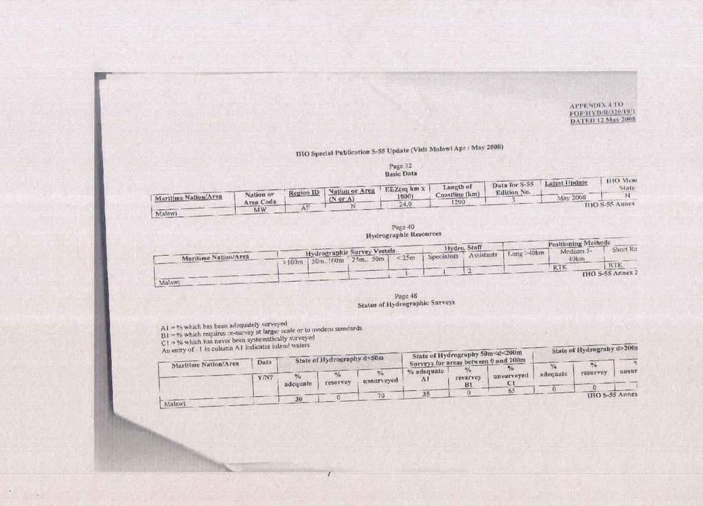
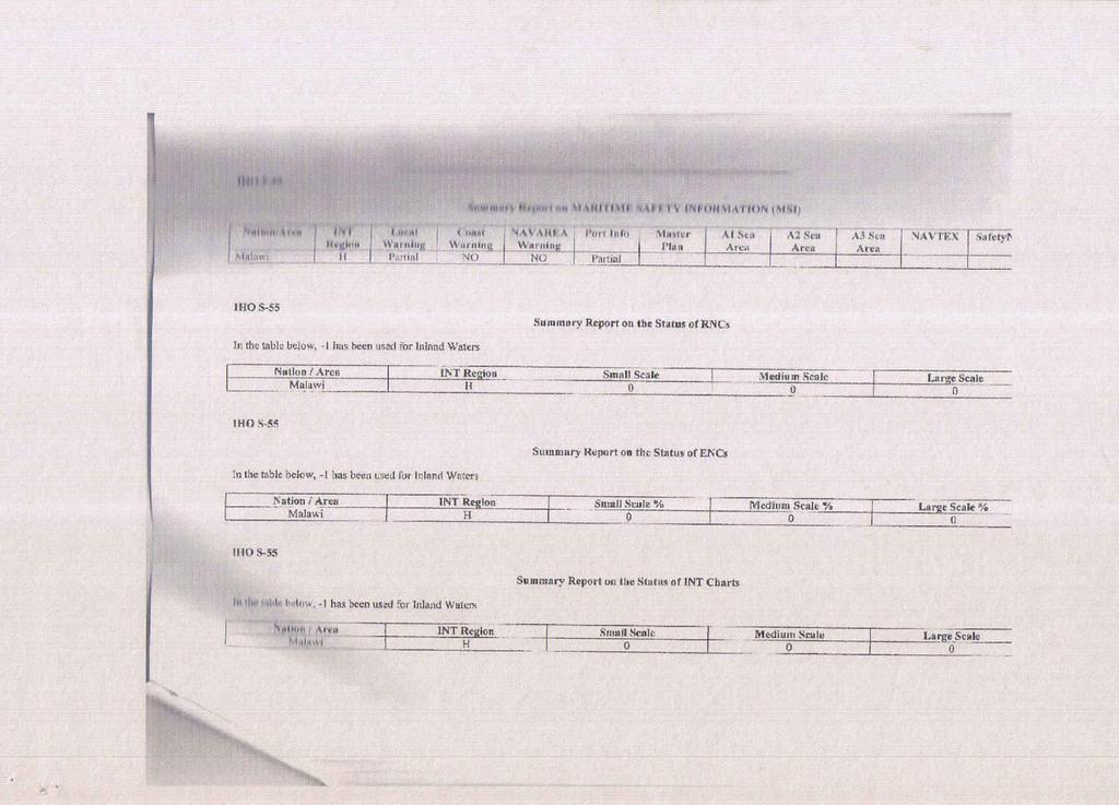
3 4. New Publications & Updates It is planned to carry out surveys on the Nsanje port at the southern tip of Malawi where the Shire River flows into Mozambique, using the vessel RV Timba II. Revision of the Lake Malawi Sailing Directions remains an activity planned for the coming months in close cooperation with the Department of Marine Services. Problems encountered There is lack of trained or experienced personnel in the preparation of the sailing pilot. It is hoped that once the Survey vessel Timba is back to sailing on the lake, there will be an operation together with the Marine Services Department to do the sailing pilot revision. 5. Maritime Safety Information (MSI) Nation/Area INT Region Local Warning Malawi H Partial Lake Malawi pilot update Coast Warning Navarea Warning Port Info Master Plan No No Marine Transport Sector The transmission of safety information to Mariners is the responsibility of Marine Services Department. A communication project which also involves capacity building is in the pipeline. In process also is a Master plan which is a project in conjunction with the EU. The Master Plan is a Marine Transport Sector Master Plan and has started together with Port Development management. IMO will do an audit scheme later this year which will include safety of navigation and indicate importance of charts. Currently, however the main items for communication are still VHF radios which have indeed compromised safety at critical times when ships need urgent rescue. Problems Encountered The Hydrographic Survey office intends to work in close cooperation with Marine Department in order to develop reliable Maritime Safety Information. 6. C-55 The charts are at scales 1:10000, 1:50000 and 1: With the resources at hand the status of hydrography and nautical cartography may be ranked as fairly good. As mentioned above 40% of the
4 lake has been surveyed. Two charts at 1:10000 and four charts at 1:50000 scales have been printed. One chart at 1:10000 and one at 1:50000 chart scales are being printed on demand. Attached find Annex II which shows the C55 status as extracted from the IHOCBC Malawi Visit Report Capacity Building Personnel have been the major input into the achievements made to date. Capacity building is a continuous exercise that need never stall to avoid gaps in delivery. Training is therefore required both in hydrography and nautical cartography. In order to maintain a trained staff, Government has done its part by putting in place a comprehensive training programme. Thus some staff members have been trained at the STC in Netherlands. At the local universities in Blantyre, Mzuzu and Lilongwe training has also been provided in Surveying and Mapping. Other training which also involved cooperating partners as well as the IHOCBC allowed for training in France, Italy and South Africa. Currently training is sought for CAT A training in Hydrography. Malawi and Mozambique have had multilateral agreements involving hydrographic surveys on Lake Malawi (Niassa) which also involved Iceland. The joint project of the lake boundary between Malawi and Mozambique using CARIS Lots software is planned to commence from September It is also anticipated that the cooperation between Malawi Hydrographic office and Norway will come to fruition which will be very helpful to revive the operations of the survey ship RV Timba. Such items as the positioning equipment, the sounding equipment, data logging instruments and accompanying softwares will require revamping and we therefore hope Norwegian Hydrographic office will look with favour at our plight. Another project to be carried out is the Shire-Zambezi waterway project. A new impetus to the project has been assured by the government and cooperating countries to bring new life to this important project. 8. Oceanographic Activities A network of staff tide gauges run the whole stretch of the western coast of Lake Malawi including Lake Malombe and Shire River are maintained by the Ministry of Water and Irrigation department. The hydrographic office maintains one automated pressure tide gauge at Monkey Bay which is fully functional. Additional automatic pressure tide gauges will eventually be installed at Nkhota Kota, Nkhata Bay and Chilumba ports. Other oceanographic equipment used by the hydrographic office includes a sound velocity profiler and a Grab corer.
5 GIZ Germany cooperation has delivered to the hydrographic office a winch and motor, a rubber dinghy, a hydrophore water pump and outboard engine. This is much appreciated and it will be put to good use. Problems encountered There is need to purchase a current meter for inclusion of water current information on the charts. In addition even though the automatic tidegauge has functioned well all these years we are worried that its batteries will come to end of their life very soon and we are not in touch with the supplier to know the how about maintenance. 10. Concluding Remarks The lengthy repair period to the ship Timba has been a major stumbling block to successful continuation of our programmes but it is hoped this will become history this September when the Timba becomes operational again. Based on our past glory it is hoped that future success can be attained in the production of modern navigation charts, revision of the Lake pilot and monitoring the lake and river environment. With the willingness of our cooperating partners such as Iceland, Germany GIZ and Norway who have pledged to support Malawi and others in the international community including the IHO, we hope to get back to our winning ways and achieve those milestones hitherto eluded due to funding or ship breakdown or other such reasons.
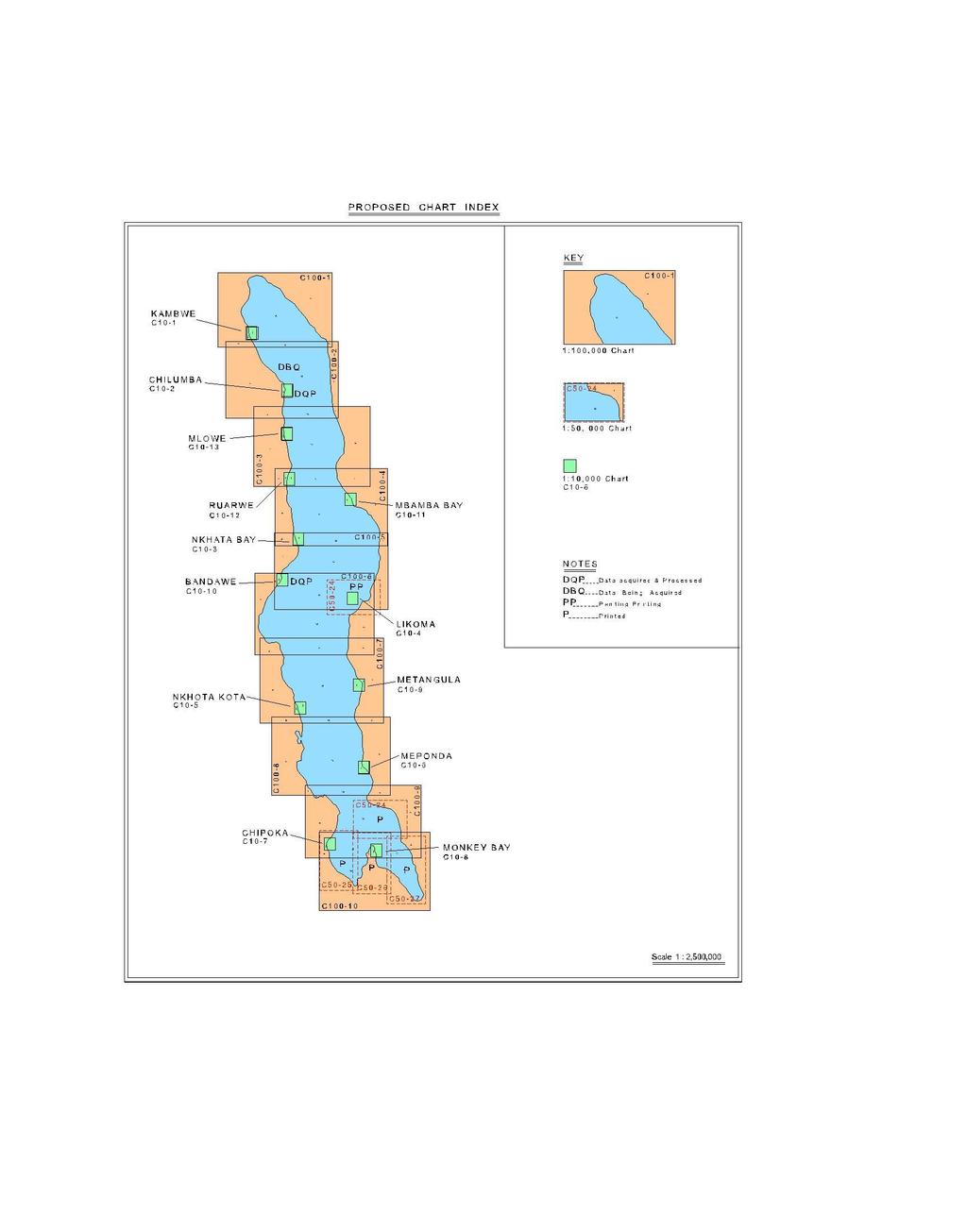
6 ANNEX I
7 ANNEX II
8
There is also need to acquire equipment such as GPS, Echo-Sounder and update data acquisition and processing software among other requirements.
 Malawi National Report 2016 1 Malawi Hydrographic Office The mandate of the Hydrographic office is to carry out surveys of Lake Malawi including the lesser lakes of Malombe, Chilwa and Chiuta as well as
Malawi National Report Malawi Hydrographic Office
 Malawi National Report 2013 1 Malawi Hydrographic Office The Malawi Hydrographic Office was started 30 years after the federal government hydrographic surveys. In the year 1989 the 70-ton ship RV Timba
Myanmar Naval Hydrographic Centre. National Report for 13 th North Indian Ocean Hydrographic Commission Meeting
 Myanmar Naval Hydrographic Centre National Report for 13 th North Indian Ocean Hydrographic Commission Meeting Yangon, Myanmar 19 th 22 nd February 2013 CONTENT 1. Myanmar Naval Hydrographic Centre 2.
EGYPTIAN HYDROGRAPHIC DEPARTMENT THE EGYPTIAN HYDROGRAPHIC FRAMEWORK
 gvt THE EGYPTIAN HYDROGRAPHIC FRAMEWORK The roles of a national Hydrographic Service can be summarized in collecting georeferenced data through systematic surveys at sea and along the coast related to:
MESOAMERICAN AND CARIBBEAN HYDROGRAPHIC COMMISSION 11 th Meeting, Paramaribo, Suriname, Novembro NATIONAL REPORT BRAZIL
 Page 1 of 5 MESOAMERICAN AND CARIBBEAN HYDROGRAPHIC COMMISSION 11 th Meeting, Paramaribo, Suriname, Novembro 8-12 2010 NATIONAL REPORT BRAZIL 1. Hydrographic Office / Service: Directorate of Hydrography
National Report of Finland
 National Report of Finland [31 August 2010] Executive Summary This Report gives an overview of the main activities of the Finnish Hydrographic Office (FHO) since the previous BSHC 14 th Conference. The
Nordic Hydrographic Commission 60th Conference - Stavanger - Norway April New national ENC service for leisure craft users
 Nordic Hydrographic Commission 60th Conference - Stavanger - Norway 11-13 April 2016 New national ENC service for leisure craft users New national ENC service for leisure craft users The aim of the new
Maritime Administration of Latvia Hydrographic Service National Report to Baltic Sea Hydrographic Commission
 Maritime Administration of Latvia Hydrographic Service National Report to Baltic Sea Hydrographic Commission Executive summary 2017 The Report gives an overview of the main activities of Hydrographic Service
PAPUA NEW GUINEA HYDROGRAPHIC SERVICE
 PAPUA NEW GUINEA HYDROGRAPHIC SERVICE IHO SOUTH WEST PACIFIC HYDROGRAPHIC COMMISSION (SWPHC) 9 th Meeting Port Moresby, Papua New Guinea, 10-11 March 2007 SWPHC9-01PNG 1. INTRODUCTION 9 th SOUTH WEST PACIFIC
Maritime Administration of Latvia (MAL) Hydrographic Service National Report to Baltic Sea Hydrographic Commission
 Hydrographic Service National Report to Baltic Sea Hydrographic Commission") Maritime Administration of Latvia (MAL) Hydrographic Service National Report to Baltic Sea Hydrographic Commission Executive summary 2016 The Report gives an overview of the main activities of Hydrographic
Maritime Administration of Latvia (MAL) Hydrographic Service National Report to Baltic Sea Hydrographic Commission Executive summary 2016 The Report gives an overview of the main activities of Hydrographic
DRAFT ASSEMBLY RESOLUTION A. (26)
") DRAFT ASSEMBLY RESOLUTION A. (26) PROMULGATION OF MARITIME SAFETY INFORMATION The ASSEMBLY, RECALLING Article 15(j) of the Convention on the International Maritime Organization concerning the functions
DRAFT ASSEMBLY RESOLUTION A. (26) PROMULGATION OF MARITIME SAFETY INFORMATION The ASSEMBLY, RECALLING Article 15(j) of the Convention on the International Maritime Organization concerning the functions
NOAA s National Ocean Service / Office of Coast Survey
 Coast Survey OCS 1807 2007 Maintains over 1000 nautical charts & 9 Coast Pilots Surveys over 3.4M SNM of oceans and lakes Conducts research and development in hydrography Thomas Jefferson Founder of The
LT Matthew Forney, NOAA Navigation Manager Alaska Region Bering Strait MaritimeSymposium. Office of Coast Survey
 NOAA LT Matthew Forney, NOAA Navigation Manager Alaska Region Bering Strait MaritimeSymposium Who is Coast Survey? First science agency of the U.S. Formed in 1807 Responsible for surveying 3.4 million
A guideline for establishing feature and symbol standard management system for national HOs
 A guideline for establishing feature and symbol standard management system for national HOs Joint 26th TSMAD and 5th DIPWG Meeting Silver Spring, Maryland, USA(10-14 June 2013) Republic of Korea (ROK)
Draft submission paper: Hydrographic Offices way on EMODnet. Subject : Hydrographic Offices way on EMODnet. Foreword :
 Subject : Hydrographic Offices way on EMODnet Foreword : This paper is aimed to present the state of the EMODnet project, the European Commission s policy for this project, the principles of the Hydrographic
AMENDMENTS TO RESOLUTION A.705(17) PROMULGATION OF MARITIME SAFETY INFORMATION
 PROMULGATION OF MARITIME SAFETY INFORMATION") E 4 ALBERT EMBANKMENT LONDON SE1 7SR Telephone: +44 (0)20 7735 7611 Fax: +44 (0)20 7587 3210 AMENDMENTS TO RESOLUTION A.705(17) PROMULGATION OF MARITIME SAFETY INFORMATION MSC.1/Circ.1287/Rev.1 24 June
E 4 ALBERT EMBANKMENT LONDON SE1 7SR Telephone: +44 (0)20 7735 7611 Fax: +44 (0)20 7587 3210 AMENDMENTS TO RESOLUTION A.705(17) PROMULGATION OF MARITIME SAFETY INFORMATION MSC.1/Circ.1287/Rev.1 24 June
1 st MEETING OF THE IHO COUNCIL
 C1-3.1 1 st MEETING OF THE IHO COUNCIL Monaco, 17-19 October 2017 REPORT OF THE IHO HYDROGRAPHIC SERVICES AND STANDARDS COMMITTEE C1-3.1 - P a g e 3 REPORT OF THE HYDROGRAPHIC STANDARDS AND SERVICES COMMITTEE
DEVELOPMENT OF A DEFINITION FOR MSPS AND CONSIDERATION FOR THE HARMONIZATION OF THE FORMAT AND STRUCTURE OF MSPS
 INTERNATIONAL HYDROGRAPHIC ORGANIZATION E IMO/IHO HARMONIZATION GROUP ON DATA MODELLING Agenda item 5 15 September 2017 ENGLISH ONLY DEVELOPMENT OF A DEFINITION FOR MSPS AND CONSIDERATION FOR THE HARMONIZATION
e-navigation Progress and trends: the IHO perspective
 International Hydrographic Organization e-navigation Progress and trends: the IHO perspective Gilles Bessero Director, IHO International Hydrographic Organization Intergovernmental consultative and technical
NHC 59th meeting Agenda item NHC59-9A April 14-15, 2015 Reykjavik - Iceland. New national ENC service for leisure craft users
 NHC 59th meeting Agenda item NHC59-9A April 14-15, 2015 Reykjavik - Iceland New national ENC service for leisure craft users The aim of the new ENC service The aim of the new ENC service is to enhance
56 th NHC Meeting May 21-23, 2012 Copenhagen, Denmark. Draft Minutes. [May 23, 2012]
![56 th NHC Meeting May 21-23, 2012 Copenhagen, Denmark. Draft Minutes. [May 23, 2012]](/thumbs/91/107654306.jpg "56 th NHC Meeting May 21-23, 2012 Copenhagen, Denmark. Draft Minutes. [May 23, 2012]") NHC/56 Draft Minutes 56 th NHC Meeting May 21-23, 2012 Copenhagen, Denmark Draft Minutes [May 23, 2012] Venue: Chair: Secretary: Participants: The Danish Royal Academy of Sciences and Letters, Klasseværelset
NHC/56 Draft Minutes 56 th NHC Meeting May 21-23, 2012 Copenhagen, Denmark Draft Minutes [May 23, 2012] Venue: Chair: Secretary: Participants: The Danish Royal Academy of Sciences and Letters, Klasseværelset
REPORT. Technical Visit THE ISLAMIC REPUBLIC OF IRAN February 2007
 REPORT Technical Visit to THE ISLAMIC REPUBLIC OF IRAN 20-22 February 2007 2 Technical Visit to the Islamic Republic of Iran (IHO Work Program 2007, Tasks 2.1.7 and 2.1.10) 20-22 February 2007 I.- General
Helping Build Your Capacity in Nautical Charting & Hydrography
 Helping Build Your Capacity in Nautical Charting & Hydrography Helping Chart your World Rajesh Alla Riyadh, Kingdom of Saudi Arabia 04-06 March 2013 Company Background Marine Services Capacity Building
SPAIN NATIONAL REPORT/ ეროვნული ანგარიში.
 SPAIN NATIONAL REPORT/ ეროვნული ანგარიში http://www.armada.mde.es/ihm. 2 Index 1. Hydrographic Offices 2. Surveys 3. Charts and updates 4. Publications and updates 5. MSI 6. C-55 7. Capacity Building 8.
National Report of Finland
 National Report of Finland 1. Finnish Hydrographic Office The Finnish Hydrographic Office is organized under The Finnish Transport Agency. The Finnish Transport Agency is responsible for the Finnish roads,
MARITIME SAFETY INFORMATION
 Introduction 1. Maritime Safety Information (MSI) is defined as navigational and meteorological warnings, meteorological forecasts, and other urgent safety-related messages. This information is of vital
NAUTICAL CHARTING IN SMALLER COUNTRIES WITH SHORT COASTLINE - TROUBLES AND ADVANTAGES
 NAUTICAL CHARTING IN SMALLER COUNTRIES WITH SHORT COASTLINE - TROUBLES AND ADVANTAGES Igor KARNICNIK, M.Sc. Dalibor RADOVAN (Geodetic Institute of Slovenia, Jamova 2, Ljubljana, Slovenia; igor.karnicnik@geod-is.si)
UNITED KINGDOM NATIONAL REPORT
 SAIHC12-5.3K UNITED KINGDOM NATIONAL REPORT 12 TH SOUTHERN AFRICA AND ISLANDS HYDROGRAPHIC COMMISSION (SAIHC) MEETING Dar es Salaam, Tanzania 22 nd 23 rd September 2015 This report supplements the UK Generic
MBSHC (Mediterranean and Black Seas Hydrographic Commission) XVII. conference, Greece Jun. 2011
 XVII. conference, Greece Jun. 2011") MBSHC (Mediterranean and Black Seas Hydrographic Commission) XVII. conference, Greece 01. 03. Jun. 2011 National report of SLOVENIA 01. May 2011 MBSHC report - SLOVENIA 1 0 Index 0 Index... 2 1 Hydrographic
MBSHC (Mediterranean and Black Seas Hydrographic Commission) XVII. conference, Greece 01. 03. Jun. 2011 National report of SLOVENIA 01. May 2011 MBSHC report - SLOVENIA 1 0 Index 0 Index... 2 1 Hydrographic
Kordil Surveying & Engineering Services
 Kordil Surveying & Engineering Services About Kordil Kordil Surveying & Engineering Ltd. Co. in short Kordil is an all in one surveying company providing service from Turkey. Hydrography, Oceanography
GLMTF November 18, 2014 Presentation
 GLMTF November 18, 2014 Presentation Michigan Security Network Founded by major corporations, industry leaders and leading universities in 2008 as a non-profit organization (501c6). MiSN mission is to
WWNWS3/3/3/1A Meeting 3 1 August 2011 Agenda Item NAVTEX Panel Report SUMMARY
 WWNWS WWNWS3/3/3/1A Meeting 3 1 August 2011 Agenda Item 3.3.1 NAVTEX Panel Report Submitted by Chair, IMO International NAVTEX Co-ordinating Panel SUMMARY Executive Summary: This report provides a summary
USE OF THE RCDS MODE OF ECDIS (Submissions by Australia and Norway to IMO MSC/78)
") IHB File No. S3/8152 CIRCULAR LETTER 21/2004 22 March 2004 USE OF THE RCDS MODE OF ECDIS (Submissions by Australia and Norway to IMO MSC/78) Ref: 1. WEND Letter 1/2004, dated 1 st February 2004 2. IMO
IHB File No. S3/8152 CIRCULAR LETTER 21/2004 22 March 2004 USE OF THE RCDS MODE OF ECDIS (Submissions by Australia and Norway to IMO MSC/78) Ref: 1. WEND Letter 1/2004, dated 1 st February 2004 2. IMO
CAPACITY BUILDING PLAN Programme document for the period
 INTERNATIONAL HYDROGRAPHIC ORGANIZATION MESO AMERICAN & CARIBBEAN SEA HYDROGRAPHIC COMMISSION 1. INTRODUCTION CAPACITY BUILDING PLAN Programme document for the period 2013-2017 1.1. Rationale It is estimated
IHB File No S3/8151/HSSC CIRCULAR LETTER 11/ February 2009
 CIRCULAR LETTER 11/2009 17 February 2009 REVIEW OF IHO TECHNICAL RESOLUTIONS BY THE COMMITTEE ON HYDROGRAPHIC REQUIREMENTS FOR INFORMATION SYSTEMS (CHRIS) 1 (GROUP 1 OF 4) Reference: IHB CL 93/2008 dated
MEDITERRANEAN AND BLACK SEAS HYDROGRAPHIC COMMISSION
 MEDITERRANEAN AND BLACK SEAS HYDROGRAPHIC COMMISSION XVIII CONFERENCE CONTRIBITION BY MALTA Istanbul, Turkey 25-27 September 2013 1 Item 1 Hydrographic Office Transport Malta is responsible for all transport
There has been some success
 Surveying Hydrography in Africa by Captain Abri Kampfer, Hydrographer SA Navy The International Hydrographic Bureau (IHB) and many member states of the International Hydrographic Organisation (IHO) have
UNITED KINGDOM NATIONAL REPORT
 UNITED KINGDOM NATIONAL REPORT TO THE 10 TH MACHC HYDROGRAPHIC COMMISSION MEETING Barbados 4 5 th November 2009 This report supplements the UK Generic National Report 2009, posted on the UKHO website (www.ukho.gov.uk),
WWNWS9/3/2/XVII_XVIII Meeting 9 21 July 2017 Agenda Item 3.2. MSI Self Assessment NAVAREA XVII_XVIII. Submitted by Canada (Canadian Coast Guard)
") WWNWS WWNWS9/3/2/XVII_XVIII Meeting 9 21 July 2017 Agenda Item 3.2 MSI Self Assessment NAVAREA XVII_XVIII Submitted by Canada (Canadian Coast Guard) SUMMARY Executive Summary: Summary of activities within
WWNWS WWNWS9/3/2/XVII_XVIII Meeting 9 21 July 2017 Agenda Item 3.2 MSI Self Assessment NAVAREA XVII_XVIII Submitted by Canada (Canadian Coast Guard) SUMMARY Executive Summary: Summary of activities within
Emerging Subsea Networks
 FIBRE-TO-PLATFORM CONNECTIVITY, WORKING IN THE 500m ZONE Andrew Lloyd (Global Marine Systems Limited) Email: andrew.lloyd@globalmarinesystems.com Global Marine Systems Ltd, New Saxon House, 1 Winsford
NEW AND AMENDED TRAFFIC SEPARATION SCHEMES
 E 4 ALBERT EMBANKMENT LONDON SE1 7SR Telephone: +44 (0)20 7735 7611 Fax: +44 (0)20 7587 3210 NEW AND AMENDED TRAFFIC SEPARATION SCHEMES COLREG.2/Circ.67 20 May 2016 1 The Maritime Safety Committee, at
SPAIN NATIONAL REPORT. TO THE 12th MEETING OF THE EASTERN ATLANTIC HYDROGRAPHIC COMMISSION (EAtHC)
") SPAIN NATIONAL REPORT TO THE 12th MEETING OF THE EASTERN ATLANTIC HYDROGRAPHIC COMMISSION (EAtHC) LISBOA, PORTUGAL 14-16 NOVEMBER 2012 1. Hydrographic Service Instituto Hidrográfico de la Marina (IHM).
SPAIN NATIONAL REPORT TO THE 12th MEETING OF THE EASTERN ATLANTIC HYDROGRAPHIC COMMISSION (EAtHC) LISBOA, PORTUGAL 14-16 NOVEMBER 2012 1. Hydrographic Service Instituto Hidrográfico de la Marina (IHM).
The Present Status of Small Scale ENC Coverage with Respect to the Allocation of cells to Usage Bands 1 (Overview) and 2 (General).
 and 2 (General).") CHRIS19-06.1E 19 th CHRIS MEETING Rotterdam, Netherlands, 5-9 November 2007 The Present Status of Small Scale ENC Coverage with Respect to the Allocation of cells to Usage Bands 1 (Overview) and 2 (General).
CHRIS19-06.1E 19 th CHRIS MEETING Rotterdam, Netherlands, 5-9 November 2007 The Present Status of Small Scale ENC Coverage with Respect to the Allocation of cells to Usage Bands 1 (Overview) and 2 (General).
Related documents: None
 WWNWS WWNWS4/3/2/VII Meeting 4 23 August 2012 Agenda Item 3.2.VII 1 MSI Self Assessment NAVAREA VII Submitted by: South Africa SUMMARY Executive Summary: This document provides MSI information related
Use of laser bathymetry at the German Baltic Sea coast. 9 November, 2016
 Use of laser bathymetry at the German Baltic Sea coast 9 November, 2016 Content Initial situation and aim of the project Organization and implementation Conclusions and next steps 16.02.2017 Ellmer: Laserbathymetry
PRODUCTS AND SERVICES FOR THE MARITIME COMMUNITY. Ed Martin, Chief Customer Affairs Branch Navigation Services Division Monday, 27 October, 2008
 PRODUCTS AND SERVICES FOR THE MARITIME COMMUNITY Ed Martin, Chief Customer Affairs Branch Navigation Services Division Monday, 27 October, 2008 Coral Reef Conservation International Collaboration Marine
FOREWORD. IHO S-100 Working Group
 IHO International Hydrographic Organization KHOA Korea Hydrographic and Oceanographic Agency MUCH MORE THAN JUST NAUTICAL CHARTS IHO UNIVERSAL HYDROGRAPHIC data MODEL This document was produced with the
Object Detection for Underwater Port Security
 Object Detection for Underwater Port Security Dr. Lloyd Huff LCHUFF CONSULTANCY,LLC Mr. John Thomas TRITON IMAGING,INC Shallow Survey 2012 February 22, 2012 INTRODUCTION I am glad to be here today to make
High resolution seabed mapping A European strategy for the coastal risks and integrated management? Bruno Frachon
 High resolution seabed mapping A European strategy for the coastal risks and integrated management? Bruno Frachon Shared objectives IHO DG MARE CPMR Development of the concept of a Joint European Coastal
NAUTICAL CHARTS OF THE BRAZILIAN COAST FOR SMALL CRAFT
 International Hydrographic Review, Monaco, LXIX(2), September 1992 NAUTICAL CHARTS OF THE BRAZILIAN COAST FOR SMALL CRAFT by Eliana Fernandez LIRA 1and Fernando AMADEO 2 Abstract Brazil, a country of continental
Digital broadcasting systems under development within ITU-R of interest for the maritime community
 Digital broadcasting systems under development within ITU-R of interest for the maritime community Christian RISSONE ANFR rissone@anfr.fr IHO, WWNWS 5 Monaco, 2 nd October 2013 1 Background for the 500
INTERNATIONAL HYDROGRAPHIC ORGANIZATION
 INTERNATIONAL HYDROGRAPHIC ORGANIZATION Report on a SAIHC Seminar on Raising Awareness of Hydrography The Seychelles 27 th August 2018 Jeff Bryant International Training & Capacity Building Manager This
BookletChart. Port-au-Prince (Haiti) NGA Chart A reduced-scale NGA nautical chart for small boaters
 NGA Chart A reduced-scale NGA nautical chart for small boaters") BookletChart Port-au-Prince (Haiti) NGA Chart 26186 A reduced-scale NGA nautical chart for small boaters When possible, use the full-size NGA chart or Electronic Nautical Chart (ENC) for navigation. VHF
BookletChart Port-au-Prince (Haiti) NGA Chart 26186 A reduced-scale NGA nautical chart for small boaters When possible, use the full-size NGA chart or Electronic Nautical Chart (ENC) for navigation. VHF
Harmonisation of the Vertical Reference Systems. of nautical charts around the Baltic Sea
 Harmonisation of the Vertical Reference Systems of nautical charts around the Baltic Sea (29 May 2007) Introduction The BSHC 11 th Conference decided that the current status of vertical reference systems
Study on application in the teaching of ship maneuvering Simulator Haoran Song
 Applied Mechanics and Materials Online: 2013-02-27 ISSN: 1662-7482, Vol. 310, pp 580-583 doi:10.4028/www.scientific.net/amm.310.580 2013 Trans Tech Publications, Switzerland Study on application in the
Challenges and opportunities in the e-navigation Development. Actual projects.
 Challenges and opportunities in the e-navigation Development. Actual projects. John Erik Hagen, Regional Director Oslo, September 2018 What is e-navigation? Efficient transfer of marine information and
... Salient Ocean Issues that have arisen during 2002
 ... As reported in paragraph 62 of the resolution Oceans and the law of the seas, we are especially pleased with the focus for this meeting, given that protecting vulnerable marine ecosystems and safety
Baie de L Acul and Approaches (Haiti) NGA Chart A reduced-scale NGA nautical chart for small boaters
 NGA Chart A reduced-scale NGA nautical chart for small boaters") BookletChart Baie de L Acul and Approaches (Haiti) NGA Chart 26148 A reduced-scale NGA nautical chart for small boaters When possible, use the full-size NGA chart or Electronic Nautical Chart (ENC) for
BookletChart Baie de L Acul and Approaches (Haiti) NGA Chart 26148 A reduced-scale NGA nautical chart for small boaters When possible, use the full-size NGA chart or Electronic Nautical Chart (ENC) for
Marine Institute Job Description
 Marine Institute Job Description Position Contract Service Group Location Temporary Scientific & Technical Officer (STO), Hydrographic Data Processor (INFOMAR) Temporary specified purpose contract for
UNITED KINGDOM NATIONAL REPORT
 Page 1 of 9 UNITED KINGDOM NATIONAL REPORT TO THE 11 th MEETING OF THE MESO AMERICAN AND CARIBBEAN SEA HYDROGRAPHIC COMMISSION Paramaribo, Suriname 8 th 12 th November 2010 NOTE: This report supplements
WWNWS10/2/1-I Meeting July 2018 Agenda Item 2.I. MSI Self Assessment NAVAREA I. Submitted by United Kingdom SUMMARY
 WWNWS WWNWS10/2/1-I Meeting 10 19 July 2018 Agenda Item 2.I MSI Self Assessment NAVAREA I Submitted by United Kingdom SUMMARY Executive Summary: Overview of activities undertaken within NAVAREA I since
THE IHO, ELECTRONIC CHARTING AND THE CHANGING RELATIONSHIP TO PORTS
 International Hydrographic Review, Monaco, LXXI(2), September 1994 THE IHO, ELECTRONIC CHARTING AND THE CHANGING RELATIONSHIP TO PORTS by Rear Admiral Christian ANDREASEN1 (Presented at European Harbour
ROV TRAINING & SUBSEA SOLUTIONS.
 ROV TRAINING & SUBSEA SOLUTIONS www.qstar.es www.rovs.eu The Company The company THE COMPANY Founded in 2007, QSTAR - ROV TRAINING & SUBSEA SOLUTIONS, located in the Canary Islands & Barcelona (Spain)
NEW ZEALAND CHARTING AND NOTICES TO MARINERS
 General Information 1. In accordance with agreements between New Zealand, Australia (AUS) and the British Admiralty (BA) for reducing duplication in charting activities, New Zealand has a defined Charting
Meeting 3 1 August 2011 Agenda Item 3.2. MSI Self Assessment NAVAREA I. Submitted by United Kingdom SUMMARY
 WWNWS WWNWS3/3/2-I Meeting 3 1 August 2011 Agenda Item 3.2 MSI Self Assessment NAVAREA I Submitted by United Kingdom SUMMARY Executive Summary: Overview of activities undertaken within NAVAREA I since
A Report On Tide Gauges In Singapore. 1 The Republic of Singapore is an island city-state situated at the southern tip of
 A Report On Tide Gauges In Singapore Introduction 1 The Republic of Singapore is an island city-state situated at the southern tip of Peninsula Malaysia, approximately 1 north of the equator. It consists
GEO-MARINE TECHNOLOGY, INC. A Geological, Geophysical, and Hydrographic Survey Consultancy
 COMPANY PROFILE OUR MISSION AND TRADE OUR MISSION: OUR TRADE: We few, professional scientists strive to support the objectives of our marine energy and telecommunications clients with cooperation, innovation
ESA IAP Blue Belt demonstration project:
 Page 1 ESA IAP Blue Belt demonstration project: supporting the European Maritime Safety Agency (EMSA) Blue Belt Project, by providing a service based on satellite based AIS data complementing the terrestrial
RESOLUTION MSC.278(85) (adopted on 1 December 2008) ADOPTION OF THE NEW MANDATORY SHIP REPORTING SYSTEM "OFF THE COAST OF PORTUGAL - COPREP"
 (adopted on 1 December 2008) ADOPTION OF THE NEW MANDATORY SHIP REPORTING SYSTEM OFF THE COAST OF PORTUGAL - COPREP") MSC 85/26/Add.1 RESOLUTION MSC.278(85) SYSTEM OFF THE COAST OF PORTUGAL COPREP THE MARITIME SAFETY COMMITTEE, RECALLING Article 28 of the Convention on the International Maritime Organization concerning
MSC 85/26/Add.1 RESOLUTION MSC.278(85) SYSTEM OFF THE COAST OF PORTUGAL COPREP THE MARITIME SAFETY COMMITTEE, RECALLING Article 28 of the Convention on the International Maritime Organization concerning
ROUTEING OF SHIPS, SHIP REPORTING AND RELATED MATTERS. Establishment of a Mandatory Ship Reporting System in the
 INTERNATIONAL MARITIME ORGANIZATION E SUB-COMMITTEE ON SAFETY OF NAVIGATION 48th session Agenda item 3 IMO NAV 48/3/2 11 April 2002 Original: ENGLISH ROUTEING OF SHIPS, SHIP REPORTING AND RELATED MATTERS
Passages Between Acklins Island, Haiti and Caicos Islands NGA Chart A reduced-scale NGA nautical chart for small boaters
 BookletChart Passages Between Acklins Island, Haiti and Caicos Islands NGA Chart 26260 A reduced-scale NGA nautical chart for small boaters When possible, use the full-size NGA chart or Electronic Nautical
SOUTH AFRICAN NAVY HYDROGRAPHIC OFFICE
 SOUTH AFRICAN NAVY HYDROGRAPHIC OFFICE GLOSS National Report for South Africa 2009 Compiled by Ms Ruth Farre Superintendent Tidal Information 1. Introduction The South African coastline is approximately
INTERNATIONAL STANDARD
 INTERNATIONAL STANDARD IEC 61174 Second edition 2001-10 Maritime navigation and radiocommunication equipment and systems Electronic chart display and information system (ECDIS) Operational and performance
NAVIGA TIONAL VIGA WARNINGS/MSI/GMDSS N NAV NA AREA III VIII
 NAVIGATIONAL WARNINGS/MSI/GMDSS IN NAVAREA VIII 5/16/2008 1 SCOPE OF PRESENTATION 1. Introduction 2. Navarea VIII Radio Warnings 3. Indian Notices to Mariners 4. Implementation of GMDSS 5. Marine Safety
Meeting 9 4 August 2017 Agenda Item 3.2. MSI Self Assessment NAVAREA I. Submitted by United Kingdom SUMMARY
 WWNWS WWNWS9/3/2/I Meeting 9 4 August 2017 Agenda Item 3.2 MSI Self Assessment NAVAREA I Submitted by United Kingdom SUMMARY Executive Summary: Overview of activities undertaken within NAVAREA I since
GUIDANCE FOR THE PRESENTATION AND DISPLAY OF AIS APPLICATION-SPECIFIC MESSAGES INFORMATION
 E 4 ALBERT EMBANKMENT LONDON SE1 7SR Telephone: +44 (0)20 7735 7611 Fax: +44 (0)20 7587 3210 Ref. T2-OSS/2.7.1 SN.1/Circ.290 2 June 2010 GUIDANCE FOR THE PRESENTATION AND DISPLAY OF AIS APPLICATION-SPECIFIC
BookletChart. Approaches to Cap-Haitien and Bahia de Monti Cristi NGA Chart A reduced-scale NGA nautical chart for small boaters
 BookletChart Approaches to Cap-Haitien and Bahia de Monti Cristi NGA Chart 26142 A reduced-scale NGA nautical chart for small boaters When possible, use the full-size NGA chart or Electronic Nautical Chart
NOAA Navigation Services Update
 NOAA Navigation Services Update Captain Jim Crocker Chief, Navigation Services Division NOAA s More than Two Centuries of Service First U.S. gov t science agency President Thomas Jefferson created the
Korea s Strategy for e-navigation. SMART-Navigation. Presented by. Bu Young, Kim. 28 May Ministry of Oceans and Fisheries Republic of Korea
 Korea s Strategy for e-navigation SMART-Navigation Presented by Bu Young, Kim 28 May 2014 Ministry of Oceans and Fisheries Republic of Korea 1 2 3 4 5 6 1. SMART- Navigation? SMART-Navigation Korea s
RULES FOR THE CONSTRUCTION AND CLASSIFICATION OF MOBILE OFFSHORE DRILLING UNITS TITLE MOBILE OFFSHORE DRILLING UNITS NAUTIC AND ELECTRONICS CHAPTERS
 PARTE II RULES FOR THE CONSTRUCTION AND CLASSIFICATION OF MOBILE OFFSHORE DRILLING UNITS TITLE MOBILE OFFSHORE DRILLING UNITS SECTION 8 NAUTIC AND ELECTRONICS CHAPTERS A B C D SCOPE TECHNICAL DOCUMENTATION
THIS CIRCULAR LETTER REQUIRES YOU TO VOTE. IHB File No. S3/8151/CHRIS CIRCULAR LETTER 93/ November 2008
 THIS CIRCULAR LETTER REQUIRES YOU TO VOTE IHB File No. S3/8151/CHRIS CIRCULAR LETTER 93/2008 17 November 2008 REVIEW OF IHO TECHNICAL RESOLUTIONS BY THE COMMITTEE ON HYDROGRAPHIC REQUIREMENTS FOR INFORMATION
11 th CHRIS MEETING IHB, Monaco, November Draft - - -
 CHRIS/11/16A 11 th CHRIS MEETING IHB, Monaco, 16-18 November 1999 - - - Draft - - - Workshop on Development of Marine Information Objects (MIO) for ECDIS Burlington, Ontario, Canada 8-9 November 1999 Record
MSI Self Assessment NAVAREA V. Submitted by BRAZIL SUMMARY. Executive Summary: NAVAREA V provides the paper of MSI Self Assessment for PRNW1 (WWNWS1)
") WWNWS WWNWS1/3/2/V Meeting 1 16 July 2009 Agenda Item 3.2 MSI Self Assessment NAVAREA V Submitted by BRAZIL SUMMARY Executive Summary: NAVAREA V provides the paper of MSI Self Assessment for PRNW1 (WWNWS1)
WWNWS WWNWS1/3/2/V Meeting 1 16 July 2009 Agenda Item 3.2 MSI Self Assessment NAVAREA V Submitted by BRAZIL SUMMARY Executive Summary: NAVAREA V provides the paper of MSI Self Assessment for PRNW1 (WWNWS1)
NEW ZEALAND NOTICES TO MARINERS
 NEW ZEALAND NOTICES TO MARINERS Notice NZ 133 133 Published fortnightly by the New Zealand Hydrographic Authority Crown Copyright 2018. All rights reserved. Permission is not required to make analogue
17 th BSHC Conference National Report of Germany
 17 th BSHC Conference National Report of Germany FINAL VERSION August 2012 Executive Summary The present report outlines and summarizes the activities carried out since the 16th BSHC Conference by the
IMO RESOLUTION A.1001(25) Adopted on 29 November 2007 (Agenda item 9)
 Adopted on 29 November 2007 (Agenda item 9)") INTERNATIONAL MARITIME ORGANIZATION E IMO ASSEMBLY 25th session Agenda item 9 A 25/Res.1001 3 January 2008 Original: ENGLISH RESOLUTION A.1001(25) Adopted on 29 November 2007 (Agenda item 9) CRITERIA FOR
INTERNATIONAL MARITIME ORGANIZATION E IMO ASSEMBLY 25th session Agenda item 9 A 25/Res.1001 3 January 2008 Original: ENGLISH RESOLUTION A.1001(25) Adopted on 29 November 2007 (Agenda item 9) CRITERIA FOR
MEDITERRANEAN AND BLACK SEAS HYDROGRAPHIC COMMISSION XVI CONFERENCE CONTRIBUTION BY CROATIA
 MEDITERRANEAN AND BLACK SEAS HYDROGRAPHIC COMMISSION XVI CONFERENCE CONTRIBUTION BY CROATIA UKRAINE, Odessa 22-24 September 2009 CONTENTS... 1 1. HYDROGRAPHIC OFFICE... 2 2. SURVEYS... 2 2.1. Survey status...
WWNWS9/3/2/XVI/Rev.1 Meeting 9 22 August 2017 Agenda Item 3.2. MSI Self Assessment NAVAREA XVI. Submitted by
 WWNWS9 WWNWS9/3/2/XVI/Rev.1 Meeting 9 22 August 2017 Agenda Item 3.2 MSI Self Assessment NAVAREA XVI Submitted by PERÚ - DIRECTORATE OF HYDROGRAPHY AND NAVIGATION SUMMARY Executive Summary: Report of activities
Route Planning & Cable Route Surveys
 Route Planning & Cable Route Surveys Graham Evans Director EGS Survey Group www.egssurvey.com Concept to Reality Key Phases Development of Business Model Definition of Key Project Milestones Project Concept
European Radio Navigation Plan. Gilles LEQUEUX, European Commission Policy Development and Strategies
 European Radio Navigation Plan Gilles LEQUEUX, European Commission Policy Development and Strategies CONTEXT - BENEFITS Space Strategy for Europe Introduction of EGNSS in EU sectoral policies Better strategic
AMENDMENTS TO RESOLUTION A.706(17) WORLD-WIDE NAVIGATIONAL WARNING SERVICE
 WORLD-WIDE NAVIGATIONAL WARNING SERVICE") E 4 ALBERT EMBANKMENT LONDON SE1 7SR Telephone: +44 (0)20 7735 7611 Fax: +44 (0)20 7587 3210 AMENDMENTS TO RESOLUTION A.706(17) WORLD-WIDE NAVIGATIONAL WARNING SERVICE MSC.1/Circ.1288/Rev.1 24 June 2013
E 4 ALBERT EMBANKMENT LONDON SE1 7SR Telephone: +44 (0)20 7735 7611 Fax: +44 (0)20 7587 3210 AMENDMENTS TO RESOLUTION A.706(17) WORLD-WIDE NAVIGATIONAL WARNING SERVICE MSC.1/Circ.1288/Rev.1 24 June 2013
NEW ZEALAND NOTICES TO MARINERS
 NEW ZEALAND NOTICES TO MARINERS Notices NZ 147-148 Published fortnightly by the New Zealand Hydrographic Authority Crown Copyright 2018. All rights reserved. Permission is not required to make analogue
Global Maritime Distress and Safety System (GMDSS)
") Global Maritime Distress and Safety System (GMDSS) Global Maritime Distress and Safety System (GMDSS) BACKGROUNG, APPLICATION, DEFINITION GMDSS (Background) SOLAS 74 Ships 1600 TRG Radio Installation Ships
Global Maritime Distress and Safety System (GMDSS) Global Maritime Distress and Safety System (GMDSS) BACKGROUNG, APPLICATION, DEFINITION GMDSS (Background) SOLAS 74 Ships 1600 TRG Radio Installation Ships
BookletChart. Sacramento River Andrus Island to Sacramento NOAA Chart A reduced-scale NOAA nautical chart for small boaters
 BookletChart Sacramento River Andrus Island to Sacramento NOAA Chart 18662 A reduced-scale NOAA nautical chart for small boaters When possible, use the full-size NOAA chart for navigation. Included Area
SECTION III NM 24/15 MARINE INFORMATION
 SECTION III NM 24/15 MARINE INFORMATION NATIONAL GEOSPATIAL-INTELLIGENCE AGENCY'S (NGA) GUIDANCE ON THE PROPER DISPLAY SCALE OF DIGITAL NAUTICAL CHART (DNC) DATA The DNC portfolio was originally created
New Funding Opportunities to Support Safety of Navigation: EGNOS and Galileo
 New Funding Opportunities to Support Safety of Navigation: EGNOS and Galileo e-navigation Underway 31 January-2 February 2017 GSA 2016 The European GNSS Agency (GSA) today: Staff: about 145 Nationalities:
COOK INLET NAVIGATION CHANNEL
 COOK INLET NAVIGATION CHANNEL 1-5 COOK INLET NAVIGATION CHANNEL, ALASKA (CWIS NO. 10324, 10534) Condition of Improvement 30 September 2011 AUTHORIZATION: (1) Water Resources Development Act of 1996 (Public
BookletChart. Cap-Haitien NGA Chart A reduced-scale NGA nautical chart for small boaters
 BookletChart Cap-Haitien NGA Chart 26146 A reduced-scale NGA nautical chart for small boaters When possible, use the full-size NGA chart or Electronic Nautical Chart (ENC) for navigation. VHF Marine Radio
RECOMMENDATIONS LDAC CONFERENCE ON EXTERNAL DIMENSION OF THE CFP LAS PALMAS DE GRAN CANARIA, September 2015
 RECOMMENDATIONS LDAC CONFERENCE ON EXTERNAL DIMENSION OF THE CFP LAS PALMAS DE GRAN CANARIA, 16-17 September 2015 GENERAL STATEMENTS 1. We recognise the progress made with the latest reforms to the exterior
This circular summarizes the various important aspects of the LRIT system with a view to enabling companies to ensure compliance in a timely manner.
 Luxembourg, 29/10/2008 CIRCULAR CAM 02/2008 N/Réf. : AH/63353 Subject : Long-Range Identification and Tracking of Ships (LRIT) To : All ship owners, ship operators and designated persons of Luxembourg