Mobile Platform Observations in the Gulf of Mexico
|
|
|
- Ethel Lyons
- 5 years ago
- Views:
Transcription
1 Mobile Platform Observations in the Gulf of Mexico 1), Steven Meyers 2), Mark E. Luther 2) 1) Helmholtz Centre Geestacht, Institute of Coastal Research, Geesthacht, Germany 2) University of South Florida, College of Marine Science, St. Petersburg FL, USA Origin and Technique of Seakeepers Data and Meta Data Availability Space/Time Structure of the data Quality of the data Assessment of the present situation

2 Report about integration of mobile observation platform data into GCOOS:
3 Origin of Seakeepers When SeaKeepers Society began 1998, the premise was simple, specific, and altruistic. Could a group of private yacht owners effectively create a new system for oceanographic monitoring, utilizing their vessels as the initial platform for deployment? Could the system play a meaningful role in helping to measure what is happening in the sea with the ultimate purpose of aiding conservation of the declining marine ecosystem? Mission of Seakeepers to gather and distribute the most useful oceanographic and atmospheric data from which to draw rational conclusions concerning the health of the world s oceans and climate. This data is provided to governments, scientists, educational institutions and private citizens throughout the world.

4 Cruise tracks Number of installations 70 actual > 90 since 1998 Commercial Ships NOAA Buoys Private Yachts United States Coast Guard Ice Breaker Lighthouses Piers


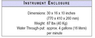
5 Technique Seakeeper 1000 Components YSI Appointed Exclusive Licensee Water intake and antifouling device Outside hull Inside hull

6 Technique No Sampling

7 Technique USF College of Marine Science Backscatter, Chl-a, CDOM
8 Data types 1 minute high resolution ( raw ) data Stored at onboard computer; downloaded and archived by Seakeepers Society Not included in the data portals Transmitted data Based on 1 min data transmission via Satcom C each three (one) hours transmitted data tuples are averages of the last 10 minutes before transmission

")
9 Near real-time data portals Where do I find the data? And what data? No link from Seakeepers Society web pages (or any else) Contains meteo- and oceanographic standard sensor data Data quality (window with wide ranges) coded in colours No data plots Works only with

10 Near real-time data portals For internal use and hence only basic functionality: directory with link to files Contains sensor data beyond meteo- and oceanogr. standard Clumsy data format No quality check
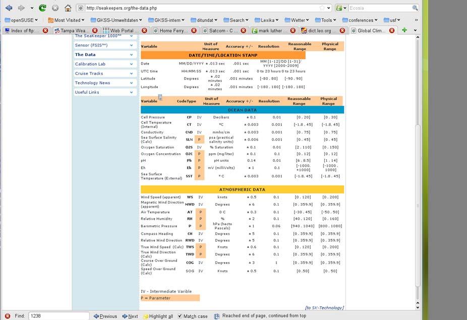
11 Meta data


12 Where and When All tracks of satellite data transmissions June Carnival Miracle


13 Where and When All tracks of satellite data transmissions June 2011 Manta/NOAA
14 Latitude Examples of data FLORIDA The problem of transmitted data (10 minute averages) High resolution (1 min) data Salinity Salinity transmitted data Longitude Time

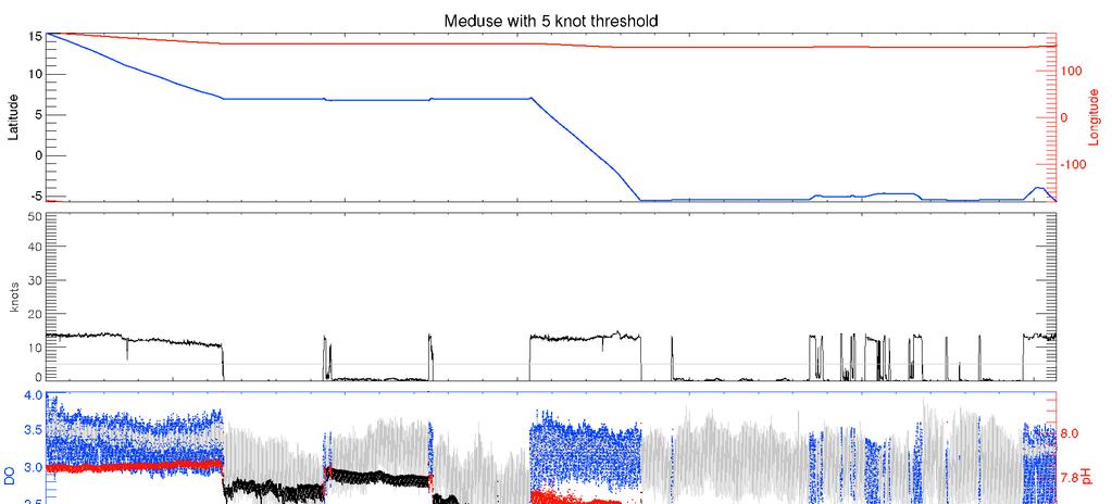

15 Examples of data High resolution (1 min) data Meduse Meduse


![[kgm -3 ]](/docs-images/93/114320869/images/16-3.jpg "Cuba")


16 Examples of data Belice N Oxygen conc. [kgm -3 ] Cuba Florida Salinity SST [ o C]
![2008-2011 SST [ o C] Manta](/docs-images/93/114320869/images/17-0.jpg "Oxygen conc.")
17 SST [ o C] Manta Oxygen conc. [kgm -3 ] Salinity
18 Summary For the Gulf of Mexico Only one 3 years data series on a defined track ( Carnival Miracle ) In most cases data too sporadic and not guided by clear objectives Large parts of the Gulf not covered In general Limited and difficult data access for outsiders Limited meta data information To establish working procedures that deliver high Data quality quality limited: and informative long-term observations Maintenance of the systems and re-calibration scheme of the sensors intransparent projects with for outsiders; clear scientific and/or coastal Quality management of the data objectives limited are required No system control parameters (e.g. operation of pumps) recorded No sampling Without access to the high-resolution data Seakeepers data can not be corrected and interpreted Until recently, obviously nobody had looked critically at the oceanographic data No publications in refereed journals using Seakeeper data
Argo. 1,000m: drift approx. 9 days. Total cycle time: 10 days. Float transmits data to users via satellite. Descent to depth: 6 hours
 Float transmits data to users via satellite Total cycle time: 10 days Descent to depth: 6 hours 1,000m: drift approx. 9 days Temperature and salinity profiles are recorded during ascent: 6 hours Float
Measuring Currents from Aids-to-Navigation Buoys
 Measuring Currents from Aids-to-Navigation Buoys Recent Design Improvements Bob Heitsenrether Kate Bosley, PhD Kasey Hall Overview CO-OPS Background NOAA s Physical Oceanographic Real-time System (PORTS
NRL Glider Data Report for the Shelf-Slope Experiment
 Naval Research Laboratory Stennis Space Center, MS 39529-5004 NRL/MR/7330--17-9716 NRL Glider Data Report for the Shelf-Slope Experiment Joel Wesson Jeffrey W. Book Sherwin Ladner Andrew Quaid Ian Martens
Recent Developments in NOAA s Real- Time Coastal Observing Systems for Safe and Efficient Maritime Transportation
 Recent Developments in NOAA s Real- Time Coastal Observing Systems for Safe and Efficient Maritime Transportation Rich Edwing, Director NOAA Center for Operational Oceanographic Products and Services CMTS
The Shipboard Automated Meteorological and Oceanographic Systems (SAMOS) Initiative
 Initiative") The Shipboard Automated Meteorological and Oceanographic Systems (SAMOS) Initiative Shawn R. Smith Center for Ocean-Atmospheric Prediction Studies Florida State University, Tallahassee, FL USA smith@coaps.fsu.edu
The Shipboard Automated Meteorological and Oceanographic Systems (SAMOS) Initiative Shawn R. Smith Center for Ocean-Atmospheric Prediction Studies Florida State University, Tallahassee, FL USA smith@coaps.fsu.edu
Progress in Refreshing the Tropical Atmosphere Ocean (TAO) Array
 Array") Progress in Refreshing the Tropical Atmosphere Ocean (TAO) Array Richard L. Crout, PhD, Dawn Petraitis, Lex LeBlanc, Landry J. Bernard, and Karen Grissom NOAA/NWS National Data Buoy Center Stennis Space
Progress in Refreshing the Tropical Atmosphere Ocean (TAO) Array Richard L. Crout, PhD, Dawn Petraitis, Lex LeBlanc, Landry J. Bernard, and Karen Grissom NOAA/NWS National Data Buoy Center Stennis Space
Surface T/S Data RV "Heincke" HE412
 Surface T/S Data RV "Heincke" HE412 Data Processing Report Contents 1 Introduction 1 2 Workflow 1 3 Cruise details 2 4 Sensor 2 5 Processing Report 3 Contact: Gerd Rohardt Alfred-Wegener-Institute Am Handelshafen
Surface T/S Data RV "Heincke" HE303
 Surface T/S Data RV "Heincke" HE303 Data Processing Report Contents 1 Introduction 1 2 Workflow 1 3 Cruise details 2 4 Sensor 2 5 Processing Report 3 Contact: Gerd Rohardt Alfred-Wegener-Institute Am Handelshafen
Use of Knowledge Modeling to Characterize the NOAA Observing System Architecture
 Use of Knowledge Modeling to Characterize the NOAA Observing System Architecture Presentation to The Open Group Architecture Practitioner s Conference 23 October 2003 James N Martin The Aerospace Corporation
Programmatic Updates & Perspectives Julie Thomas Executive Director, SCCOOS
 Programmatic Updates & Perspectives Julie Thomas Executive Director, SCCOOS Board of Governors Meeting Hyperion Water Reclamation Plant Los Angeles December 3,2015 Southern California Coastal Ocean Observing
Real-Time Continuous Observations of Lake Erie Chemical, Biological, and Physical Parameters
 Real-Time Continuous Observations of Lake Erie Chemical, Biological, and Physical Parameters S. Ruberg 1, S. Brandt 1, S. Gordon 2, R. Muzzi 1 1. NOAA Great Lakes Environmental Research Lab (GLERL) 2.
Pioneer Array Micro-siting Meeting
 Ocean Observatories Initiative Pioneer Array Micro-siting Meeting June 7, 2011 Coastal Institute University of Rhode Island June 7, 2011 PIONEER ARRAY MICRO-SITING MEETING AGENDA Welcome, Introduction
BookletChart. Intracoastal Waterway Grassy Key to Bahia Honda Key NOAA Chart A reduced-scale NOAA nautical chart for small boaters
 BookletChart Intracoastal Waterway Grassy Key to Bahia Honda Key NOAA Chart 11453 A reduced-scale NOAA nautical chart for small boaters When possible, use the full-size NOAA chart for navigation. Published
Co-ReSyF RA lecture: Vessel detection and oil spill detection
 This project has received funding from the European Union s Horizon 2020 Research and Innovation Programme under grant agreement no 687289 Co-ReSyF RA lecture: Vessel detection and oil spill detection
Recommendations from the High-Resolution Marine Meteorology Workshop
 Recommendations from the High-Resolution Marine Meteorology Workshop 3-5 March 2003 Center for Ocean-Atmospheric Prediction Studies Florida State University Tallahassee, FL USA Foreword A new initiative
GOCI Status and Cooperation with CoastColour Project
 GOCI Status and Cooperation with CoastColour Project Joo-Hyung RYU Contribution from : KOSC colleaques Nov. 17, 2010 World 1 st GOCI/COMS Launch Campaign Launch Date : June 27 2010 Launch Vehicle : Ariane-V
SCIENCE MEDIA EXPLORATION
 SCIENCE MEDIA EXPLORATION THE GREATEST EXPEDITIONS BEGIN WITH STATE-OF-THE-ART RESOURCES. INTRODUCING ALUCIA. A UNIQUE BLEND OF RESEARCH CAPABILITIES WITH MEDIA EXPERTISE. INFINITE POSSIBILITIES. The ALUCIA
South African Argo Report
 South African Argo Report Juliet@saeon.ac.za, johan.stander@weathersa.co.za, isabelle.ansorge@uct.ac.za South Africa has not purchased any further Argo floats but remains active and committed to the Argo
Future of Sustained Observations
 Future of Sustained Observations OceanObs 09 identified tremendous opportunities, significant challenges Called for a framework for planning and moving forward with an enhanced global sustained ocean observing
Real-Time Current Measurements Improve Vessel Safety and Port Efficiency
 REPRINT Real-Time Current Measurements Improve Vessel Safety and Port Efficiency The ATON System Provides Port Decision Makers With a Reliable and Cost-Effective Alternative in Real-Time Current Monitoring
MERIS data access over diagnostic sites for calibration and validation purposes
 MERIS data access over diagnostic sites for calibration and validation purposes Philippe Goryl ESA / ESRIN Philippe.Goryl@esa.int Carsten Brockman Brockman Consult Workshop on Inter-Comparison of Large
Underwater Vehicle Systems at IFREMER. From R&D to operational systems. Jan Opderbecke IFREMER Unit for Underwater Systems
 Underwater Vehicle Systems at IFREMER From R&D to operational systems Jan Opderbecke IFREMER Unit for Underwater Systems Operational Engineering Mechanical and systems engineering Marine robotics, mapping,
/$ IEEE 1832 PROGRESS REPORT ON THE USE OF A CRUISE LINER AS A VESSEL OF OPPORTUNITY FOR COLLECTING SCIENTIFIC DATA
 PROGRESS REPORT ON THE USE OF A CRUISE LINER AS A VESSEL OF OPPORTUNITY FOR COLLECTING SCIENTIFIC DATA James Fahey, RD Instruments Darryl Symonds, RD Instruments Richard Findley, Scientific Liaison, University
De-recruitments In 2012
 VOS / p. 1 VOS Report for 2012 (Canada) a. Programme description: Category No. of ships at 31 Dec 2012 Recruitments in 2012 De-recruitments In 2012 Comments Selected Selected AWS VOSClim VOSClim AWS 51
Japanese Argo Program
 PICES XV Oct15, 2006 Japanese Argo Program Nobie Shikama (JAMSTEC) What is Argo? Argo is a global ocean monitoring network of 3,000 floats which measure T-S profile of upper 2,000m every 10 days and transmit
Xylem Analytics. Ocean & Coastal Monitoring Solutions
 Xylem Analytics Ocean & Coastal Monitoring Solutions Coastal Research Environmental Monitoring Ferrybox Aquaculture System Integration Recovery Marine Transport Offshore Installation Oceanography Oil &
Cost Effective Control of your Coastal Waters
 Cost Effective Control of your Coastal Waters Olov Fäst SSC Airborne Systems 2013-07-03 SSC: A comprehensive space industry Founded in 1972 ~650 employees (2012) ~100 M turnover (2012) Since the start
Galileo signal reflections used for monitoring waves and weather at sea
 Press Release Monday 26 th November 2007 Galileo signal reflections used for monitoring waves and weather at sea Surrey Satellite Technology Ltd (SSTL) and the University of Surrey have succeeded for the
A Space-Based Solution for Illegal, Unregulated & Unreported Fishing. Emmanouil Detsis, International Space University
 Project Catch A Space-Based Solution for Illegal, Unregulated & Unreported Fishing Emmanouil Detsis, International Space University Project Catch COPUOS Presentation Team Project Oceans International Intercultural
Ocean Observations Erik Buch EuroGOOS chair
 EB1 EB2 Ocean Observations Erik Buch EuroGOOS chair 15-07-2015 EuroGOOS AISBL eurogoos@eurogoos.eu - http://www.eurogoos.eu 1 Slide 1 EB1 Erik Buch, 2/26/2014 EB2 Erik Buch, 2/26/2014 Maritime activities
Satellite services and products for Automatic Weather Stations. Sophie Baudel
 Satellite services and products for Automatic Weather Stations Sophie Baudel sbaudel@cls.fr Share basic knowledge on telemetry services used by meteorologists and oceanographers for autonomous platforms
Ozobot Bit. Computer Science Engineering Program
 3 rd Grade Ozobot Bit Computer Science Engineering Program Post Visit Activity Resources 2018 Winter/Spring 2018 Dear Third Grade Visiting Classroom Teacher, It is hoped that you and your students enjoyed
Recommended Iridium SBD dataformats for buoys
 Recommended Iridium SBD dataformats for buoys By Pierre Blouch, Christophe Billon, Paul Poli, Météo-France Version 1.7 28 June 2018 The present document describes a list of dataformats which should be
The Alliance for Coastal Technologies
 The Alliance for Coastal Technologies Supporting the Technical Education & Training Needs of Tomorrow s Ocean Observing Workforce Ali L. Hudon ACT Gulf of Mexico Partner Education & Outreach Coordinator
 WWW.SEACHANGEPROJECT.EU An Ocean Literate person:» Understands the importance of the ocean to humankind;» Can communicate about the ocean in a meaningful way; and» Is able to make informed and responsible
Department of Science and Technology Parthenope University Naples
 Department of Science and Technology Parthenope University Naples A.A. 2013-2014 First Level Degree Course in COMPUTER SCIENCE (class L-31 DM 47) Computer Architecture with Lab. INF/01 12 Mathematics I
Reprint
 Reprint www.sea-technology.com Through-the-Hull Acoustic Communication Technology Ships Hulls as a Wireless Medium for Networking and Data Transfer Among Spatially Distributed Sensors By Kushal Talukdar
The Nordic Institute of Navigation (NNF)
") The Nordic Institute of Navigation (NNF) www.nornav.org non-profit, independent and a non-political organization for professionals working within the field of navigation. The focus of NNF is on all aspects
The Nordic Institute of Navigation (NNF) www.nornav.org non-profit, independent and a non-political organization for professionals working within the field of navigation. The focus of NNF is on all aspects
SMOS mission: a new way for monitoring Sea Surface Salinity?
 SMOS mission: a new way for monitoring Sea Surface Salinity? J. Boutin (1) (1) Laboratoire d Oceanographie et du Climat- Expérimentation et Applications Numériques (LOCEAN), PARIS, FRANCE Thanks to T.
Argo watches the Oceans
 A Argo watches the Oceans Howard Freeland Argo Director at Institute of Ocean Sciences, Sidney, BC, Canada Tel: (250)-363-6590 Email: Howard.Freeland@pac.dfo-mpo.gc.ca Why are we doing Argo? Measurements
Hydroacoustic Aided Inertial Navigation System - HAIN A New Reference for DP
 Return to Session Directory Return to Session Directory Doug Phillips Failure is an Option DYNAMIC POSITIONING CONFERENCE October 9-10, 2007 Sensors Hydroacoustic Aided Inertial Navigation System - HAIN
The present 5-year cycle of U.S. Argo implementation began in July 2015, and extends through June 2020.
 U.S. Argo National Report to AST-18, March 2017. Organization of U.S. Argo: The U.S. Argo Program is supported with major funding provided by the National Oceanic and Atmospheric Administration (NOAA),
International Journal of Advance Engineering and Research Development ADVANCED NAVIGATOR AND MONITORING SYSTEM FOR FISHERMAN
 Scientific Journal of Impact Factor(SJIF): 3.134 International Journal of Advance Engineering and Research Development Volume 3,Issue 3, March -2016 e-issn(o): 2348-4470 p-issn(p): 2348-6406 ADVANCED NAVIGATOR
OC3570 PROJECT REPORT: A COMPARISON OF COASTAL CURRENTS USING LAND BASED HF RADAR AND SHIP BOARD ADCP OBSERVATIONS. LCDR Steve Wall, RAN Winter 2007
 OC3570 PROJECT REPORT: A COMPARISON OF COASTAL CURRENTS USING LAND BASED HF RADAR AND SHIP BOARD ADCP OBSERVATIONS LCDR Steve Wall, RAN Winter 2007 Background High Frequency (HF) radar between 3 and 30MHz
Wave Measurement Evaluation and Testing. Geneva, SWITZERLAND 4 Scripps Institution of Oceanography, La Jolla, CA, USA
 Wave Measurement Evaluation and Testing R. Jensen 1, V. Swail 2,, B. Lee 3, W.A. O Reilly 4 1 Engineer Research and Development Center, USACE, Vicksburg, MS, USA 2 Environment Canada, Toronto, Ontario,
Marine Sensor/Autonomous Underwater Vehicle Integration Project
 Marine Sensor/Autonomous Underwater Vehicle Integration Project Dr. Thomas L. Hopkins Department of Marine Science University of South Florida St. Petersburg, FL 33701-5016 phone: (727) 553-1501 fax: (727)
Mapping Surface Currents Around U.S. Coasts
 Mapping Surface Currents Around U.S. Coasts A Network of High-Frequency Radar for the Integrated Ocean Observing System By Dr. Eric J. Terrill Director Mark Otero Programmer/Analyst and Lisa Hazard Operations
Guide to Inductive Moorings
 Guide to Inductive Moorings Real-Time Ocean Observing Systems with Inductive Modem Telemetry Technology Visit Us at sea-birdscientific.com Reach us at info@seabird.com Copyright 2016 Sea-Bird Scientific
1. INTRODUCTION. GOCI : Geostationary Ocean Color Imager
 1. INTRODUCTION The Korea Ocean Research and Development Institute (KORDI) releases an announcement of opportunity (AO) to carry out scientific research for the utilization of GOCI data. GOCI is the world
SATELLITE OCEANOGRAPHY
 SATELLITE OCEANOGRAPHY An Introduction for Oceanographers and Remote-sensing Scientists I. S. Robinson Lecturer in Physical Oceanography Department of Oceanography University of Southampton JOHN WILEY
NOAA/PMEL, Seattle, WA 98115
 P1.18 DATA SERVICES FROM NOAA S PMEL/EPIC GROUP Donald W. Denbo 1 *, Eugene Burger 1, John Osborne 2, Joe Sirott 3, Nancy N. Soreide 4, Mick Spillane 1, Nazila Merati 1, and Willa H. Zhu 1 1 JISAO/University
A short review of Mexican Observing Systems
 A short review of Mexican Observing Systems THe Observing system Research and Predictability EXperiment Fernando Oropeza Rosales North American THORPEX meeting México City April 12th-13th, 2007 Objetives
Strategic Marine Alliance for Research & Training (SMART) Bespoke Training Proposals and Supports
 Bespoke Training Proposals and Supports") Strategic Marine Alliance for Research & Training (SMART) Bespoke Training Proposals and Supports SMARTSkills 2014 Workshop Wednesday 27 th August 2014 Marine Institute, Oranmore, Galway Pauhla McGrane,
Strategic Marine Alliance for Research & Training (SMART) Bespoke Training Proposals and Supports SMARTSkills 2014 Workshop Wednesday 27 th August 2014 Marine Institute, Oranmore, Galway Pauhla McGrane,
The mission concept includes eight visible-to-near-infrared bands,, and a centered at Korea.
 eostationary cean olor mager : ommunication cean and eteorological atellite It shall be operated in a mode onboard its COMS. The mission concept includes eight visible-to-near-infrared bands,, and a centered
Sustained Ocean Color Research and Operations
 Sustained Ocean Color Research and Operations What are the minimum requirements to continue the SeaWiFS/MODIS time-series? Based on a National Research Council report by the Ocean Studies Board May 2011
Sea surface temperature observation through clouds by the Advanced Microwave Scanning Radiometer 2
 Sea surface temperature observation through clouds by the Advanced Microwave Scanning Radiometer 2 Akira Shibata Remote Sensing Technology Center of Japan (RESTEC) Tsukuba-Mitsui blds. 18F, 1-6-1 Takezono,
Passages Between Acklins Island, Haiti and Caicos Islands NGA Chart A reduced-scale NGA nautical chart for small boaters
 BookletChart Passages Between Acklins Island, Haiti and Caicos Islands NGA Chart 26260 A reduced-scale NGA nautical chart for small boaters When possible, use the full-size NGA chart or Electronic Nautical
Ship-based Oceanwide Observation of Sea Surface Heights in Consideration of Hydrodynamic Corrections
 Ship-based Oceanwide Observation of Sea Surface Heights in Consideration of Hydrodynamic Corrections Jörg Reinking, Alexander Härting XXV FIG Congress 2014, Kuala Lumpur, 16-21 June 2014 MOTIVATION Sea
Development Of A Compact, Real-Time, Optical System For 3-D Mapping Of The Ocean Floor.
 Development Of A Compact, Real-Time, Optical System For 3-D Mapping Of The Ocean Floor. Eric Kaltenbacher, Jim Patten, David English, David K. Costello and Kendall L. Carder College of Marine Science University
The human touch in technology. ECDIS ECS Conning screen Ship speed info system
 The human touch in technology ECDIS ECS Conning screen Ship speed info system Alphatron ALPHACHART T ECDIS Type approved ECDIS system powered by TRANSAS The ALPHACHART T is an advanced Electronic Chart
Copernicus Introduction Lisbon, Portugal 13 th & 14 th February 2014
 Copernicus Introduction Lisbon, Portugal 13 th & 14 th February 2014 Contents Introduction GMES Copernicus Six thematic areas Infrastructure Space data An introduction to Remote Sensing In-situ data Applications
MARITIME CITY PENINSULA
 Dubai has always been a city with a strong maritime heritage. The pearl diving industry for hundreds of years before the discovery of oil was the primary source of income for the people and the sea was
HF Radar Measurements of Ocean Surface Currents and Winds
 HF Radar Measurements of Ocean Surface Currents and Winds John F. Vesecky Electrical Engineering Department, University of California at Santa Cruz 221 Baskin Engineering, 1156 High Street, Santa Cruz
BookletChart. Sacramento River Sacramento to Fourmile Bend NOAA Chart A reduced-scale NOAA nautical chart for small boaters
 BookletChart Sacramento River Sacramento to Fourmile Bend NOAA Chart 18664 A reduced-scale NOAA nautical chart for small boaters When possible, use the full-size NOAA chart for navigation. Included Area
Old House Channel Bathymetric and Side Scan Survey
 FIELD RESEARCH FACILITY DUCK, NC Old House Channel Bathymetric and Side Scan Survey COASTAL AND HYDRAULICS LABORATORY FIELD DATA COLLECTION AND ANALYSIS BRANCH Michael Forte December 2009 View looking
Lesson 2: Tracking Albatross Migrations
 Lesson 2: Tracking Albatross Migrations Name: Date: Engage Throughout history, humans have explored and observed their world. An important skill for ocean exploration is to know where you are located on
Development of Mid-Frequency Multibeam Sonar for Fisheries Applications
 Development of Mid-Frequency Multibeam Sonar for Fisheries Applications John K. Horne University of Washington, School of Aquatic and Fishery Sciences Box 355020 Seattle, WA 98195 phone: (206) 221-6890
ESA IAP Blue Belt demonstration project:
 Page 1 ESA IAP Blue Belt demonstration project: supporting the European Maritime Safety Agency (EMSA) Blue Belt Project, by providing a service based on satellite based AIS data complementing the terrestrial
RV Investigator CTD Processing Report
 RV Investigator CTD Processing Report Voyage #: Voyage title: IN2016_V02 SOTS: Southern Ocean Time Series automated moorings for climate and carbon cycle studies southwest of Tasmania Depart: Hobart, 1000
BookletChart. Port-au-Prince (Haiti) NGA Chart A reduced-scale NGA nautical chart for small boaters
 NGA Chart A reduced-scale NGA nautical chart for small boaters") BookletChart Port-au-Prince (Haiti) NGA Chart 26186 A reduced-scale NGA nautical chart for small boaters When possible, use the full-size NGA chart or Electronic Nautical Chart (ENC) for navigation. VHF
BookletChart Port-au-Prince (Haiti) NGA Chart 26186 A reduced-scale NGA nautical chart for small boaters When possible, use the full-size NGA chart or Electronic Nautical Chart (ENC) for navigation. VHF
Connecting STEM and Environmental Education
 Connecting STEM and Environmental Education Mid-Atlantic Environmental Literacy Summit December 2, 2013 Louisa Koch NOAA Director of Education www.education.noaa.gov Louisa.Koch@NOAA.GOV 1 Outline NOAA,
Satellite Oceanography and Monitoring for the Fishing Community
 Tuna 2012 Bangkok Satellite Oceanography and Monitoring for the Fishing Community Presentation by: Chris Wilson Marine Services Who we are Imagery Collection satellite and aerial platforms GeoEye-1 IKONOS
taking the next generation of explorers to the heart & soul of Science itself.
 taking the next generation of explorers to the heart & soul of Science itself. A LEGACY OF EXPERIENTIAL SCIENCE The first scientists didn t work in a lab. They worked in the real world. Climbing mountains
Day One 12/07/ Introduction to Co-ReSyF Miguel Terra-Homem. Building on the SenSyF project.
 Day One 12/07/2017 1.1. Introduction to Co-ReSyF Miguel Terra-Homem Building on the SenSyF project. Satellite data access is normally accessible through each mission. Each mission then has heterogeneous
December 12, Dear NOAA Family,
 December 12, 2012 Dear NOAA Family, I write to let you know that I have decided to return to my family and academia at the end of February. I am immensely proud of all we have accomplished in the last
Data Buoy Achievements
 Data Buoy Achievements 370, rue Jean de Guiramand 13792 Aix en Provence Cedex 3 Tél: +33 (0) 4 42 37 15 00 Fax: +33 (0) 4 42 37 15 01 Mail: mobilis@mobilis-sa.com Site: www.mobilis-sa.com Introduction
Satellites and autonomous robots: The future for Arctic observations
 Satellites and autonomous robots: The future for Arctic observations Jeremy Wilkinson British Antarctic Survey jpw28@bas.ac.uk Polarforskningskonferencen 2016 DTU, Oticon Salen, Anker Engelunds Vej 1,
2020 CALL FOR PRE-PROPOSALS OPEN MEETING. Michael Triantafyllou MIT SG Director January 24, 2019
 2020 CALL FOR PRE-PROPOSALS OPEN MEETING Michael Triantafyllou MIT SG Director January 24, 2019 MAIN FOCUSED THEMES FOR 2020-2022 Offshore aquaculture, a topic first introduced last year. The focus is
Government Agency Perspectives & Initiatives Canadian Coast Guard Laurent Tardif, Director, Safe Shipping
 Unclassified Government Agency Perspectives & Initiatives Canadian Coast Guard Laurent Tardif, Director, Safe Shipping Mariner s Workshop January 23, 2019 1 Overview 1 Context 2 Marine Fees 3 4 5 Update
BookletChart. Cap-Haitien NGA Chart A reduced-scale NGA nautical chart for small boaters
 BookletChart Cap-Haitien NGA Chart 26146 A reduced-scale NGA nautical chart for small boaters When possible, use the full-size NGA chart or Electronic Nautical Chart (ENC) for navigation. VHF Marine Radio
Acoustic Communications and Navigation for Mobile Under-Ice Sensors
 DISTRIBUTION STATEMENT A. Approved for public release; distribution is unlimited. Acoustic Communications and Navigation for Mobile Under-Ice Sensors Lee Freitag Applied Ocean Physics and Engineering 266
Claire Jolly Head, Innovation Policies for Space and Oceans Unit, OECD. Our Ocean Wealth Summit: Investing in Marine Ireland
 Claire Jolly Head, Innovation Policies for Space and Oceans Unit, OECD Our Ocean Wealth Summit: Investing in Marine Ireland INVESTING IN MARINE IRELAND Some OECD perspectives on The Ocean Economy Claire
A TAO Hybrid for the Indian Ocean.
 First Institute of Oceanography, SOA Qingdao - China A TAO Hybrid for the Indian Ocean. Weidong Yu, Chunlin Ning and Staff Rick Cole: RDSEA International, Inc Jeffery Kinder: Down East Instrumentation,
ROUTEING OF SHIPS, SHIP REPORTING AND RELATED MATTERS. New traffic separation schemes and two-way routes in Norra Kvarken
 E SUB-COMMITTEE ON SAFETY OF NAVIGATION 57th session Agenda item 3 NAV 57/3/7 11 March 2011 Original: ENGLISH ROUTEING OF SHIPS, SHIP REPORTING AND RELATED MATTERS New traffic separation schemes and two-way
From Observational Data to Information IG (OD2I IG) The OD2I Team
 The OD2I Team") From Observational Data to Information IG (OD2I IG) The OD2I Team tinyurl.com/y74p56tb Tour de Table (time permitted) OD2I IG Primary data are interpreted for their meaning in determinate contexts Contexts
From Observational Data to Information IG (OD2I IG) The OD2I Team tinyurl.com/y74p56tb Tour de Table (time permitted) OD2I IG Primary data are interpreted for their meaning in determinate contexts Contexts
Technical Report Analysis of SSMIS data. Eva Howe. Copenhagen page 1 of 16
 Analysis of SSMIS data Eva Howe Copenhagen 9 www.dmi.dk/dmi/tr08-07 page 1 of 16 Colophon Serial title: Technical Report 08-07 Title: Analysis of SSMIS data Subtitle: Author(s): Eva Howe Other contributors:
South Coast Marine Cluster. World Leading Innovation-led Marine & Maritime Cluster
 South Coast Marine Cluster World Leading Innovation-led Marine & Maritime Cluster The South Coast Marine Cluster Concept Began as a cross- local authority and LEP partnership initiative through the GREAT
Study of Chlorophyll-a Distribution of Microalgae at Tasik Aman and Tasik Harapan in Penang Island Malaysia using Landsat Image
 ISSN 2407-289 Study of Chlorophyll-a Distribution of Microalgae at Tasik Aman and Tasik Harapan in Penang Island Malaysia using Landsat Image a b c Fairooz Johan, Mohd Zubir Mat Jafri, Lim Hwee San,Wan
PRODUCTS AND SERVICES FOR THE MARITIME COMMUNITY. Ed Martin, Chief Customer Affairs Branch Navigation Services Division Monday, 27 October, 2008
 PRODUCTS AND SERVICES FOR THE MARITIME COMMUNITY Ed Martin, Chief Customer Affairs Branch Navigation Services Division Monday, 27 October, 2008 Coral Reef Conservation International Collaboration Marine
Floating Production Installations
 Floating Production Installations The Preferred Choice for Class MODEC Production Installation Industry Firsts In 1975, ABS took the lead in offshore asset classification when it provided services for
Baie de L Acul and Approaches (Haiti) NGA Chart A reduced-scale NGA nautical chart for small boaters
 NGA Chart A reduced-scale NGA nautical chart for small boaters") BookletChart Baie de L Acul and Approaches (Haiti) NGA Chart 26148 A reduced-scale NGA nautical chart for small boaters When possible, use the full-size NGA chart or Electronic Nautical Chart (ENC) for
BookletChart Baie de L Acul and Approaches (Haiti) NGA Chart 26148 A reduced-scale NGA nautical chart for small boaters When possible, use the full-size NGA chart or Electronic Nautical Chart (ENC) for
Sea Surface Temperature! Science Team!
 Science Team Introduction Sea Surface Temperature! Science Team! Eric Lindstrom NASA Science Mission Directorate Earth Science Division 8 November 2010 THANK YOU! To the Steering Team Andy Jessup & Peter
A TAO Hybrid for the Indian Ocean
 First Institute of Oceanography, SOA Qingdao - China A TAO Hybrid for the Indian Ocean. Weidong Yu, Chunlin Ning and Staff Rick Cole: RDSEA International, Inc Jeffery Kinder: Down East Instrumentation,
Remote Sensing for Resource Management
 Remote Sensing for Resource Management Ebenezer Nyadjro US Naval Research Lab/UNO RMU Summer Program (July 31-AUG 4, 2017) Motivation Polluted Pra River Motivation. 3 Motivation Polluted Pra River Motivation.
Argo-Spain Annual Report 2017
 Argo-Spain Annual Report 2017 Present status and future plans Alberto González Santana, Pedro Vélez Belchí 1. Introduction In 2002, Argo-Spain started the Argo program through a European project where
Stay connected. at sea
 Stay connected at sea 4G system for internet access in coastal areas NeptuLink FAQs by MVG How does it work? Through its two antenna transmitter-receivers NeptuLink by MVG serves as a terminal that connects
ITU Service Publications (maritime) and MARS (Maritime mobile Access and Retrieval System)
 and MARS (Maritime mobile Access and Retrieval System)") ITU Service Publications (maritime) and MARS (Maritime mobile Access and Retrieval System) ITU Radiocommunication Bureau Ms. Sujiva Pinnagoda pinnagoda@itu.int BR/TSD/TPR Another BR activity Radiocommunication
ITU Service Publications (maritime) and MARS (Maritime mobile Access and Retrieval System) ITU Radiocommunication Bureau Ms. Sujiva Pinnagoda pinnagoda@itu.int BR/TSD/TPR Another BR activity Radiocommunication
PROUDMAN OCEANOGRAPHIC LABORATORY CRUISE REPORT NO. 35. VEINS: Inverted Echo Sounders in the Denmark Strait. As part of FS METEOR CRUISE 45/4
 PROUDMAN OCEANOGRAPHIC LABORATORY CRUISE REPORT NO. 35 VEINS: Inverted Echo Sounders in the Denmark Strait As part of FS METEOR CRUISE 45/4 AUGUST 13, 1999 AUGUST 31, 1999 G.W. Hargreaves 1999 DOCUMENT
3. Sound source location by difference of phase, on a hydrophone array with small dimensions. Abstract
 3. Sound source location by difference of phase, on a hydrophone array with small dimensions. Abstract A method for localizing calling animals was tested at the Research and Education Center "Dolphins
A Report On Tide Gauges In Singapore. 1 The Republic of Singapore is an island city-state situated at the southern tip of
 A Report On Tide Gauges In Singapore Introduction 1 The Republic of Singapore is an island city-state situated at the southern tip of Peninsula Malaysia, approximately 1 north of the equator. It consists