Real-Time Continuous Observations of Lake Erie Chemical, Biological, and Physical Parameters
|
|
|
- Hilary Janel Preston
- 5 years ago
- Views:
Transcription
1 Real-Time Continuous Observations of Lake Erie Chemical, Biological, and Physical Parameters S. Ruberg 1, S. Brandt 1, S. Gordon 2, R. Muzzi 1 1. NOAA Great Lakes Environmental Research Lab (GLERL) 2. Ohio Supercomputing Center Lake Erie Millennium Network: IFYLE
2 Real-time Environmental Coastal Observation Network (RECON) Principal Investigator: Steve Ruberg Co-principal Investigators: Steve Brandt, Doran Mason, Stuart Ludsin, Dave Schwab, Tom Johengen, Tom Bridgeman Co-workers: Ron Muzzi, John Lane, Terry Miller, Steve Constant, Dave Fanslow Ron lead project design engineer Terry buoy design, assembly, field maintenance John RF and DAS design, assembly, maintenance Steve instrument calibration, assembly, field maintenance Dave field maintenance Ruberg lead PI, engineering, field work Brandt program management, funding, transition to operation, fisheries acoustics Mason Indian River Lagoon System Ludsin Lake Erie Integrated Project Schwab, Bridgeman Lake Erie Physics/Nutrients Johengen Calibration Lab, ACT
.")
3 US National Emphasis on Observing Systems: Ocean.US was created by the National Oceanographic Partnership Program to coordinate the development of an operational and integrated and sustained ocean observing system (IOOS). The IOOS system will serve US national needs for:. Detecting and forecasting oceanic components of climate variability. Facilitating safe and efficient marine operations. Ensuring national security. Managing resources for sustainable use. Preserving and restoring healthy marine ecosystems. Mitigating natural hazards. Ensuring public health Participants:. NOAA, EPA, Navy, NASA, NSF, etc. Regional Associations coordinate regional needs (

4 Real-time Environmental Coastal Observation Network (RECON) High bandwidth, wireless Ethernet-based system Real-time, secure data access Portable, low cost buoys and fixed platforms of opportunity Universal sensor interfaces Guest port access: data delivered to a common database or a single user Developing partnerships with Federal, University, and State components to operate and maintain Observation sites

5 Rationale: - Provide real-time observations of chemical, biological, and physical parameters to scientists, managers, educators, and the public - Allow data collection during extreme weather events - Facilitate modification of sampling parameters in anticipation of episodic events - Trigger vessel-based sampling in response to environmental events - Improve sensor and system reliability - Support sensor and system development
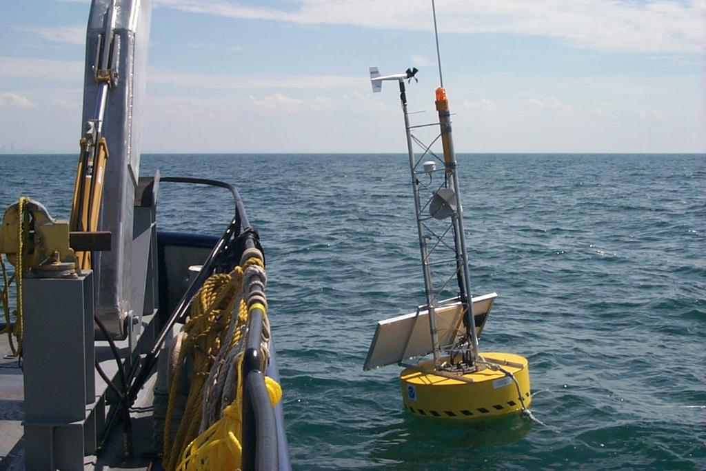
6 RECON Buoy Operation Buoy 3 Buoy 2 Buoy 1 Wind speed and direction, air temp Cleveland, OH 21 m Temp, Chlorophyl, Turbidity, Oxygen Profiles Hourly Continuous. Waves and Currents. Cholorophyl, Turbidity, Oxygen
7 System Block Diagram Buoy Platform Shore Station 2.4 GHz Wireless Ethernet Link Wireless Ethernet Link Firewall Router Local Trusted Network Linux: VPN + Firewall IPSec 168 bit encryption Local Firewall MET Sensors GPS CR200 Compass Buoy Port Server Ethernet Hub Internet U/W Cable GLERL Home Underwater Hub DMZ GLERL Firewall Trusted Underwater Hub Port Server Linux: VPN+Firewall Router SSH Data Processing & Archive ADCP CR200 Therm String PAR YSI Windows PC Web Server

8 Hub with Linux Buffer, Port Server, A/D Interfaces - guest port concept
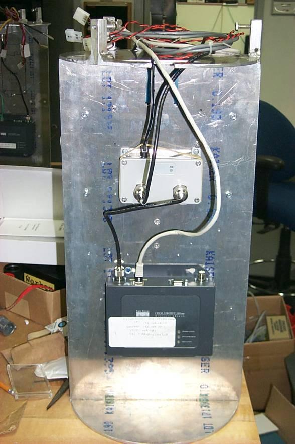
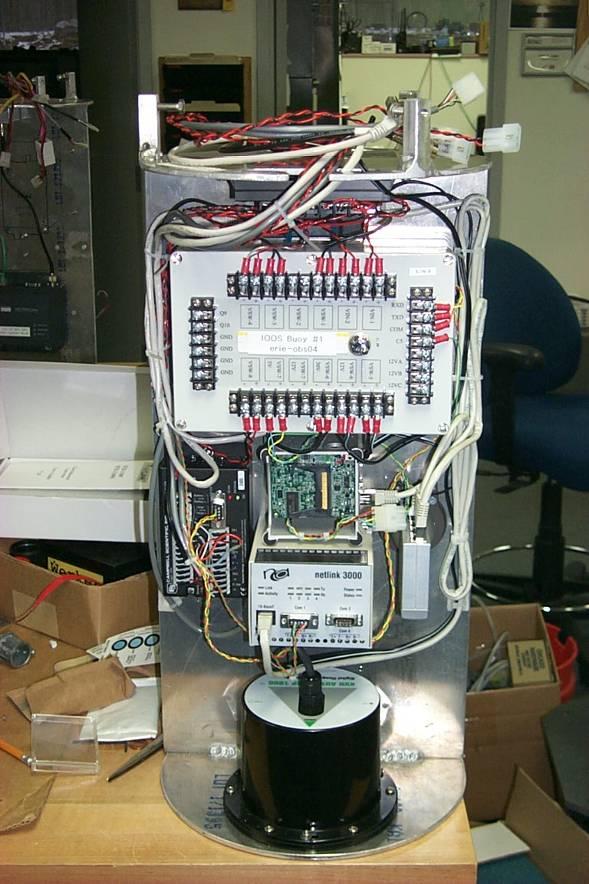
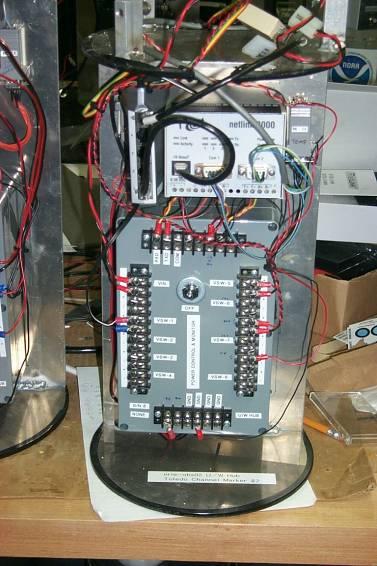
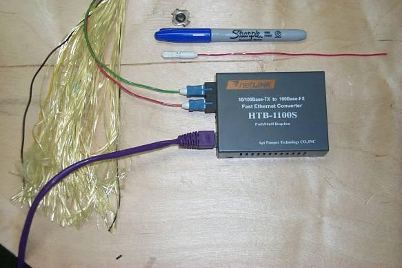
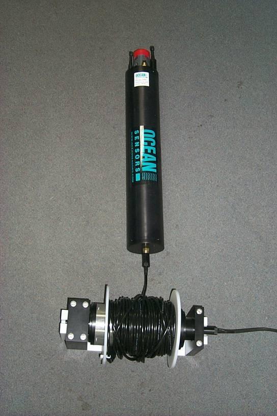
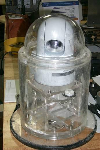
9 Network Components and Instrumentation Buoy Electronics Vertical Profiler UW Hub Webcam Fiber Optic Cable


 - Public Information (explanation of H 2 S odor")
10 RECON Locations and Applications Wireless systems deployed on Great Lakes coasts in collaboration with universities, Thunder Bay NMS, and NASA Applications in 2005,6: - Real-Time Fisheries Acoustics - NWS Marine Wave Forecast Verification in Convergence Zone - Beach Closure Forecast Model Development, NOAA Oceans and Human Health - Thunder Bay National Marine Sanctuary - Shipwreck Imagery, Met Data - Yellow Perch Recruitment Model Development - University Benthic and Fisheries Studies (UT, OSU) - Science Education (Monroe Public Schools hypoxia project) - Public Information (explanation of H 2 S odor associated with lake turnover in media)

11 Results to Date: - demonstrated the feasibility of wireless buoy data transfer in array and relay - maintains connection in high waves, heavy rain, snow - demonstrated ability to obtain high-bandwidth data and provide instrument control - demonstrated streaming video in educational live dives broadcasting environmental science and archeological outreach programs from 10 miles (at TBNMS) - developed a real-time web accessible data display In 2006,7: - develop real-time database management system with the Ohio State Supercomputing Center - complete integration of vertical profiling capability - continue development of fiber optic underwater hub interface - add under-ice observation capability Shore Station U. Toledo Light #2 Buoy 3 Buoy 1 Buoy 2 Shore Station NASA


12 Observations of Oxygen and Temperature 2005 Data 2003 Data Comparison of oxygen decline in Erie central basin. Thermocline in 2005 is slightly thicker and lower in temperature than 2003 results. Oxygen decline (less than 3mg/l) in 2005 occurs later in the year falling at a slower rate.

13 Lake Erie Mixing Event Lake mixing resulted in increased oxygen and bottom temperatures also associated with reported H 2 S odor along south shore of Lake Erie. Wind Speed Water Temperature Wave Height Air Temperature Oxygen at Bottom
14 Questions?
15 Questions?
16
17 Buoy General Specifications and Mooring Buoyancy: 545kg (1600lbs) Dia: 1.22 m (4ft) Ht: 0.61 m (2ft) 2 pt. Chain Mooring
18
19
20
21 Buoy and Fixed Observation Sites Bandwidth Capacity TBNMS 20 Mb/s 2 Mb/s UWM 2 Mb/s UT LEC 384 kb/s NASA


22 Networking Possibilities: Western Lake Eire IEEE b wireless hub configuration - Common gateway - Unique IP addresses LEC Shore Station - address translation

23 CISCO 350 Wireless Internet Radio - IEEE b Standard - Access Point capable of 2048 connections - Reliable range tested to date: 14 miles. Allows design of system based on currently available networking hardware and open source software - meets requirement for high-bandwidth, low-cost
A Wireless Internet-Based Observatory: The Real-time Coastal Observation Network (ReCON)
") A Wireless Internet-Based Observatory: The Real-time Coastal Observation Network (ReCON) S. A. Ruberg, R. W. Muzzi, S. B. Brandt, J. C. Lane, T. C. Miller National Oceanic and Atmospheric Administration
A Wireless Internet-Based Observatory: The Real-time Coastal Observation Network (ReCON) S. A. Ruberg, R. W. Muzzi, S. B. Brandt, J. C. Lane, T. C. Miller National Oceanic and Atmospheric Administration
Recent Developments in NOAA s Real- Time Coastal Observing Systems for Safe and Efficient Maritime Transportation
 Recent Developments in NOAA s Real- Time Coastal Observing Systems for Safe and Efficient Maritime Transportation Rich Edwing, Director NOAA Center for Operational Oceanographic Products and Services CMTS
Measuring Currents from Aids-to-Navigation Buoys
 Measuring Currents from Aids-to-Navigation Buoys Recent Design Improvements Bob Heitsenrether Kate Bosley, PhD Kasey Hall Overview CO-OPS Background NOAA s Physical Oceanographic Real-time System (PORTS
Xylem Analytics. Ocean & Coastal Monitoring Solutions
 Xylem Analytics Ocean & Coastal Monitoring Solutions Coastal Research Environmental Monitoring Ferrybox Aquaculture System Integration Recovery Marine Transport Offshore Installation Oceanography Oil &
UPDATE ON CHSD OBSERVING SYSTEM EFFORTS. Carl Friedrichs, Director of VIMS Coastal Hydrodynamics & Sediment Dynamics Lab
 UPDATE ON CHSD OBSERVING SYSTEM EFFORTS Carl Friedrichs, Director of VIMS Coastal Hydrodynamics & Sediment Dynamics Lab UPDATE ON CHSD OBSERVING SYSTEM EFFORTS 1. Projects & Proposals 2. Industry Partnerships
Programmatic Updates & Perspectives Julie Thomas Executive Director, SCCOOS
 Programmatic Updates & Perspectives Julie Thomas Executive Director, SCCOOS Board of Governors Meeting Hyperion Water Reclamation Plant Los Angeles December 3,2015 Southern California Coastal Ocean Observing
PRODUCTS AND SERVICES FOR THE MARITIME COMMUNITY. Ed Martin, Chief Customer Affairs Branch Navigation Services Division Monday, 27 October, 2008
 PRODUCTS AND SERVICES FOR THE MARITIME COMMUNITY Ed Martin, Chief Customer Affairs Branch Navigation Services Division Monday, 27 October, 2008 Coral Reef Conservation International Collaboration Marine
Pioneer Array Micro-siting Meeting
 Ocean Observatories Initiative Pioneer Array Micro-siting Meeting June 7, 2011 Coastal Institute University of Rhode Island June 7, 2011 PIONEER ARRAY MICRO-SITING MEETING AGENDA Welcome, Introduction
Ocean Observations Erik Buch EuroGOOS chair
 EB1 EB2 Ocean Observations Erik Buch EuroGOOS chair 15-07-2015 EuroGOOS AISBL eurogoos@eurogoos.eu - http://www.eurogoos.eu 1 Slide 1 EB1 Erik Buch, 2/26/2014 EB2 Erik Buch, 2/26/2014 Maritime activities
Robust, Reliable and Secure Marine Data
 Robust, Reliable and Secure Marine Data Charlotte O Kelly, CEO TechWorks Marine TechWorks Marine Pottery Enterprise Zone Pottery Road Dun Laoghaire Co. Dublin www.techworks.ie Acoustics Workshop, 7 th
The Alliance for Coastal Technologies
 The Alliance for Coastal Technologies Supporting the Technical Education & Training Needs of Tomorrow s Ocean Observing Workforce Ali L. Hudon ACT Gulf of Mexico Partner Education & Outreach Coordinator
Kendra Daly Director, ORION Program
 Kendra Daly Director, ORION Program Design & Implementation Workshop Salt Lake City, March 27-30 2006 Monday, 27 March Outline of Talks OOI/ORION and Goals of D&I Workshop Kendra Daly (ORION Program Director)
The present 5-year cycle of U.S. Argo implementation began in July 2015, and extends through June 2020.
 U.S. Argo National Report to AST-18, March 2017. Organization of U.S. Argo: The U.S. Argo Program is supported with major funding provided by the National Oceanic and Atmospheric Administration (NOAA),
Guide to Inductive Moorings
 Guide to Inductive Moorings Real-Time Ocean Observing Systems with Inductive Modem Telemetry Technology Visit Us at sea-birdscientific.com Reach us at info@seabird.com Copyright 2016 Sea-Bird Scientific
Mobile Platform Observations in the Gulf of Mexico
 Mobile Platform Observations in the Gulf of Mexico 1), Steven Meyers 2), Mark E. Luther 2) 1) Helmholtz Centre Geestacht, Institute of Coastal Research, Geesthacht, Germany 2) University of South Florida,
The VIMS mission is to achieve and maintain a national and international position as a premier coastal marine science institute. This involves making
 The VIMS Campus. The VIMS mission is to achieve and maintain a national and international position as a premier coastal marine science institute. This involves making seminal advances in knowledge and
25 CORE ASTRO FLEXIBLE, SCALABLE CONFIGURATIONS
 FLEXIBLE, SCALABLE CONFIGURATIONS ASTRO 25 CORE Small town or major city single department or multi-agency your radio system should fit your needs and your budget. Motorola s dynamic architecture gives
2. Measurement Range / Further specifications of the LOG_aLevel system
 1. Introduction General Acoustics, e.k., founded in 1996, with its origins as an acoustics and sensors research and services partnership, is now a high-end technology producer of sophisticated water level
SOLVED MEASUREMENT COMMUNICATION INSIGHT
 SEDIMENT? SOLVED MEASUREMENT COMMUNICATION INSIGHT CONTENTS Sediment? Solved. AQUAlogger 210TY SSC Converter The Acoustic Profiler AQUAscat 1000 range AQUAscat 1000R AQUAscat 1000S AQUAscat 1000LT AQUAscat
Abstract. 1. Introduction
 IBP1572_09 REMOTE EROSION AND CORROSION MONITORING OF SUBSEA PIPELINES USING ACOUSTIC TELEMETRY AND WET-MATE CONNECTOR TECHNOLOGY Howard Painter 1, Stewart Barlow 2, Daniel Clarke 3, Dale Green 4 Copyright
Rutter High Resolution Radar Solutions
 Rutter High Resolution Radar Solutions High Resolution Imagery, Target Detection, and Tracking At the core of our enhanced radar capabilities are proprietary radar processing and imaging technologies.
Mid-Frequency Noise Notch in Deep Water. W.S. Hodgkiss / W.A. Kuperman. June 1, 2012 May 31, 2013
 Mid-Frequency Noise Notch in Deep Water W.S. Hodgkiss and W.A. Kuperman June 1, 2012 May 31, 2013 A Proposal to ONR Code 322 Attn: Dr. Robert Headrick, Office of Naval Research BAA 12-001 UCSD 20123651
The Acoustic Oceanographic Buoy Telemetry System
 The Acoustic Oceanographic Buoy Telemetry System An advanced sonobuoy that meets acoustic rapid environmental assessment requirements {A. Silva, F. Zabel, C. Martins} In the past few years Rapid Environmental
David Franc. Department of Commerce Office of Radio Frequency Management
 David Franc Department of Commerce Office of Radio Frequency Management Oceanographic Radar Outline What It Does Some Examples What It Looks Like How It Works How Much It Costs Spectrum Considerations
High Speed E-Band Backhaul: Applications and Challenges
 High Speed E-Band Backhaul: Applications and Challenges Xiaojing Huang Principal Research Scientist and Communications Team Leader CSIRO, Australia ICC2014 Sydney Australia Page 2 Backhaul Challenge High
Connecting STEM and Environmental Education
 Connecting STEM and Environmental Education Mid-Atlantic Environmental Literacy Summit December 2, 2013 Louisa Koch NOAA Director of Education www.education.noaa.gov Louisa.Koch@NOAA.GOV 1 Outline NOAA,
System development and performance of the Deep-ocean Assessment and Reporting of Tsunamis (DART) system from
 system from") ITS 2001 Proceedings, NHTMP Review Session, Paper R-24 317 System development and performance of the Deep-ocean Assessment and Reporting of Tsunamis (DART) system from 1997 2001 Christian Meinig, Marie
ITS 2001 Proceedings, NHTMP Review Session, Paper R-24 317 System development and performance of the Deep-ocean Assessment and Reporting of Tsunamis (DART) system from 1997 2001 Christian Meinig, Marie
HiSeasNet: Internet on the High Seas for 6 years and counting
 HiSeasNet: Internet on the High Seas for 6 years and counting Inmartech 2008 Steve Foley Scripps Institution of Oceanography Overview HiSeasNet: The system What it is Coverage areas Equipment HiSeasNet:
Connecting the automated field Building blocks for the modern field network
 WELL SITE AUTOMATION, JANUARY 2017 Connecting the automated field Building blocks for the modern field network Renner Vaughn, Global Program Lead Show me the data! Great crew change continues That mindset
Lakewide Action and Management Plans - LAMPs Beth Hinchey Malloy & Liz LaPlante, US EPA GLNPO
 Lakewide Action and Management Plans - LAMPs Beth Hinchey Malloy & Liz LaPlante, US EPA GLNPO An Overview Prepared for GL ANS Panel Meeting Nov 7, 2018 Great Lakes Water Quality Purpose is to restore and
The Growing Offshore Wind Market: Massachusetts Example National Conference of State Legislatures
 The Growing Offshore Wind Market: Massachusetts Example National Conference of State Legislatures Nils Bolgen, Program Director Offshore Wind February 21, 2019 Topics Drivers for Offshore Wind Siting Market
Combining Active and Passive Acoustics to Study Marine Mammals
 Combining Active and Passive Acoustics to Study Marine Mammals Jennifer L. Miksis-Olds Applied Research Laboratory The Pennsylvania State University PO Box 30 State College, PA 16804 phone: (814) 865-9318
SEABED MAPPING IN THE NATIONAL MARINE SANCTUARIES. Bradley W. Barr, NOAA s National Marine Sanctuary Program. Abstract
 SEABED MAPPING IN THE NATIONAL MARINE SANCTUARIES Bradley W. Barr, NOAA s National Marine Sanctuary Program Abstract Seabed maps are an essential tool in the coastal and ocean resource manager s toolbox,
COASTAL MONITORING BUOY CMB 3280
 AANDERAA INSTRUMENTS DATA COLLECTING INSTRUMENTS FOR LAND SEA AND AIR COASTAL MONITORING BUOY CMB 3280 A moored data buoy for measuring - meteorological conditions - wave height and wave period - current
Exploring National Marine Sanctuaries
 Each student team researches and reports on one of the National Marine Sanctuaries and completes a thought-provoking worksheet to compare and contrast their sanctuary with the others. SUBJECTS Science,
Future of Sustained Observations
 Future of Sustained Observations OceanObs 09 identified tremendous opportunities, significant challenges Called for a framework for planning and moving forward with an enhanced global sustained ocean observing
Marine Weather Program
 Marine Weather Program Shipping Federation of Canada Marine Workshop 2018 Montreal daniel.huang@canada.ca Meteorological Service of Canada Jan 31, 2018 ECCC is actively adapting its marine weather observing
Transitioning Submersible Chemical Analyzer Technologies for Sustained, Autonomous Observations from Profiling Moorings, Gliders and other AUVs
 Transitioning Submersible Chemical Analyzer Technologies for Sustained, Autonomous Observations from Profiling Moorings, Gliders and other AUVs PI: Alfred K. Hanson SubChem Systems, Inc. 665 North Main
Satellite services and products for Automatic Weather Stations. Sophie Baudel
 Satellite services and products for Automatic Weather Stations Sophie Baudel sbaudel@cls.fr Share basic knowledge on telemetry services used by meteorologists and oceanographers for autonomous platforms
Assessing Tidal Energy Resource
 Assessing Tidal Energy Resource Frank Biskup, Bilbao Marine Energy Week, Bilbao 1 Tidal Farm 2 Tidal Site ADCP with 10 min average 3 Tidal Site ADCP with high resolution of 2 Hz 4 Tidal Site ADCP Measurement
Southeast O ahu (SEO) Regional Sediment Management (RSM) Workshop #2 June 1, 2005 Ko olau Golf Course
 Regional Sediment Management (RSM) Workshop #2 June 1, 2005 Ko olau Golf Course") Southeast O ahu (SEO) Regional Sediment Management (RSM) Workshop #2 June 1, 2005 Ko olau Golf Course 1 June 2005 Southeast O ahu RSM Workshop #2 1 Agenda Welcome and Introductions Mr. Sam Lemmo Summary
Southeast O ahu (SEO) Regional Sediment Management (RSM) Workshop #2 June 1, 2005 Ko olau Golf Course 1 June 2005 Southeast O ahu RSM Workshop #2 1 Agenda Welcome and Introductions Mr. Sam Lemmo Summary
BookletChart. Sacramento River Andrus Island to Sacramento NOAA Chart A reduced-scale NOAA nautical chart for small boaters
 BookletChart Sacramento River Andrus Island to Sacramento NOAA Chart 18662 A reduced-scale NOAA nautical chart for small boaters When possible, use the full-size NOAA chart for navigation. Included Area
4G system for internet access in coastal areas
 4G system for internet access in coastal areas System Presentation The purpose of NeptuLink by MVG is to satisfy the broadband IP communication needs of users on board ships and various vessels in coastal
EIS - Electronics Instrumentation Systems for Marine Applications
 Coordinating unit: Teaching unit: Academic year: Degree: ECTS credits: 2015 230 - ETSETB - Barcelona School of Telecommunications Engineering 710 - EEL - Department of Electronic Engineering MASTER'S DEGREE
James Bellingham. Marine Robotics
 James Bellingham Marine Robotics Robotic systems are transforming the ocean sciences. Marine Robotics - Teleoperation In the 1990s, WHOI was one of a few organizations with deep-diving Remotely Operated
idocent: Indoor Digital Orientation Communication and Enabling Navigational Technology
 idocent: Indoor Digital Orientation Communication and Enabling Navigational Technology Final Proposal Team #2 Gordie Stein Matt Gottshall Jacob Donofrio Andrew Kling Facilitator: Michael Shanblatt Sponsor:
South Coast Marine Cluster. World Leading Innovation-led Marine & Maritime Cluster
 South Coast Marine Cluster World Leading Innovation-led Marine & Maritime Cluster The South Coast Marine Cluster Concept Began as a cross- local authority and LEP partnership initiative through the GREAT
TECHNICAL INFORMATION GUIDE. Alcatel MDR-9000s-155 High Capacity/High Frequency SONET Microwave Radio
 TECHNICAL INFORMATION GUIDE Alcatel MDR-9000s-155 High Capacity/High Frequency SONET Microwave Radio Introduction The Alcatel MDR-9000s-155 is the latest addition to Alcatel s industry leading wireless
ACOUSTIC RESEARCH FOR PORT PROTECTION AT THE STEVENS MARITIME SECURITY LABORATORY
 ACOUSTIC RESEARCH FOR PORT PROTECTION AT THE STEVENS MARITIME SECURITY LABORATORY Alexander Sutin, Barry Bunin Stevens Institute of Technology, Castle Point on Hudson, Hoboken, NJ 07030, United States
Data Buoy Achievements
 Data Buoy Achievements 370, rue Jean de Guiramand 13792 Aix en Provence Cedex 3 Tél: +33 (0) 4 42 37 15 00 Fax: +33 (0) 4 42 37 15 01 Mail: mobilis@mobilis-sa.com Site: www.mobilis-sa.com Introduction
Marine Monitor (M ) A Low Cost Radar Solution for Monitoring Nearshore Marine Protected Areas
 A Low Cost Radar Solution for Monitoring Nearshore Marine Protected Areas") 2 Marine Monitor (M ) A Low Cost Radar Solution for Monitoring Nearshore Marine Protected Areas 1 Problem The number of Marine Protected Areas (MPAs) are increasing globally making it challenging to effectively
2 Marine Monitor (M ) A Low Cost Radar Solution for Monitoring Nearshore Marine Protected Areas 1 Problem The number of Marine Protected Areas (MPAs) are increasing globally making it challenging to effectively
ONGOING AND FUTURE PROJECTS
 (Kamgar-Parsi 92). (Karahalios 91) examines volumetric sonar visualization concepts and presents example visualizations using near-field sonar processing data. Additional images from her work appear in
ITU/WMO Seminar Use of Radio Spectrum for Meteorology: Weather, Water and Climate Monitoring and Prediction
 ITU/WMO Seminar Use of Radio Spectrum for Meteorology: Weather, Water and Climate Monitoring and Prediction Session 5: Meteorological Aids Service (Radiosondes( Radiosondes) ) and Other Systems 5.1.1 MetAids)
Real-Time Current Measurements Improve Vessel Safety and Port Efficiency
 REPRINT Real-Time Current Measurements Improve Vessel Safety and Port Efficiency The ATON System Provides Port Decision Makers With a Reliable and Cost-Effective Alternative in Real-Time Current Monitoring
Multispectral Scanners for Wildland Fire Assessment NASA Ames Research Center Earth Science Division. Bruce Coffland U.C.
 Multispectral Scanners for Wildland Fire Assessment NASA Earth Science Division Bruce Coffland U.C. Santa Cruz Slide Fire Burn Area (MASTER/B200) R 2.2um G 0.87um B 0.65um Airborne Science & Technology
How Automatic Identification System (AIS) Is Being Used to Improve Navigation Safety Lock Operations Management Application Michael Winkler
 Is Being Used to Improve Navigation Safety Lock Operations Management Application Michael Winkler") How Automatic Identification System (AIS) Is Being Used to Improve Navigation Safety Lock Operations Management Application Michael Winkler June 2016 LOMA system overview USCG AIS data capabilities: AIS
How Automatic Identification System (AIS) Is Being Used to Improve Navigation Safety Lock Operations Management Application Michael Winkler June 2016 LOMA system overview USCG AIS data capabilities: AIS
GULF OF THE FARALLONES NATIONAL MARINE SANCTUARY
 GULF OF THE FARALLONES NATIONAL MARINE SANCTUARY FINAL MANAGEMENT PLAN PREPARED AS PART OF THE JOINT MANAGEMENT PLAN REVIEW (JMPR) VOLUME II OF IV OCTOBER 2008 U.S. DEPARTMENT OF COMMERCE NATIONAL OCEANIC
University of North Florida
 Water Quality Buoy Michael Toth, Patrick Welsh and J. David Lambert Environmental Monitoring Mapping Analysis and Planning Systems Laboratory ONR Buoy Conference Monterey, CA March 9-11, 2010 Buoy Design
An abridged history of ALPS. Dan Rudnick Scripps Institution of Oceanography
 An abridged history of ALPS Dan Rudnick Scripps Institution of Oceanography Why ALPS? Autonomous and Lagrangian Platforms and Sensors The fundamental observational problem in oceanography is that of sampling
Using new monitoring and control technology to advance safety and asset integrity in the oilfield
 Lloyd s Register Energy Conference Safety-driven performance 2012 Using new monitoring and control technology to advance safety and asset integrity in the oilfield Chris Tolleson Systems and Controls Chief
Recommendations from the High-Resolution Marine Meteorology Workshop
 Recommendations from the High-Resolution Marine Meteorology Workshop 3-5 March 2003 Center for Ocean-Atmospheric Prediction Studies Florida State University Tallahassee, FL USA Foreword A new initiative
Galileo signal reflections used for monitoring waves and weather at sea
 Press Release Monday 26 th November 2007 Galileo signal reflections used for monitoring waves and weather at sea Surrey Satellite Technology Ltd (SSTL) and the University of Surrey have succeeded for the
TECHNICAL SPECIFICATIONS GAP-FREE SECURITY. MeshConnex on both data radios ELIMINATE RADAR INTERFERENCE WITH SCAN AHEAD RADIO
 WLAN. GAP-FREE SECURITY The AP 8163 secures all your wireless transmissions, ensuring compliance with government and industry regulations, such as PCI in retail and HIPAA in healthcare. Your network is
Remote Sensing Aircraft Supports Disaster Response
 Remote Sensing Aircraft Supports Disaster Response Mark Foster Computer Sciences Corp. NASA Ames Research Center CENIC 2008 - March 10-12, 2008 CENIC 08: Lightpath to the Stars 1 Outline Disaster Scenarios
GNSS (GPS) buoy array in the Pacific for natural disaster mitigation. Teruyuki KATO Earthquake Research Institute the University of Tokyo, Japan
 buoy array in the Pacific for natural disaster mitigation. Teruyuki KATO Earthquake Research Institute the University of Tokyo, Japan") GNSS (GPS) buoy array in the Pacific for natural disaster mitigation Teruyuki KATO Earthquake Research Institute the University of Tokyo, Japan 1 (Modified from Oki & Koketsu, 2011) Historical megaquakes
GNSS (GPS) buoy array in the Pacific for natural disaster mitigation Teruyuki KATO Earthquake Research Institute the University of Tokyo, Japan 1 (Modified from Oki & Koketsu, 2011) Historical megaquakes
Outreach Strategy to Reduce Damage to Ocean Data Buoys From Vandalism
 Outreach Strategy to Reduce Damage to Ocean Data Buoys From Vandalism August 2017 Preface On June 7, 2016, the Intergovernmental Oceanographic Commission (IOC) and the World Meteorological Organization
HF Radar Measurements of Ocean Surface Currents and Winds
 HF Radar Measurements of Ocean Surface Currents and Winds John F. Vesecky Electrical Engineering Department, University of California at Santa Cruz 221 Baskin Engineering, 1156 High Street, Santa Cruz
Subsea UK Neil Gordon Chief Executive Officer Championing the UK Subsea Sector Across the World
 Subsea UK Neil Gordon Chief Executive Officer Championing the UK Subsea Sector Across the World 1 Overview About Subsea UK Facts and figures UK industry evolution Centre of Excellence Technology and Innovation
A short review of Mexican Observing Systems
 A short review of Mexican Observing Systems THe Observing system Research and Predictability EXperiment Fernando Oropeza Rosales North American THORPEX meeting México City April 12th-13th, 2007 Objetives
Long Range Acoustic Communications Experiment 2010
 Long Range Acoustic Communications Experiment 2010 Marine Physical Laboratory Scripps Institution of Oceanography La Jolla, CA 92093-0701 6 September 2010 Objectives Experimentally confirm that robust
HICO Status and Operations
 HICO Status and Operations HICO Users Group 7-8 May 2014 Mary Kappus, HICO Facility Manager Naval Research Laboratory Washington, DC HICO Transition to NASA Tech Demo Phase 1 In September 2009 HICO began
Development of Mid-Frequency Multibeam Sonar for Fisheries Applications
 Development of Mid-Frequency Multibeam Sonar for Fisheries Applications John K. Horne University of Washington, School of Aquatic and Fishery Sciences Box 355020 Seattle, WA 98195 phone: (206) 221-6890
HyperLink Wireless Low PIM DAS 2x2 MIMO Ceiling Antenna Model: HG72706DPCUPR-NF
 HyperLink Wireless Low PIM DAS 2x2 MIMO Ceiling Antenna Model: HG72706DPCUPR-NF Applications DAS (Distributed Antenna Systems) 700 MHz and cellular applications AWS (Advanced wireless services) and PCS
December 12, Dear NOAA Family,
 December 12, 2012 Dear NOAA Family, I write to let you know that I have decided to return to my family and academia at the end of February. I am immensely proud of all we have accomplished in the last
Data Buoys. Supplying Testing & Monitoring Instruments Since 1946
 Data Buoys Supplying Testing & Monitoring Instruments Since 1946 CB-450 Self-powered data logging buoy Wi-Fi, radio, cellular or satellite telemetry Supports a variety of environmental sensors Accommodates
LBL POSITIONING AND COMMUNICATION SYSTEMS PRODUCT INFORMATION GUIDE
 LBL POSITIONING AND COMMUNICATION SYSTEMS PRODUCT INFORMATION GUIDE EvoLogics S2C LBL Underwater Positioning and Communication Systems EvoLogics LBL systems bring the benefi ts of long baseline (LBL) acoustic
BookletChart. Intracoastal Waterway Grassy Key to Bahia Honda Key NOAA Chart A reduced-scale NOAA nautical chart for small boaters
 BookletChart Intracoastal Waterway Grassy Key to Bahia Honda Key NOAA Chart 11453 A reduced-scale NOAA nautical chart for small boaters When possible, use the full-size NOAA chart for navigation. Published
Realtime Airborne Imagery for Emergency GIS Applications
 Realtime Airborne Imagery for Emergency GIS Applications Demonstration and Evaluation with Monroe County Office of Emergency Management August - September 2010 Information Products Laboratory for Emergency
NetPoint Pro. 6x2.4, 6x5.8, 3x2.4, 3x5.8. Wi-Fi base Stations Providing Superior Connectivity
 NetPoint Pro 6x2.4, 6x5.8, 3x2.4, 3x5.8 Wi-Fi base Stations Providing Superior Connectivity NetPoint Pro is an advanced Wi-Fi base station that provides superior connectivity and greater range. It enables
CODAR. Ben Kravitz September 29, 2009
 CODAR Ben Kravitz September 29, 2009 Outline What is CODAR? Doppler shift Bragg scatter How CODAR works What CODAR can tell us What is CODAR? Coastal Ocean Dynamics Application Radar Land-based HF radar
Progress in Refreshing the Tropical Atmosphere Ocean (TAO) Array
 Array") Progress in Refreshing the Tropical Atmosphere Ocean (TAO) Array Richard L. Crout, PhD, Dawn Petraitis, Lex LeBlanc, Landry J. Bernard, and Karen Grissom NOAA/NWS National Data Buoy Center Stennis Space
Progress in Refreshing the Tropical Atmosphere Ocean (TAO) Array Richard L. Crout, PhD, Dawn Petraitis, Lex LeBlanc, Landry J. Bernard, and Karen Grissom NOAA/NWS National Data Buoy Center Stennis Space
OUR VISION FOR AMERICA S TREASURED OCEAN PLACES
 OUR VISION FOR AMERICA S TREASURED OCEAN PLACES A Five-Year Strategy for the National Marine Sanctuary System DRAFT For Advisory Council Chairs Webinar September 19, 2016 This document is an internal draft
Research Vessel Technical Enhancement Committee (RVTEC) November 2009 Meeting ISS - Integrated Survey Systems
 November 2009 Meeting ISS - Integrated Survey Systems") Research Vessel Technical Enhancement Committee (RVTEC) November 2009 Meeting ISS - Integrated Survey Systems John Kiernan, P.E. SAIC - Marine Science and Technology Division ISS-2000 Integrated Survey
Research Vessel Technical Enhancement Committee (RVTEC) November 2009 Meeting ISS - Integrated Survey Systems John Kiernan, P.E. SAIC - Marine Science and Technology Division ISS-2000 Integrated Survey
Wireless Temperature Sensor with Probe
 The Leader in Low-Cost, Remote Monitoring Solutions Wireless Temperature Sensor with Probe TEMPERATURE 3 FOOT PROBE General Description The Wireless Temperature Sensor with Probe uses a type NTC thermistor
Japanese Argo Program
 PICES XV Oct15, 2006 Japanese Argo Program Nobie Shikama (JAMSTEC) What is Argo? Argo is a global ocean monitoring network of 3,000 floats which measure T-S profile of upper 2,000m every 10 days and transmit
Wireless Temperature Sensor
 The Leader in Low-Cost, Remote Monitoring Solutions Wireless Temperature Sensor General Description The Wireless Temperature Sensor uses a type NTC thermistor to measure temperature. Features Accurate
BookletChart. St. Joseph and Benton Harbor NOAA Chart A reduced-scale NOAA nautical chart for small boaters
 BookletChart St. Joseph and Benton Harbor NOAA Chart 14930 A reduced-scale NOAA nautical chart for small boaters When possible, use the full-size NOAA chart for navigation. Included Area Published by the
Wireless Magnet Detection Sensor
 The Leader in Low-Cost, Remote Monitoring Solutions Wireless Detection Sensor MAGNET DETECTION General Description The Wireless Detection Sensor can be used to detect the presence of a magnetic source
Establishing Newport, Oregon as a Hub for Ocean Observing Activities in the Pacific Northwest. A Strategic Framework
 Establishing Newport, Oregon as a Hub for Ocean Observing Activities in the Pacific Northwest A Strategic Framework Prepared for the: Yaquina Bay Economic Foundation (YBEF) By: With funding from: Oregon
Cisco s CLEC Networkers Power Session
 Course Number Presentation_ID 1 Cisco s CLEC Networkers Power Session Session 2 The Business Case for ONS 15800 3 What s Driving the Demand? Data Voice 4 What s Driving the Demand? Internet 36,700,000
CO-OPS Current Sensors Data Telemetry and Formatting
 CO-OPS Current Sensors Data Telemetry and Formatting NOAA/NOS Center for Operational Oceanographic Products and Services User Report IHO Currents Working Group June, 2014 Program Elements 2 Physical Oceanographic
Dynamic Ambient Noise Model Comparison with Point Sur, California, In-Situ Data
 1 Dynamic Ambient Noise Model Comparison with Point Sur, California, In-Situ Data Charlotte V. Leigh, APL-UW Anthony I. Eller, SAIC Applied Physics Laboratory, University of Washington Seattle, Washington
Science Integration Fellowship: California Ocean Science Trust & Humboldt State University
 Science Integration Fellowship: California Ocean Science Trust & Humboldt State University SYNOPSIS California Ocean Science Trust (www.oceansciencetrust.org) and Humboldt State University (HSU) are pleased
Department of Energy s Legacy Management Program Development
 Department of Energy s Legacy Management Program Development Jeffrey J. Short, Office of Policy and Site Transition The U.S. Department of Energy (DOE) will conduct LTS&M (LTS&M) responsibilities at over
taking the next generation of explorers to the heart & soul of Science itself.
 taking the next generation of explorers to the heart & soul of Science itself. A LEGACY OF EXPERIENTIAL SCIENCE The first scientists didn t work in a lab. They worked in the real world. Climbing mountains
The Marine Managed Areas Inventory of the United States
 The Marine Managed Areas Inventory of the United States The National Marine Protected Areas Center Dan Farrow, MMA Inventory Coordinator Wednesday, June 25, 2003 Overview MMA Inventory Basics Status of
Technical Datasheet GT-8550B Series USB Power Sensor 10 MHz to 26.5 GHz
 Technical Datasheet GT-8550B Series USB Power Sensor 10 MHz to 26.5 GHz PC-based Power Meter 35424-Rev.A/ US122112 GT-8550B Series USB Power Sensors GT-8550B Series USB Peak Power Sensors Advanced Power
Acoustic Communications and Navigation for Mobile Under-Ice Sensors
 DISTRIBUTION STATEMENT A. Approved for public release; distribution is unlimited. Acoustic Communications and Navigation for Mobile Under-Ice Sensors Lee Freitag Applied Ocean Physics and Engineering 266
Northeast Florida Coastal Wetland Restoration Program A Partnership Based Regional Approach for Estuary Habitat Restoration
 Northeast Florida Coastal Wetland Restoration Program A Partnership Based Regional Approach for Estuary Habitat Restoration Paul Haydt Restore America s Estuaries November 15, 2010 St Johns River Water
Involving Citizens in the Identification, Development and Use of Research Infrastructures
 Involving Citizens in the Identification, Development and Use of Research Infrastructures Sara Iverson Scientific Director, Ocean Tracking Network Involving Citizens in the Identification, Development