The human touch in technology. ECDIS ECS Conning screen Ship speed info system
|
|
|
- Aron Owen
- 5 years ago
- Views:
Transcription

1 The human touch in technology ECDIS ECS Conning screen Ship speed info system


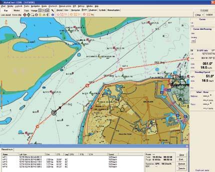
2 Alphatron ALPHACHART T ECDIS Type approved ECDIS system powered by TRANSAS The ALPHACHART T is an advanced Electronic Chart Display Information System powered by Transas and the easiest to operate. Having evolved in 1999 from the first ECDIS worldwide to hold a type approval certificate, it is the result of Transas long standing experience in the field of marine navigation and is capable of meeting the demands and requirements of the professional navigator. ALPHACHART T ECDIS can be used both as a stand-alone system and as part of an Integrated Bridge System and now comes with the latest standard capabilities. The system can be installed on newly built ships, or existing vessels can be retrofitted with the ECDIS system. A dual ECDIS system may legally replace paper charts on board. The system is able to use IC-ENC, primar and UKHO s ARCS raster charts as well as other S-57 vector cartography. A non-type approved ECS version is available under the name ALPHACHART COASTER T. MAIN FEATURES Safe Navigation and Easy Operation Always about safety, ALPHACHART T ECDIS excels at giving you all the information you need when you need it, via the user-friendly menu system helping you to use the system intuitively. Savings Direct effect on fuel consumption, voyage times & work time. Planning and Forecasting Powerful tools for passage planning, weather routing and calculation and environmental tide and current databases. Weather forecast with the optional SPOS weather and route planning tool, are integrated. Choice and Customization New and practical options enable you to customize the system to meet your needs including multiple operation modes with charts in up to 7 different formats and a full keyboard roller ball option. Sensor Integration Connects all available onboard navigation data sensors and systems, such as: two positioning systems, gyro, log, two ARPA s, AIS echo sounder, autopilot NavTex and many more. Information system and Decision Support A Continual flow of information for presentation of the crucial and most needed navigational information and objects, keeps you informed of any situation. Playback Functions The following playback options are available: Playback of the recorded own ship track and motion parameters Playback of the recorded targets tracks received from the ARPA and AIS 12 hours log acc requirements The colours and pictures in this brochure can deviate from reality.
3 NavTex Manager ALPHACHART T automatically reads off message supplied by the Navtex system, processes them and then integrates them into the Electronic Chart, displaying all the information with necessary zone and message mark alarms. SPOS WEATHER MODULE The new convenient onboard SPOS weather and weather route planning tool enables users to receive weather forecasts supplied by Meteo Consult via daily. The SPOS permits: To receive up to 9-days forecasts with the world-wide coverage To subscribe, receive and display the forecasts twice a day To calculate various routes taking into account the weather conditions To create optimal routes and export them back to NaviSailor ECDIS To compare the routes results To save the best route as Voyage Plan and update daily if required SPOS has been designed to minimize operational costs. It provides detailed weather information onboard and supports the vessels staff during the planning and execution of the passages. ALPHACHART Radar Overlay ALPHACHART can incorporate the Transas radar processor board, which receives a signal from the radar, subjects the received signal to digital processing and forms a data array for overlaying a radar picture on the electronic chart. SEETRAC INTERFACE Seetrac integrated module tracks the position of each tender, jet ski and wet bike operating around the host yacht in ALPHACHART T ECDIS Data transmitted through the air from the tender gives tender position, speed, course, and optionally depth, wind and MOB alert The range of operation is typically 5-10 NM, depending on antenna heights. Frequency is UHF/VHF and output 5W
4 Track Control System In combination with the versatile Alphatron ALPHASEAPILOT MFA a type approved track control system is available. Operation could be done via the autopilot control unit or optionally via a unique LAN interface. Better Than Ever Positioning Information ALPHACHART T automatically provides the navigator with all the necessary information: Current ship position and motion vector s Fallback modes through various positioning systems and methods Reception of information from the radar/arpa and AIS for handling of targets Data obtained from other connected navigational sensors Display of the ship contour as per the set parameters and chart scale Transas Electronic Chart Solutions Transas provides the one-stop shop chart solutions, offering a complete range of official and non-offical charts. Transas is an official distributor of S-57 charts and charts in SECC format (System Electronic Navigation Charts) from the world main ENC providers: IC-ENC, Primar Stravange and NOAA. Transas SEC Distribution Service was fully tested and approved by DET Norske Veritas (DNV) in June Transas TX-97 electronic chart collection consists of more than 12,000 charts providing the world wide coverage for the navigator and is updated with the Notices to Mariners issued by the Hydrographic Organisation of different countries. To update TX-97 and SENC vector electronic charts, it is possible to use Transas unique Chart Assistant (CA) utility. The first of it s kind in the industry, the Chart Assistant (CA) utility. The first of it s kind in the industry, the Chart Assistant utility can use a variety of media to order or update your charts in TX-97 or SECC format: CD- quarterly delivery of an updated chart collection USB Flash updates are downloaded manually from official web-site ordering and updating charts form Transas Chart Server automatically online Transas provides an online maintenance service for charts in TX-97 and SEC formats. Charts in S-57/ENC, SEA- FARER ARCS, BSB/NDI, NOS/GEO formats could be installed and updated from CD or other removable data storage.
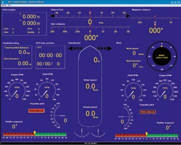
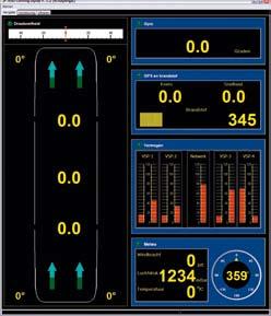
5 ALPHACHART RIVER Alphatron ALPHACON conning information system ALPHACON system, a fully customised conning information system. Available stand alone or fully integrated with ALPHASPEED and the ALPHACHART systems. Satellite based speed information system for speed fore, aft and along ship. Derived from dual satellite antenna one on the fore and one on the aft ship.
6 Alphatron Marine B.V. Harbour 115 Schaardijk NH Rotterdam The Netherlands T +31 (0) F +31 (0) P.O. Box AA Rotterdam deepsea@alphatronmarine.com
E C D I S E LECTRONIC C HART D ISPLAY I NFORMATION S YSTEM
 e l e c t r o n i c c h a r t d i s p l a y i n f o r m a t i o n s y s t e m T R A N S A S E C D I S T R A N S A S E C D I S 3 E C D I S is a computer-based navigation information system that complies
COMMAND-DEQ IBS Integrated Bridge System
 COMMAND-DEQ IBS Integrated Bridge System Page : 1 / 15 NAVIGATION BRIDGE 1 Navigation System 1.1 General The total Navigation System is based on «IBS» concept (Integrated Bridge System) The navigation
ECDIS and MANTADIGITAL. PLUS
 TM MANTADIGITAL ECDIS and PLUS 2011/2012 www.ecdisplus.com Introduction What is an ECDIS? ECDIS is an acronym for Electronic Chart Display and Information System. At its simplest, an ECDIS consists of
The human touch in technology. Maintenance free Fiber Optic Gyro compass ALPHAFIBERCOURSE
 The human touch in technology Maintenance free Fiber Optic Gyro compass ALPHAFIBERCOURSE ALPHAFIBERCOURSE GYRO COMPASS STATE OF THE ART FOG (FIBER OPTIC) STRAPDOWN TECHNOLOGY HEADING, ROLL, PITCH AND RATE
Is the new technology safe for navigation in coastal waters and archipelagos?
 3.35.20 Is the new technology safe for navigation in coastal waters and archipelagos? As near misses not are reported we take a look at the groundings Combat boat CB 90 (mostly) Thank you Lars-Erik! ECS
dkart Navigator 9010
 dkart Navigator 9010 dkart Navigator - purpose dkart Navigator is an electronic navigation chart system specially designed to facilitate all the navigational tasks of mariner's day-to-day practice. Along
IIMS TRAINING SEMINAR
 Title slide Identifying electronic equipment on today s advanced yachts? NAVIGATION EQUIPMENT non type approved 1 x Raymarine GPS ant/head 1 x Raymarine Fluxgate Compass 1 x Raymarine ST60 instruments
Model FAR-2xx8 Model FAR-3xx0
 Model FAR-2xx8 Model FAR-3xx0 Administrerende direktør Trond Strømmen Roy Fjeldstad Area Sales Manager Advanced technologies for safe navigation The FAR-2xx8 series is a new radar series; the successor
NHC 59th meeting Agenda item NHC59-9A April 14-15, 2015 Reykjavik - Iceland. New national ENC service for leisure craft users
 NHC 59th meeting Agenda item NHC59-9A April 14-15, 2015 Reykjavik - Iceland New national ENC service for leisure craft users The aim of the new ENC service The aim of the new ENC service is to enhance
Appendix: References and glossary
 Appendix: References and glossary Facts about electronic charts and carriage requirements 2nd edition 2007 V/1 CONTENTS OF SECTION 5 Appendix: References and glossary References...................................................
Nordic Hydrographic Commission 60th Conference - Stavanger - Norway April New national ENC service for leisure craft users
 Nordic Hydrographic Commission 60th Conference - Stavanger - Norway 11-13 April 2016 New national ENC service for leisure craft users New national ENC service for leisure craft users The aim of the new
The Pros and Cons of using ECDIS as Primary Means of Navigation
 Sections 1 2 Company introduction The PROS of Using ECDIS and ENCs 3 The CONS of Using ECDIS and ENCs 4 Why we have choose NAVTOR Company Introduction Corporate Overview. is a Ship Management Company established
INTERNATIONAL STANDARD
 INTERNATIONAL STANDARD IEC 61174 Second edition 2001-10 Maritime navigation and radiocommunication equipment and systems Electronic chart display and information system (ECDIS) Operational and performance
TRANSAS AIS NETWORK VIEWER
 TRANSAS AIS NETWORK VIEWER TRANSAS AIS NETWORK VIEWER (TRAN VIEWER) The Transas AIS Network (TrAN) Viewer software is intended for the reception, display, recording and analysis of data from different
GUIDELINES ON THE DESIGN AND USE OF PORTABLE PILOT UNITS INTERNATIONAL MARITIME PILOTS ASSOCIATION
 GUIDELINES ON THE DESIGN AND USE OF PORTABLE PILOT UNITS INTERNATIONAL MARITIME PILOTS ASSOCIATION WITH TECHNICAL INPUT FROM Comité International Radio-Maritime (CIRM) 2 FOREWORD With the increasing use
Transas 4000 Display series Navi-Sailor 4000 ECDIS MFD Navi-Radar 4000 MFD Navi-Conning 4000 Navi-AMS 4000
 Transas 4000 Multifunction isplay series Navi-Sailor 4000 ECIS MF Navi-Radar 4000 MF Navi-Conning 4000 Navi-AMS 4000 Transas 4000 MF series Transas 4000 Multifunction isplay System (MF) is a flexible and
INTEGRATED NAVIGATION SYSTEMS
 INTEGRATED NAVIGATION SYSTEMS Basic terms *integrated navigation system *control system *propulsion system *cargo system *digital processing unit *sensor *electronic circuits *sensor output *pulsed input
THE ELECTRONIC CHART DISPLAY AND INFORMATION SYSTEM (ECDIS) IN CHINA
 IN CHINA") International Hydrographic 'Review, Monaco, LXIX(2), September 1992 THE ELECTRONIC CHART DISPLAY AND INFORMATION SYSTEM (ECDIS) IN CHINA by The Research Group on ECDIS 1 Abstract This paper presents a
International Hydrographic 'Review, Monaco, LXIX(2), September 1992 THE ELECTRONIC CHART DISPLAY AND INFORMATION SYSTEM (ECDIS) IN CHINA by The Research Group on ECDIS 1 Abstract This paper presents a
Transport System. Telematics. Possibility of integration of navigational information on electronic chart
 Archives of Volume 3 Transport System Issue 2 Telematics May 2010 Possibility of integration of navigational information on electronic chart H. ŚNIEGOCKI a, M. WIELIKI b a Faculty of Navigation, Gdynia
AIS Training. AIS Technology in Digital Yacht Products Explained. Digital Yacht Ltd TEL
 AIS Training AIS Technology in Digital Yacht Products Explained Digital Yacht Ltd www.digitalyacht.co.uk TEL + 44 1179 554474 What is AIS? The Automatic Identification System (AIS) is the biggest advance
A Survey of Mariners' Opinions on Using Electronic Charts
 s i l s Note A Survey of Mariners' Opinions on Using Electronic Charts Igor Karnicnik, M.Sc., Geodetic Institute of Slovenia, Slovenia. A new component of modern shipborne navigation equipment is the Electronic
UPDATING THE ELECTRONIC CHART THE SEATRANS PROJECT
 International Hydrographic Review, Monaco, LXV II(2), July 1990 UPDATING THE ELECTRONIC CHART THE SEATRANS PROJECT by Robert SANDVIK (*) Abstract As a follow-up of the North Sea Project, which called for
DYNAMIC POSITIONING SIMULATORS
 MARITIME SIMULATION SOLUTIONS DYNAMIC POSITIONING SIMULATORS www.nautissim.com info@nautissim.com NAUTIS - MARITIME SIMULATION SOLUTIONS BY VSTEP VSTEP s NAUTIS Simulators are DNV certified integrated
Paper for Consideration by S-100WG3. Report on S-100 Sea trial of KHOA
 S-100WG3-8.1 Paper for Consideration by S-100WG3 Report on S-100 Sea trial of KHOA Submitted by: Executive Summary: Related Documents: Related Projects: Republic of Korea (KHOA) This paper reports the
ECDIS ENC Accuracy. Contents. Introduction LOSS PREVENTION BRIEFING FOR NORTH MEMBER SHIPS / MAY Introduction... 1
 LOSS PREVENTION BRIEFING FOR NORTH MEMBER SHIPS / MAY 2017 ECDIS ENC Accuracy Contents Introduction... 1 ECDIS Specific Familiarisation... 2 IHO S-57... 2 ENC Data Source... 2 CATZOC and M_QUAL... 2 CATZOC
Technology evolution for future radiocommunication and navigation
 Technology evolution for future radiocommunication and navigation Frances Baskerville (Secretary General) Richard Doherty (Deputy Secretary General) CIRM Who we are and what we do What is CIRM? The Worldwide
NOAA s National Ocean Service / Office of Coast Survey
 Coast Survey OCS 1807 2007 Maintains over 1000 nautical charts & 9 Coast Pilots Surveys over 3.4M SNM of oceans and lakes Conducts research and development in hydrography Thomas Jefferson Founder of The
FOREWORD. IHO S-100 Working Group
 IHO International Hydrographic Organization KHOA Korea Hydrographic and Oceanographic Agency MUCH MORE THAN JUST NAUTICAL CHARTS IHO UNIVERSAL HYDROGRAPHIC data MODEL This document was produced with the
MARITIME SIMULATION SOLUTIONS SIMULATOR OVERVIEW
 MARITIME SIMULATION SOLUTIONS SIMULATOR OVERVIEW www.nautissim.com info@nautissim.com NAUTIS - MARITIME SIMULATION SOLUTIONS BY VSTEP NAUTIS Simulators are DNV certified integrated simulator solutions
PRODUCTS AND SERVICES FOR THE MARITIME COMMUNITY. Ed Martin, Chief Customer Affairs Branch Navigation Services Division Monday, 27 October, 2008
 PRODUCTS AND SERVICES FOR THE MARITIME COMMUNITY Ed Martin, Chief Customer Affairs Branch Navigation Services Division Monday, 27 October, 2008 Coral Reef Conservation International Collaboration Marine
11 th CHRIS MEETING IHB, Monaco, November Draft - - -
 CHRIS/11/16A 11 th CHRIS MEETING IHB, Monaco, 16-18 November 1999 - - - Draft - - - Workshop on Development of Marine Information Objects (MIO) for ECDIS Burlington, Ontario, Canada 8-9 November 1999 Record
DEEPSEA WORLD GENERAL CATALOG.
 DEEPSEA WORLD GENERAL CATALOG www.furuno.com Our mission Bringing together the most advanced navigational sensors and communications technology, Furuno provides the ability to create and implement optimal
Consilium ECDIS Going Places
 Consilium ECDIS Going Places Consilium ECDIS Electronic Chart Display and Information System Consilium ECDIS has been developed based on extensive experience of a world-class innovative engineering team
HarborGuard-Pro. Integrated Maritime Security & Surveillance System
 HarborGuard-Pro Integrated Maritime Security & Surveillance System Klein Marine Systems, Inc. 11 Klein Drive, Salem, NH, USA 03079 Web: www.kleinmarinesystems.com This technical data and software is considered
INTERNATIONAL STANDARD
 INTERNATIONAL STANDARD IEC 61174 Edition 4.0 2015-08 colour inside Maritime navigation and radiocommunication equipment and systems Electronic chart display and information system (ECDIS) Operational and
Production of Electronic Chart using updated survey data for EL-Arish harbor
 ARAB ACADEMY FOR SCIENCE AND TECHNOLOGY AND MARITIME TRANSPORT Alexandria, Egypt Production of Electronic Chart using updated survey data for EL-Arish harbor Submitted By ASHRAF NABIL HASSAN EL-ASSAL B.SC.
A new Modular and Open Concept for the Maritime Integrated PNT System
 A new Modular and Open Concept for the Maritime Integrated PNT System T. Noack German Aerospace Center Institute of Communications and Navigation www.dlr.de Chart 2 MTS-2012 Maritime Integrated PNT Unit
GPSMAP 700 series owner s manual
 GPSMAP 700 series owner s manual Introduction Introduction WARNING See the Important Safety and Product Information guide in the product box for product warnings and other important information. This manual
Simrad R5000 IMO/Solas Type Approved Radar Systems
 Simrad R5000 IMO/Solas Type Approved Radar Systems R5000 www.navico.com/commercial R5000 Radar Systems SIMRAD R5000 Radar Systems feature a modular plug & play design making it easy to create a cost effective
JCG GMDSS Symposium NAVDAT : Navigational Data
 JCG GMDSS Symposium 2013 NAVDAT : Navigational Data - System Presentation - Pascal OLIVIER NAVDAT Presentation Page 1/35 From analog to digital in maritime radio communications The current analog radio
Potential Markets for Electronic Charts
 Potential Markets for Electronic Charts Captain Evgeny Komrakov, Transas Marine Ltd Two main components are required before paper charts can be replaced on a ship's bridge with their digital equivalents.
Integrated Vessel Traffic Control System
 International Journal on Marine Navigation and Safety of Sea Transportation Volume 6 Number 3 September 2012 Integrated Vessel Traffic Control System M. Kwiatkowski, J. Popik & W. Buszka Telecommunication
A WINDOWS INTERFACE FOR MARITIME NAVIGATION TRAINING
 An. Şt. Univ. Ovidius Constanţa Vol. 11(1), 2003, 161 168 A WINDOWS INTERFACE FOR MARITIME NAVIGATION TRAINING Gheorghe Popescu To Professor Silviu Sburlan, at his 60 s anniversary Abstract This report
Sensors, Tools and the Common Operating Picture. Sensors, Tools and the Common Operating Picture 14 th April Middleburg
 Sensors, Tools and the Common Operating Picture 14 th April 2015 - Middleburg Aptomar Established in 2005 Owned by Statoil, Investinor, Proventure Seed, Verdane Capitol Have developed and control all IPR
ARGUS RADAR Quick Reference Card
 ARGUS RADAR Quick Reference Card Own Ship Activated ERBL AIS Symbol ERBL 1 and 2 Helm or Antenna Position Ref. Parallel Index Status/Setup Display Presentation Transceiver Status Tuning Bar Presentation
MARINE RADAR MARINE RADAR
 MARINE RADAR State-of-the-art Radar technology "Real-Time Radar" Relax operation and quick indication. a new Radar series from JRC incorporating the latest technology and user features. JRC JMA-5300 series
HEAVY-DUTY HIGH PERFORMANCE RASTERSCAN RADARS/ARPAS
 Complying with IMO and IEC standards for installation after 1.1.1999 HEAVY-DUTY HIGH PERFORMANCE RASTERSCAN RADARS/ARPAS Models FR/FAR-28x5 series The future today with FURUNO's electronics technology.
NEW ZEALAND CHARTING AND NOTICES TO MARINERS
 General Information 1. In accordance with agreements between New Zealand, Australia (AUS) and the British Admiralty (BA) for reducing duplication in charting activities, New Zealand has a defined Charting
The Impact of IT on the. Marine Navigator. Andrew Eccleston. University of Plymouth
 The Impact of IT on the Marine Navigator Andrew Eccleston University of Plymouth Marine Navigators with local connections Sir Francis Drake Sir Francis Chichester Tasksfor the Marine Navigator Navigation
GUIDANCE FOR THE PRESENTATION AND DISPLAY OF AIS APPLICATION-SPECIFIC MESSAGES INFORMATION
 E 4 ALBERT EMBANKMENT LONDON SE1 7SR Telephone: +44 (0)20 7735 7611 Fax: +44 (0)20 7587 3210 Ref. T2-OSS/2.7.1 SN.1/Circ.290 2 June 2010 GUIDANCE FOR THE PRESENTATION AND DISPLAY OF AIS APPLICATION-SPECIFIC
SIMULATORS USES FOR TRAINING OF MERCHANT VESSELS OFFICERS
 Journal of KONES Powertrain and Transport, Vol. 17, No. 3 2010 SIMULATORS USES FOR TRAINING OF MERCHANT VESSELS OFFICERS Henryk niegocki Gdynia Maritime University, Department of Navigation Jana Paw a
How Automatic Identification System (AIS) Is Being Used to Improve Navigation Safety Lock Operations Management Application Michael Winkler
 Is Being Used to Improve Navigation Safety Lock Operations Management Application Michael Winkler") How Automatic Identification System (AIS) Is Being Used to Improve Navigation Safety Lock Operations Management Application Michael Winkler June 2016 LOMA system overview USCG AIS data capabilities: AIS
How Automatic Identification System (AIS) Is Being Used to Improve Navigation Safety Lock Operations Management Application Michael Winkler June 2016 LOMA system overview USCG AIS data capabilities: AIS
TECHNICAL SPECIFICATION. VisionMaster FT Radar & Chart Radar Features CAT1 and ECAT2
 TECHNICAL SPECIFICATION VisionMaster FT Radar & Chart Radar Features CAT1 and ECAT2 The following specifications relate to release 4.1.3 series of VisionMaster FT (IEC62388 version) RADAR SYSTEM PERFORMANCE
Introduction...2 Content...2 Multi-Function Display Software Update...2 AIS Overview...2
 SKIPPERS NOTES Yacht Sea Essay of Hamble Newsletter No 02/16 Introduction This is an occasional document issued by the Yacht Secretary, which will be placed on the CSD website and/or sent to all CSSA approved
Maritime Safety and Security Information Exchange System new possibilities based on modern IT technologies
 Maritime Safety and Security Information Exchange System new possibilities based on modern IT technologies HELCOM AIS EWG 21/2010, 27-28 October 2010 Artur Baranowski artur.baranowski@sprint.pl Michał
Technology keynote. A connected future? Arnstein Eknes, Segment dir. Offshore Service Vessels, DNV GL 27 June 2018 DNV GL
 Technology keynote A connected future? Arnstein Eknes, Segment dir. Offshore Service Vessels, DNV GL 27 June 2018 1 DNV GL 27 June 2018 SAFER, SMARTER, GREENER Once upon a time alone at sea or in space
the JHS-183 sets the next step for best choice for long range reception
 JHS-183 AIS RMS the JHS-183 sets the next step for best choice for long range reception 4.5-inch high brightness display Dual color LED backlight Displaying up to 200 AIS targets Proven transponder design
ON SOME NTPro NAUTICAL SIMULATOR IT FUNCTIONS AND POB MANEUVERS
 ON SOME NTPro NAUTICAL SIMULATOR IT FUNCTIONS AND POB MANEUVERS Sanja Bauk, D.Sc., Tatijana Dlabač, M.Sc., Radoje Džankić, Veljko Radulović University of Montenegro, Faculty of Maritime Studies, Dobrota
e-navigation Underway International February 2016 Kilyong Kim(GMT Co., Ltd.) Co-author : Seojeong Lee(Korea Maritime and Ocean University)
 Co-author : Seojeong Lee(Korea Maritime and Ocean University)") e-navigation Underway International 2016 2-4 February 2016 Kilyong Kim(GMT Co., Ltd.) Co-author : Seojeong Lee(Korea Maritime and Ocean University) Eureka R&D project From Jan 2015 to Dec 2017 15 partners
e-navigation Underway International 2016 2-4 February 2016 Kilyong Kim(GMT Co., Ltd.) Co-author : Seojeong Lee(Korea Maritime and Ocean University) Eureka R&D project From Jan 2015 to Dec 2017 15 partners
OPERATION & INSTALLATION MANUAL AIS RX CARBON & AIS RX CARBON +
 OPERATION & INSTALLATION MANUAL AIS RX CARBON & AIS RX CARBON + Version 1.1E True Heading 2010 The manual may not in any aspect be copied without the prior authorization from True Heading AB. 1 REVISSION...
Exclusive Guest Infotainment
 Exclusive Guest Infotainment Interactive & realtime journey visualisation for Superyachts YachtEye Brochure Enhance virtually every superyacht journey... 3 Offer your guests realtime journey information
Global Maritime Distress and Safety System (GMDSS)
") Global Maritime Distress and Safety System (GMDSS) Global Maritime Distress and Safety System (GMDSS) BACKGROUNG, APPLICATION, DEFINITION GMDSS (Background) SOLAS 74 Ships 1600 TRG Radio Installation Ships
Global Maritime Distress and Safety System (GMDSS) Global Maritime Distress and Safety System (GMDSS) BACKGROUNG, APPLICATION, DEFINITION GMDSS (Background) SOLAS 74 Ships 1600 TRG Radio Installation Ships
TECHNICAL COMMITTEE 80: MARITIME NAVIGATION AND RADIOCOMMUNICATION EQUIPMENT AND SYSTEMS INTERNATIONAL ELECTROTECHNICAL COMMISSION
 TECHNICAL COMMITTEE 80: MARITIME NAVIGATION AND RADIOCOMMUNICATION EQUIPMENT AND SYSTEMS INTERNATIONAL ELECTROTECHNICAL COMMISSION IEC TECHNICAL COMMITTEE 80: MARITIME NAVIGATION AND RADIOCOMMUNICATION
CHARTRADAR 1000 Brilliant Colour Radars with Chart Facilities
 CHARTRADAR 1000 Brilliant Colour Radars with Chart Facilities Introduction The CHARTRADAR 1000 combines the outstanding features of the RADARPILOT with the CHARTPILOT state-of-the-art ENC presentation.
MEDITERRANEAN AND BLACK SEAS HYDROGRAPHIC COMMISSION
 MEDITERRANEAN AND BLACK SEAS HYDROGRAPHIC COMMISSION XVIII CONFERENCE CONTRIBITION BY MALTA Istanbul, Turkey 25-27 September 2013 1 Item 1 Hydrographic Office Transport Malta is responsible for all transport
Sperry Marine Northrop Grumman
 Sperry Marine 2005 Northrop Grumman Table of Contents CHAPTER 1: CHAPTER 2: CHAPTER 3: CHAPTER 4: CHAPTER 5: CHAPTER 6: WHERE ARE YOU GOING? TRANSMITTING HEADING DEVICES DETERMINING HEADING BY SATELLITE
Western Region enavigation Sub- Committee Report
 Western Region enavigation Sub- Committee Report Western Region enavigation meeting - Jan 12 18 BC Ferries BC Coast Pilots BCIT Marine Campus Canadian Coast Guard Canadian Hydrographic Services Canadian
ECDIS type approval process OEM point of view
 ECDIS type approval process OEM point of view IHO ECDIS stakeholders forum Taunton 26. Sep 2012 Basis of type approval Why? IMO require compliance with the rules At installtion Flag country administration
Description of Equipment:
 Annex to Marine Equipment Directive Module B Type Examination Certificate Description of Equipment: Shipborne Radar Equipment (MED Item A.1/4.34 and A.1/4.37) and Radar Equipment with Chart Option (MED
NC Models. CP390i - GPS Chart Plotters. Addendum to Owner s Manual Issue C to update to Software Version (*)
") CP390i - GPS Chart Plotters (*) NC Models to Owner s Manual Issue 16.50 C 300311 to update to Software Version 16.70 BUILT-IN CHARTS ARE NOT INSTALLED The following paragraphs/pictures are not applicable:
CP390i - GPS Chart Plotters (*) NC Models to Owner s Manual Issue 16.50 C 300311 to update to Software Version 16.70 BUILT-IN CHARTS ARE NOT INSTALLED The following paragraphs/pictures are not applicable:
The Captains F O R U M
 The Captains F O R U M THE HUMAN-CENTRED DESIGN FORUM In December last year, the International Maritime Organization (IMO) adopted Performance Standards and approved Guidelines the combined effect of which
OPERATOR'S MANUAL. Electronic Chart Display and Information System (ECDIS) FEA-2107-BB FEA-2107-D FEA-2807
 FEA-2107-BB FEA-2107-D FEA-2807") OPERATOR'S MANUAL Electronic Chart Display and Information System (ECDIS) FEA-2107 FEA-2107-BB FEA-2107-D FEA-2807 MODEL FEA-2807-D Instructions for use with Autopilots: FAP-2000 PT-500A(CAT B, CAT C)
OPERATOR'S MANUAL Electronic Chart Display and Information System (ECDIS) FEA-2107 FEA-2107-BB FEA-2107-D FEA-2807 MODEL FEA-2807-D Instructions for use with Autopilots: FAP-2000 PT-500A(CAT B, CAT C)
JMA-3300 Radar. Semi-Constaview digital signal processing inch ultra bright LCD New System-on-Chip technology
 JMA-3300 Radar JRC s new radar incorporates the latest leading technologies 10.4-inch ultra bright LCD New System-on-Chip technology Semi-Constaview digital signal processing AIS and MARPA+ as standard
MARITIME SIMULATION SOLUTIONS TUG SIMULATORS
 MARITIME SIMULATION SOLUTIONS TUG SIMULATORS www.nautissim.com info@nautissim.com - 2 - NAUTIS - MARITIME SIMULATION SOLUTIONS BY VSTEP NAUTIS Simulators are DNV-GL accredited integrated simulator solutions
17 th CHRIS Meeting Rostock, Germany, 5-9 September Report of IHO-IEC Harmonization Group on Marine Information Objects (HGMIO
 17 th CHRIS Meeting Rostock, Germany, 5-9 September 2004 CHRIS17-7A rev.1 Report of IHO-IEC Harmonization Group on Marine Information Objects (HGMIO Lee Alexander, University of New Hampshire (Chair, HGMIO)
Introducing The World s First DGPS/AIS Navigation System!
 Introducing The World s First DGPS/AIS Navigation System! MX420 Navigation System: The Most Advanced DGPS/AIS Navigation Solution. MX420AIS Pioneering The Future Standards Of Navigation All navigation
Date of issue: Version 01. December TRANSAS ISAILOR Functional comparison on ios and Android platforms.
 Date of issue: Version 01. December 2017 TRANSAS ISAILOR Functional comparison on ios and Android platforms. TRANSAS ISAILOR 2 1991 2017 Transas Marine Ltd. All rights reserved. The information contained
Generic ECDIS Training
 Generic ECDIS Training Insert Subhead Observations and Concerns 3 May 2013 16 th June 2014 Captain John Gates Head Teacher, Maritime Studies Maritime Studies Hunter TAFE, Newcastle N.S.W. Hunter TAFE Maritime
RADARPILOT 1000 Brilliant 12 and 16 Colour Radars
 RADARPILOT 1000 Brilliant 12 and 16 Colour Radars Introduction The RADARPILOT 1000 represents a milestone in technical performance, ease of operation, simple maintenance and future oriented sstem technolog.
Position Cross-Checking on ECDIS in View of International Regulations Requirements and OCIMF Recommendations
 http://www.transnav.eu the International Journal on Marine Navigation and Safety of Sea Transportation Volume 10 Number 1 March 2016 DOI: 10.12716/1001.10.01.12 Position Cross-Checking on ECDIS in View
OPERATOR'S MANUAL MARINE RADAR. FCR-21x9 FCR-21x9-BB FCR-28x9. Model.
 OPERATOR'S MANUAL MARINE RADAR Model FCR-21x9 FCR-21x9-BB FCR-28x9 www.furuno.com The paper used in this manual is elemental chlorine free. FURUNO Authorized Distributor/Dealer 9-52 Ashihara-cho, Nishinomiya,
IHO Colours & Symbols Maintenance Working Group (C&SMWG) 15th Meeting, BSH, Rostock, Germany, 2-4 May 2005
 15th Meeting, BSH, Rostock, Germany, 2-4 May 2005") CSMWG15-INF2 IHO Colours & Symbols Maintenance Working Group (C&SMWG) 15th Meeting, BSH, Rostock, Germany, 2-4 May 2005 Ref: HA405/004/033-01 NOTE: this is an internal document of the UKHO and is supplied
CSMWG15-INF2 IHO Colours & Symbols Maintenance Working Group (C&SMWG) 15th Meeting, BSH, Rostock, Germany, 2-4 May 2005 Ref: HA405/004/033-01 NOTE: this is an internal document of the UKHO and is supplied
GPSMAP 500/700 Series and echomap 50/70 Series Owner s Manual
 GPSMAP 500/700 Series and echomap 50/70 Series Owner s Manual February 2013 190-01556-00_0A Printed in Taiwan All rights reserved. Under the copyright laws, this manual may not be copied, in whole or in
DEVELOPMENT OF A DEFINITION FOR MSPS AND CONSIDERATION FOR THE HARMONIZATION OF THE FORMAT AND STRUCTURE OF MSPS
 INTERNATIONAL HYDROGRAPHIC ORGANIZATION E IMO/IHO HARMONIZATION GROUP ON DATA MODELLING Agenda item 5 15 September 2017 ENGLISH ONLY DEVELOPMENT OF A DEFINITION FOR MSPS AND CONSIDERATION FOR THE HARMONIZATION
IS Shore Based Maintenance. Definition and Pricing
 IS Shore Based Maintenance Definition and Pricing Content 1 IS SBM Basic - Mandatory Annual Tests... 3 2 IS SBM Basic Com - Mandatory Annual Tests plus Communication Equipment... 4 3 IS SBM Nav - Mandatory
S-100 Overlays: A Brave New World?
 University of New Hampshire University of New Hampshire Scholars' Repository Center for Coastal and Ocean Mapping Center for Coastal and Ocean Mapping 3-2015 S-100 Overlays: A Brave New World? Lee Alexander
Situational Awareness A Missing DP Sensor output
 Situational Awareness A Missing DP Sensor output Improving Situational Awareness in Dynamically Positioned Operations Dave Sanderson, Engineering Group Manager. Abstract Guidance Marine is at the forefront
ATTACHMENT E. How to Conduct a GMDSS Inspection.
 Page 1 of 7 NOTE: This document is an excerpt from The Report and Order In the Matter of Amendment of the Commission's Rules Concerning the Inspection of Radio Installations on Large Cargo and Small Passenger
AIT2000 CLASS B AIS TRANSPONDER
 IMPORTANT NOTE The USB cable of the AIT2000 is designed to be used for configuring/programming the unit during installation and not for permanent connection to the boat s Navigation PC. If you intend to
«INTRARADAR» Port of Corfu
 «INTRARADAR» Port of Corfu INTERREG IIIA Greece-Italy IMPETUS was the contractor of the Prefecture of Corfu for the INTRARADAR project. The project focused on the provision, installation of hardware/software
GPSMAP. 4000/5000 series owner s manual
 GPSMAP 4000/5000 series owner s manual 2009 Garmin Ltd. or its subsidiaries All rights reserved. Except as expressly provided herein, no part of this manual may be reproduced, copied, transmitted, disseminated,
ESA IAP Blue Belt demonstration project:
 Page 1 ESA IAP Blue Belt demonstration project: supporting the European Maritime Safety Agency (EMSA) Blue Belt Project, by providing a service based on satellite based AIS data complementing the terrestrial
echomap CHIRP 40/50/70/90 Series Owner s Manual
 echomap CHIRP 40/50/70/90 Series Owner s Manual January 2016 190-01951-00_0B All rights reserved. Under the copyright laws, this manual may not be copied, in whole or in part, without the written consent
GPSMAP. 6000/7000 series owner s manual
 GPSMAP 6000/7000 series owner s manual 2010 Garmin Ltd. or its subsidiaries Garmin International, Inc. 1200 East 151 st Street, Olathe, Kansas 66062, USA Tel. (913) 397.8200 or (800) 800.1020 Fax (913)
High performance Marine Products Automatic Identification System
 www.em-trak.com High performance Marine Products Automatic Identification System High performance marine products PRODUCTS APPLICATIONS ABOUT em-trak products are engineered to provide the best performance
ENAiKOON inmarsat-600
 -600 Inmarsat modem for worldwide satellite communication -600 enables communication between trackables and the back-end system through satellite communication. -600 was designed specifically for fleet
Global Xpress Ultrafast data with world s smallest antenna. jrceurope.com/gx
 Global Xpress Ultrafast data with world s smallest antenna jrceurope.com/gx Omotenashi to our customers The Japanese concept of Omotenashi comes from the heart. JRC translates this unique Japanese mindset
Six in One or One in Six Variants. Electronic Navigational Charts for Open Sea, Coastal, Off- Shore, Harbour, Sea-River and Inland Navigation
 International Journal on Marine Navigation and Safety of Sea Transportation Volume 4 Number 2 June 2010 Six in One or One in Six Variants. Electronic Navigational Charts for Open Sea, Coastal, Off- Shore,
3D Port Creation & Simulator Builds
 3D Port Creation & Simulator Builds The technology has moved on so much, it s incredible that we can now create large and extremely accurate bespoke ports for shipping companies, and, more importantly
ETSI Workshop "Future Evolution of Marine Communication Radar evolution for inland waterways navigation Mario Walterfang
 Mario Walterfang Fachstelle der WSV für Verkehrstechniken (FVT) Federal German Waterways and Shipping Administration Sophia Antipolis, France, November 7th, 2017 Overview Milestones in river radar evolution