Phone:
|
|
|
- Marcus Logan
- 5 years ago
- Views:
Transcription

1 Derek Burrage (P.I. & Technical lead/poc), Sonia Gallegos, Joel Wesson, Richard Gould, and Sean McCarthy Oceanography Division, Ocean Sciences Branch, Naval Research Lab., Stennis Space Center, MS, USA Phone: Acknowledgement This work is supported by The Bureau of Safety and Environmental Enforcement (BSEE) under an interagency agreement between BSEE and NRL. Disclaimer The ideas and views expressed in this presentation are those of the authors, and do not necessarily represent the views of BSEE, NRL or the U.S. Government. 1
2 Goals Analyze and report on State of the Art technologies for the detection and analysis of oil spills on the US outer continental shelf. Sub Goals Develop a set of evaluation criteria for the technology. Construct scenarios describing a variety of possible continental shelf oil spill sizes and types. Survey and assess the technology. Evaluate it against the selection criteria. 2
3 Principal Information Sources Reviews (e.g. API 2013; Puestow et al., 2013; several others). Scientific papers (e.g. Leifer et al., 2012 on BP DH oil spill). Manufacturer specifications (web sites and phone contact). Site visits to selected sensor operators or developers. Interviews with Oil Spill/Response professionals and experienced instrument users. 3


4 Instrument Platforms ABOVE SURFACE FIXED SPACECRAFT A Train AQUA MODIS AIRCRAFT Chevron Rig WaveCIS SeaPRISM ON OR BELOW SURFACE Buoyed Radiometer ISS HICO WATERCRAFT R.A. Navajo STARRS Slocum Glider Wet Labs (FL, Chl a) Barge Surface Lidar Skye Eye 350 Optimare MEDUSA 4
5 Major Instrument Categories Optical (UV, Vis, IR) cameras, multi and hyperradiometers, lidars and fluoro sensors, FLIRS. Microwave Radiometers and Radars (SLAR, SAR and Marine Radar). Other experimental sensors (e.g. Acoustic and NMR). Sub Categories Active (e.g. Lidar, Radar) vs. Passive (scanning imaging or spectral radiometers). Platform type: Surface (rig or ship) Aerial (aircraft, aerostat, UAV) Space (space station or satellite). Other sub categories. 5


6 Instrument Classes IR-Band Active Microwave Radar L-Band C-Band STARRS Passive Microwave and Thermal IR Airborne Radiometer System GS III UAVSAR Active Optical Lidar Systems Passive Optical Hyper Spectral Radiometer (ISS HICO) (CALIPSO CALIOP) Marine Radar (Miros OSD) 6
7 Remote Sensing Bands for Oil Spill Detection B. A. Table 2. Remote sensing bands and related instruments used for oil spill detection (Adapted from Goodman, 1994). Band Wavelength Type of Instruments Radar 1-30 cm SLAR/SAR Passive microwave 2-8 mm Radiometers Thermal infrared (TIR) 8-14 µm Video cameras and line scanners Mid-band infrared (MIR) 3-5 µm Video cameras and line scanners Near infrared 1-3 µm Film and video cameras Visual nm Film, video cameras and spectrometers Ultraviolet nm Film, Videocams and line scanners Source: Jha, M. N., J. Levy and Y. Gao (2008) 7
8 Assessment Criteria Availability (operational, prototype, and one off systems). Ownership (e.g. gov. agency or private contractor) Deployment readiness (time to deploy). Practical utility under different spill scenarios. Suitability for intended use (key spill measurement). Strengths and limitations (specificity, false positives/ negatives. Spill notification potential (timeliness, reliability). Hardware mounting and maintenance requirements. Operational and processing requirements (skills needed). Data latency (near real time or delayed mode). Acquisition costs and delivery options. 8
9 Procedure is Class Specific, Scenario Independent Sensors Iterate Criteria Criteria Scores? Availability/Readiness Data Latency Reliability/Specificity Ease of Acquisition Operational demands Key Parameters Others? Score (1-5) Sensor Dbase 1 Poor 2 Limited 3 Moderate 4 Good 5 Excellent Procedure is Class Neutral, Scenario Dependent Scenarios Selected Sensors Iterate Unsuitable Performance Parameters Fail Suitability? Pass Suitability Rank Suitability Performance Score (Mean or Weighted Criteria Scores) Spill Scenario Key Parameters MetOc Conditions Skills/Time/Funds Index (A-E) D5 Excellent, Unsuited A2 Well suited, Poor B4 Good, Very Suitable Scenario Dbase A Perfectly Suited B Well Suited C Suitable D Poorly Suited E Unsuitable
 Loading spill H Vessel collision I Shipping leak Oil Type A Light Crude B")
10 Qtr 2 Scenario ID Discharge Location Date/Time Duration Spill Rate Volume Incident Type (A I) Oil Type Oil Condition Spill Time/ Space Spill Size Spill Type Oil Condition A Subsea/Floating B Slick/Emulsion Incident Type A Blowout B Well leak C Pipeline leak D Riser leak E Process leak F Storage tank spill G (Un-) Loading spill H Vessel collision I Shipping leak Oil Type A Light Crude B Heavy Crude C Fuel Oil C Mousse/Tar Adapted from:norwegian Ministry of the Environment (2011) 10
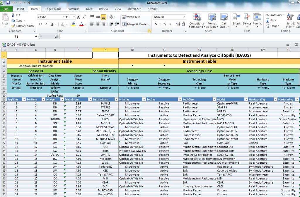
11 Spreadsheet Functional Prototype Sensor/Scenario Matrix Scenario Meta Data Index (A E) Sensor # Scene # Decision Rule Scenario Parameters Sensor Meta Data Sensor Parameters Decision Rule(s) 11
12

13

14
15 Spreadsheet System Functional Prototype Release Pending Spill Scenario Key Parameters Time/Funds Data Base Sensor- Scenario Matrix Composite Scores Selected Technology Performance Score Suitability Ranking Sensor Specifications Web-based Sensor Selector Prototype Under Construction Spill Scenario Key Parameters Time/Funds Sample Query Web-based Selector Response Selected Technology Suitability Ranking Required User Skills Instrument Platform Sensor Category etc. 15
16 Sensor Deployment Modes Monitoring from Oil Platforms on the OCS. Rig2 Hypothetical Spill Modelled using ADIOS, GNOME Satellite Tracking & Mapping in Open Seas Exxon Valdez, Prince William Snd, 260,000 bbl after 3 days Tactical Response Using Aircraft Santa Barbara, Channel, 4,427 bbl, after hrs Deploying All Available Sensors for a Major Spill DWH 2, GoM, 614,944 bbl after 10 days Ship and Aircraft Sensors to Guide Oil Recovery Mega Borg, GoM, 92,857 bbl after 20 days (See Technical Report Part IV for Corresponding Sensor Selections) 16
17 Monitoring from Oil Platforms Semi Enclosed Sea Monitored with Above Surface Sensors. Short (Temporary) and Medium Long term Sampling. Provide Early Detection from Sources on or near a Rig. Deploying All Available Sensors for a Major Spill. Ship and Aircraft Sensors to Guide Oil Recovery. Detect Smaller, Less Obvious Spills. A hypothetical 2 bbl Spill Selects for These Sensors: A/c EPA ASPECT IRLS (4.15,4.40 B) Cost prohibitive if small spill? Rig or Ship Marine Radar Rutter OSD (3.70,3.25 C) Wind effect? Sats World View 1 WV 1 (4.05,4.09 B),GeoEye 1, WV 2 (4.00B) These cannot see through Cloud! => Need for Integrated on Platform Instrument Suite 17
18 Desirable Sensor Characteristics for Monitoring on Oil Platforms Automatic Operation and Data Transfer. Self Diagnostics and Built in Fault Reporting. Routine Maintenance Schedule. Provide Spill Detection Alerts. Local and/or Remote Display and Control. Report Spills Within Sensor Range plus Detection Confidence Level and Criteria. Give Estimates of Spill Location and Size. Ideally Thickness and Oil Type to Mitigate False Alarms. 18
19 The End Questions? 19
Remote Sensing Systems to Detect and Analyze Oil Spills on the U.S. Outer Continental Shelf A State of the Art Assessment
 Naval Research Laboratory Stennis Space Center, MS 39529-5004 NRL/MR/7330--16-9684 Remote Sensing Systems to Detect and Analyze Oil Spills on the U.S. Outer Continental Shelf A State of the Art Assessment
MSRC Tactical Oil Spill Surveillance and Remote Sensing
 MSRC Tactical Oil Spill Surveillance and Remote Sensing Industry Technical Advisory Committee for Oil spill Response October 25, 2016 0 Historical Perspective -- Oil Spill Surveillance in U.S Exxon Valdez
OIL SPILLS IN ICE Remote Sensing
 OIL SPILLS IN ICE Remote Sensing Technology Overview and Upcoming JIP Research David Dickins Chevron IOSC2014 Savannah COLLABORATION AMONG TEN COMPANIES International arctic research programme Builds upon
Identification of Oil Spills from offshore installations.
 Identification of Oil Spills from offshore installations. Presentation of methods and preliminary results from the OSIS, Oil Spill Identification Sensor project. By: Jesper Holst OSIS International Tirsbaekvej
Aerial photography and Remote Sensing. Bikini Atoll, 2013 (60 years after nuclear bomb testing)
") Aerial photography and Remote Sensing Bikini Atoll, 2013 (60 years after nuclear bomb testing) Computers have linked mapping techniques under the umbrella term : Geomatics includes all the following spatial
Aerial photography and Remote Sensing Bikini Atoll, 2013 (60 years after nuclear bomb testing) Computers have linked mapping techniques under the umbrella term : Geomatics includes all the following spatial
Chapter 8. Remote sensing
 1. Remote sensing 8.1 Introduction 8.2 Remote sensing 8.3 Resolution 8.4 Landsat 8.5 Geostationary satellites GOES 8.1 Introduction What is remote sensing? One can describe remote sensing in different
John P. Stevens HS: Remote Sensing Test
 Name(s): Date: Team name: John P. Stevens HS: Remote Sensing Test 1 Scoring: Part I - /18 Part II - /40 Part III - /16 Part IV - /14 Part V - /93 Total: /181 2 I. History (3 pts. each) 1. What is the name
Review of Oil Spill Remote Sensing Technologies. Merv Fingas Spill Science, Edmonton, Alberta, Canada, T6W 1J6,
 Review of Oil Spill Remote Sensing Technologies Merv Fingas Spill Science, Edmonton, Alberta, Canada, T6W 1J6, fingasmerv@shaw.ca Abstract Remote-sensing for oil spills is reviewed. The technical aspects
UAV applications for oil spill detection, suspended matter distribution and ice monitoring first tests and trials in Estonia 2015/2016
 UAV applications for oil spill detection, suspended matter distribution and ice monitoring first tests and trials in Estonia 2015/2016 Sander Rikka Marine Systems Institute at TUT 1.11.2016 1 Outlook Introduction
Microwave Remote Sensing (1)
") Microwave Remote Sensing (1) Microwave sensing encompasses both active and passive forms of remote sensing. The microwave portion of the spectrum covers the range from approximately 1cm to 1m in wavelength.
Microwave Remote Sensing (1) Microwave sensing encompasses both active and passive forms of remote sensing. The microwave portion of the spectrum covers the range from approximately 1cm to 1m in wavelength.
Unmanned Aerial Vehicles: A New Approach for Coastal Habitat Assessment
 Unmanned Aerial Vehicles: A New Approach for Coastal Habitat Assessment David Ryan Principal Marine Scientist WorleyParsons Western Operations 2 OUTLINE Importance of benthic habitat assessment. Common
TRACS A-B-C Acquisition and Processing and LandSat TM Processing
 TRACS A-B-C Acquisition and Processing and LandSat TM Processing Mark Hess, Ocean Imaging Corp. Kevin Hoskins, Marine Spill Response Corp. TRACS: Level A AIRCRAFT Ocean Imaging Corporation Multispectral/TIR
Tracking Surface Oil. Ian R. MacDonald Florida State University
 Tracking Surface Oil Ian R. MacDonald Florida State University White et al. 2016 Oceanography 29 76-87 Overview Oil spill methods where does remote sensing fit in? A flow-chart of remote sensing applications
Multirole data acquisition on operational and scientific aircraft
 Multirole data acquisition on operational and scientific aircraft by T Hengstermann and O Zielinski OPTIMARE Sensorsysteme AG Am Luneort 15a 27572 Bremerhaven Germany Email: sensors@optimare.de Abstract
Active and Passive Microwave Remote Sensing
 Active and Passive Microwave Remote Sensing Passive remote sensing system record EMR that was reflected (e.g., blue, green, red, and near IR) or emitted (e.g., thermal IR) from the surface of the Earth.
Oil Spill Detection (OSD) by using X-band radar
 by using X-band radar") Oil Spill Detection (OSD) by using X-band radar Ina Adegeest, Rutter Inc./ OceanWaveS GmbH, Germany Head Office: Rutter Inc. Canadian company Head Office in St. John s, NL, Canada Incorporated in 1998
Oil Spill Detection (OSD) by using X-band radar Ina Adegeest, Rutter Inc./ OceanWaveS GmbH, Germany Head Office: Rutter Inc. Canadian company Head Office in St. John s, NL, Canada Incorporated in 1998
Sensors, Tools and the Common Operating Picture. Sensors, Tools and the Common Operating Picture 14 th April Middleburg
 Sensors, Tools and the Common Operating Picture 14 th April 2015 - Middleburg Aptomar Established in 2005 Owned by Statoil, Investinor, Proventure Seed, Verdane Capitol Have developed and control all IPR
BSEE Oil Spill Preparedness Division Response Research Branch
 BSEE Oil Spill Preparedness Division Response Research Branch Jay Cho, Ph.D Remote Sensing Research Program To promote safety, protect the environment and conserve resources offshore through vigorous regulatory
JP Stevens High School: Remote Sensing
 1 Name(s): ANSWER KEY Date: Team name: JP Stevens High School: Remote Sensing Scoring: Part I - /18 Part II - /40 Part III - /16 Part IV - /14 Part V - /93 Total: /181 2 I. History (3 pts each) 1. What
Introduction to Remote Sensing Fundamentals of Satellite Remote Sensing. Mads Olander Rasmussen
 Introduction to Remote Sensing Fundamentals of Satellite Remote Sensing Mads Olander Rasmussen (mora@dhi-gras.com) 01. Introduction to Remote Sensing DHI What is remote sensing? the art, science, and technology
Oil spill detection in the Chinese Seas by spaceborne synthetic aperture radars: challenges and pitfalls (Project: OPAC )
") Oil spill detection in the Chinese Seas by spaceborne synthetic aperture radars: challenges and pitfalls (Project: 10705 OPAC ) Werner Alpers Institute of Oceanography, University of Hamburg, Hamburg,
Oil spill detection in the Chinese Seas by spaceborne synthetic aperture radars: challenges and pitfalls (Project: 10705 OPAC ) Werner Alpers Institute of Oceanography, University of Hamburg, Hamburg,
The studies began when the Tiros satellites (1960) provided man s first synoptic view of the Earth s weather systems.
 provided man s first synoptic view of the Earth s weather systems.") Remote sensing of the Earth from orbital altitudes was recognized in the mid-1960 s as a potential technique for obtaining information important for the effective use and conservation of natural resources.
Remote sensing of the Earth from orbital altitudes was recognized in the mid-1960 s as a potential technique for obtaining information important for the effective use and conservation of natural resources.
A MULTIPLE REMOTE SENSOR SYSTEM FOR THE AERIAL SURVEILLANCE OF THE NORTH SEA AND BALTIC SEA*
 A MULTIPLE REMOTE SENSOR SYSTEM FOR THE AERIAL SURVEILLANCE OF THE NORTH SEA AND BALTIC SEA* O. Trieschmann, Th. Hunsänger, U. B. Barjenbruch German Federal Institute of Hydrology 56068 Koblenz, Germany
Well Control Contingency Plan Guidance Note (version 2) 02 December 2015
 02 December 2015") Well Control Contingency Plan Guidance Note (version 2) 02 December 2015 Prepared by Maritime NZ Contents Introduction... 3 Purpose... 3 Definitions... 4 Contents of a Well Control Contingency Plan (WCCP)...
Well Control Contingency Plan Guidance Note (version 2) 02 December 2015 Prepared by Maritime NZ Contents Introduction... 3 Purpose... 3 Definitions... 4 Contents of a Well Control Contingency Plan (WCCP)...
Passive Microwave Sensors LIDAR Remote Sensing Laser Altimetry. 28 April 2003
 Passive Microwave Sensors LIDAR Remote Sensing Laser Altimetry 28 April 2003 Outline Passive Microwave Radiometry Rayleigh-Jeans approximation Brightness temperature Emissivity and dielectric constant
An Introduction to Remote Sensing & GIS. Introduction
 An Introduction to Remote Sensing & GIS Introduction Remote sensing is the measurement of object properties on Earth s surface using data acquired from aircraft and satellites. It attempts to measure something
FLIGHT SUMMARY REPORT
 FLIGHT SUMMARY REPORT Flight Number: 97-011 Calendar/Julian Date: 23 October 1996 297 Sensor Package: Area(s) Covered: Wild-Heerbrugg RC-10 Airborne Visible and Infrared Imaging Spectrometer (AVIRIS) Southern
Co-ReSyF RA lecture: Vessel detection and oil spill detection
 This project has received funding from the European Union s Horizon 2020 Research and Innovation Programme under grant agreement no 687289 Co-ReSyF RA lecture: Vessel detection and oil spill detection
remote sensing? What are the remote sensing principles behind these Definition
 Introduction to remote sensing: Content (1/2) Definition: photogrammetry and remote sensing (PRS) Radiation sources: solar radiation (passive optical RS) earth emission (passive microwave or thermal infrared
PEGASUS : a future tool for providing near real-time high resolution data for disaster management. Lewyckyj Nicolas
 PEGASUS : a future tool for providing near real-time high resolution data for disaster management Lewyckyj Nicolas nicolas.lewyckyj@vito.be http://www.pegasus4europe.com Overview Vito in a nutshell GI
Rutter High Resolution Radar Solutions
 Rutter High Resolution Radar Solutions High Resolution Imagery, Target Detection, and Tracking At the core of our enhanced radar capabilities are proprietary radar processing and imaging technologies.
Module 3 Introduction to GIS. Lecture 8 GIS data acquisition
 Module 3 Introduction to GIS Lecture 8 GIS data acquisition GIS workflow Data acquisition (geospatial data input) GPS Remote sensing (satellites, UAV s) LiDAR Digitized maps Attribute Data Management Data
746A27 Remote Sensing and GIS
 746A27 Remote Sensing and GIS Lecture 1 Concepts of remote sensing and Basic principle of Photogrammetry Chandan Roy Guest Lecturer Department of Computer and Information Science Linköping University What
Microwave Remote Sensing
 Provide copy on a CD of the UCAR multi-media tutorial to all in class. Assign Ch-7 and Ch-9 (for two weeks) as reading material for this class. HW#4 (Due in two weeks) Problems 1,2,3 and 4 (Chapter 7)
NON-PHOTOGRAPHIC SYSTEMS: Multispectral Scanners Medium and coarse resolution sensor comparisons: Landsat, SPOT, AVHRR and MODIS
 NON-PHOTOGRAPHIC SYSTEMS: Multispectral Scanners Medium and coarse resolution sensor comparisons: Landsat, SPOT, AVHRR and MODIS CLASSIFICATION OF NONPHOTOGRAPHIC REMOTE SENSORS PASSIVE ACTIVE DIGITAL
MR-i. Hyperspectral Imaging FT-Spectroradiometers Radiometric Accuracy for Infrared Signature Measurements
 MR-i Hyperspectral Imaging FT-Spectroradiometers Radiometric Accuracy for Infrared Signature Measurements FT-IR Spectroradiometry Applications Spectroradiometry applications From scientific research to
KONGSBERG SATELLITE SERVICES 2017 Line Steinbakk, Director Programs. Himmel og hav - Ålesund 3. Oktober 2017
 KONGSBERG SATELLITE SERVICES 2017 Line Steinbakk, Director Programs Himmel og hav - Ålesund 3. Oktober 2017 KSAT HQ IN TROMSØ 69N Established in 1967 Kongsberg Satellite Services since 2002 World leading
MR-i. Hyperspectral Imaging FT-Spectroradiometers Radiometric Accuracy for Infrared Signature Measurements
 MR-i Hyperspectral Imaging FT-Spectroradiometers Radiometric Accuracy for Infrared Signature Measurements FT-IR Spectroradiometry Applications Spectroradiometry applications From scientific research to
An Introduction to Geomatics. Prepared by: Dr. Maher A. El-Hallaq خاص بطلبة مساق مقدمة في علم. Associate Professor of Surveying IUG
 An Introduction to Geomatics خاص بطلبة مساق مقدمة في علم الجيوماتكس Prepared by: Dr. Maher A. El-Hallaq Associate Professor of Surveying IUG 1 Airborne Imagery Dr. Maher A. El-Hallaq Associate Professor
Outline for today. Geography 411/611 Remote sensing: Principles and Applications. Remote sensing: RS for biogeochemical cycles
 Geography 411/611 Remote sensing: Principles and Applications Thomas Albright, Associate Professor Laboratory for Conservation Biogeography, Department of Geography & Program in Ecology, Evolution, & Conservation
KONGSBERG SATELLITE SERVICES Earth Observation for Maritime Operations Current Capabilities and Future Potential
 KONGSBERG SATELLITE SERVICES 2017 Earth Observation for Maritime Operations Current Capabilities and Future Potential Andreas Hay Kaljord Project Manager KSAT HQ IN TROMSØ - 69N WELCOME TO TROMSØ Established
Geo/SAT 2 INTRODUCTION TO REMOTE SENSING
 Geo/SAT 2 INTRODUCTION TO REMOTE SENSING Paul R. Baumann, Professor Emeritus State University of New York College at Oneonta Oneonta, New York 13820 USA COPYRIGHT 2008 Paul R. Baumann Introduction Remote
Polaris Sensor Technologies, Inc. Visible - Limited Detection Thermal - No Detection Polarization - Robust Detection etherm - Ultimate Detection
 Polaris Sensor Technologies, Inc. DETECTION OF OIL AND DIESEL ON WATER Visible - Limited Detection - No Detection - Robust Detection etherm - Ultimate Detection Pyxis Features: Day or night real-time sensing
REMOTE SENSING INTERPRETATION
 REMOTE SENSING INTERPRETATION Jan Clevers Centre for Geo-Information - WU Remote Sensing --> RS Sensor at a distance EARTH OBSERVATION EM energy Earth RS is a tool; one of the sources of information! 1
9/12/2011. Training Course Remote Sensing Basic Theory & Image Processing Methods September 2011
 Training Course Remote Sensing Basic Theory & Image Processing Methods 19 23 September 2011 Popular Remote Sensing Sensors & their Selection Michiel Damen (September 2011) damen@itc.nl 1 Overview Low resolution
SECOND OPEN SKIES REVIEW CONFERENCE (OSRC) 2010
 2010") OSCC.RC/40/10 9 June 2010 Open Skies Consultative Commission ENGLISH only US Chair of the OSCC Review Conference SECOND OPEN SKIES REVIEW CONFERENCE (OSRC) 2010 7 to 9 June 2010 Working Session 2 Exploring
OSCC.RC/40/10 9 June 2010 Open Skies Consultative Commission ENGLISH only US Chair of the OSCC Review Conference SECOND OPEN SKIES REVIEW CONFERENCE (OSRC) 2010 7 to 9 June 2010 Working Session 2 Exploring
UNERSITY OF NAIROBI UNIT: PRICIPLES AND APPLICATIONS OF REMOTE SENSING AND APLLIED CLIMATOLOGY
 UNERSITY OF NAIROBI DEPARTMENT OF METEOROLOGY UNIT: PRICIPLES AND APPLICATIONS OF REMOTE SENSING AND APLLIED CLIMATOLOGY COURSE CODE: SMR 308 GROUP TWO: SENSORS MEMBERS OF GROUP TWO 1. MUTISYA J.M I10/2784/2006
PRODUCT OVERVIEW FOR THE. Corona 350 II FLIR SYSTEMS POLYTECH AB
 PRODUCT OVERVIEW FOR THE Corona 350 II FLIR SYSTEMS POLYTECH AB Table of Contents Table of Contents... 1 Introduction... 2 Overview... 2 Purpose... 2 Airborne Data Acquisition and Management Software (ADAMS)...
Japan's Greenhouse Gases Observation from Space
 1 Workshop on EC CEOS Priority on GHG Monitoring Japan's Greenhouse Gases Observation from Space 18 June, 2018@Ispra, Italy Masakatsu NAKAJIMA Japan Aerospace Exploration Agency Development and Operation
Sources of Geographic Information
 Sources of Geographic Information Data properties: Spatial data, i.e. data that are associated with geographic locations Data format: digital (analog data for traditional paper maps) Data Inputs: sampled
Joint Industry Program: Development of Improved Ice Management Capabilities for Operations in Arctic and Harsh Environments.
 Joint Industry Program: Development of Improved Ice Management Capabilities for Operations in Arctic and Harsh Environments November 2014 This page is intentionally blank. 2 Introduction Petroleum Research
Copernicus Introduction Lisbon, Portugal 13 th & 14 th February 2014
 Copernicus Introduction Lisbon, Portugal 13 th & 14 th February 2014 Contents Introduction GMES Copernicus Six thematic areas Infrastructure Space data An introduction to Remote Sensing In-situ data Applications
Introduction to Remote Sensing
 Introduction to Remote Sensing Spatial, spectral, temporal resolutions Image display alternatives Vegetation Indices Image classifications Image change detections Accuracy assessment Satellites & Air-Photos
Remote Sensing 1 Principles of visible and radar remote sensing & sensors
 Remote Sensing 1 Principles of visible and radar remote sensing & sensors Nick Barrand School of Geography, Earth & Environmental Sciences University of Birmingham, UK Field glaciologist collecting data
AADE Houston Chapter. Group. 26 January 2011
 AADE Houston Chapter Deepwater and Emerging Technologies Group 26 January 2011 BOEMRE Compliance Guidelines Department of Interior s Increased Safety Measures for Energy Development on the Outer Continental
Polaris Sensor Technologies, Inc. SMALLEST THERMAL POLARIMETER
 Polaris Sensor Technologies, Inc. SMALLEST THERMAL POLARIMETER Pyxis LWIR 640 Industry s smallest polarization enhanced thermal imager Up to 400% greater detail and contrast than standard thermal Real-time
Robots at Work The growing role of robotic systems in the Oceans and Subsea Engineering. David Brookes Senior Advisor, Upstream Engineering, BP
 Robots at Work The growing role of robotic systems in the Oceans and Subsea Engineering David Brookes Senior Advisor, Upstream Engineering, BP Synopsis ROV s History Current Capabilities and Examples AUV
RADAR (RAdio Detection And Ranging)
") RADAR (RAdio Detection And Ranging) CLASSIFICATION OF NONPHOTOGRAPHIC REMOTE SENSORS PASSIVE ACTIVE DIGITAL CAMERA THERMAL (e.g. TIMS) VIDEO CAMERA MULTI- SPECTRAL SCANNERS VISIBLE & NIR MICROWAVE Real
RADAR (RAdio Detection And Ranging) CLASSIFICATION OF NONPHOTOGRAPHIC REMOTE SENSORS PASSIVE ACTIVE DIGITAL CAMERA THERMAL (e.g. TIMS) VIDEO CAMERA MULTI- SPECTRAL SCANNERS VISIBLE & NIR MICROWAVE Real
FOR 353: Air Photo Interpretation and Photogrammetry. Lecture 2. Electromagnetic Energy/Camera and Film characteristics
 FOR 353: Air Photo Interpretation and Photogrammetry Lecture 2 Electromagnetic Energy/Camera and Film characteristics Lecture Outline Electromagnetic Radiation Theory Digital vs. Analog (i.e. film ) Systems
e-navigation Underway International February 2016 Kilyong Kim(GMT Co., Ltd.) Co-author : Seojeong Lee(Korea Maritime and Ocean University)
 Co-author : Seojeong Lee(Korea Maritime and Ocean University)") e-navigation Underway International 2016 2-4 February 2016 Kilyong Kim(GMT Co., Ltd.) Co-author : Seojeong Lee(Korea Maritime and Ocean University) Eureka R&D project From Jan 2015 to Dec 2017 15 partners
e-navigation Underway International 2016 2-4 February 2016 Kilyong Kim(GMT Co., Ltd.) Co-author : Seojeong Lee(Korea Maritime and Ocean University) Eureka R&D project From Jan 2015 to Dec 2017 15 partners
Multispectral Scanners for Wildland Fire Assessment NASA Ames Research Center Earth Science Division. Bruce Coffland U.C.
 Multispectral Scanners for Wildland Fire Assessment NASA Earth Science Division Bruce Coffland U.C. Santa Cruz Slide Fire Burn Area (MASTER/B200) R 2.2um G 0.87um B 0.65um Airborne Science & Technology
9/12/2011. Training Course Remote Sensing Basic Theory & Image Processing Methods September 2011
 Training Course Remote Sensing Basic Theory & Image Processing Methods 19 23 September 2011 Remote Sensing Platforms Michiel Damen (September 2011) damen@itc.nl 1 Overview Platforms & missions aerial surveys
Juan GAVIRIA, Sector Leader AFTTR
 Earth Observation in support of the Western Indian Ocean Marine Highway Development and Coastal and Marine Contamination Prevention Project - Oil spill detection & Coral reef monitoring Juan GAVIRIA, Sector
Western Indian Ocean Marine Highway Development and Coastal and Marine Contamination Prevention Project - Oil spill detection & Coral reef monitoring
 Earth Observation in support of the Western Indian Ocean Marine Highway Development and Coastal and Marine Contamination Prevention Project - Oil spill detection & Coral reef monitoring Juan GAVIRIA, Sector
An Assessment of Surface Surveillance Capabilities for Oil Spill Response using Satellite Remote Sensing
 An Assessment of Surface Surveillance Capabilities for Oil Spill Response using Satellite Remote Sensing Provided for IPIECA and OGP Abstract. This report provides an assessment of satellite surveillance
ISIS TC Meeting. International Spaceborne Imaging Spectroscopy (ISIS) GRSS Technical Committee Meeting, 16/07/2014, IGARSS 2014
 GRSS Technical Committee Meeting, 16/07/2014, IGARSS 2014") ISIS TC Meeting International Spaceborne Imaging Spectroscopy (ISIS) GRSS Technical Committee Meeting, 16/07/2014, IGARSS 2014 Andreas Müller (DLR) Cindy Ong (CSIRO) Uta Heiden (DLR) Agenda Hyperspectral
ISIS TC Meeting International Spaceborne Imaging Spectroscopy (ISIS) GRSS Technical Committee Meeting, 16/07/2014, IGARSS 2014 Andreas Müller (DLR) Cindy Ong (CSIRO) Uta Heiden (DLR) Agenda Hyperspectral
Sustained Ocean Color Research and Operations
 Sustained Ocean Color Research and Operations What are the minimum requirements to continue the SeaWiFS/MODIS time-series? Based on a National Research Council report by the Ocean Studies Board May 2011
Fixed detection devices for oil slick
 Fixed detection devices for oil slick Mikaël Laurent http://www.cedre.fr 715, rue Alain Colas - CS 41836-29218 BREST CEDEX 2 - FRANCE Tél. : +33 2 98 33 10 10 - Fax : +33 2 98 44 91 38 contact@cedre.fr
Lecture Notes Prepared by Prof. J. Francis Spring Remote Sensing Instruments
 Lecture Notes Prepared by Prof. J. Francis Spring 2005 Remote Sensing Instruments Material from Remote Sensing Instrumentation in Weather Satellites: Systems, Data, and Environmental Applications by Rao,
The University of New South Wales
 GMAT 9600 Principles of Remote Sensing Dr. Linlin GE Senior Lecturer Satellite Navigation And Positioning Group School of Surveying & Spatial Information Systems University of New South Wales Phone: +61-2-9385
Deepwater Horizon Mechanical Recovery System Evaluation Interim Report
 Deepwater Horizon Mechanical Recovery System Evaluation Interim Report API TECHNICAL REPORT 1143 SEPTEMBER 2013 Special Notes API publications necessarily address problems of a general nature. With respect
An Assessment of Surface Surveillance Capabilities for Oil Spill Response using Airborne Remote Sensing
 An Assessment of Surface Surveillance Capabilities for Oil Spill Response using Airborne Remote Sensing Provided for IPIECA and OGP Abstract. This report provides an assessment of airborne surveillance
SUBSEA DROPPED OBJECTS. New GoM requirements for 2016 and their wider implicationsengineering Services Feb 2017
 SUBSEA DROPPED OBJECTS New GoM requirements for 2016 and their wider implicationsengineering Services Feb 2017 1 Contents 2 minute Introduction to Wild Well Control - Engineering services The BSEE 2016
Introduction to Remote Sensing
 Introduction to Remote Sensing Outline Remote Sensing Defined Resolution Electromagnetic Energy (EMR) Types Interpretation Applications Remote Sensing Defined Remote Sensing is: The art and science of
Overview of how remote sensing is used by the wildland fire community.
 Overview of how remote sensing is used by the wildland fire community. Presented to the ASEN 6210 Remote Sensing Seminar on 2/18/04 by: Jeff Baranyi ESRI Denver Reported by Gary Fager. Images are from
Remote Sensing for Fire Management. FOR 435: Remote Sensing for Fire Management
 Remote Sensing for Fire Management FOR 435: Remote Sensing for Fire Management 2. Remote Sensing Primer Primer A very Brief History Modern Applications As a young man, my fondest dream was to become a
Sources of Geographic Information
 Sources of Geographic Information Data properties: Spatial data, i.e. data that are associated with geographic locations Data format: digital (analog data for traditional paper maps) Data Inputs: sampled
Remote Sensing Platforms
 Types of Platforms Lighter-than-air Remote Sensing Platforms Free floating balloons Restricted by atmospheric conditions Used to acquire meteorological/atmospheric data Blimps/dirigibles Major role - news
Govt. Engineering College Jhalawar Model Question Paper Subject- Remote Sensing & GIS
 Govt. Engineering College Jhalawar Model Question Paper Subject- Remote Sensing & GIS Time: Max. Marks: Q1. What is remote Sensing? Explain the basic components of a Remote Sensing system. Q2. What is
I. Executive Summary. In addition to CRE s incorporated ICR comments, CRE makes the following comments.
 Center for Regulatory Effectiveness ( CRE ) Comments on Proposed Requirements for Exploratory Drilling on the Arctic Outer Continental Shelf; Bureau of Safety and Environmental Enforcement ( BSEE ), and
Model-Based Design for Sensor Systems
 2009 The MathWorks, Inc. Model-Based Design for Sensor Systems Stephanie Kwan Applications Engineer Agenda Sensor Systems Overview System Level Design Challenges Components of Sensor Systems Sensor Characterization
Introduction to Remote Sensing. Electromagnetic Energy. Data From Wave Phenomena. Electromagnetic Radiation (EMR) Electromagnetic Energy
 Electromagnetic Energy") A Basic Introduction to Remote Sensing (RS) ~~~~~~~~~~ Rev. Ronald J. Wasowski, C.S.C. Associate Professor of Environmental Science University of Portland Portland, Oregon 1 September 2015 Introduction
A Basic Introduction to Remote Sensing (RS) ~~~~~~~~~~ Rev. Ronald J. Wasowski, C.S.C. Associate Professor of Environmental Science University of Portland Portland, Oregon 1 September 2015 Introduction
Active and Passive Microwave Remote Sensing
 Active and Passive Microwave Remote Sensing Passive remote sensing system record EMR that was reflected (e.g., blue, green, red, and near IR) or emitted (e.g., thermal IR) from the surface of the Earth.
A CONCEPT FOR NATURAL GAS TRANSMISSION PIPELINE MONITORING BASED ON NEW HIGH-RESOLUTION REMOTE SENSING TECHNOLOGIES
 A CONCEPT FOR NATURAL GAS TRANSMISSION PIPELINE MONITORING BASED ON NEW HIGH-RESOLUTION REMOTE SENSING TECHNOLOGIES Werner Zirnig - Ruhrgas Aktiengesellschaft Dieter Hausamann - DLR German Aerospace Center
The Marine Well Containment System. LSU Center for Energy Studies Energy Summit 2010 October 26, 2010
 The Marine Well Containment System LSU Center for Energy Studies Energy Summit 2010 October 26, 2010 Restoring Confidence in Deepwater Drilling Operations Our initiatives are aligned with Administration
International Collaborative Engagement Program for Polar Research ICE-PPR. Ministry of Defence Denmark Charlotte Havsteen
 International Collaborative Engagement Program for Polar Research ICE-PPR Ministry of Defence Denmark Charlotte Havsteen Situational Awareness Status Situational awareness Underwater Subsurface Acoustic/Long
Introduction to Remote Sensing of the Environment. Dr. Anne Nolin Department of Geosciences
 Introduction to Remote Sensing of the Environment Dr. Anne Nolin Department of Geosciences Overview of today s lecture Course overview Definitions How measurements are made Analog vs. digital The remote
Remote Sensing. Ch. 3 Microwaves (Part 1 of 2)
") Remote Sensing Ch. 3 Microwaves (Part 1 of 2) 3.1 Introduction 3.2 Radar Basics 3.3 Viewing Geometry and Spatial Resolution 3.4 Radar Image Distortions 3.1 Introduction Microwave (1cm to 1m in wavelength)
Remote Sensing Ch. 3 Microwaves (Part 1 of 2) 3.1 Introduction 3.2 Radar Basics 3.3 Viewing Geometry and Spatial Resolution 3.4 Radar Image Distortions 3.1 Introduction Microwave (1cm to 1m in wavelength)
Integrating Spaceborne Sensing with Airborne Maritime Surveillance Patrols
 22nd International Congress on Modelling and Simulation, Hobart, Tasmania, Australia, 3 to 8 December 2017 mssanz.org.au/modsim2017 Integrating Spaceborne Sensing with Airborne Maritime Surveillance Patrols
ACTIVE SENSORS RADAR
 ACTIVE SENSORS RADAR RADAR LiDAR: Light Detection And Ranging RADAR: RAdio Detection And Ranging SONAR: SOund Navigation And Ranging Used to image the ocean floor (produce bathymetic maps) and detect objects
Remote Sensing Platforms
 Remote Sensing Platforms Remote Sensing Platforms - Introduction Allow observer and/or sensor to be above the target/phenomena of interest Two primary categories Aircraft Spacecraft Each type offers different
Ghazanfar A. Khattak National Centre of Excellence in Geology University of Peshawar
 INTRODUCTION TO REMOTE SENSING Ghazanfar A. Khattak National Centre of Excellence in Geology University of Peshawar WHAT IS REMOTE SENSING? Remote sensing is the science of acquiring information about
Detection and Monitoring Through Remote Sensing....The Need For A New Remote Sensing Platform
 WILDFIRES Detection and Monitoring Through Remote Sensing...The Need For A New Remote Sensing Platform Peter Kimball ASEN 5235 Atmospheric Remote Sensing 5/1/03 1. Abstract This paper investigates the
Introduction Objective and Scope p. 1 Generic Requirements p. 2 Basic Requirements p. 3 Surveillance System p. 3 Content of the Book p.
 Preface p. xi Acknowledgments p. xvii Introduction Objective and Scope p. 1 Generic Requirements p. 2 Basic Requirements p. 3 Surveillance System p. 3 Content of the Book p. 4 References p. 6 Maritime
EE 529 Remote Sensing Techniques. Introduction
 EE 529 Remote Sensing Techniques Introduction Course Contents Radar Imaging Sensors Imaging Sensors Imaging Algorithms Imaging Algorithms Course Contents (Cont( Cont d) Simulated Raw Data y r Processing
Introduction to Remote Sensing Part 1
 Introduction to Remote Sensing Part 1 A Primer on Electromagnetic Radiation Digital, Multi-Spectral Imagery The 4 Resolutions Displaying Images Corrections and Enhancements Passive vs. Active Sensors Radar
EnMAP Environmental Mapping and Analysis Program
 EnMAP Environmental Mapping and Analysis Program www.enmap.org Mathias Schneider Mission Objectives Regular provision of high-quality calibrated hyperspectral data Precise measurement of ecosystem parameters
Advancing Global Deepwater Capabilities
 Advancing Global Deepwater Capabilities BP s Commitment The Deepwater Horizon incident was a tragic accident that took 11 lives and impacted thousands of people and the Gulf environment Going forward,
Outline. Introduction. Introduction: Film Emulsions. Sensor Systems. Types of Remote Sensing. A/Prof Linlin Ge. Photographic systems (cf(
 GMAT x600 Remote Sensing / Earth Observation Types of Sensor Systems (1) Outline Image Sensor Systems (i) Line Scanning Sensor Systems (passive) (ii) Array Sensor Systems (passive) (iii) Antenna Radar
Status of the Joint Industry. Spill Preparedness and Response
 Status of the Joint Industry Research Program to Improve Oil Spill Preparedness and Response David Fritz BP America Latest API report providing update of activities: http://www.api.org/~/media /Files/Oil-and-Natural-