ENHANCING PUBLIC SAFETY AND SECURITY OF CRITICAL NATIONAL INFRASTRUCTURE UTILIZING THE NIGERIAN SATELLITE AUGMENTATION SYSTEM (NSAS)
|
|
|
- Clement Merritt
- 5 years ago
- Views:
Transcription


1 ENHANCING PUBLIC SAFETY AND SECURITY OF CRITICAL NATIONAL INFRASTRUCTURE UTILIZING THE NIGERIAN SATELLITE AUGMENTATION SYSTEM (NSAS) LAWAL LASISI SALAMI & CHRIS R. CHATWIN NIGERIAN COMMUNICATIONS SATELLITE LTD/UNIVERSITY OF SUSSEX,UK. OBASANJO SPACE CENTER, AIRPORT ROAD, LUGBE, ABUJA. GSM No: NSE Annual Conference: SUNSHINE
2 Outline of Presentation Introduction to Global Position System Technique and Augmentation System Needs Assessment of Augmentation GPS Signals, Oscillators, Ultra-Stable Oscillators for Improved Performance NIGCOMSAT-1R Navigational Payload: Africa s Contribution to SBAS and Global Navigation Satellite System (GNSS). Illustration of Regional Satellite Based Augmentation System and NIGCOMSAT-1R SBAS as NSAS. Nigerian Satellite Augmentation System (NSAS) Work in Progress. Benefits, Applications and Derivable Services from NSAS NIGCOMSAT-1R Footprints and Coverage Conclusion References 2
3 Introduction After the first world war, radio time signals offered alternative technology for determination of the Greenwich time and thus longitude at sea. Global Positioning System (GPS) originated from the Navigation System with timing and Ranging Known as NAVSTAR initiated by JPO of US DOD in Initial Operational Capability (IOC) was reached in 1993 with 24 satellites while Full Operational capability (FOC) was declared on July 17 th, Satellite-Based Augmentation System (SBAS) arose from the need to provide continuity, Availability, Integrity and Accuracy of GPS signals to eliminate errors and compensate for discrepancies associated with GPS signals and other navigation systems. The NICOMSAT-1R Navigation (L-Band) payload is a Space Based Augmentation System meant to provide a Navigation Overlay Service (NOS) similar to the European Geostationary Navigation Overlay Service (EGNOS). The paper presents huge untapped potential that the hybrid satellite; NIGCOMSAT-1R offers in the area of public safety, security of critical national infrastructure, aviation, maritime, defense, effectiveness of Location Based Services for Emergency and crisis management amongst other applications and thus fills a great gap in the augmentation system for Africa. 3
4 Needs Assessment of Augmentation An augmentation system can be Ground-Based (GBAS) or Satellite-Based (SBAS) and arises from the need to provide continuity, availability, integrity and accuracy of Global positioning signals to eliminate errors and compensate for discrepancies associated with GPS signals. Augmentation is important in applications that involve safety of life, i.e all phases of flight, which requires improved accuracy of the global positioning signals to eliminate errors and compensate for discrepancies through differential corrections associated with GPS signals and other navigation systems in terms of positioning, velocity and timing requirements of aviation, maritime and land-based transport systems. The most effective augmentation system, especially for coverage capability, is the Satellite-Based Augmentation System (SBAS), which transmits signals over a wide geographic area creating and contributing to the Global Navigation Satellite System (GNSS) regionally for identified primary and secondary users in a mix controlled and free market. 4
5 GPS Signals, Oscillators, Ultra-Stable Oscillators for Improved Performance. The GPS is primarily a ranging system as it tries to find how far an object is from itself (satellite) through principle of trilateration. Generally, for a GPS receiver to work properly, its is expected to carry out four tasks, namely: Find GPS signals i.e frequency, code phase Track and demodulate the message from each GPS satellite at the same time. Calculate the position based on distances to the satellites Calculate the correction to your local clock. NSE Annual Conference: SUNSHINE
 showing its Crystal Resonator and")

6 GPS Signals, Oscillators, Ultra-Stable Oscillators for Improved Performance. Dana, 1999 with Permission A Typical Ovenized Crystal Oscillator (OXCO) showing its Crystal Resonator and external circuits in a proportionally controlled oven to compensate ambient temperature changes. The 10MHz Master oscillator used in the navigation payload of the Nigerian Communications Satellite (NIGCOMSAT-1R). NSE Annual Conference: SUNSHINE
, a quad-band high powered satellite with navigational")


7 NIGCOMSAT-1R NAVIGATION PAYLOAD: AFRICA S CONTRIBUTION TO SBAS and GLOBAL NAVIGATION SATELLITE SYSTEM (GNSS). Nigeria s first communication satellite (NIGCOMSAT-1), a quad-band high powered satellite with navigational capability and capacity launched on 14th May, 2007 NIGCOMSAT-1R was Africa s first contribution to the Global Navigation Satellite System. It was however de-orbited on the 10th of November, 2008 due to an irreparable single point of failure on-board the satellite. All broadcast, telecommunication services being offered by the satellite including strategic navigational plans and objectives were disrupted. The NIGCOMSAT-1R spacecraft project, is the insurance replacement for the NIGCOMSAT-1 satellite launched on 19 th December, MHz ultra stable crystal oscillator was used for the L- band payload to meet the performance requirements of frequency conversion stability and accuracy.
.")


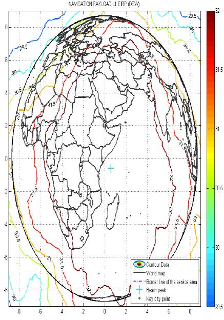
8 NIGCOMSAT-1R NAVIGATION PAYLOAD: AFRICA S CONTRIBUTION TO SBAS and GLOBAL NAVIGATION SATELLITE SYSTEM (GNSS). The downlink coverage beam of NIGCOMSAT-1R Geo-Navigation Satellite using L Band Helix Antenna. NIGCOMSAT Master Control Station with C-L Band Antenna Systems The downlink coverage beam of NIGCOMSAT-1R Geo-Navigation Satellite on L1 Frequency The downlink coverage beam of NIGCOMSAT-1R Geo-Navigation Satellite on L5 Frequency

9 Illustration of Regional Satellite Based Augmentation System and NIGCOMSAT-1R SBAS as NSAS WAAS: US Wide Area Augmentation System EGNOS: European Geostationary Navigation Overlay Service CWAAS: Canadian Wide Area Augmentation System MSAS: Japanese MTSAT Satellite Augmentation System SNAS: Chinese Satellite Navigation Augmentation System NSAS: Nigerian Satellite Augmentation System
 DEPLOYED WHILE GROUND INFRASTRUCTURE")
10 NIGERIAN SATELLITE AUGMENTATION SYSTEM (NSAS)..SPACE-BASED ASSET (SBAS) DEPLOYED WHILE GROUND INFRASTRUCTURE IMPLEMENTATION IS STILL WORK IN PROGRESS.

11 RELEVANCE, APPLICATION AND ECONOMIC IMPORTANCE OF NIGERIAN SATELLITE AUGMENTATION SYSTEM The African Regional Satellite Based Augmentation System through NIGCOMSAT-1R SBAS will serve the followings: Military Applications: Defence, Surveillance, Tracking and Monitoring Ground and Aerial Based Assets including Personnel in hot spots. Improve Emergency, Recovery services and Search & Rescue. Fleet Management Systems and Telematics Transportation Land: Car Users, Fleet Management outlets, Cargo Companies, Postal Agencies. Maritime Aviation Land Surveying (Mapping) Telematic equipment and Demobilizers for Anti-Car Theft, Fleet Management etc.

12 RELEVANCE, APPLICATION AND ECONOMIC IMPORTANCE OF NIGERIAN SATELLITE AUGMENTATION SYSTEM Public Safety: Tall Buildings, Bridges etc Security of National Infrastructure: Pipelines, Power Lines, Gas Reservoirs, Strategic national Infrastructures Insurance Companies Paramilitary organization, Security Agencies Emergency Agencies: NEMA, Fire Fighters, FRSC etc Utility Management: Energy and Communications Company for synchronization. Geographic Information System Companies Tourism Environmental Protection and Characterization Scientific Research. PUBLIC SAFETY APPLICATIONS IN CONSTRUCTION, BUILDINGS AND BRIDGES: GNSS receivers at critical control points of a bridge or buildings to monitor public safety of the infrastructure from trended graph over time.


13 NIGCOMSAT-1R FOOTPRINTS AND COVERAGE. ECOWAS C-BAND COVERAGE ECOWAS I KU-BAND COVERAGE ECOWAS II KU-BAND COVERAGE ASIA KU-BAND COVERAGE KA-BAND COVERAGE OVER NIGERIA KA-BAND COVERAGE OVER SOUTH AFRICA KA-BAND COVERAGE OVER EUROPE GLOBAL NAVIGATIONAL COVERAGE IN L-BAND 13
14 Conclusion The Nigerian Satellite Augmentation System as Africa s contribution to the Global Navigation Satellite System (GNSS) exploiting NIGCOMSAT- 1R SBAS will improve emergency & Recovery services, Fleet management systems, Transportation (Land, Maritime, and Aeronautical applications), Agriculture, Land Surveying and Utility Management. The drive for improved performance has also encouraged improved system architecture that allows convergence of all regional and continental navigational systems into compatible and interoperable Global Navigational Satellite Services (GNSS). Combined use of GPS, GLONASS and any other regional GNSS systems, increases the number of satellites in different orbital planes reducing Dilution of Precision (DOP) (position in 3 dimensions and Geometric) thus saving time in acquisition of signals and improved performance by using multi-chip receivers for Location Based Services (LBS). Completion of NSAS project will facilitate an enabling environment for investment, enhanced productivity for economic growth, development, employment generation and wealth creation and above all enhanced public safety and security of critical national infrastructure.
15 References 1. Ambrosini, R. (2000). Measurements of Allan Variance and Short Term Phase Noise of Millimeter Local Oscillators. Institute of Radio Astronomy, CNR,Italy. 2. Asmar, S.W.( 1997). Characteristics Trends of Ultrastable Oscillators for Radio Science Experiments. TDA Progress Report (42-129). 3. Bloch, M., Mancini, O., & McClelland, T. (2009). Effects of Radiation on Performance of Space-Borne Quartz Crystal Oscillators. IEEE International Frequency Control Symposium Joint with 22 nd European Frequency and Time Forum, ( ), Besancon. doi: /FREQ Dana, P.H. (1999). The Global Positioning System Overview: The Geographer s Craft. Retrieved from: 5. Davies, A.C. (1978). The life and death of a scientific instrument: The marine chronometer, Annals of Science, 35(5), doi: / Retrieved from: 7. Gregory, T.F. (1996). Understanding the GPS: An introduction to the Global Positioning System. 8. Gregory, W., Matthew, R., & Mihran, M. (2004). Developments in Ultra-Stable Quartz Oscillators for Deep Space Reliability. 36th Annual Precise Time and Time Interval (PTTI) Meeting ( ), USA. 9. Hong, S., Xiaohong, J., & John, X. (2008). Study of Fundamental Limit and Packaging Technology Solutions for 40 Gbps Transceiver Package Design. Altera Corporation, DesignCon, CP John, R.V. (1992). Introduction to Quartz Frequency Standards. Research and Development Technical Report, Army Research Laboratory, SLCET-TR-92-1 (Rev. 1) Retrieved from : Jun, X., & Xuchu, M. (2008). Implementation of FPGA-Based Acquisition of Weak GPS Signals. International Symposium on GPS/GNSS, Tokyo. 12. Kowoma. (2009, April 19). The GPS System. Retrieved from: Lawal, L.S., & Chatwin, C.R. (2011). Essential Parameters of Space-Borne Oscillators That Ensures Performance of Satellite-Based Augmentation System. Proceedings of 3 rd IEEE International Conference on Science and Technology, ICAST, (pp42-50). Abuja-Nigeria. doi: /ICASTech Lawal, L.S., Ahmed-Rufai, T., Chatwin, C.R., & Young, R.C.D. (2013). Delivery of Broadband Services to Sub-Saharan Africa via Nigerian Communications Satellite. International Journal of Information and Computer Science (IJICS). 2(5), Lawal, L, S. (2014). Economically Sustainable Public Security and Emergency Network exploiting a Broadband Communications Satellite (PhD Thesis). University of Sussex, Brighton, United Kingdom. 16. Lawal, L.S & Chatwin, C.R. (2014). Emergency Communication Preparedness in Africa Exploiting Communication Satellites. Global Space Applications Conference (GLAC) by International Astronautical Federation (IAF) and United Nations Educational, Scientific and Cultural Organization (UNESCO) on 2-4 June, 2014 at UNESCO HQ, Paris, France. Retrieved from NigComSat-1R. (2009). Preliminary Design Review (PDR) and Critical Design Review (CDR) of NIGCOMSAT-1R Communications Satellite Project. Nigerian Communications Satellite Limited. Abuja, Nigeria: NIGCOMSAT-1R. 18. NPC NIIMP Draft Final Report (July, 2013). National Integrated Infrastructure Master Plan (NIIMP) Parkinson, B.W., & Spilker, J.J. (1996). Global Positioning System: Theory and Applications. Volume I. 20. Parkinson, K.J., Dempster, A.G., Mumford, P., & Rizos, C. (2006). FPGA based GPS receiver design considerations. Journal of Global Positioning Systems, 5, (1-2), Retrieved from: Sung, C.B., Gyu, I.J., Hun, S.C., & Sung, H.I. (2004). A FPGA-Based Software GPS Receiver Design using Simulink. International Symposium on GNSS/GPS, Sydney. 22. Vig, J.R. (2007). Quartz Crystal Resonators and Oscillators for Frequency Control and Timing Applications, (Rev ). Retrieved from : Villaveces, J. (2011). Disaster Response 2.0. Forced Migration Review, 38, Yung, L.H., Trong, Y.L., Che, C.H., Chia, C.T., & Rong, S.H (2006). A Low-Cost GPS Satellite Signal Baseband System Using FPGA Prototyping. Retrieved from: yping/ Zedong, N., Kangling, F., & Xu, X. (2006). A Portable Positioning System Based on SOPC Technology. 8 th International Conference on signal Processing, Beijing, doi: /ICOSP


16 Questions?? 16
Nigerian Communications Satellite Ltd. (NIGCOMSAT)
") OVERVIEW OF NIGERIAN SATELLITE AUGMENTATION SYSTEM COMMENCING WITH PILOT DEMONSTRATION TO VALIDATE NATIONAL WORK PLAN presented by Dr. Lawal Lasisi Salami, NIGERIAN COMMUNICATIONS SATELLITE LTD UNDER FEDERAL
OVERVIEW OF NIGERIAN SATELLITE AUGMENTATION SYSTEM COMMENCING WITH PILOT DEMONSTRATION TO VALIDATE NATIONAL WORK PLAN presented by Dr. Lawal Lasisi Salami, NIGERIAN COMMUNICATIONS SATELLITE LTD UNDER FEDERAL
European Geostationary Navigation Overlay Service (EGNOS) Capability on Sirius 5 Satellite for SES
 Capability on Sirius 5 Satellite for SES") 21 October 2009 SES SIRIUS European Geostationary Navigation Overlay Service (EGNOS) Capability on Sirius 5 Satellite for SES Mike Pavloff, Executive Director, Space Systems/Loral Information included
21 October 2009 SES SIRIUS European Geostationary Navigation Overlay Service (EGNOS) Capability on Sirius 5 Satellite for SES Mike Pavloff, Executive Director, Space Systems/Loral Information included
Lecture-1 CHAPTER 2 INTRODUCTION TO GPS
 Lecture-1 CHAPTER 2 INTRODUCTION TO GPS 2.1 History of GPS GPS is a global navigation satellite system (GNSS). It is the commonly used acronym of NAVSTAR (NAVigation System with Time And Ranging) GPS (Global
SATELLITE BASED AUGMENTATION SYSTEM (SBAS) FOR AUSTRALIA
 FOR AUSTRALIA") SATELLITE BASED AUGMENTATION SYSTEM (SBAS) FOR AUSTRALIA AN AIN POSITION PAPER SUBMITTED TO VARIOUS GOVERNMENT DEPARTMENTS BY MR KYM OSLEY AM, CSC, EXEC SECRETARY AIN What are GNSS Augmentation Systems?
SATELLITE BASED AUGMENTATION SYSTEM (SBAS) FOR AUSTRALIA AN AIN POSITION PAPER SUBMITTED TO VARIOUS GOVERNMENT DEPARTMENTS BY MR KYM OSLEY AM, CSC, EXEC SECRETARY AIN What are GNSS Augmentation Systems?
GBAS FOR ATCO. June 2017
 GBAS FOR ATCO June 2017 Disclaimer This presentation is for information purposes only. It should not be relied on as the sole source of information, and should always be used in the context of other authoritative
Challenges and Solutions for GPS Receiver Test
 Challenges and Solutions for GPS Receiver Test Presenter: Mirin Lew January 28, 2010 Agenda GPS technology concepts GPS and GNSS overview Assisted GPS (A-GPS) Basic tests required for GPS receiver verification
The topic we are going to see in this unit, the global positioning system, is not directly related with the computer networks we use everyday, but it
 The topic we are going to see in this unit, the global positioning system, is not directly related with the computer networks we use everyday, but it is indeed a kind of computer network, as the specialised
GLOBAL POSITIONING SYSTEMS. Knowing where and when
 GLOBAL POSITIONING SYSTEMS Knowing where and when Overview Continuous position fixes Worldwide coverage Latitude/Longitude/Height Centimeter accuracy Accurate time Feasibility studies begun in 1960 s.
Overview of the global GNSS market and status of Galileo
 2012 GNSS.asia workshop Overview of the global GNSS market and status of Galileo 6 November, 2012 Taipei Justyna Redelkiewicz, European GNSS Agency European GNNS Agency supports European Commission in
Understanding GPS/GNSS
 Understanding GPS/GNSS Principles and Applications Third Edition Contents Preface to the Third Edition Third Edition Acknowledgments xix xxi CHAPTER 1 Introduction 1 1.1 Introduction 1 1.2 GNSS Overview
Published Papers and Conference Proceedings:
 Published Papers and Conference Proceedings: 1987 1. History of Maritime Radiocommunications, Our Sea, No. 5-6, Dubrovnik, Croatia, 1987. 2. Maritime satellite communications, Nautical Courier, No.4, Beograd,
DEFINING THE FUTURE OF SATELLITE SURVEYING WITH TRIMBLE R-TRACK TECHNOLOGY
 DEFINING THE FUTURE OF SATELLITE SURVEYING WITH TRIMBLE R-TRACK TECHNOLOGY EDMOND NORSE, GNSS PORTFOLIO MANAGER, TRIMBLE SURVEY DIVISION WESTMINSTER, CO USA ABSTRACT In September 2003 Trimble introduced
Current status of Quasi-Zenith Satellite System. Japan Aerospace Exploration Agency QZSS Project Team
 Current status of Quasi-Zenith Satellite System Japan Aerospace Exploration Agency QZSS Project Team 1 Quasi-Zenith Satellite System The QZSS is a regional space-based PNT (Positioning, Navigation and
Dimov Stojče Ilčev. CNS Systems
 Stratospheric Platform Systems (SPS) Presentation by: Dimov Stojče Ilčev Durban University of Technology (DUT) Space Science Centre (SSC) CNS Systems August 2011 SPS for Mobile CNS Applications Stratospheric
GPS and Recent Alternatives for Localisation. Dr. Thierry Peynot Australian Centre for Field Robotics The University of Sydney
 GPS and Recent Alternatives for Localisation Dr. Thierry Peynot Australian Centre for Field Robotics The University of Sydney Global Positioning System (GPS) All-weather and continuous signal system designed
SBAS solution GCC, Yemen and Iraq System baseline and performance
 SBAS solution GCC, Yemen and Iraq System baseline and performance ACAC Workshop Rabat 7 & 8 November 2017 1 2017 Thales Alenia Space PROPRIETARY C O M MINFORMATION E R C I A L I N THALES C O ALENIA N F
Expert Dialogue on Real-time Monitoring of Flight Data. Patrick M. French Head, Business Development Asia-Pacific 26 May 2014
 1 Expert Dialogue on Real-time Monitoring of Flight Data Patrick M. French Head, Business Development Asia-Pacific 26 May 2014 2 Intelsat is the Leading Global Provider of Commercial Satellite Services
PRELIMINARY PROGRAMME
 ICG EXPERTS MEETING: GLOBAL NAVIGATION SATELLITE SYSTEMS SERVICES 14-18 December 2015 Vienna International Centre, Vienna, Austria Organized by International Committee on Global Navigation Satellite Systems
Global Navigation Satellite System (GNSS) GPS Serves Over 400 Million Users Today. GPS is used throughout our society
 GPS Serves Over 400 Million Users Today. GPS is used throughout our society") Global avigation Satellite System (GSS) For freshmen at CKU AA December 10th, 2009 by Shau-Shiun Jan ICA & IAA, CKU Global avigation Satellite System (GSS) GSS (Global Positioning System, GPS) Basics Today
Global avigation Satellite System (GSS) For freshmen at CKU AA December 10th, 2009 by Shau-Shiun Jan ICA & IAA, CKU Global avigation Satellite System (GSS) GSS (Global Positioning System, GPS) Basics Today
GPS (Introduction) References. Terms
 References. Terms") GPS (Introduction) WCOM2, GPS, 1 Terms NAVSTAR GPS ( Navigational Satellite Timing and Ranging - Global Positioning System) is a GNSS (Global Navigation Satellite System), developed by the US-DoD in 197x
GPS (Introduction) WCOM2, GPS, 1 Terms NAVSTAR GPS ( Navigational Satellite Timing and Ranging - Global Positioning System) is a GNSS (Global Navigation Satellite System), developed by the US-DoD in 197x
BENEFITS OF A SPACE-BASED AUGMENTATION SYSTEM FOR EARLY IMPLEMENTATION OF GPS MODERNIZATION SIGNALS
 BENEFITS OF A SPACE-BASED AUGMENTATION SYSTEM FOR EARLY IMPLEMENTATION OF GPS MODERNIZATION SIGNALS Alison Brown and Sheryl Atterberg, NAVSYS Corporation BIOGRAPHY Alison Brown is the President and CEO
The Global Positioning System
 The Global Positioning System 5-1 US GPS Facts of Note DoD navigation system First launch on 22 Feb 1978, fully operational in 1994 ~$15 billion (?) invested to date 24 (+/-) Earth-orbiting satellites
Understanding GPS: Principles and Applications Second Edition
 Understanding GPS: Principles and Applications Second Edition Elliott Kaplan and Christopher Hegarty ISBN 1-58053-894-0 Approx. 680 pages Navtech Part #1024 This thoroughly updated second edition of an
GPS Milestones, cont. GPS Milestones. The Global Positioning Sytem, Part 1 10/10/2017. M. Helper, GEO 327G/386G, UT Austin 1. US GPS Facts of Note
 The Global Positioning System US GPS Facts of Note DoD navigation system First launch on 22 Feb 1978, fully operational in 1994 ~$15 billion (?) invested to date 24 (+/-) Earth-orbiting satellites (SVs)
Prospect for Global Positioning Augmentation Service by QZSS
 Prospect for Global Positioning Augmentation Service by QZSS Global Positioning Augmentation Service Corporation Director, Yoshikatsu Iotake Feb. 6, 2018 Copyright 2018 Global Positioning Augmentation
Japanese Regional Navigation Satellite System The JRANS Concept
 Journal of Global Positioning Systems (2004) Vol. 3, No. 1-2: 259-264 Japanese Regional Navigation Satellite System The JRANS Concept Hideto (Duke) Takahashi ITOCHU Corporation, 2-5-1, Kita Aoyama, Minato-ku,
EC UA Aviation Conference, Windhoek, Namibia, April 2 & 3, 2009
 EC UA Aviation Conference, Windhoek, Namibia, April 2 & 3, 2009 Session 7 : EU-Africa Civil Aviation Co-operation 1 Contents Page 2 Who is Thales Alenia Space Thales Alenia Space contribution to Air Traffic
Status of the European EGNOS and Galileo Programmes. Frank Udnaes Galileo policy and Infrastructure group EC DG-TREN. June 2008
 Status of the European EGNOS and Galileo Programmes Frank Udnaes Galileo policy and Infrastructure group EC DG-TREN EUROPEAN COMMISSION z June 2008 Galileo An infrastructure 30 satellite Constellation
GPS/WAAS Program Update
 GPS/WAAS Program Update UN/Argentina Workshop on the Applications of GNSS 19-23 March 2018 Cordoba, Argentina GNSS: A Global Navigation Satellite System of Systems Global Constellations GPS (24+3) GLONASS
SPACE SYSTEM AND ENGINEERING IN AFRICA: NIGERIA AS A CASE STUDY
 SPACE SYSTEM AND ENGINEERING IN AFRICA: NIGERIA AS A CASE STUDY THE 4 th AFRICAN LEADERSHIP CONFERENCE ON SPACE SCIENCE AND TECHNOLOGY FOR SUSTAINABLE DEVELOPMENT - ALC-2011 Building a Shared Vision for
One Source for Positioning Success
 novatel.com One Source for Positioning Success RTK, PPP, SBAS OR DGNSS. NOVATEL CORRECT OPTIMIZES ALL CORRECTION SOURCES, PUTTING MORE POWER, FLEXIBILITY AND CONTROL IN YOUR HANDS. NovAtel CORRECT is the
Development of BeiDou Navigation Satellite System
 The 8 th Meeting of the International Committee on GNSS Development of BeiDou Navigation Satellite System China Satellite Navigation Office Dubai, UAE November, 2013 Contents Contents 1. Objectives and
SPECIAL EFFECTS OF THE REGIONAL SATELLITE AUGMENTATION SYSTEM (RSAS)
") St. D. Ilcev (Mangosuthu University of Technology (MUT) South Africa) SPECIAL EFFECTS OF THE REGIONAL SATELLITE AUGMENTATION SYSTEM (RSAS) This paper introduces the special effects of the new developed
St. D. Ilcev (Mangosuthu University of Technology (MUT) South Africa) SPECIAL EFFECTS OF THE REGIONAL SATELLITE AUGMENTATION SYSTEM (RSAS) This paper introduces the special effects of the new developed
Indian GNSS Industry Overview Challenges and future prospects
 Indian GNSS Industry Overview Challenges and future prospects Expert Presentation By Dr. S.V. Kibe Consultant, SATCOM & GNSS, Bangalore, India (Former Programme Director, SATNAV,ISRO HQ) On February 20,2013
SNAV: SBAS self-standing Navigation Payload based on Artemis Experience.
 SNAV: SBAS self-standing Navigation Payload based on Artemis Experience. S. Badessi, G. Oppenhäuser, J. Ventura-Traveset European Space Agency F. Palamidessi, G. Leggeri Alenia Aerospazio Abstract The
GPS (Introduction) References. Terms
 References. Terms") GPS (Introduction) MSE, Rumc, GPS, 1 Terms NAVSTAR GPS ( Navigational Satellite Timing and Ranging - Global Positioning System) is a GNSS (Global Navigation Satellite System), developed by the US-DoD in
GPS (Introduction) MSE, Rumc, GPS, 1 Terms NAVSTAR GPS ( Navigational Satellite Timing and Ranging - Global Positioning System) is a GNSS (Global Navigation Satellite System), developed by the US-DoD in
Galileo - European Global Navigation Satellite System
 Abstract Galileo - European Global Navigation Satellite System Wu Chen Department of Land Surveying and Geoinformatics Hong Kong Polytechnic University e-mail: Lswuchen@polyu.du.hk Washington Yotto Ochieng
«Current state and prospects of development of commercial application GLONASS/GNSS in the Russian Federation»
 «Current state and prospects of development of commercial application GLONASS/GNSS in the Russian Federation» United Nations SYMPOSIUM TO STRENGTHEN THE PARTNERSHIP WITH INDUSTRY COMMERCIAL APPLICATIONS
Status of COMPASS/BeiDou Development
 Status of COMPASS/BeiDou Development Stanford s 2009 PNT Challenges and Opportunities Symposium October 21-22,2009 Cao Chong China Technical Application Association for GPS Contents 1. Basic Principles
GNSS Programme. Overview and Status in Europe
 GNSS Programme Overview and Status in Europe Inaugural Forum Satellite Positioning Research and Application Center 23 April 2007 Tokyo Presented by Thomas Naecke (European Commission) Prepared by Daniel
S-Band: a new space for mobile communication in Europe Orazio Pulvirenti MSS Project Manager Eutelsat Innovation Team
 S-Band: a new space for mobile communication in Europe Orazio Pulvirenti MSS Project Manager Eutelsat Innovation Team Evolutions in Satellite Telecommunication Ground Segments Noordwijk, June 5 th 2008
Introduction to Geographic Information Science. Last Lecture. Today s Outline. Geography 4103 / GNSS/GPS Technology
 Geography 4103 / 5103 Introduction to Geographic Information Science GNSS/GPS Technology Last Lecture Geoids Ellipsoid Datum Projection Basics Today s Outline GNSS technology How satellite based navigation
CLICK HERE TO KNOW MORE
 CLICK HERE TO KNOW MORE Should GNSS Become a National Critical Infrastructure? Ooi Wei Han, Noordin Ahmad, Shahrizal IM National Space Agency (ANGKASA) Ministry of Science, Technology and Innovation (MOSTI)
The last 25 years - GPS to multi-gnss: from a military tool to the most widely used civilian positioning solution
 1 The last 25 years - GPS to multi-gnss: from a military tool to the most widely used civilian positioning solution B. Hofmann-Wellenhof Institute of Geodesy / Navigation, Graz University of Technology
Development of Ultimate Seamless Positioning System for Global Cellular Phone Platform based on QZSS IMES
 Development of Ultimate Seamless Positioning System for Global Cellular Phone Platform based on QZSS IMES Dinesh Manandhar, Kazuki Okano, Makoto Ishii, Masahiro Asako, Hideyuki Torimoto GNSS Technologies
Introduction to the Global Positioning System
 GPS for Fire Management - 2004 Introduction to the Global Positioning System Pre-Work Pre-Work Objectives Describe at least three sources of GPS signal error, and identify ways to mitigate or reduce those
BeiDou Next Generation Signal Design and Expected Performance
 International Technical Symposium on Navigation and Timing ENAC, 17 Nov 2015 BeiDou Next Generation Signal Design and Expected Performance Challenges and Proposed Solutions Zheng Yao Tsinghua University
CONSIDERATIONS FOR GNSS MEASUREMENTS
 CONSIDERATIONS FOR GNSS MEASUREMENTS Cornel PĂUNESCU 1, Cristian VASILE 2, Cosmin CIUCULESCU 3 1 PhD University of Bucharest, e-mail: cornelpaun@gmail.com 2 Lecturer PhD University of Craiova, cristi_vasile_4you@yahoo.com
High Precision Navigation Capabilities(L1-SAIF) and Applications Using Japanese Quasi-Zenith Satellite System (QZSS)
 and Applications Using Japanese Quasi-Zenith Satellite System (QZSS)") High Precision Navigation Capabilities(L1-SAIF) and Applications Using Japanese Quasi-Zenith Satellite System (QZSS) ICG WG-B Application SG Meeting Munich, Germany March 12, 2012 Satellite Positioning
High Precision Navigation Capabilities(L1-SAIF) and Applications Using Japanese Quasi-Zenith Satellite System (QZSS) ICG WG-B Application SG Meeting Munich, Germany March 12, 2012 Satellite Positioning
Wide Area Augmentation System (WAAS)
") Wide Area Augmentation System (WAAS) Ionospheric Effects Symposium By: Jason Burns Technology Evolution Lead Date: Agenda WAAS Overview Ionospheric Effects on WAAS Future Plans User Segment Update 2 WAAS
Wide Area Augmentation System (WAAS) Ionospheric Effects Symposium By: Jason Burns Technology Evolution Lead Date: Agenda WAAS Overview Ionospheric Effects on WAAS Future Plans User Segment Update 2 WAAS
Introduction to NAVSTAR GPS
 Introduction to NAVSTAR GPS Charlie Leonard, 1999 (revised 2001, 2002) The History of GPS Feasibility studies begun in 1960 s. Pentagon appropriates funding in 1973. First satellite launched in 1978. System
FieldGenius Technical Notes GPS Terminology
 FieldGenius Technical Notes GPS Terminology Almanac A set of Keplerian orbital parameters which allow the satellite positions to be predicted into the future. Ambiguity An integer value of the number of
EGNOS/GALILEO Status. Rafael Lucas Navigation Applications and User Services Office European Space Agency
 EGNOS/GALILEO Status Rafael Lucas Navigation Applications and User Services Office European Space Agency Rafael.Lucas.Rodriguez@esa.int European Satellite Navigation Strategy GNSS1: EGNOS Civil complement
ASSEMBLY 37TH SESSION
 International Civil Aviation Organization WORKING PAPER A37-WP/195 1 22/9/10 (Information paper) ASSEMBLY 37TH SESSION TECHNICAL COMMISSION Agenda Item 35: The Global Air Traffic Management (ATM) System
Technical Specifications Document. for. Satellite-Based Augmentation System (SBAS) Testbed
 Testbed") Technical Specifications Document for Satellite-Based Augmentation System (SBAS) Testbed Revision 3 13 June 2017 Table of Contents Acronym Definitions... 3 1. Introduction... 4 2. SBAS Testbed Realisation...
Technical Specifications Document for Satellite-Based Augmentation System (SBAS) Testbed Revision 3 13 June 2017 Table of Contents Acronym Definitions... 3 1. Introduction... 4 2. SBAS Testbed Realisation...
Radio Navigation Aids Flight Test Seminar
 Radio Navigation Aids Flight Test Seminar FLIGHT INSPECTION IN THE NEW MILLENNIUM Curt Keedy FAA Flight Inspection Policy and Standards Change, Challenge, and Opportunity CHANGES Global Positioning system
Monitoring Station for GNSS and SBAS
 Monitoring Station for GNSS and SBAS Pavel Kovář, Czech Technical University in Prague Josef Špaček, Czech Technical University in Prague Libor Seidl, Czech Technical University in Prague Pavel Puričer,
GPS/GNSS What is it? How Does it Work? What are its Applications?
 GPS/GNSS What is it? How Does it Work? What are its Applications? Historic Navigation Reference points in the sky used for navigation The Sun The Pole Star / North Star Southern Cross Gives Direction,
Aircraft Landing Systems Based on GPS & Galileo
 Aircraft Landing Systems Based on GPS & Galileo for the Czech Technical University by Per Enge Thursday 4 August, 2005 Future Aircraft Landing Systems: Outline 1. Today: Global Positioning System (GPS)
GLOBAL POSITIONING SYSTEMS
 GLOBAL POSITIONING SYSTEMS GPS & GIS Fall 2017 Global Positioning Systems GPS is a general term for the navigation system consisting of 24-32 satellites orbiting the Earth, broadcasting data that allows
METIS Second Master Training & Seminar. Augmentation Systems Available in Egypt
 METIS Second Master Training & Seminar Augmentation Systems Available in Egypt By Eng. Ramadan Salem M. Sc. Surveying and Geodesy Email: ramadan_salem@link.net Page 1 Augmentation Systems Available in
Satellite navigation applications: opportunities from the European GNSS. Fiammetta Diani Deputy Head of Market Development European GNSS Agency
 Satellite navigation applications: opportunities from the European GNSS Fiammetta Diani Deputy Head of Market Development European GNSS Agency FP7 success story in Lithuania COSUDEC Coastal Surveying of
W-Band Satellite Transmission in the WAVE Mission
 W-Band Satellite Transmission in the WAVE Mission A. Jebril, M. Lucente, M. Ruggieri, T. Rossi University of Rome-Tor Vergata, Dept. of Electronic Engineering, Via del Politecnico 1, 00133 Rome - Italy
GAGAN Initiatives Jan 18, 2018
 GAGAN Initiatives Jan 18, 2018 Topics covered 1. Brief profile of GAGAN 2. Features / Accuracy of GAGAN System 3. GAGAN Architecture 4. GAGAN services and Coverage 5. GAGAN utilization in aviation sector
FAST AND LIABLE CARTOGRAPHY UPDATE USING EGNOS AND GALILEO
 (1) (2) FAST AND LIABLE CARTOGRAPHY UPDATE USING EGNOS AND GALILEO Manuel Toledo (1), Angel Gavín (2) GMV S.A., Isaac Newton 11, P.T.M. Tres Cantos, 28760 Madrid, Spain, E-mail: mtoledo@gmv.es; agavin@gmv.es
Precise Positioning... what does it mean? Precise GNSS Positioning Not just a niche technology. Chris Rizos 15/12/15
 Precise GNSS Positioning Not just a niche technology Chris Rizos Precise Positioning... what does it mean? 1 Precise Positioning... a spectrum of users... Few mm 1cm 2cm < dm 1dm sub-m Precision agriculture
ICAO policy on GNSS, GNSS SARPs and global GNSS developments. Jim Nagle Chief, Communication, Navigation and Surveillance Section ICAO
 ICAO policy on GNSS, GNSS SARPs and global GNSS developments Jim Nagle Chief, Communication, Navigation and Surveillance Section ICAO Presentation overview Introduction GNSS developments in ICAO ICAO policy
S a t e l l i t e T i m e a n d L o c a t i o n. N o v e m b e r John Fischer VP Advanced R&D
 STL - S a t e l l i t e T i m e a n d L o c a t i o n N o v e m b e r 2 0 1 7 John Fischer VP Advanced R&D jfischer@orolia.com 11/28/201 1 7 WHY AUGMENT GNSS? Recent UK Study Economic Input to UK of a
Mitigate Effects of Multipath Interference at GPS Using Separate Antennas
 Mitigate Effects of Multipath Interference at GPS Using Separate Antennas Younis H. Karim AlJewari #1, R. Badlishah Ahmed *2, Ali Amer Ahmed #3 # School of Computer and Communication Engineering, Universiti
GALILEO Research and Development Activities. Second Call. Area 3. Statement of Work
 GALILEO Research and Development Activities Second Call Area 3 Innovation by Small and Medium Enterprises Statement of Work Rue du Luxembourg, 3 B 1000 Brussels Tel +32 2 507 80 00 Fax +32 2 507 80 01
General Assembly. United Nations A/AC.105/946
 United Nations A/AC.105/946 General Assembly Distr.: General 16 November 2009 Original: English Committee on the Peaceful Uses of Outer Space Report on the United Nations/Azerbaijan/United States of America/European
Clock Synchronization of Pseudolite Using Time Transfer Technique Based on GPS Code Measurement
 , pp.35-40 http://dx.doi.org/10.14257/ijseia.2014.8.4.04 Clock Synchronization of Pseudolite Using Time Transfer Technique Based on GPS Code Measurement Soyoung Hwang and Donghui Yu* Department of Multimedia
MEOSAR & GPS ICG WG-B Vienna Austria, June 2016
 MEOSAR & GPS ICG WG-B Vienna Austria, June 2016 Dr. Lisa Mazzuca, Mission Manager NASA Search and Rescue Office Goddard Space Flight Center 1 Overview Cospas-Sarsat System GNSS-enabled Medium Earth Orbit
Aviation Benefits of GNSS Augmentation
 Aviation Benefits of GNSS Augmentation Workshop on the Applications of GNSS Chisinau, Moldova 17-21 May 2010 Jeffrey Auerbach Advisor on GNSS Affairs Office of Space and Advanced Technology U.S. Department
Galileo & EGNOS Programmes Status
 Galileo & EGNOS Programmes Status Ugo Celestino, European Commission EURO-MEDITERRANEAN TRANSPORT FORUM GNSS WORKING GROUP 16 th October 2012 17 October, 2012 The European GNSS Programmes 2 Table of contents
ARTES 1 ROLLING WORKPLAN 2010
 ARTES 1 ROLLING WORKPLAN 2010 INTRODUCTION This document presents the ARTES 1 Rolling Workplan for 2010. Activities have been selected based on the ARTES Call for Ideas, consultation with participating
GLOBAL POSITIONING SYSTEMS
 GLOBAL POSITIONING SYSTEMS Maps & Geospatial Concepts Fall 2015 Before GPS Historical look at navigation Giant concrete arrows that point your way across America What are these giant arrows? Some kind
Jager UAVs to Locate GPS Interference
 JIFX 16-1 2-6 November 2015 Camp Roberts, CA Jager UAVs to Locate GPS Interference Stanford GPS Research Laboratory and the Stanford Intelligent Systems Lab Principal Investigator: Sherman Lo, PhD Area
Receiving the L2C Signal with Namuru GPS L1 Receiver
 International Global Navigation Satellite Systems Society IGNSS Symposium 27 The University of New South Wales, Sydney, Australia 4 6 December, 27 Receiving the L2C Signal with Namuru GPS L1 Receiver Sana
Geoscience & Positioning, Navigation and Timing Services for Canadians
 Geoscience & Positioning, Navigation and Timing Services for Canadians Calvin Klatt, Ph.D. Director and Chief Geodesist Natural Resources Canada / Directeur et géodésien principal Ressources naturelles
Global Navigation Satellite Systems (GNSS)
") Global Navigation Satellite Systems (GNSS) Pat Norris MRAeS, FRIN LogicaCMG Business Development Manager Chairman, RAeS Space Group LogicaCMG 2006. All rights reserved 2 Global Navigation Satellite Systems
Global Navigation Satellite Systems (GNSS) Pat Norris MRAeS, FRIN LogicaCMG Business Development Manager Chairman, RAeS Space Group LogicaCMG 2006. All rights reserved 2 Global Navigation Satellite Systems
Rocket Science made simple
 Rocket Science made simple George Nicola Aviation Technical Manager Agenda I-5 Overview Building the best communications channel possible Shannon s Channel Capacity More power Coverage comparison More
Positioning Performance Study of the RESSOX System With Hardware-in-the-loop Clock
 International Global Navigation Satellite Systems Society IGNSS Symposium 27 The University of New South Wales, Sydney, Australia 4 6 December, 27 Positioning Performance Study of the RESSOX System With
Extreme space weather: Geomagnetic storms, GNSS disruptions and the impact on vital functions in society
 Extreme space weather: Geomagnetic storms, GNSS disruptions and the impact on vital functions in society Fredrik Marsten Eklöf FOI, Informationssystem fredrik.eklof@foi.se, 0709-277426 Global Navigation
Space Situational Awareness 2015: GPS Applications in Space
 Space Situational Awareness 2015: GPS Applications in Space James J. Miller, Deputy Director Policy & Strategic Communications Division May 13, 2015 GPS Extends the Reach of NASA Networks to Enable New
1. INTRODUCTION. Longitude, deg In contrast to the global systems such as GPS, GLONASS and
 SPECIAL REPORT Highly-Accurate Positioning Experiment Using QZSS at ENRI Ken Ito Electronic Navigation Research Institute (ENRI) 1. INTRODUCTION P ositioning with GPS is widely used in Japan in the area
GNSS: CNS Dependencies
 GNSS: CNS Dependencies Lendina Smaja DATM/RDS/NAV 10 March 2015 Agenda The Future Technical Environment GNSS GNSS Supporting CNS Loss of Signal Impact GNSS: CNS Dependencies 2 Original FANS CNS/ATM Concept
NAVY SATELLITE COMMUNICATIONS
 NAVY SATELLITE COMMUNICATIONS Item Type text; Proceedings Authors Captain Newell, John W. Publisher International Foundation for Telemetering Journal International Telemetering Conference Proceedings Rights
Future Concepts for Galileo SAR & Ground Segment. Executive summary
 Future Concepts for Galileo SAR & Ground Segment TABLE OF CONTENT GALILEO CONTRIBUTION TO THE COSPAS/SARSAT MEOSAR SYSTEM... 3 OBJECTIVES OF THE STUDY... 3 ADDED VALUE OF SAR PROCESSING ON-BOARD G2G SATELLITES...
Principal Investigator Co-Principal Investigator Co-Principal Investigator Prof. Talat Ahmad Vice-Chancellor Jamia Millia Islamia Delhi
 Subject Paper No and Title Module No and Title Module Tag Geology Remote Sensing and GIS Concepts of Global Navigation Satellite RS & GIS XXXIII Principal Investigator Co-Principal Investigator Co-Principal
Compact multi-gnss PPP corrections messages for transmission through a 250 bps channel
 Compact multi-gnss PPP corrections messages for transmission through a 250 bps channel Ken Harima, School of Science, RMIT University Suelynn Choy, School of Science, RMIT University Chris Rizos, School
SATELLITES & SPECTRUM
 All wireless communication services - including TV, Mobile telephone and Internet access - whether delivered by satellite or terrestrial infrastructure, are provided using frequencies that are part of
UNITED NATIONS UNIVERSITY Institute for Environment & Human Security (UNU-EHS) Bonn, Germany
 Bonn, Germany") UNITED NATIONS UNIVERSITY Institute for Environment & Human Security (UNU-EHS) Bonn, Germany Introduction to GPS technology Prof. Dr. Jörg Szarzynski Education Programme Director Head of Section EduSphere
UNITED NATIONS UNIVERSITY Institute for Environment & Human Security (UNU-EHS) Bonn, Germany Introduction to GPS technology Prof. Dr. Jörg Szarzynski Education Programme Director Head of Section EduSphere
AIREON SPACE-BASED ADS-B
 AIREON SPACE-BASED ADS-B 2018 Transport Canada Delegates Conference Steve Bellingham Manager, Navigation Systems Engineering Steve.Bellingham@navcanada.ca CNS/ATM Systems Communication Navigation Surveillance
King AbdulAziz University. Faculty of Environmental Design. Geomatics Department. Mobile GIS GEOM 427. Lecture 3
 King AbdulAziz University Faculty of Environmental Design Geomatics Department Mobile GIS GEOM 427 Lecture 3 Ahmed Baik, Ph.D. Email: abaik@kau.edu.sa Eng. Fisal Basheeh Email: fbasaheeh@kau.edu.sa GNSS
Satellite Services Regulatory Issues and Broadband Internet
 Satellite Services Regulatory Issues and Broadband Internet Presenter: E. Kasule Musisi ITSO Consultant Email: kasule@datafundi.com Cell: +256 772 783 784 1 Presentation Outline 1. Broadband Basics Definition,
GPS and E-911: An Update on the Technology
 GPS and E-911: An Update on the Technology Richard B. Langley Geodetic Research Laboratory Department of Geodesy and Geomatics Engineering University of New Brunswick Fredericton, N.B. NB 9-1-1 Service
System Status and Performance Improvement Prospects
 Communication Геодезия Navigation GLOBAL NAVIGATION SATELLITE SYSTEM (GLONASS): System Status and Performance Improvement Prospects Viktor KOSENKO, First Deputy General Designer First Deputy General Director
Protection Augmentation Toughness and Alternatives of GNSS. Melaha 2016 Concord Al-Salam Hotel Cairo, April 25,2016 Refaat Rashad
 Protection Augmentation Toughness and Alternatives of GNSS Melaha 2016 Concord Al-Salam Hotel Cairo, April 25,2016 Refaat Rashad Road Map of the Presentation 1- How Good are GNSS 2- How Vulnerable are
Dynamic Reconfiguration in a GNSS Software Defined Radio for Multi-Constellation Operation
 Dynamic Reconfiguration in a GNSS Software Defined Radio for Multi-Constellation Operation Alison K. Brown and D Arlyn Reed, NAVSYS Corporation BIOGRAPHY Alison Brown is the President and Chief Executive