Guideline I. Introduction II. GNSS-R receiver Description III. Data Process and Analysis IV. Summary
|
|
|
- Deborah Wright
- 5 years ago
- Views:
Transcription


1 Data Collection and Analysis for GNSS--R Experiment in China GNSS Yang Dongkai Beihang University Sep. 2011
2 Guideline I. Introduction II. GNSS-R receiver Description III. Data Process and Analysis IV. Summary


3 I. Introduction Applications of GNSS-R Oceanwind Altimetry Significant Wave Height 20 GNSS-R Soil moisture Seaice
4 Experiment DMR sea surface wind Two classes of GNSS-R Receiver for the data collection DDMR sea surface wind significant wave height altimetry soil moisture
5 Guideline I. Introduction II. GNSS-R receiver Description III. Data Process and Analysis IV. Summary
6 II. GNSS-R receiver Description 1.DMR (Delay Mapping Receiver) Commercial GNSS correlator and RF chipset from Zarlink Commercial RHCP, Custom-built gain Data backup for the result replay Not configurable for the time delay resolution (half C/A code chip ) One dimension reflection correlation
7 2.DDMR(Delay-Doppler Mapping Receiver) Custom-built RF front end and correlator Commercial RHCP, Custom-built gain Data backup for both the result replay and the post-processing with different algorithm Configurable for the time delay and the Doppler resolution Primitive digital data from ADC could be used GNSS-R software receiver Two dimension reflection correlation
8 Guideline I. Introduction II. GNSS-R receiver Description III. Data Process and Analysis IV. Summary


9 III. Data Process and Analysis 1. Airborne experiments for sea surface wind using DMR Shan Dong, Bohai area, from Aug, 2004 to Sep, 2004 Delay Mapping Receiver, one dimension reflection correlation power, 3 flights were performed DMR Maximum flight height is about 00 meters RHCP 3dB Gain LHCP antenna was used LHCP


10 The power curve is also shown in real time with dynamic mode Graphical User Interface 6 direct channels to display the visible satellite information 6 reflect channels to show the reflection correlation power over different time delay from -3 to 6, the time resolution is half chip


11 The flight areas and the Google map


12 3 examples for the normalized correlation power curve at different wind speed The declining data are used to get the wind speed less than 2m/s deviation from the scatterometerdata Wind speed contour line airline lat lon Scatterometer Measured wind speeds Measured and in-situ wind speeds


13 2. Airborne experiments for sea surface wind using DDMR Hainan, from Feb., 2009 to Mar. 5, dB Gain LHCP antenna was used RHCP RHCP antenna GNSS-R GNSS-R receiver receiver GRrSv2 LHCP antenna LHCP antenna Monitoring Monitoring workstation workstation
14 7 flights Google map Maximum flight height is about 00 meters
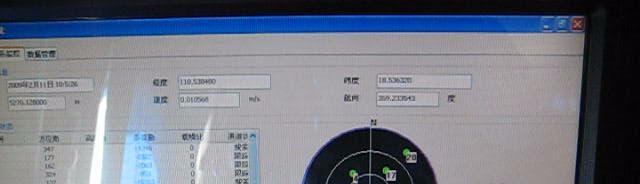

15


16 The flight information including location, satellite sky view Two dimensional reflection correlation power over time delay and Doppler -1~+3 C/A code Chip with half chip resolution Geographical User Interface -7~+7Hz Doppler with 2Hz resolution Data output is real time and dynamic, 1Hz
17 Examples for the wind retrieval Elfouhailyspectrum model was used Theory curve and test data matching method Wind speed deviation is within ±2m/s Wind direction deviation is within ±10
18 Examples for altimetry based on the collected data d h h ε S ε Geographical model for the altimetry 60 seconds data were selected Standard deviation is about 6meters Height(m)

19 3. Experiments to Significant Wave Height The GNSS-R DDMR receiver was equipped in Bohe, Guangdong province in Nov Continuously observation Data processing is ongoing


20 4. Experiments for Soil Moisture Data collection in Hailaer Neimenggu, May 2009 Experiment was performed for the land surface with and without grass Data processing results show that the GNSS reflection signal changes over the soil moisture, which has the same trend with the hygrometer
21 Guideline I. Introduction II. GNSS-R receiver Description III. Data Process and Analysis IV. Summary
22 IV. Summary Through the static and dynamic test on sea surface, soil moisture, it is shown that the collected data is effective, and the real-time output of the results can be used to retrieve various physical parameters.
23 In the design of GNSS reflected signal processing receiver, the future work will be towards multiplesystem, high-precision, high resolution and in the direction of software defined receiver. Cooperation with related organization or departments on ocean, weather and other applicationsto promotegnss-r techniquesapplication in routine observation. More applications such as surface imaging, target detection would be expanded.
24 Thank you! Dr. YANG Dongkai Professor. School of Electronic and Information Engineering, Beihang University Tel: Fax:
Remote Sensing with Reflected Signals
 Remote Sensing with Reflected Signals GNSS-R Data Processing Software and Test Analysis Dongkai Yang, Yanan Zhou, and Yan Wang (airplane) istockphoto.com/mark Evans; gpsiff background Authors from a leading
Soil Moisture Observation Utilizing Reflected GNSS Signals
 Soil Moisture Observation Utilizing Reflected GNSS Signals GNSS-R Tech in Soil Moisture New Data Processing Method Prof. Dongkai YANG Joint African/Asia-Pacific UN-Regional Centers and International Training
Prototype Software-based Receiver for Remote Sensing using Reflected GPS Signals. Dinesh Manandhar The University of Tokyo
 Prototype Software-based Receiver for Remote Sensing using Reflected GPS Signals Dinesh Manandhar The University of Tokyo dinesh@qzss.org 1 Contents Background Remote Sensing Capability System Architecture
Microwave Sensors Subgroup (MSSG) Report
 Report") Microwave Sensors Subgroup (MSSG) Report Feb 17-20, 2014, ESA ESRIN, Frascati, Italy DONG, Xiaolong, MSSG Chair National Space Science Center Chinese Academy of Sciences (MiRS,NSSC,CAS) Email: dongxiaolong@mirslab.cn
Microwave Sensors Subgroup (MSSG) Report Feb 17-20, 2014, ESA ESRIN, Frascati, Italy DONG, Xiaolong, MSSG Chair National Space Science Center Chinese Academy of Sciences (MiRS,NSSC,CAS) Email: dongxiaolong@mirslab.cn
Non-PNT Applications from GNSS. Dr. Yang Dongkai School of Electronics and Information BeiHang University
 Non-PNT Applications from GNSS Dr. Yang Dongkai edkyang@buaa.edu.cn School of Electronics and Information BeiHang University Outline 1 2 3 Introduction Typical Non-PNT Applications Potential Cooperation
GNSS Remo Sensing in ensin a 6U Cubesat
 GNSS Remote Sensing in a 6U Cubesat Andrew Dempster Remote Sensing using GNSS Radio occultation Well established, with existing missions, v useful for input to weather models Reflectometry Experimental,
Microwave Sensors Subgroup (MSSG) Report
 Report") Microwave Sensors Subgroup (MSSG) Report CEOS WGCV-35 May 13-17, 2013, Shanghai, China DONG, Xiaolong, MSSG Chair CAS Key Laboratory of Microwave Remote Sensing National Space Science Center Chinese Academy
Microwave Sensors Subgroup (MSSG) Report CEOS WGCV-35 May 13-17, 2013, Shanghai, China DONG, Xiaolong, MSSG Chair CAS Key Laboratory of Microwave Remote Sensing National Space Science Center Chinese Academy
The Typhoon Investigation using GNSS-R Interferometric Signals (TIGRIS)
") The Typhoon Investigation using GNSS-R Interferometric Signals (TIGRIS) F. Fabra 1, W. Li 2, M. Martín-Neira 3, S. Oliveras 1, A. Rius 1, W. Yang 2, D. Yang 2 and Estel Cardellach 1 1 Institute of Space
The Typhoon Investigation using GNSS-R Interferometric Signals (TIGRIS) F. Fabra 1, W. Li 2, M. Martín-Neira 3, S. Oliveras 1, A. Rius 1, W. Yang 2, D. Yang 2 and Estel Cardellach 1 1 Institute of Space
The Delay-Doppler Altimeter
 Briefing for the Coastal Altimetry Workshop The Delay-Doppler Altimeter R. K. Raney Johns Hopkins University Applied Physics Laboratory 05-07 February 2008 1 What is a Delay-Doppler altimeter? Precision
ERS-2 SAR CYCLIC REPORT
 ERS-2 SAR CYCLIC REPORT C YCLE 96 22-JUN-2004 to 27-JUL-2004 Orbit 47951 to 48452 Prepared by: PCS SAR TEAM Issue: 1.0 Reference: Date of Issue Status: Document type: Technical Note Approved by: T A B
GNSS-R for Ocean and Cryosphere Applications
 GNSS-R for Ocean and Cryosphere Applications E.Cardellach and A. Rius Institut de Ciències de l'espai (ICE/IEEC-CSIC), Spain Contents Altimetry with Global Navigation Satellite Systems: Model correlation
ERS-2 SAR CYCLIC REPORT
 ERS-2 SAR CYCLIC REPORT C YCLE 90 24-November-2003-29-December-2003 Prepared by: PCS SAR TEAM Issue: 1.0 Reference: Date of Issue Status: Document type: Technical Note Approved by: T A B L E L E O F C
A Global System for Detecting Dangerous Seas Using GNSS Bi-static Radar Technology
 A Global System for Detecting Dangerous Seas Using GNSS Bi-static Radar Technology Scott Gleason, Ka Bian, Alex da Silva Curiel Stephen Mackin and Martin Sweeting 20 th AIAA/USU Smallsat Conference, Logan,
2 INTRODUCTION TO GNSS REFLECTOMERY
 2 INTRODUCTION TO GNSS REFLECTOMERY 2.1 Introduction The use of Global Navigation Satellite Systems (GNSS) signals reflected by the sea surface for altimetry applications was first suggested by Martín-Neira
SDR D Ultra High Sensitivity Ublox 6 GPS module Super Dead Reckoning GPS Module with Gyro on Board Detect Speed by Can Bus
 SDR 4130 3D Ultra High Sensitivity Ublox 6 GPS module Super Dead Reckoning GPS Module with Gyro on Board Detect Speed by Can Bus Smart Design Technology Co., Ltd. 20F-8, No.107, Sec 1,Jhongshan Rd. Sinjhuang
GNSS Ocean Reflected Signals
 GNSS Ocean Reflected Signals Per Høeg DTU Space Technical University of Denmark Content Experimental setup Instrument Measurements and observations Spectral characteristics, analysis and retrieval method
The Case for Recording IF Data for GNSS Signal Forensic Analysis Using a SDR
 The Case for Recording IF Data for GNSS Signal Forensic Analysis Using a SDR Professor Gérard Lachapelle & Dr. Ali Broumandan PLAN Group, University of Calgary PLAN.geomatics.ucalgary.ca IGAW 2016-GNSS
Developments in GNSS Reflectometry from the SGR-ReSI on TDS-1
 Changing the economics of space Developments in GNSS Reflectometry from the SGR-ReSI on TDS-1 Martin Unwin Philip Jales, Jason Tye (SSTL), Brent Abbott SST-US Christine Gommenginger, Giuseppe Foti (NOC)
A Zeppelin-based Study on GNSS Reflectometry for Altimetric Application
 A Zeppelin-based Study on GNSS Reflectometry for Altimetric Application M. Semmling 1 G. Beyerle 1 J. Beckheinrich 1 J. Wickert 1 M. Ge 1 S. Schön 2 1 GFZ Deutsches GeoForschungsZentrum, Potsdam 2 IfE
Microwave Remote Sensing
 Provide copy on a CD of the UCAR multi-media tutorial to all in class. Assign Ch-7 and Ch-9 (for two weeks) as reading material for this class. HW#4 (Due in two weeks) Problems 1,2,3 and 4 (Chapter 7)
1.4 EVALUATION OF EXPERIMENTAL DATA FROM THE GAINS BALLOON GPS SURFACE REFLECTION INSTRUMENT
 1.4 EVALUATION OF EXPERIMENTAL DATA FROM THE GAINS BALLOON GPS SURFACE REFLECTION INSTRUMENT George G. Ganoe * NASA Langley Research Center, Hampton Virginia Thomas A. Johnson, John Ryan Somero Aerospace
GNSS-R for Land Bio-Geophysical Parameters Monitoring: the LEiMON Project
 GNSS-R for Land Bio-Geophysical Parameters Monitoring: the LEiMON Project Alejandro Egido(1), Marco Caparrini(1), Leila Guerriero(2), Nazzareno Pierdicca(2), Simonetta Paloscia(3), Marco Brogioni(3), Nicolas
Remote Sensing using Bistatic GPS and a Digital Beam Steering Receiver
 Remote Sensing using Bistatic GPS and a Digital Beam Steering Receiver Alison Brown and Ben Mathews, NAVSYS Corporation BIOGRAPHY Alison Brown is the President and Chief Executive Officer of NAVSYS Corporation.
Preparation for Flight of Next Generation Space GNSS Receivers
 Changing the economics of space Preparation for Flight of Next Generation Space GNSS Receivers ICGPSRO, 14-16 th May 2013 Taiwan #0205691 Commercial in Confidence 1 Overview SSTL and Spaceborne GNSS Small
GNSS-R for studies of the cryosphere
 GNSS-R for studies of the cryosphere F. Fabra 1, E. Cardellach 1, O. Nogués-Correig 1, S. Oliveras 1, S. Ribó 1, J.C. Arco 1, A. Rius 1, M. Belmonte-Rivas 2, M. Semmling 3, G. Macelloni 4, S. Pettinato
CYGNSS Wind Retrieval Performance
 International Ocean Vector Wind Science Team Meeting Kailua-Kona, Hawaii USA 6-8 May 2013 CYGNSS Wind Retrieval Performance Chris Ruf (1), Maria-Paola Clarizia (1,2), Andrew O Brien (3), Joel Johnson (3),
GNSS remote sensing (GNSS-RS)
") GPS Galileo GLONASS Beidou GNSS remote sensing (GNSS-RS) Shuanggen Jin ( 金双根 ) Shanghai Astronomical Observatory, CAS, Shanghai 200030, China Email: sgjin@shao.ac.cn Website: http://www.shao.ac.cn/geodesy
GPS Galileo GLONASS Beidou GNSS remote sensing (GNSS-RS) Shuanggen Jin ( 金双根 ) Shanghai Astronomical Observatory, CAS, Shanghai 200030, China Email: sgjin@shao.ac.cn Website: http://www.shao.ac.cn/geodesy
Passive Radar at home
 Passive Radar at home Electrosmog made useful Signal analysis magic with received radio signals and their reflections Martin Dudok van Heel PA1SDR@olifantasia.com http://www.olifantasia.com European USRP
Noise attenuation directly under the flight path in varying atmospheric conditions
 Noise attenuation directly under the flight path in varying atmospheric conditions S.J. Hebly 1, V. Sindhamani 2, M. Arntzen 1,2, D.H.T. Bergmans 1, and D.G. Simons 2 1 National Aerospace Laboratory Environment
Recent GNSS Reflectometry Results from the UK TDS-1 Satellite
 CHANGING THE ECONOMICS OF SPACE Recent GNSS Reflectometry Results from the UK TDS-1 Satellite Martin Unwin ICGPSRO2018, Taipei, 18-20 April 2018 SSTL 2018 Ack: SSTL, NOC, ESA, Surrey, CEOI, UKSA, InnovateUK,
3D Multi-static SAR System for Terrain Imaging Based on Indirect GPS Signals
 Journal of Global Positioning Systems (00) Vol. 1, No. 1: 34-39 3D Multi-static SA System for errain Imaging Based on Indirect GPS Signals Yonghong Li, Chris izos School of Surveying and Spatial Information
SAR Formation Flying
 3 th June 13 SAR Formation Flying Annex 4. Bistatic Sensor Experiment Document Version: v1_1 Dr. Kegen Yu, Prof. Chris Rizos & Prof. Andrew Dempster Australian Centre for Space Engineering Research (ACSER)
Scientific Applications of Fully-Focused SAR Altimetry
 Scientific Applications of Fully-Focused SAR Altimetry Alejandro Egido (1,2), Walter Smith (2) (1) UMD/CICS-MD, United States (2) NOAA, United States CICS Science Conference Nov 29, 30 & Dec 1, 2016 College
GNSS Reflectometry and Passive Radar at DLR
 ACES and FUTURE GNSS-Based EARTH OBSERVATION and NAVIGATION 26./27. May 2008, TU München Dr. Thomas Börner, Microwaves and Radar Institute, DLR Overview GNSS Reflectometry a joined proposal of DLR and
Test Results from a Novel Passive Bistatic GPS Radar Using a Phased Sensor Array
 Test Results from a Novel Passive Bistatic GPS Radar Using a Phased Sensor Array Alison Brown and Ben Mathews, NAVSYS Corporation BIOGRAPHY Alison Brown is the Chief Visionary Officer of NAVSYS Corporation.
NOAA Satellite and Information Service National Environmental Satellite, Data, and Information Service (NESDIS)
") NOAA Satellite and Information Service National Environmental Satellite, Data, and Information Service (NESDIS) Status of Current and Future Systems (NOAA-WP-33) Presentation to CGMS-40 November 2012;
NOAA Satellite and Information Service National Environmental Satellite, Data, and Information Service (NESDIS) Status of Current and Future Systems (NOAA-WP-33) Presentation to CGMS-40 November 2012;
ERS-2 SAR CYCLIC REPORT
 ERS-2 SAR CYCLIC REPORT C YCLE 101 14-DEC-2004 to 18-JAN-2005 Orbit 50456 to 50957 Prepared by: PCS SAR TEAM Issue: 1.0 Reference: Date of Issue Status: Document type: Technical Note Approved by: T A B
TanDEM-X Mission Status & Commissioning Phase Overview
 TanDEM-X Mission Status & Commissioning Phase Overview M. Zink TanDEM-X Ground Segment Manager 17-February-2011 TanDEM-X Science Team Meeting 17-Feb-2011 - OP TerraSAR-X-Add-on for Digital Elevation Measurements
Earth Remote Sensing using Surface-Reflected GNSS Signals (Part II)
") Jet Propulsion Laboratory California Institute of Technology National Aeronautics and Space Administration Jet Propulsion Laboratory California Institute of Technology Pasadena, California Earth Remote
Jet Propulsion Laboratory California Institute of Technology National Aeronautics and Space Administration Jet Propulsion Laboratory California Institute of Technology Pasadena, California Earth Remote
CNES PRIORITIES IN POLAR AND CRYOSPHERE RESEARCH
 Polar Space Task Group 3rd Session CNES PRIORITIES IN POLAR AND CRYOSPHERE RESEARCH Juliette Lambin, Steven Hosford Wednesday, May 22th, 2013 Paris, France 1 OUTLINE CNES MISSIONS FOR POLAR/CRYOSPHERE
Rec. ITU-R P RECOMMENDATION ITU-R P *
 Rec. ITU-R P.682-1 1 RECOMMENDATION ITU-R P.682-1 * PROPAGATION DATA REQUIRED FOR THE DESIGN OF EARTH-SPACE AERONAUTICAL MOBILE TELECOMMUNICATION SYSTEMS (Question ITU-R 207/3) Rec. 682-1 (1990-1992) The
OCEAN SURFACE ROUGHNESS REFLECTOMETRY WITH GPS MULTISTATIC RADAR FROM HIGH-ALTITUDE AIRCRAFT
 OCEAN SURFACE ROUGHNESS REFLECTOMETRY WITH GPS MULTISTATIC RADAR FROM HIGH-ALTITUDE AIRCRAFT VALERY U. ZAVOROTNY 1, DENNIS M. AKOS 2, HANNA MUNTZING 3 1 NOAA/Earth System Research Laboratory/ Physical
It is well known that GNSS signals
 GNSS Solutions: Multipath vs. NLOS signals GNSS Solutions is a regular column featuring questions and answers about technical aspects of GNSS. Readers are invited to send their questions to the columnist,
inter.noise 2000 The 29th International Congress and Exhibition on Noise Control Engineering August 2000, Nice, FRANCE
 Copyright SFA - InterNoise 2000 1 inter.noise 2000 The 29th International Congress and Exhibition on Noise Control Engineering 27-30 August 2000, Nice, FRANCE I-INCE Classification: 7.2 MICROPHONE ARRAY
Theoretical Simulations of GNSS Reflections from Bare and Vegetated Soils
 Theoretical Simulations of GNSS Reflections from Bare and Vegetated Soils R. Giusto 1, L. Guerriero, S. Paloscia 3, N. Pierdicca 1, A. Egido 4, N. Floury 5 1 DIET - Sapienza Univ. of Rome, Rome DISP -
Remote Sensing. Ch. 3 Microwaves (Part 1 of 2)
") Remote Sensing Ch. 3 Microwaves (Part 1 of 2) 3.1 Introduction 3.2 Radar Basics 3.3 Viewing Geometry and Spatial Resolution 3.4 Radar Image Distortions 3.1 Introduction Microwave (1cm to 1m in wavelength)
Remote Sensing Ch. 3 Microwaves (Part 1 of 2) 3.1 Introduction 3.2 Radar Basics 3.3 Viewing Geometry and Spatial Resolution 3.4 Radar Image Distortions 3.1 Introduction Microwave (1cm to 1m in wavelength)
EB-230. Ultimate TRANSYSTEM INC. EB-230 Data Sheet
 GPS Engine Board EB-230 Data Sheet EB-230 EB-230 is an ultra miniature 12 x 12 mm 2 GPS engine board. It provides superior navigation performance under dynamic conditions in areas with limited sky view
SATELLITE OCEANOGRAPHY
 SATELLITE OCEANOGRAPHY An Introduction for Oceanographers and Remote-sensing Scientists I. S. Robinson Lecturer in Physical Oceanography Department of Oceanography University of Southampton JOHN WILEY
t =1 Transmitter #2 Figure 1-1 One Way Ranging Schematic
 1.0 Introduction OpenSource GPS is open source software that runs a GPS receiver based on the Zarlink GP2015 / GP2021 front end and digital processing chipset. It is a fully functional GPS receiver which
CH GPS/GLONASS/GALILEO/SBAS Signal Simulator. General specification Version 0.2 Eng. Preliminary
 CH-380 GPS/GLONASS/GALILEO/SBAS Signal Simulator General specification Version 0.2 Eng Preliminary Phone: +7 495 665 648 Fax: +7 495 665 649 navis@navis.ru NAVIS-UKRAINE Mazura str. 4 Smela, Cherkassy
GPS software receiver implementations
 GPS software receiver implementations OLEKSIY V. KORNIYENKO AND MOHAMMAD S. SHARAWI THIS ARTICLE PRESENTS A DETAILED description of the various modules needed for the implementation of a global positioning
Active Radio Frequency Sensing for Soil Moisture Retrieval
 Active Radio Frequency Sensing for Soil Moisture Retrieval T. Pratt and Z. Lin University of Notre Dame Other Contributors L. Leo, S. Di Sabatino, E. Pardyjak Summary of DUGWAY Experimental Set-Up Deployed
IMES: The Ultimate Solution for 3-D Indoor Position
 : The Ultimate Solution for 3-D Indoor Position GNSS GNSS GNSS Dinesh Manandhar GNSS Technologies Inc., Japan 3rd Invitational Workshop on Opportunistic RF Localization for Next Generation Wireless Devices
(TPSPC) Large Current Power Inductors
 Large Current Power Inductors") Version: July 31, 2017 (TPSPC) Large Current Power Inductors Token Electronics Industry Co., Ltd. Web: www.token.com.tw Email: rfq@token.com.tw Taiwan: No.137, Sec. 1, Zhongxing Rd., Wugu District, New
Version: July 31, 2017 (TPSPC) Large Current Power Inductors Token Electronics Industry Co., Ltd. Web: www.token.com.tw Email: rfq@token.com.tw Taiwan: No.137, Sec. 1, Zhongxing Rd., Wugu District, New
High Precision GNSS in Automotive
 High Precision GNSS in Automotive Jonathan Auld, VP Engineering and Safety 6, March, 2018 2 Global OEM Positioning Solutions and Services for Land, Sea, and Air. GNSS in Automotive Today Today the primary
Validation Exercise over German Bight
 Validation Exercise over German Bight S. Dinardo 1, B. Lucas 2, L. Fenoglio 3,R. Sharoo,J. Benveniste 4 (1) SERCO/ESRIN, (2) DEIMOS/ESRIN, (3) Darmstadt University of Technology, (4) ESA/ESRIN 18/sept/2013
ABSTRACT: Three types of portable units with GNSS raw data recording capability are assessed to determine static and kinematic position accuracy
 ABSTRACT: Three types of portable units with GNSS raw data recording capability are assessed to determine static and kinematic position accuracy under various environments using alternatively their internal
The Benefits of Three Frequencies for the High Accuracy Positioning
 The Benefits of Three Frequencies for the High Accuracy Positioning Nobuaki Kubo (Tokyo University of Marine and Science Technology) Akio Yasuda (Tokyo University of Marine and Science Technology) Isao
Dave McGinnis Rich Kelley Jean Pla NESDIS spectrum manager Alion Science CNES Silver Spring, MD Suitland, MD Toulouse, FR
 Dave McGinnis Rich Kelley Jean Pla NESDIS spectrum manager Alion Science CNES Silver Spring, MD 20910 Suitland, MD 20746 Toulouse, FR New ITU R report Identification of degradation due to interference
Assessing the Feasibility of Wind Power Production for the University of Rhode Island s Bay Campus
 University of Rhode Island DigitalCommons@URI Senior Honors Projects Honors Program at the University of Rhode Island 2009 Assessing the Feasibility of Wind Power Production for the University of Rhode
A LOW-COST GNSS-R SYSTEM BASED ON SOFTWARE-DEFINED-RADIO
 A LOW-COST GNSS-R SYSTEM BASED ON SOFTWARE-DEFINED-RADIO Thomas Hobiger, Jun Amagai, Masanori Aida, Hideki Narita, and Tadahiro Gotoh (National Institute of Information and Communications Technology, Koganei,
Verification Test Plan
 (Note: the configuration data provided in this test plan is subject to change.) Antenna Verification Testing and scheduling Tel: +1 202 944 6796 Cell phone:+1 202 445 0730 Fax: +1 202 944 7000 Antenna
Design and Performance Simulation of a Ku-Band Rotating Fan-Beam Scatterometer
 Design and Performance Simulation of a Ku-Band Rotating Fan-Beam Scatterometer Xiaolong DONG, Wenming LIN, Di ZHU, (CSSAR/CAS) PO Box 8701, Beijing, 100190, China Tel: +86-10-62582841, Fax: +86-10-62528127
Assessment of HF Radar for Significant Wave Height Determination. Desmond Power VP, Remote Sensing, C-CORE
 Assessment of HF Radar for Significant Wave Height Determination Desmond Power VP, Remote Sensing, C-CORE Study Rationale Agenda Technology Overview Technology Assessment for CNLOPB Proposed Go Forward
GNSS in Remote Sensing and Earth Science
 GNSS in Remote Sensing and Earth Science James L Garrison School of Aeronau:cs and Astronau:cs Division of Environmental and Ecological Engineering School of Electrical and Computer Engineering (courtesy)
The Influence of Multipath on the Positioning Error
 The Influence of Multipath on the Positioning Error Andreas Lehner German Aerospace Center Münchnerstraße 20 D-82230 Weßling, Germany andreas.lehner@dlr.de Co-Authors: Alexander Steingaß, German Aerospace
IZT S1000 / IZT S1010 Testing ecall Systems
 IZT S1000 / IZT S1010 Testing ecall Systems Application Note Ready for the 2018 ecall standards Preinstalled scenarios for various testing Self-defined scenarios for special tests ecall and Adjacent Band
Monitoring Station for GNSS and SBAS
 Monitoring Station for GNSS and SBAS Pavel Kovář, Czech Technical University in Prague Josef Špaček, Czech Technical University in Prague Libor Seidl, Czech Technical University in Prague Pavel Puričer,
Status Report on BeiDou International Exchange and Training Center
 Status Report on BeiDou International Exchange and Training Center Associate Prof. Dr. JIN Tian Expert, BeiDou International Exchange and Training Center The UN Regional Centre (RCSSTEAP) in China Deputy
PARIS In-Orbit Demonstrator
 1/52 PARIS In-Orbit Demonstrator Manuel Martín-Neira Neira,, Salvatore D Addio,, Christopher Buck (TEC-ETP) ETP) Acknowledgments: F. Coromina (TEC-ETP) ETP) N. Floury (TEC-EEP) EEP) J. Santiago Prowald
Scatterometer Calibration. Alex Fore
 Scatterometer Calibration Alex Fore Overview Bias correction factor Antenna pattern correction Faraday Rotation correction Future work Bias Correction By comparison of our σ 0 model function to PALSAR
Airborne Experiments to study GNSS-R Phase Observations as part of the GEOHALO Mission
 Airborne Experiments to study GNSS-R Phase Observations as part of the GEOHALO Mission M. Semmling1, G. Beyerle1, J. Beckheinrich1, J. Wickert1, F. Fabra2, S. Ribó2, M. Scheinert3 GFZ 2 IEEC 3 TUD 1 Deutsches
Active and Passive Microwave Remote Sensing
 Active and Passive Microwave Remote Sensing Passive remote sensing system record EMR that was reflected (e.g., blue, green, red, and near IR) or emitted (e.g., thermal IR) from the surface of the Earth.
GNSS Reflectometry at GFZ
 GNSS Reflectometry at GFZ Achim Helm, Georg Beyerle, Ralf Stosius, Markus Rothacher (GFZ) External Partners and Contributors: Oliver Montenbruck (DLR), Estel Cardellach, Antonio Rius (IEEC), Sergei Yudanov,
Lecture 1 Introduction to Remote Sensing
 Lecture 1 Introduction to Remote Sensing Dr Ian Leiper School of Environmental and Life Sciences Bldg Purple 12.2.27 1 2 Lecture Outline Introductions Unit admin Learning outcomes Unit outline Practicals
/ PLANT SITE TAICHUNG PLANT
 / SALES SITE HEADQUARTERS / CHUNAN PLANT 35059 11 11 No.11, Ke-Yi St., Chunan, Miaoli 35059, Taiwan TEL: +886-37-585-555 FAX: +886-37-585-511 E-Mail: info@inpaq.com.tw http: //www.inpaq.com.tw http: //www.inpaqgp.com
ESA Study GNSS Reflectometry Instrument & Algorithms NCEO/CEOI Conference, 19 th Sept 2012
 Changing the economics of space ESA Study GNSS Reflectometry Instrument & Algorithms NCEO/CEOI Conference, 19 th Sept 2012 #01xxxxx Overview GNSS for Remote Sensing Concept and UK-DMC Experiment Scientific
EB-500/ EB-500L. Ultimate TRANSYSTEM INC. EB-500 Series Data Sheet
 GPS Engine Board EB-500/ EB-500L EB-500 Series Data Sheet EB-500 is an ultra miniature 13 x 15 mm2 GPS engine board. It provides superior navigation performance under dynamic conditions in areas with limited
Wave Sensing Radar and Wave Reconstruction
 Applied Physical Sciences Corp. 475 Bridge Street, Suite 100, Groton, CT 06340 (860) 448-3253 www.aphysci.com Wave Sensing Radar and Wave Reconstruction Gordon Farquharson, John Mower, and Bill Plant (APL-UW)
Improvement of Antenna System of Interferometric Microwave Imager on WCOM
 Progress In Electromagnetics Research M, Vol. 70, 33 40, 2018 Improvement of Antenna System of Interferometric Microwave Imager on WCOM Aili Zhang 1, 2, Hao Liu 1, *,XueChen 1, Lijie Niu 1, Cheng Zhang
COST Action: TU1302 Action Title: Satellite Positioning Performance Assessment for Road Transport SaPPART. STSM Scientific Report
 COST Action: TU1302 Action Title: Satellite Positioning Performance Assessment for Road Transport SaPPART STSM Scientific Report Assessing the performances of Hybrid positioning system COST STSM Reference
GNSS Reflectometry: Innovative Remote Sensing
 GNSS Reflectometry: Innovative Remote Sensing J. Beckheinrich 1, G. Beyerle 1, S. Schön 2, H. Apel 1, M. Semmling 1, J. Wickert 1 1.GFZ, German Research Center for Geosciences, Potsdam, Germany 2.Leibniz
Galileo signal reflections used for monitoring waves and weather at sea
 Press Release Monday 26 th November 2007 Galileo signal reflections used for monitoring waves and weather at sea Surrey Satellite Technology Ltd (SSTL) and the University of Surrey have succeeded for the
Microwave Remote Sensing (1)
") Microwave Remote Sensing (1) Microwave sensing encompasses both active and passive forms of remote sensing. The microwave portion of the spectrum covers the range from approximately 1cm to 1m in wavelength.
Microwave Remote Sensing (1) Microwave sensing encompasses both active and passive forms of remote sensing. The microwave portion of the spectrum covers the range from approximately 1cm to 1m in wavelength.
PAU-SARA: a L1-GPS Band Radiometer and Reflectometer with Digital Beamforming and Polarization Synthesis
 PAU-SARA: a L1-GPS Band Radiometer and Reflectometer with Digital Beamforming and Polarization Synthesis X. Bosch-Lluis, N. Rodríguez-Álvarez, A. Camps, E. Valencia, I. Ramos-Perez, H. Park. Remote Sensing
China. France Oceanography S A T. Overview of the near-real time wave products of the CFOSAT mission. e l l i t e
 China Overview of the near-real time wave products of the CFOSAT mission C. Tison (1), D. Hauser (2), S. Guibert (1), T. Amiot (1), L. Aouf (3), J.M. Lefèvre (3), B. Chapron (5), N. Corcoral (1), P. Castillan
Experiences in. Flight Inspecting GBAS
 Experiences in Flight Inspecting GBAS Thorsten Heinke Aerodata AG 1 Flight Inspection of GBAS Overview Basics Requirements Equipment Flight Inspection 2 Ground Based Augmentation System VDB Tx-Frequency
GNSS Reflections over Ocean Surfaces
 GNSS Reflections over Ocean Surfaces State of the Art F. Soulat CCT Space Reflectometry December 1st 2010 Page n 1 Outline Concept GNSS-R Signal On-going Activities ( Applications) CLS GNSS-R Studies CCT
EE 529 Remote Sensing Techniques. Introduction
 EE 529 Remote Sensing Techniques Introduction Course Contents Radar Imaging Sensors Imaging Sensors Imaging Algorithms Imaging Algorithms Course Contents (Cont( Cont d) Simulated Raw Data y r Processing
Security of Global Navigation Satellite Systems (GNSS) GPS Fundamentals GPS Signal Spoofing Attack Spoofing Detection Techniques
 GPS Fundamentals GPS Signal Spoofing Attack Spoofing Detection Techniques") Security of Global Navigation Satellite Systems (GNSS) GPS Fundamentals GPS Signal Spoofing Attack Spoofing Detection Techniques Global Navigation Satellite Systems (GNSS) Umbrella term for navigation
Security of Global Navigation Satellite Systems (GNSS) GPS Fundamentals GPS Signal Spoofing Attack Spoofing Detection Techniques Global Navigation Satellite Systems (GNSS) Umbrella term for navigation
Acquisition and Tracking of IRNSS Receiver on MATLAB and Xilinx
 Acquisition and Tracking of IRNSS Receiver on MATLAB and Xilinx Kishan Y. Rathod 1, Dr. Rajendra D. Patel 2, Amit Chorasiya 3 1 M.E Student / Marwadi Education Foundation s Groups of Institute 2 Accociat
Detecting Ionospheric TEC Perturbations Generated by Natural Hazards Using a Real-Time Network of GPS Receivers
 Detecting Ionospheric TEC Perturbations Generated by Natural Hazards Using a Real-Time Network of GPS Receivers Attila Komjathy, Yu-Ming Yang, and Anthony J. Mannucci Jet Propulsion Laboratory California
GPS Accuracy in Urban Environments Using Post-Processed CORS Data
 GPS Accuracy in Urban Environments Using Post-Processed CORS Data Knute A. Berstis, Gerald L. Mader NOAA, NOS, National Geodetic Survey Silver Spring, MD Aaron Jensen US Census Bureau Washington, DC Presentation
Fugro Marinestar Improvements
 Fugro Marinestar Improvements Hans Visser Fugro Intersite B.V. Improvements in Marinestar Positioning Hydro 2016 Warnemünde, 10 November 2016 Overview of presentation The Marinestar GNSS Networks The supplied
PARIS Ocean Altimeter
 PARIS Ocean Altimeter M. Martín-Neira, S. D Addio (TEC-ETP) European Space Agency Acknowledgment: C. Buck (TEC-ETP) N. Floury, R. Prieto (TEC-EEP) GNSS-R10 Workshop, UPC, Barcelona, 21-22 October 2010
A SYSTEM FOR THE ADVANCE WARNING OF RISK OF LIGHTNING. John Chubb and John Harbour
 A SYSTEM FOR THE ADVANCE WARNING OF RISK OF LIGHTNING John Chubb and John Harbour John Chubb Instrumentation, Unit 30, Lansdown Industrial Estate, Gloucester Road, Cheltenham, GL51 8PL, UK. (Tel: +44 (0)1242
OBSERVATION PERFORMANCE OF A PARIS ALTIMETER IN-ORBIT DEMONSTRATOR
 OBSERVATION PERFORMANCE OF A PARIS ALTIMETER IN-ORBIT DEMONSTRATOR Salvatore D Addio, Manuel Martin-Neira Acknowledgment to: Nicolas Floury, Roberto Pietro Cerdeira TEC-ETP, ETP, Electrical Engineering
AIRPORT MULTIPATH SIMULATION AND MEASUREMENT TOOL FOR SITING DGPS REFERENCE STATIONS
 AIRPORT MULTIPATH SIMULATION AND MEASUREMENT TOOL FOR SITING DGPS REFERENCE STATIONS ABSTRACT Christophe MACABIAU, Benoît ROTURIER CNS Research Laboratory of the ENAC, ENAC, 7 avenue Edouard Belin, BP
On the Achievable Accuracy for Estimating the Ocean Surface Roughness using Multi-GPS Bistatic Radar
 On the Achievable Accuracy for Estimating the Ocean Surface Roughness using Multi-GPS Bistatic Radar Nima Alam, Kegen Yu, Andrew G. Dempster Australian Centre for Space Engineering Research (ACSER) University
Ship-based Oceanwide Observation of Sea Surface Heights in Consideration of Hydrodynamic Corrections
 Ship-based Oceanwide Observation of Sea Surface Heights in Consideration of Hydrodynamic Corrections Jörg Reinking, Alexander Härting XXV FIG Congress 2014, Kuala Lumpur, 16-21 June 2014 MOTIVATION Sea