GROUND PENETRATING RADAR AND THE SURVEYOR w/ Case Studies
|
|
|
- Candice Newton
- 5 years ago
- Views:
Transcription


1 GROUND PENETRATING RADAR AND THE SURVEYOR w/ Case Studies Joseph D. Fenicle, PS Ohio & Michigan Professional Surveyor Office of the Fulton County Engineer Wauseon, Ohio Angular By Nature, LLC Adrian, MI POB - Point of Beginning April 2009 Article POB - Point of Beginning April 2009 Article 1


2 POB - Point of Beginning April 2009 Article GPR John Kessinger, Regional Director Ground Penetrating Radar Systems, Inc. Sylvania, OH Michael Friedhoff, Project Geologist Mannik Smith Group, Inc. Canton, MI 2
3 What is GPR? GPR works by sending a tiny pulse of energy into a material and recording the strength and the time required for the return of any reflected signal. A series of pulses over a single area make up what is called a scan. Reflections are produced whenever the energy pulse enters into a material with different electrical conduction properties or dielectric permittivity from the material it left. What GPR is not! Radiography (X-Ray Technology) Metal Detector Gradiometer Acoustic Technology New Technology (i.e. Spar Utility Locator) What GPR is not! Radiography (X-Ray Technology) Metal Detector Gradiometer Acoustic Technology New Technology (i.e. Spar Utility Locator) Curb Box Charger 3
 Metal Detector Gradiometer Acoustic Technology New Technology (i.e. Spar Utility Locator) Curb Box Charger What GPR is not!")
4 What GPR is not! Radiography (X-Ray Technology) Metal Detector Gradiometer Acoustic Technology New Technology (i.e. Spar Utility Locator) Curb Box Charger What GPR is not! Radiography (X-Ray Technology) Metal Detector Gradiometer Acoustic Technology New Technology (i.e. Spar Utility Locator) Curb Box Charger What GPR is not! Radiography (X-Ray Technology) Radiography uses a very small dose of ionizing radiation to produce pictures of the body s internal structures. 4
 Metal Detector Gradiometer Acoustic Technology New Technology (i.e. Spar Utility Locator) Curb Box Charger 5")
5 What GPR is not! Radiography (X-Ray Technology) Metal Detector Gradiometer Acoustic Technology New Technology (i.e. Spar Utility Locator) Curb Box Charger Metal Detector What GPR is not! Metal Detectors detect the presence of metal nearby. What GPR is not! Radiography (X-Ray Technology) Metal Detector Gradiometer Acoustic Technology New Technology (i.e. Spar Utility Locator) Curb Box Charger 5
 Metal Detector Gradiometer Acoustic Technology New Technology (i.e. Spar Utility Locator) Curb Box Charger What GPR is not!")
6 Gradiometer What GPR is not! A gradiometer is an instrument for measuring the gradient of an energy field, especially the horizontal gradient of the earth s gravitational magnetic field. What GPR is not! Radiography (X-Ray Technology) Metal Detector Gradiometer Acoustic Technology New Technology (i.e. Spar Utility Locator) Curb Box Charger What GPR is not! Acoustic Technology Acoustic Technology is the science of using sound to determine the distance and direction of its source. 6
 Met")
7 What GPR is not! Radiography (X-Ray Technology) Metal Detector Gradiometer Acoustic Technology New Technology (i.e. Spar Utility Locator) Curb Box Charger What GPR is not! New Technology (i.e. Spar Utility Locator) According to Optical Ranging the technology is based on the optimization of data from many sensors against a physical model of the magnetic field expected from a utility line. What GPR is not! Radiography (X-Ray Technology) Metal Detector Gradiometer Acoustic Technology New Technology (i.e. Spar Utility Locator) Curb Box Charger 7


8 What GPR is not! Curb Box Charger The Curb Box Charger simply puts a magnetic charge on ferrous metal objects. How Does GPR Work? Antenna Control Unit Power Supply 8
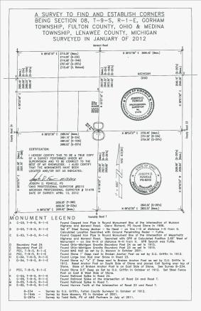
9 Antenna How Does GPR Work? The antenna receives the electrical pulse produced by the control unit, amplifies it and transmits it into the ground or other medium at a particular frequency. Antenna frequency is one major factor in depth penetration. The higher the frequency of the antenna, the shallower into the ground it will penetrate. A higher frequency antenna will also see smaller targets. Antenna choice is one of the most important factors in survey design How Does GPR Work? Control Unit The control unit contains the electronics which triggers the pulse of radar energy that the antenna sends into the ground. It also has a built-in computer and hard disk/solid state memory to store data for examination after fieldwork. How Does GPR Work? Power Supply GPR equipment can be run with a variety of power supplies ranging from small rechargeable batteries to vehicle batteries and normal 110/220-volt. Connectors and adapters are available for each power source type. 9

10 How Does GPR Work? GPR operates much like a sophisticated and superexpensive fish finder. POB April 2009 How Does GPR Work? How Deep Does GPR Work? 10


11 How Deep Does GPR Work? How Deep Does GPR Work? How Deep Does GPR Work? 11


12 How Deep Does GPR Work? How Deep Does GPR Work? How Deep Does GPR Work? 12

13 How Deep Does GPR Work? 13
14 14

15 Ground-penetrating radar (GPR) is a geophysical method that is often mentioned in news commentaries for its use in locating unmarked graves, clandestine burials and tunnels, terrorism and military hazards, and disaster victims. However, the effectiveness of GPR in these activities is highly site-specific and soil dependent. A common concern of GPR service providers is whether or not GPR will be able to achieve the desired depth of penetration in the soils of an assignment area. In many soils, high rates of signal attenuation severely restrict penetration depths and limit the suitability of GPR for a large number of applications. Knowledge of the probable penetration depth and relative suitability of soils can help service providers assess the appropriateness of using GPR and the likelihood of achieving acceptable results. Soil attribute data contained in the State Soil Geographic (STATSGO) and the Soil Survey Geographic (SSURGO) databases have been used to develop thematic maps showing, at different scales and levels of resolution, the relative suitability of soils for many GPR applications. 15


16 16


17 Why Use GPR? 17


18 Why Use GPR? Why Use GPR(for surveying)? WHAT LIES BENEATH 18
19 Why Use GPR(for surveying)? Why Use GPR(for surveying)? When a corner is positioned in accordance with the lost corner theory of proportioning, the surveyor must be convinced that no future surveyor or court will be able to locate the original corner in a different place. Proportionate measurement is always a rule of last resort. Walt Robillard, et al. Brown s Boundary Control & Legal Principles 19


20 B. Description of corner evidence found and/or method applied in restoring or re-establishing corner. October 11, I traversed to tie together existing monumentation in 4 cardinal directions from this corner from A-12, T5S, R6E to M-3, T6S, R5E on the Range Line, as well as L-13, T5S, R5W and B-1, T6S, R6E. The Baldwin survey notes 3 plow points and 2 stones between A-1 and A-3. Warnke recovered the 3 plow points in Using the angles and chainage of the Baldwin survey with the recovered points, I proportioned several positions to look for the stone at this corner, as well as the stone ¼ mile south. With Glenn Richard s help, we drilled thru the pavement in approximately 30 locations to a depth of 18 and probed to about 40. We also checked on the occupied line ¼ mile south of this corner in the middle of the pavement. We also checked around the Marino corner. We did not find any evidence worthy of proceeding to excavate thru the asphalt. Using the data I obtained, as well as traverse work done by Richard and Warnke in Section 6, T6S, R6E, and monumentation found by Warnke from the 1890 Baldwin survey, it is clear there are inconsistencies between the Baldwin survey, the road survey, and measured distances between found monumentation and this corner is considered lost. The position determined by double proportionate measurement would best fit the pipe as set by Glenn Richard in December 1, 2011 at 2 depth, found a 1 O.D. iron pipe, being 18 ½ in length. Found no further evidence. I accept the position of the iron pipe as set by Richard in 1974 as the best available evidence of the position of the original corner. Set a 5/8 by 36 rebar in place of the pipe in a set monument box. Courtesy of: Consumers Energy, Jackson, MI - Phil Norder, PS GPR Case Studies 20
21 21


22 22

23 23


24 24
25 25

26 26

27 27


28 28

29 Thank You - Questions 29
Report. Mearns Consulting LLC. Former Gas Station 237 E. Las Tunas Drive San Gabriel, California Project # E
 Mearns Consulting LLC Report Former Gas Station 237 E. Las Tunas Drive San Gabriel, California Project #1705261E Charles Carter California Professional Geophysicist 20434 Corisco Street Chatsworth, CA
Archaeo-Geophysical Associates, LLC
 Geophysical Survey at the Parker Cemetery Rockwall, Texas. AGA Report 2010-6 Report Submitted To: Texas Cemetery Restoration 10122 Cherry Tree Dr. Dallas, Texas 75243 May 14, 2010 Chester P. Walker, Ph.D.
A Report on the Ground Penetrating Radar Survey 205 Little Plains Road Southampton, NY
 A Report on the Ground Penetrating Radar Survey 205 Little Plains Road Southampton, NY November 18, 2016 Conducted by Robert W. Perry TOPOGRAPHIX, LLC Hudson, NH Requested by Southampton Town Historical
Utility Locating Terminology & Equipment Guide. Utility Survey Corp.
 Utility Locating Terminology & Equipment Guide Utility Survey Corp. Contents Utility Locating Terminology Utility Locating Toning or Scoping Scanning X Ray the Ground & Ground Penetrating Radar 3 4 5 6
SURVEYING THE UNDERGROUND
 SURVEYING THE UNDERGROUND An Introduction to ASCE 38-02 and the Practice of Subsurface Utility Engineering ACECMD March 28, 2018 Presented by: Art Worthman A. Morton Thomas & Associates, Inc. John Berrettini
STATE UNIVERSITY CONSTRUCTION FUND
 DIRECTIVE 1C-12 Issue date: August 2012 1. General SURVEY, MAPPING AND UTILITY LOCATING This Directive has been developed as a general guide for the survey and mapping effort required for Fund projects.
In search of a Historic Grave: GPR Investigation near the Yellowstone Lake Store: 7/15/2010
 In search of a Historic Grave: GPR Investigation near the Yellowstone Lake Store: 7/15/2010 Steven Sheriff Professor of Geophysics Department of Geosciences University of Montana Missoula, Montana Introduction
L O C A T O R G P R. Introducing the. Radarteam. Ground Probing Radar/Antenna system with Rugged PC and Cart ü
 Introducing the L O C A T O R G P R Ground Probing Radar/Antenna system with Rugged PC and Cart ü Fully integrated system. Multi Frequency operation: 100-900 MHz ü Air/Ground Coupled operation. Multiple
RD1000 Ground Probing Radar
 RD1000 Ground Probing Radar CONTENTS Product Introduction Product Features Competitor Analysis Customers Models, Pricing & Availability Promotional Material Practical Demonstration What to do now Summary
7. Consider the following common offset gather collected with GPR.
 Questions: GPR 1. Which of the following statements is incorrect when considering skin depth in GPR a. Skin depth is the distance at which the signal amplitude has decreased by a factor of 1/e b. Skin
Estimation results on the location error when using cable locator
 Estimation results on the location error when using cable locator HITOSHI KIJIMA TOMOHIKO HATTORI Tokaigakuin University 5-68 Naka Kirino Kagamigahara, Gifu 504-8511 JAPAN kijima@tokaigakuin-u.ac.jp, t.hattori@tokaigakuin-u.ac.jp
Ground Penetrating Radar (GPR) By Dr. Eng. Zubair Ahmed
 By Dr. Eng. Zubair Ahmed") Ground Penetrating Radar (GPR) By Dr. Eng. Zubair Ahmed Acknowledgement Golder Associates, Whitby, Ontario Stantec Consulting, Kitchener, Ontario Infrasense Inc. USA Geophysical Survey Systems Inc. (GSSI),
Ground Penetrating Radar (GPR) By Dr. Eng. Zubair Ahmed Acknowledgement Golder Associates, Whitby, Ontario Stantec Consulting, Kitchener, Ontario Infrasense Inc. USA Geophysical Survey Systems Inc. (GSSI),
HGD HURRICANE 2010 / 2011
 HGD HURRICANE 2010 / 2011 The Global Surprise For the Treasures Hunters, Prospecting Amateurs, for all Researchers for Gold and Underground Metals Introduction: The Modern scientific Innovation, Exclusive
Ground Penetrating Radar
 Ground Penetrating Radar Begin a new section: Electromagnetics First EM survey: GPR (Ground Penetrating Radar) Physical Property: Dielectric constant Electrical Permittivity EOSC 350 06 Slide Di-electric
# DEFINITIONS TERMS. 2) Electrical energy that has escaped into free space. Electromagnetic wave
 Electrical energy that has escaped into free space. Electromagnetic wave") CHAPTER 14 ELECTROMAGNETIC WAVE PROPAGATION # DEFINITIONS TERMS 1) Propagation of electromagnetic waves often called radio-frequency (RF) propagation or simply radio propagation. Free-space 2) Electrical
CHAPTER 14 ELECTROMAGNETIC WAVE PROPAGATION # DEFINITIONS TERMS 1) Propagation of electromagnetic waves often called radio-frequency (RF) propagation or simply radio propagation. Free-space 2) Electrical
GPR SYSTEM USER GUIDE AND TROUBLESHOOTING GUIDE
 GPR SYSTEM USER GUIDE AND TROUBLESHOOTING GUIDE Implementation Report 5-4414-01-1 Project Number 5-4414-01 Subsurface Sensing Lab Electrical and Computer Engineering University of Houston 4800 Calhoun
SIMULATION OF GPR SCENARIOS USING FDTD
 SIMULATION OF GPR SCENARIOS USING FDTD 1 GAMIL ALSHARAHI, 2 ABDELLAH DRIOUACH, 3 AHMED FAIZE 1,2 Department of physic, Abdelmalek Essaâdi University, Faculty of sciences, Morocco 3 Department of physic,
1. Report No. FHWA/TX-05/ Title and Subtitle PILOT IMPLEMENTATION OF CONCRETE PAVEMENT THICKNESS GPR
 1. Report No. FHWA/TX-05/5-4414-01-3 4. Title and Subtitle PILOT IMPLEMENTATION OF CONCRETE PAVEMENT THICKNESS GPR Technical Report Documentation Page 2. Government Accession No. 3. Recipient s Catalog
GPR SURVEY METHOD. Ground probing radar
 The ground penetrating radar (GPR - Ground Probing Radar) is a geophysical method used to investigate the near surface underground. Thanks to its high degree of resolution, the GPR is the most effective
VALIDATION OF GROUND PENETRATING RADAR DATA INTERPRETATION USING AN ELECTROMAGNETIC WAVE PROPAGATION SIMULATOR
 Romanian Reports in Physics, Vol. 68, No. 4, P. 1584 1588, 2016 VALIDATION OF GROUND PENETRATING RADAR DATA INTERPRETATION USING AN ELECTROMAGNETIC WAVE PROPAGATION SIMULATOR A. CHELMUS National Institute
Ground Penetrating Radar (day 1) EOSC Slide 1
 EOSC Slide 1") Ground Penetrating Radar (day 1) Slide 1 Introduction to GPR Today s Topics Setup: Motivational Problems Physical Properties - Dielectric Permittivity and Radiowaves - Microwave Example Basic Principles:
Ground Penetrating Radar (day 1) Slide 1 Introduction to GPR Today s Topics Setup: Motivational Problems Physical Properties - Dielectric Permittivity and Radiowaves - Microwave Example Basic Principles:
SIR, RADAN and UtilityScan are registered trademarks of Geophysical Survey Systems, Inc..
 Copyright 2001-2017 Geophysical Survey Systems, Inc. All rights reserved including the right of reproduction in whole or in part in any form Published by Geophysical Survey Systems, Inc. 40 Simon Street
3D UTILITY MAPPING USING ELECTRONICALLY SCANNED ANTENNA ARRAY. Egil S. Eide and Jens F. Hjelmstad
 D UTILITY MAPPING USING ELECTRONICALLY SCANNED ANTENNA ARRAY Egil S. Eide and Jens F. Hjelmstad Department of Telecommunications Norwegian University of Science and Technology, N-79 Trondheim, Norway eide@tele.ntnu.no
GPR Investigation: Post Tension Cable Mapping
 CMD Civil Pty Ltd PO Box 1119 Huntingdale VIC 3166 +61 3 9544 8833 info@cmdcivil.com www.cmdcivil.com Case Study: GPR Investigation: Post Tension Cable Mapping This application note demonstrates an example
Dr. William Whitsitt President Domestic Petroleum Council. Advances in Technology: Innovations in the Domestic Energy and Mineral Sector
 Statement of Dr. William Whitsitt President Domestic Petroleum Council on behalf of American Petroleum Institute Domestic Petroleum Council Independent Petroleum Association of America International Association
COBRA CBD UNPARALLELED QUALITY GPR DATA WITHOUT BLIND SPOTS
 COBRA CBD WIRELESS GPR Introducing the smart CBD ANTENNA Triple frequency 200/400/800 MHz Outstanding 50-1400 MHz bandwidth Replaces several conventional antennas UNPARALLELED QUALITY GPR DATA WITHOUT
a step change in Ground Penetrating Radar technology Guido Manacorda Engineering Manager
 The ORFEUS Project: a step change in Ground Penetrating Radar technology to locate buried utilities Guido Manacorda Engineering Manager IDS Ingegneria dei Sistemi i SpA Key issues Many ypp pipes and cables
GeoRadar Division. GPR for Archeology and Cultural Heritage. GeoRadar Division. GPR Configuration for Archeology and Cultural Heritage Application
 GeoRadar Division GPR Configuration for Archeology and Cultural Heritage Application We believe that the Archaeological patrimony and the Cultural Heritage are one of the most important aspect of this
2.000 M LONG DISTANCE GOLD SCANNER AND FINDER COBRA LRL DETECTOR USER S GUIDE SEARCH OPTIONS IN 6 LANGUAGES AND 5 DIFFERENT FREQUENCIES
 2.000 M LONG DISTANCE GOLD SCANNER AND FINDER COBRA LRL DETECTOR USER S GUIDE SEARCH OPTIONS IN 6 LANGUAGES AND 5 DIFFERENT FREQUENCIES SEARCH MODES Gold Silver Bronze Copper Iron Water Cave Tunnel LANGUAGE
APPLICATION FOR PERMIT TO RELOCATE THE WADSWORTH - CLAYTON CEMETERY LAMAR COUNTY, GEORGIA
 APPLICATION FOR PERMIT TO RELOCATE THE WADSWORTH - CLAYTON CEMETERY LAMAR COUNTY, GEORGIA SUBMITTED TO: Lamar County Board of Commissioners 408 Thomaston Street, Suite E Barnesville, Georgia 30204 SUBMITTED
HAZARDS OF ELECTROMAGNETIC RADIATION TO ORDNANCE (HERO) CONCERNS DURING UXO LOCATION/REMEDIATION
 CONCERNS DURING UXO LOCATION/REMEDIATION") HAZARDS OF ELECTROMAGNETIC RADIATION TO ORDNANCE (HERO) CONCERNS DURING UXO LOCATION/REMEDIATION Kurt E. Mikoleit Naval Surface Warfare Center, Dahlgren Division Dahlgren, Virginia ABSTRACT: As part of
HAZARDS OF ELECTROMAGNETIC RADIATION TO ORDNANCE (HERO) CONCERNS DURING UXO LOCATION/REMEDIATION Kurt E. Mikoleit Naval Surface Warfare Center, Dahlgren Division Dahlgren, Virginia ABSTRACT: As part of
Applied Geophysics Nov 2 and 4
 Applied Geophysics Nov 2 and 4 Effects of conductivity Surveying geometries Noise in GPR data Summary notes with essential equations Some Case histories EOSC 350 06 Slide 1 GPR Ground Penetrating Radar
Advances in NDE Technology WHATS NEW?
 Advances in NDE Technology WHATS NEW? Glen Simula, Owner GS Infrastructure, Inc. The state of America s deteriorating infrastructure presses us to find solutions to assess, with limited funds and resources.
Metal Detector Description
 Metal Detector Description A typical metal detector used for detecting buried coins, gold, or landmines consists of a circular horizontal coil assembly held just above the ground. A pulsed or alternating
Pitfalls in GPR Data Interpretation: Differentiating Stratigraphy and Buried Objects from Periodic Antenna and Target Effects
 GEOPHYSICAL RESEARCH LETTERS, VOL. 27, NO. 20, PAGES 3393-3396, OCTOBER 15, 2000 Pitfalls in GPR Data Interpretation: Differentiating Stratigraphy and Buried Objects from Periodic Antenna and Target Effects
November 13, Hindu Temple, LTD Arbor Street Omaha, Nebraska Attn: Subject:
 November 13, 2017 Hindu Temple, LTD 13010 Arbor Street Omaha, Nebraska 68144-0000 Attn: Subject: Srini Mallipudi / mallipudis@gmail.com Underground Utility Survey Report Hindu Temple - 13010 Arbor Street,
The use of high frequency transducers, MHz, allowing the resolution to target a few cm thick in the first half meter suspect.
 METHODOLOGY GPR (GROUND PROBING RADAR). In recent years the methodology GPR (Ground Probing Radar) has been applied with increasing success under the NDT thanks to the high speed and resolving power. As
Dowel Alignment: Measurement and Impacts on Pavement Performance
 Dowel Alignment: Measurement and Impacts on Pavement Performance prepared by: Mark B. Snyder, Ph.D., P.E. Vice-President, ACPA-PA Chapter for: ACPA s 2012 Annual Meeting Concrete Pavement University November
ARCHAEOLOGICAL GEOPHYSICS: SENSOR SELECTION AND SITE SUITABILITY
 ARCHAEOLOGICAL GEOPHYSICS: SENSOR SELECTION AND SITE SUITABILITY A SPARC Webinar presented on October 17, 2014 Eileen G. Ernenwein, PhD ETSU: http://faculty.etsu.edu/ernenwei/ CAST: http://goo.gl/wyzlp
Advanced Utility Locating Technologies (R01B)
") Advanced Utility Locating Technologies (R01B) Jacob Sheehan Senior Geophysicist Olson Engineering Phil Sirles Principal Geophysicist Olson Engineering Introduction: Utility Bundle Overview SHRP2 Strategic
Advanced Utility Locating Technologies (R01B) Jacob Sheehan Senior Geophysicist Olson Engineering Phil Sirles Principal Geophysicist Olson Engineering Introduction: Utility Bundle Overview SHRP2 Strategic
BAINBRIDGE VILLAGE GREEN & QUAKER FIELD
 BAINBRIDGE VILLAGE GREEN & QUAKER FIELD GEOPHYSICAL SURVEY September 2017 Contents 1. Introduction 2. Equipment and Methodology 3. Location 4. Description of Sites 5. Results and Discussion - General 6.
Assessment of layer thickness and uniformity in railway embankments with Ground Penetrating Radar
 Assessment of layer thickness and uniformity in railway embankments with Ground Penetrating Radar F.M. Fernandes Department of Civil Engineering, University of Minho, Guimarães, Portugal M. Pereira Geotechnique
Ground Penetrating Radar
 REPORT 4A Ground Penetrating Radar Introduction to GPR, and positioning of GPR data Part of R&D project Infrastructure in 3D in cooperation between Innovation Norway, Trafikverket and TerraTec Yta för
AGENDA Cemetery Board 206 Toronto St. S., Markdale, Ontario June 11, :00 p.m.
 AGENDA Cemetery Board 206 Toronto St. S., Markdale, Ontario June 11, 2008-4:00 p.m. Page 1. CALL TO ORDER 2. ADDITIONS TO OR DELETIONS FROM THE AGENDA 3. ADOPTION OF AGENDA 4. DECLARATION OF CONFLICT OR
DOUBLE PROPORTION MADE COMPLEX
 DOUBLE PROPORTION MADE COMPLEX Jerry L. Wahl Branch of Cadastral Surveys Bureau of Land Management California State Office 2800 Cottage Way, E-2841 Sacramento, California 95825 ABSTRACT Our ever increasing
SPECIAL SPECIFICATION 1257 Digital Card Rack Non-Invasive Micro Loop Detector Assembly (8 Slot Rack)
") 1993 Specifications CSJ 0924-06-147, etc. SPECIAL SPECIFICATION 1257 Digital Card Rack Non-Invasive Micro Loop Detector Assembly (8 Slot Rack) 1. Description. This Item shall govern for furnishing, and
1993 Specifications CSJ 0924-06-147, etc. SPECIAL SPECIFICATION 1257 Digital Card Rack Non-Invasive Micro Loop Detector Assembly (8 Slot Rack) 1. Description. This Item shall govern for furnishing, and
ωκε ωκε 5.11 Ground Penetrating Radar (GPR)
") 5. Ground Penetrating Radar (GPR) The plane wave solutions we have studied so far have been valid for frequencies and conductivities such that the conduction currents dominate the displacement currents
5. Ground Penetrating Radar (GPR) The plane wave solutions we have studied so far have been valid for frequencies and conductivities such that the conduction currents dominate the displacement currents
RADAR INSPECTION OF CONCRETE, BRICK AND MASONRY STRUCTURES
 RADAR INSPECTION OF CONCRETE, BRICK AND MASONRY STRUCTURES C.P.Hobbs AEA Industrial Technology Materials and Manufacturing Division Nondestructive Testing Department Building 447 Harwell Laboratory Oxon
Using ground penetrating radar to quantify changes in the fracture pattern associated with a simulated rockburst experiment
 Using ground penetrating radar to quantify changes in the fracture pattern associated with a simulated rockburst experiment by M. Grodner* Synopsis Ground Penetrating Radar (GPR) is an electromagnetic
Operation Manual for CTL-3000
 CATH-TECH CORROSION CONTROL EQUIPMENT Operation Manual for CTL-3000 DCVG Survey Instrument Cathodic Technology Ltd. 15-1 Marconi Court Bolton, Ontario Canada L7E 1E2 Ph: ++1-905-857-1050 ctl@cath-tech.com
SEISMIC, ACOUSTIC, AND MAGNETIC TEST RESULTS FROM US/GERMAN TESTING
 Approved for public release; distribution is unlimited. SEISMIC, ACOUSTIC, AND MAGNETIC TEST RESULTS FROM US/GERMAN TESTING John Sledge CHICKEN LITTLE Program Office Eglin AFB Florida 32542 ABSTRACT Seismic,
Geophysical Survey Rock Hill Bleachery TBA Site Rock Hill, South Carolina EP-W EPA, START 3, Region 4 TABLE OF CONTENTS Section Page Signature
 Geophysical Survey Rock Hill Bleachery TBA Site Rock Hill, South Carolina EP-W-05-054 EPA, START 3, Region 4 Prepared for: Tetra Tech EM, Inc. October 12, 2012 Geophysical Survey Rock Hill Bleachery TBA
Using GPR Technique Assessment for Study the Sub-Grade of Asphalt and Concrete Conditions
 Using GPR Technique Assessment for Study the Sub-Grade of Asphalt and Concrete Conditions Alaa S. Mahdi Remote Sensing Unit, College of Science, University of Baghdad, Baghdad, Iraq Abstract The Ground
Electronic Pipeline Technology
 Pipe and Cable Locator Pearson Holiday Detector Model EPT- 1000 Electronic Pipeline Technology Electronic Pipeline Technology 26 Palomino Drive, Richmond Hill, Ontario, Canada, L4C 0P8 Tel: (905) 918-0025
CONTENTS. Accessories and Components System Unit and Joystick Assembly and Charging the Battery Jeotech Using Phases...
 CONTENTS Accessories and Components... 3 System Unit and Joystick... 4 Assembly and Charging the Battery... 6 Jeotech Using Phases... 9 What is ground setting and how it is done?... 11 Steps for the Ground
Advanced Ground Investigation Techniques to Help Limit Risk or Examine Failure. Advanced Subsurface Investigations
 Advanced Ground Investigation Techniques to Help Limit Risk or Examine Failure Overview Introduction What is geophysics? Why use it? Common Methods Seismic Ground Radar Electrical Case Studies Conclusion
Strategic City Wide Mapping of Underground Assets using Ground Penetrating Radar. Mark Bell
 Strategic City Wide Mapping of Underground Assets using Ground Penetrating Radar Mark Bell XXV International Federation of Surveyors Congress, Kuala Lumpur, Malaysia, 16 21 June 2014 TOPICS GPR background
INDEX. Accessories and Components System Unit and Joystick Assembly and Charging the Battery Using with LED System...
 USER GUIDE INDEX Accessories and Components... 4 System Unit and Joystick... 6 Assembly and Charging the Battery... 9 Using with LED System... 11 What is Ground Setting and How It Is Done... 14 Ground
Technician License Course Chapter 4. Lesson Plan Module 9 Antenna Fundamentals, Feed Lines & SWR
 Technician License Course Chapter 4 Lesson Plan Module 9 Antenna Fundamentals, Feed Lines & SWR The Antenna System Antenna: Transforms current into radio waves (transmit) and vice versa (receive). Feed
THE BEST GPR DATA QUALITY AT THE BEST PRICE! GROUND PENETRATING RADAR ZOND-12e G R O U N D P E N E T R A T I N G R A D A R S
 GROUND PENETRATING RADAR ZOND-12e General Purpose Pulse GPR ZOND-12e SINGLE CHANNEL OR ADVANCED CONTROL UNITS ZOND 12e GPR is a portable digital Ground Penetrating Radar carried by a single operator. The
Survey Sensors. 18/04/2018 Danny Wake Group Surveyor i-tech Services
 Survey Sensors 18/04/2018 Danny Wake Group Surveyor i-tech Services What do we need sensors for? For pure hydrographic surveying: Depth measurements Hazard identification Seabed composition Tides & currents
CHAPTER F IVE ROBOTIC TOTAL STATION
 CHAPTER F IVE ROBOTIC TOTAL STATION 5 ROBOTIC TOTAL STATION 5 OVERVIEW If necessity is the mother of invention, then the invention of the Total Station robotic instrument truly fits the requirements of
SURVEYING THE UNDERGROUND
 SURVEYING THE UNDERGROUND An Introduction to the Practice of Subsurface Utility Engineering Maryland Society of Surveyors Maryland Society of Professional Engineers Joint Conference October 8, 2015 Michael
RECONSTRUCTION OF BURIED OBJECTS BY IMPLEMENTATION OF GROUND PENETRATING RADAR TECHNIQUE: EXAMPLE ON ROMAN TOMB IN BRESTOVIK (SERBIA)
") Geoarchaeology and Archaeomineralogy (Eds. R. I. Kostov, B. Gaydarska, M. Gurova). 2008. Proceedings of the International Conference, 29-30 October 2008 Sofia, Publishing House St. Ivan Rilski, Sofia,
Geoarchaeology and Archaeomineralogy (Eds. R. I. Kostov, B. Gaydarska, M. Gurova). 2008. Proceedings of the International Conference, 29-30 October 2008 Sofia, Publishing House St. Ivan Rilski, Sofia,
GPR Data Acquisition and Interpretation
 1 GPR Data Acquisition and Interpretation Mezgeen Rasol PhD Candidate Geophysics and Seismic Engineering Polytechnic University of Catalonia mezgeen.rasol@upc.edu BIG-SKY-EARTH Cost Action TD143 Workshop
Tri-band ground penetrating radar for subsurface structural condition assessments and utility mapping
 Tri-band ground penetrating radar for subsurface structural condition assessments and utility mapping D. Huston *1, T. Xia 1, Y. Zhang 1, T. Fan 1, J. Razinger 1, D. Burns 1 1 University of Vermont, Burlington,
Underwater Munitions Response Technologies. Herb Nelson
 Underwater Munitions Response Technologies Herb Nelson herbert.h.nelson10.civ@mail.mil 571-372-6400 DoD s Environmental Technology Programs Science and Technology Demonstration/Validation DoD, DOE, EPA
Chapter 15: Radio-Wave Propagation
 Chapter 15: Radio-Wave Propagation MULTIPLE CHOICE 1. Radio waves were first predicted mathematically by: a. Armstrong c. Maxwell b. Hertz d. Marconi 2. Radio waves were first demonstrated experimentally
Microwave and optical systems Introduction p. 1 Characteristics of waves p. 1 The electromagnetic spectrum p. 3 History and uses of microwaves and
 Microwave and optical systems Introduction p. 1 Characteristics of waves p. 1 The electromagnetic spectrum p. 3 History and uses of microwaves and optics p. 4 Communication systems p. 6 Radar systems p.
Radar Methods General Overview
 Environmental and Exploration Geophysics II Radar Methods General Overview tom.h.wilson tom.wilson@mail.wvu.edu Department of Geology and Geography West Virginia University Morgantown, WV Brown (2004)
Results of GPR survey of AGH University of Science and Technology test site (Cracow neighborhood).
.") Results of GPR survey of AGH University of Science and Technology test site (Cracow neighborhood). October 02, 2017 Two GPR sets were used for the survey. First GPR set: low-frequency GPR Loza-N [1]. Technical
Results of GPR survey of AGH University of Science and Technology test site (Cracow neighborhood). October 02, 2017 Two GPR sets were used for the survey. First GPR set: low-frequency GPR Loza-N [1]. Technical
GPR Part II: Effects of conductivity. Surveying geometries. Noise in GPR data. Summary notes with essential equations. Some Case histories
 GPR Part II: Effects of conductivity Surveying geometries Noise in GPR data Summary notes with essential equations Some Case histories EOSC 350 06 Slide 1 GPR Ground Penetrating Radar R = ε ε 2 2 + ε ε
Microwave Remote Sensing (1)
") Microwave Remote Sensing (1) Microwave sensing encompasses both active and passive forms of remote sensing. The microwave portion of the spectrum covers the range from approximately 1cm to 1m in wavelength.
Microwave Remote Sensing (1) Microwave sensing encompasses both active and passive forms of remote sensing. The microwave portion of the spectrum covers the range from approximately 1cm to 1m in wavelength.
Experiment on Artificial Frozen Soil Boundary GPR Detection During Cross-passage Construction in Tunnels
 354 Progress In Electromagnetics Research Symposium 2005, Hangzhou, China, August 22-26 Experiment on Artificial Frozen Soil Boundary GPR Detection During Cross-passage Construction in Tunnels Yong-Hui
Examination of Pipe Welds by Image Plate Based Computed Radiography System
 Examination of Pipe Welds by Image Plate Based Computed Radiography System Sanjoy Das, M.S.Rana, Benny Sebastian, D. Mukherjee and K.K. Abdulla Atomic Fuels Division Bhabha Atomic Research Centre Mumbai
L A N D R A Y P R O D U C T 1 BREAKTHROUGH PERFORMANCE BY GROUND PENETRATING RADAR
 L A N D R A Y P R O D U C T 1 BREAKTHROUGH PERFORMANCE BY GROUND PENETRATING RADAR 03.2009 Contents LandRay s Business Purpose 3 NEW GENERATION System Requisites 4 LandRay PRODUCT1 best Addresses Unmet
StarTrak Pigging Technologies
 StarTrak Pigging Technologies 27235 West Highway Blvd. Katy, Texas, 77494 281-599-7557 Introduction Pipeline Pigs are dispatched through pipelines to perform various functions: 1: To clean the inner wall
The Principle V(SWR) The Result. Mirror, Mirror, Darkly, Darkly
 The Result. Mirror, Mirror, Darkly, Darkly") The Principle V(SWR) The Result Mirror, Mirror, Darkly, Darkly 1 Question time!! What do you think VSWR (SWR) mean to you? What does one mean by a transmission line? Coaxial line Waveguide Water pipe Tunnel
The Principle V(SWR) The Result Mirror, Mirror, Darkly, Darkly 1 Question time!! What do you think VSWR (SWR) mean to you? What does one mean by a transmission line? Coaxial line Waveguide Water pipe Tunnel
OPERATOR S MANUAL. Directional Acoustic Detector S.D.A.D. II by Aqua-Tronics, Inc.
 OPERATOR S MANUAL Directional Acoustic Detector S.D.A.D. II by Aqua-Tronics, Inc. www.aquatronics.com FIGURE 1 Electronics Showing Controls 1 through 5 1. On/Off (Push for On) (Hold ~ 2 sec. for Off) 2.
LAB 9: GROUND-PENETRATING RADAR
 NAME: LAB TIME: LAB 9: GROUND-PENETRATING RADAR The following lab will introduce you to the basic concepts of Ground-Penetrating Radar (GPR) in part I. In part II, we will conduct a field geophysical survey
Diamond Knowledge Base. Inductive Loop Guide. Introduction
 Diamond Knowledge Base Inductive Loop Guide Introduction An inductive loop is basically a metal detector installed in the surface of the roadway. It consists of electrical wire embedded in the roadway,
9/28/2010. Chapter , The McGraw-Hill Companies, Inc.
 Chapter 4 Sensors are are used to detect, and often to measure, the magnitude of something. They basically operate by converting mechanical, magnetic, thermal, optical, and chemical variations into electric
Ground Penetrating Radar Theory, Data Collection, Processing, and Interpretation: A Guide for Archaeologists
 Ground Penetrating Radar Theory, Data Collection, Processing, and Interpretation: A Guide for Archaeologists Created by: Lisa Dojack April 2012 Table of Contents Acknowledgments... i Foreword... ii Section
Feeding Systems of Phased Arrays
 Feeding Systems of Phased Arrays Air-borne active radar antenna Figure 1: Tornado Nose Radar Active Antenna Active phased-array antennae are antennae at which the transmit power is produced by many rx/tx-
GPR ANTENNA ARRAY FOR THE INSPECTION OF RAILWAY BALLAST
 Proceedings of the National Seminar & Exhibition on Non-Destructive Evaluation NDE 2011, December 8-10, 2011 GPR ANTENNA ARRAY FOR THE INSPECTION OF RAILWAY BALLAST Th. Kind BAM Federal Institute for Materials
DETECTION OF OCEAN MINES USING ULTRA-SENSITIVE OPTICAL FIBER MAGNETIC FIELD SENSORS
 DETECTION OF OCEAN MINES USING ULTRA-SENSITIVE OPTICAL FIBER MAGNETIC FIELD SENSORS Scott Meller F&S Inc. 2801 Commerce Street SE Blacksburg, VA 24060 phone: (540) 953-4266, fax: (540) 951-0760, e-mail:
Exploration and Classification of Earth Materials
 A2L01: Committee on Exploration and Classification of Earth Materials Chairman: Jeffrey R. Keaton Exploration and Classification of Earth Materials JEFFREY R. KEATON, AGRA Earth & Environmental, Inc. ROBERT
Introduction to Total Station and GPS
 Introduction to Total Station and GPS Dr. P. NANJUNDASWAMY Professor of Civil Engineering J S S Science and Technology University S J College of Engineering Mysuru 570 006 Introduction History GPS Overview
Form DOT F (8-72) This form was electrically by Elite Federal Forms Inc. 16. Abstract:
 This form was electrically by Elite Federal Forms Inc. 16. Abstract:") 1. Report No. FHWA/TX-06/0-4820-3 4. Title and Subtitle Investigation of a New Generation of FCC Compliant NDT Devices for Pavement Layer Information Collection: Technical Report 2. Government Accession
1. Report No. FHWA/TX-06/0-4820-3 4. Title and Subtitle Investigation of a New Generation of FCC Compliant NDT Devices for Pavement Layer Information Collection: Technical Report 2. Government Accession
REBAR DETECTION USING GPR: AN EMERGING NON DESTRUCTIVE QC APPROACH
 REBAR DETECTION USING GPR: AN EMERGING NON DESTRUCTIVE QC APPROACH D.C.Bala*, R.D.Garg** and S.S. Jain*** *(Research scholar, Centre for Transportation Systems (CTRANS), IIT Roorkee, Roorkee-247667, India
Improving the GPR Detectability Using a Novel Loop Bowtie Antenna
 Paper Improving the GPR Detectability Using a Novel Loop Bowtie Antenna K. K. Ajith 1,2 and Amitabha Bhattacharya 1 1 Department of Electronics & Electrical Comm. Eng., Indian Institute of Technology Kharagpur,
Surface Deployed / Ground Sensors
 Surface Deployed / Ground Sensors WS2 Vibro-acoustics WS3 - Non-Contact Electrical Resistivity techniques WS3 Electromagnetic methods WS4 Detecting changes in the ground Key Achievements and Findings Surface
Detection of Obscured Targets: Signal Processing
 Detection of Obscured Targets: Signal Processing James McClellan and Waymond R. Scott, Jr. School of Electrical and Computer Engineering Georgia Institute of Technology Atlanta, GA 30332-0250 jim.mcclellan@ece.gatech.edu
2D/3D Topographic Survey Terrestrial LiDAR (3 Dimensional Laser Scanning)
") SURVEYORS REPORT State Road 91 (Florida s Turnpike) Turnpike Widening from Osceola Parkway to Beachline Specific Purpose Survey Financial Project Identification (FPID) No. s 411406 1 32 01 and 411406 4
SURVEYORS REPORT State Road 91 (Florida s Turnpike) Turnpike Widening from Osceola Parkway to Beachline Specific Purpose Survey Financial Project Identification (FPID) No. s 411406 1 32 01 and 411406 4
Contents. 12. Application Note 1. Understanding the M-Scan Magnetometer. 14. Application Note 2. How Objects Appear to a Magnetometer
 Contents 3. Get Started 4. Features 5. Controls 6. How the M-Scan works Basic Operation and Description 7. Batteries 8. Preparation 8. Sensitivity 9. Volume 9. Audio Indication 10. Visual Indication 10.
Determine the Thickness of Pavement Layers Variety Using GPR Technique in Some Sites at University of Kufa, Najaf, Iraq
 International Journal of ChemTech Research CODEN (USA): IJCRGG, ISSN: 0974-4290, ISSN(Online):2455-9555 Vol.10 No.2, pp 837-843, 2017 Determine the Thickness of Pavement Layers Variety Using GPR Technique
EMAT Application on Incoloy furnace Tubing Ramamohan Reddy M (ASNT Level III UT, PCN Level III UT,PAUT&TOFD)
") EMAT Application on Incoloy furnace Tubing By Ramamohan Reddy M (ASNT Level III UT, PCN Level III UT,PAUT&TOFD) Outlines 1. Introduction EMAT 2. EMAT- Ultrasound waves 3. EMAT-Surface waves 4. EMAT-Guided
EMAT Application on Incoloy furnace Tubing By Ramamohan Reddy M (ASNT Level III UT, PCN Level III UT,PAUT&TOFD) Outlines 1. Introduction EMAT 2. EMAT- Ultrasound waves 3. EMAT-Surface waves 4. EMAT-Guided
PRODUCTS AND ACCESSORIES
 75-0011 MODEL: GS-101 : THE GS-101 LONG RANGE PASSIVE INFRARED SENSOR (PIRS) IS AN INTRUSION DETECTOR WHICH RESPONDS TO INFRARED ENERGY RADIATED BY PEDESTRIANS OR VEHICLES WITHIN ITS FIELD OF VIEW. USEFUL
Potential Hazards of Horizontal Drilling and Recovery of Natural Gas & Oil from Tight Shale Formations in Areas of Historical Oil & Gas Development
 Potential Hazards of Horizontal Drilling and Recovery of Natural Gas & Oil from Tight Shale Formations in Areas of Historical Oil & Gas Development Moody and Associates, Inc. Timothy M. Eriksen, P.G. Tight
2. The Basic principle of optical fibre (Or) Working principle of optical fibre (or) Total internal reflection
 Working principle of optical fibre (or) Total internal reflection") Introduction Fibre optics deals with the light propagation through thin glass fibres. Fibre optics plays an important role in the field of communication to transmit voice, television and digital data signals
Introduction Fibre optics deals with the light propagation through thin glass fibres. Fibre optics plays an important role in the field of communication to transmit voice, television and digital data signals