GeoRadar Division. GPR for Archeology and Cultural Heritage. GeoRadar Division. GPR Configuration for Archeology and Cultural Heritage Application
|
|
|
- Anne Hudson
- 5 years ago
- Views:
Transcription

1 GeoRadar Division GPR Configuration for Archeology and Cultural Heritage Application

2 We believe that the Archaeological patrimony and the Cultural Heritage are one of the most important aspect of this patrimony. The problems related to the research and the management of the Archaeological sites and Cultural Heritage sites are growing every day, especially in the big urban areas, today projected into constantly urban expansion. Most of the cities are now developing in areas where, unfortunately, are located archaeological sites of relevant historic and artistic importance.


3 The orientation internationally is to develop a non-destructive archaeological approach to realize mapping of the sites and structures present in the subsoil without excavations.

4 Use of GPR in Archeological Surveys using GPR geophysical technique GPR Is an ideal technique for non invasive tool for site investigation To detect buried Anomalies For Site identification and excavation planning. Saving time & cost and significantly increasing capability. PPG/2008/00xx All rights reserved to IDS 4
5 2 Minute on the Basics of GPR PPG/2008/00xx All rights reserved to IDS 5
6 Sketch of GPR RIS HDD Transmitter Receiver A/D Processing Visualization Antenna TX. Antenna RX. Surface of investigated medium Target PPG/2008/00xx All rights reserved to IDS 6 6


7 DIVISIONE Principle of functionality Argomento della presentazione Logo di prodotto Antenna Delay time Position of the antenna 7


8 DIVISIONE Georadar technics Argomento della presentazione Logo di prodotto Position Delay Time 8


9 The Georadar transmits a very short pulse of e.m. energy into the material by a transmitting antenna. Energy reflected by discontinuities is captured by a receiving antenna Depth range & resolution are related to the radar frequency, transmitted power, host material e.m. properties and to the shape and characteristics of the targets PPG/2008/00xx All rights reserved to IDS 9

10 DIVISIONE Argomento della presentazione Logo di prodotto How an image is produced The round-trip transit time of the pulse emitted by the GPR and its reflection provide range information on the target
11 =c/f PPG/2008/00xx All rights reserved to IDS 11
12 DIVISIONE low f Argomento della presentazione Logo di prodotto Relation frequency-wave length High wave lenght Bigger antenna size Lower resolution high f Smaller antenna size Major signal penetration Low wave lenght Minor signal penetration Bigger resolution 12
 Multiple A scan views produce a B Scan i.")
13 DIVISIONE Argomento della presentazione Logo di prodotto A Scan type visualization The quantity in x-axis is the time (delay) Multiple A scan views produce a B Scan i.e 2D representation PPG/2008/00xx All rights reserved to IDS 13

14 GeoRadar Division The multichannel visualization

15 The C Scan type visualization 15

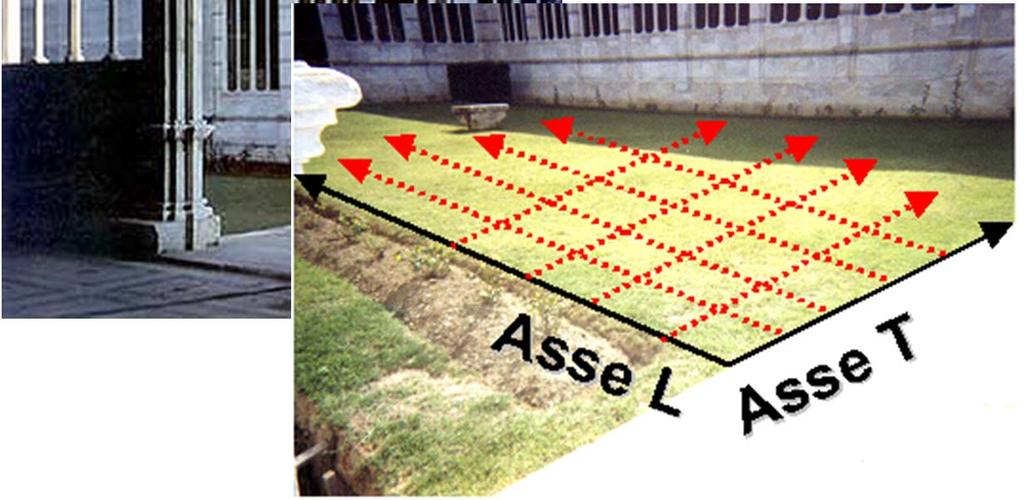
16 Multichannel visualization 3D reconstruction PPG/2008/00xx All rights reserved to IDS 16
17 Visualization in 3D utilises time slicing Slice depth depth cm cm Slice depth depth cm cm Slice depth depth cm cm Slice depth depth cm cm The data related to an area is elaborated with a specific processing (comprising the migration) In visualization, the user can slice the area investigated to different depths
, Radar scans parallel to the acquisition direction, Virtual Radar scans orthogonal to the acquisition direction 3D")
18 DIVISIONE Argomento della presentazione GRED HD 3D : post processing software The GRED HD software comes with a 3D graphic interface. The software is able to show: Tomography (time slices), Radar scans parallel to the acquisition direction, Virtual Radar scans orthogonal to the acquisition direction 3D view. Logo di prodotto November 2008


19 DIVISIONE Argomento della presentazione Logo di prodotto PPG/2008/00xx All rights reserved to IDS 19
20 Two Electrical Properties Of Importance To GPR Work Electrical conductivity (inverse of resistivity) σ is a measure of a material s ability to carry an electric current The value is primarily controlled by water content and/or clay content Higher conductivity makes radar signal penetration difficult Relative dielectric permittivity (Dielectric constant) Measures the capacity of a material to store charge when an electric field is applied The value ranges from 1 to 81 (1 = air, 81 = water); the value (for soils) is mainly controlled by water content Differences in dielectric properties between two adjacent materials through which the radar wave propagates will cause reflection of some of the radar energy back to the surface The strength of reflections is controlled by the contrast in the dielectric constants of the two adjacent materials. PPG/2008/00xx All rights reserved to IDS 20
21 Depth of investigation Decreases as: Electrical Conductivity Increases Water Content Increases Clay Content Increases Scattering Increases Conductive Contaminant Increases GPR user has no control over the above factors--these are site specific characteristics. Increases as: Antenna Frequency Decreases Transmitter Power Increases Receiver Sensitivity Increases GPR user has control over the above factors to some degree 21
22 Features of GPR antennas Center Sample Depth Typical Frequency (MHz) Applications (m) Range (ns) 80 Geologic MLF Geologic Geologic, Environmental Shallow Geology, Engineering, Environmental Shallow Geology, Engineering, Environmental, Archaeology 900 Concrete, Soils, Archaeology 22
23 Selection of better antennas DEPTH RANGE OF INTEREST PRIMARY ANTENNA SECOND CHOICES m (0-1.5 ft) 1000 MHz 900 MHz 0-1 m (0-3 ft) 900 MHz 500 MHz m (0-8 ft) 500 MHz 300 MHz 0-9 m (0-30 ft) 300 MHz 120, 100 MHz 0-20 m (0-60 ft) MLF (80, 40, 32, 20, 16 MHz) 0 - >20 m (0 - >60ft) MLF (80, 40, 32, 20, 16 MHz) 100 MHz 100 MHz 23
24 The grid of acquisition scans L axis 6 4 T Scans Orthogon al cartesian reference system 2 L Scans T axis 24
25 DIVISIONE Argomento della presentazione Logo di prodotto SINGLE ANTENNA 40cm 40cm 2m 40cm Uncomplete covering Low probability of detection Difficult compromise Complete covering Increasing of acquisition time 25
 80 70 60 50 40 1 antenna 2 antenne 3 antenne 4 antenne")
26 DIVISIONE Argomento della presentazione Logo di prodotto Increasing of performance using an array PFA= 10-1 Covering with array PD(%) antenna 2 antenne 3 antenne 4 antenne 26
27 Sub Surface Investigation PPG/2008/00xx All rights reserved to IDS 27

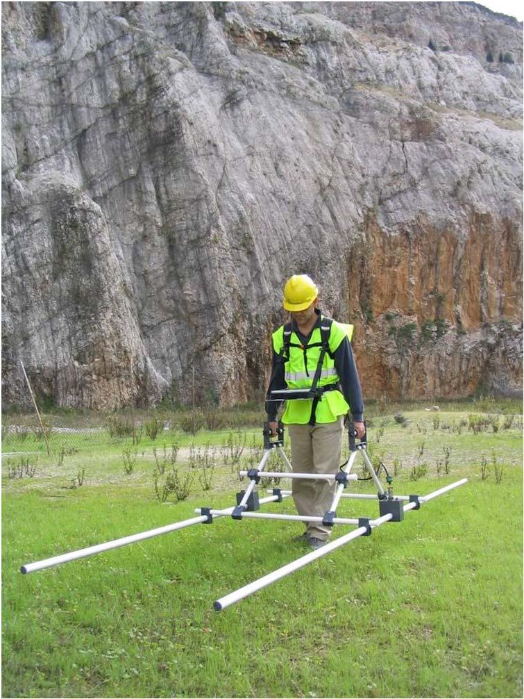
28 Configuration for Archeology research: RIS MF Hi-Mod RIS MF Hi-Mod is a specialized system able to investigate big areas with a 3 D view of the subsoil with a high capability of resolution and penetration depth. Thanks to the high capability of the radar and to the experience of the archaeologists is possible to know with very high level of confidence the buried underground objects and to plan the excavation activities. 4 dual frequency antennas (200 MHz and 600 MHz) 2 m wide Antenna Array for 3D mapping Modular design suited to urban environment and narrow passages High productivity post-processing SW CAD/GIS automatic rendering Data Base for rational storage of large quantities of data

29 MODULAR COMPOSITION and UPGRADABILITY CONFIGURATION MODEL ANTENNAS PICTURE UPGRADABILITY BASIC RIS MF Hi-Mod #1 1 INTERMEDIATE RIS MF Hi-Mod #2 2 or RIS MF Hi-Mod #3 3 FULL RIS MF Hi-Mod #4 4


30 DAD Fast Wawe Aluminium steering handle 2 Batteries Reconfigurable array structure All terrains High maneuverability Robust and light High penetration depth Easily mounted and reconfigurable Chain connection plug and play Fast Wave DAD: high stacking factor 4 dual-frequency antennas ( MHz)


31 IDS GPR available antennas 100 MHz antenna 2000 MHz antenna 25/40 MHz antenna


32 Other Shielded Antennae Options November PPG/2008/00xx All rights reserved to IDS 32
33 Post Processing Software: end results

34 DIVISIONE Argomento della presentazione Logo di prodotto GPR site testing in Rovereto with Hi-MOD system July 2009 All rights reserved to IDS


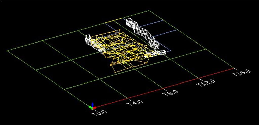
35 DIVISIONE Testing Rovereto Field Argomento della presentazione Logo di prodotto The test area is a 1500 square meters wide trapezium. Many T and L scans were made to detect well known buried structures. July 2009 All rights reserved to IDS

36 DIVISIONE Argomento della presentazione GPR Tomography Results Depth: 0,7m. Looking at the tomography we easily detect some of the hidden targets (red circles). The green line represents an unsignaled pipe while the green box shows a couple of strong reflections of unknown origin. The final step of the survey is mapping our discoveries using a CAD interface. July 2009 All rights reserved to IDS Logo di prodotto


37 DIVISIONE Argomento della presentazione Logo di prodotto GPR Tomography Results The final step of the survey is mapping our discoveries using a CAD interface. July 2009 All rights reserved to IDS


38 DIVISIONE Argomento della presentazione GPR Tomography Results Bonus Feature Depth: 0,3 m. An X-shaped pattern. It can be interpreted as some sort of biological track. July 2009 All rights reserved to IDS Logo di prodotto


39 GPR archeological research in Israel: Hark Karkom STRATIGRAPHIC CONTACT CAVITIES 100 MHz antenna


40 GPR archeological research in Italy: San Sebastiano church in Milan Cripta Centrale TOMOGRAPHIC MAP HYSTORICAL MAP


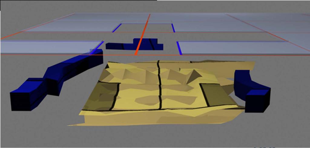
41 GeoRadar Division GPR archeological research in Italy (1/2): square of Miracles - Pisa
: square of")

42 GPR archeological research in Italy (2/2): square of Miracles - Pisa Tomographic map An image of the hold excavation (1936).
43 Structure Investigation PPG/2008/00xx All rights reserved to IDS 43 PPG/2008/00xx All rights reserved to IDS 43
44 DIVISIONE Argomento della presentazione Logo di prodotto GeoRadar Division GPR High Frequency Investigation for Structural Application


45 Used Configuration: Aladdin System Description ALADDIN an advanced radar based sensor for Non-Destructive structural analysis Civil engineering & Cultural heritage applications 3D imaging of shallow and deep rebars in concrete; Inspection of concrete for location of voids; Inspection of concrete thickness, integrity; 3D imaging of pre-tension and post-tension cables; Inspection and analysis of old structures and monuments; Inspection of walls and floors for the location of pipes, objects, caches, etc.. June 2008
")
 permit joint orthogonally polarized scans to")


 in just one scan.")
46 Standard Products ALADDIN Depth: 0.10m Depth: 0.10m The SPECIAL FULL-POLAR highfrequency (2 GHz) antenna combined with the patented Pad Survey Guide (PSG) permit joint orthogonally polarized scans to be acquired in a single pass, detecting shallow and deep structures and halving acquisition time compared to standard methods. Depth: 0.40m Depth: 0.40m Longitudinal dipole Scan direction The standard antenna can read the shallow targets (rebars), but is not able to reveal the lower structures Instead, the FULL-POLAR antenna is able to identify both targets (shallow and deep) in just one scan. Transversal dipole June 2008

47 Direct results in the field by exporting data from K2 acquisition software to Aladdin SW PPG/2008/00xx All rights reserved to IDS 47
 Sao Paulo")
48 DIVISIONE Argomento della presentazione Logo di prodotto GPR High Frequency investigation for structural application (1/4): GPR investigation on the structures of the Sao Paulo (Brasil) Metro line to evaluate: The presence and the spacing of the rebars into a pillar The presence and the spacing of the rebars and/or tendons Used Configuration: Aladdin System (2 GHz Bipolar antenna) Sao Paulo (Brasil) June 2008

 Metro Line - Acquisition")
49 DIVISIONE Argomento della presentazione Logo di prodotto GPR High Frequency investigation for structural application (2/4): Structural Application on the Sao Paulo (Brasil) Metro Line - Acquisition phase June 2008
: Presence and")
 Horizontal spacing between each rebar:")
50 DIVISIONE Argomento della presentazione Logo di prodotto GPR High Frequency investigation for structural application (3/4): Presence and spacing of the rebars 8 iron bars on horizontal side (depth 3cm 6 iron bars on vertical side (depth 5cm) Horizontal spacing between each rebar: 20-25cm June 2008
 20 iron bars in horizontal direction around the pillar (depth 3cm) Double line of rebars.")
51 DIVISIONE Argomento della presentazione Logo di prodotto GPR High Frequency investigation for structural application (4/4): Presence and spacing of the rebars into the pillar 15 iron bars in vertical direction (depth 5 cm) 20 iron bars in horizontal direction around the pillar (depth 3cm) Double line of rebars. Horizontal spacing between each rebar: 10-20cm June 2008

52 DIVISIONE Argomento della presentazione Logo di prodotto GPR High Frequency investigation for structural application (1/3): GPR investigation, on the test site of the Roma Metro line to evaluate: The presence of the cavity behind the concrete layer Used Configuration: 900MHz and 2GHz antenna Rome, Italy June 2008

: The")

53 DIVISIONE Argomento della presentazione Logo di prodotto GPR High Frequency investigation for structural application (2/3): The test site on Rome Metro line - Acquisition phase Concrete layer Artificial cavity June 2008


54 DIVISIONE Argomento della presentazione Logo di prodotto GPR High Frequency investigation for structural application (3/3): Results Iron bars Limit of the concrete layer Gap created by the artificial cavity June 2008

55 GPR research in Italy (1/2): Saint Pieter s square - Rome Aladdin San Bonaventura statue 14 longitudinal scans and 8 transversal scans 6 longitudinal scans on the base each 10 cm


 Scan 16")
56 GPR research in Italy (2/2): Saint Pieter s square - Rome San Bonaventura statue Different layers and cavity (red area) Scan 16 natural layers (depth: 25-30cm) Scan 16 - Cavity (depth: 24cm)

57 GeoRadar Division GPR Configuration in Tunneling All rights reserved to IDS 57
")
 Antenna: Single Channel Antenna")
.")


58 RIS Configuration for tunneling COMPONENTS: Data Logger (PC Panasonic CF 19 or other PC) Single or Multi Channel Control Unit (DAD 1CH or DAD MCH) Antenna: Single Channel Antenna (frequency fro 200 MHz up to 2 GHz) or Array of antenna (TR600V-HF, High Frequency array). All IDS Antennas Survey kit. Data Logger: PC Panasonic CF MHz Antenna Data Logger: PC Hammerhead HF54 DAD-MCH Multi Channel Control Unit 1600 MHz Antenna All rights reserved to IDS 58


: 20x26x20 cm")
")

59 ANTENNA FEATURES TR H Antenna TR600V-900 Antenna TR600V-2GHz Array Antenna Type: Shielded Dipole Nominal Frequency: from 200 MHz up to 2 GHz 200, H MHz Antenna Dimensions (LxWxH): 43x37x20 cm 600-V MHz and 900 MHz Antenna Dimensions (LxWxH): 20x26x20 cm HF (2GHz) Antenna Dimensions (LxWxH): 13x12x8 cm Relative humidity: <90% (non-condensing) Rain Proof (IP 65) Temperature: -40 C / 50 C TRHF-2GHz Antenna N 2 TR600V Array All rights reserved to IDS 59
: Study of the fractures, stratigraphy and anomaly in the tunnel to evaluate the structure")
")
60 GPR investigation in a Tunnel along a rail track (1/2) Geotechnical application in the Gorsexio tunnel along the rail line Genova-Ovada (Italy): Study of the fractures, stratigraphy and anomaly in the tunnel to evaluate the structure stability and the presence of area with a risk of water infiltration. Used Configuration: RIS One with 200MHz and 600 MHz Antennas Gorsexio tunnel along the rail line Genova-Ovada ( Italy) Gorsexio Tunnel Acquisition phase All rights reserved to IDS 60
 Internal transition 2 different")


61 GPR investigation in a Tunnel along a rail track (2/2) Internal transition 2 different layers of bricks Contact between tunnel structure and bedrock 600 MHz Results Fracture Fracture Fractured area with water Gorsexio Tunnel Acquisition phase 200 MHz Results All rights reserved to IDS 61

62 IBIS FS Interferometry system for displacement monitoring of historical structures Remote static and dynamic monitoring of structures. IBIS-FS is able to remotely monitor for static applications such as structural load testing, structural displacement and collapse hazards as well as cultural heritage preservation without needing direct access to the site or the use of any invasive equipment. It is also able to perform dynamic monitoring applications including structural resonance frequency measurements, structural modal shape analysis and real time deformation monitoring. PPG/2008/00xx All rights reserved to IDS 62

63 Remote sensing: Real-time remote sensing at up to 1 km with from the monitored structure. Accurate measurements: Measures displacements of as little as 0.01mm and up to 0,5 Km. No standard instrument can achieve such accuracy. Sampling: Structural vibration sampling up to 200 Hz. PPG/2008/00xx All rights reserved to IDS 63
 and the deformation velocity of the monitored")
64 The system can be measure 10mm displacement in 0.005s Or the system can measure 100mm in 200Hz Or higher, depending on the monitoring time (1 minutes or several minutes) and the deformation velocity of the monitored structure PPG/2008/00xx All rights reserved to IDS 64
GPR SURVEY METHOD. Ground probing radar
 The ground penetrating radar (GPR - Ground Probing Radar) is a geophysical method used to investigate the near surface underground. Thanks to its high degree of resolution, the GPR is the most effective
Opera Duo. GeoRadar Division
 Utilities Detection and Mapping Opera Duo: real-time detection of pipes RIS MF Hi-Mod: Utilities mapping on all zones All rights reserved to IDS 2 Utilities Detection and Mapping Stream: massive arrays
GROUND PENETRATING RADAR (GEORADAR) INSPECTION
 INSPECTION") - CIVIL ENGENEERING - GEOLOGY AND ENVIRONMENT - GROUND PENETRATING RADAR - LOSSES DETECTING RADAR SYSTEM - ARCHEOLOGY & CULTURAL HERITAGE - CARGO INSPECTION - LOSS CONTROL - CHEMICAL ANALYSIS - INDUSTRIAL
- CIVIL ENGENEERING - GEOLOGY AND ENVIRONMENT - GROUND PENETRATING RADAR - LOSSES DETECTING RADAR SYSTEM - ARCHEOLOGY & CULTURAL HERITAGE - CARGO INSPECTION - LOSS CONTROL - CHEMICAL ANALYSIS - INDUSTRIAL
Strategic City Wide Mapping of Underground Assets using Ground Penetrating Radar. Mark Bell
 Strategic City Wide Mapping of Underground Assets using Ground Penetrating Radar Mark Bell XXV International Federation of Surveyors Congress, Kuala Lumpur, Malaysia, 16 21 June 2014 TOPICS GPR background
The use of high frequency transducers, MHz, allowing the resolution to target a few cm thick in the first half meter suspect.
 METHODOLOGY GPR (GROUND PROBING RADAR). In recent years the methodology GPR (Ground Probing Radar) has been applied with increasing success under the NDT thanks to the high speed and resolving power. As
GeoRadar Division A HISTORY OF PROVIDING HIGH TECHNOLOGY. IDS s Pisa Headquarters
 A HISTORY OF PROVIDING HIGH TECHNOLOGY IDS s Pisa Headquarters Subsidiary and office across four continents IDS Tech (Ottawa) IDS North America (Montréal) IDS UK (Fareham) Sistemi Dinamici A joint venture
L O C A T O R G P R. Introducing the. Radarteam. Ground Probing Radar/Antenna system with Rugged PC and Cart ü
 Introducing the L O C A T O R G P R Ground Probing Radar/Antenna system with Rugged PC and Cart ü Fully integrated system. Multi Frequency operation: 100-900 MHz ü Air/Ground Coupled operation. Multiple
Advanced Utility Locating Technologies (R01B)
") Advanced Utility Locating Technologies (R01B) Jacob Sheehan Senior Geophysicist Olson Engineering Phil Sirles Principal Geophysicist Olson Engineering Introduction: Utility Bundle Overview SHRP2 Strategic
Advanced Utility Locating Technologies (R01B) Jacob Sheehan Senior Geophysicist Olson Engineering Phil Sirles Principal Geophysicist Olson Engineering Introduction: Utility Bundle Overview SHRP2 Strategic
COBRA CBD UNPARALLELED QUALITY GPR DATA WITHOUT BLIND SPOTS
 COBRA CBD WIRELESS GPR Introducing the smart CBD ANTENNA Triple frequency 200/400/800 MHz Outstanding 50-1400 MHz bandwidth Replaces several conventional antennas UNPARALLELED QUALITY GPR DATA WITHOUT
THE BEST GPR DATA QUALITY AT THE BEST PRICE! GROUND PENETRATING RADAR ZOND-12e G R O U N D P E N E T R A T I N G R A D A R S
 GROUND PENETRATING RADAR ZOND-12e General Purpose Pulse GPR ZOND-12e SINGLE CHANNEL OR ADVANCED CONTROL UNITS ZOND 12e GPR is a portable digital Ground Penetrating Radar carried by a single operator. The
Opera Duo. Opera Duo. GeoRadar Division. a first class underground survey
 a first class underground survey Opera Duo Competitive advantages Designed around you A large, comfortable handle to make pushing an pulling easier, large wheels for better control and a balanced weight
GPR Data Acquisition and Interpretation
 1 GPR Data Acquisition and Interpretation Mezgeen Rasol PhD Candidate Geophysics and Seismic Engineering Polytechnic University of Catalonia mezgeen.rasol@upc.edu BIG-SKY-EARTH Cost Action TD143 Workshop
SIMULATION OF GPR SCENARIOS USING FDTD
 SIMULATION OF GPR SCENARIOS USING FDTD 1 GAMIL ALSHARAHI, 2 ABDELLAH DRIOUACH, 3 AHMED FAIZE 1,2 Department of physic, Abdelmalek Essaâdi University, Faculty of sciences, Morocco 3 Department of physic,
Ground Penetrating Radar
 Ground Penetrating Radar Begin a new section: Electromagnetics First EM survey: GPR (Ground Penetrating Radar) Physical Property: Dielectric constant Electrical Permittivity EOSC 350 06 Slide Di-electric
Advanced Ground Investigation Techniques to Help Limit Risk or Examine Failure. Advanced Subsurface Investigations
 Advanced Ground Investigation Techniques to Help Limit Risk or Examine Failure Overview Introduction What is geophysics? Why use it? Common Methods Seismic Ground Radar Electrical Case Studies Conclusion
Use of ground based radar to monitor the effect of increased axle loading on rail bridges. Evgeny Shilov. IDS GeoRadar
 Use of ground based radar to monitor the effect of increased axle loading on rail bridges aa Evgeny Shilov IDS GeoRadar Background of Techniques All rights reserved to IDS GeoRadar 2 Radar technology Radar
Using georadar systems for mapping underground utility networks
 Available online at www.sciencedirect.com ScienceDirect Procedia Engineering 209 (2017) 216 223 Urban Subsurface Planning and Management Week, SUB-URBAN 2017, 13-16 March 2017, Bucharest, Romania Using
Ground Penetrating Radar (GPR) By Dr. Eng. Zubair Ahmed
 By Dr. Eng. Zubair Ahmed") Ground Penetrating Radar (GPR) By Dr. Eng. Zubair Ahmed Acknowledgement Golder Associates, Whitby, Ontario Stantec Consulting, Kitchener, Ontario Infrasense Inc. USA Geophysical Survey Systems Inc. (GSSI),
Ground Penetrating Radar (GPR) By Dr. Eng. Zubair Ahmed Acknowledgement Golder Associates, Whitby, Ontario Stantec Consulting, Kitchener, Ontario Infrasense Inc. USA Geophysical Survey Systems Inc. (GSSI),
Ground Penetrating Radar (day 1) EOSC Slide 1
 EOSC Slide 1") Ground Penetrating Radar (day 1) Slide 1 Introduction to GPR Today s Topics Setup: Motivational Problems Physical Properties - Dielectric Permittivity and Radiowaves - Microwave Example Basic Principles:
Ground Penetrating Radar (day 1) Slide 1 Introduction to GPR Today s Topics Setup: Motivational Problems Physical Properties - Dielectric Permittivity and Radiowaves - Microwave Example Basic Principles:
Report. Mearns Consulting LLC. Former Gas Station 237 E. Las Tunas Drive San Gabriel, California Project # E
 Mearns Consulting LLC Report Former Gas Station 237 E. Las Tunas Drive San Gabriel, California Project #1705261E Charles Carter California Professional Geophysicist 20434 Corisco Street Chatsworth, CA
Pitfalls in GPR Data Interpretation: Differentiating Stratigraphy and Buried Objects from Periodic Antenna and Target Effects
 GEOPHYSICAL RESEARCH LETTERS, VOL. 27, NO. 20, PAGES 3393-3396, OCTOBER 15, 2000 Pitfalls in GPR Data Interpretation: Differentiating Stratigraphy and Buried Objects from Periodic Antenna and Target Effects
7. Consider the following common offset gather collected with GPR.
 Questions: GPR 1. Which of the following statements is incorrect when considering skin depth in GPR a. Skin depth is the distance at which the signal amplitude has decreased by a factor of 1/e b. Skin
3D UTILITY MAPPING USING ELECTRONICALLY SCANNED ANTENNA ARRAY. Egil S. Eide and Jens F. Hjelmstad
 D UTILITY MAPPING USING ELECTRONICALLY SCANNED ANTENNA ARRAY Egil S. Eide and Jens F. Hjelmstad Department of Telecommunications Norwegian University of Science and Technology, N-79 Trondheim, Norway eide@tele.ntnu.no
RECONSTRUCTION OF BURIED OBJECTS BY IMPLEMENTATION OF GROUND PENETRATING RADAR TECHNIQUE: EXAMPLE ON ROMAN TOMB IN BRESTOVIK (SERBIA)
") Geoarchaeology and Archaeomineralogy (Eds. R. I. Kostov, B. Gaydarska, M. Gurova). 2008. Proceedings of the International Conference, 29-30 October 2008 Sofia, Publishing House St. Ivan Rilski, Sofia,
Geoarchaeology and Archaeomineralogy (Eds. R. I. Kostov, B. Gaydarska, M. Gurova). 2008. Proceedings of the International Conference, 29-30 October 2008 Sofia, Publishing House St. Ivan Rilski, Sofia,
Exploration Beyond Expectation. Geo-Carte Radar Technology Pvt. Ltd.
 Exploration Beyond Expectation Geo-Carte Radar Technology Pvt. Ltd. Problem Unknown distribution network of underground pipeline in India 32% Damage of pre-existing underground utilities during laying
CASE STUDY BRIDGE DYNAMIC MONITORING
 Introduction BRIDGE DYNAMIC MONITORING Monitoring of structure movements and vibrations (bridges, buildings, monuments, towers etc.) is an increasingly important task for today s construction engineers.
Archaeo-Geophysical Associates, LLC
 Geophysical Survey at the Parker Cemetery Rockwall, Texas. AGA Report 2010-6 Report Submitted To: Texas Cemetery Restoration 10122 Cherry Tree Dr. Dallas, Texas 75243 May 14, 2010 Chester P. Walker, Ph.D.
Advances in NDE Technology WHATS NEW?
 Advances in NDE Technology WHATS NEW? Glen Simula, Owner GS Infrastructure, Inc. The state of America s deteriorating infrastructure presses us to find solutions to assess, with limited funds and resources.
Electromagnetic Induction
 Electromagnetic Induction Recap the motivation for using geophysics We have problems to solve Slide 1 Finding resources Hydrocarbons Minerals Ground Water Geothermal Energy SEG Distinguished Lecture slide
Tri-band ground penetrating radar for subsurface structural condition assessments and utility mapping
 Tri-band ground penetrating radar for subsurface structural condition assessments and utility mapping D. Huston *1, T. Xia 1, Y. Zhang 1, T. Fan 1, J. Razinger 1, D. Burns 1 1 University of Vermont, Burlington,
Results of GPR survey of AGH University of Science and Technology test site (Cracow neighborhood).
.") Results of GPR survey of AGH University of Science and Technology test site (Cracow neighborhood). October 02, 2017 Two GPR sets were used for the survey. First GPR set: low-frequency GPR Loza-N [1]. Technical
Results of GPR survey of AGH University of Science and Technology test site (Cracow neighborhood). October 02, 2017 Two GPR sets were used for the survey. First GPR set: low-frequency GPR Loza-N [1]. Technical
VALIDATION OF GROUND PENETRATING RADAR DATA INTERPRETATION USING AN ELECTROMAGNETIC WAVE PROPAGATION SIMULATOR
 Romanian Reports in Physics, Vol. 68, No. 4, P. 1584 1588, 2016 VALIDATION OF GROUND PENETRATING RADAR DATA INTERPRETATION USING AN ELECTROMAGNETIC WAVE PROPAGATION SIMULATOR A. CHELMUS National Institute
Assessment of layer thickness and uniformity in railway embankments with Ground Penetrating Radar
 Assessment of layer thickness and uniformity in railway embankments with Ground Penetrating Radar F.M. Fernandes Department of Civil Engineering, University of Minho, Guimarães, Portugal M. Pereira Geotechnique
GPR Part II: Effects of conductivity. Surveying geometries. Noise in GPR data. Summary notes with essential equations. Some Case histories
 GPR Part II: Effects of conductivity Surveying geometries Noise in GPR data Summary notes with essential equations Some Case histories EOSC 350 06 Slide 1 GPR Ground Penetrating Radar R = ε ε 2 2 + ε ε
Resolution in evaluation of structural elements by using ground-penetrating radar.
 Resolution in evaluation of structural elements by using ground-penetrating radar. V. Perez-Gracia Departamento de Resistencia de Materiales y Estructuras en la Ingeniería. EUETIB/CEIB. Universidad Politécnica
GeoRadar Division. Geosystems BU A HISTORY OF PROVIDING HIGH TECHNOLOGY. IDS s Pisa Headquarters
 A HISTORY OF PROVIDING HIGH TECHNOLOGY IDS s Pisa Headquarters Geology and Environment IBIS-FL and IBIS-FMT, a dedicated configuration to enter into monitoring of landslides and mining market IBIS-FL:
Applied Geophysics Nov 2 and 4
 Applied Geophysics Nov 2 and 4 Effects of conductivity Surveying geometries Noise in GPR data Summary notes with essential equations Some Case histories EOSC 350 06 Slide 1 GPR Ground Penetrating Radar
IBIS range. GeoRadar Division. GeoRadar Division. Static and Dynamic Monitoring of Civil Engineering Structures by Microwave Interferometry
 Static and Dynamic Monitoring of Civil Engineering Structures by Microwave Interferometry Garry Spencer and Mark Bell 1 PRODUCTS IBIS range APPLICATIONS IBIS - FL LANDSLIDE & DAM MONITORING IBIS - FM SLOPE
CHC MINING DEFORMATION MONITORING SOLUTION
 CHC MINING DEFORMATION MONITORING SOLUTION Safety is first in mining. CHC offers solutions designed to improve safety for personnel on the ground and in the cab with 24/7 precision positioning for automatic
Dynamic control of historical buildings through interferometric radar technique.
 . An useful approach for Structural Health Monitoring on earthquake damaged structures. Sergio Vincenzo Calcina, Luca Piroddi and Gaetano Ranieri Università di Cagliari Dipartimento di Ingegneria Civile,
Ground Penetrating Radar
 REPORT 4A Ground Penetrating Radar Introduction to GPR, and positioning of GPR data Part of R&D project Infrastructure in 3D in cooperation between Innovation Norway, Trafikverket and TerraTec Yta för
P Forsmark site investigation. RAMAC and BIPS logging in borehole HFM11 and HFM12
 P-04-39 Forsmark site investigation RAMAC and BIPS logging in borehole HFM11 and HFM12 Jaana Gustafsson, Christer Gustafsson Malå Geoscience AB/RAYCON March 2004 Svensk Kärnbränslehantering AB Swedish
Experiment on Artificial Frozen Soil Boundary GPR Detection During Cross-passage Construction in Tunnels
 354 Progress In Electromagnetics Research Symposium 2005, Hangzhou, China, August 22-26 Experiment on Artificial Frozen Soil Boundary GPR Detection During Cross-passage Construction in Tunnels Yong-Hui
1. Report No. FHWA/TX-05/ Title and Subtitle PILOT IMPLEMENTATION OF CONCRETE PAVEMENT THICKNESS GPR
 1. Report No. FHWA/TX-05/5-4414-01-3 4. Title and Subtitle PILOT IMPLEMENTATION OF CONCRETE PAVEMENT THICKNESS GPR Technical Report Documentation Page 2. Government Accession No. 3. Recipient s Catalog
User Guide. Life detection with. RescueRadar
 User Guide Life detection with RescueRadar 2 Table of contents Table of contents 1. Locate life Save lives... 4 1.1 The function, the most important briefly... 4 1.2 Range of applications... 5 2. Scope
GPR Investigation: Post Tension Cable Mapping
 CMD Civil Pty Ltd PO Box 1119 Huntingdale VIC 3166 +61 3 9544 8833 info@cmdcivil.com www.cmdcivil.com Case Study: GPR Investigation: Post Tension Cable Mapping This application note demonstrates an example
RADAR INSPECTION OF CONCRETE, BRICK AND MASONRY STRUCTURES
 RADAR INSPECTION OF CONCRETE, BRICK AND MASONRY STRUCTURES C.P.Hobbs AEA Industrial Technology Materials and Manufacturing Division Nondestructive Testing Department Building 447 Harwell Laboratory Oxon
SURVEYING THE UNDERGROUND
 SURVEYING THE UNDERGROUND An Introduction to ASCE 38-02 and the Practice of Subsurface Utility Engineering ACECMD March 28, 2018 Presented by: Art Worthman A. Morton Thomas & Associates, Inc. John Berrettini
GPR based Detection of Structurally Weak Zones of Road Pavement
 2012 International Conference on Traffic and Transportation Engineering (ICTTE 2012) IPCSIT vol. 26 (2012) (2012) IACSIT Press, Singapore GPR based Detection of Structurally Weak Zones of Road Pavement
a step change in Ground Penetrating Radar technology Guido Manacorda Engineering Manager
 The ORFEUS Project: a step change in Ground Penetrating Radar technology to locate buried utilities Guido Manacorda Engineering Manager IDS Ingegneria dei Sistemi i SpA Key issues Many ypp pipes and cables
Applications _. Features and benefits _. Technical assitance. Inclinometer probe servo accelerometer > LEA_EN_INC
 LEA_EN_INC1001001 Inclinometer Probe Servo Accelerometer LEA_EN_INC1001001 Inclinometer Probe Servo Accelerometer Descrizione _ The inclinometer probe is used in geotechnical and structural monitoring
ESTIMATION OF REBAR DIAMETER IN CONCRETE STRUCTURAL ELEMENTS USING GROUND PENETRATING RADAR
 More info about this article: http://www.ndt.net/?id=21143 ESTIMATION OF REBAR DIAMETER IN CONCRETE STRUCTURAL ELEMENTS USING GROUND PENETRATING RADAR Bhaskar Sangoju and Ramanjaneyulu, K. Scientists,
Non Invasive Electromagnetic Quality Control System
 ECNDT 2006 - Tu.4.6.2 Non Invasive Electromagnetic Quality Control System Jérôme DREAN, Luc DUCHESNE, SATIMO, Courtaboeuf, France Per NOREN, SATIMO, Gothenburg (Sweden) Abstract. The quality control of
A Report on the Ground Penetrating Radar Survey 205 Little Plains Road Southampton, NY
 A Report on the Ground Penetrating Radar Survey 205 Little Plains Road Southampton, NY November 18, 2016 Conducted by Robert W. Perry TOPOGRAPHIX, LLC Hudson, NH Requested by Southampton Town Historical
Ground Penetrating Radar: Impulse and Stepped Frequency
 Ground Penetrating Radar: Impulse and Stepped Frequency Carey M. Rappaport Professor Elect. and Comp. Engineering Northeastern University CenSSIS Workshop SW3, November 15, 2 Center for Subsurface Sensing
Surface Deployed / Ground Sensors
 Surface Deployed / Ground Sensors WS2 Vibro-acoustics WS3 - Non-Contact Electrical Resistivity techniques WS3 Electromagnetic methods WS4 Detecting changes in the ground Key Achievements and Findings Surface
Using ground penetrating radar to quantify changes in the fracture pattern associated with a simulated rockburst experiment
 Using ground penetrating radar to quantify changes in the fracture pattern associated with a simulated rockburst experiment by M. Grodner* Synopsis Ground Penetrating Radar (GPR) is an electromagnetic
Fundamental Study on NDT of Building Wall Structure by Radar
 7th European Workshop on Structural Health Monitoring July 8-11, 2014. La Cité, Nantes, France More Info at Open Access Database www.ndt.net/?id=17135 Fundamental Study on NDT of Building Wall Structure
ALIS. Project Identification Project name Acronym
 ALIS Project Identification Project name ALIS Acronym Advanced Landmine Imaging System Participation Level National (Japanese) Financed by JST(Japan Science and Technology Agency) Budget N/A Project Type
Microtremor Array Measurements and Three-component Microtremor Measurements in San Francisco Bay Area
 Microtremor Array Measurements and Three-component Microtremor Measurements in San Francisco Bay Area K. Hayashi & D. Underwood Geometrics, Inc., United States SUMMARY: Microtremor array measurements and
HGD HURRICANE 2010 / 2011
 HGD HURRICANE 2010 / 2011 The Global Surprise For the Treasures Hunters, Prospecting Amateurs, for all Researchers for Gold and Underground Metals Introduction: The Modern scientific Innovation, Exclusive
In search of a Historic Grave: GPR Investigation near the Yellowstone Lake Store: 7/15/2010
 In search of a Historic Grave: GPR Investigation near the Yellowstone Lake Store: 7/15/2010 Steven Sheriff Professor of Geophysics Department of Geosciences University of Montana Missoula, Montana Introduction
EISCAT Scientific Association Technical Specification and Requirements for Antenna Unit V 2.0
 EISCAT Scientific Association Technical Specification and s for Antenna Unit V 2.0 1. Technical Specification for Antenna Unit The EISCAT Scientific Association, also called "EISCAT" throughout this document,
ARCHAEOLOGICAL GEOPHYSICS: SENSOR SELECTION AND SITE SUITABILITY
 ARCHAEOLOGICAL GEOPHYSICS: SENSOR SELECTION AND SITE SUITABILITY A SPARC Webinar presented on October 17, 2014 Eileen G. Ernenwein, PhD ETSU: http://faculty.etsu.edu/ernenwei/ CAST: http://goo.gl/wyzlp
GPR SYSTEM USER GUIDE AND TROUBLESHOOTING GUIDE
 GPR SYSTEM USER GUIDE AND TROUBLESHOOTING GUIDE Implementation Report 5-4414-01-1 Project Number 5-4414-01 Subsurface Sensing Lab Electrical and Computer Engineering University of Houston 4800 Calhoun
Chapter 4 Results. 4.1 Pattern recognition algorithm performance
 94 Chapter 4 Results 4.1 Pattern recognition algorithm performance The results of analyzing PERES data using the pattern recognition algorithm described in Chapter 3 are presented here in Chapter 4 to
GPR ANTENNA ARRAY FOR THE INSPECTION OF RAILWAY BALLAST
 Proceedings of the National Seminar & Exhibition on Non-Destructive Evaluation NDE 2011, December 8-10, 2011 GPR ANTENNA ARRAY FOR THE INSPECTION OF RAILWAY BALLAST Th. Kind BAM Federal Institute for Materials
Noggin Competitive Analysis. Copyright 2016, Sensors & Software Copyright 2015, Sensors & Software
 Noggin Competitive Analysis Copyright 2015, Sensors & Software Competitive Analysis why do it? Understand the market place & build our product knowledge Learn how we compare Help identify our unique selling
Using GPR Technique Assessment for Study the Sub-Grade of Asphalt and Concrete Conditions
 Using GPR Technique Assessment for Study the Sub-Grade of Asphalt and Concrete Conditions Alaa S. Mahdi Remote Sensing Unit, College of Science, University of Baghdad, Baghdad, Iraq Abstract The Ground
Effect of Antennae Polarization Relative to Tunnel Orientation on Electromagnetic Wave Scattering due to Underground Tunnels
 Presented at the COMSOL Conference 2009 Boston Effect of Antennae Polarization Relative to Tunnel Orientation on Electromagnetic Wave Scattering due to Underground Tunnels Arvin Farid Assistant Professor
ANALYSIS OF RADIO WAVE PROPAGATION IN SOIL WITH APPLICATION IN ARCHEOLOGY
 ANALYSIS OF RADIO WAVE PROPAGATION IN SOIL WITH APPLICATION IN ARCHEOLOGY A. CHELMUS, D. ENE, L. ANGHELUTA National Institute for Research and Development in Optoelectronics-INOE 2000, Atomistilor str.
New Instrumentation technologies
 New Instrumentation technologies Daniel Naterop, Solexperts Ltd. Switzerland Technologies used for other application than for geotechnical instrumentation have been recently used successfully for civil
OPERATIVE GUIDE V.E.S. VERTICAL ELECTRIC SURVEY
 OPERATIVE GUIDE V.E.S. VERTICAL ELECTRIC SURVEY 1 Quadrupole geoelectric procedure (V.E.S.) Generals V.E.S. (Vertical Electric Survey) geoelectric prospection method consists in investigating a specific
DISPLACEMENT AND DEFORMATION MEASUREMENT USING GROUND RADAR INTERFEROMETRY TECHNIQUE
 JOURNAL OF APPLIED ENGINEERING SCIENCES Article Number: 124_VOL. 1(16), issue 1_2013, pp.111-118 ISSN 2247-3769 ISSN-L 2247-3769 (Print) / e-issn:2284-7197 DISPLACEMENT AND DEFORMATION MEASUREMENT USING
Geophysical Survey Rock Hill Bleachery TBA Site Rock Hill, South Carolina EP-W EPA, START 3, Region 4 TABLE OF CONTENTS Section Page Signature
 Geophysical Survey Rock Hill Bleachery TBA Site Rock Hill, South Carolina EP-W-05-054 EPA, START 3, Region 4 Prepared for: Tetra Tech EM, Inc. October 12, 2012 Geophysical Survey Rock Hill Bleachery TBA
Diagnostics of Bridge Pavements by Ground Penetrating Radar
 11th European Conference on Non-Destructive Testing (ECNDT 2014), October 6-10, 2014, Prague, Czech Republic Diagnostics of Bridge Pavements by Ground Penetrating Radar Radek MATULA 1, Josef STRYK 1, Karel
Case Studies and Innovative Uses of GPR for Pavement Engineering Applications
 Case Studies and Innovative Uses of GPR for Pavement Engineering Applications Richard Korczak, MASc., P.Eng., Stantec Consulting Ltd. Amir Abd El Halim, PhD., P.Eng., Stantec Consulting Ltd. Paper prepared
Covert Tunnel Detection Technologies
 2015 Covert Tunnel Detection Technologies Homeland Security Research Corp. Covert Tunnel Detection Technologies 2015 August 2015 Homeland Security Research Corp. (HSRC) is an international market and technology
SODAR- sonic detecting and ranging
 Active Remote Sensing of the PBL Immersed vs. remote sensors Active vs. passive sensors RADAR- radio detection and ranging WSR-88D TDWR wind profiler SODAR- sonic detecting and ranging minisodar RASS RADAR
Understanding Seismic Amplitudes
 Understanding Seismic Amplitudes The changing amplitude values that define the seismic trace are typically explained using the convolutional model. This model states that trace amplitudes have three controlling
Three-dimensional investigation of buried structures with multi-transducer parametric sub-bottom profiler as part of hydrographical applications
 Three-dimensional investigation of buried structures with multi-transducer parametric sub-bottom profiler as part Jens LOWAG, Germany, Dr. Jens WUNDERLICH, Germany, Peter HUEMBS, Germany Key words: parametric,
Geology 228/378 Environmental Geophysics Lecture 10. Electromagnetic Methods (EM) I And frequency EM (FEM)
 I And frequency EM (FEM)") Geology 228/378 Environmental Geophysics Lecture 10 Electromagnetic Methods (EM) I And frequency EM (FEM) Lecture Outline Introduction Principles Systems and Methods Case Histories Introduction Many EM
Geology 228/378 Environmental Geophysics Lecture 10 Electromagnetic Methods (EM) I And frequency EM (FEM) Lecture Outline Introduction Principles Systems and Methods Case Histories Introduction Many EM
Increasing the Probability of Detection and Evaluation of Buried Metallic Objects by Data Fusion GPR- Low Frequency Electromagnetic Sensor Array
 4th European-American Workshop on Reliability of NDE - Poster 4 Increasing the Probability of Detection and Evaluation of Buried Metallic Objects by Data Fusion GPR- Low Frequency Electromagnetic Sensor
ScienceDirect. A comparison of dielectric constants of various asphalts calculated from time intervals and amplitudes
 Available online at www.sciencedirect.com ScienceDirect Procedia Engineering 111 (2015 ) 660 665 XXIV R-S-P seminar, Theoretical Foundation of Civil Engineering (24RSP) (TFoCE 2015) A comparison of dielectric
Radar Methods General Overview
 Environmental and Exploration Geophysics II Radar Methods General Overview tom.h.wilson tom.wilson@mail.wvu.edu Department of Geology and Geography West Virginia University Morgantown, WV Brown (2004)
PS 1000 X-Scan Tips & Tricks. Quick Guide
 PS 1000 X-Scan Tips & Tricks Quick Guide en en QUICK GUIDE Tips & tricks 1. PS 1000 X-Scan Scanning on rough surfaces When the scanner is moved over a rough surface, the distance between the scanner and
Identification of Pipelines from the Secondary Reflect Wave Travel Time of Ground-Penetrating Radar Waves
 Journal of Emerging Trends in Engineering and Applied Sciences (JETEAS) 2 (5): 770-774 Scholarlink Research Institute Journals, 2011 (ISSN: 2141-7016) jeteas.scholarlinkresearch.org Journal of Emerging
Amplitudes Variation of GPR Rebar Reflection Due to the Influence of Concrete Aggregate Scattering
 More Info at Open Access Database www.ndt.net/?id=18402 Amplitudes Variation of GPR Rebar Reflection Due to the Influence of Concrete Aggregate Scattering Thomas KIND Federal Institute for Materials Research
Analysis of Crack Detection in Metallic and Non-metallic Surfaces Using FDTD Method
 ECNDT 26 - We.4.3.2 Analysis of Crack Detection in Metallic and Non-metallic Surfaces Using FDTD Method Faezeh Sh.A.GHASEMI 1,2, M. S. ABRISHAMIAN 1, A. MOVAFEGHI 2 1 K. N. Toosi University of Technology,
Bow Tie Antenna Design for GPR Applications
 INTERNATIONAL JOURNAL OF ELECTRONICS, MECHANICAL AND MECHATRONICS ENGINEERING Vol.6 Num.2-2016 (1187-1194) Doi: 10.17932/IAU.IJEMME.m.21460604.2016.6/2.1187-1194 Saeid KARAMZADEH 1 Oğuz Furkan KILIÇ 2
PRORADAR X1PRO USER MANUAL
 PRORADAR X1PRO USER MANUAL Dear Customer; we would like to thank you for preferring the products of DRS. We strongly recommend you to read this user manual carefully in order to understand how the products
Utility Locating Terminology & Equipment Guide. Utility Survey Corp.
 Utility Locating Terminology & Equipment Guide Utility Survey Corp. Contents Utility Locating Terminology Utility Locating Toning or Scoping Scanning X Ray the Ground & Ground Penetrating Radar 3 4 5 6
THE ROLE OF LOZA RADAR IN EXPLORATION
 www.lozaradar.com THE ROLE OF LOZA RADAR IN EXPLORATION 25 MINUTES NOVEMBER 2016 Georadar development at IZMIRAN and mathematical aspects of subsurface radio probing Introduction LOZA GPR series Applications
An interferometric radar for remote sensing of deflections on large structures
 Structural Studies, Repairs and Maintenance of Heritage Architecture XI 359 An interferometric radar for remote sensing of deflections on large structures C. Gentile, S. Bulgarelli, N. Gallino & A. Oldini
Non Destructive Testing & Modal Analysis for Seismic Risk Assessment
 Non Destructive Testing & Modal Analysis for Seismic Risk Assessment INTERFEROMETRIC RADAR & MODAL ANALYSIS SONIC TEST ARIEL A. DEVAL UNIVERSITY OF TEXAS AT ARLINGTON 1 INTRODUCTION PROJECT OBJECTIVES
Ground Penetrating Radar Theory, Data Collection, Processing, and Interpretation: A Guide for Archaeologists
 Ground Penetrating Radar Theory, Data Collection, Processing, and Interpretation: A Guide for Archaeologists Created by: Lisa Dojack April 2012 Table of Contents Acknowledgments... i Foreword... ii Section
mod. BT 20 / GSM 2004
 Int Via A. Peruch, 64 33077 Sacile (PN) - ITALY Tel. 0434 72459 Fax 0434 72450 www.microset.net info@microset.net mod. BT 20 / GSM 2004 FIELD EXTHENSOR FOR GSM 900MHz BAND INTRODUCTION The BT 20 is a GSM
CONDITIONAL ASSESSMENT OF CIVIL STRUCTURES BY ADVANCED NDT METHODS
 e-issn 2455 1392 Volume 3 Issue 3, March 2017 pp. 127 133 Scientific Journal Impact Factor : 3.468 http://www.ijcter.com CONDITIONAL ASSESSMENT OF CIVIL STRUCTURES BY ADVANCED NDT METHODS Mr.C.Pranesh
Investigation of Bridge Decks Utilizing Ground Penetrating Radar
 Investigation of Bridge Decks Utilizing Ground Penetrating Radar Steve Cardimona *, Brent Willeford *, John Wenzlick +, Neil Anderson * * The University of Missouri-Rolla, Department of Geology and Geophysics
THE CONNECTED INFRASTRUCTURE SOLUTION MONITORING HOW STRUCTURES EVOLVE
 THE CONNECTED INFRASTRUCTURE SOLUTION MONITORING HOW STRUCTURES EVOLVE Loadsensing is a data acquisition and monitoring system which combines state-of-the-art wireless monitoring and advanced software