THE BEST GPR DATA QUALITY AT THE BEST PRICE! GROUND PENETRATING RADAR ZOND-12e G R O U N D P E N E T R A T I N G R A D A R S
|
|
|
- Austin Powell
- 5 years ago
- Views:
Transcription
1 GROUND PENETRATING RADAR ZOND-12e


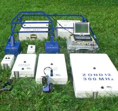
2 General Purpose Pulse GPR ZOND-12e SINGLE CHANNEL OR ADVANCED CONTROL UNITS ZOND 12e GPR is a portable digital Ground Penetrating Radar carried by a single operator. The unit is manufacturing in SINGLE CHANNEL or ADVANCED performance. It is designed for solving a broad range of geotechnical, geological, environmental, engineering and other tasks for nondestructive environmental monitoring. System Advantages Selectable time range from 1 ns to 2000 ns with 1 ns step 320/160/80/40 scans per second in ADVANCED performance 56 scans per second in SINGLE CHANNEL performance 1024/512/256/128 samples per scan in ADVANCED performance with 16 bit resolution 512 samples per scan in SINGLE CHANNEL performance with 16 bit resolution Selectable hardware and software filters Up to 10 points of digital gain function Data transfer through Ethernet or Wi-Fi Data acquisition in original shape Small power consumption


3 MHZ Antenna System DIPOLE, UNSHIELDED, AIR COUPLED Low frequency unshielded air coupled MHZ antenna system with interchangeable dipole set is designed for deeper penetration depth. Antenna s frequency depends on the length of connected dipoles. and CDP data collection modes. Antenna System Advantages Central frequency: 38/75/150 MHz adjustable Weight: 2 kg to 7 kg (depends on frequency) Power: V DC by cable from Transmitter output: 200 V Sounding of sandy hill


4 100 MHZ Antenna System SHIELDED, SURFACE COUPLED Surface coupled 100 MHZ antenna system with separated transmitting and receiving antennas is the lowest frequency shielded antenna. and CDP data collection modes. Antenna System Advantages Central frequency: 100 MHZ Dimensions: 93x65x21 cm each Weight: 13 kg each Power: V DC by cable from Transmitter output: 400 V Detection of a railroad tunnel at 15 m depth, in a limestone rock covered with 2 m of loam

 data collection modes.")

5 300 MHZ Antenna Unit SHIELDED, SURFACE COUPLED Surface coupled 300 MHZ antenna unit is general purpose antenna with coupled transmitting and receiving antennas in strong housing designed for middle penetration depth. and CDP (in combination with another antenna) data collection modes. Antenna Unit Advantages Central frequency: 300 MHZ Dimensions: 102x53x12 cm Weight: 11 kg Power: V DC by cable from Transmitter output: 400 V Sounding of sandy hill

 data collection modes.")

6 500 MHZ Antenna Unit SHIELDED, SURFACE COUPLED Surface coupled 500 MHZ antenna unit is general purpose antenna with coupled transmitting and receiving antennas in strong housing designed for shallow pentration depth and utility detection. and CDP (in combination with another antenna) data collection modes. Antenna Unit Advantages Central frequency: 500 MHZ Dimensions: 72x33x12 cm Weight: 6 kg Power: V DC by cable from Transmitter output: 400 V Fresh water lake profiling from the bottom of the plastic boat

 data collection modes.")

7 750 MHZ Antenna System SHIELDED, AIR COUPLED Air coupled 750 MHZ antenna system with separated transmitting and receiving antennas designed for railroad embankment inspection. and CDP (in combination with another antenna) data collection modes. Antenna System Advantages Central frequency: 750 MHZ Dimensions: 35x20x15 cm each Weight: 2 kg each Power: V DC by cable from Transmitter output: 200 V Railways embankment profiling

 data collection modes.")

8 900 MHZ Antenna Unit SHIELDED, SURFACE COUPLED Surface coupled 900 MHZ antenna unit is general purpose antenna with coupled transmitting and receiving antennas in strong housing designed for shallow pentration depth and utility detection. and CDP (in combination with another antenna) data collection modes. Antenna Unit Advantages Central frequency: 900 MHZ Dimensions: 52x24x12 cm Weight: 4 kg Power: V DC by cable from Transmitter output: 400 V Pipes and cables detection


9 1.5 GHZ Antenna Unit SHIELDED, SURFACE COUPLED Shielded surface coupled 1.5 GHz antenna unit is general purpose antenna with coupled transmitting and receiving antennas in strong housing designed for shallow pentration depth up to 1.5 m, concrete and asphalt profiling. and CDP (in combination with another antenna) data collection modes. Antenna Unit Advantages Central frequency: 1.5 GHZ Dimensions: 30x12x11 cm Weight: 1.5 kg Power: V DC by cable from Transmitter output: 200 V Concrete rebars and rebars mesh detection

 data collection modes.")

10 2.0 GHZ Antenna Unit UNSHIELDED, SURFACE COUPLED Unshielded surface coupled 2.0 GHz antenna unit is general purpose antenna with coupled transmitting and receiving antennas in strong housing designed for shallow pentration depth, concrete and asphalt profiling. and CDP (in combination with another antenna) data collection modes. Antenna Unit Advantages Central frequency: 2.0 GHZ Dimensions: 27x14x13 cm Weight: 1.2 kg Power: V DC by cable from Transmitter output: 200 V Underground concrete slabs detection


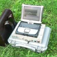
11 Prism2.59 GPR SOFTWARE Prism 2.59 software is designed for georadar parameter control, sounding data reception with simultaneous computer display and record to the hard drive, as well as for file processing and printout. Supports English, German, Greek, Korean, Russian or Chinese languages. Software Advantages User-friendly interface Colored or grayscale data representation Continuos or stepped mode Data storing in origanl shape with digital gain and filter real-time applying. Different positioning methods (Wheel, GPS,...) GPS coordinates editing, import and export Spectra calculations Stepped Undo/Redo and Zomm In/Zoom Out Frequency bandpass filtering Efficient amplitude correction Velocities and depth evaluation via difracting options Migration & Envelope Topography recalculations SEG-Y data format with data Import/Export possibilities


12
GPR SURVEY METHOD. Ground probing radar
 The ground penetrating radar (GPR - Ground Probing Radar) is a geophysical method used to investigate the near surface underground. Thanks to its high degree of resolution, the GPR is the most effective
GPR Data Acquisition and Interpretation
 1 GPR Data Acquisition and Interpretation Mezgeen Rasol PhD Candidate Geophysics and Seismic Engineering Polytechnic University of Catalonia mezgeen.rasol@upc.edu BIG-SKY-EARTH Cost Action TD143 Workshop
GeoRadar Division. GPR for Archeology and Cultural Heritage. GeoRadar Division. GPR Configuration for Archeology and Cultural Heritage Application
 GeoRadar Division GPR Configuration for Archeology and Cultural Heritage Application We believe that the Archaeological patrimony and the Cultural Heritage are one of the most important aspect of this
Ground Penetrating Radar (GPR) By Dr. Eng. Zubair Ahmed
 By Dr. Eng. Zubair Ahmed") Ground Penetrating Radar (GPR) By Dr. Eng. Zubair Ahmed Acknowledgement Golder Associates, Whitby, Ontario Stantec Consulting, Kitchener, Ontario Infrasense Inc. USA Geophysical Survey Systems Inc. (GSSI),
Ground Penetrating Radar (GPR) By Dr. Eng. Zubair Ahmed Acknowledgement Golder Associates, Whitby, Ontario Stantec Consulting, Kitchener, Ontario Infrasense Inc. USA Geophysical Survey Systems Inc. (GSSI),
GPR SYSTEM USER GUIDE AND TROUBLESHOOTING GUIDE
 GPR SYSTEM USER GUIDE AND TROUBLESHOOTING GUIDE Implementation Report 5-4414-01-1 Project Number 5-4414-01 Subsurface Sensing Lab Electrical and Computer Engineering University of Houston 4800 Calhoun
Assessment of layer thickness and uniformity in railway embankments with Ground Penetrating Radar
 Assessment of layer thickness and uniformity in railway embankments with Ground Penetrating Radar F.M. Fernandes Department of Civil Engineering, University of Minho, Guimarães, Portugal M. Pereira Geotechnique
COBRA CBD UNPARALLELED QUALITY GPR DATA WITHOUT BLIND SPOTS
 COBRA CBD WIRELESS GPR Introducing the smart CBD ANTENNA Triple frequency 200/400/800 MHz Outstanding 50-1400 MHz bandwidth Replaces several conventional antennas UNPARALLELED QUALITY GPR DATA WITHOUT
L O C A T O R G P R. Introducing the. Radarteam. Ground Probing Radar/Antenna system with Rugged PC and Cart ü
 Introducing the L O C A T O R G P R Ground Probing Radar/Antenna system with Rugged PC and Cart ü Fully integrated system. Multi Frequency operation: 100-900 MHz ü Air/Ground Coupled operation. Multiple
Noggin Competitive Analysis. Copyright 2016, Sensors & Software Copyright 2015, Sensors & Software
 Noggin Competitive Analysis Copyright 2015, Sensors & Software Competitive Analysis why do it? Understand the market place & build our product knowledge Learn how we compare Help identify our unique selling
Results of GPR survey of AGH University of Science and Technology test site (Cracow neighborhood).
.") Results of GPR survey of AGH University of Science and Technology test site (Cracow neighborhood). October 02, 2017 Two GPR sets were used for the survey. First GPR set: low-frequency GPR Loza-N [1]. Technical
Results of GPR survey of AGH University of Science and Technology test site (Cracow neighborhood). October 02, 2017 Two GPR sets were used for the survey. First GPR set: low-frequency GPR Loza-N [1]. Technical
Ground Penetrating Radar
 REPORT 4A Ground Penetrating Radar Introduction to GPR, and positioning of GPR data Part of R&D project Infrastructure in 3D in cooperation between Innovation Norway, Trafikverket and TerraTec Yta för
The use of high frequency transducers, MHz, allowing the resolution to target a few cm thick in the first half meter suspect.
 METHODOLOGY GPR (GROUND PROBING RADAR). In recent years the methodology GPR (Ground Probing Radar) has been applied with increasing success under the NDT thanks to the high speed and resolving power. As
Geophysical Survey Rock Hill Bleachery TBA Site Rock Hill, South Carolina EP-W EPA, START 3, Region 4 TABLE OF CONTENTS Section Page Signature
 Geophysical Survey Rock Hill Bleachery TBA Site Rock Hill, South Carolina EP-W-05-054 EPA, START 3, Region 4 Prepared for: Tetra Tech EM, Inc. October 12, 2012 Geophysical Survey Rock Hill Bleachery TBA
SIMULATION OF GPR SCENARIOS USING FDTD
 SIMULATION OF GPR SCENARIOS USING FDTD 1 GAMIL ALSHARAHI, 2 ABDELLAH DRIOUACH, 3 AHMED FAIZE 1,2 Department of physic, Abdelmalek Essaâdi University, Faculty of sciences, Morocco 3 Department of physic,
1. Report No. FHWA/TX-05/ Title and Subtitle PILOT IMPLEMENTATION OF CONCRETE PAVEMENT THICKNESS GPR
 1. Report No. FHWA/TX-05/5-4414-01-3 4. Title and Subtitle PILOT IMPLEMENTATION OF CONCRETE PAVEMENT THICKNESS GPR Technical Report Documentation Page 2. Government Accession No. 3. Recipient s Catalog
GPR Investigation: Post Tension Cable Mapping
 CMD Civil Pty Ltd PO Box 1119 Huntingdale VIC 3166 +61 3 9544 8833 info@cmdcivil.com www.cmdcivil.com Case Study: GPR Investigation: Post Tension Cable Mapping This application note demonstrates an example
Applied Geophysics Nov 2 and 4
 Applied Geophysics Nov 2 and 4 Effects of conductivity Surveying geometries Noise in GPR data Summary notes with essential equations Some Case histories EOSC 350 06 Slide 1 GPR Ground Penetrating Radar
GPR Part II: Effects of conductivity. Surveying geometries. Noise in GPR data. Summary notes with essential equations. Some Case histories
 GPR Part II: Effects of conductivity Surveying geometries Noise in GPR data Summary notes with essential equations Some Case histories EOSC 350 06 Slide 1 GPR Ground Penetrating Radar R = ε ε 2 2 + ε ε
Application of Ground Penetrating Radar for River Ice Surveys
 CGU HS Committee on River Ice Processes and the Environment 14th Workshop on the Hydraulics of Ice Covered Rivers Quebec City, June 19-22, 2007 Application of Ground Penetrating Radar for River Ice Surveys
Advanced Ground Investigation Techniques to Help Limit Risk or Examine Failure. Advanced Subsurface Investigations
 Advanced Ground Investigation Techniques to Help Limit Risk or Examine Failure Overview Introduction What is geophysics? Why use it? Common Methods Seismic Ground Radar Electrical Case Studies Conclusion
7. Consider the following common offset gather collected with GPR.
 Questions: GPR 1. Which of the following statements is incorrect when considering skin depth in GPR a. Skin depth is the distance at which the signal amplitude has decreased by a factor of 1/e b. Skin
Tri-band ground penetrating radar for subsurface structural condition assessments and utility mapping
 Tri-band ground penetrating radar for subsurface structural condition assessments and utility mapping D. Huston *1, T. Xia 1, Y. Zhang 1, T. Fan 1, J. Razinger 1, D. Burns 1 1 University of Vermont, Burlington,
3D UTILITY MAPPING USING ELECTRONICALLY SCANNED ANTENNA ARRAY. Egil S. Eide and Jens F. Hjelmstad
 D UTILITY MAPPING USING ELECTRONICALLY SCANNED ANTENNA ARRAY Egil S. Eide and Jens F. Hjelmstad Department of Telecommunications Norwegian University of Science and Technology, N-79 Trondheim, Norway eide@tele.ntnu.no
Opera Duo. GeoRadar Division
 Utilities Detection and Mapping Opera Duo: real-time detection of pipes RIS MF Hi-Mod: Utilities mapping on all zones All rights reserved to IDS 2 Utilities Detection and Mapping Stream: massive arrays
Investigation of Bridge Decks Utilizing Ground Penetrating Radar
 Investigation of Bridge Decks Utilizing Ground Penetrating Radar Steve Cardimona *, Brent Willeford *, John Wenzlick +, Neil Anderson * * The University of Missouri-Rolla, Department of Geology and Geophysics
Estimaton of Rebar Diameter Using Ground Penetrating Radar
 International Journal of Advances in Scientific Research and Engineering (ijasre) E-ISSN : 2454-8006 Vol.3, Special Issue 1 Aug - 2017 Estimaton of Rebar Diameter Using Ground Penetrating Radar K Ambika
GPR ANTENNA ARRAY FOR THE INSPECTION OF RAILWAY BALLAST
 Proceedings of the National Seminar & Exhibition on Non-Destructive Evaluation NDE 2011, December 8-10, 2011 GPR ANTENNA ARRAY FOR THE INSPECTION OF RAILWAY BALLAST Th. Kind BAM Federal Institute for Materials
Utility Locating Terminology & Equipment Guide. Utility Survey Corp.
 Utility Locating Terminology & Equipment Guide Utility Survey Corp. Contents Utility Locating Terminology Utility Locating Toning or Scoping Scanning X Ray the Ground & Ground Penetrating Radar 3 4 5 6
Exploration Beyond Expectation. Geo-Carte Radar Technology Pvt. Ltd.
 Exploration Beyond Expectation Geo-Carte Radar Technology Pvt. Ltd. Problem Unknown distribution network of underground pipeline in India 32% Damage of pre-existing underground utilities during laying
Time Domain Far Field Antenna Measurements Without Anechoic Chamber
 1 Time Domain Far Field Antenna Measurements Without Anechoic Chamber Adjacent Reflecting Objects Transmitting Antenna Antenna Under Test Pulse Generator Head Sampling Unit DC-26GHz Pulse Generator Mainframe
Advanced Utility Locating Technologies (R01B)
") Advanced Utility Locating Technologies (R01B) Jacob Sheehan Senior Geophysicist Olson Engineering Phil Sirles Principal Geophysicist Olson Engineering Introduction: Utility Bundle Overview SHRP2 Strategic
Advanced Utility Locating Technologies (R01B) Jacob Sheehan Senior Geophysicist Olson Engineering Phil Sirles Principal Geophysicist Olson Engineering Introduction: Utility Bundle Overview SHRP2 Strategic
RECONSTRUCTION OF BURIED OBJECTS BY IMPLEMENTATION OF GROUND PENETRATING RADAR TECHNIQUE: EXAMPLE ON ROMAN TOMB IN BRESTOVIK (SERBIA)
") Geoarchaeology and Archaeomineralogy (Eds. R. I. Kostov, B. Gaydarska, M. Gurova). 2008. Proceedings of the International Conference, 29-30 October 2008 Sofia, Publishing House St. Ivan Rilski, Sofia,
Geoarchaeology and Archaeomineralogy (Eds. R. I. Kostov, B. Gaydarska, M. Gurova). 2008. Proceedings of the International Conference, 29-30 October 2008 Sofia, Publishing House St. Ivan Rilski, Sofia,
Ground Penetrating Radar (day 1) EOSC Slide 1
 EOSC Slide 1") Ground Penetrating Radar (day 1) Slide 1 Introduction to GPR Today s Topics Setup: Motivational Problems Physical Properties - Dielectric Permittivity and Radiowaves - Microwave Example Basic Principles:
Ground Penetrating Radar (day 1) Slide 1 Introduction to GPR Today s Topics Setup: Motivational Problems Physical Properties - Dielectric Permittivity and Radiowaves - Microwave Example Basic Principles:
ESTIMATION OF REBAR DIAMETER IN CONCRETE STRUCTURAL ELEMENTS USING GROUND PENETRATING RADAR
 More info about this article: http://www.ndt.net/?id=21143 ESTIMATION OF REBAR DIAMETER IN CONCRETE STRUCTURAL ELEMENTS USING GROUND PENETRATING RADAR Bhaskar Sangoju and Ramanjaneyulu, K. Scientists,
ProEx - Professional Explorer Control Unit. Operating Manual v
 ProEx - Professional Explorer Control Unit Operating Manual v. 2.0 19-001030 Table of Contents 1 Introduction 4 1.1 Unpacking and Inspection 5 1.2 Repacking and Shipping 5 1.3 Important information regarding
Using GPR Technique Assessment for Study the Sub-Grade of Asphalt and Concrete Conditions
 Using GPR Technique Assessment for Study the Sub-Grade of Asphalt and Concrete Conditions Alaa S. Mahdi Remote Sensing Unit, College of Science, University of Baghdad, Baghdad, Iraq Abstract The Ground
Report on a Ground Penetrating Radar survey of Longyearbreen
 Report on a Ground Penetrating Radar survey of Longyearbreen AT-329 Unis, 10.03.2006 Christopher Nuth Karen Klemetsrud Matthias Hofmann Tone Gulliksen Øy Abstract: Ground Penetration Radar was used to
GPR and Scanning Equipment
 1 CONQUEST 100 ON-SITE REPORTS CONQUEST 100 Conquest 100 is a light, portable device that provides a fast, non-invasive method to gain accurate insights of objects below the surface, even on a curved surface
Advances in NDE Technology WHATS NEW?
 Advances in NDE Technology WHATS NEW? Glen Simula, Owner GS Infrastructure, Inc. The state of America s deteriorating infrastructure presses us to find solutions to assess, with limited funds and resources.
GROUND PENETRATING RADAR (GEORADAR) INSPECTION
 INSPECTION") - CIVIL ENGENEERING - GEOLOGY AND ENVIRONMENT - GROUND PENETRATING RADAR - LOSSES DETECTING RADAR SYSTEM - ARCHEOLOGY & CULTURAL HERITAGE - CARGO INSPECTION - LOSS CONTROL - CHEMICAL ANALYSIS - INDUSTRIAL
- CIVIL ENGENEERING - GEOLOGY AND ENVIRONMENT - GROUND PENETRATING RADAR - LOSSES DETECTING RADAR SYSTEM - ARCHEOLOGY & CULTURAL HERITAGE - CARGO INSPECTION - LOSS CONTROL - CHEMICAL ANALYSIS - INDUSTRIAL
use, more powerful, delivers cleaner data with more detail and up to 20% better penetration depth than comparable systems.
 Utility Locating System Easy Locator HDR Pro Terraplus is pleased to introduce the Easy Locator HDR (High Dynamic Range) Pro. The Easy Locator HDR Pro is faster, easier to use, more powerful, delivers
Ground Penetrating Radar: Impulse and Stepped Frequency
 Ground Penetrating Radar: Impulse and Stepped Frequency Carey M. Rappaport Professor Elect. and Comp. Engineering Northeastern University CenSSIS Workshop SW3, November 15, 2 Center for Subsurface Sensing
70cm & Microwave Amateur TV Frequencies Jim Andrews, KH6HTV
 AppNote10a-TVfreqs.doc (kh6htv, 10/31/2014) p. 1 of 5 Application Note AN-10a copyright - Nov. 2011 rev. - Oct. 2014 70cm & Microwave Amateur TV Frequencies Jim Andrews, KH6HTV www.kh6htv.com Licensed
GPR Inspection of Bridge Decks
 All rights reserved including the right of reproduction in whole or in part in any form Published by Geophysical Survey Systems, Inc. 40 Simon St. Nashua, New Hampshire 03060 USA Printed in the United
Radar Methods General Overview
 Environmental and Exploration Geophysics II Radar Methods General Overview tom.h.wilson tom.wilson@mail.wvu.edu Department of Geology and Geography West Virginia University Morgantown, WV Brown (2004)
ωκε ωκε 5.11 Ground Penetrating Radar (GPR)
") 5. Ground Penetrating Radar (GPR) The plane wave solutions we have studied so far have been valid for frequencies and conductivities such that the conduction currents dominate the displacement currents
5. Ground Penetrating Radar (GPR) The plane wave solutions we have studied so far have been valid for frequencies and conductivities such that the conduction currents dominate the displacement currents
GROUND PENETRATING RADAR SURVEYS ON RAILWAY SECTION BETWEEN MONTEVIDEO PASO DE LOS TOROS URUGUAY
 GROUND PENETRATING RADAR SURVEYS ON RAILWAY SECTION BETWEEN MONTEVIDEO PASO DE LOS TOROS URUGUAY 0 Name of the report 2017 / 2 GROUND PENETRATING RADAR SURVEY ON RAILWAY SECTION BETWEEN MONTEVIDEO PASO
PILOT-FI NEW. Pilot-FI Field Interface Operator s Manual
 PILOT-FI NEW Pilot-FI Field Interface Operator s Manual Table of Contents OVERVIEW...2 alarms...3 No Modules Installed No Central Detected DISPLAY SETTING...5 Language Setting Display Contrast COMMunication
ALIS. Project Identification Project name Acronym
 ALIS Project Identification Project name ALIS Acronym Advanced Landmine Imaging System Participation Level National (Japanese) Financed by JST(Japan Science and Technology Agency) Budget N/A Project Type
RADAR INSPECTION OF CONCRETE, BRICK AND MASONRY STRUCTURES
 RADAR INSPECTION OF CONCRETE, BRICK AND MASONRY STRUCTURES C.P.Hobbs AEA Industrial Technology Materials and Manufacturing Division Nondestructive Testing Department Building 447 Harwell Laboratory Oxon
L A N D R A Y P R O D U C T 1 BREAKTHROUGH PERFORMANCE BY GROUND PENETRATING RADAR
 L A N D R A Y P R O D U C T 1 BREAKTHROUGH PERFORMANCE BY GROUND PENETRATING RADAR 03.2009 Contents LandRay s Business Purpose 3 NEW GENERATION System Requisites 4 LandRay PRODUCT1 best Addresses Unmet
Determine the Thickness of Pavement Layers Variety Using GPR Technique in Some Sites at University of Kufa, Najaf, Iraq
 International Journal of ChemTech Research CODEN (USA): IJCRGG, ISSN: 0974-4290, ISSN(Online):2455-9555 Vol.10 No.2, pp 837-843, 2017 Determine the Thickness of Pavement Layers Variety Using GPR Technique
Ground Penetrating Radar
 Ground Penetrating Radar Begin a new section: Electromagnetics First EM survey: GPR (Ground Penetrating Radar) Physical Property: Dielectric constant Electrical Permittivity EOSC 350 06 Slide Di-electric
ScienceDirect. A comparison of dielectric constants of various asphalts calculated from time intervals and amplitudes
 Available online at www.sciencedirect.com ScienceDirect Procedia Engineering 111 (2015 ) 660 665 XXIV R-S-P seminar, Theoretical Foundation of Civil Engineering (24RSP) (TFoCE 2015) A comparison of dielectric
Case Studies and Innovative Uses of GPR for Pavement Engineering Applications
 Case Studies and Innovative Uses of GPR for Pavement Engineering Applications Richard Korczak, MASc., P.Eng., Stantec Consulting Ltd. Amir Abd El Halim, PhD., P.Eng., Stantec Consulting Ltd. Paper prepared
REBAR DETECTION USING GPR: AN EMERGING NON DESTRUCTIVE QC APPROACH
 REBAR DETECTION USING GPR: AN EMERGING NON DESTRUCTIVE QC APPROACH D.C.Bala*, R.D.Garg** and S.S. Jain*** *(Research scholar, Centre for Transportation Systems (CTRANS), IIT Roorkee, Roorkee-247667, India
Report. Mearns Consulting LLC. Former Gas Station 237 E. Las Tunas Drive San Gabriel, California Project # E
 Mearns Consulting LLC Report Former Gas Station 237 E. Las Tunas Drive San Gabriel, California Project #1705261E Charles Carter California Professional Geophysicist 20434 Corisco Street Chatsworth, CA
Downloaded from library.seg.org by on 10/26/14. For personal use only. SEG Technical Program Expanded Abstracts 2014
 Ground penetrating abilities of broadband pulsed radar in the 1 70MHz range K. van den Doel, Univ. of British Columbia, J. Jansen, Teck Resources Limited, M. Robinson, G. C, Stove, G. D. C. Stove, Adrok
Archaeo-Geophysical Associates, LLC
 Geophysical Survey at the Parker Cemetery Rockwall, Texas. AGA Report 2010-6 Report Submitted To: Texas Cemetery Restoration 10122 Cherry Tree Dr. Dallas, Texas 75243 May 14, 2010 Chester P. Walker, Ph.D.
Experiment on Artificial Frozen Soil Boundary GPR Detection During Cross-passage Construction in Tunnels
 354 Progress In Electromagnetics Research Symposium 2005, Hangzhou, China, August 22-26 Experiment on Artificial Frozen Soil Boundary GPR Detection During Cross-passage Construction in Tunnels Yong-Hui
In search of a Historic Grave: GPR Investigation near the Yellowstone Lake Store: 7/15/2010
 In search of a Historic Grave: GPR Investigation near the Yellowstone Lake Store: 7/15/2010 Steven Sheriff Professor of Geophysics Department of Geosciences University of Montana Missoula, Montana Introduction
Some Advances in UWB GPR
 Some Advances in UWB GPR Gennadiy Pochanin Abstract A principle of operation and arrangement of UWB antenna systems with frequency independent electromagnetic decoupling is discussed. The peculiar design
Using ground penetrating radar to quantify changes in the fracture pattern associated with a simulated rockburst experiment
 Using ground penetrating radar to quantify changes in the fracture pattern associated with a simulated rockburst experiment by M. Grodner* Synopsis Ground Penetrating Radar (GPR) is an electromagnetic
Fundamental Study on NDT of Building Wall Structure by Radar
 7th European Workshop on Structural Health Monitoring July 8-11, 2014. La Cité, Nantes, France More Info at Open Access Database www.ndt.net/?id=17135 Fundamental Study on NDT of Building Wall Structure
Ground penetrating radar in reflection vs transmission mode for void detection in concrete structure
 More Info at Open Access Database www.ndt.net/?id=18279 Ground penetrating radar in reflection vs transmission mode for void detection in concrete structure Christiane TRELA, Thomas KIND 1, Martin GÜNTHER
Pitfalls in GPR Data Interpretation: Differentiating Stratigraphy and Buried Objects from Periodic Antenna and Target Effects
 GEOPHYSICAL RESEARCH LETTERS, VOL. 27, NO. 20, PAGES 3393-3396, OCTOBER 15, 2000 Pitfalls in GPR Data Interpretation: Differentiating Stratigraphy and Buried Objects from Periodic Antenna and Target Effects
Amplitudes Variation of GPR Rebar Reflection Due to the Influence of Concrete Aggregate Scattering
 More Info at Open Access Database www.ndt.net/?id=18402 Amplitudes Variation of GPR Rebar Reflection Due to the Influence of Concrete Aggregate Scattering Thomas KIND Federal Institute for Materials Research
Electromagnetic Induction
 Electromagnetic Induction Recap the motivation for using geophysics We have problems to solve Slide 1 Finding resources Hydrocarbons Minerals Ground Water Geothermal Energy SEG Distinguished Lecture slide
RD1000 Ground Probing Radar
 RD1000 Ground Probing Radar CONTENTS Product Introduction Product Features Competitor Analysis Customers Models, Pricing & Availability Promotional Material Practical Demonstration What to do now Summary
SIR, UtilityScan and RADAN are registered trademarks of Geophysical Survey Systems, Inc.
 Copyright 2016-2017 Geophysical Survey Systems, Inc. All rights reserved including the right of reproduction in whole or in part in any form Published by Geophysical Survey Systems, Inc. 40 Simon Street
SUBSURFACE MAPPING. Presenters: Thomas Kevin Hanna, PLS. Paul J. Emilius Jr., PLS CP
 SUBSURFACE MAPPING Presenters: Thomas Kevin Hanna, PLS Paul J. Emilius Jr., PLS CP February 2 nd 2011 1 Existing Underground Utilities Abound! Power, Telecommunications, Gas/Propane, Petroleum, Sanitary
Determination Variety of Pavement Layers Thickness by Using Ground Penetration Radar Technology
 Layers Thickness by Using Ground Mundher Ali Seger* Received on:9/3/2010 Accepted on:2/9/2010 Abstract Ground penetrating radar (GPR) is a high-frequency electromagnetic method commonly applied to a number
What is an AREDN Mesh Network! Bob Nobis N7RJN Tri-City ARA March 19, 2018
 What is an AREDN Mesh Network! Bob Nobis N7RJN Tri-City ARA March 19, 2018 The AREDN Project s focus is Emergency Communications (EmComm). It seeks to provide hams a means to implement this technology
THE CONNECTED INFRASTRUCTURE SOLUTION MONITORING HOW STRUCTURES EVOLVE
 THE CONNECTED INFRASTRUCTURE SOLUTION MONITORING HOW STRUCTURES EVOLVE Loadsensing is a data acquisition and monitoring system which combines state-of-the-art wireless monitoring and advanced software
Dive deep into interference analysis
 Dive deep into interference analysis Dive deep into interference analysis Contents 1. Introducing Narda Outstanding features 2. Basics IDA 2 3. IDA 2 presentation How IDA 2 is used: 1) Detect 2) Analyze
EVALUATING THE EFFECTIVENESS OF HYPERSTACKING FOR GPR SURVEYS. Abstract
 EVALUATING THE EFFECTIVENESS OF HYPERSTACKING FOR GPR SURVEYS Dr. Jeffrey Feigin, GSSI, Nashua, NH Dr. David Cist, GSSI, Nashua, NH Abstract Although some benefits of Real-Time Sampling (RTS) for Ground
Easy Locator HDR. Terraplus Inc. 52 West Beaver Cr. Rd. #12, Richmond Hill, ON. Canada L4B 1L9. Utility Locating System
 Utility Locating System Easy Locator HDR Terraplus is pleased to introduce the Easy Locator HDR (High Dynamic Range). The Easy Locator HDR is faster, easier to use, more powerful, delivers cleaner data
Resolution in evaluation of structural elements by using ground-penetrating radar.
 Resolution in evaluation of structural elements by using ground-penetrating radar. V. Perez-Gracia Departamento de Resistencia de Materiales y Estructuras en la Ingeniería. EUETIB/CEIB. Universidad Politécnica
SCANNING METHOD. Olson Instruments Impact Echo Scanner. incorporating source and receiver. Overlay. Sound joint between. overlay and bridge deck
 IE Method N D E I M P A C T E C H O S C A N N I N G A PPLICATION Impact Echo (IE) investigations are performed to assess the condition of slabs, beams, columns, walls, pavements, runways, tunnels, and
On the Use of Ground Penetrating Radar to Detect Rebar Corrosion in Concrete Structures
 On the Use of Ground Penetrating Radar to Detect Rebar Corrosion in Concrete Structures David Eisenmann, CNDE, ISU Frank J. Margetan, CNDE, ISU Shelby Ellis, ISU This work is supported by the Iowa DOT
GROUND PENETRATING RADAR (GPR)
") Introduction GROUND PENETRATING RADAR (GPR) (After Basson 2000) GPR is an electromagnetic (EM) geophysical method for high-resolution detection, imaging and mapping of subsurface soils and rock conditions.
Introduction GROUND PENETRATING RADAR (GPR) (After Basson 2000) GPR is an electromagnetic (EM) geophysical method for high-resolution detection, imaging and mapping of subsurface soils and rock conditions.
MULTI-CHANNEL ULTRASONIC FLAW DETECTOR ОКО-22М-UT THE BEST INDUSTRIAL OEM SOLUTION FOR IN-LINE AND IN-SERVICE SYSTEMS
 MULTI-CHANNEL ULTRASONIC FLAW DETECTOR ОКО-22М-UT THE BEST INDUSTRIAL OEM SOLUTION FOR IN-LINE AND IN-SERVICE SYSTEMS www.ndt.com.ua PURPOSE OKO-22M-UT PRO WIRELESS INTERFACE WI-FI The ОКО-22М-UT ultrasonic
Chapter-15. Communication systems -1 mark Questions
 Chapter-15 Communication systems -1 mark Questions 1) What are the three main units of a Communication System? 2) What is meant by Bandwidth of transmission? 3) What is a transducer? Give an example. 4)
S u b s i t e L o c at o r s
 S u b s i t e L o c at o r s > 950R/T > 970T > 910R > EML System > AF2/ft14 > 2150GR S U B S I T E 9 5 0 R / t a n d 9 7 0 T P i p e a n d c a b l e l o c at o r s y s t e m Location, location, location.
Regarding RF Isolation for small Enclosures
 Regarding RF Isolation for small Enclosures IEEE electromagnetic society and IEEE standard board has published standards for measuring the shielding effectiveness (SE) of chambers. The measurement methods
GeoRadar Division A HISTORY OF PROVIDING HIGH TECHNOLOGY. IDS s Pisa Headquarters
 A HISTORY OF PROVIDING HIGH TECHNOLOGY IDS s Pisa Headquarters Subsidiary and office across four continents IDS Tech (Ottawa) IDS North America (Montréal) IDS UK (Fareham) Sistemi Dinamici A joint venture
Strategic City Wide Mapping of Underground Assets using Ground Penetrating Radar. Mark Bell
 Strategic City Wide Mapping of Underground Assets using Ground Penetrating Radar Mark Bell XXV International Federation of Surveyors Congress, Kuala Lumpur, Malaysia, 16 21 June 2014 TOPICS GPR background
Opera Duo. Opera Duo. GeoRadar Division. a first class underground survey
 a first class underground survey Opera Duo Competitive advantages Designed around you A large, comfortable handle to make pushing an pulling easier, large wheels for better control and a balanced weight
MICROWAVE SCATTERING FOR THE CHARACTERIZATION OF A DISC-SHAPE VOID IN DIELECTRIC MATERIALS AND COMPOSITES
 MICROWAVE SCATTERING FOR THE CHARACTERIZATION OF A DISC-SHAPE VOID IN DIELECTRIC MATERIALS AND COMPOSITES John M. Liu Code 684 Naval Surface Warfare Center Carderock Div. West Bethesda, Md. 20817-5700
A Mode Based Model for Radio Wave Propagation in Storm Drain Pipes
 PIERS ONLINE, VOL. 4, NO. 6, 008 635 A Mode Based Model for Radio Wave Propagation in Storm Drain Pipes Ivan Howitt, Safeer Khan, and Jumanah Khan Department of Electrical and Computer Engineering The
LAB 9: GROUND-PENETRATING RADAR
 NAME: LAB TIME: LAB 9: GROUND-PENETRATING RADAR The following lab will introduce you to the basic concepts of Ground-Penetrating Radar (GPR) in part I. In part II, we will conduct a field geophysical survey
SUBSURFACE INSTRUMENTS, INC. AML PRO & AML+ PRODUCT GUIDE
 SUBSURFACE INSTRUMENTS, INC. AML PRO & AML+ PRODUCT GUIDE Advanced Underground PVC Pipe Detection Patented Technology Advanced PVC & PE Pipe Detection FCC, IC & EU/CE Approved www.ssilocators.com INTRODUCING
Using Malå GPR systems with GPS equipment
 Using Malå GPR systems with GPS equipment Description of problem In many situations it is convenient to use a GPS to keep track of the position in terms of x- and y-coordinates for all measured GPR profiles.
CX and HF antennas. Operating manual. Main unit for the MALÅ Geoscience High frequency antenna series. Version
 CX and HF antennas Main unit for the MALÅ Geoscience High frequency antenna series Operating manual Version 2.7 19-001024 Table of Contents 1 Introduction 4 1.1 Unpacking and Inspection 5 1.2 Repacking
Set No.1. Code No: R
 Set No.1 IV B.Tech. I Semester Regular Examinations, November -2008 RADAR SYSTEMS ( Common to Electronics & Communication Engineering and Electronics & Telematics) Time: 3 hours Max Marks: 80 Answer any
THE ROLE OF LOZA RADAR IN EXPLORATION
 www.lozaradar.com THE ROLE OF LOZA RADAR IN EXPLORATION 25 MINUTES NOVEMBER 2016 Georadar development at IZMIRAN and mathematical aspects of subsurface radio probing Introduction LOZA GPR series Applications
RADAR SENSOR FOR INTRUSION AND OBSTACLES DETECTION
 SECURITY SYSTEMS RADAR SENSOR FOR INTRUSION AND OBSTACLES DETECTION In security you cannot choose the second best option indracompany.com DIO RADAR SENSOR FOR INTRUSION AND OBSTACLES DETECTION A medium-range
Form DOT F (8-72) This form was electrically by Elite Federal Forms Inc. 16. Abstract:
 This form was electrically by Elite Federal Forms Inc. 16. Abstract:") 1. Report No. FHWA/TX-06/0-4820-3 4. Title and Subtitle Investigation of a New Generation of FCC Compliant NDT Devices for Pavement Layer Information Collection: Technical Report 2. Government Accession
1. Report No. FHWA/TX-06/0-4820-3 4. Title and Subtitle Investigation of a New Generation of FCC Compliant NDT Devices for Pavement Layer Information Collection: Technical Report 2. Government Accession
HGD HURRICANE 2010 / 2011
 HGD HURRICANE 2010 / 2011 The Global Surprise For the Treasures Hunters, Prospecting Amateurs, for all Researchers for Gold and Underground Metals Introduction: The Modern scientific Innovation, Exclusive
A Single Display for RASCAN 5-frequency 2-polarisation Holographic Radar Scans
 PIERS ONLINE, VOL. 5, NO. 5, 2009 496 A Single Display for RASCAN 5-frequency 2-polarisation Holographic Radar Scans C. G. Windsor 1, A. Bulletti 2, L. Capineri 2, P. Falorni 2, S. Valentini 2, G. Borgioli