GROUND PENETRATING RADAR (GEORADAR) INSPECTION
|
|
|
- Andrea Morgan
- 5 years ago
- Views:
Transcription
1 - CIVIL ENGENEERING - GEOLOGY AND ENVIRONMENT - GROUND PENETRATING RADAR - LOSSES DETECTING RADAR SYSTEM - ARCHEOLOGY & CULTURAL HERITAGE - CARGO INSPECTION - LOSS CONTROL - CHEMICAL ANALYSIS - INDUSTRIAL SYSTEMS AND TECNOLOGY - RESEARCH GROUND PENETRATING RADAR (GEORADAR) INSPECTION PREFACE... 2 GEORADAR OPERATING PRINCIPLE... 5 OPERATING MODE ON LINES AND PIPELINES... 8 IDENTIFICATION OF SPILL USING GAS TRACERS OPERATING MODE FOR STRUCTURAL CHECKS OPERATIONAL MODE FOR ATMOSPHERIC TANKS REFERENCES Head Off. I Catania, Via Cagliari, 56 T: +39 (095) F: +39 (095) M: info@pccgroup.it T: +39 (095) Via Delle Ginestre Zafferana Etnea (CT) P.IVA REA CT
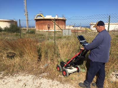
2 PREFACE Geoadar is an electronic system, able to indicate grounds and materials with considerable details, using the reflection of electromagnetic waves produced by the system. The analysis result is made from tomograms that visually illustrate trends of the discontinuities in the subsurface, thus allowing to detect the presence of metal materials, concrete foundations, pipes, cables, cavities, but also leakage of fluids (spills) in general (water, hydrocarbons, waste water, sewage oily...) and in-homogeneities of various kinds. The survey is carried out using the MCH SMA ISV system, comprising: Radar Control System Antenna sensors Radar Control system The radar control system is composed by: Radar control unit DAD (Digital Antenna Driver) Responsible for the generating of antennas control pulses. Technical characteristics of the DAD are as follows: Scan Rate:> 850 Scan / rate Range:> 9999 nsec. Hw Architecture: 16bit Number of samples per scanning: Number of radar channels: 4ch Lan, Battery 2


3 Figure.1 DAD Laptop For control and saving of radar data using the K2 software in charge of radar information management. Figure.2 Laptop for management of radar data. Antenna Sensors Antenna sensors used for prospecting consists of: TR SMA Antenna Consists of 4 radar sensors with 200MHz and 600MHz antennas for surface investigation and suitable for evaluation of underground utilities presence and for the ground saturation condition assessment. 3


4 Figure.3 TR SMA Antenna used for radar prospecting Figure.4- TR SMA Antenna during investigation 4
5 GEORADAR OPERATING PRINCIPLE All real objects absorb electromagnetic waves depending on own electrical characteristics. A homogeneous medium, partially conductor, is defined, as electric point of view, with a pair of values: dielectric constant conductivity Subsoil consists of a heterogeneous medium whose dielectric characteristics are determinant for the identification of well-defined and interpretable signals. The electromagnetic wave generated by the radar is emitted into the ground by a transmitter inside the antenna. When the electromagnetic waves encounter a physical discontinuity, part of the incident energy is reflected, generating a pulse, which is collected by a receiver, with a shape similar to that transmitted but attenuated and distorted in phase and frequency. The transmitted pulse shape is appropriately calibrated so as to obtain a spectral distribution of Gaussian type with the central value that represents the characteristic frequency, or center frequency of the antenna, which corresponds to the dominant frequency of the pulse. The central frequency of the antenna determines the characteristics of resolution and maximum achievable exploration depth. Antennas can operate in three main ways: monostatic arrangement; bistatic arrangement; cross-polar arrangement. 5
6 With the monostatic arrangement, transmitter and receiver are assembled into a single structure, allowing to obtain information throughout the investigated area and to determine the depth of targets. This arrangement is recommended for superficial information such as services and archaeological finds with medium-high-frequency antennas ( MHz). With the bistatic arrangement, transmitter and receiver are separated and placed at a certain distance from each other. The benefit is a more detailed response in the deeper areas, while the disadvantage is the absence of response when the two components are too far from each other. This arrangement is recommended to obtain information from deep areas and is generally used with medium-low-frequency antennas ( MHz) and geological purposes. With the cross-polar arrangement, transmitter and receiver are mutually orthogonal. This arrangement is particularly useful in the detection of targets oblique inclined relative to the direction of antennas movement and, in general, also for special scientific applications. The radar sections represent the results of GPR surveys. The horizontal axis reproduces the direction of the antenna advancement, while the vertical axis represents the direction of pulses penetration. This distance is expressed as delay between the pulse emitted and the reflected one and is equal to two times the antenna-target distance. The delay value is converted into metric value by using the signal propagation speed in the medium. 6

7 Figure.5- Georadar Operating principle The radar display of a target present in the subsoil is shown in Figure 5. The radar signal received by the antenna is always characterized by the presence of "noise" that must be removed in order to emphasize as much as possible the visibility of the wanted targets. Then there are several processing procedures where the signal is subjected before the data interpretation stage. The following are some of the main processes used: Vertical filtering: Every single radar track contains a set of peaks that have a specified period. The purpose of the filtering in the time domain (vertical filtering) is to remove all spurious frequencies, that are not connected to targets present in the subsoil. Horizontal filtering: The set of traces connected with a given structure defines a horizontal frequency; the aim of the horizontal filtering (spatial domain) is to remove the low frequencies (parallel bands) which are not connected to any structure, but which are generated in the area between the antenna and the surface. Migration: Operation used for underground utilities search. In fact, thanks to the strong peripheral sensitivity of the radar antennas, the underground utilities generate reflection with hyperbolic trend and the migration process removes the tails of these hyperboles, keeping only the top point corresponding to the target locatio. In this way it is possible the detection of very near services, which otherwise would provide a very confusing reflection due to the multiple reflections. 7
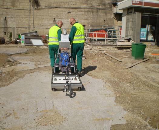
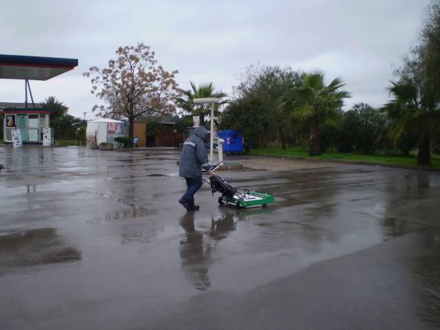
8 OPERATING MODE ON LINES AND PIPELINES Once the area in which the line to be investigated is situated, as a function of the length, it is divided into sectors to facilitate the software processing of the acquired radar data (see eg. Figure 6) Figure.6- Example of subdivision into different sectors Then, are carried out a number of longitudinal and transverse scans along the road or the surveyed area, sufficient to obtain a good cover (usually scans with arrays of 1 meter both longitudinally and transversely). x y Figure.7- Individual scans viewing The volume investigated is subsequently subjected to tomographic analysis that returns images at different depths on the x, y plane (see Fig. 8). The spacing between subsequent scans may vary depending on the aims. 8


9 Figure.8- Radar tomography at different depths. Fig.9- CAD identification of subservices 9


10 Figure10- Radar map identification of three different underground services Figure.11- Example of 3D display of identified underground utilitie. 10

11 11 Figure.12- Display of longitudinal and transverse scans.

12 IDENTIFICATION OF SPILL USING GAS TRACERS This technology is used to support Georadar. Tracer Tight is the precision integrity testing service that identifies and locates leaks to a high level of sensitivity. The system is able to identify leaks as small as one liter per day. It identifies and locates leaks in underground piping and bulk storage tanks. It uses inert tracer gases that are placed in the contents of the tank or in the line to be check for leaks. In case of leaks, these gases give response thanks to special sensors, properly installed, which qualify the extent and exact location of the spill. This test consists of the following steps: Emptying line; Identification of the line with Georadar system and / or Locator Probes making Measuring the presence of tracer gas in the environment; Insufflation of tracer gas; Relief on ground level to locate the leak. Measurements are made with a mass spectrometer, autonomous and portable, designed so as to have the same sensitivity and selectivity of a laboratory common mass spectrometer. The spectrometer draws a certain amount of air per second, it ionizes all the molecules and allows only ionized trace gas molecules to pass through an electromagnetic mirror system, generating an ion current. These ionized molecules are collected on a collector and the electric current that follows is amplified and digitized to obtain the result. Fig.13- Leaks verifing 12


13 OPERATING MODE FOR STRUCTURAL CHECKS Using special radar antennas is possible to investigate concrete structures such as basin, bridges, tanks, pillars, walls as well as submerged structures. The greater detail of radargrams obtained with very high frequency antennas enables to identify micro-cracks inside the structure and possible hidden deteriorations. Figure.14- Concrete reinforcement detection Figure.15- Structural check of submerged wall 13

14 14 Fig.16- Structural check of submerged wall
15 OPERATIONAL MODE FOR ATMOSPHERIC TANKS After installing a series of piezometers below the investigated tank, a series of scans are performed with a special radar antenna designed for the specific purpose. These scans have the main purpose of identifying ground areas at different dielectric capacity where tank is installed and through the display and overexposure of tomographic maps identify any spills. The following figures show the investigative mode. Figure.17- Probes Arrangement Figure.18- Containment basin inspection 15


16 Fig.19- tank bottom scanning Figure.20-tomography of tank bottom scans 16
17 REFERENCES ENI SpA VERSALIS SpA ERG SpA ISAB srl SARAS SpA API SpA ENIMED SpA CONSORZIO DI BONIFICA CATANIA RAFFINERIA DI GELA SpA RAFFINERIA DI MILAZZO SpA KUWAIT PETROLEUM ITALIA SpA ESSO RETE DISTRIBUZIONE PRIOLO SERVIZI ENEL DISTRIBUZIONE SpA ALFA CONSULTING SASOL 17
GPR SURVEY METHOD. Ground probing radar
 The ground penetrating radar (GPR - Ground Probing Radar) is a geophysical method used to investigate the near surface underground. Thanks to its high degree of resolution, the GPR is the most effective
SIMULATION OF GPR SCENARIOS USING FDTD
 SIMULATION OF GPR SCENARIOS USING FDTD 1 GAMIL ALSHARAHI, 2 ABDELLAH DRIOUACH, 3 AHMED FAIZE 1,2 Department of physic, Abdelmalek Essaâdi University, Faculty of sciences, Morocco 3 Department of physic,
GeoRadar Division. GPR for Archeology and Cultural Heritage. GeoRadar Division. GPR Configuration for Archeology and Cultural Heritage Application
 GeoRadar Division GPR Configuration for Archeology and Cultural Heritage Application We believe that the Archaeological patrimony and the Cultural Heritage are one of the most important aspect of this
The use of high frequency transducers, MHz, allowing the resolution to target a few cm thick in the first half meter suspect.
 METHODOLOGY GPR (GROUND PROBING RADAR). In recent years the methodology GPR (Ground Probing Radar) has been applied with increasing success under the NDT thanks to the high speed and resolving power. As
P Forsmark site investigation. RAMAC and BIPS logging in borehole HFM11 and HFM12
 P-04-39 Forsmark site investigation RAMAC and BIPS logging in borehole HFM11 and HFM12 Jaana Gustafsson, Christer Gustafsson Malå Geoscience AB/RAYCON March 2004 Svensk Kärnbränslehantering AB Swedish
Geophysical Survey Rock Hill Bleachery TBA Site Rock Hill, South Carolina EP-W EPA, START 3, Region 4 TABLE OF CONTENTS Section Page Signature
 Geophysical Survey Rock Hill Bleachery TBA Site Rock Hill, South Carolina EP-W-05-054 EPA, START 3, Region 4 Prepared for: Tetra Tech EM, Inc. October 12, 2012 Geophysical Survey Rock Hill Bleachery TBA
GPR Data Acquisition and Interpretation
 1 GPR Data Acquisition and Interpretation Mezgeen Rasol PhD Candidate Geophysics and Seismic Engineering Polytechnic University of Catalonia mezgeen.rasol@upc.edu BIG-SKY-EARTH Cost Action TD143 Workshop
Exploration Beyond Expectation. Geo-Carte Radar Technology Pvt. Ltd.
 Exploration Beyond Expectation Geo-Carte Radar Technology Pvt. Ltd. Problem Unknown distribution network of underground pipeline in India 32% Damage of pre-existing underground utilities during laying
VALIDATION OF GROUND PENETRATING RADAR DATA INTERPRETATION USING AN ELECTROMAGNETIC WAVE PROPAGATION SIMULATOR
 Romanian Reports in Physics, Vol. 68, No. 4, P. 1584 1588, 2016 VALIDATION OF GROUND PENETRATING RADAR DATA INTERPRETATION USING AN ELECTROMAGNETIC WAVE PROPAGATION SIMULATOR A. CHELMUS National Institute
Pitfalls in GPR Data Interpretation: Differentiating Stratigraphy and Buried Objects from Periodic Antenna and Target Effects
 GEOPHYSICAL RESEARCH LETTERS, VOL. 27, NO. 20, PAGES 3393-3396, OCTOBER 15, 2000 Pitfalls in GPR Data Interpretation: Differentiating Stratigraphy and Buried Objects from Periodic Antenna and Target Effects
Identification of Pipelines from the Secondary Reflect Wave Travel Time of Ground-Penetrating Radar Waves
 Journal of Emerging Trends in Engineering and Applied Sciences (JETEAS) 2 (5): 770-774 Scholarlink Research Institute Journals, 2011 (ISSN: 2141-7016) jeteas.scholarlinkresearch.org Journal of Emerging
Ground Penetrating Radar
 Ground Penetrating Radar Begin a new section: Electromagnetics First EM survey: GPR (Ground Penetrating Radar) Physical Property: Dielectric constant Electrical Permittivity EOSC 350 06 Slide Di-electric
Report. Mearns Consulting LLC. Former Gas Station 237 E. Las Tunas Drive San Gabriel, California Project # E
 Mearns Consulting LLC Report Former Gas Station 237 E. Las Tunas Drive San Gabriel, California Project #1705261E Charles Carter California Professional Geophysicist 20434 Corisco Street Chatsworth, CA
GPR SYSTEM USER GUIDE AND TROUBLESHOOTING GUIDE
 GPR SYSTEM USER GUIDE AND TROUBLESHOOTING GUIDE Implementation Report 5-4414-01-1 Project Number 5-4414-01 Subsurface Sensing Lab Electrical and Computer Engineering University of Houston 4800 Calhoun
7. Consider the following common offset gather collected with GPR.
 Questions: GPR 1. Which of the following statements is incorrect when considering skin depth in GPR a. Skin depth is the distance at which the signal amplitude has decreased by a factor of 1/e b. Skin
Ground Penetrating Radar (day 1) EOSC Slide 1
 EOSC Slide 1") Ground Penetrating Radar (day 1) Slide 1 Introduction to GPR Today s Topics Setup: Motivational Problems Physical Properties - Dielectric Permittivity and Radiowaves - Microwave Example Basic Principles:
Ground Penetrating Radar (day 1) Slide 1 Introduction to GPR Today s Topics Setup: Motivational Problems Physical Properties - Dielectric Permittivity and Radiowaves - Microwave Example Basic Principles:
Increasing the Probability of Detection and Evaluation of Buried Metallic Objects by Data Fusion GPR- Low Frequency Electromagnetic Sensor Array
 4th European-American Workshop on Reliability of NDE - Poster 4 Increasing the Probability of Detection and Evaluation of Buried Metallic Objects by Data Fusion GPR- Low Frequency Electromagnetic Sensor
Advanced Utility Locating Technologies (R01B)
") Advanced Utility Locating Technologies (R01B) Jacob Sheehan Senior Geophysicist Olson Engineering Phil Sirles Principal Geophysicist Olson Engineering Introduction: Utility Bundle Overview SHRP2 Strategic
Advanced Utility Locating Technologies (R01B) Jacob Sheehan Senior Geophysicist Olson Engineering Phil Sirles Principal Geophysicist Olson Engineering Introduction: Utility Bundle Overview SHRP2 Strategic
Applied Geophysics Nov 2 and 4
 Applied Geophysics Nov 2 and 4 Effects of conductivity Surveying geometries Noise in GPR data Summary notes with essential equations Some Case histories EOSC 350 06 Slide 1 GPR Ground Penetrating Radar
Analysis of Crack Detection in Metallic and Non-metallic Surfaces Using FDTD Method
 ECNDT 26 - We.4.3.2 Analysis of Crack Detection in Metallic and Non-metallic Surfaces Using FDTD Method Faezeh Sh.A.GHASEMI 1,2, M. S. ABRISHAMIAN 1, A. MOVAFEGHI 2 1 K. N. Toosi University of Technology,
CHAPTER 5 CONCEPT OF PD SIGNAL AND PRPD PATTERN
 75 CHAPTER 5 CONCEPT OF PD SIGNAL AND PRPD PATTERN 5.1 INTRODUCTION Partial Discharge (PD) detection is an important tool for monitoring insulation conditions in high voltage (HV) devices in power systems.
Investigation of Bridge Decks Utilizing Ground Penetrating Radar
 Investigation of Bridge Decks Utilizing Ground Penetrating Radar Steve Cardimona *, Brent Willeford *, John Wenzlick +, Neil Anderson * * The University of Missouri-Rolla, Department of Geology and Geophysics
MIRA Purpose MIRA Tomographer MIRA MIRA Principle MIRA MIRA shear waves MIRA
 Purpose The MIRA Tomographer is a state-of-the-art instrument for creating a three-dimensional (3-D) representation (tomogram) of internal defects that may be present in a concrete element. MIRA is based
Strategic City Wide Mapping of Underground Assets using Ground Penetrating Radar. Mark Bell
 Strategic City Wide Mapping of Underground Assets using Ground Penetrating Radar Mark Bell XXV International Federation of Surveyors Congress, Kuala Lumpur, Malaysia, 16 21 June 2014 TOPICS GPR background
Archaeo-Geophysical Associates, LLC
 Geophysical Survey at the Parker Cemetery Rockwall, Texas. AGA Report 2010-6 Report Submitted To: Texas Cemetery Restoration 10122 Cherry Tree Dr. Dallas, Texas 75243 May 14, 2010 Chester P. Walker, Ph.D.
Tri-band ground penetrating radar for subsurface structural condition assessments and utility mapping
 Tri-band ground penetrating radar for subsurface structural condition assessments and utility mapping D. Huston *1, T. Xia 1, Y. Zhang 1, T. Fan 1, J. Razinger 1, D. Burns 1 1 University of Vermont, Burlington,
Chapter 4 Results. 4.1 Pattern recognition algorithm performance
 94 Chapter 4 Results 4.1 Pattern recognition algorithm performance The results of analyzing PERES data using the pattern recognition algorithm described in Chapter 3 are presented here in Chapter 4 to
GPR Part II: Effects of conductivity. Surveying geometries. Noise in GPR data. Summary notes with essential equations. Some Case histories
 GPR Part II: Effects of conductivity Surveying geometries Noise in GPR data Summary notes with essential equations Some Case histories EOSC 350 06 Slide 1 GPR Ground Penetrating Radar R = ε ε 2 2 + ε ε
Fundamental Study on NDT of Building Wall Structure by Radar
 7th European Workshop on Structural Health Monitoring July 8-11, 2014. La Cité, Nantes, France More Info at Open Access Database www.ndt.net/?id=17135 Fundamental Study on NDT of Building Wall Structure
Propagation of Electromagnetic Waves
 Propagation of Electromagnetic Waves REFLECTOR (Water) RADAR ANTENNA Speed of electromagnetic waves used in radar = 300,000,000m/s Speed of electromagnetic waves changes due to temperature, pressure and
Opera Duo. GeoRadar Division
 Utilities Detection and Mapping Opera Duo: real-time detection of pipes RIS MF Hi-Mod: Utilities mapping on all zones All rights reserved to IDS 2 Utilities Detection and Mapping Stream: massive arrays
EMAT Application on Incoloy furnace Tubing Ramamohan Reddy M (ASNT Level III UT, PCN Level III UT,PAUT&TOFD)
") EMAT Application on Incoloy furnace Tubing By Ramamohan Reddy M (ASNT Level III UT, PCN Level III UT,PAUT&TOFD) Outlines 1. Introduction EMAT 2. EMAT- Ultrasound waves 3. EMAT-Surface waves 4. EMAT-Guided
EMAT Application on Incoloy furnace Tubing By Ramamohan Reddy M (ASNT Level III UT, PCN Level III UT,PAUT&TOFD) Outlines 1. Introduction EMAT 2. EMAT- Ultrasound waves 3. EMAT-Surface waves 4. EMAT-Guided
RADAR INSPECTION OF CONCRETE, BRICK AND MASONRY STRUCTURES
 RADAR INSPECTION OF CONCRETE, BRICK AND MASONRY STRUCTURES C.P.Hobbs AEA Industrial Technology Materials and Manufacturing Division Nondestructive Testing Department Building 447 Harwell Laboratory Oxon
3D UTILITY MAPPING USING ELECTRONICALLY SCANNED ANTENNA ARRAY. Egil S. Eide and Jens F. Hjelmstad
 D UTILITY MAPPING USING ELECTRONICALLY SCANNED ANTENNA ARRAY Egil S. Eide and Jens F. Hjelmstad Department of Telecommunications Norwegian University of Science and Technology, N-79 Trondheim, Norway eide@tele.ntnu.no
Report on a Ground Penetrating Radar survey of Longyearbreen
 Report on a Ground Penetrating Radar survey of Longyearbreen AT-329 Unis, 10.03.2006 Christopher Nuth Karen Klemetsrud Matthias Hofmann Tone Gulliksen Øy Abstract: Ground Penetration Radar was used to
Investigating multi-polarization GPR wave transmission through thin layers: Implications for vertical fracture characterization
 GEOPHYSICAL RESEARCH LETTERS, VOL. 33, L20401, doi:10.1029/2006gl027788, 2006 Investigating multi-polarization GPR wave transmission through thin layers: Implications for vertical fracture characterization
HGD HURRICANE 2010 / 2011
 HGD HURRICANE 2010 / 2011 The Global Surprise For the Treasures Hunters, Prospecting Amateurs, for all Researchers for Gold and Underground Metals Introduction: The Modern scientific Innovation, Exclusive
Downloaded from library.seg.org by on 10/26/14. For personal use only. SEG Technical Program Expanded Abstracts 2014
 Ground penetrating abilities of broadband pulsed radar in the 1 70MHz range K. van den Doel, Univ. of British Columbia, J. Jansen, Teck Resources Limited, M. Robinson, G. C, Stove, G. D. C. Stove, Adrok
SODAR- sonic detecting and ranging
 Active Remote Sensing of the PBL Immersed vs. remote sensors Active vs. passive sensors RADAR- radio detection and ranging WSR-88D TDWR wind profiler SODAR- sonic detecting and ranging minisodar RASS RADAR
Terahertz Subsurface Imaging System
 Terahertz Subsurface Imaging System E. Nova, J. Abril, M. Guardiola, S. Capdevila, A. Broquetas, J. Romeu, L. Jofre, AntennaLab, Signal Theory and Communications Dpt. Universitat Politècnica de Catalunya
Non Invasive Electromagnetic Quality Control System
 ECNDT 2006 - Tu.4.6.2 Non Invasive Electromagnetic Quality Control System Jérôme DREAN, Luc DUCHESNE, SATIMO, Courtaboeuf, France Per NOREN, SATIMO, Gothenburg (Sweden) Abstract. The quality control of
Practical Considerations for Radiated Immunities Measurement using ETS-Lindgren EMC Probes
 Practical Considerations for Radiated Immunities Measurement using ETS-Lindgren EMC Probes Detectors/Modulated Field ETS-Lindgren EMC probes (HI-6022/6122, HI-6005/6105, and HI-6053/6153) use diode detectors
THE BEST GPR DATA QUALITY AT THE BEST PRICE! GROUND PENETRATING RADAR ZOND-12e G R O U N D P E N E T R A T I N G R A D A R S
 GROUND PENETRATING RADAR ZOND-12e General Purpose Pulse GPR ZOND-12e SINGLE CHANNEL OR ADVANCED CONTROL UNITS ZOND 12e GPR is a portable digital Ground Penetrating Radar carried by a single operator. The
Electromagnetic Compatibility ( EMC )
") Electromagnetic Compatibility ( EMC ) Introduction EMC Testing 1-2 -1 Agenda System Radiated Interference Test System Conducted Interference Test 1-2 -2 System Radiated Interference Test Open-Area Test
Electromagnetic Compatibility ( EMC ) Introduction EMC Testing 1-2 -1 Agenda System Radiated Interference Test System Conducted Interference Test 1-2 -2 System Radiated Interference Test Open-Area Test
1. Report No. FHWA/TX-05/ Title and Subtitle PILOT IMPLEMENTATION OF CONCRETE PAVEMENT THICKNESS GPR
 1. Report No. FHWA/TX-05/5-4414-01-3 4. Title and Subtitle PILOT IMPLEMENTATION OF CONCRETE PAVEMENT THICKNESS GPR Technical Report Documentation Page 2. Government Accession No. 3. Recipient s Catalog
Results of GPR survey of AGH University of Science and Technology test site (Cracow neighborhood).
.") Results of GPR survey of AGH University of Science and Technology test site (Cracow neighborhood). October 02, 2017 Two GPR sets were used for the survey. First GPR set: low-frequency GPR Loza-N [1]. Technical
Results of GPR survey of AGH University of Science and Technology test site (Cracow neighborhood). October 02, 2017 Two GPR sets were used for the survey. First GPR set: low-frequency GPR Loza-N [1]. Technical
LAB 9: GROUND-PENETRATING RADAR
 NAME: LAB TIME: LAB 9: GROUND-PENETRATING RADAR The following lab will introduce you to the basic concepts of Ground-Penetrating Radar (GPR) in part I. In part II, we will conduct a field geophysical survey
In search of a Historic Grave: GPR Investigation near the Yellowstone Lake Store: 7/15/2010
 In search of a Historic Grave: GPR Investigation near the Yellowstone Lake Store: 7/15/2010 Steven Sheriff Professor of Geophysics Department of Geosciences University of Montana Missoula, Montana Introduction
Estimaton of Rebar Diameter Using Ground Penetrating Radar
 International Journal of Advances in Scientific Research and Engineering (ijasre) E-ISSN : 2454-8006 Vol.3, Special Issue 1 Aug - 2017 Estimaton of Rebar Diameter Using Ground Penetrating Radar K Ambika
Amplitudes Variation of GPR Rebar Reflection Due to the Influence of Concrete Aggregate Scattering
 More Info at Open Access Database www.ndt.net/?id=18402 Amplitudes Variation of GPR Rebar Reflection Due to the Influence of Concrete Aggregate Scattering Thomas KIND Federal Institute for Materials Research
An acousto-electromagnetic sensor for locating land mines
 An acousto-electromagnetic sensor for locating land mines Waymond R. Scott, Jr. a, Chistoph Schroeder a and James S. Martin b a School of Electrical and Computer Engineering b School of Mechanical Engineering
Using ground penetrating radar to quantify changes in the fracture pattern associated with a simulated rockburst experiment
 Using ground penetrating radar to quantify changes in the fracture pattern associated with a simulated rockburst experiment by M. Grodner* Synopsis Ground Penetrating Radar (GPR) is an electromagnetic
Advances in NDE Technology WHATS NEW?
 Advances in NDE Technology WHATS NEW? Glen Simula, Owner GS Infrastructure, Inc. The state of America s deteriorating infrastructure presses us to find solutions to assess, with limited funds and resources.
Ground Penetrating Radar
 REPORT 4A Ground Penetrating Radar Introduction to GPR, and positioning of GPR data Part of R&D project Infrastructure in 3D in cooperation between Innovation Norway, Trafikverket and TerraTec Yta för
CONDITIONAL ASSESSMENT OF CIVIL STRUCTURES BY ADVANCED NDT METHODS
 e-issn 2455 1392 Volume 3 Issue 3, March 2017 pp. 127 133 Scientific Journal Impact Factor : 3.468 http://www.ijcter.com CONDITIONAL ASSESSMENT OF CIVIL STRUCTURES BY ADVANCED NDT METHODS Mr.C.Pranesh
Some Advances in UWB GPR
 Some Advances in UWB GPR Gennadiy Pochanin Abstract A principle of operation and arrangement of UWB antenna systems with frequency independent electromagnetic decoupling is discussed. The peculiar design
RECONSTRUCTION OF BURIED OBJECTS BY IMPLEMENTATION OF GROUND PENETRATING RADAR TECHNIQUE: EXAMPLE ON ROMAN TOMB IN BRESTOVIK (SERBIA)
") Geoarchaeology and Archaeomineralogy (Eds. R. I. Kostov, B. Gaydarska, M. Gurova). 2008. Proceedings of the International Conference, 29-30 October 2008 Sofia, Publishing House St. Ivan Rilski, Sofia,
Geoarchaeology and Archaeomineralogy (Eds. R. I. Kostov, B. Gaydarska, M. Gurova). 2008. Proceedings of the International Conference, 29-30 October 2008 Sofia, Publishing House St. Ivan Rilski, Sofia,
RD1000 Ground Probing Radar
 RD1000 Ground Probing Radar CONTENTS Product Introduction Product Features Competitor Analysis Customers Models, Pricing & Availability Promotional Material Practical Demonstration What to do now Summary
746A27 Remote Sensing and GIS
 746A27 Remote Sensing and GIS Lecture 1 Concepts of remote sensing and Basic principle of Photogrammetry Chandan Roy Guest Lecturer Department of Computer and Information Science Linköping University What
Real-Time Scanning Goniometric Radiometer for Rapid Characterization of Laser Diodes and VCSELs
 Real-Time Scanning Goniometric Radiometer for Rapid Characterization of Laser Diodes and VCSELs Jeffrey L. Guttman, John M. Fleischer, and Allen M. Cary Photon, Inc. 6860 Santa Teresa Blvd., San Jose,
ESTIMATION OF REBAR DIAMETER IN CONCRETE STRUCTURAL ELEMENTS USING GROUND PENETRATING RADAR
 More info about this article: http://www.ndt.net/?id=21143 ESTIMATION OF REBAR DIAMETER IN CONCRETE STRUCTURAL ELEMENTS USING GROUND PENETRATING RADAR Bhaskar Sangoju and Ramanjaneyulu, K. Scientists,
Radar Methods General Overview
 Environmental and Exploration Geophysics II Radar Methods General Overview tom.h.wilson tom.wilson@mail.wvu.edu Department of Geology and Geography West Virginia University Morgantown, WV Brown (2004)
OPTIMIZATION OF A PORTABLE MICROWAVE INTERFERENCE SCANNING SYSTEM FOR NONDESTRUCTIVE TESTING OF MULTI-LAYERED DIELECTRIC MATERIALS
 OPTIMIZATION OF A PORTABLE MICROWAVE INTERFERENCE SCANNING SYSTEM FOR NONDESTRUCTIVE TESTING OF MULTI-LAYERED DIELECTRIC MATERIALS K. F. Schmidt,*, J. R. Little Evisive, Inc. Baton Rouge, Louisiana 70808
Assessment of layer thickness and uniformity in railway embankments with Ground Penetrating Radar
 Assessment of layer thickness and uniformity in railway embankments with Ground Penetrating Radar F.M. Fernandes Department of Civil Engineering, University of Minho, Guimarães, Portugal M. Pereira Geotechnique
Introduction To NDT. BY: Omid HEIDARY
 Introduction To NDT BY: Omid HEIDARY NDT Methods Penetrant Testing Magnetic Particle Testing Eddy Current Testing Ultrasonic Testing Radiographic Testing Acoustic Emission Infrared Testing Visual Testing
L O C A T O R G P R. Introducing the. Radarteam. Ground Probing Radar/Antenna system with Rugged PC and Cart ü
 Introducing the L O C A T O R G P R Ground Probing Radar/Antenna system with Rugged PC and Cart ü Fully integrated system. Multi Frequency operation: 100-900 MHz ü Air/Ground Coupled operation. Multiple
Optical Fiber Electric Field Sensor for Antenna Measurement
 : Applied Technology for Millimeter Optical Fiber Electric Field Sensor for Antenna Measurement Hiroyoshi Togo, Shoji Mochizuki, and Naoya Kukutsu Abstract This article describes an optical fiber electric
Ground Penetrating Radar (GPR) By Dr. Eng. Zubair Ahmed
 By Dr. Eng. Zubair Ahmed") Ground Penetrating Radar (GPR) By Dr. Eng. Zubair Ahmed Acknowledgement Golder Associates, Whitby, Ontario Stantec Consulting, Kitchener, Ontario Infrasense Inc. USA Geophysical Survey Systems Inc. (GSSI),
Ground Penetrating Radar (GPR) By Dr. Eng. Zubair Ahmed Acknowledgement Golder Associates, Whitby, Ontario Stantec Consulting, Kitchener, Ontario Infrasense Inc. USA Geophysical Survey Systems Inc. (GSSI),
ωκε ωκε 5.11 Ground Penetrating Radar (GPR)
") 5. Ground Penetrating Radar (GPR) The plane wave solutions we have studied so far have been valid for frequencies and conductivities such that the conduction currents dominate the displacement currents
5. Ground Penetrating Radar (GPR) The plane wave solutions we have studied so far have been valid for frequencies and conductivities such that the conduction currents dominate the displacement currents
Indholdsmåling Dalum Landbrugsskole Vejeevent 21. august 2018
 Indholdsmåling Dalum Landbrugsskole Vejeevent 21. august 2018 Siemens.com/level Indholdsmåling Page 2 Level Signal Indholdsmåling Two groups of level measurement: Continuous measurement of material at
MICROWAVE SUB-SURFACE IMAGING TECHNOLOGY FOR DAMAGE DETECTION
 MICROWAVE SUB-SURFACE IMAGING TECHNOLOGY FOR DAMAGE DETECTION By Yoo Jin Kim 1, Associate Member, ASCE, Luis Jofre 2, Franco De Flaviis 3, and Maria Q. Feng 4, Associate Member, ASCE Abstract: This paper
GeoRadar Division A HISTORY OF PROVIDING HIGH TECHNOLOGY. IDS s Pisa Headquarters
 A HISTORY OF PROVIDING HIGH TECHNOLOGY IDS s Pisa Headquarters Subsidiary and office across four continents IDS Tech (Ottawa) IDS North America (Montréal) IDS UK (Fareham) Sistemi Dinamici A joint venture
Standard Test Method for Evaluating Asphalt-Covered Concrete Bridge Decks Using Ground Penetrating Radar 1
 Designation: D 6087 08 Standard Test Method for Evaluating Asphalt-Covered Concrete Bridge Decks Using Ground Penetrating Radar 1 This standard is issued under the fixed designation D 6087; the number
User Guide. Life detection with. RescueRadar
 User Guide Life detection with RescueRadar 2 Table of contents Table of contents 1. Locate life Save lives... 4 1.1 The function, the most important briefly... 4 1.2 Range of applications... 5 2. Scope
Surface Deployed / Ground Sensors
 Surface Deployed / Ground Sensors WS2 Vibro-acoustics WS3 - Non-Contact Electrical Resistivity techniques WS3 Electromagnetic methods WS4 Detecting changes in the ground Key Achievements and Findings Surface
Utility Locating Terminology & Equipment Guide. Utility Survey Corp.
 Utility Locating Terminology & Equipment Guide Utility Survey Corp. Contents Utility Locating Terminology Utility Locating Toning or Scoping Scanning X Ray the Ground & Ground Penetrating Radar 3 4 5 6
Laser Beam Analysis Using Image Processing
 Journal of Computer Science 2 (): 09-3, 2006 ISSN 549-3636 Science Publications, 2006 Laser Beam Analysis Using Image Processing Yas A. Alsultanny Computer Science Department, Amman Arab University for
Ultrasonic Guided Waves for NDT and SHM
 Ultrasonic Guided Waves for NDT and SHM Joseph L. Rose Paul Morrow Professor Engineering Science & Mechanics Department Penn State University Chief Scientist FBS,Inc. CAV Presentation May 4, 2009 The difference
GPR ANTENNA ARRAY FOR THE INSPECTION OF RAILWAY BALLAST
 Proceedings of the National Seminar & Exhibition on Non-Destructive Evaluation NDE 2011, December 8-10, 2011 GPR ANTENNA ARRAY FOR THE INSPECTION OF RAILWAY BALLAST Th. Kind BAM Federal Institute for Materials
Basics of continuous level measurements. By Gene Henry, Level Product Marketing Manager, Endress+Hauser. d = c 2
 Basics of continuous level measurements By Gene Henry, Level Product Marketing Manager, Endress+Hauser The most common technologies available for continuous level measurement are ultrasonic, free space
FISCHER CUSTOM COMMUNICATIONS, INC.
 FISCHER CUSTOM COMMUNICATIONS, INC. Current Probe Catalog FISCHER CUSTOM COMMUNICATIONS, INC. Fischer Custom Communications, Inc., is a manufacturer of custom electric and magnetic field sensors for military
Application of Ground Penetrating Radar for River Ice Surveys
 CGU HS Committee on River Ice Processes and the Environment 14th Workshop on the Hydraulics of Ice Covered Rivers Quebec City, June 19-22, 2007 Application of Ground Penetrating Radar for River Ice Surveys
ISO INTERNATIONAL STANDARD. Non-destructive testing Ultrasonic thickness measurement
 INTERNATIONAL STANDARD ISO 16809 First edition 2012-11-15 Non-destructive testing Ultrasonic thickness measurement Essais non destructifs Mesurage de l'épaisseur par ultrasons Reference number ISO 2012
MAKING TRANSIENT ANTENNA MEASUREMENTS
 MAKING TRANSIENT ANTENNA MEASUREMENTS Roger Dygert, Steven R. Nichols MI Technologies, 1125 Satellite Boulevard, Suite 100 Suwanee, GA 30024-4629 ABSTRACT In addition to steady state performance, antennas
Improved Inspection of CRA-Clad Pipeline Girth Welds with the Use of Accessible Advanced Ultrasonic Phased-Array Technology
 Improved Inspection of CRA-Clad Pipeline Girth Welds with the Use of Accessible Advanced Ultrasonic Phased-Array Technology André Lamarre, Olympus Scientific Solutions Americas 11th European Conference
Services. Technology and Innovation
 Services Technology and Innovation 1 Services Technology and Innovation in the LPG sector TÜV AUSTRIA Italia - Blu Solutions contributes - since 2004 - to the improvement of safety, environmental sustainability
Opera Duo. Opera Duo. GeoRadar Division. a first class underground survey
 a first class underground survey Opera Duo Competitive advantages Designed around you A large, comfortable handle to make pushing an pulling easier, large wheels for better control and a balanced weight
EXAMINATION OF TIME DOMAIN REFLECTOMETRY FOR FAULT LOCATING IN PIPELINES
 EXAMINATION OF TIME DOMAIN REFLECTOMETRY FOR FAULT LOCATING IN PIPELINES Abstract Christoph von der Ahe, Ludger Overmeyer Institut für Transport und Automatisierungstechnik Leibniz Universität Hannover
SURVEYING THE UNDERGROUND
 SURVEYING THE UNDERGROUND An Introduction to ASCE 38-02 and the Practice of Subsurface Utility Engineering ACECMD March 28, 2018 Presented by: Art Worthman A. Morton Thomas & Associates, Inc. John Berrettini
INTRODUCTION Plasma is the fourth state of matter Plasmas are conductive assemblies of charged and neutral particles and fields that exhibit collectiv
 Plasma Antenna Technology INTRODUCTION Plasma is the fourth state of matter Plasmas are conductive assemblies of charged and neutral particles and fields that exhibit collective effect Plasmas carry electrical
RF Emissions Test Report To Determine Compliance With: FCC, Part 15 Rules and Regulations
 RF Emissions Test Report To Determine Compliance With: FCC, Part 15 Rules and Regulations Model numbers: HT130022 Rev. B. December 17, 2002 Manufacturer: HQ, Inc. 210 9th Steet Drive Palmetto, FL 34221
Bird Model 7022 Statistical Power Sensor Applications and Benefits
 Applications and Benefits Multi-function RF power meters have been completely transformed since they first appeared in the early 1990 s. What once were benchtop instruments that incorporated power sensing
Satellite Sub-systems
 Satellite Sub-systems Although the main purpose of communication satellites is to provide communication services, meaning that the communication sub-system is the most important sub-system of a communication
MASSACHUSETTS INSTITUTE OF TECHNOLOGY Department of Electrical Engineering and Computer Science
 Student Name Date MASSACHUSETTS INSTITUTE OF TECHNOLOGY Department of Electrical Engineering and Computer Science 6.161 Modern Optics Project Laboratory Laboratory Exercise No. 6 Fall 2010 Solid-State
Electronic Pipeline Technology
 Pipe and Cable Locator Pearson Holiday Detector Model EPT- 1000 Electronic Pipeline Technology Electronic Pipeline Technology 26 Palomino Drive, Richmond Hill, Ontario, Canada, L4C 0P8 Tel: (905) 918-0025
QUANTITATIVE IMAGE TREATMENT FOR PDI-TYPE QUALIFICATION OF VT INSPECTIONS
 QUANTITATIVE IMAGE TREATMENT FOR PDI-TYPE QUALIFICATION OF VT INSPECTIONS Matthieu TAGLIONE, Yannick CAULIER AREVA NDE-Solutions France, Intercontrôle Televisual inspections (VT) lie within a technological
SCATTERING POLARIMETRY PART 1. Dr. A. Bhattacharya (Slide courtesy Prof. E. Pottier and Prof. L. Ferro-Famil)
") SCATTERING POLARIMETRY PART 1 Dr. A. Bhattacharya (Slide courtesy Prof. E. Pottier and Prof. L. Ferro-Famil) 2 That s how it looks! Wave Polarisation An electromagnetic (EM) plane wave has time-varying
SCATTERING POLARIMETRY PART 1 Dr. A. Bhattacharya (Slide courtesy Prof. E. Pottier and Prof. L. Ferro-Famil) 2 That s how it looks! Wave Polarisation An electromagnetic (EM) plane wave has time-varying
Politecnico di Torino. Porto Institutional Repository
 Politecnico di Torino Porto Institutional Repository [Proceeding] Developing a low cost multipurpose X-band FMICW radar Original Citation: Lucianaz, C.; Bertoldo, S.; Petrini, P.; Allegretti, M. (2016).
Dowel Alignment: Measurement and Impacts on Pavement Performance
 Dowel Alignment: Measurement and Impacts on Pavement Performance prepared by: Mark B. Snyder, Ph.D., P.E. Vice-President, ACPA-PA Chapter for: ACPA s 2012 Annual Meeting Concrete Pavement University November
The Physics of Echo. The Physics of Echo. The Physics of Echo Is there pericardial calcification? 9/30/13
 Basic Ultrasound Physics Kirk Spencer MD Speaker has no disclosures to make Sound Audible range 20Khz Medical ultrasound Megahertz range Advantages of imaging with ultrasound Directed as a beam Tomographic