Opera Duo. GeoRadar Division
|
|
|
- Brianne Goodman
- 5 years ago
- Views:
Transcription


1


2 Utilities Detection and Mapping Opera Duo: real-time detection of pipes RIS MF Hi-Mod: Utilities mapping on all zones All rights reserved to IDS 2


3 Utilities Detection and Mapping Stream: massive arrays for the fast mapping of utilities Stream EM: Vehicle towed array for extensive road utility mapping Underground road mapping obtained by simple vehicle passages, up to 15 km/h All rights reserved to IDS 3
4 Basic GPR Theory

5 Technology principles (1/3) The radar transmits a small pulse of EM wave through an antenna The reflected energy from the discontinuity is captured and received by the antenna. The time delay contains information on the target depth The depth and the resolution are related to the antennas frequency, to the power transmitter and to the dielectric properties of the ground.


6 Technology principles (2/3) Antenna Delay Time

7 Technology principles (3/3) Antenna Delay Time Posi tion


8 a first class underground survey Opera Duo Technical features
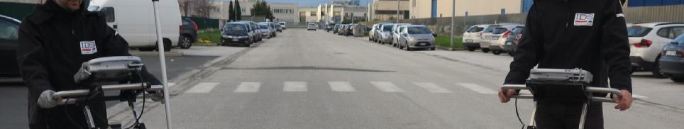
9 Competitive advantages Designedaroundyou Alarge, comfortable handle to make pushing an pulling easier,large wheels for better control and a balanced weight distribution to offer the minimum resistance Robustness Engineered and built to withstand the harshest field conditions, the Opera Duo is suitablefor heavy use inevery type of terrain. Easytouse Opera Duo uses an intuitive interface. Just click the start button to receive the best performance in every soil condition. There is no longer need to perform calibrationor adjustanyother manualsettings. Resultdeliveredonsite IDS s proprietary solution tracks the position of the radar and marks targets automatically. All the acquired data can be exported to CAD and report can be produced directlyon site. all rightsreserved 9
10 Hardware all rights reserved 10


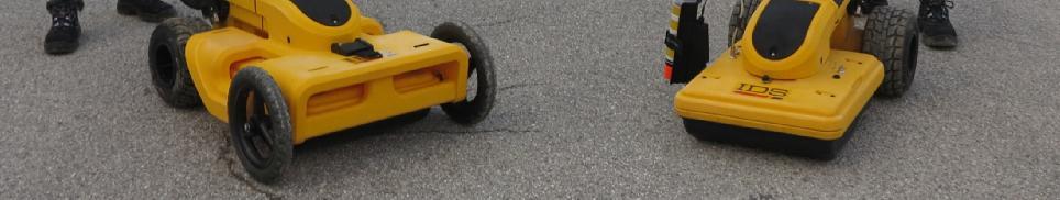
11 2 version available Opera Duo 2wheels 4 wheels all rights reserved 11


12 HW Features Opera Duo Collapsible handle Adjustable handle gives you the perfect grip Pivoting head Dual Frequency antenna 250 & 700 MHz Large wheels gives stability and let the system do not sink all rights reserved 12


13 Hardware features All the parts are integrated in the main body of the products including a dual frequency MHz antenna, a 400 KHz control unit, a battery and two encoders. battery Encoders Dual frequency antenna and control unit all rights reserved 13

14 Pivoting head The head of the Opera Duo can rotate along a longitudinal axis in order to let the antenna be always in contact with the ground in any soil condition. all rights reserved 14
15 Spray marker kit: Remote controlled spray paint marker kit to mark pipes and targets with the minimum effort. A button in the interface regulate the spray. The kit can be mount in 10 seconds. Accessories all rights reserved 15


16 GPS mounting kit: Accessories Aluminum kit to hold a GPS pole. Connection with the PC is available through Bluetooth or Serial ports. all rights reserved 16
17 Acquisition Software Opera Duo Ouverture all rights reserved 17
18 Opera Duo Ouverture SW Features Smart graphic layout optimized for touchscreens Real time estimation of propagation velocity Advanced troubleshooting Advanced Positioning management Digital map exportation Report done on site all rights reserved 18

19 Map Panel Map importation and GPS for positioningmanagement The user can import map in several format, or if connected with the internet, can download in real time the mapofthe area. If GPS is used the navigation interface will show the current position of the radar, the path trajectoryandthetargetsinserted. Google map importation through internet all rights reserved 19


20 Opera Duo Map Panel with GPS Radar path HD aerial map and GPS all rights reserved 20

21 New project acquisition Few seconds are necessary to acquire data with New Project modality. A map will help the user geo-locating the acquisition. MAP Radargram troubleshooting all rights reserved 21


22 New assisted Project acquisition A guided tool will help the user to design and collect data along a grid. Professional survey made easy with the assisted modality! all rights reserved 22

23 Guided grid acquisition all rights reserved 23

24 Opera Duo Ouverture SW report output Every project can be exported as a report. The report include major information including an overall map of the area, the targets detected with their coordinates, a general description of GPR etc. all rights reserved 24
25 SW CAD output Opera Duo Export to IDSGeomap. The IDS tool to add all the targets detected in a CAD file. all rights reserved 25


 via internet. 4.")
26 GPS requirements The Opera Duo system can be used with a GPS to position the scans in real time withoutthe need of doing a grid. The requirement of such GPS are: 1. Dual frequency (L1+L2) 2. Positioning update greater than 5 Hz 3. RTK: connection to a base station via radio link (UHF or GSM) or connection to a Continuously Operating Reference Station (CORS) via internet. 4. NMEA output. 5. Serial cable (RS232) is required PPG/AAAA/nnn all rights reserved 26

27 Video PPG/AAAA/nnn all rights reserved 27
Opera Duo. Opera Duo. GeoRadar Division. a first class underground survey
 a first class underground survey Opera Duo Competitive advantages Designed around you A large, comfortable handle to make pushing an pulling easier, large wheels for better control and a balanced weight
GeoRadar Division A HISTORY OF PROVIDING HIGH TECHNOLOGY. IDS s Pisa Headquarters
 A HISTORY OF PROVIDING HIGH TECHNOLOGY IDS s Pisa Headquarters Subsidiary and office across four continents IDS Tech (Ottawa) IDS North America (Montréal) IDS UK (Fareham) Sistemi Dinamici A joint venture
Strategic City Wide Mapping of Underground Assets using Ground Penetrating Radar. Mark Bell
 Strategic City Wide Mapping of Underground Assets using Ground Penetrating Radar Mark Bell XXV International Federation of Surveyors Congress, Kuala Lumpur, Malaysia, 16 21 June 2014 TOPICS GPR background
Noggin Competitive Analysis. Copyright 2016, Sensors & Software Copyright 2015, Sensors & Software
 Noggin Competitive Analysis Copyright 2015, Sensors & Software Competitive Analysis why do it? Understand the market place & build our product knowledge Learn how we compare Help identify our unique selling
GeoRadar Division. GPR for Archeology and Cultural Heritage. GeoRadar Division. GPR Configuration for Archeology and Cultural Heritage Application
 GeoRadar Division GPR Configuration for Archeology and Cultural Heritage Application We believe that the Archaeological patrimony and the Cultural Heritage are one of the most important aspect of this
Dynatel. 2273M Cable/Pipe and Fault Locators 2273M-iD Cable/Pipe/Fault and Marker Locators with id Read/Write
 3 Dynatel 2273M Cable/Pipe and Fault Locators 2273M-iD Cable/Pipe/Fault and Marker Locators with id Read/Write Designed to be more accurate, faster and more integrated than any other locator on the market,
HGD HURRICANE 2010 / 2011
 HGD HURRICANE 2010 / 2011 The Global Surprise For the Treasures Hunters, Prospecting Amateurs, for all Researchers for Gold and Underground Metals Introduction: The Modern scientific Innovation, Exclusive
Monitoring with low-cost GNSS receivers
 Monitoring with low-cost GNSS receivers GNSS monitoring with low-cost receivers 1 Why GNSS? Your advantages! free of charge and available worldwide No line of sight connection is necessary to the measuring
Basic Functions. The program is able to remotely: - manage all the system parameters of the PPM box. - execute the sensor tuning process
 PPM Utility Program Our PPM system has originally been designed with a basic human-interface made of an integrated LCD and keypad but it can now be remotely controlled from a Windows-based PC through any
Leica GRX1200 Series High Performance GNSS Reference Receivers
 Leica GRX1200 Series High Performance GNSS Reference Receivers Leica GRX1200 Series For permanent reference stations The Leica GRX1200 Series, part of Leica s new System 1200, is designed specifically
GeoMax GNSS Zenith10 & Zenith20 Series
 GeoMax GNSS Zenith10 & Zenith20 Series GeoMax About Us At GeoMax we provide a com- group with strong market At GeoMax, we concentrate on prehensive portfolio of inte- positions within measurement providing
RD1000 Ground Probing Radar
 RD1000 Ground Probing Radar CONTENTS Product Introduction Product Features Competitor Analysis Customers Models, Pricing & Availability Promotional Material Practical Demonstration What to do now Summary
DOCUMENT OBSOLETE. Dynatel. 2273M Cable/Pipe and Fault Locators 2273M-iD Cable/Pipe/Fault and Marker Locators with id Read/Write
 3 Dynatel 2273M Cable/Pipe and Fault Locators 2273M-iD Cable/Pipe/Fault and Marker Locators with id Read/Write New-to-the-world technology for locating underground utilities without any doubt. The 3M Dynatel
Specifications for 3M Dynatel 2273M/M-iD Cable/Pipe and Fault Locators
 Specifications for 3M Dynatel 2273M/M-iD Cable/Pipe and Fault Locators PHYSICAL SPECIFICATIONS SIZE WEIGHT (H X W X D) IN. (CM) (INCLUDING BATTERIES) Transmitter 6.75 x 11.25 x 7.75 (17.2 x 28.6 x 19.7)
Easy Locator HDR. Terraplus Inc. 52 West Beaver Cr. Rd. #12, Richmond Hill, ON. Canada L4B 1L9. Utility Locating System
 Utility Locating System Easy Locator HDR Terraplus is pleased to introduce the Easy Locator HDR (High Dynamic Range). The Easy Locator HDR is faster, easier to use, more powerful, delivers cleaner data
Dynatel Cable/Pipe and Fault Locator 2273M Cable/Pipe, Fault and Marker Locator 2273M-iD
 Dynatel Cable/Pipe and Fault Locator 2273M Cable/Pipe, Fault and Marker Locator 2273M-iD GPS Interface Allows Real-Time Mapping Innovative technology for locating underground utilities without any doubt
Indian Institute of Technology Kanpur Department of Civil Engineering
 Indian Institute of Technology Kanpur Department of Civil Engineering Inquiry No- CE/JNM/2013-14/R-10 30 December, 2013 Subject: Quotation for supply of Integrated System/Smart System Reflectorless Robotic
AgGPS RTK 450 MHz Mobile Base Station and Rover Unit: Setting Up
 6 August 2007 AgGPS RTK 450 MHz Mobile Base Station and Rover Unit: Setting Up This Support Note describes how to set up a Trimble AgGPS RTK 450 mobile base station and rover radio. Instructions apply
CHC i80 GNSS Receiver QuickTour with LandStar7. (PDA Network Mode)
") CHC i80 GNSS Receiver QuickTour with LandStar7 (PDA Network Mode) 1.Prerequisites Hardware: CHC i80 rover, Controller Kit, SIM card,lithium Battery, pole Software: LandStar7 2.Steps to set i80 working
CHC i80 GNSS Receiver QuickTour with LandStar7 (PDA Network Mode) 1.Prerequisites Hardware: CHC i80 rover, Controller Kit, SIM card,lithium Battery, pole Software: LandStar7 2.Steps to set i80 working
Using georadar systems for mapping underground utility networks
 Available online at www.sciencedirect.com ScienceDirect Procedia Engineering 209 (2017) 216 223 Urban Subsurface Planning and Management Week, SUB-URBAN 2017, 13-16 March 2017, Bucharest, Romania Using
----STAR S86 GPS Receiver. User Guide. SOUTH CO., Ltd.
 ----STAR S86 GPS Receiver User Guide SOUTH CO., Ltd. www.southsurveying.com Sales@SOUTHsurveying.com 2 CONTENTS Chapter 1 Introduction... 1 STAR S86 GPS - System Summary... 1 Technical Specification...
Obsolete Document. Dynatel
 3 Dynatel 2273ME Cable/Pipe and Fault Locators 2273ME-iD Cable/Pipe/Fault and Marker Locators with id Read/Write 2250ME Cable/Pipe Locators 2250ME-iD Cable/Pipe and Marker Locators with id Read/Write New-to-the-world
use, more powerful, delivers cleaner data with more detail and up to 20% better penetration depth than comparable systems.
 Utility Locating System Easy Locator HDR Pro Terraplus is pleased to introduce the Easy Locator HDR (High Dynamic Range) Pro. The Easy Locator HDR Pro is faster, easier to use, more powerful, delivers
The on board surveyor
 The on board surveyor A PPK solution for drone-mapping Introduction DROBIT is a high precision positioning system created for drone-based photogrammetry. Its working principle is differential correction
DATACAR ADVANCED MULTILANE TRAFFIC MONITORING SYSTEM
 DATACAR Doc 9723 0030 ADVANCED MULTILANE TRAFFIC MONITORING SYSTEM Suitable both for permanent and temporary installations Non-Intrusive System Accurate detection, speed, counting and classifying traffic
Advanced Utility Locating Technologies (R01B)
") Advanced Utility Locating Technologies (R01B) Jacob Sheehan Senior Geophysicist Olson Engineering Phil Sirles Principal Geophysicist Olson Engineering Introduction: Utility Bundle Overview SHRP2 Strategic
Advanced Utility Locating Technologies (R01B) Jacob Sheehan Senior Geophysicist Olson Engineering Phil Sirles Principal Geophysicist Olson Engineering Introduction: Utility Bundle Overview SHRP2 Strategic
Leica Spider Infrastructure HW Solutions Introducing: Leica GR30 & GR50
 Leica Spider Infrastructure HW Solutions Introducing: Leica GR30 & GR50 Reliable solutions for today and tomorrow Leica Spider Integrated Solutions Introducing: Leica GR30 & GR50 Outline Introducing Leica
TRACKING. ABOVE GROUND MARKER Pg RECEIVERS Pg TRANSMITTERS Pg. 8-3 to 8-5. GEOPHONE Pg DELRIN CANS Pg RENTALS Pg.
 RECEIVERS Pg. 8-2 ABOVE GROUND MARKER Pg. 8-7 TRANSMITTERS Pg. 8-3 to 8-5 GEOPHONE Pg. 8-8 DELRIN CANS Pg. 8-6 RENTALS Pg. 8-9 8-1 8-2 TRACKING RECEIVERS TRAXALL 500 & 501 The TRAXALL 500 and TRAXALL 501
Quick Start. Precis-BX305. Precise GNSS RTK Board.
 Quick Start Precis-BX305 Precise GNSS RTK Board www.tersus-gnss.com December, 2016 Quick Start Guide of Precis-BX305 This quick start guide provides the basic information needed to set up and use Precis-BX305
GPR SURVEY METHOD. Ground probing radar
 The ground penetrating radar (GPR - Ground Probing Radar) is a geophysical method used to investigate the near surface underground. Thanks to its high degree of resolution, the GPR is the most effective
THE BEST GPR DATA QUALITY AT THE BEST PRICE! GROUND PENETRATING RADAR ZOND-12e G R O U N D P E N E T R A T I N G R A D A R S
 GROUND PENETRATING RADAR ZOND-12e General Purpose Pulse GPR ZOND-12e SINGLE CHANNEL OR ADVANCED CONTROL UNITS ZOND 12e GPR is a portable digital Ground Penetrating Radar carried by a single operator. The
S u b s i t e L o c at o r s
 S u b s i t e L o c at o r s > 950R/T > 970T > 910R > EML System > AF2/ft14 > 2150GR S U B S I T E 9 5 0 R / t a n d 9 7 0 T P i p e a n d c a b l e l o c at o r s y s t e m Location, location, location.
Leica GRX1200+ Series High Performance GNSS Reference Receivers
 Leica GRX1200+ Series High Performance GNSS Reference Receivers Leica GRX1200+ Series For permanent reference stations The Leica GRX1200+ Series, part of Leica's future proof System 1200, is designed specifically
SUBSURFACE INSTRUMENTS, INC. AML PRO & AML+ PRODUCT GUIDE
 SUBSURFACE INSTRUMENTS, INC. AML PRO & AML+ PRODUCT GUIDE Advanced Underground PVC Pipe Detection Patented Technology Advanced PVC & PE Pipe Detection FCC, IC & EU/CE Approved www.ssilocators.com INTRODUCING
VBRC 5. Radio Communicator. Installer Manual
 VBRC 5 Radio Communicator Installer Manual 10 / 10 / 2013 CONTENT 1. INTRODUCTION...3 2. SYSTEM STRUCTURE...3 3. SYSTEM PROGRAMMING WITH PC SOFTWARE...5 4. TROUBLESHOOTING...6 5. FIRMWARE UPGRADE...7 6.
GNSS Antenna. David GNSS Receiver. WiFi. 12V DC Ntrip Modem. Ethernet SIM 2/3/4G. Tersus GeoBee. Cost-effective Solution for Ntrip Corrections
 GNSS Antenna SIM 2/3/ Cost-effective Solution for Corrections Cost-effective Solution for Corrections The is a dedicated and cost-effec ve solu on to transmit or receive corre ons. With Tersus Caster Service,
PIPELINE DEFECT MAPPER
 PIPELINE DEFECT MAPPER Receiver Colour Display C.A.T. Survey Graph ACVG Survey Graph GIS View General: The Pipeline Defect Mapper Kit designed and developed in such a way; to precisely locate and assist
Setting up i80 CHC receiver in RTK mode using TcpGPS
 Sumatra, 9 E-29190 Málaga (Spain) www.aplitop.com Phone: +34 952439771 Fax: +34 952431371 Technical Note (tcpgps_en_v41_002_setting_up_chc_i80_in_rtk_mode) Setting up i80 CHC receiver in RTK mode using
Frequency selective monitoring and logging of environmental electromagnetic fields
 FREQUENCY SELECTIVE EMF AREA MONITOR AMS-8060 Frequency selective monitoring and logging of environmental electromagnetic fields Up to 20 fully programmable frequency bands Real built-in spectrum analyser
COBRA CBD UNPARALLELED QUALITY GPR DATA WITHOUT BLIND SPOTS
 COBRA CBD WIRELESS GPR Introducing the smart CBD ANTENNA Triple frequency 200/400/800 MHz Outstanding 50-1400 MHz bandwidth Replaces several conventional antennas UNPARALLELED QUALITY GPR DATA WITHOUT
JOINT STOCK COMPANY. MULTICHANNEL RECEIVER RI-4010M (version RM ) User guide
 User guide") JOINT STOCK COMPANY MULTICHANNEL RECEIVER RI-4010M (version RM1-60619) User guide Safety requirements Before using the multichannel receiver RI-4010M read this user guide and follows safety requirements!
JOINT STOCK COMPANY MULTICHANNEL RECEIVER RI-4010M (version RM1-60619) User guide Safety requirements Before using the multichannel receiver RI-4010M read this user guide and follows safety requirements!
QLD/NT NSW WA
 vlocpro2 vlocpro2 features enhance productive location Rugged ABS & carbon fiber construction IP54 rating for all weather use Color display High speed dual core processor Multiple location modes with compass
EVO4 Data Logger USER GUIDE
 EVO4 Data Logger USER GUIDE AiM Srl. Via Cavalcanti, 8 20063 Cernusco S/N (MI) Italia Tel. (+39) 02.9290571 Made in Italy www.aim-sportline.com EVO4 Data Logger 04 INTRODUCTION 08 GETTING STARTED 12 GENERAL
MSP25. Mobile Sensor Platform
 DATA SHEET Issue 5 May 2017 MSP25 MSP25 Features 0.75m wheel base Square Array Multiplexed alpha, beta, gamma measurements For use with Advanced RM85 Resistance Meter and Expansion Port Interface Box 1
GNSS Receivers, Sensors, Desktop Solutions
 GNSS Receivers, Sensors, Desktop Solutions keep it simple high performance: the best GNSS tracking in field ready, reliable packages coupled with the best field and desktop software tools support and service
UTILITY LOCATING EQUIPMENT
 RIDGID SEEKTECH LOCATING RECEIVERS RIDGID locating receivers feature an easy-to-use visual mapping display that allows you to locate utility lines and sondes/beacons with confidence. Use with a SeeSnake
STANDARD OPERATING PROCEDURES SOP:: 2057 PAGE: 1 of 6 REV: 0.0 DATE: 07/11/03
 PAGE: 1 of 6 1.0 SCOPE AND APPLICATION 2.0 METHOD SUMMARY CONTENTS 3.0 SAMPLE PRESERVATION, CONTAINERS, HANDLING, AND STORAGE 4.0 INTERFERENCES AND POTENTIAL PROBLEMS 5.0 EQUIPMENT/APPARATUS 6.0 REAGENTS
1. Report No. FHWA/TX-05/ Title and Subtitle PILOT IMPLEMENTATION OF CONCRETE PAVEMENT THICKNESS GPR
 1. Report No. FHWA/TX-05/5-4414-01-3 4. Title and Subtitle PILOT IMPLEMENTATION OF CONCRETE PAVEMENT THICKNESS GPR Technical Report Documentation Page 2. Government Accession No. 3. Recipient s Catalog
RELEASE NOTES. Trimble. SPS Series Receivers. Introduction. New features and changes
 RELEASE NOTES Trimble SPS Series Receivers Introduction New features and changes Version 4.42 Revision A June 2011 F Corporate office Trimble Navigation Limited Engineering and Construction group 5475
K Series GNSS Receiver Getting Started
 K Series GNSS Receiver Getting Started K Series GNSS Receiver Getting Started Hi-Target Surveying Instrument Co., Ltd All Rights Reserved K Series GNSS Receiver Getting Started Content 1. Introduction
VisorTrac A Tracking System for Mining
 VisorTrac A Tracking System for Mining Marco North America, Inc. SYSTEM APPLICATION The VISORTRAC system was developed to allow tracking of mining personnel as well as mining vehicles. The VISORTRAC system
Inertial Sensors. Ellipse Series MINIATURE HIGH PERFORMANCE. Navigation, Motion & Heave Sensing IMU AHRS MRU INS VG
 Ellipse Series MINIATURE HIGH PERFORMANCE Inertial Sensors IMU AHRS MRU INS VG ITAR Free 0.2 RMS Navigation, Motion & Heave Sensing ELLIPSE SERIES sets up new standard for miniature and cost-effective
Inertial Systems. Ekinox Series TACTICAL GRADE MEMS. Motion Sensing & Navigation IMU AHRS MRU INS VG
 Ekinox Series TACTICAL GRADE MEMS Inertial Systems IMU AHRS MRU INS VG ITAR Free 0.05 RMS Motion Sensing & Navigation AEROSPACE GROUND MARINE EKINOX SERIES R&D specialists usually compromise between high
Medidores de vibración salida RS232 Datalogger VT-8204 LUTRON manual ingles
 English usermanual VT-8204 Vibration Tachometer Your purchase of this VIBRATION TACHOMETER marks a step forward for you into the field of precision measurement. Although this VIBRATION TACHOMETER is a
CARA Flea Market. System Fusion Digital Communication Solutions
 CARA Flea Market System Fusion Digital Communication Solutions Chris Wilson N0CSW National Sales Manager Yaesu North America New Products DR 1X Repeater Introduction Introduction to System Fusion Comparison
Using Malå GPR systems with GPS equipment
 Using Malå GPR systems with GPS equipment Description of problem In many situations it is convenient to use a GPS to keep track of the position in terms of x- and y-coordinates for all measured GPR profiles.
World s fastest robot for stake out
 TinySurveyor World s fastest robot for stake out GNSS options The TinySurveyor can integrate with your existing GNSS equipment. The robot integrates with a total station for height measurements as well
Guide to GNSS Base stations
 Guide to GNSS Base stations Outline Introduction Example of a base station (TUMSAT) Preparation for setting up a base station Procedure for setting up a base station Examples at two other universities
Continuously monitors and stores the levels of Electromagnetic fields Up to four simultaneous bands: GSM 900 / 1800 MHz / UMTS / Broadband 100 khz 3
 Continuously monitors and stores the levels of Electromagnetic fields Up to four simultaneous bands: GSM 900 / 1800 MHz / UMTS / Broadband 100 khz 3 GHz Magnetic fields monitoring from 10 Hz to 5 khz Automatic
GPS-G5 User s Manual
 GPS-G5 User s Manual Contents Using the GPS... 1 Description...1 Electrical Connections...2 Mounting...3 GPS Configuration...3 GPS Operation...3 Logging Device Configuration...4 Data Analysis...5 Specifications...
GPR SYSTEM USER GUIDE AND TROUBLESHOOTING GUIDE
 GPR SYSTEM USER GUIDE AND TROUBLESHOOTING GUIDE Implementation Report 5-4414-01-1 Project Number 5-4414-01 Subsurface Sensing Lab Electrical and Computer Engineering University of Houston 4800 Calhoun
E600 Series II Portable, Tactical Weather Radar System
 E600 Series II Portable, Tactical Weather Radar System E600 Tactical Weather Radar System Used as a tactical unit by the U.S. Military, the E600 Series II is the most portable weather radar system on
TX CONTROLLER Model EM-IP Quick Start Guide
 TX CONTROLLER Model EM-IP Quick Start Guide 860 boul. de la Chaudière, suite 200 Québec (Qc), Canada, G1X 4B7 Tel.: +1 (418) 877-4249 Fax: +1 (418) 877-4054 E-Mail: gdd@gdd.ca Web site: www.gdd.ca Visit
GROUND PENETRATING RADAR (GEORADAR) INSPECTION
 INSPECTION") - CIVIL ENGENEERING - GEOLOGY AND ENVIRONMENT - GROUND PENETRATING RADAR - LOSSES DETECTING RADAR SYSTEM - ARCHEOLOGY & CULTURAL HERITAGE - CARGO INSPECTION - LOSS CONTROL - CHEMICAL ANALYSIS - INDUSTRIAL
- CIVIL ENGENEERING - GEOLOGY AND ENVIRONMENT - GROUND PENETRATING RADAR - LOSSES DETECTING RADAR SYSTEM - ARCHEOLOGY & CULTURAL HERITAGE - CARGO INSPECTION - LOSS CONTROL - CHEMICAL ANALYSIS - INDUSTRIAL
SPEEDBOX Technical Datasheet
 SPEEDBOX Technical Datasheet Race Technology Limited, 2008 Version 1.1 1. Introduction... 3 1.1. Product Overview... 3 1.2. Applications... 3 1.3. Standard Features... 3 2. Port / Connector details...
Featherweight GPS Tracker User s Manual June 16, 2017
 Featherweight GPS Tracker User s Manual June 16, 2017 Hardware Configuration and Installation The dimensions for the board are provided below, in inches. Note that with the antenna installed, the total
New Directions in Buried UXO Location and Classification
 New Directions in Buried UXO Location and Classification Thomas Bell Principal Investigator, ESTCP Project MR-200909 Man-Portable EMI Array for UXO Detection and Discrimination 1 Introduction Why this
Getting Started with TrangoLink
 Getting Started with TrangoLink Overview: TrangoLink allows you to configure and monitor your EAGLE PLUS, FALCON, or PTZ-900 transmitters and receivers. On the EAGLE PLUS and FALCON transmitters, you can
BMW E6x/E9x Android Touch Screen Radio Installation Instructions
 BMW E6x/E9x Android Touch Screen Radio Installation Instructions Enjoy your new Android Radio from Bremmen Parts, we appreciate your business. Vibrant Touch Display This radio features a responsive 8.8
LOCATION & IDENTIFICATION OF NETWORKS
 LOCATION & IDENTIFICATION OF NETWORKS ELIOT INNOVATIVE SOLUTIONS 33, route de Grenoble 38590 Saint-Étienne-de-Saint-Geoirs France T. +33 (0)4 76 93 43 33 F. +33 (0)4 76 93 43 30 www.eliot-solutions.com
1 Introduction integrated 3D sonar system for underwater inspection applications
 1 Introduction The Underwater Inspection System (UIS TM ) is an integrated 3D sonar system for underwater inspection applications, specifically port and harbor construction, maintenance, port expansion,
L O C A T O R G P R. Introducing the. Radarteam. Ground Probing Radar/Antenna system with Rugged PC and Cart ü
 Introducing the L O C A T O R G P R Ground Probing Radar/Antenna system with Rugged PC and Cart ü Fully integrated system. Multi Frequency operation: 100-900 MHz ü Air/Ground Coupled operation. Multiple
Above All. The most sophisticated unit for tracking containers in real time for security and management.
 * The most sophisticated unit for tracking containers in real time for security and management. The French comedian Pierre Dac once said, To see into the distance, you simply need to get closer. That applies
GPS Pathfinder ProXH and ProXT Customer FAQs
 7 December 2009 GPS Pathfinder ProXH and ProXT Customer FAQs What is the GPS Pathfinder ProXH receiver? The GPS Pathfinder ProXH receiver is a fully integrated receiver, antenna and battery unit with Trimble
SA-320 Installation Guide SA-320. Installation Guide. Date: Nov., 2004 Version: 1.0. All Rights Reserved
 SA-320 Installation Guide Date: Nov., 2004 Version: 1.0 All Rights Reserved Page 1 TABLE OF CONTENTS 1. Product Overview......3 1.1 Main...3 1.2 Applications.....3 1.3 Package Content.....3 2. Installation.4
SONARMITE v4.0 MTX sweep version - PORTABLE BLUETOOTH ECHO SOUNDER
 SONARMITE v4.0 MTX sweep version - PORTABLE BLUETOOTH ECHO SOUNDER Introduction The SonarMite Echo Sounder was the result of nearly two years research and development to further extend the boundaries of
CONDOR C1722 GPS RECEIVER MODULE technical notes
 CONDOR C1722 GPS RECEIVER MODULE TECHNICAL HIGHLIGHTS Receiver: GPS L1 frequency (1575.42 MHz), C/A code, 22-channel continuous tracking NMEA output and input: serial port, USB port On-board low noise
AT-5000 Professional Underground Cable / Pipe Locator System
 AT-5000 Professional Underground Cable / Pipe Locator System Buried Utilities represent a major challenge to electricians who need to trace and trouble shoot such systems. They also represent a hazard
Radio Mobile. Software for Wireless Systems Planning
 Latin American Networking School (EsLaRed) Universidad de Los Andes Merida Venezuela Javier Triviño and E.Pietrosemoli Radio Mobile Software for Wireless Systems Planning About Radio Mobile It is a tool
Touchscreens, tablets and digitizers. RNDr. Róbert Bohdal, PhD.
 Touchscreens, tablets and digitizers RNDr. Róbert Bohdal, PhD. 1 Touchscreen technology 1965 Johnson created device with wires, sensitive to the touch of a finger, on the face of a CRT 1971 Hurst made
Utility Survey User Guide
 Utility Survey User Guide Table of Contents ABOUT THIS GUIDE...2 LINE MODE...2 SETUP INSTRUCTIONS... 3 Step 1: Construct the spar apparatus... 3 Step 2: Set up the data collecting device... 3 Step 3: Set
Inertial Sensors. Ellipse 2 Series MINIATURE HIGH PERFORMANCE. Navigation, Motion & Heave Sensing IMU AHRS MRU INS VG
 Ellipse 2 Series MINIATURE HIGH PERFORMANCE Inertial Sensors IMU AHRS MRU INS VG ITAR Free 0.1 RMS Navigation, Motion & Heave Sensing ELLIPSE SERIES sets up new standard for miniature and cost-effective
WSPR VCXO Controller
 WSPR VCXO Controller A WSPR controller using pulse width modulation (PWM) to derive narrow-band 4-FSK modulation from a voltage controlled crystal oscillator (VCXO). Features: - Internal timing or NMEA
Inertial Sensors. Ellipse 2 Series MINIATURE HIGH PERFORMANCE. Navigation, Motion & Heave Sensing IMU AHRS MRU INS VG
 Ellipse 2 Series MINIATURE HIGH PERFORMANCE Inertial Sensors IMU AHRS MRU INS VG ITAR Free 0.1 RMS Navigation, Motion & Heave Sensing ELLIPSE SERIES sets up new standard for miniature and cost-effective
USER MANUAL FIELDBEE AND RTK BEE STATION FULL VERSION. WE PROVIDE ONLINE SUPPORT: VERSION 1.0.
 USER MANUAL FULL VERSION VERSION 1.0. FIELDBEE AND RTK BEE STATION WE PROVIDE ONLINE SUPPORT: support@efarmer.mobi info@efarmer.mobi CONTENTS TABLE OF CONTENTS INTRODUCTION... 3 3 WAYS OF USING FIELDBEE...
Wireless Sensor Networks for Aerospace Applications
 SAE 2017 Aerospace Standards Summit th 25-26 April 2017, Cologne, Germany Wireless Sensor Networks for Aerospace Applications Dr. Bahareh Zaghari University of Southampton, UK June 9, 2017 In 1961, the
DATAMAR 2000 MICROWAVE (26 GHz) RADAR TIDE GAUGE
 RADAR TIDE GAUGE") DATAMAR 2000 MICROWAVE (26 GHz) RADAR TIDE GAUGE BATTERY POWERED COMPACT AND STAND ALONE TIDE GAUGE WITH MICROWAVE RADAR SENSOR (26 GHz) PROVIDING EXTREMELY HIGH PRECISION AND STABILITY Level measurements
DATAMAR 2000 MICROWAVE (26 GHz) RADAR TIDE GAUGE BATTERY POWERED COMPACT AND STAND ALONE TIDE GAUGE WITH MICROWAVE RADAR SENSOR (26 GHz) PROVIDING EXTREMELY HIGH PRECISION AND STABILITY Level measurements
ECE 477 Digital Systems Senior Design Project Rev 8/09. Homework 5: Theory of Operation and Hardware Design Narrative
 ECE 477 Digital Systems Senior Design Project Rev 8/09 Homework 5: Theory of Operation and Hardware Design Narrative Team Code Name: _ATV Group No. 3 Team Member Completing This Homework: Sebastian Hening
SETTOPSURVEY, S.L. Bofarull 14, Barcelona (Spain) Phone: (+34) Fax: (+34)
 Phone: (+34) Fax: (+34)") USER MANUAL v.5 Settop Repeater 2 Index SETTOP Repeater... 3 Control Software... 5 SETTINGS: Configuration... 7 RADIO... 8 INTERNET SETUP: Configuration of the internet protocols... 10 CELLULAR MODEM:
USER MANUAL v.5 Settop Repeater 2 Index SETTOP Repeater... 3 Control Software... 5 SETTINGS: Configuration... 7 RADIO... 8 INTERNET SETUP: Configuration of the internet protocols... 10 CELLULAR MODEM:
David GNSS Receiver Base & Rover Kits
 A ffordable Centimeter Precision for Everyone Base & Rover Kits METER Tersus The Tersus is a cost-efficient, palm-sized GNSS receiver designed for UAVs, AGVs, and surveying applica ons. Using an external
Inertial Sensors. Ellipse Series MINIATURE HIGH PERFORMANCE. Navigation, Motion & Heave Sensing IMU AHRS MRU INS VG
 Ellipse Series MINIATURE HIGH PERFORMANCE Inertial Sensors IMU AHRS MRU INS VG ITAR Free 0.1 RMS Navigation, Motion & Heave Sensing ELLIPSE SERIES sets up new standard for miniature and cost-effective
CONDOR C1919 GPS RECEIVER MODULE technical notes GENERAL OVERVIEW
 CONDOR C1919 GPS RECEIVER MODULE TECHNICAL HIGHLIGHTS Receiver: GPS L1 frequency (17. MHz), C/A code, -channel continuous tracking NMEA output and input: serial port On-board low noise amplifier GENERAL
For Experimenters and Educators
 For Experimenters and Educators ARobot (pronounced "A robot") is a computer controlled mobile robot designed for Experimenters and Educators. Ages 14 and up (younger with help) can enjoy unlimited experimentation
Easy Locator. Operator s Manual. Version
 Easy Locator Operator s Manual Version 2.6 19-001011 Table of Contents 1 Introduction 3 1.1 Unpacking and Inspection 4 1.2 Repacking and Shipping 4 1.3 Important information regarding the use of this GPR
GETTING STARTED GUIDE X91GNSS
 GETTING STARTED GUIDE X91GNSS Copyright Copyright 2009-2011 CHC. 2010-Shanghai HuaCe Navigation Technology Ltd. All rights reserved. The CHC are trademark of Shanghai Huace Navigation Technology Limited.
 Wireless Technology Wireless devices transmit information via Electromagnetic waves Early wireless devices Radios often called wireless in old WWII movies Broadcast TV TV remote controls Garage door openers
670 10/26/17 SSD: 07/14/16, 09/16/17 Page 1 of 6
 SSD: 07/14/16, 09/16/17 Page 1 of 6 S P E C I A L P R O V I S I O N Section MISCELLANEOUS INCIDENTALS Item.822 - GNSS Construction Inspection Equipment Description SAMPLE PROJECT 12345 10/30/17 1.1 Work
R5 RIC Quickstart R5 RIC. R5 RIC Quickstart CONTENTS. Saab TransponderTech AB. Appendices. Project designation. Document title
 Appendices 1 (10) Project designation R5 RIC Document title CONTENTS 1 Installation... 2 1.1 Connectors... 2 1.1.1 Power... 2 1.1.2 Video... 2 1.1.3 Sync... 3 1.1.4 RS232/ARP/ACP... 3 1.1.5 Radar data...
GPS-Disciplined-Rubidium Clock AR70A-00
 GPS-Disciplined-Rubidium Clock Miniature GPS-Rubidium Main Features Rubidium clock disciplined to GPS Outputs: 10MHz, 1PPS Inputs: External 1PPS, GPS antenna Time Accuracy: 100ns relative to GPS Frequency
C94-M8P Application Board Setup Guide
 C94-M8P Application Board Setup Guide locate, communicate, accelerate UBX-16009722 R02 C94-M8P Board Connections and Interfaces J1 J10 J2 J3 J1: RS232 UART M8P/Radio J2: USB M8P J3: External battery /