Ground Penetrating Radar (GPR) By Dr. Eng. Zubair Ahmed
|
|
|
- Sybil Wheeler
- 5 years ago
- Views:
Transcription
 By Dr. Eng.")
1 Ground Penetrating Radar (GPR) By Dr. Eng. Zubair Ahmed
2 Acknowledgement Golder Associates, Whitby, Ontario Stantec Consulting, Kitchener, Ontario Infrasense Inc. USA Geophysical Survey Systems Inc. (GSSI), USA Gulf Engineering House, Riyadh
3 Presentation Outline GPR Overview GPR Principles GPR Equipment Data Collection and Processing Technology Evaluation Pavement Applications Q/A
4 GPR - Overview Non-destructive inspection of the Earth and its Infrastructure Commercialized use since early 1970 s Average radiated power is approximately 1% of cell phone transmitted power Safe to use Has many practical applications From 0.1 m to 300 m depths
5 GPR - Overview Pavement layer identification Concrete inspection (locate rebar, tension cables, etc) Utility detection (pipes, tanks, etc) Bridge deck condition assessment Rail-bed condition assessment Geology, mining Archeology Crime Scene Investigations (CSI) and Forensics Military/Espionage
6 GPR - Overview All GPR systems sold in the U.S. after July 15, 2002 must comply with FCC regulations. The radar collection unit is limited to a transmission rate of 100 KHz (U.S. versions only). Using 512 samples per scan, this is about 153 scans per second. Fortunately, for Pavement applications, this is not a problem. With 153 scans per second, 512 samples per scan, you can collect 3 scans/meter at approximately 110 KPH. The antenna must pass an FCC emissions test.


7 GPR. - Principles GPR uses high frequency electromagnetic pulses to image features within the subsurface Direct Coupling Antenna Reflections are generated from material interfaces in the subsurface Each material has different electrical conductivity Ground Coupling Layer Interface Layer Interface Layer Interface
8 GPR - Principles Electrical Conductivity The ability of a material to conduct an electric current Higher conductivities make GPR signal penetration difficult Use published sources or take readings from field Good Conductivity Air, Concrete, Asphalt Medium Conductivity Ice, snow, sand, silt, dry clay Poor Conductivity Wet Clay, Wet Shale, Seawater
9 GPR - Principles GPR sees changes in electrical conduction properties of a material It does not read changes in colour, temperature, or density Best at seeing sharp contrasts Metal targets stop 100% of signal
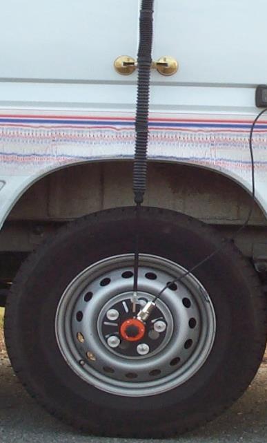
10 GPR - Principles Dielectric Constant Unit-less measure of a material s ability to hold and pass a charge Values range from 1 (air) to 81 (water) Lower the number, higher the velocity Referenced published values Asphalt Concrete values range from 3 to 5 PCC values range from 6 to 11 Cement Treated Base = 2 to 5


11 GPR - Principles We record the two way travel time and the amplitude of the reflection
12 GPR - Principles
13 Travel Time GPR - Principles 1. GPR Transmitter Transmits Electromagnetic Pulse into Ground Tx Rx Distance Asphalt Concrete
14 Travel Time GPR - Principles 2. Electromagnetic Energy Travels Down Into The Ground Tx Rx Distance Asphalt Concrete
15 Travel Time GPR - Principles 3. Reflections From Layer Interfaces are Reflected Back to Surface and Measured by the GPR Receiver Tx Rx Distance Asphalt Concrete
16 Travel Time GPR - Principles 4. GPR Transmitter/Receiver Are Moved and Testing is Repeated Tx Rx Distance Asphalt Concrete
17 Travel Time GPR - Principles 5. Testing is Completed over Entire Area To Be Tested Distance Pavement Surface Base of Asphalt Base of Concrete
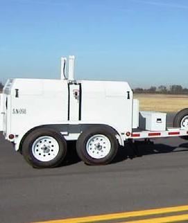
18 GPR - Equipment System includes: GPR data collection system Air launched horn antenna (1 GHz or 2 GHz) or Ground Coupled antenna (200 MHz to 1 GHz) Antenna mounting hardware for vehicle Antenna cable Wheel mounted Distance Measuring Instrument (DMI) Data Processing software Road structure assessment module

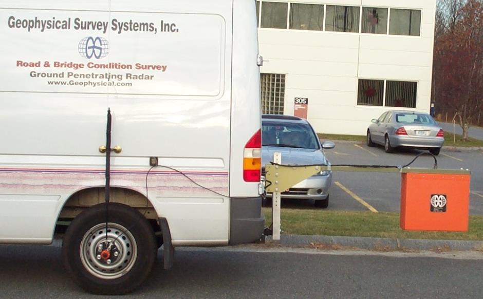
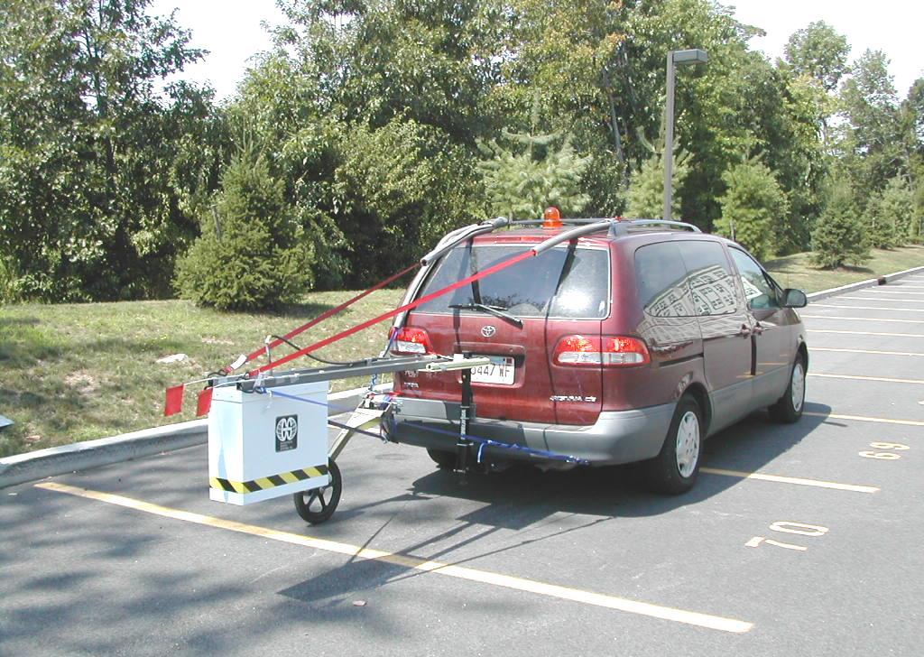
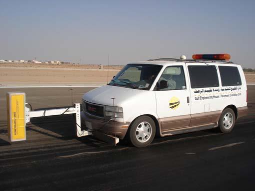
19 Distance Measuring Instrument (DMI) GPR - Equipment Air Launched
 18-20 (46-51 cm) Antenna level")
20 GPR - Equipment Horn Antenna Mounting Adjustable straps Transducer cable fastened to rail 40 (1 meter) (46-51 cm) Antenna level


21 Trimble DGPS Receiver on Roof GPR - Equipment Ground Coupled 1000 MHz Radar System 500 MHz Radar System


22 Display Units to See Results in Real Time GPR - Equipment Real Time Data Acquisition


23 GPR - Data Collection Antenna Calibration An antenna calibration file is collected using a metal plate as a perfect reflector

24 GPR - Data Collection Raw Data


25 GPR - Data Collection Examples of Various Scan Rates Example at 10 Scans/m 5 Scans/m 2.5 1
26 GPR - Data Collection Field Guidelines Record any features that may be located within 2 m of the antenna during data collection. For example, note if any cars pass near the antenna. Do not use Cell phone while collecting GPR data. Interference Should have someone taking notes and writing down key observations Milepost signs Cracks Culverts, pipes Guard rails located near the antenna could also cause problems, especially if the antenna is mounted on the passenger side of the vehicle. The reflection from the rails may erroneously be interpreted as a layer interface


27 GPR - Data Processing Ground Truth Use core data to enter ground truth data

28 Time (ns) Depth (m, v=0.110m/ns) GPR - Processing C:\QEW Niagara GPR\Final Data\L7_1000 Human Interpretation Asphalt Concrete Position (m)

29 GPR - Data Processing Interpretation Software

30 GPR - Data Processing Interpretation Software

31 GPR - Data Processing Result The.LAY file is a generic comma delimited ASCII file that is easily imported into Excel and a variety of other software programs

32 GPR - Visual Image Flexible Pavement Bottom of asphalt layer Bottom of aggregate layer I-676 N at Milepost 0.39
33 GPR - Visual Image Rigid Pavement Bottom of concrete layer Bottom of aggregate layer
34 GPR - Visual Image Composite Pavement Bottom of asphalt layer Bottom of concrete layer Bottom of aggregate layer
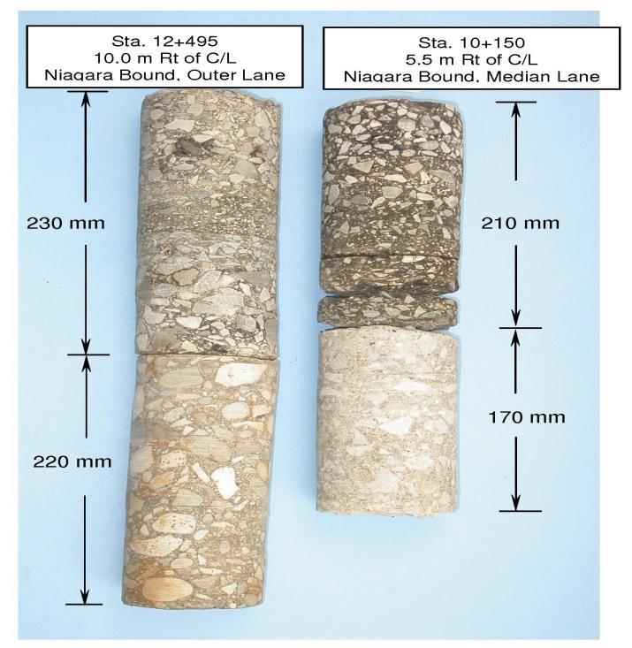
35 GPR Example Used 2 Ground Coupled Systems: 1000 MHz and 500 MHz Data Collected at 0.1 m Increments 2 Passes Per Lane 30 km/h Acquisition Speed Location using Wheel Odometer Tied to Chainage Markers and GPS Total GPR Lane Distance = 125,000 m Total Survey Time = 9 hours 1.5 m 1.5 m

36 Time (ns) Depth (m, v=0.110m/ns) C:\QEW Niagara GPR\Final GPR Data\Edit1\L6_ Example Asphalt Concrete Dowel Pins Asphalt/Concrete Pavement to ~ Position (m) Westbound Median Lane Right Side

37 Time (ns) Depth (m, v=0.11m/ns) GPR - Example C:\QEW Niagara GPR\Raw Data\1000 MHz\Position\LINE1.dt Pavement Surface Asphalt Repair Of Failed Concrete Slab Asphalt Concrete ~ 80 x Vertical Exaggeration! Position (m)


38 GPR Technology Evaluation Direct coupling Ground coupling Metal strips buried at sub-base and sub-grade interfaces

39 GPR Technology Evaluation
40 GPR Technology Evaluation I -195 SPS 5 Section GPR AS-BUILT Section From MP To MP Surface Base Subbase Surface Base Subbase
41 GPR Technology Evaluation Average % Difference in Layer Thickness 75th Percentile % Difference in Layer Thickness Pavement Type AC PCC Aggregate AC PCC Aggregate Flexible Rigid Composite (flexible over rigid)
42 GPR Technology Evaluation 1 GHz Horn Antenna 2 GHz Horn Antenna

43 GPR Technology Evaluation Wearing Course 2 GHz Data Pavement Bottom 1 GHz Data


44 GPR Technology Evaluation 4.7 cm Wearing Course Thickness GPR Calculated Wearing Course Thickness = 4.8 cm
45 Pavement Applications
46 Pavement Conventional Investigation Methods Boreholes Visual Survey FWD Cores
 Pavement Integration of Visual Survey with GPR Possible Full Depth Asphalt Repair Identified and Interpreted Based on GPR and Visual Survey Results 0.")
47 Time (ns) Depth (m, v=0.110m/ns) Pavement Integration of Visual Survey with GPR Possible Full Depth Asphalt Repair Identified and Interpreted Based on GPR and Visual Survey Results 0.0 C:\Unsorted Data\QEW Niagara GPR\Final Data\Edit1\L1_ Position (m) 1.1
48 Pavement Integration of Borehole Data with GPR
49 Accurately Identify Pavement Changes Pavement Integration of FWD Results with GPR
50 Depth of Pavement (in) Normalized Maximum Deflection (mils) Pavement Integration of FWD and Core with GPR 0 Comparison of GPR, Cores, and Deflection Data on I-287 North Legend AC - GPR PCC - GPR Base - GPR AC - Core PCC - Core Base - Core Normalized Deflection Mile Post 2 0

51 Pavement Management System As-Built, Core/Bore, GPR, FWD, and GPS Databases Airport PMS Photo Courtesy Stantec Consulting

52 PMS Inventory Integration
53 PMS Life Cycle Cost Analysis Additional Cost for Overlay Thickness (in) Overdesigned Section Difference Sections (per 2-lane Number Non-GPR GPR (in) Status mile) Overdesign $316, Underdesign Underdesign Underdesign Underdesign Underdesign Underdesign Underdesign Underdesign Underdesign Underdesign Underdesign Underdesign Underdesign Overdesign $105, Overdesign $105,600
54 Assuming three-mile project sections PMS Life Cycle Cost Analysis Additional cost for the three over-designed sections is about $1.6 million per 2-lane mile PWV of the additional cost for an under-designed section is around $85,000 per lane mile Additional cost for the thirteen (13) underdesigned sections is about $ 6.6 million per 2-lane mile In addition, a significant user delay cost is expected for the under-designed sections
55 GPR Conclusions A non-destructive technology Continuous Profiles obtained compared to point information provided by cores, bores and sawcuts Reduces the amount of intrusive work needed, while raising the level of confidence in structural assessments Minimized traffic control costs and disruptions to traffic flow in comparison to intrusive methods Integration of GPR with visual, destructive and non-destructive methods present a complete picture of the pavement condition and help in determining the most appropriate rehabilitation strategy for each section within the project limits
56 GPR Conclusions GPR can be used as a supplementary tool to ground truths for acquisition and development of database for network and project level PMS applications Incorporation of GPR data minimizes the gaps and deficiencies in the PMS database and enhances the PMS through improved and effective M&R and optimization analyses Overall, GPR is a useful tool for pavement engineers, providing them the information they need to make improved and sound engineering decisions
57 Thank You. Questions??
GPR Data Acquisition and Interpretation
 1 GPR Data Acquisition and Interpretation Mezgeen Rasol PhD Candidate Geophysics and Seismic Engineering Polytechnic University of Catalonia mezgeen.rasol@upc.edu BIG-SKY-EARTH Cost Action TD143 Workshop
The use of high frequency transducers, MHz, allowing the resolution to target a few cm thick in the first half meter suspect.
 METHODOLOGY GPR (GROUND PROBING RADAR). In recent years the methodology GPR (Ground Probing Radar) has been applied with increasing success under the NDT thanks to the high speed and resolving power. As
Investigation of Bridge Decks Utilizing Ground Penetrating Radar
 Investigation of Bridge Decks Utilizing Ground Penetrating Radar Steve Cardimona *, Brent Willeford *, John Wenzlick +, Neil Anderson * * The University of Missouri-Rolla, Department of Geology and Geophysics
Advanced Ground Investigation Techniques to Help Limit Risk or Examine Failure. Advanced Subsurface Investigations
 Advanced Ground Investigation Techniques to Help Limit Risk or Examine Failure Overview Introduction What is geophysics? Why use it? Common Methods Seismic Ground Radar Electrical Case Studies Conclusion
Model 4105 Horn Antenna
 Model 4105 Horn Antenna System Settings and User Notes The Difference is the Data 13 Klein Drive, P.O. Box 97 North Salem, NH 03073-0097 Phone: (603) 893-1109 / Fax: (603) 889-3984 www.geophysical.com
GPR SURVEY METHOD. Ground probing radar
 The ground penetrating radar (GPR - Ground Probing Radar) is a geophysical method used to investigate the near surface underground. Thanks to its high degree of resolution, the GPR is the most effective
3D UTILITY MAPPING USING ELECTRONICALLY SCANNED ANTENNA ARRAY. Egil S. Eide and Jens F. Hjelmstad
 D UTILITY MAPPING USING ELECTRONICALLY SCANNED ANTENNA ARRAY Egil S. Eide and Jens F. Hjelmstad Department of Telecommunications Norwegian University of Science and Technology, N-79 Trondheim, Norway eide@tele.ntnu.no
Case Studies and Innovative Uses of GPR for Pavement Engineering Applications
 Case Studies and Innovative Uses of GPR for Pavement Engineering Applications Richard Korczak, MASc., P.Eng., Stantec Consulting Ltd. Amir Abd El Halim, PhD., P.Eng., Stantec Consulting Ltd. Paper prepared
Standard Test Method for Evaluating Asphalt-Covered Concrete Bridge Decks Using Ground Penetrating Radar 1
 Designation: D 6087 08 Standard Test Method for Evaluating Asphalt-Covered Concrete Bridge Decks Using Ground Penetrating Radar 1 This standard is issued under the fixed designation D 6087; the number
Using GPR Technique Assessment for Study the Sub-Grade of Asphalt and Concrete Conditions
 Using GPR Technique Assessment for Study the Sub-Grade of Asphalt and Concrete Conditions Alaa S. Mahdi Remote Sensing Unit, College of Science, University of Baghdad, Baghdad, Iraq Abstract The Ground
Estimaton of Rebar Diameter Using Ground Penetrating Radar
 International Journal of Advances in Scientific Research and Engineering (ijasre) E-ISSN : 2454-8006 Vol.3, Special Issue 1 Aug - 2017 Estimaton of Rebar Diameter Using Ground Penetrating Radar K Ambika
Ground Penetrating Radar Survey of. Interstate 70 Across Missouri
 Ground Penetrating Radar Survey of Interstate 70 Across Missouri Steve Cardimona *, Brent Willeford *, Doyle Webb *, John Wenzlick +, Neil Anderson * * The University of Missouri-Rolla, Department of Geology
Exploration Beyond Expectation. Geo-Carte Radar Technology Pvt. Ltd.
 Exploration Beyond Expectation Geo-Carte Radar Technology Pvt. Ltd. Problem Unknown distribution network of underground pipeline in India 32% Damage of pre-existing underground utilities during laying
Results of GPR survey of AGH University of Science and Technology test site (Cracow neighborhood).
.") Results of GPR survey of AGH University of Science and Technology test site (Cracow neighborhood). October 02, 2017 Two GPR sets were used for the survey. First GPR set: low-frequency GPR Loza-N [1]. Technical
Results of GPR survey of AGH University of Science and Technology test site (Cracow neighborhood). October 02, 2017 Two GPR sets were used for the survey. First GPR set: low-frequency GPR Loza-N [1]. Technical
Diagnostics of Bridge Pavements by Ground Penetrating Radar
 11th European Conference on Non-Destructive Testing (ECNDT 2014), October 6-10, 2014, Prague, Czech Republic Diagnostics of Bridge Pavements by Ground Penetrating Radar Radek MATULA 1, Josef STRYK 1, Karel
THE BEST GPR DATA QUALITY AT THE BEST PRICE! GROUND PENETRATING RADAR ZOND-12e G R O U N D P E N E T R A T I N G R A D A R S
 GROUND PENETRATING RADAR ZOND-12e General Purpose Pulse GPR ZOND-12e SINGLE CHANNEL OR ADVANCED CONTROL UNITS ZOND 12e GPR is a portable digital Ground Penetrating Radar carried by a single operator. The
Advanced Utility Locating Technologies (R01B)
") Advanced Utility Locating Technologies (R01B) Jacob Sheehan Senior Geophysicist Olson Engineering Phil Sirles Principal Geophysicist Olson Engineering Introduction: Utility Bundle Overview SHRP2 Strategic
Advanced Utility Locating Technologies (R01B) Jacob Sheehan Senior Geophysicist Olson Engineering Phil Sirles Principal Geophysicist Olson Engineering Introduction: Utility Bundle Overview SHRP2 Strategic
Archaeo-Geophysical Associates, LLC
 Geophysical Survey at the Parker Cemetery Rockwall, Texas. AGA Report 2010-6 Report Submitted To: Texas Cemetery Restoration 10122 Cherry Tree Dr. Dallas, Texas 75243 May 14, 2010 Chester P. Walker, Ph.D.
Assessment of layer thickness and uniformity in railway embankments with Ground Penetrating Radar
 Assessment of layer thickness and uniformity in railway embankments with Ground Penetrating Radar F.M. Fernandes Department of Civil Engineering, University of Minho, Guimarães, Portugal M. Pereira Geotechnique
Advances in NDE Technology WHATS NEW?
 Advances in NDE Technology WHATS NEW? Glen Simula, Owner GS Infrastructure, Inc. The state of America s deteriorating infrastructure presses us to find solutions to assess, with limited funds and resources.
Tri-band ground penetrating radar for subsurface structural condition assessments and utility mapping
 Tri-band ground penetrating radar for subsurface structural condition assessments and utility mapping D. Huston *1, T. Xia 1, Y. Zhang 1, T. Fan 1, J. Razinger 1, D. Burns 1 1 University of Vermont, Burlington,
1. Report No. FHWA/TX-05/ Title and Subtitle PILOT IMPLEMENTATION OF CONCRETE PAVEMENT THICKNESS GPR
 1. Report No. FHWA/TX-05/5-4414-01-3 4. Title and Subtitle PILOT IMPLEMENTATION OF CONCRETE PAVEMENT THICKNESS GPR Technical Report Documentation Page 2. Government Accession No. 3. Recipient s Catalog
ScienceDirect. A comparison of dielectric constants of various asphalts calculated from time intervals and amplitudes
 Available online at www.sciencedirect.com ScienceDirect Procedia Engineering 111 (2015 ) 660 665 XXIV R-S-P seminar, Theoretical Foundation of Civil Engineering (24RSP) (TFoCE 2015) A comparison of dielectric
SIR, UtilityScan and RADAN are registered trademarks of Geophysical Survey Systems, Inc.
 Copyright 2016-2017 Geophysical Survey Systems, Inc. All rights reserved including the right of reproduction in whole or in part in any form Published by Geophysical Survey Systems, Inc. 40 Simon Street
7. Consider the following common offset gather collected with GPR.
 Questions: GPR 1. Which of the following statements is incorrect when considering skin depth in GPR a. Skin depth is the distance at which the signal amplitude has decreased by a factor of 1/e b. Skin
Ground Penetrating Radar
 REPORT 4A Ground Penetrating Radar Introduction to GPR, and positioning of GPR data Part of R&D project Infrastructure in 3D in cooperation between Innovation Norway, Trafikverket and TerraTec Yta för
L O C A T O R G P R. Introducing the. Radarteam. Ground Probing Radar/Antenna system with Rugged PC and Cart ü
 Introducing the L O C A T O R G P R Ground Probing Radar/Antenna system with Rugged PC and Cart ü Fully integrated system. Multi Frequency operation: 100-900 MHz ü Air/Ground Coupled operation. Multiple
GPR SYSTEM USER GUIDE AND TROUBLESHOOTING GUIDE
 GPR SYSTEM USER GUIDE AND TROUBLESHOOTING GUIDE Implementation Report 5-4414-01-1 Project Number 5-4414-01 Subsurface Sensing Lab Electrical and Computer Engineering University of Houston 4800 Calhoun
GPR Investigation: Post Tension Cable Mapping
 CMD Civil Pty Ltd PO Box 1119 Huntingdale VIC 3166 +61 3 9544 8833 info@cmdcivil.com www.cmdcivil.com Case Study: GPR Investigation: Post Tension Cable Mapping This application note demonstrates an example
Form DOT F (8-72) This form was electrically by Elite Federal Forms Inc. 16. Abstract:
 This form was electrically by Elite Federal Forms Inc. 16. Abstract:") 1. Report No. FHWA/TX-06/0-4820-3 4. Title and Subtitle Investigation of a New Generation of FCC Compliant NDT Devices for Pavement Layer Information Collection: Technical Report 2. Government Accession
1. Report No. FHWA/TX-06/0-4820-3 4. Title and Subtitle Investigation of a New Generation of FCC Compliant NDT Devices for Pavement Layer Information Collection: Technical Report 2. Government Accession
REBAR DETECTION USING GPR: AN EMERGING NON DESTRUCTIVE QC APPROACH
 REBAR DETECTION USING GPR: AN EMERGING NON DESTRUCTIVE QC APPROACH D.C.Bala*, R.D.Garg** and S.S. Jain*** *(Research scholar, Centre for Transportation Systems (CTRANS), IIT Roorkee, Roorkee-247667, India
Amplitudes Variation of GPR Rebar Reflection Due to the Influence of Concrete Aggregate Scattering
 More Info at Open Access Database www.ndt.net/?id=18402 Amplitudes Variation of GPR Rebar Reflection Due to the Influence of Concrete Aggregate Scattering Thomas KIND Federal Institute for Materials Research
Geophysical Survey Rock Hill Bleachery TBA Site Rock Hill, South Carolina EP-W EPA, START 3, Region 4 TABLE OF CONTENTS Section Page Signature
 Geophysical Survey Rock Hill Bleachery TBA Site Rock Hill, South Carolina EP-W-05-054 EPA, START 3, Region 4 Prepared for: Tetra Tech EM, Inc. October 12, 2012 Geophysical Survey Rock Hill Bleachery TBA
Ground Penetrating Radar (day 1) EOSC Slide 1
 EOSC Slide 1") Ground Penetrating Radar (day 1) Slide 1 Introduction to GPR Today s Topics Setup: Motivational Problems Physical Properties - Dielectric Permittivity and Radiowaves - Microwave Example Basic Principles:
Ground Penetrating Radar (day 1) Slide 1 Introduction to GPR Today s Topics Setup: Motivational Problems Physical Properties - Dielectric Permittivity and Radiowaves - Microwave Example Basic Principles:
I 2. Government Accession No.
 I. ReportNo. I 2. Government Accession No. TX98/2964S 4. Title and Subtitle DETECTING STRIPPING IN ASPHALT CONCRETE LAYERS USING GROUNDPENETRATING RADAR 7. Author(s) Tom Scullion and Elias Rmeili 9. Performing
Pitfalls in GPR Data Interpretation: Differentiating Stratigraphy and Buried Objects from Periodic Antenna and Target Effects
 GEOPHYSICAL RESEARCH LETTERS, VOL. 27, NO. 20, PAGES 3393-3396, OCTOBER 15, 2000 Pitfalls in GPR Data Interpretation: Differentiating Stratigraphy and Buried Objects from Periodic Antenna and Target Effects
Standard Title Page - Report on Federally Funded Project 1. Report No.: 2. Government Accession No. 3. Recipient s Catalog No.
 Standard Title Page - Report on Federally Funded Project 1. Report No.: 2. Government Accession No. 3. Recipient s Catalog No. FHWA/VTRC 05-CR7 4. Title and Subtitle: 5. Report Date: Ground-Penetrating
GROUND PENETRATING RADAR SURVEYS ON RAILWAY SECTION BETWEEN MONTEVIDEO PASO DE LOS TOROS URUGUAY
 GROUND PENETRATING RADAR SURVEYS ON RAILWAY SECTION BETWEEN MONTEVIDEO PASO DE LOS TOROS URUGUAY 0 Name of the report 2017 / 2 GROUND PENETRATING RADAR SURVEY ON RAILWAY SECTION BETWEEN MONTEVIDEO PASO
Automated Pavement Subsurface Profiling Using Radar: Case Studies of Four Experimental Field Sites
 148 TRANSPORTATION RESEARCH RECORD 1344 Automated Pavement Subsurface Profiling Using Radar: Case Studies of Four Experimental Field Sites KENNETH R. MASER AND TOM SCULLION Accurate knowledge of pavement
Applied Geophysics Nov 2 and 4
 Applied Geophysics Nov 2 and 4 Effects of conductivity Surveying geometries Noise in GPR data Summary notes with essential equations Some Case histories EOSC 350 06 Slide 1 GPR Ground Penetrating Radar
Report. Mearns Consulting LLC. Former Gas Station 237 E. Las Tunas Drive San Gabriel, California Project # E
 Mearns Consulting LLC Report Former Gas Station 237 E. Las Tunas Drive San Gabriel, California Project #1705261E Charles Carter California Professional Geophysicist 20434 Corisco Street Chatsworth, CA
Adapting a Ground Coupled GPR Threshold Model for Use with Air Coupled GPR Systems
 International Symposium Non-Destructive Testing in Civil Engineering (NDT-CE) More Info at Open Access Database www.ndt.net/?id=18339 September 15-17, 2015, Berlin, Germany Adapting a Ground Coupled GPR
SIMULATION OF GPR SCENARIOS USING FDTD
 SIMULATION OF GPR SCENARIOS USING FDTD 1 GAMIL ALSHARAHI, 2 ABDELLAH DRIOUACH, 3 AHMED FAIZE 1,2 Department of physic, Abdelmalek Essaâdi University, Faculty of sciences, Morocco 3 Department of physic,
P Forsmark site investigation. RAMAC and BIPS logging in borehole HFM11 and HFM12
 P-04-39 Forsmark site investigation RAMAC and BIPS logging in borehole HFM11 and HFM12 Jaana Gustafsson, Christer Gustafsson Malå Geoscience AB/RAYCON March 2004 Svensk Kärnbränslehantering AB Swedish
COBRA CBD UNPARALLELED QUALITY GPR DATA WITHOUT BLIND SPOTS
 COBRA CBD WIRELESS GPR Introducing the smart CBD ANTENNA Triple frequency 200/400/800 MHz Outstanding 50-1400 MHz bandwidth Replaces several conventional antennas UNPARALLELED QUALITY GPR DATA WITHOUT
Advanced Methods to Identify Asphalt Pavement Delamination (R06D) Ground Penetrating Radar (GPR) Caltrans
 Ground Penetrating Radar (GPR) Caltrans") Advanced Methods to Identify Asphalt Pavement Delamination (R06D) Ground Penetrating Radar (GPR) Caltrans William Owen Peer Exchange August 1-3, 2018 Introduction How We Got Here Strategic Highway Research
Advanced Methods to Identify Asphalt Pavement Delamination (R06D) Ground Penetrating Radar (GPR) Caltrans William Owen Peer Exchange August 1-3, 2018 Introduction How We Got Here Strategic Highway Research
GPR Inspection of Bridge Decks
 All rights reserved including the right of reproduction in whole or in part in any form Published by Geophysical Survey Systems, Inc. 40 Simon St. Nashua, New Hampshire 03060 USA Printed in the United
Advanced Methods to Identify Asphalt Pavement Delamination (R06D) Minnesota DOT Evaluation: Calibration and Signal Analysis
 Minnesota DOT Evaluation: Calibration and Signal Analysis") Advanced Methods to Identify Asphalt Pavement Delamination (R06D) Minnesota DOT Evaluation: Calibration and Signal Analysis Ken Maser, Infrasense Shongtao Dai, Research Operations Engineer Kyle Hoegh,
Advanced Methods to Identify Asphalt Pavement Delamination (R06D) Minnesota DOT Evaluation: Calibration and Signal Analysis Ken Maser, Infrasense Shongtao Dai, Research Operations Engineer Kyle Hoegh,
Recommendations for guidelines for the use of GPR in bridge deck surveys
 Recommendations for guidelines for the use of GPR in bridge deck surveys Mara Nord Project in cooperation with: European Commission, Finnish Transport Agency, Swedish Transport Administration, Norwegian
A Report on the Ground Penetrating Radar Survey 205 Little Plains Road Southampton, NY
 A Report on the Ground Penetrating Radar Survey 205 Little Plains Road Southampton, NY November 18, 2016 Conducted by Robert W. Perry TOPOGRAPHIX, LLC Hudson, NH Requested by Southampton Town Historical
November 13, Hindu Temple, LTD Arbor Street Omaha, Nebraska Attn: Subject:
 November 13, 2017 Hindu Temple, LTD 13010 Arbor Street Omaha, Nebraska 68144-0000 Attn: Subject: Srini Mallipudi / mallipudis@gmail.com Underground Utility Survey Report Hindu Temple - 13010 Arbor Street,
ARCHAEOLOGICAL GEOPHYSICS: SENSOR SELECTION AND SITE SUITABILITY
 ARCHAEOLOGICAL GEOPHYSICS: SENSOR SELECTION AND SITE SUITABILITY A SPARC Webinar presented on October 17, 2014 Eileen G. Ernenwein, PhD ETSU: http://faculty.etsu.edu/ernenwei/ CAST: http://goo.gl/wyzlp
Chapter 4 Results. 4.1 Pattern recognition algorithm performance
 94 Chapter 4 Results 4.1 Pattern recognition algorithm performance The results of analyzing PERES data using the pattern recognition algorithm described in Chapter 3 are presented here in Chapter 4 to
Determine the Thickness of Pavement Layers Variety Using GPR Technique in Some Sites at University of Kufa, Najaf, Iraq
 International Journal of ChemTech Research CODEN (USA): IJCRGG, ISSN: 0974-4290, ISSN(Online):2455-9555 Vol.10 No.2, pp 837-843, 2017 Determine the Thickness of Pavement Layers Variety Using GPR Technique
GPR Part II: Effects of conductivity. Surveying geometries. Noise in GPR data. Summary notes with essential equations. Some Case histories
 GPR Part II: Effects of conductivity Surveying geometries Noise in GPR data Summary notes with essential equations Some Case histories EOSC 350 06 Slide 1 GPR Ground Penetrating Radar R = ε ε 2 2 + ε ε
SURVEYING THE UNDERGROUND
 SURVEYING THE UNDERGROUND An Introduction to ASCE 38-02 and the Practice of Subsurface Utility Engineering ACECMD March 28, 2018 Presented by: Art Worthman A. Morton Thomas & Associates, Inc. John Berrettini
RADAR INSPECTION OF CONCRETE, BRICK AND MASONRY STRUCTURES
 RADAR INSPECTION OF CONCRETE, BRICK AND MASONRY STRUCTURES C.P.Hobbs AEA Industrial Technology Materials and Manufacturing Division Nondestructive Testing Department Building 447 Harwell Laboratory Oxon
Mobile Survey of Rail Track and Bed
 Mobile Survey of Rail Track and Bed DOT - FRA December 2, 2008 William J. Herr, MSEE, PE wherr@phnx-sci.com 760.471.5396 Pavement Profile Scanner (PPS) Fast Accurate Available Polygon Scanner Polygonal
RD1000 Ground Probing Radar
 RD1000 Ground Probing Radar CONTENTS Product Introduction Product Features Competitor Analysis Customers Models, Pricing & Availability Promotional Material Practical Demonstration What to do now Summary
Radar Methods General Overview
 Environmental and Exploration Geophysics II Radar Methods General Overview tom.h.wilson tom.wilson@mail.wvu.edu Department of Geology and Geography West Virginia University Morgantown, WV Brown (2004)
The Use of GPR in Road Rehabilitation Projects
 The Use of GPR in Road Rehabilitation Projects Mara Nord Project in cooperation with: European Commission, Finnish Transport Agency, Swedish Transport Administration, Norwegian Road Administration, ELY
Ground Penetrating Radar
 Ground Penetrating Radar Begin a new section: Electromagnetics First EM survey: GPR (Ground Penetrating Radar) Physical Property: Dielectric constant Electrical Permittivity EOSC 350 06 Slide Di-electric
Dowel Alignment: Measurement and Impacts on Pavement Performance
 Dowel Alignment: Measurement and Impacts on Pavement Performance prepared by: Mark B. Snyder, Ph.D., P.E. Vice-President, ACPA-PA Chapter for: ACPA s 2012 Annual Meeting Concrete Pavement University November
GPR ANTENNA ARRAY FOR THE INSPECTION OF RAILWAY BALLAST
 Proceedings of the National Seminar & Exhibition on Non-Destructive Evaluation NDE 2011, December 8-10, 2011 GPR ANTENNA ARRAY FOR THE INSPECTION OF RAILWAY BALLAST Th. Kind BAM Federal Institute for Materials
Application of Ground Penetrating Radar for River Ice Surveys
 CGU HS Committee on River Ice Processes and the Environment 14th Workshop on the Hydraulics of Ice Covered Rivers Quebec City, June 19-22, 2007 Application of Ground Penetrating Radar for River Ice Surveys
On the Use of Ground Penetrating Radar to Detect Rebar Corrosion in Concrete Structures
 On the Use of Ground Penetrating Radar to Detect Rebar Corrosion in Concrete Structures David Eisenmann, CNDE, ISU Frank J. Margetan, CNDE, ISU Shelby Ellis, ISU This work is supported by the Iowa DOT
ESTIMATION OF REBAR DIAMETER IN CONCRETE STRUCTURAL ELEMENTS USING GROUND PENETRATING RADAR
 More info about this article: http://www.ndt.net/?id=21143 ESTIMATION OF REBAR DIAMETER IN CONCRETE STRUCTURAL ELEMENTS USING GROUND PENETRATING RADAR Bhaskar Sangoju and Ramanjaneyulu, K. Scientists,
LAB 9: GROUND-PENETRATING RADAR
 NAME: LAB TIME: LAB 9: GROUND-PENETRATING RADAR The following lab will introduce you to the basic concepts of Ground-Penetrating Radar (GPR) in part I. In part II, we will conduct a field geophysical survey
CONDITIONAL ASSESSMENT OF CIVIL STRUCTURES BY ADVANCED NDT METHODS
 e-issn 2455 1392 Volume 3 Issue 3, March 2017 pp. 127 133 Scientific Journal Impact Factor : 3.468 http://www.ijcter.com CONDITIONAL ASSESSMENT OF CIVIL STRUCTURES BY ADVANCED NDT METHODS Mr.C.Pranesh
Resolution in evaluation of structural elements by using ground-penetrating radar.
 Resolution in evaluation of structural elements by using ground-penetrating radar. V. Perez-Gracia Departamento de Resistencia de Materiales y Estructuras en la Ingeniería. EUETIB/CEIB. Universidad Politécnica
Determination Variety of Pavement Layers Thickness by Using Ground Penetration Radar Technology
 Layers Thickness by Using Ground Mundher Ali Seger* Received on:9/3/2010 Accepted on:2/9/2010 Abstract Ground penetrating radar (GPR) is a high-frequency electromagnetic method commonly applied to a number
Geotechnical and Structures Laboratory
 ERDC/GSL TR-11-41 Evaluation of Nondestructive Methods for Determining Pavement Thickness Lulu Edwards and Quint Mason September 2011 Geotechnical and Structures Laboratory Approved for public release;
Experiment on Artificial Frozen Soil Boundary GPR Detection During Cross-passage Construction in Tunnels
 354 Progress In Electromagnetics Research Symposium 2005, Hangzhou, China, August 22-26 Experiment on Artificial Frozen Soil Boundary GPR Detection During Cross-passage Construction in Tunnels Yong-Hui
A Single Display for RASCAN 5-frequency 2-polarisation Holographic Radar Scans
 PIERS ONLINE, VOL. 5, NO. 5, 2009 496 A Single Display for RASCAN 5-frequency 2-polarisation Holographic Radar Scans C. G. Windsor 1, A. Bulletti 2, L. Capineri 2, P. Falorni 2, S. Valentini 2, G. Borgioli
SCANNING METHOD. Olson Instruments Impact Echo Scanner. incorporating source and receiver. Overlay. Sound joint between. overlay and bridge deck
 IE Method N D E I M P A C T E C H O S C A N N I N G A PPLICATION Impact Echo (IE) investigations are performed to assess the condition of slabs, beams, columns, walls, pavements, runways, tunnels, and
Electromagnetic Induction
 Electromagnetic Induction Recap the motivation for using geophysics We have problems to solve Slide 1 Finding resources Hydrocarbons Minerals Ground Water Geothermal Energy SEG Distinguished Lecture slide
TPADANA 2.0: DRAFT USER S MANUAL OF TPAD DATA ANALYSIS SOFTWARE
 TPADANA 2.0: DRAFT USER S MANUAL OF TPAD DATA ANALYSIS SOFTWARE by Wenting Liu Associate Research Engineer Texas A&M Transportation Institute and Tom Scullion Senior Research Engineer Texas A&M Transportation
European Scientific Journal February 2014 /SPECIAL/ edition vol.3 ISSN: (Print) e - ISSN
 e - ISSN") HIGH PRECISION CALCULATION OF MOVE OUT CORRECTION IN GPR MEASUREMENTS Janis Karuss, M.Sc. University of Latvia, Latvia Abstract Ground penetrating radar (GPR) is a non-invasive geophysical method that
HIGH PRECISION CALCULATION OF MOVE OUT CORRECTION IN GPR MEASUREMENTS Janis Karuss, M.Sc. University of Latvia, Latvia Abstract Ground penetrating radar (GPR) is a non-invasive geophysical method that
Report on a Ground Penetrating Radar survey of Longyearbreen
 Report on a Ground Penetrating Radar survey of Longyearbreen AT-329 Unis, 10.03.2006 Christopher Nuth Karen Klemetsrud Matthias Hofmann Tone Gulliksen Øy Abstract: Ground Penetration Radar was used to
Covert Tunnel Detection Technologies
 2015 Covert Tunnel Detection Technologies Homeland Security Research Corp. Covert Tunnel Detection Technologies 2015 August 2015 Homeland Security Research Corp. (HSRC) is an international market and technology
Surface Deployed / Ground Sensors
 Surface Deployed / Ground Sensors WS2 Vibro-acoustics WS3 - Non-Contact Electrical Resistivity techniques WS3 Electromagnetic methods WS4 Detecting changes in the ground Key Achievements and Findings Surface
An acousto-electromagnetic sensor for locating land mines
 An acousto-electromagnetic sensor for locating land mines Waymond R. Scott, Jr. a, Chistoph Schroeder a and James S. Martin b a School of Electrical and Computer Engineering b School of Mechanical Engineering
PS 1000 X-Scan Tips & Tricks. Quick Guide
 PS 1000 X-Scan Tips & Tricks Quick Guide en en QUICK GUIDE Tips & tricks 1. PS 1000 X-Scan Scanning on rough surfaces When the scanner is moved over a rough surface, the distance between the scanner and
Who We Are. Antennas Space Terahertz
 Anteral Products Who We Are Anteral was born in 2011 as a spin-off of the Public University of Navarra (UPNA) Antenna Group. It is a technological company with an innovative profile. Anteral is focused
Falling Weight Deflectometer
 elastic pavements ltd Manufacturer of highly specialist equipment Falling Weight Deflectometer Model ASTEC-120-2013-9G The device is used to measure the vertical deflection response of a surface to an
GeoRadar Division. GPR for Archeology and Cultural Heritage. GeoRadar Division. GPR Configuration for Archeology and Cultural Heritage Application
 GeoRadar Division GPR Configuration for Archeology and Cultural Heritage Application We believe that the Archaeological patrimony and the Cultural Heritage are one of the most important aspect of this
MEASURING ELECTROMAGNETIC PROPERTIES OF ASPHALT FOR PAVEMENT QUALITY CONTROL AND DEFECT MAPPING
 MEASURING ELECTROMAGNETIC PROPERTIES OF ASPHALT FOR PAVEMENT QUALITY CONTROL AND DEFECT MAPPING Timo Saarenketo Roadscanners Rovaniemi, FINLAND timo.saarenketo@roadscanners.com 1. INTRODUCTION This paper
AGENDA Cemetery Board 206 Toronto St. S., Markdale, Ontario June 11, :00 p.m.
 AGENDA Cemetery Board 206 Toronto St. S., Markdale, Ontario June 11, 2008-4:00 p.m. Page 1. CALL TO ORDER 2. ADDITIONS TO OR DELETIONS FROM THE AGENDA 3. ADOPTION OF AGENDA 4. DECLARATION OF CONFLICT OR
Form DOT F (8-72) 'This fonn was electrically by Elite Federal Fonns Inc. Reproduction of completed page authorized
 'This fonn was electrically by Elite Federal Fonns Inc. Reproduction of completed page authorized") l.report No. / 12. Government Accession No. 3. Recipient's Catalog No. TxDOT4172-4. Title and Subtitle 5. Report Date Development of a Radar System for the Non-Destructive Measurement of Feb.2001 Concrete
l.report No. / 12. Government Accession No. 3. Recipient's Catalog No. TxDOT4172-4. Title and Subtitle 5. Report Date Development of a Radar System for the Non-Destructive Measurement of Feb.2001 Concrete
Visual inspection and ground penetrating radar investigation of the historical Pulaski County Poor Farm Cemetery
 Scholars' Mine Masters Theses Student Theses and Dissertations Fall 2011 Visual inspection and ground penetrating radar investigation of the historical Pulaski County Poor Farm Cemetery Ibrahim Elshiekh
Dr. Ali Muqaibel. Associate Professor. Electrical Engineering Department King Fahd University of Petroleum & Minerals Dhahran, Saudi Arabia
 By Associate Professor Electrical Engineering Department King Fahd University of Petroleum & Minerals Dhahran, Saudi Arabia Wednesday, December 1, 14 1 st Saudi Symposium for RADAR Technology 9 1 December
GROUND PENETRATING RADAR (GPR)
") Introduction GROUND PENETRATING RADAR (GPR) (After Basson 2000) GPR is an electromagnetic (EM) geophysical method for high-resolution detection, imaging and mapping of subsurface soils and rock conditions.
Introduction GROUND PENETRATING RADAR (GPR) (After Basson 2000) GPR is an electromagnetic (EM) geophysical method for high-resolution detection, imaging and mapping of subsurface soils and rock conditions.
SURVEYING THE UNDERGROUND
 SURVEYING THE UNDERGROUND An Introduction to the Practice of Subsurface Utility Engineering Maryland Society of Surveyors Maryland Society of Professional Engineers Joint Conference October 8, 2015 Michael
MIRA Purpose MIRA Tomographer MIRA MIRA Principle MIRA MIRA shear waves MIRA
 Purpose The MIRA Tomographer is a state-of-the-art instrument for creating a three-dimensional (3-D) representation (tomogram) of internal defects that may be present in a concrete element. MIRA is based
In search of a Historic Grave: GPR Investigation near the Yellowstone Lake Store: 7/15/2010
 In search of a Historic Grave: GPR Investigation near the Yellowstone Lake Store: 7/15/2010 Steven Sheriff Professor of Geophysics Department of Geosciences University of Montana Missoula, Montana Introduction
Non-destructive Evaluation of Bituminous Compaction Uniformity Using Rolling Density
 Non-destructive Evaluation of Bituminous Compaction Uniformity Using Rolling Density October 2017 Lev Khazanovich, PhD Kyle Hoegh, PhD Ryan Conway Shongtao Dai, PhD, PE University of Pittsburgh University
EKKO_Project is the all-inclusive software SUBSURFACE VIEWS. EKKO_Project V4 Released. In this issue GPR INNOVATIONS HARDWARE AND SOFTWARE
 SUBSURFACE VIEWS GPR INNOVATIONS HARDWARE AND SOFTWARE In this issue 1, 2, 3 EKKO_Project V4 Released 3, 4 EAGE 2015 Boot Camp 5, 6 TIPS: Using the Water Table to Add Topography January, 2016 - Vol. 12,
GPR based Detection of Structurally Weak Zones of Road Pavement
 2012 International Conference on Traffic and Transportation Engineering (ICTTE 2012) IPCSIT vol. 26 (2012) (2012) IACSIT Press, Singapore GPR based Detection of Structurally Weak Zones of Road Pavement
TECHNICAL REPORT STANDARD TITLE PAGE TX September Performing Organization Code
 1. Report No. 2. Government Accession No. TX-92-1923-1 4. Title and Subtitle Influence of Asphalt Layering and Surface Treatments on Asphalt and Base Layer Thickness Computations Using Radar 7. Author(s)
Precast Concrete. Installation Guide V GR-WI-599. Page 1
 Precast Concrete Installation Guide V.1 2019 GR-WI-599 Page 1 Introduction Cubis Systems designs, manufactures and distributes a wide range of precast concrete cable pits and access covers for all major