Advanced Ground Investigation Techniques to Help Limit Risk or Examine Failure. Advanced Subsurface Investigations
|
|
|
- Godfrey Stewart
- 6 years ago
- Views:
Transcription
1 Advanced Ground Investigation Techniques to Help Limit Risk or Examine Failure

2 Overview Introduction What is geophysics? Why use it? Common Methods Seismic Ground Radar Electrical Case Studies Conclusion


3 Introduction What is Geophysics? A Section of Earth Sciences that Employs the Principles of Physics Large scale The Universe Small Scale Your sites!

4 Why use it? Imaging subsurface Geotechnical information Cover large areas rapidly / cost effectively
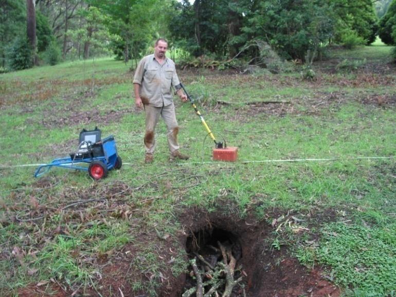
5 Imaging of Subsurface Features Layer profiles Bedrock delineation Overburden calculations / volume Location of buried objects Location of geo-hazards
6 Determination of Geotechnical Parameters Profiling of bedrock depth and material hardness for rippability, tunnelling and piling hardness. Assessment of layer stiffness, elastic moduli, liquefaction potential. In-situ electrical properties for earthing design soil layer resistivity.
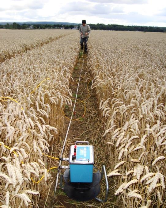
7 Common Methods Seismic MASW Refraction Ground Radar / Geo Radar / GPR Electrical methods EM Conductivity Resistivity

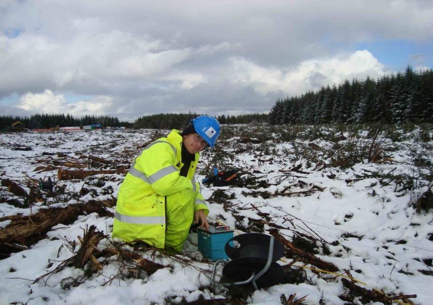
8 MASW Multi channel Analysis of Surface Waves (MASW) 1. Reasonably new technique (6 7 yrs old) 2. Gaining recognition and acceptance as a Geotechnical tool 3. Can be collected as a continuous method 4. Provides information of layers and layer stiffness as 1d or 2d Vs profiles 5. Can use to calculate Poisson ratio and densities of layers 6. Is only good for investigation to approximately 30m

9 Time to learn something!!
10
11

12 1d Vs profiles

13 2d Vs profiles

14 CPT correlation using MASW


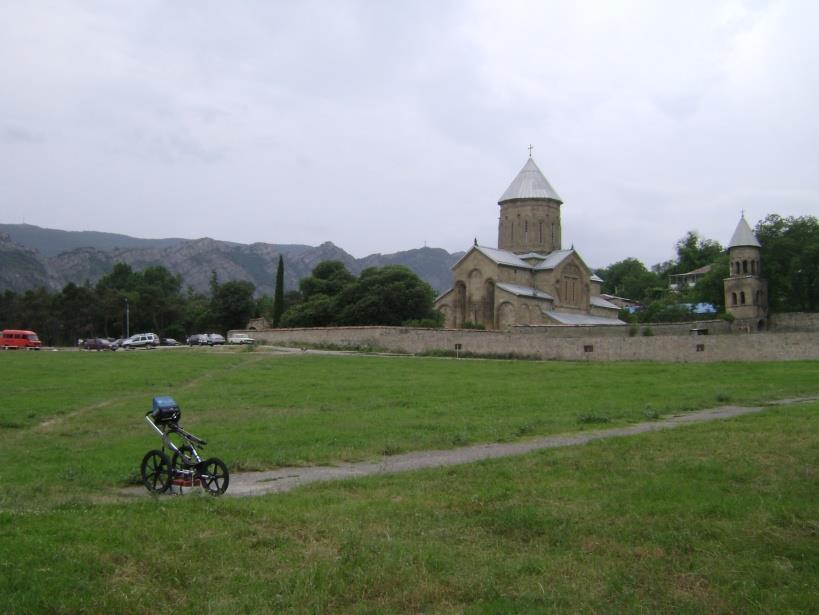
15 example from Pilbara Rail line Culvert Failure
16 Ground Penetrating Radar What is it? A shallow geophysical investigation method some 40yrs old. Is as it sounds! Radio waves or EM energy of specific frequencies are pulsed into the ground 1000 s of times per second. The energy transmits through the ground and is reflected back to a receiver on the surface when there is a change in the electrical properties of the material eg: soil to metal or plastic pipe.
17 Impulse Radar (GPR) GPR Trace GPR Antenna Energy Ground surface Tx Rx Time
18 Impulse Radar (GPR) GPR Trace GPR Antenna Energy Ground surface Tx Rx Time
19 Impulse Radar (GPR) GPR Trace GPR Antenna Energy Ground surface Tx Rx Time
20 Impulse Radar (GPR) GPR Trace GPR Antenna Energy Ground surface Tx Rx Time
21 Impulse Radar (GPR) GPR Trace GPR Antenna Energy Ground surface Tx Rx Time
22 Impulse Radar (GPR) GPR Trace GPR Antenna Energy Ground surface Tx Rx Time
23 Impulse Radar (GPR) GPR Trace GPR Antenna Energy Ground surface Tx Rx Time
24 Impulse Radar (GPR) GPR Trace GPR Antenna Energy Ground surface Tx Rx Time
25 Impulse Radar (GPR) GPR Trace GPR Antenna Energy Ground surface Tx Rx Time
26 Impulse Radar (GPR) GPR Trace GPR Antenna Energy Ground surface Tx Rx Time
27 Impulse Radar (GPR) GPR Trace GPR Antenna Energy Ground surface Tx Rx Time
28 Impulse Radar (GPR) GPR Trace GPR Antenna Energy Ground surface Tx Rx Time
29 Impulse Radar (GPR) GPR Trace GPR Antenna Energy Ground surface Tx Rx Time
30 Impulse Radar (GPR) GPR Trace GPR Antenna Energy Ground surface Tx Rx Time
31 Impulse Radar (GPR) GPR Trace GPR Antenna Energy Ground surface Tx Rx Time
32 Impulse Radar (GPR) GPR Trace GPR Antenna Energy Ground surface Tx Rx Time
33 Impulse Radar (GPR) GPR Trace GPR Antenna Energy Ground surface Tx Rx Time
34 Impulse Radar (GPR) GPR Trace GPR Antenna Energy Ground surface Tx Rx Time
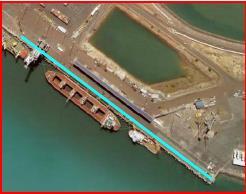
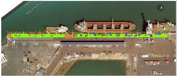
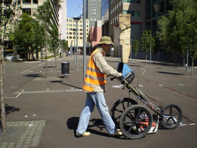
35 Impulse Radar (GPR) GPR Trace GPR Antenna Energy Ground surface Tx Rx Time
36 Impulse Radar (GPR) GPR Trace GPR Antenna Energy Ground surface Tx Rx Time
37 Impulse Radar (GPR) GPR Trace GPR Antenna Energy Ground surface Tx Rx Time
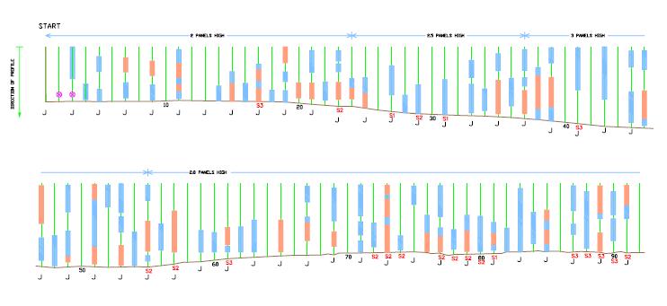
38 Impulse Radar (GPR) GPR Trace GPR Antenna Energy Ground surface Tx Rx Time
39 Impulse Radar (GPR) GPR Trace GPR Antenna Energy Ground surface Tx Rx Time
40 Impulse Radar (GPR) GPR Trace GPR Antenna Energy Ground surface Tx Rx Time
41 Depth and resolution of subsurface targets is frequency dependant. Lower the frequency the better the penetration but the larger the target has to be to observe a reflection from and vis versa. GPR is a continuous scanning method where as the antenna travels over the ground surface scans are recorded at set intervals of between 10mm to 500mm depending on what subsurface information is being sought. Data is digitally recorded at a minimum 16 bit resolution, very large files often result from individual profiles. Targets are identified by virtue of their shape, amplitude and phase as recorded reflections. Depth to targets is calculated from the time taken for the energy to travel too, and be reflected back from the target. This time is multiplied by the velocity of propagation of the radio energy through the material between antenna and target and divided by two to give a distance below the antenna.

42 Darwin East Arm Wharf
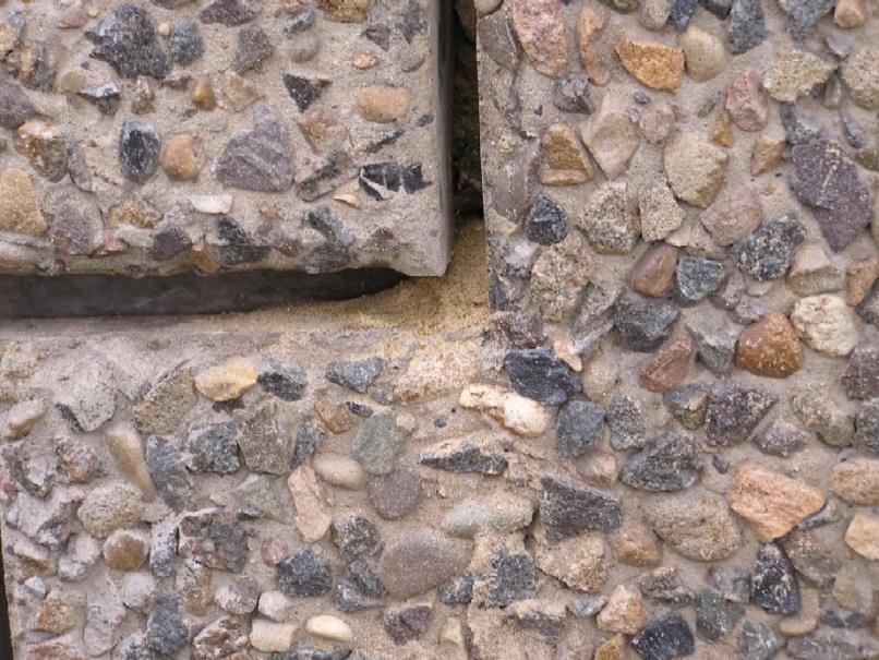
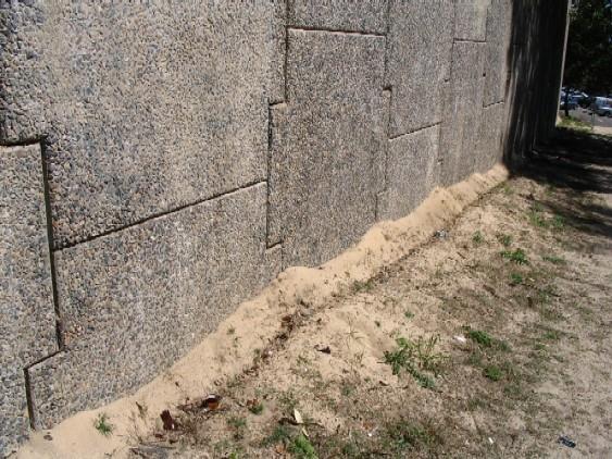
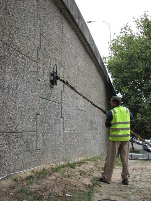
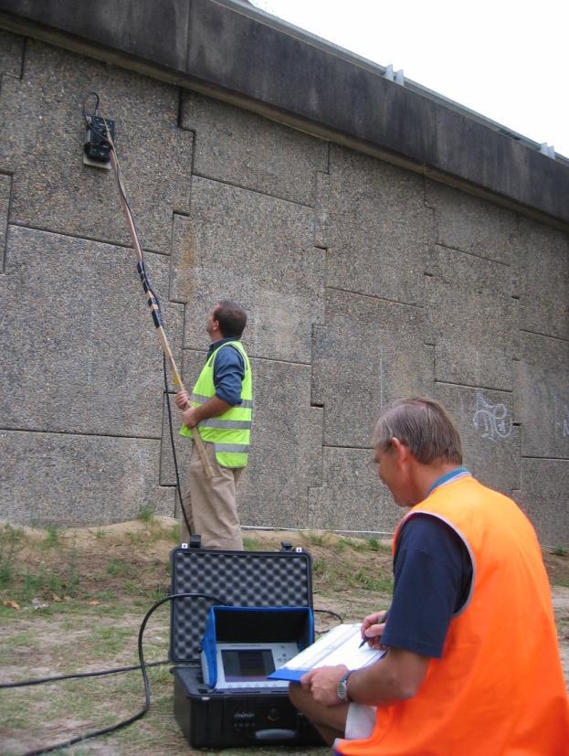
43 Issues! Sheet pile structure with back fill local sands Failure of surface pavement Voids occurring around buried infrastructure Possible lack of compaction of material during construction 250m section to investigate Used Ground Radar and MASW

44

45 Ground Radar Profiles
46 Results
47 MASW profiling

48 MASW Profile
49 Conclusions There is a defined low compaction layer directly under the pavement and it is this that is moving around and appears in some locations to be extending deeper under the structure. This suggests a possible issue with material loss below the water line (tide range here is 7m) and movement through the compacted back fill behind the steel sheet piles. Alternatively, the back fill material may not have achieved compaction during the construction and has since settled and created voiding that has allowed further movement.
50 Sid Enfield Drive Reinforced Earth wall supporting major road Concrete interlocking panels containing compacted sand backfill supporting road pavement, Sand leaking from behind panels How big are possible voids?
51
52

53 Vertical GPR Profile Noticeable increase in amplitude and return reflections increased voiding
54 Results
55 Conclusions The sand movement is occurring within the first 400mm behind the concrete panels and is not effecting the competency of the reinforced earth straps. The sand / fill material deeper in the structure is still compacted and supporting the pavement above. The issue appears to be legacy from construction where inadequate compaction was achieved right up against the rear face of the panels. Over time vibration from the heavy traffic above has loosed the sand which is finding its way out through perished joints.

56 Dam Site Spillway, Qld
57 Issues
58 Construction
59

60 Local Geology
61 Investigation with Ground Radar Area of spillway was 125m x 80m = 10,000m 2 Slopes 1 in 10 and 1in 2 Temperature +36 Cores limited across the site Need to locate voids and undertake investigation of weep drain pipes with CCTV. Provide interpreted report and conclusions
62
63

64 CCTV
65 Results
66 Conclusions Weep drainage poorly designed Main long drains sitting above cross drains so do not continuously drain. Water sits in drains and sediment not flushed Soft friable sandstone / mudstone bedrock possibly dissolving under the gravel drainage layers evident in drains. Removal of the bedrock allows gravel to settle as uncontained causing voids under slabs and movement of clay pipe sections with open joints. Voiding not excessive at present and does appear to be predominantly in the 1 in 2 sloped section.
67 EM Conductivity Testing Method induces current into the ground through the use of an electromagnetic field at set frequencies. Measures the variation in the recorded current caused by the effect of the ground coupling and decay of conductive response. Variations in the sub surface materials poor spaces say from loose gravels, sands to clays will effect a recordable response. Can be used to map large areas quickly to look for: buried material landfill, drums. Geomorphology karstic topo / sink holes Changes in lithology sands and gravels with clays use multiple frequency system to create a profile from different depths to a maximum of 10 15m

68 Rockhampton Levee Investigation
69

70 Ground Conductivity for soil assessment along Levee, Design Route
71 Conclusions Technological advances in computing and modern mobile electronics have never made it easier of cheaper to undertake investigations in the field and get good repeatable information recorded digitally for analysis and interpretation. Geophysical testing methods can provide a much bigger picture investigation technique which, when tied with physical testing for cross correlation is able to fill in the gaps and provide more confident interpretation of subsurface issues. The methods discussed here are rapid and cost effective solutions that can be applied to very large or very small scale investigations.
72 Questions?
Ground Penetrating Radar (GPR) By Dr. Eng. Zubair Ahmed
 By Dr. Eng. Zubair Ahmed") Ground Penetrating Radar (GPR) By Dr. Eng. Zubair Ahmed Acknowledgement Golder Associates, Whitby, Ontario Stantec Consulting, Kitchener, Ontario Infrasense Inc. USA Geophysical Survey Systems Inc. (GSSI),
Ground Penetrating Radar (GPR) By Dr. Eng. Zubair Ahmed Acknowledgement Golder Associates, Whitby, Ontario Stantec Consulting, Kitchener, Ontario Infrasense Inc. USA Geophysical Survey Systems Inc. (GSSI),
7. Consider the following common offset gather collected with GPR.
 Questions: GPR 1. Which of the following statements is incorrect when considering skin depth in GPR a. Skin depth is the distance at which the signal amplitude has decreased by a factor of 1/e b. Skin
Electromagnetic Induction
 Electromagnetic Induction Recap the motivation for using geophysics We have problems to solve Slide 1 Finding resources Hydrocarbons Minerals Ground Water Geothermal Energy SEG Distinguished Lecture slide
Ground Penetrating Radar
 Ground Penetrating Radar Begin a new section: Electromagnetics First EM survey: GPR (Ground Penetrating Radar) Physical Property: Dielectric constant Electrical Permittivity EOSC 350 06 Slide Di-electric
Ground Penetrating Radar (day 1) EOSC Slide 1
 EOSC Slide 1") Ground Penetrating Radar (day 1) Slide 1 Introduction to GPR Today s Topics Setup: Motivational Problems Physical Properties - Dielectric Permittivity and Radiowaves - Microwave Example Basic Principles:
Ground Penetrating Radar (day 1) Slide 1 Introduction to GPR Today s Topics Setup: Motivational Problems Physical Properties - Dielectric Permittivity and Radiowaves - Microwave Example Basic Principles:
Report. Mearns Consulting LLC. Former Gas Station 237 E. Las Tunas Drive San Gabriel, California Project # E
 Mearns Consulting LLC Report Former Gas Station 237 E. Las Tunas Drive San Gabriel, California Project #1705261E Charles Carter California Professional Geophysicist 20434 Corisco Street Chatsworth, CA
GPR SURVEY METHOD. Ground probing radar
 The ground penetrating radar (GPR - Ground Probing Radar) is a geophysical method used to investigate the near surface underground. Thanks to its high degree of resolution, the GPR is the most effective
Geophysical Survey Rock Hill Bleachery TBA Site Rock Hill, South Carolina EP-W EPA, START 3, Region 4 TABLE OF CONTENTS Section Page Signature
 Geophysical Survey Rock Hill Bleachery TBA Site Rock Hill, South Carolina EP-W-05-054 EPA, START 3, Region 4 Prepared for: Tetra Tech EM, Inc. October 12, 2012 Geophysical Survey Rock Hill Bleachery TBA
SURVEYING THE UNDERGROUND
 SURVEYING THE UNDERGROUND An Introduction to ASCE 38-02 and the Practice of Subsurface Utility Engineering ACECMD March 28, 2018 Presented by: Art Worthman A. Morton Thomas & Associates, Inc. John Berrettini
The use of high frequency transducers, MHz, allowing the resolution to target a few cm thick in the first half meter suspect.
 METHODOLOGY GPR (GROUND PROBING RADAR). In recent years the methodology GPR (Ground Probing Radar) has been applied with increasing success under the NDT thanks to the high speed and resolving power. As
GPR Data Acquisition and Interpretation
 1 GPR Data Acquisition and Interpretation Mezgeen Rasol PhD Candidate Geophysics and Seismic Engineering Polytechnic University of Catalonia mezgeen.rasol@upc.edu BIG-SKY-EARTH Cost Action TD143 Workshop
Using GPR Technique Assessment for Study the Sub-Grade of Asphalt and Concrete Conditions
 Using GPR Technique Assessment for Study the Sub-Grade of Asphalt and Concrete Conditions Alaa S. Mahdi Remote Sensing Unit, College of Science, University of Baghdad, Baghdad, Iraq Abstract The Ground
Advances in NDE Technology WHATS NEW?
 Advances in NDE Technology WHATS NEW? Glen Simula, Owner GS Infrastructure, Inc. The state of America s deteriorating infrastructure presses us to find solutions to assess, with limited funds and resources.
Radar Methods General Overview
 Environmental and Exploration Geophysics II Radar Methods General Overview tom.h.wilson tom.wilson@mail.wvu.edu Department of Geology and Geography West Virginia University Morgantown, WV Brown (2004)
An acousto-electromagnetic sensor for locating land mines
 An acousto-electromagnetic sensor for locating land mines Waymond R. Scott, Jr. a, Chistoph Schroeder a and James S. Martin b a School of Electrical and Computer Engineering b School of Mechanical Engineering
Statement of Qualifications
 Revised January 29, 2011 ClearView Geophysics Inc. 12 Twisted Oak Street Brampton, ON L6R 1T1 Canada Phone: (905) 458-1883 Fax: (905) 792-1884 general@geophysics.ca www.geophysics.ca 1 1. Introduction
3D UTILITY MAPPING USING ELECTRONICALLY SCANNED ANTENNA ARRAY. Egil S. Eide and Jens F. Hjelmstad
 D UTILITY MAPPING USING ELECTRONICALLY SCANNED ANTENNA ARRAY Egil S. Eide and Jens F. Hjelmstad Department of Telecommunications Norwegian University of Science and Technology, N-79 Trondheim, Norway eide@tele.ntnu.no
RADAR INSPECTION OF CONCRETE, BRICK AND MASONRY STRUCTURES
 RADAR INSPECTION OF CONCRETE, BRICK AND MASONRY STRUCTURES C.P.Hobbs AEA Industrial Technology Materials and Manufacturing Division Nondestructive Testing Department Building 447 Harwell Laboratory Oxon
Investigation of Bridge Decks Utilizing Ground Penetrating Radar
 Investigation of Bridge Decks Utilizing Ground Penetrating Radar Steve Cardimona *, Brent Willeford *, John Wenzlick +, Neil Anderson * * The University of Missouri-Rolla, Department of Geology and Geophysics
Case Studies and Innovative Uses of GPR for Pavement Engineering Applications
 Case Studies and Innovative Uses of GPR for Pavement Engineering Applications Richard Korczak, MASc., P.Eng., Stantec Consulting Ltd. Amir Abd El Halim, PhD., P.Eng., Stantec Consulting Ltd. Paper prepared
Surface Deployed / Ground Sensors
 Surface Deployed / Ground Sensors WS2 Vibro-acoustics WS3 - Non-Contact Electrical Resistivity techniques WS3 Electromagnetic methods WS4 Detecting changes in the ground Key Achievements and Findings Surface
Advanced Utility Locating Technologies (R01B)
") Advanced Utility Locating Technologies (R01B) Jacob Sheehan Senior Geophysicist Olson Engineering Phil Sirles Principal Geophysicist Olson Engineering Introduction: Utility Bundle Overview SHRP2 Strategic
Advanced Utility Locating Technologies (R01B) Jacob Sheehan Senior Geophysicist Olson Engineering Phil Sirles Principal Geophysicist Olson Engineering Introduction: Utility Bundle Overview SHRP2 Strategic
GPR SYSTEM USER GUIDE AND TROUBLESHOOTING GUIDE
 GPR SYSTEM USER GUIDE AND TROUBLESHOOTING GUIDE Implementation Report 5-4414-01-1 Project Number 5-4414-01 Subsurface Sensing Lab Electrical and Computer Engineering University of Houston 4800 Calhoun
Exploration Beyond Expectation. Geo-Carte Radar Technology Pvt. Ltd.
 Exploration Beyond Expectation Geo-Carte Radar Technology Pvt. Ltd. Problem Unknown distribution network of underground pipeline in India 32% Damage of pre-existing underground utilities during laying
Tri-band ground penetrating radar for subsurface structural condition assessments and utility mapping
 Tri-band ground penetrating radar for subsurface structural condition assessments and utility mapping D. Huston *1, T. Xia 1, Y. Zhang 1, T. Fan 1, J. Razinger 1, D. Burns 1 1 University of Vermont, Burlington,
1. Report No. FHWA/TX-05/ Title and Subtitle PILOT IMPLEMENTATION OF CONCRETE PAVEMENT THICKNESS GPR
 1. Report No. FHWA/TX-05/5-4414-01-3 4. Title and Subtitle PILOT IMPLEMENTATION OF CONCRETE PAVEMENT THICKNESS GPR Technical Report Documentation Page 2. Government Accession No. 3. Recipient s Catalog
November 13, Hindu Temple, LTD Arbor Street Omaha, Nebraska Attn: Subject:
 November 13, 2017 Hindu Temple, LTD 13010 Arbor Street Omaha, Nebraska 68144-0000 Attn: Subject: Srini Mallipudi / mallipudis@gmail.com Underground Utility Survey Report Hindu Temple - 13010 Arbor Street,
Archaeo-Geophysical Associates, LLC
 Geophysical Survey at the Parker Cemetery Rockwall, Texas. AGA Report 2010-6 Report Submitted To: Texas Cemetery Restoration 10122 Cherry Tree Dr. Dallas, Texas 75243 May 14, 2010 Chester P. Walker, Ph.D.
L O C A T O R G P R. Introducing the. Radarteam. Ground Probing Radar/Antenna system with Rugged PC and Cart ü
 Introducing the L O C A T O R G P R Ground Probing Radar/Antenna system with Rugged PC and Cart ü Fully integrated system. Multi Frequency operation: 100-900 MHz ü Air/Ground Coupled operation. Multiple
European Scientific Journal February 2014 /SPECIAL/ edition vol.3 ISSN: (Print) e - ISSN
 e - ISSN") HIGH PRECISION CALCULATION OF MOVE OUT CORRECTION IN GPR MEASUREMENTS Janis Karuss, M.Sc. University of Latvia, Latvia Abstract Ground penetrating radar (GPR) is a non-invasive geophysical method that
HIGH PRECISION CALCULATION OF MOVE OUT CORRECTION IN GPR MEASUREMENTS Janis Karuss, M.Sc. University of Latvia, Latvia Abstract Ground penetrating radar (GPR) is a non-invasive geophysical method that
THE BEST GPR DATA QUALITY AT THE BEST PRICE! GROUND PENETRATING RADAR ZOND-12e G R O U N D P E N E T R A T I N G R A D A R S
 GROUND PENETRATING RADAR ZOND-12e General Purpose Pulse GPR ZOND-12e SINGLE CHANNEL OR ADVANCED CONTROL UNITS ZOND 12e GPR is a portable digital Ground Penetrating Radar carried by a single operator. The
Detection of Obscured Targets
 Detection of Obscured Targets Waymond R. Scott, Jr. and James Mcclellan School of Electrical and Computer Engineering Georgia Institute of Technology Atlanta, GA 30332-0250 waymond.scott@ece.gatech.edu
SURVEYING THE UNDERGROUND
 SURVEYING THE UNDERGROUND An Introduction to the Practice of Subsurface Utility Engineering Maryland Society of Surveyors Maryland Society of Professional Engineers Joint Conference October 8, 2015 Michael
Nondestructive Testing of Drilled Shaft Foundations
 Nondestructive Testing of Drilled Shaft Foundations Magued Iskander, PhD, PE, F.ASCE Why NDT for Integrity? Drilled shafts cannot be visually inspected after construction Load tests are expensive - only
REBAR DETECTION USING GPR: AN EMERGING NON DESTRUCTIVE QC APPROACH
 REBAR DETECTION USING GPR: AN EMERGING NON DESTRUCTIVE QC APPROACH D.C.Bala*, R.D.Garg** and S.S. Jain*** *(Research scholar, Centre for Transportation Systems (CTRANS), IIT Roorkee, Roorkee-247667, India
GeoRadar Division. GPR for Archeology and Cultural Heritage. GeoRadar Division. GPR Configuration for Archeology and Cultural Heritage Application
 GeoRadar Division GPR Configuration for Archeology and Cultural Heritage Application We believe that the Archaeological patrimony and the Cultural Heritage are one of the most important aspect of this
SEEING THE UNKNOWN - The Use of GPR in Civil Engineering
 SEEING THE UNKNOWN - The Use of GPR in Civil Engineering Emilio M. Morales CE, MSCE, F.ASCE, F. ASEP, F. PICE 1 Mark K. Morales CE, MSc 2 ABSTRACT: Civil Engineers are always confronted by the uncertainties
COBRA CBD UNPARALLELED QUALITY GPR DATA WITHOUT BLIND SPOTS
 COBRA CBD WIRELESS GPR Introducing the smart CBD ANTENNA Triple frequency 200/400/800 MHz Outstanding 50-1400 MHz bandwidth Replaces several conventional antennas UNPARALLELED QUALITY GPR DATA WITHOUT
GPR based Detection of Structurally Weak Zones of Road Pavement
 2012 International Conference on Traffic and Transportation Engineering (ICTTE 2012) IPCSIT vol. 26 (2012) (2012) IACSIT Press, Singapore GPR based Detection of Structurally Weak Zones of Road Pavement
L A N D R A Y P R O D U C T 1 BREAKTHROUGH PERFORMANCE BY GROUND PENETRATING RADAR
 L A N D R A Y P R O D U C T 1 BREAKTHROUGH PERFORMANCE BY GROUND PENETRATING RADAR 03.2009 Contents LandRay s Business Purpose 3 NEW GENERATION System Requisites 4 LandRay PRODUCT1 best Addresses Unmet
Identifying shallow subsurface stratigraphy and voids using dispersive characteristics of electromagnetic and surface waves
 Scholars' Mine Doctoral Dissertations Student Theses and Dissertations Fall 2016 Identifying shallow subsurface stratigraphy and voids using dispersive characteristics of electromagnetic and surface waves
Module 6 : Design of Retaining Structures. Lecture 30 : Dewatering [ Section 30.1 : Introduction ]
![Module 6 : Design of Retaining Structures. Lecture 30 : Dewatering [ Section 30.1 : Introduction ]](/thumbs/78/77377713.jpg "Module 6 : Design of Retaining Structures. Lecture 30 : Dewatering [ Section 30.1 : Introduction ]") Lecture 30 : Dewatering [ Section 30.1 : Introduction ] Objectives In this section you will learn the following Introduction Lecture 30 : Dewatering [ Section 30.1 : Introduction ] Introduction Dewatering
Lecture 30 : Dewatering [ Section 30.1 : Introduction ] Objectives In this section you will learn the following Introduction Lecture 30 : Dewatering [ Section 30.1 : Introduction ] Introduction Dewatering
ARCHAEOLOGICAL GEOPHYSICS: SENSOR SELECTION AND SITE SUITABILITY
 ARCHAEOLOGICAL GEOPHYSICS: SENSOR SELECTION AND SITE SUITABILITY A SPARC Webinar presented on October 17, 2014 Eileen G. Ernenwein, PhD ETSU: http://faculty.etsu.edu/ernenwei/ CAST: http://goo.gl/wyzlp
VIBRATIONAL TESTING OF A FULL-SCALE PILE GROUP IN SOFT CLAY
 VIBRATIONAL TESTING OF A FULL-SCALE PILE GROUP IN SOFT CLAY Marvin W HALLING 1, Kevin C WOMACK 2, Ikhsan MUHAMMAD 3 And Kyle M ROLLINS 4 SUMMARY A 3 x 3 pile group and pile cap were constructed in a soft
EKKO_Project is the all-inclusive software SUBSURFACE VIEWS. EKKO_Project V4 Released. In this issue GPR INNOVATIONS HARDWARE AND SOFTWARE
 SUBSURFACE VIEWS GPR INNOVATIONS HARDWARE AND SOFTWARE In this issue 1, 2, 3 EKKO_Project V4 Released 3, 4 EAGE 2015 Boot Camp 5, 6 TIPS: Using the Water Table to Add Topography January, 2016 - Vol. 12,
SEA SELF DRILLING, THREADED, HOLLOW BAR / GROUT-ABLE SOIL NAILS / ANCHORS
 SEA SELF DRILLING, THREADED, HOLLOW BAR / GROUT-ABLE SOIL NAILS / ANCHORS THE SEA SYSTEM SEA hollow T threaded bar Rock Anchors / Soil Nails provide the ultimate solution for securing unstable embankments
Appendix I Geophysical Survey
 DRAFT IRM PRE- DESIGN INVESTIGATION DATA SUMMARY REPORT NATIONAL GRID FULTON MUNICIPAL WORKS FORMER MGP SITE APRIL 2013 Appendix I Geophysical Survey GEOPHYSICAL SURVEY FULTON MUNICIPAL WORKS FORMER MGP
We are IntechOpen, the world s leading publisher of Open Access books Built by scientists, for scientists. International authors and editors
 We are IntechOpen, the world s leading publisher of Open Access books Built by scientists, for scientists 3,500 108,000 1.7 M Open access books available International authors and editors Downloads Our
Seismic Reflection Method
 1 of 25 4/16/2009 11:41 AM Seismic Reflection Method Top: Monument unveiled in 1971 at Belle Isle (Oklahoma City) on 50th anniversary of first seismic reflection survey by J. C. Karcher. Middle: Two early
GPR Part II: Effects of conductivity. Surveying geometries. Noise in GPR data. Summary notes with essential equations. Some Case histories
 GPR Part II: Effects of conductivity Surveying geometries Noise in GPR data Summary notes with essential equations Some Case histories EOSC 350 06 Slide 1 GPR Ground Penetrating Radar R = ε ε 2 2 + ε ε
Ground Penetrating Radar
 REPORT 4A Ground Penetrating Radar Introduction to GPR, and positioning of GPR data Part of R&D project Infrastructure in 3D in cooperation between Innovation Norway, Trafikverket and TerraTec Yta för
Pitfalls in GPR Data Interpretation: Differentiating Stratigraphy and Buried Objects from Periodic Antenna and Target Effects
 GEOPHYSICAL RESEARCH LETTERS, VOL. 27, NO. 20, PAGES 3393-3396, OCTOBER 15, 2000 Pitfalls in GPR Data Interpretation: Differentiating Stratigraphy and Buried Objects from Periodic Antenna and Target Effects
A Report on the Ground Penetrating Radar Survey 205 Little Plains Road Southampton, NY
 A Report on the Ground Penetrating Radar Survey 205 Little Plains Road Southampton, NY November 18, 2016 Conducted by Robert W. Perry TOPOGRAPHIX, LLC Hudson, NH Requested by Southampton Town Historical
GPR Investigation: Post Tension Cable Mapping
 CMD Civil Pty Ltd PO Box 1119 Huntingdale VIC 3166 +61 3 9544 8833 info@cmdcivil.com www.cmdcivil.com Case Study: GPR Investigation: Post Tension Cable Mapping This application note demonstrates an example
ScienceDirect. A comparison of dielectric constants of various asphalts calculated from time intervals and amplitudes
 Available online at www.sciencedirect.com ScienceDirect Procedia Engineering 111 (2015 ) 660 665 XXIV R-S-P seminar, Theoretical Foundation of Civil Engineering (24RSP) (TFoCE 2015) A comparison of dielectric
GPR ANTENNA ARRAY FOR THE INSPECTION OF RAILWAY BALLAST
 Proceedings of the National Seminar & Exhibition on Non-Destructive Evaluation NDE 2011, December 8-10, 2011 GPR ANTENNA ARRAY FOR THE INSPECTION OF RAILWAY BALLAST Th. Kind BAM Federal Institute for Materials
FUGRO GROUP BUILDING AND INFRASTRUCTURE. TACKLING your complex challenges. UNDERSTANDING your operational objectives
 BUILDING AND INFRASTRUCTURE FUGRO GROUP UNDERSTANDING your operational objectives TACKLING your complex challenges DELIVERING your global success stories BUILDING AND INFRASTRUCTURE With a wide variety
Applied Geophysics Nov 2 and 4
 Applied Geophysics Nov 2 and 4 Effects of conductivity Surveying geometries Noise in GPR data Summary notes with essential equations Some Case histories EOSC 350 06 Slide 1 GPR Ground Penetrating Radar
A. Dewatering observation wells are part of dewatering allowance.
 SECTION 312319 - DEWATERING PART 1 - GENERAL 1.1 RELATED DOCUMENTS A. Drawings and general provisions of the Contract, including General and Supplementary Conditions and Division 01 Specification Sections,
Recording seismic reflections using rigidly interconnected geophones
 GEOPHYSICS, VOL. 66, NO. 6 (NOVEMBER-DECEMBER 2001); P. 1838 1842, 5 FIGS., 1 TABLE. Recording seismic reflections using rigidly interconnected geophones C. M. Schmeissner, K. T. Spikes, and D. W. Steeples
PRINCIPLE OF SEISMIC SURVEY
 PRINCIPLE OF SEISMIC SURVEY MARINE INSTITUTE Galway, Ireland 29th April 2016 Laurent MATTIO Contents 2 Principle of seismic survey Objective of seismic survey Acquisition chain Wave propagation Different
In search of a Historic Grave: GPR Investigation near the Yellowstone Lake Store: 7/15/2010
 In search of a Historic Grave: GPR Investigation near the Yellowstone Lake Store: 7/15/2010 Steven Sheriff Professor of Geophysics Department of Geosciences University of Montana Missoula, Montana Introduction
Geopier Foundation Company, Inc.
 Geopier Foundation Company, Inc. 800.371.7470 www.geopier.com 4_2006 g e o p i e r f o u n d a t i o n c o i n c t e c h n i c a l b u l l e t i n N o. 9 v i b r a t i o n a n d n o i s e l e v e l s Construction
ESTIMATION OF REBAR DIAMETER IN CONCRETE STRUCTURAL ELEMENTS USING GROUND PENETRATING RADAR
 More info about this article: http://www.ndt.net/?id=21143 ESTIMATION OF REBAR DIAMETER IN CONCRETE STRUCTURAL ELEMENTS USING GROUND PENETRATING RADAR Bhaskar Sangoju and Ramanjaneyulu, K. Scientists,
Experiment on Artificial Frozen Soil Boundary GPR Detection During Cross-passage Construction in Tunnels
 354 Progress In Electromagnetics Research Symposium 2005, Hangzhou, China, August 22-26 Experiment on Artificial Frozen Soil Boundary GPR Detection During Cross-passage Construction in Tunnels Yong-Hui
B422 - PRECAST REINFORCED CONCRETE BOX CULVERTS AND BOX SEWERS - OPSS 422
 B422 - PRECAST REINFORCED CONCRETE BOX CULVERTS AND BOX SEWERS - OPSS 422 422.1 GENERAL The work under these tender items consists of the fabrication and installation in open cut of precast reinforced
SECTION DEWATERING PART 1 - GENERAL 1.1 RELATED DOCUMENTS
 SECTION 312319 - DEWATERING PART 1 - GENERAL 1.1 RELATED DOCUMENTS A. Drawings and general provisions of the Contract, including General and Supplementary Conditions and Division 01 Specification Sections,
SIR, UtilityScan and RADAN are registered trademarks of Geophysical Survey Systems, Inc.
 Copyright 2016-2017 Geophysical Survey Systems, Inc. All rights reserved including the right of reproduction in whole or in part in any form Published by Geophysical Survey Systems, Inc. 40 Simon Street
Precast Concrete. Installation Guide V GR-WI-599. Page 1
 Precast Concrete Installation Guide V.1 2019 GR-WI-599 Page 1 Introduction Cubis Systems designs, manufactures and distributes a wide range of precast concrete cable pits and access covers for all major
Propagation and attenuation characteristics of various ground vibrations
 Soil Dynamics and Earthquake Engineering 19 (2000) 115 126 www.elsevier.com/locate/soildyn Propagation and attenuation characteristics of various ground vibrations Dong-Soo Kim a, *, Jin-Sun Lee 1,a a
P Forsmark site investigation. RAMAC and BIPS logging in borehole HFM11 and HFM12
 P-04-39 Forsmark site investigation RAMAC and BIPS logging in borehole HFM11 and HFM12 Jaana Gustafsson, Christer Gustafsson Malå Geoscience AB/RAYCON March 2004 Svensk Kärnbränslehantering AB Swedish
SIMULATION OF GPR SCENARIOS USING FDTD
 SIMULATION OF GPR SCENARIOS USING FDTD 1 GAMIL ALSHARAHI, 2 ABDELLAH DRIOUACH, 3 AHMED FAIZE 1,2 Department of physic, Abdelmalek Essaâdi University, Faculty of sciences, Morocco 3 Department of physic,
Visual inspection and ground penetrating radar investigation of the historical Pulaski County Poor Farm Cemetery
 Scholars' Mine Masters Theses Student Theses and Dissertations Fall 2011 Visual inspection and ground penetrating radar investigation of the historical Pulaski County Poor Farm Cemetery Ibrahim Elshiekh
Chirp Sonar and Electrical Resistivity Imaging survey for integrity of concrete lining in a Hydel Channel
 J. Ind. Chirp Geophys. Sonar Union and Electrical ( April Resistivity 2015 ) Imaging survey for integrity of concrete lining in a Hydel Channel v.19, no.2, pp:167-174 Chirp Sonar and Electrical Resistivity
Understanding Seismic Amplitudes
 Understanding Seismic Amplitudes The changing amplitude values that define the seismic trace are typically explained using the convolutional model. This model states that trace amplitudes have three controlling
Geology 228/378 Environmental Geophysics Lecture 10. Electromagnetic Methods (EM) I And frequency EM (FEM)
 I And frequency EM (FEM)") Geology 228/378 Environmental Geophysics Lecture 10 Electromagnetic Methods (EM) I And frequency EM (FEM) Lecture Outline Introduction Principles Systems and Methods Case Histories Introduction Many EM
Geology 228/378 Environmental Geophysics Lecture 10 Electromagnetic Methods (EM) I And frequency EM (FEM) Lecture Outline Introduction Principles Systems and Methods Case Histories Introduction Many EM
CAVE DETECTION USING SEISMIC METHODS AT MADISON BLUE SPRING STATE PARK, MADISON COUNTY, FLORIDA
 Michigan Technological University Digital Commons @ Michigan Tech Dissertations, Master's Theses and Master's Reports 2016 CAVE DETECTION USING SEISMIC METHODS AT MADISON BLUE SPRING STATE PARK, MADISON
John J. Bowders Civil Engineering, University of Missouri-Columbia, Columbia, MO, USA
 RMK Symposium, Drexel University, September 13, 2004 NONDESTRUCTIVE EVALUATION METHODS John J. Bowders Civil Engineering, University of Missouri-Columbia, Columbia, MO, USA ABSTRACT Professor Robert M.
SECTION DEWATERING TANKAGE PART 1 - GENERAL 1.1 RELATED DOCUMENTS
 SECTION 31 23 19 - DEWATERING TANKAGE PART 1 - GENERAL 1.1 RELATED DOCUMENTS A. Drawings and general provisions of the Contract, including General and Supplementary Conditions and Division 1 Specification
Increasing the Probability of Detection and Evaluation of Buried Metallic Objects by Data Fusion GPR- Low Frequency Electromagnetic Sensor Array
 4th European-American Workshop on Reliability of NDE - Poster 4 Increasing the Probability of Detection and Evaluation of Buried Metallic Objects by Data Fusion GPR- Low Frequency Electromagnetic Sensor
STORM M ANHOLE FOR 42" PIPE AND SM ALLER JOB NO. SHEET NO. DATE MARCH 2015 OF MIN OF 3 CRSES MAX OF 5 CRSES 30"MAX 3 OR 3.5 PRECAST ECCENTIC CONC
 01-APR-2015 13:33 = I:\MSV8i\Plotting\piblack.ptb V:\201001\\C\8x11_Howell_Det\stm_det01_8x11_st01.dgn TIME = MIN 3 CRSES MAX 5 CRSES 3 OR 3.5 PRECAST ECCENTIC CONC ID PIPE GRADE A CONC FILL 4" 8" 2-0"SUMP
Laboratory measurement of fragmented ore bulk density using ground penetrating radar
 Author(s): Benter, A.M. ; Moore, W. ; Antolovich, M. Title: Laboratory measurement of fragmented ore bulk density using ground penetrating radar Journal: Mining Technology: Transactions of the Institute
Surface wave analysis for P- and S-wave velocity models
 Distinguished Lectures in Earth Sciences, Napoli, 24 Maggio 2018 Surface wave analysis for P- and S-wave velocity models Laura Valentina Socco, Farbod Khosro Anjom, Cesare Comina, Daniela Teodor POLITECNICO
Determine the Thickness of Pavement Layers Variety Using GPR Technique in Some Sites at University of Kufa, Najaf, Iraq
 International Journal of ChemTech Research CODEN (USA): IJCRGG, ISSN: 0974-4290, ISSN(Online):2455-9555 Vol.10 No.2, pp 837-843, 2017 Determine the Thickness of Pavement Layers Variety Using GPR Technique
Module 5 : Design of Deep Foundations. Lecture 20 : Introduction [ Section 20.1 : Introduction ]
![Module 5 : Design of Deep Foundations. Lecture 20 : Introduction [ Section 20.1 : Introduction ]](/thumbs/82/86090197.jpg "Module 5 : Design of Deep Foundations. Lecture 20 : Introduction [ Section 20.1 : Introduction ]") Lecture 20 : Introduction [ Section 20.1 : Introduction ] Objectives In this section you will learn the following Introduction Lecture 20 : Introduction [ Section 20.1 : Introduction ] INTRODUCTION The
Lecture 20 : Introduction [ Section 20.1 : Introduction ] Objectives In this section you will learn the following Introduction Lecture 20 : Introduction [ Section 20.1 : Introduction ] INTRODUCTION The
HIGH FREQUENCY MASW FOR NON-DESTRUCTIVE TESTING OF PAVEMENTS ACCELEROMETER APPROACH. Abstract
 HIGH FREQUENCY MASW FOR NON-DESTRUCTIVE TESTING OF PAVEMENTS ACCELEROMETER APPROACH Downloaded 07/03/14 to 129.237.143.20. Redistribution subject to SEG license or copyright; see Terms of Use at http://library.seg.org/
Design of Geophysical Surveys in Transportation
 Boise State University ScholarWorks CGISS Publications and Presentations Center for Geophysical Investigation of the Shallow Subsurface (CGISS) 1-1-2004 Design of Geophysical Surveys in Transportation
Chapter 4 Results. 4.1 Pattern recognition algorithm performance
 94 Chapter 4 Results 4.1 Pattern recognition algorithm performance The results of analyzing PERES data using the pattern recognition algorithm described in Chapter 3 are presented here in Chapter 4 to
RECONSTRUCTION OF BURIED OBJECTS BY IMPLEMENTATION OF GROUND PENETRATING RADAR TECHNIQUE: EXAMPLE ON ROMAN TOMB IN BRESTOVIK (SERBIA)
") Geoarchaeology and Archaeomineralogy (Eds. R. I. Kostov, B. Gaydarska, M. Gurova). 2008. Proceedings of the International Conference, 29-30 October 2008 Sofia, Publishing House St. Ivan Rilski, Sofia,
Geoarchaeology and Archaeomineralogy (Eds. R. I. Kostov, B. Gaydarska, M. Gurova). 2008. Proceedings of the International Conference, 29-30 October 2008 Sofia, Publishing House St. Ivan Rilski, Sofia,
Active Radio Frequency Sensing for Soil Moisture Retrieval
 Active Radio Frequency Sensing for Soil Moisture Retrieval T. Pratt and Z. Lin University of Notre Dame Other Contributors L. Leo, S. Di Sabatino, E. Pardyjak Summary of DUGWAY Experimental Set-Up Deployed
Test Pitting Guide. Contents: What is a test pit? Why do we use test pitting in archaeology? How do we do it? Big Heritage
 Test Pitting Guide Contents: What is a test pit? Why do we use test pitting in archaeology? How do we do it? 1 What is a test pit? A test-pit is a small trench, usually 1x1m, excavated to the natural geology.
Ground Penetrating Radar: Impulse and Stepped Frequency
 Ground Penetrating Radar: Impulse and Stepped Frequency Carey M. Rappaport Professor Elect. and Comp. Engineering Northeastern University CenSSIS Workshop SW3, November 15, 2 Center for Subsurface Sensing
SPECIFICATIONS FOR THE INSTALLATION OF CONDUIT SYSTEMS IN RESIDENTIAL SUBDIVISIONS. Notification of Completed Conduit Sections
 SPECIFICATIONS FOR THE INSTALLATION OF CONDUIT SYSTEMS IN RESIDENTIAL SUBDIVISIONS Section 1 Definitions 2 Scope of Work 3 Extent of Work 4 Inspection and Performance of Work 5 Trenching 6 Duct Installation
Using ground penetrating radar to quantify changes in the fracture pattern associated with a simulated rockburst experiment
 Using ground penetrating radar to quantify changes in the fracture pattern associated with a simulated rockburst experiment by M. Grodner* Synopsis Ground Penetrating Radar (GPR) is an electromagnetic
Experimental investigation of the acousto-electromagnetic sensor for locating land mines
 Proceedings of SPIE, Vol. 3710, April 1999 Experimental investigation of the acousto-electromagnetic sensor for locating land mines Waymond R. Scott, Jr. a and James S. Martin b a School of Electrical
a step change in Ground Penetrating Radar technology Guido Manacorda Engineering Manager
 The ORFEUS Project: a step change in Ground Penetrating Radar technology to locate buried utilities Guido Manacorda Engineering Manager IDS Ingegneria dei Sistemi i SpA Key issues Many ypp pipes and cables
Block Foundation. From the 1950s through the 80s. Hydraulically driven. piers provide bearing. for a settling foundation
 RESCUING FIXING A A Block Foundation Hydraulically driven piers provide bearing for a settling foundation From the 1950s through the 80s before poured concrete became the norm many homes in northern New
GCM mapping Vildbjerg - HydroGeophysics Group - Aarhus University
 GCM mapping Vildbjerg - HydroGeophysics Group - Aarhus University GCM mapping Vildbjerg Report number 06-06-2017, June 2017 Indholdsfortegnelse 1. Project information... 2 2. DUALEM-421s... 3 2.1 Setup
Limit Equilibrium including Shear Capacity for Launched Soil Nails. Matthew Birchmier, P.E.
 Limit Equilibrium including Shear Capacity for Launched Soil Nails Matthew Birchmier, P.E. The Soil Nail Launcher Declassified British Military Cannon modified to Launch Soil Nails War on shallow landslides
transmit foundation loads
 PILES Long, slender members that transmit foundation loads through soil strata of low bearing capacity or through water to deeper soil or rock strata having a high bearing capacity. End bearing piles End