Mobile Survey of Rail Track and Bed
|
|
|
- Lindsey Blankenship
- 6 years ago
- Views:
Transcription
1 Mobile Survey of Rail Track and Bed DOT - FRA December 2, 2008 William J. Herr, MSEE, PE wherr@phnx-sci.com

")

2 Pavement Profile Scanner (PPS) Fast Accurate Available
3 Polygon Scanner Polygonal Scan Mirror 10,000 R.P.M x 6 sides = 1 Khz Scan rate = 1 inch between scans at 60 mph Collection optics Transmitter: Modulated Laser Detector 90 Field-of-View Scan Width is twice height At 7 feet coverage is14 feet
4 PPS Performance Spec Phase Laser Radar (Class IIIB ) Developed for high speed pavement survey Million Points per Second 950 Points per scan 0.15 to 0.28 inches between points ±0.02 inch Accuracy at MSPS Precision + Bias Peak to peak, not rms.
5 Applications Rolling Wheel Deflection Technology Driver Rut and Ride Rut Bar Replacement (IRI) Texture, Distress Correlation, Shoulder Mobile Mapping Precision DTM Road Design, Vehicle Dynamics


6 Development Prototypes for RWD USACE-WES SBIR funded development. Rutting for LTPP Westrack 1997 PSI Patented RWD Roll-by Deflection Demonstrated FHWA(ARA) SBIR Rolling Wheel Deflectometer (RWD) Ohio 1999 Single Scanner Used

7 Road Condition Testing Units In-service since October 2002


8 Manhole Sequence Amplitude 75 scans in seconds at 64 KPH Profile RaisedMarker Plot Courtesy Mandli Comminucations Screen Capture of Scan Display Cropped to zoom on manhole Screen Capture

 LA Area")


9 2005 Road Survey Road Reproduction for Ride Testing (BMW) LA Area (405) Impossible to close road Fine Grain DTM Joints Faults Slab angles Distress

10 Caltrans: I-15 Reversible HOV Lanes Dave Olander Caltrans District 11 Survey Two HOV Lanes 1.8 Km with overpass Shoulders and K-rails Extensive Controls Surveyed during midday direction reversal Cross section every 5 meters 5-10 points per cross section


11 Caltrans: I-15 Reversible HOV Lanes Permanent Control Used for conventional and mobile survey Navigation Differential GPS Inertial Kalman Filtering

12 KDOT I-135 Project August 2007 Mike Frecks, Optira Survey Expertise Terrestrial scanning experience Quest for mobile scanning PEC/Kansas DOT 6.8 miles 7 overpasses 3/4 lanes + shoulders Gore areas


13 I-135 Project Control 280 points Inner & outer shoulders North & South bound Every 500 feet
14 Rumble Strip Topology Full Resolution Every Scan (~1/in.) Every Point (av 0.2 in.)

15 Integral Boresighted IMU Factory Alignment Self Contained Transport by Air Freight Easy Intallation


16 Rugged Terrain Using New DSB
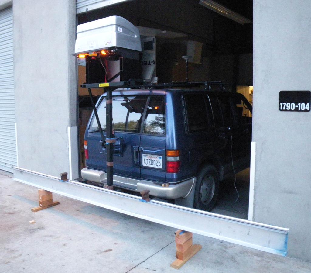


17 Improvised Rail Test Phoenix Scientific Inc.
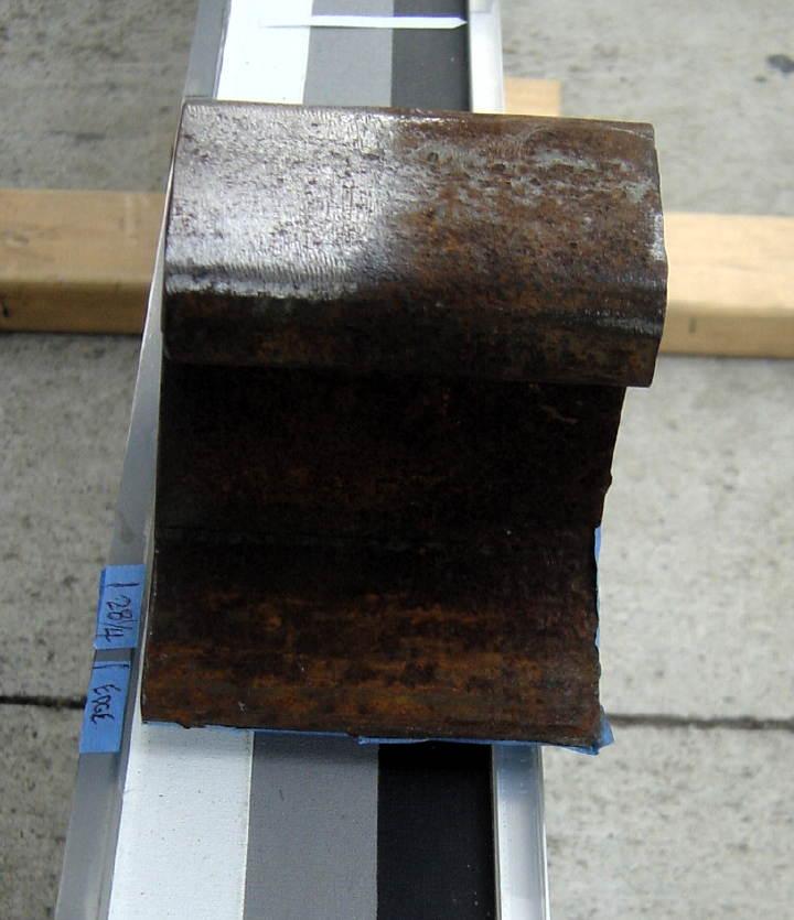
18 Rail Sample
19 Real-time Display
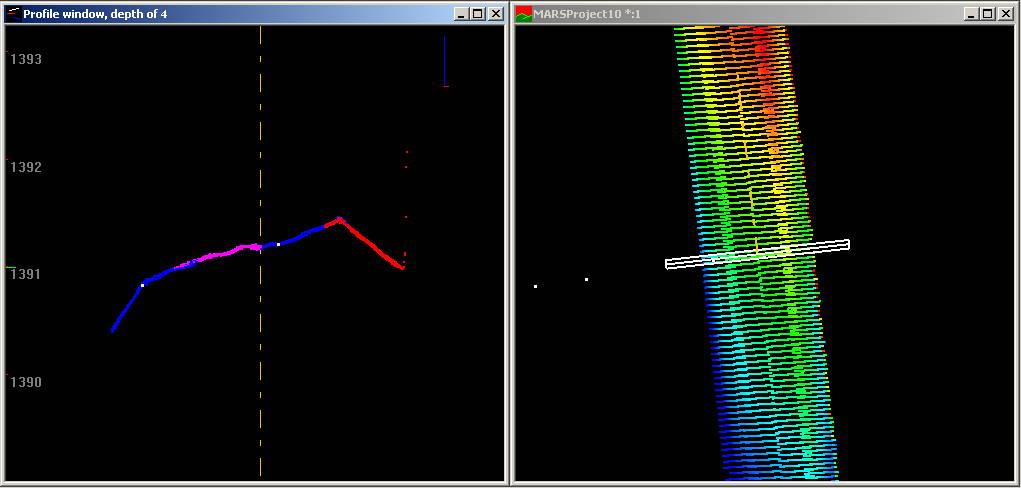
20 5 Scatter Plot Run 6 Scan Elevation (inches) Transverse Position (inches)
21 5 Scatter Plot Run 6 Scan 10 4 Elevation (inches) Transverse Position (inches)
22 Rail Measurement Requirements Field of View Rails, Rail Bed, Surrounding Accuracy Structure, Relative Orientation, Geodetic Position Frequency Point Density: Transverse and Longitudinal Latency: Real-time vs. Post-Processed

23 Rail Scanning Concept
24 Optional Additional Information
25 Aerial Lidar Software Profile Window Profile Box at Northing feet 1 Foot Merrick Advanced Remote Sensing Software MARS


26 Control with Point Cloud Hidden 1 Foot Control Points (4) white pixels
 ~220 points/scan (~25%) (20 cm grid) ~1 scan")
27 Scan Inspection 1 Foot Decimation (~0.75%) ~220 points/scan (~25%) (20 cm grid) ~1 scan per 3 feet (~3%)

28 Color Coded Runs 1 Foot Points Tagged with Time or Scan Number

29 3 and 4 Lane Samples


30 Full Resolution Example Recessed Rumble Strip One Run Straddling Shoulder Divots ~ 6x12 inches ~ 10 inch spacing

31 Rumble Strip Cross section 1 Foot ~0.75 inches
32 Rumble Strip Topology Full Resolution Every Scan (~1/in.) Every Point (av 0.2 in.)
 Vtech (VTPL), Dr.")
33 Rough Terrain TACOM High Mobility Multipurpose Wheeled Vehicle (HMMWV) Vtech (VTPL), Dr. John Ferris Photographed by John McCormick


34 Integrated New Design DSB Ambiguity 3.2 meters Embedded Novatel SPAN Interface FPGA Network Provision (Gigabit Ethernet) Max Rate MSPS
35 Summary Survey grade mobile survey a reality Enabled by PSI Scanner Unparalleled accuracy & speed Inertial aided Differential GPS Navigation Survey control tailored to requirements Options for Technology Deployment Service Sale of sensors and systems Partnering, Licensing and Acquisition


36 Tinned PCC
37 Elevation (inches) Longitudinal Tinning and Faulting Jointed PCC (I5N) worn in wheel path Joint Fault ~60mils Scan Scan Signal Level Binning eliminates tinning effect on LP/IRI Edge of slab joint Transverse Position (inches) Edge of lane line Signal (max 500 mv)

38 LP/Ride in Urban Stop-and-Go Traffic Speed Independent LP w/o an accelerometer Ohio Test Road 1999 LVDT s and Start of overlay

39 Longitudinal Scanning TRL Emulation of HRM Processing Emulate HRM with discrete points Use all points to maximize performance Uses Urban stop & go True reference profiles
Pavemetrics. LCMS - 3D road scanning and texture. PAVEMETRICS Systems Inc. 150 Boulevard René-Lévesque Est, Suite 1820 Québec, Québec, CANADA G1R 5B1
 LCMS - 3D road scanning and texture Pavemetrics Vision Technology for Inspection of Transportation Infrastructures PAVEMETRICS Systems Inc. 150 Boulevard René-Lévesque Est, Suite 1820 Québec, Québec, CANADA
3D TEXTURE MEASUREMENT
 3D TEXTURE MEASUREMENT Development and Field Evaluation of a Texture Measurement System Based on Continuous Profiles from a 3D Scanning Instrument Footer Text PAVEMENT TEXTURE FEATURE AND DATA COLLECTION
Advanced Methods to Identify Asphalt Pavement Delamination (R06D) Ground Penetrating Radar (GPR) Caltrans
 Ground Penetrating Radar (GPR) Caltrans") Advanced Methods to Identify Asphalt Pavement Delamination (R06D) Ground Penetrating Radar (GPR) Caltrans William Owen Peer Exchange August 1-3, 2018 Introduction How We Got Here Strategic Highway Research
Advanced Methods to Identify Asphalt Pavement Delamination (R06D) Ground Penetrating Radar (GPR) Caltrans William Owen Peer Exchange August 1-3, 2018 Introduction How We Got Here Strategic Highway Research
Ground Penetrating Radar (GPR) By Dr. Eng. Zubair Ahmed
 By Dr. Eng. Zubair Ahmed") Ground Penetrating Radar (GPR) By Dr. Eng. Zubair Ahmed Acknowledgement Golder Associates, Whitby, Ontario Stantec Consulting, Kitchener, Ontario Infrasense Inc. USA Geophysical Survey Systems Inc. (GSSI),
Ground Penetrating Radar (GPR) By Dr. Eng. Zubair Ahmed Acknowledgement Golder Associates, Whitby, Ontario Stantec Consulting, Kitchener, Ontario Infrasense Inc. USA Geophysical Survey Systems Inc. (GSSI),
Patented Precision. 8 August US Patent 6,775,914 Can Patent 2,405,133 Other Patents Pending. surpro.com
 Patented Precision 8 August 2014 US Patent 6,775,914 Can Patent 2,405,133 Other Patents Pending surpro.com 1 The New SurPRO 4000 SurPRO comes from words Surface & Profiler Used on roads, structures, runways
Automating Track Inspection through the use of Automatic Machine Vision Systems
 Presented by: Russell E. Taylor President & CEO MERMEC, Inc. September 1, 2010 Automating Track Inspection through the use of Automatic Machine Vision Systems SBB Lotschberg Case Study The Lötschberg Base
GEO 428: DEMs from GPS, Imagery, & Lidar Tuesday, September 11
 GEO 428: DEMs from GPS, Imagery, & Lidar Tuesday, September 11 Global Positioning Systems GPS is a technology that provides Location coordinates Elevation For any location with a decent view of the sky
RFID Applications for Asphalt Pavements. Charles W. Schwartz University of Maryland AASHTO Subcommittee on Materials Anchorage, AK August 2009
 RFID Applications for Asphalt Pavements Charles W. Schwartz University of Maryland AASHTO Subcommittee on Materials Anchorage, AK August 2009 Radio Frequency Identification (RFID) Computer Antenna Tag
Helicopter Aerial Laser Ranging
 Helicopter Aerial Laser Ranging Håkan Sterner TopEye AB P.O.Box 1017, SE-551 11 Jönköping, Sweden 1 Introduction Measuring distances with light has been used for terrestrial surveys since the fifties.
NovAtel SPAN and Waypoint GNSS + INS Technology
 NovAtel SPAN and Waypoint GNSS + INS Technology SPAN Technology SPAN provides real-time positioning and attitude determination where traditional GNSS receivers have difficulties; in urban canyons or heavily
STATE OF OHIO DEPARTMENT OF TRANSPORTATION SUPPLEMENT SUBMITTAL AND APPLICATION REQUIREMENTS FOR ProVAL PAVEMENT SMOOTHNESS SOFTWARE
 STATE OF OHIO DEPARTMENT OF TRANSPORTATION SUPPLEMENT 1110 SUBMITTAL AND APPLICATION REQUIREMENTS FOR ProVAL PAVEMENT SMOOTHNESS SOFTWARE April 18, 2014 1110.01 Scope 1110.02 Acquiring software 1110.03
Improved Terrain Measurement System for Estimation of Global Terrain Features, Surface Roughness, and Texture
 Improved Terrain Measurement System for Estimation of Global Terrain Features, Surface Roughness, and Texture Robert M. Binns Thesis submitted to the faculty of the Virginia Polytechnic Institute and State
RIEGL VQ -780i NEW. Airborne Laser Scanning. Waveform Processing Airborne Laser Scanner for Ultra Wide Area Mapping and High Productivity.
 Waveform Processing Airborne Laser Scanner for Ultra Wide Area Mapping and High Productivity. NEW RIEGL VQ -78i online waveform processing as well as smart and full waveform recording excellent multiple
GPS-Aided INS Datasheet Rev. 3.0
 1 GPS-Aided INS The Inertial Labs Single and Dual Antenna GPS-Aided Inertial Navigation System INS is new generation of fully-integrated, combined GPS, GLONASS, GALILEO, QZSS, BEIDOU and L-Band navigation
NEW. Airborne Laser Scanning. Waveform Processing Airborne Laser Scanner for Wide Area Mapping and High Productivity. visit our website
 Waveform Processing Airborne Laser Scanner for Wide Area Mapping and High Productivity. NEW RIEGL VQ -780i online waveform processing as well as smart and full waveform recording excellent multiple target
Sampling the World in 3D by Airborne LIDAR Assessing the Information Content of LIDAR Point Clouds
 Sampling the World in 3D by Airborne LIDAR Assessing the Information Content of LIDAR Point Clouds PhoWo 2013 September 11 th, 2013 Stuttgart, Germany Andreas Ullrich RIEGL LMS GmbH sequential data acquisition
GPS-Aided INS Datasheet Rev. 2.7
 1 The Inertial Labs Single and Dual Antenna GPS-Aided Inertial Navigation System INS is new generation of fully-integrated, combined GPS, GLONASS, GALILEO, QZSS and BEIDOU navigation and highperformance
Inertial Navigation System
 Apogee Marine Series ULTIMATE ACCURACY MEMS Inertial Navigation System INS MRU AHRS ITAR Free 0.005 RMS Navigation, Motion & Heave Sensing APOGEE SERIES makes high accuracy affordable for all surveying
Chapter 2 Definitions and Acronyms
 Advanced Materials and Technology Manual TABLE OF CONTENTS.0 Introduction... 1.1 Definitions... FIGURE.1 Schematic of Gridded All Passes Data and Gridded Final Coverage Data.... 4 FIGURE. Schematic of
Suveying Lectures for CE 498
 Suveying Lectures for CE 498 SURVEYING CLASSIFICATIONS Surveying work can be classified as follows: 1- Preliminary Surveying In this surveying the detailed data are collected by determining its locations
Windstorm Simulation & Modeling Project
 Windstorm Simulation & Modeling Project Manatee County Digital Elevation Models Preliminary Report Prepared for: The Manatee County Public Safety Department 1112 Manatee Avenue West, Suite 525 Bradenton,
Technical Notes FOR MARINE MAPPING APPLICATIONS. Leading the way with increased reliability.
 FOR MARINE MAPPING APPLICATIONS Technical Notes Leading the way with increased reliability. Industry-leading post-processing software designed to maximize the accuracy potential of your POS MV (Position
NavShoe Pedestrian Inertial Navigation Technology Brief
 NavShoe Pedestrian Inertial Navigation Technology Brief Eric Foxlin Aug. 8, 2006 WPI Workshop on Precision Indoor Personnel Location and Tracking for Emergency Responders The Problem GPS doesn t work indoors
Hawkeye Systems S C A L E A B L E S U R V E Y S O L U T I O N S
 Hawkeye Systems S C A L E A B L E S U R V E Y S O L U T I O N S Hawkeye Systems The Hawkeye range of road survey equipment is a result of ARRB s extensive research into pavement and asset management. ARRB
NAVIGATION AND REMOTE SENSING PAYLOADS AND METHODS OF THE SARVANT UNMANNED AERIAL SYSTEM
 NAVIGATION AND REMOTE SENSING PAYLOADS AND METHODS OF THE SARVANT UNMANNED AERIAL SYSTEM P. Molina, P. Fortuny, I. Colomina Institute of Geomatics -- Castelldefels (ES) M. Remy, K.A.C. Macedo, Y.R.C. Zúnigo,
Hawkeye 1000 Series. Trusted advisor on roads and transport SCALEABLE SURVEY SOLUTIONS
 Hawkeye 1000 Series The Hawkeye 1000 Series is a portable range of road survey equipment, designed to offer affordable solutions for road profiling and video data collection. The Hawkeye 1000 range is
HiSPEQ: GUIDANCE FOR ROAD ADMINISTRATIONS FOR SPECIFYING NETWORK SURVEYS - EQUIPMENT
 CEDR Transnational Road Research Programme Call 2013: Aging Infrastructure Management funded by Denmark, Germany, Ireland, Netherlands, UK and Slovenia HiSPEQ: GUIDANCE FOR ROAD ADMINISTRATIONS FOR SPECIFYING
Technical Report Documentation Page 2. Government 3. Recipient s Catalog No.
 1. Report No. FHWA/TX-06/0-4958-1 Technical Report Documentation Page 2. Government 3. Recipient s Catalog No. Accession No. 4. Title and Subtitle Linear Lighting System for Automated Pavement Distress
Optics and Photonics Used in Road Transportation
 header for SPIE use Optics and Photonics Used in Road Transportation Denis Gingras gingras@ino.qc.ca INO, 369 rue Franquet, Sainte-Foy, Qc, Canada, G1P 4N8 ABSTRACT Photonics is ideal for precise, remote
Sensor Fusion for Navigation in Degraded Environements
 Sensor Fusion for Navigation in Degraded Environements David M. Bevly Professor Director of the GPS and Vehicle Dynamics Lab dmbevly@eng.auburn.edu (334) 844-3446 GPS and Vehicle Dynamics Lab Auburn University
LiDAR Mobile Mapping with centimeter accuracy in long tunnels. Jens Kremer Lausanne,
 LiDAR Mobile Mapping with centimeter accuracy in long tunnels Jens Kremer Lausanne, 11.02.2016 System layout GNSS conditions in Mobile Mapping Example FRA - optimal GNSS conditions Example SSB - navigation
Technical Notes LAND MAPPING APPLICATIONS. Leading the way with increased reliability.
 LAND MAPPING APPLICATIONS Technical Notes Leading the way with increased reliability. Industry-leading post-processing software designed to maximize the accuracy potential of your POS LV (Position and
APPENDIX E INSTRUMENT VERIFICATION STRIP REPORT. Final Remedial Investigation Report for the Former Camp Croft Spartanburg, South Carolina Appendices
 Final Remedial Investigation Report for the Former Camp Croft APPENDIX E INSTRUMENT VERIFICATION STRIP REPORT Contract No.: W912DY-10-D-0028 Page E-1 Task Order No.: 0005 Final Remedial Investigation Report
Chapter 3 Data Acquisition in an Urban Environment
 Chapter 3 Data Acquisition in an Urban Environment - One fundamental issue : cost of data 5-10 times of HW, SW, org ware, staff training, maintenance - Another issue : different kinds of data alphanumeric
Airborne Laser Scanning. Long-Range Airborne Laser Scanner for Full Waveform Analysis. visit our webpage LASER MEASUREMENT SYSTEMS
 Long-Range Airborne Laser Scanner for Full Waveform Analysis LMS-Q680 The long-range RIEGL LMS-Q680 airborne laser scanner makes use of a powerful laser source and of RIEGL s proprietary digital full waveform
Inertial Systems. Ekinox Series TACTICAL GRADE MEMS. Motion Sensing & Navigation IMU AHRS MRU INS VG
 Ekinox Series TACTICAL GRADE MEMS Inertial Systems IMU AHRS MRU INS VG ITAR Free 0.05 RMS Motion Sensing & Navigation AEROSPACE GROUND MARINE EKINOX SERIES R&D specialists usually compromise between high
NovAtel SPAN and Waypoint. GNSS + INS Technology
 NovAtel SPAN and Waypoint GNSS + INS Technology SPAN Technology SPAN provides continual 3D positioning, velocity and attitude determination anywhere satellite reception may be compromised. SPAN uses NovAtel
NovAtel s. Performance Analysis October Abstract. SPAN on OEM6. SPAN on OEM6. Enhancements
 NovAtel s SPAN on OEM6 Performance Analysis October 2012 Abstract SPAN, NovAtel s GNSS/INS solution, is now available on the OEM6 receiver platform. In addition to rapid GNSS signal reacquisition performance,
Workshop on Network Planning for English speaking African Countries
 Welcome! Workshop on Network Planning for English speaking African Countries (ITU COE, Nairobi, Kenya, 7-11 October 2002) 1 Welcome! Session 5.6 Supporting Network Planning Tools I by Roland Götz 2 Dipl.-Ing.
Developments in Ultrasonic Guided Wave Inspection
 Developments in Ultrasonic Guided Wave Inspection Wireless Structural Health Monitoring Technology for Heat Exchanger Shells using Magnetostrictive Sensor Technology N. Muthu, EPRI, USA; G. Light, Southwest
Improved Pedestrian Navigation Based on Drift-Reduced NavChip MEMS IMU
 Improved Pedestrian Navigation Based on Drift-Reduced NavChip MEMS IMU Eric Foxlin Aug. 3, 2009 WPI Workshop on Precision Indoor Personnel Location and Tracking for Emergency Responders Outline Summary
9/12/2011. Training Course Remote Sensing Basic Theory & Image Processing Methods September 2011
 Training Course Remote Sensing Basic Theory & Image Processing Methods 19 23 September 2011 Remote Sensing Platforms Michiel Damen (September 2011) damen@itc.nl 1 Overview Platforms & missions aerial surveys
Falling Weight Deflectometer
 elastic pavements ltd Manufacturer of highly specialist equipment Falling Weight Deflectometer Model ASTEC-120-2013-9G The device is used to measure the vertical deflection response of a surface to an
SPEEDBOX Technical Datasheet
 SPEEDBOX Technical Datasheet Race Technology Limited, 2008 Version 1.1 1. Introduction... 3 1.1. Product Overview... 3 1.2. Applications... 3 1.3. Standard Features... 3 2. Port / Connector details...
Visione per il veicolo Paolo Medici 2017/ Visual Perception
 Visione per il veicolo Paolo Medici 2017/2018 02 Visual Perception Today Sensor Suite for Autonomous Vehicle ADAS Hardware for ADAS Sensor Suite Which sensor do you know? Which sensor suite for Which algorithms
9/13/2011. Training Course Remote Sensing Basic Theory & Image Processing Methods September 2011
 Training Course Remote Sensing Basic Theory & Image Processing Methods 19 23 September 2011 DIGITAL TERRAIN MODELS Introduction Michiel Damen (April 2011) damen@itc.nl 1 Digital Elevation and Terrain Models
Project No.: VTRC 06-R22 March Period Covered: Contract No.
 Standard Title Page - Report on State Project Report No. Report Date No. Pages Type Report: Final Project No.: 78783 VTRC 06-R22 March 2006 17 Period Covered: Contract No. Title: Evaluation of Precast
Intelligent Transport Systems and GNSS. ITSNT 2017 ENAC, Toulouse, France 11/ Nobuaki Kubo (TUMSAT)
") Intelligent Transport Systems and GNSS ITSNT 2017 ENAC, Toulouse, France 11/14-17 2017 Nobuaki Kubo (TUMSAT) Contents ITS applications in Japan How can GNSS contribute to ITS? Current performance of GNSS
Intelligent Transport Systems and GNSS ITSNT 2017 ENAC, Toulouse, France 11/14-17 2017 Nobuaki Kubo (TUMSAT) Contents ITS applications in Japan How can GNSS contribute to ITS? Current performance of GNSS
TxDOT Project : Evaluation of Pavement Rutting and Distress Measurements
 0-6663-P2 RECOMMENDATIONS FOR SELECTION OF AUTOMATED DISTRESS MEASURING EQUIPMENT Pedro Serigos Maria Burton Andre Smit Jorge Prozzi MooYeon Kim Mike Murphy TxDOT Project 0-6663: Evaluation of Pavement
Inertial Navigation System
 Apogee Series ULTIMATE ACCURACY MEMS Inertial Navigation System INS MRU AHRS ITAR Free 0.005 RMS Motion Sensing & Georeferencing APOGEE SERIES makes high accuracy affordable for all surveying companies.
PEGASUS : a future tool for providing near real-time high resolution data for disaster management. Lewyckyj Nicolas
 PEGASUS : a future tool for providing near real-time high resolution data for disaster management Lewyckyj Nicolas nicolas.lewyckyj@vito.be http://www.pegasus4europe.com Overview Vito in a nutshell GI
Motion & Navigation Solution
 Navsight Land & Air Solution Motion & Navigation Solution FOR SURVEYING APPLICATIONS Motion, Navigation, and Geo-referencing NAVSIGHT LAND/AIR SOLUTION is a full high performance inertial navigation solution
Five Sensors, One Day: Unmanned vs. Manned Logistics and Accuracy
 Five Sensors, One Day: Unmanned vs. Manned Logistics and Accuracy ASPRS UAS Mapping Technical Symposium Sept 13 th, 2016 Presenter: David Day, CP, GISP Keystone Aerial Surveys, Inc. Summary of activities
ADVANCED GNSS ALGORITHMS FOR SAFE AUTONOMOUS VEHICLES
 ION GNSS+ 2017 ADVANCED GNSS ALGORITHMS FOR SAFE AUTONOMOUS VEHICLES SEPTEMBER 29 TH, 2017 ION GNSS+ 2017, PORTLAND, OREGON, USA SESSION A5: Autonomous and Assisted Vehicle Applications Property of GMV
SPAN Tightly Coupled GNSS+INS Technology Performance for Exceptional 3D, Continuous Position, Velocity & Attitude
 SPAN Tightly Coupled GNSSINS Technology Performance for Exceptional 3D, Continuous Position, Velocity & Attitude SPAN Technology NOVATEL S SPAN TECHNOLOGY PROVIDES CONTINUOUS 3D POSITIONING, VELOCITY AND
Inertial Sensors. Ellipse Series MINIATURE HIGH PERFORMANCE. Navigation, Motion & Heave Sensing IMU AHRS MRU INS VG
 Ellipse Series MINIATURE HIGH PERFORMANCE Inertial Sensors IMU AHRS MRU INS VG ITAR Free 0.2 RMS Navigation, Motion & Heave Sensing ELLIPSE SERIES sets up new standard for miniature and cost-effective
PHINS, An All-In-One Sensor for DP Applications
 DYNAMIC POSITIONING CONFERENCE September 28-30, 2004 Sensors PHINS, An All-In-One Sensor for DP Applications Yves PATUREL IXSea (Marly le Roi, France) ABSTRACT DP positioning sensors are mainly GPS receivers
Inertial Sensors. Ellipse 2 Series MINIATURE HIGH PERFORMANCE. Navigation, Motion & Heave Sensing IMU AHRS MRU INS VG
 Ellipse 2 Series MINIATURE HIGH PERFORMANCE Inertial Sensors IMU AHRS MRU INS VG ITAR Free 0.1 RMS Navigation, Motion & Heave Sensing ELLIPSE SERIES sets up new standard for miniature and cost-effective
Inertial Doppler Radio Locator (IDRL) for DoD Test Range Applications
 for DoD Test Range Applications") INNOVATIONS IN ENGINEERING Inertial Doppler Radio Locator (IDRL) for DoD Test Range Applications This project is funded by the Test Resource Management Center (TRMC) Test and Evaluation/Science and Technology
INNOVATIONS IN ENGINEERING Inertial Doppler Radio Locator (IDRL) for DoD Test Range Applications This project is funded by the Test Resource Management Center (TRMC) Test and Evaluation/Science and Technology
Integration of Traditional and Non- Traditional Remote Sensing for Bridge Condition Assessment
 Integration of Traditional and Non- Traditional Remote Sensing for Bridge Condition Assessment Tess Ahlborn, Ph.D., P.E., FPCI Devin Harris, Ph.D., Colin Brooks and Larry Sutter, Ph.D. Michigan Technological
Inertial Sensors. Ellipse 2 Series MINIATURE HIGH PERFORMANCE. Navigation, Motion & Heave Sensing IMU AHRS MRU INS VG
 Ellipse 2 Series MINIATURE HIGH PERFORMANCE Inertial Sensors IMU AHRS MRU INS VG ITAR Free 0.1 RMS Navigation, Motion & Heave Sensing ELLIPSE SERIES sets up new standard for miniature and cost-effective
GeoSAR P-band and X-band Performance In Southern California and Colombia, South America
 GeoSAR P-band and X-band Performance In Southern California and Colombia, South America ISPRS International WG 1/2 Workshop 2005 James J Reis, EarthData Technologies Dr. Scott Hensley, Jet Propulsion Laboratory
Inserting and Creating ImagesChapter1:
 Inserting and Creating ImagesChapter1: Chapter 1 In this chapter, you learn to work with raster images, including inserting and managing existing images and creating new ones. By scanning paper drawings
Test Protocol for the Rolling Density Meter
 Test Protocol for the Rolling Density Meter October 2017 Prepared by: Ryan Conway Kyle Hoegh Lev Khazanovich i Contents Section Page Definitions... iii 1.0 Introduction... 1 2.0 Preparation and Equipment
Utilizing Batch Processing for GNSS Signal Tracking
 Utilizing Batch Processing for GNSS Signal Tracking Andrey Soloviev Avionics Engineering Center, Ohio University Presented to: ION Alberta Section, Calgary, Canada February 27, 2007 Motivation: Outline
PCCP Preservation Steps to Take to Extend Pavement Life and Performance of Your Concrete Pavements
 PCCP Preservation Steps to Take to Extend Pavement Life and Performance of Your Concrete Pavements Larry Scofield, P.E. International Grooving and Grinding Association 1 Big Preservation Everybody Wins
Inertial Sensors. Ellipse Series MINIATURE HIGH PERFORMANCE. Navigation, Motion & Heave Sensing IMU AHRS MRU INS VG
 Ellipse Series MINIATURE HIGH PERFORMANCE Inertial Sensors IMU AHRS MRU INS VG ITAR Free 0.1 RMS Navigation, Motion & Heave Sensing ELLIPSE SERIES sets up new standard for miniature and cost-effective
!!!! Remote Sensing of Roads and Highways in Colorado
 !!!! Remote Sensing of Roads and Highways in Colorado Large-Area Road-Surface Quality and Land-Cover Classification Using Very-High Spatial Resolution Aerial and Satellite Data Contract No. RITARS-12-H-CUB
McElmo Flume LIDAR Scanning Project Report
 McElmo Flume LIDAR Scanning Project Report CoPR Center of Preservation Research College of Architecture and Planning University of Colorado Denver 1512 Larimer Street, Suite 750, Denver, CO 80202 p 303.315.5871
Preliminary Datasheet
 LONG-RANGE AIRBORNE LASER SCANNER LMS-Q680 FOR FULL WAVEFORM ANALYSIS The new long-range RIEGL LMS-Q680 airborne laser scanner makes use of a powerful laser source and of RIEGL s proprietary digital full
High-Fidelity Modeling and Simulation of Ground Robots at ERDC Chris Goodin, Ph.D.
 High-Fidelity Modeling and Simulation of Ground Robots at ERDC Chris Goodin, Ph.D. Research Physicist U.S. Army Engineer Research and Development Center Geotechnical and Structures Laboratory 21 June 2016
TPADANA 2.0: DRAFT USER S MANUAL OF TPAD DATA ANALYSIS SOFTWARE
 TPADANA 2.0: DRAFT USER S MANUAL OF TPAD DATA ANALYSIS SOFTWARE by Wenting Liu Associate Research Engineer Texas A&M Transportation Institute and Tom Scullion Senior Research Engineer Texas A&M Transportation
PAVEMENT SURFACE CONDITION RATING MANUAL
 PAVEMENT SURFACE CONDITION RATING MANUAL Fourth Edition April, 2012 British Columbia Ministry of Transportation and Infrastructure Construction Maintenance Branch Prepared by: Opus International Consultants
IBIS range. GeoRadar Division. GeoRadar Division. Static and Dynamic Monitoring of Civil Engineering Structures by Microwave Interferometry
 Static and Dynamic Monitoring of Civil Engineering Structures by Microwave Interferometry Garry Spencer and Mark Bell 1 PRODUCTS IBIS range APPLICATIONS IBIS - FL LANDSLIDE & DAM MONITORING IBIS - FM SLOPE
Chapter 1 Overview of imaging GIS
 Chapter 1 Overview of imaging GIS Imaging GIS, a term used in the medical imaging community (Wang 2012), is adopted here to describe a geographic information system (GIS) that displays, enhances, and facilitates
Inertial Systems. Ekinox 2 Series TACTICAL GRADE MEMS. Motion Sensing & Navigation IMU AHRS MRU INS VG
 Ekinox 2 Series TACTICAL GRADE MEMS Inertial Systems IMU AHRS MRU INS VG ITAR Free 0.02 RMS Motion Sensing & Navigation AEROSPACE GROUND MARINE EKINOX 2 SERIES R&D specialists usually compromise between
Full Waveform Digitizing, Dual Channel Airborne LiDAR Scanning System for Ultra Wide Area Mapping
 Full Waveform Digitizing, Dual Channel Airborne LiDAR Scanning System for Ultra Wide Area Mapping RIEGL LMS-Q56 high laser pulse repetition rate up to 8 khz digitization electronics for full waveform data
Spatially Resolved Backscatter Ceilometer
 Spatially Resolved Backscatter Ceilometer Design Team Hiba Fareed, Nicholas Paradiso, Evan Perillo, Michael Tahan Design Advisor Prof. Gregory Kowalski Sponsor, Spectral Sciences Inc. Steve Richstmeier,
The Technology and Use of Intelligent Compaction Equipment. Caterpillar Paving Products
 The Technology and Use of Intelligent Compaction Equipment Caterpillar Paving Products Why is compaction important? With the conventional compaction measurement, what percentage of the surface is actually
Collection and application of 2D and 3D panoramic imagery
 Collection and application of 2D and 3D panoramic imagery CycloMedia Technology Bart Beers Stuttgart - September 9, 2011 Collection and application of 2D and 3D panoramic imagery Introduction CycloMedia
Inertial Systems. Ekinox 2 Series TACTICAL GRADE MEMS. Motion Sensing & Navigation IMU AHRS MRU INS VG
 Ekinox 2 Series TACTICAL GRADE MEMS Inertial Systems IMU AHRS MRU INS VG ITAR Free 0.02 RMS Motion Sensing & Navigation AEROSPACE GROUND MARINE EKINOX 2 SERIES R&D specialists usually compromise between
CODEVINTEC. Miniature and accurate IMU, AHRS, INS/GNSS Attitude and Heading Reference Systems
 45 27 39.384 N 9 07 30.145 E Miniature and accurate IMU, AHRS, INS/GNSS Attitude and Heading Reference Systems Aerospace Land/Automotive Marine Subsea Miniature inertial sensors 0.1 Ellipse Series New
Dowel Alignment: Measurement and Impacts on Pavement Performance
 Dowel Alignment: Measurement and Impacts on Pavement Performance prepared by: Mark B. Snyder, Ph.D., P.E. Vice-President, ACPA-PA Chapter for: ACPA s 2012 Annual Meeting Concrete Pavement University November
Using Static and Mobile Laser Scanners to Measure and Manage Open Pit Mines
 Using Static and Mobile Laser Scanners to Measure and Manage Open Pit Mines by Dario Conforti, Teledyne Optech Email: dario.conforti@teledyne.com www.teledyneoptech.com 1 Case Studies Case Studies Static
MMW sensors for Industrial, safety, Traffic and security applications
 MMW sensors for Industrial, safety, Traffic and security applications Philip Avery Director, Navtech Radar Ltd. Overview Introduction to Navtech Radar and what we do. A brief explanation of how FMCW radars
Photo Scale The photo scale and representative fraction may be calculated as follows: PS = f / H Variables: PS - Photo Scale, f - camera focal
 Scale Scale is the ratio of a distance on an aerial photograph to that same distance on the ground in the real world. It can be expressed in unit equivalents like 1 inch = 1,000 feet (or 12,000 inches)
Geo-localization and Mosaicing System (GEMS): Enabling Precision Image Feature Location and Rapid Mosaicing General:
: Enabling Precision Image Feature Location and Rapid Mosaicing General:") Geo-localization and Mosaicing System (GEMS): Enabling Precision Image Feature Location and Rapid Mosaicing General: info@senteksystems.com www.senteksystems.com 12/6/2014 Precision Agriculture Multi-Spectral
Geo-localization and Mosaicing System (GEMS): Enabling Precision Image Feature Location and Rapid Mosaicing General: info@senteksystems.com www.senteksystems.com 12/6/2014 Precision Agriculture Multi-Spectral
Jointed Precast Concrete Pavement
 NATIONAL PRECAST CONCRETE ASSOCIATION Manual for Jointed Precast Concrete Pavement 3rd Edition Authors Peter Smith, P.E. Mark B. Snyder, Ph.D., P.E. Graphic Designer Deborah Templeton NPCA Precast Concrete
Range Sensing strategies
 Range Sensing strategies Active range sensors Ultrasound Laser range sensor Slides adopted from Siegwart and Nourbakhsh 4.1.6 Range Sensors (time of flight) (1) Large range distance measurement -> called
Vehicle-to-X communication using millimeter waves
 Infrastructure Person Vehicle 5G Slides Robert W. Heath Jr. (2016) Vehicle-to-X communication using millimeter waves Professor Robert W. Heath Jr., PhD, PE mmwave Wireless Networking and Communications
PROGRAM RP83. Drawing of perspective views. User guide. Release: Pragoprojekt a.s
 ROADPAC 14 PROGRAM User guide Release: 25.02.2014 Pragoprojekt a.s. 1986-2014 PRAGOPROJEKT a.s., 147 54 Praha 4, K Rysance 16 1. Introduction Program DRAWING Of PERSPECTIVE VIEWS is part of ROADPAC system.
ANALYSIS OF SRTM HEIGHT MODELS
 ANALYSIS OF SRTM HEIGHT MODELS Sefercik, U. *, Jacobsen, K.** * Karaelmas University, Zonguldak, Turkey, ugsefercik@hotmail.com **Institute of Photogrammetry and GeoInformation, University of Hannover,
Jointing Rural Intersections
 Design Manual Chapter 5 - Roadway Design 5G - PCC Pavement Joints 5G-4 Jointing Rural Intersections This section describes how to joint rural intersections by following the guidelines outlined in Iowa
ni.com Sensor Measurement Fundamentals Series
 Sensor Measurement Fundamentals Series Introduction to Data Acquisition Basics and Terminology Litkei Márton District Sales Manager National Instruments What Is Data Acquisition (DAQ)? 3 Why Measure? Engineers
Photonic-based spectral reflectance sensor for ground-based plant detection and weed discrimination
 Research Online ECU Publications Pre. 211 28 Photonic-based spectral reflectance sensor for ground-based plant detection and weed discrimination Arie Paap Sreten Askraba Kamal Alameh John Rowe 1.1364/OE.16.151
PERFORM WITH PRECISION WELDED DOWEL ASSEMBLY LOAD TRANSFER PRODUCTS CONCRETE CONSTRUCTION SOLUTIONS BROCHURE
 WELDED DOWEL ASSEMBLY LOAD TRANSFER PRODUCTS PERFORM WITH PRECISION CONCRETE CONSTRUCTION SOLUTIONS BROCHURE Transfers Loads for Pavement Durability Today the modern Portland Cement Concrete pavements
Wheel Health Monitoring Using Onboard Sensors
 Wheel Health Monitoring Using Onboard Sensors Brad M. Hopkins, Ph.D. Project Engineer Condition Monitoring Amsted Rail Company, Inc. 1 Agenda 1. Motivation 2. Overview of Methodology 3. Application: Wheel
CoPR Center of Preservation Research College of Architecture and Planning University of Colorado Denver
 Canyons of the Ancients LIDAR Scanning Project Report CoPR Center of Preservation Research College of Architecture and Planning University of Colorado Denver 1250 14th Street, Suite 330, Denver, CO 80202
Old House Channel Bathymetric and Side Scan Survey
 FIELD RESEARCH FACILITY DUCK, NC Old House Channel Bathymetric and Side Scan Survey COASTAL AND HYDRAULICS LABORATORY FIELD DATA COLLECTION AND ANALYSIS BRANCH Michael Forte December 2009 View looking
THREE DIMENSIONAL FLASH LADAR FOCAL PLANES AND TIME DEPENDENT IMAGING
 THREE DIMENSIONAL FLASH LADAR FOCAL PLANES AND TIME DEPENDENT IMAGING ROGER STETTNER, HOWARD BAILEY AND STEVEN SILVERMAN Advanced Scientific Concepts, Inc. 305 E. Haley St. Santa Barbara, CA 93103 ASC@advancedscientificconcepts.com