CoPR Center of Preservation Research College of Architecture and Planning University of Colorado Denver
|
|
|
- Brianna Preston
- 5 years ago
- Views:
Transcription

1 Canyons of the Ancients LIDAR Scanning Project Report CoPR Center of Preservation Research College of Architecture and Planning University of Colorado Denver th Street, Suite 330, Denver, CO p f June 25, 2013 Project Team: Ekaterini Vlahos Associate Professor of Architecture & Planning Director, Center of Preservation Research Michael Nulty Documentation Coordinator Julia Ausloos Research Assistant General Site Procedures Procedures and Scanning Effort Details Site Photos and Working Screen Shots Field Notes 1


2 General Site Procedures Onsite Description of Technical Processes: Using LiDAR to digitally scan a site and/or structure is different for every project. Depending on the desired outcomes and deliverables expected the strategies involved can vary widely. For the most part though, the equipment we bring is similar. Besides the Leica made Scan Station 2, we use a PC laptop to control the scanner, a standard Ethernet cable to connect the two, a number of HDS targets on tripods, two large batteries to power the scanner, a tribrach, Nodal Ninja, Digital SLR camera, and a separate, heavy tripod that supports the 40 pound, fully robotic scanner. We also bring a gas powered generator with us to most sites, as they tend to be remote. The generator powers the laptop and charges the batteries used for the scanner. Leica Scan Station 2 at Parallel Wall House Once a thorough site inspection has been completed so that scan locations and target locations have been identified the scanner is set up in its first location. These scan locations are determined based on efficient data collection and wide coverage of the site and or structure that is being documented. Once the scanner is ready it is connected to the PC laptop via the Ethernet cable. We use a software program called Cyclone (made by Leica) to connect the scanner to the laptop. After the appropriate settings are established the scanner can now be controlled by the laptop. The scanner is equipped with a digital camera (low quality) inside and has the capability of taking a nearly 360 degree image from the perspective of the scanner. This allows us to see what the scanner sees from the laptop. We can now see what the scanner sees and can begin to select what to scan through this digital image provided to us through the Cyclone software interface. Aerial view of scan data at Parallel Wall House Once we can see this preview image the scanning can begin. Depending on how much and at what point densities we are scanning a scan can take anytime between 15 minutes and several hours to complete. The scanning itself is not the only thing going on at each scan location. Within each scan we are also acquiring HDS (High Definition Surveying) targets. These are very precise points in space that allow us to tell the scanner where it was in space in relationship to the other scan locations. This is important for post processing efforts once data collection is complete. The process telling the computer where each scan location was in relation to the other scan locations is called registration. This is when we tie all the scans together to create a completed 3D model. Once scanning and target acquisition is completed we use the Digital SLR camera to collect better image information than the scanner can. We take the time to collect HDR (High Dynamic Range) photography at each location. HDR allows us to capture high quality images that give us more information than standard photography. We also collect RAW images for greatest quality and color range. We collect a 2

3 365 degree sphere of images that we later stitch together and texture map onto the point cloud data for a more photo realistic 3D model. Once scanning and HDR photograph is complete at each location the process of moving to the next location must be completed. During the process of moving all the equipment related to the scanning process it is critical to make sure that they stay out of the way of the scans. We often are shifting around the generator, battery boxes, scanner boxes, etc. to ensure we are only capturing the site and its structures. As we move equipment around we are also being very cautious not to shift targets. These HDS targets are so accurate that even an accidental touch can shift the target out of position giving you errors in the post processing effort. The target locations are also very specific so they can be seen from multiple scan locations. At each location the scanner is disconnected, powered down and moved with care. Scanner and equipment at Saddlehorn Hamlet 3
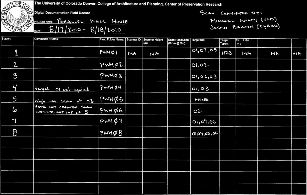
4 Procedures and Scanning Effort Details for McElmo Flume On Site Process: The University of Colorado Denver scanned 2 sites in the Canyons of the Ancients National Monument Parallel Wall House and Saddlehorn Hamlet using a Leica Scan Station 2 Scanner. Starting on August 17 th 2010 Mike Nulty and Justin Barton (CyArk) arrived on site at Parallel Wall house at approximately 11am and began scanning at the first location by 12pm. In total, eight different scan locations were acquired on site, and of those locations three consisted of 360 degree scans to acquire surrounding context of the surrounding area. The remaining five scans consisted of detailed window scans of the structure and other important features. In addition to scanning, eight panoramic images were also captured at each location to be used for photo texturing during post processing. Six HDS targets were used throughout the site as control points that would later tie all eight scan locations together. Two to four targets were acquired at each location. The final scan was started at about 12pm the next day ( ). The scan team packed up that afternoon to travel to the second site Saddlehorn Hamlet. The scan team arrived on site at Saddlehorn Hamlet at approximately 5:30pm on A scan was attempted that evening but rain and wind made it impossible to scan. Scanning was restarted the next morning at approximately 7am. In total, 5 different scan locations were used to record the two room structure and surrounding context. Five HDR, panoramic images were collected at each location. Eight HDS targets were used throughout the site as control points that were used to tie all five scan locations together. With so many targets collected we were able to use an automated process for registering all scan worlds together. The scan team finished up at about Noon that day ( ). Initial Post Processing: Later that year post processing of the two sites began. All panoramic images were processed and eventually applied to each scan location making the data look more photo realistic. All scan locations were registered together using a combination of target and feature registration with a Mean Absolute Error (MAE) of only.002 m. Deliverable Processing: Leica s Cyclone software was used to create scaled and ortho rectified views of the scan data. CloudWorx software was then used to bring this 2D scan data into AutoCAD. The scan data was then traced in AutoCAD to create a scaled and accurate drawing of the structures and surrounding context. These hardline drawings were then printed on Mylar. The final step was to use hand stippling and rendering to give the digitally created drawings a hand drawn finish and look. Final drawings included site plans, plans, elevations and sections. 4


5 Site Photos Parallel Wall House being scanned by Leica Scan Station 2 Field Notes: 5
6
7
8

9
McElmo Flume LIDAR Scanning Project Report
 McElmo Flume LIDAR Scanning Project Report CoPR Center of Preservation Research College of Architecture and Planning University of Colorado Denver 1512 Larimer Street, Suite 750, Denver, CO 80202 p 303.315.5871
Beacon Island Report / Notes
 Beacon Island Report / Notes Paul Bourke, ivec@uwa, 17 February 2014 During my 2013 and 2014 visits to Beacon Island four general digital asset categories were acquired, they were: high resolution panoramic
SpheroCam HDR. Image based lighting with. Capture light perfectly SPHERON VR. 0s 20s 40s 60s 80s 100s 120s. Spheron VR AG
 Image based lighting with SpheroCam HDR Capture light perfectly 0 60 120 180 240 300 360 0s 20s 40s 60s 80s 100s 120s SPHERON VR high dynamic range imaging Spheron VR AG u phone u internet Hauptstraße
A taste for landscapes
 A taste for landscapes NEPG workshop October 2012 Colin White 1 Main ingredients 1. Light 2. Composition 3. Kit 4. Post production 2 Light Hue, direction, dynamic range Time of day - around sunrise or
Z+F IMAGER 5016 / Laser Scanner
 Z+F IMAGER 5016 / Laser Scanner Reaching new levels The new Z+F IMAGER 5016 combines compact and lightweight design with state-of-the-art laser scanning technology - allowing the user to reach new levels.
WWII. Revisited. ipad & Tablet Ready! inside. BIM for. Quarry Management Changing the face. Data. Knowledge needed. Challenges and benefits
 inside Quarry Management Changing the face BIM for Construction Challenges and benefits Data Management Knowledge needed Vol. 2 Issue 2 WWII Revisited ipad & Tablet Ready! The Virtual Japanese American
istar Panoramas for HDS Point Clouds Hugh Anderson Illustrations, descriptions and technical specification are not binding and may change.
 istar Panoramas for HDS Point Clouds istar Panoramas for HDS Point Clouds Why use istar Panoramas for HDS Point Clouds Taking the Photographs Fitting the Panorama with ColourCloud Creating the Equirectangular
Present. Architecture
 Present Cary Photographic Artists Architecture A Mastering the Art of Photography Topic Developed by Sterling E. Stevens September 20, 2012 Note 1: All notes are on the final page Agenda Useful equipment
This talk is oriented toward artists.
 Hello, My name is Sébastien Lagarde, I am a graphics programmer at Unity and with my two artist co-workers Sébastien Lachambre and Cyril Jover, we have tried to setup an easy method to capture accurate
Time-Lapse Panoramas for the Egyptian Heritage
 Time-Lapse Panoramas for the Egyptian Heritage Mohammad NABIL Anas SAID CULTNAT, Bibliotheca Alexandrina While laser scanning and Photogrammetry has become commonly-used methods for recording historical
DUNKELD DIGITAL LANDSCAPE PHOTOGRAPHY
 DUNKELD DIGITAL LANDSCAPE PHOTOGRAPHY C O L I N P R I O R E X P L O R E D I S C O V E R I N S P I R E DUNKELD BIG TREE COUNTRY DIGITAL LANDSCAPE PHOTOGRAPHY Spend two days developing your skills with Colin
WORKFLOW GUIDE. Trimble TX8 3D Laser Scanner Camera and Nodal Ninja R1w/RD5 Bracket Kit
 WORKFLOW GUIDE Trimble TX8 3D Laser Scanner Camera and Nodal Ninja R1w/RD5 Bracket Kit Version 1.00 Revision A August 2014 1 Corporate Office Trimble Navigation Limited 935 Stewart Drive Sunnyvale, CA
Techniques 02: Working with Light All images Paul Hazell
 CDME2031/3031 Visual Effects digital Photography Techniques 02: Working with Light All images Paul Hazell Faking lighting in Photoshop See Steve Caplins How to cheat in Photoshop page 138 to 171 for fake
Proposed Kumototo Site 10 Wellington
 Proposed Kumototo Site 10 Wellington Visualisation Simulation Methodology - Buildmedia Limited Contents 1.0 Introduction 2.0 Process Methodology Kumototo Site 10 Visual Simulation 3.0 Conclusion 1.0 Introduction
COMPARISON OF GEOMETRIC AND RADIOMETRIC INFORMATION FROM PHOTOGRAMMETRY AND COLOR-ENRICHED LASER SCANNING
 COMPARISON OF GEOMETRIC AND RADIOMETRIC INFORMATION FROM PHOTOGRAMMETRY AND COLOR-ENRICHED LASER SCANNING Cornelis STAL, Philippe DE MAEYER, Marijke DE RYCK, Alain DE WULF, Rudi GOOSSENS, Timothy NUTTENS
Work Experience Pack. Prepared by LMP Architectural Consultants. LMP Architectural Consultants Work Experience Pack
 Prepared by 1 1.0 Exercise 1 Freehand Trace In this exercise you will learn the basics of using a traditional drawing board, technical pens and the set square. You will require the following materials
Movie 7. Merge to HDR Pro
 Movie 7 Merge to HDR Pro 1 Merge to HDR Pro When shooting photographs with the intention of using Merge to HDR Pro to merge them I suggest you choose an easy subject to shoot first and follow the advice
Produce stunning. Pro photographer Chris Humphreys guides you through HDR and how to create captivating natural-looking images
 Masterclass: In association with Produce stunning HDR images Pro photographer Chris Humphreys guides you through HDR and how to create captivating natural-looking images 8 digital photographer 45 masterclass4produce
UltraCam and UltraMap Towards All in One Solution by Photogrammetry
 Photogrammetric Week '11 Dieter Fritsch (Ed.) Wichmann/VDE Verlag, Belin & Offenbach, 2011 Wiechert, Gruber 33 UltraCam and UltraMap Towards All in One Solution by Photogrammetry ALEXANDER WIECHERT, MICHAEL
Designing new resources for visualizing archaeological sites is not a break
 Objective Designing new resources for visualizing archaeological sites is not a break with current or traditional archaeological techniques and practices, but an opportunity to engage and expand them.
BASIC PHOTOGRAPHY FALL 2017
 BASIC PHOTOGRAPHY FALL 2017 Instructor: Tina Doyle Office: Library B319 email: Tina.Doyle@angelo.edu Phone: (325)486-6079 Office Hours: Monday/Wednesday: 10:00 a.m. 11:00 a.m. and 5:00 6:00 p.m. Tuesday/Thursday:
OVERVIEW. Ruggedised: ip 64 rated FOV: 360 X 275. Small footprint. High resolution 50 megapixel panoramic image. 4 x pre-calibrated sensors
 OVERVIEW Designed for rapid 360º precision imaging, istar is a 360º panoramic camera that captures full spherical images and high resolution panoramic video streams, providing efficient visual documentation
LANDSCAPE PHOTOGRAPHY TECHNIQUES, COMPOSITION, AND PROCESSING
 LANDSCAPE PHOTOGRAPHY TECHNIQUES, COMPOSITION, AND PROCESSING Tom Price LANDSCAPE PHOTOGRAPHY TIPS AND TRICKS Wide angle lens desirable 16-18 mm good focal length for APC-C sensor Telephoto also produce
Heritage Scanning. ipad & Tablet Ready! inside. CONFERENCE REVIEWS SPAR-Europe & ELMF. SOFTWARE REVIEW EdgeWise Plant 2.0
 inside CONFERENCE REVIEWS SPAR-Europe & ELMF SOFTWARE REVIEW EdgeWise Plant 2.0 DISASTER RESPONSE Flood mapping, IPLER Vol. 2 Issue 1 Heritage Scanning ipad & Tablet Ready! Digitally Preserving the Icons
KEY WORDS: Animation, Architecture, Image Rectification, Multi-Media, Texture Mapping, Visualization
 AUTOMATED PROCESSING OF DIGITAL IMAGE DATA IN ARCHITECTURAL SURVEYING Günter Pomaska Prof. Dr.-Ing., Faculty of Architecture and Civil Engineering FH Bielefeld, University of Applied Sciences Artilleriestr.
Displayed with permission The American Surveyor November Copyright 2007 Cheves Media
 Scanning Deadwood Preserving cultural heritage sites is an important challenge. Ben Kacyra, founder of CyArk High Definition Network and the father of 3D laser scanning ot documenting an historic area
Real Estate Services Price Sheet Toll Free:
 Real Estate Services Price Sheet 972-771-1440 Toll Free: 1-866-428-2594 FULL SERVICE APPROACH Matrix Tours focus is to provide all the dynamic visual content needed to successfully market an agent s listings.
Blue Hour and HDR Tutorial by John Strung
 Blue Hour and HDR Tutorial by John Strung the Blue Hour is a wonderful time of night when photography can yield images of intense blue colours. Blue Hour is a bit of a misnomer for two reasons. There are
Realistic Visual Environment for Immersive Projection Display System
 Realistic Visual Environment for Immersive Projection Display System Hasup Lee Center for Education and Research of Symbiotic, Safe and Secure System Design Keio University Yokohama, Japan hasups@sdm.keio.ac.jp
AUTOMATED PROCESSING OF DIGITAL IMAGE DATA IN ARCHITECTURAL SURVEYING
 International Archives of Photogrammetry and Remote Sensing. Vol. XXXII, Part 5. Hakodate 1998 AUTOMATED PROCESSING OF DIGITAL IMAGE DATA IN ARCHITECTURAL SURVEYING Gunter Pomaska Prof. Dr.-lng., Faculty
Understanding f-stopsf
 Understanding f-stopsf When you buy a new DSLR there is a mass of technical information for you to get your head around. Here I will explain what you need to know in order to get an understanding of f-stops.
Drones for Telecommunications
 April 6, 2017 Drones for Telecommunications How AT&T uses drones to support and enhance its network Art Pregler AT&T UAS Program Director 2017 AT&T Intellectual Property. All rights reserved. AT&T, Globe
3D Scanning Services Information. With Hayles & Howe By K Lawrence CAD Technician
 3D Scanning Services Information 2017 With Hayles & Howe By K Lawrence CAD Technician 1 Summary Faro Laser Scanner Focus 3D X 130 HDR With the use of a 3D laser scanner you can capture any environment
What is Meant by Level of Accuracy? As a service provider who. By John M. Russo, AIA. room width = 10'-0' building length = 100'-0' x = 1/4"
 room width = 10'-0' x = 1/4" building length = 100'-0' x = 1/4" What is Meant by Level of Accuracy? As a service provider who documents buildings I often hear my clients say I need one quarter inch accuracy,
The upper rail is adjusted so that the gold ring is vertically in line with the axis of rotation as shown in the image below.
 Using PTGui with a Nikon 10.5mm Lens Preliminaries Before taking photographs, ensure that: The Nodal Ninja 3 MKII is fitted with the 45 n=8 detent ring. The lower rail is adjusted so that the centre of
ENVI Tutorial: Orthorectifying Aerial Photographs
 ENVI Tutorial: Orthorectifying Aerial Photographs Table of Contents OVERVIEW OF THIS TUTORIAL...2 ORTHORECTIFYING AERIAL PHOTOGRAPHS IN ENVI...2 Building the interior orientation...3 Building the exterior
Which equipment is necessary? How is the panorama created?
 Congratulations! By purchasing your Panorama-VR-System you have acquired a tool, which enables you - together with a digital or analog camera, a tripod and a personal computer - to generate high quality
Structure from Motion (SfM) Photogrammetry Field Methods Manual for Students
 Photogrammetry Field Methods Manual for Students") Structure from Motion (SfM) Photogrammetry Field Methods Manual for Students Written by Katherine Shervais (UNAVCO) Introduction to SfM for Field Education The purpose of the Analyzing High Resolution
Structure from Motion (SfM) Photogrammetry Field Methods Manual for Students Written by Katherine Shervais (UNAVCO) Introduction to SfM for Field Education The purpose of the Analyzing High Resolution
Introduction to 2-D Copy Work
 Introduction to 2-D Copy Work What is the purpose of creating digital copies of your analogue work? To use for digital editing To submit work electronically to professors or clients To share your work
Brief summary report of novel digital capture techniques
 Brief summary report of novel digital capture techniques Paul Bourke, ivec@uwa, February 2014 The following briefly summarizes and gives examples of the various forms of novel digital photography and video
Mobile Survey of Rail Track and Bed
 Mobile Survey of Rail Track and Bed DOT - FRA December 2, 2008 William J. Herr, MSEE, PE wherr@phnx-sci.com 760.471.5396 Pavement Profile Scanner (PPS) Fast Accurate Available Polygon Scanner Polygonal
HELICON FOCUS STAKING
 HELICON FOCUS STAKING Helicon Focus - a software program that creates one completely focused image from several partially focused images by combining the focused areas in contiguous images. The program
Panoramic imaging. Ixyzϕθλt. 45 degrees FOV (normal view)
") Camera projections Recall the plenoptic function: Panoramic imaging Ixyzϕθλt (,,,,,, ) At any point xyz,, in space, there is a full sphere of possible incidence directions ϕ, θ, covered by 0 ϕ 2π, 0 θ
Camera projections Recall the plenoptic function: Panoramic imaging Ixyzϕθλt (,,,,,, ) At any point xyz,, in space, there is a full sphere of possible incidence directions ϕ, θ, covered by 0 ϕ 2π, 0 θ
Unmanned Aerial Vehicle Data Acquisition for Damage Assessment in. Hurricane Events
 Unmanned Aerial Vehicle Data Acquisition for Damage Assessment in Hurricane Events Stuart M. Adams a Carol J. Friedland b and Marc L. Levitan c ABSTRACT This paper examines techniques for data collection
Recording The Incident. Forensic Science
 Recording The Incident Forensic Science After the crime scene has been managed and the initial assessment (recording the original situation and how it was discovered) is complete, the forensic photographers
Fireworks. Colin White 2016
 Fireworks Colin White 2016 Australia day is coming up, and photographers will feel an urge to have a go at photographing the fireworks. If this description fits you, then my experience from last year may
Almost all of the measurement process is automated. The images are processed and the coordinates extracted by the AutoMeasure command.
 The following report summarizes the results of the targetless 3-D measurement of a car hood. The hood was photographed and measured using Geodetic Services, Inc s (GSI) and a single projector setup (targetless
A New Capability for Crash Site Documentation
 A New Capability for Crash Site Documentation By Major Adam Cybanski, Directorate of Flight Safety, Ottawa Major Adam Cybanski is the officer responsible for helicopter investigation (DFS 2-4) at the Canadian
Landscape Photography
 Landscape Photography Francis J Pullen Photography 2015 Landscape photography requires a considered approach, and like fine wine or food, should not be rushed. You may even want scout out the desired location
Case Study. How we build reality. High Dynamic Range. Company Overview
 How we build reality Case Study High Dynamic Range Company Overview Z+F is one of the world s leading manufacturers in the field of non-contact laser measurement technology. Due to years of research, development
HIGH RESOLUTION COLOR IMAGERY FOR ORTHOMAPS AND REMOTE SENSING. Author: Peter Fricker Director Product Management Image Sensors
 HIGH RESOLUTION COLOR IMAGERY FOR ORTHOMAPS AND REMOTE SENSING Author: Peter Fricker Director Product Management Image Sensors Co-Author: Tauno Saks Product Manager Airborne Data Acquisition Leica Geosystems
Acquisition of Aerial Photographs and/or Satellite Imagery
 Acquisition of Aerial Photographs and/or Satellite Imagery Acquisition of Aerial Photographs and/or Imagery From time to time there is considerable interest in the purchase of special-purpose photography
How to combine images in Photoshop
 How to combine images in Photoshop In Photoshop, you can use multiple layers to combine images, but there are two other ways to create a single image from mulitple images. Create a panoramic image with
Navigation Aid System Setup and Operation Manual
 Navigation Aid System Setup and Operation Manual 016-0171-055 Revision G, 5/8/2012 Page 2 of 21 Change History Revision Date Description G 5/8/2012 Updated to Raven Marine Logo and new style F 11/23/10
Extract from NCTech Application Notes & Case Studies Download the complete booklet from nctechimaging.com/technotes
 Extract from NCTech Application Notes & Case Studies Download the complete booklet from nctechimaging.com/technotes [Application note - istar & HDR, multiple locations] Low Light Conditions Date: 17 December
THE SCOTTISH TEN PROJECT: COLLABORATIVE HERITAGE DOCUMENTATION
 THE SCOTTISH TEN PROJECT: COLLABORATIVE HERITAGE DOCUMENTATION L. Wilson a, *, A. Rawlinson b D.S. Mitchell a, H.C. McGregor a, R Parsons c a Historic Scotland, Longmore House, Salisbury Place, Edinburgh,
RAF DRAFT. Viewpoint 11: Taken from a road within Burlescombe, looking oking south-west towards the site.
 St. Mary s Church (Grade I listed) Viewpoint 11: Taken from a road within Burlescombe, looking oking south-west towards the site. RAF Approximate location of the site obscured by existing conifers FT Viewpoint
inphoto ID SLR Automatic ID photography With Canon SLR camera User Guide
 inphoto ID SLR Automatic ID photography With Canon SLR camera User Guide 2014 Akond company Phone/fax: +7(812)384-6430 Cell: +7(921)757-8319 e-mail: info@akond.net akondsales@gmail.com http://www.akond.net
Planning A Photography Trip. John Nixon, Master Photographer Fort Worth Camera Club Oct. 9, 2018
 Planning A Photography Trip John Nixon, Master Photographer Fort Worth Camera Club Oct. 9, 2018 Topics Determine location Research location Type of transportation Equipment Work the scene Back up images
Photography Masterclass. Flinders Ranges
 Photography Masterclass Flinders Ranges Join us for 6 nights at the edge of the Australian Outback to explore landscapes and lifestyles where the Flinders Ranges meet the dunes and desert. Ian Rolfe and
Aerial photography and Remote Sensing. Bikini Atoll, 2013 (60 years after nuclear bomb testing)
") Aerial photography and Remote Sensing Bikini Atoll, 2013 (60 years after nuclear bomb testing) Computers have linked mapping techniques under the umbrella term : Geomatics includes all the following spatial
Aerial photography and Remote Sensing Bikini Atoll, 2013 (60 years after nuclear bomb testing) Computers have linked mapping techniques under the umbrella term : Geomatics includes all the following spatial
MSB Imagery Program FAQ v1
 MSB Imagery Program FAQ v1 (F)requently (A)sked (Q)uestions 9/22/2016 This document is intended to answer commonly asked questions related to the MSB Recurring Aerial Imagery Program. Table of Contents
Leica - 3 rd Generation Airborne Digital Sensors Features / Benefits for Remote Sensing & Environmental Applications
 Leica - 3 rd Generation Airborne Digital Sensors Features / Benefits for Remote Sensing & Environmental Applications Arthur Rohrbach, Sensor Sales Dir Europe, Middle-East and Africa (EMEA) Luzern, Switzerland,
Acquisition of Aerial Photographs and/or Imagery
 Acquisition of Aerial Photographs and/or Imagery Acquisition of Aerial Photographs and/or Imagery From time to time there is considerable interest in the purchase of special-purpose photography contracted
Introduction to Panoramic photography. David R. Chung Linn Area Photography Club
 Introduction to Panoramic photography David R. Chung http://www.dchung.com Linn Area Photography Club 1. What is a panoramic photograph? 2. Why panoramas? 3. Techniques 4. In the field 5. In the digital
Advanced Near-Realistic 3D Lighting: Capturing, Creating, and Using Image-Based Lighting
 Advanced Near-Realistic 3D Lighting: Capturing, Creating, and Using Image-Based Lighting Christopher M Murray Autodesk Media & Entertainment DG4325 Intended for Autodesk 3ds Max 2012 and Autodesk Showcase
Pinhole Photography. Martin Henson Photography
 Over the last year or so I have been doing more and more pinhole photography than any other type. I have in my collection of cameras 35mm to 4x5 sheet film, the lens are among some of the best, a Zeiss
Appendix 8.2 Information to be Read in Conjunction with Visualisations
 Shepherds Rig Wind Farm EIA Report Appendix 8.2 Information to be Read in Conjunction with Visualisations Contents Contents i Introduction 1 Viewpoint Photography 1 Stitching of Panoramas and Post-Photographic
Remote Sensing in Archaeology. By: Aaron Osicki B.Sc. Anthropology, University of Calgary B.A. Archaeology, University of Calgary
 Remote Sensing in Archaeology By: Aaron Osicki B.Sc. Anthropology, University of Calgary B.A. Archaeology, University of Calgary What will be covered... Relevance of Remote Sensing in Archaeology Past
Topic 2 - A Closer Look At Exposure: ISO
 Getting more from your Camera Topic 2 - A Closer Look At Exposure: ISO Learning Outcomes In this lesson, we will revisit the concept of ISO and the role it plays in your photography and by the end of this
High Dynamic Range (HDR) photography is a combination of a specialized image capture technique and image processing.
 photography is a combination of a specialized image capture technique and image processing.") Introduction High Dynamic Range (HDR) photography is a combination of a specialized image capture technique and image processing. Photomatix Pro's HDR imaging processes combine several Low Dynamic Range
Introduction High Dynamic Range (HDR) photography is a combination of a specialized image capture technique and image processing. Photomatix Pro's HDR imaging processes combine several Low Dynamic Range
MULTISPECTRAL AGRICULTURAL ASSESSMENT. Normalized Difference Vegetation Index. Federal Robotics INSPECTION & DOCUMENTATION
 MULTISPECTRAL AGRICULTURAL ASSESSMENT Normalized Difference Vegetation Index INSPECTION & DOCUMENTATION Federal Robotics Clearwater Dr. Amherst, New York 14228 716-221-4181 Sales@FedRobot.com www.fedrobot.com
CONTROLLING METHODS AND CHALLENGES OF ROBOTIC ARM
 CONTROLLING METHODS AND CHALLENGES OF ROBOTIC ARM Aniket D. Kulkarni *1, Dr.Sayyad Ajij D. *2 *1(Student of E&C Department, MIT Aurangabad, India) *2(HOD of E&C department, MIT Aurangabad, India) aniket2212@gmail.com*1,
Cartogam Real-Time Portable Gamma-Ray Imaging System
 Features Complete tool for in situ cartography, saving time, cost and dose Real-time acquisition and immediate display Two dimensional gamma mapping and dose range Dose rate estimation of hot spots Excellent
Marmot & Little Sandy Dam Removal
 Marmot & Little Sandy Dam Removal Final Report August 2009 Bruce McCammon Photography 10691 NW Harding Ct. Portland, OR 97229 www.bpmphotography.com Contract Number AG-046W-P-07-0099 Contents Introduction...
Blarney Photography Club
 Beginner s Course 2017 8 Week Course Photography for Beginners / Improves course starts on Sep 28th 2017 from 7pm to 8pm in Scoil Mhuire Gan Smal (Secondary School) The course is intended to provide a
Digitizing Film Using the D850 and ES-2 Negative Digitizer
 JULY 23, 2018 INTERMEDIATE Digitizing Film Using the D850 and ES-2 Negative Digitizer The ES 2 can be used with both strip film and mounted slides. Digitizing film is the process of creating digital data
Expanding Your Creativity at Mono Lake October Instructor: Lewis Kemper Lee Vining, California
 Expanding Your Creativity at Mono Lake October 23-27 Instructor: Lewis Kemper Lee Vining, California Creativity is allowing yourself to make mistakes. Art is knowing which ones to keep. Scott Adams Mono
What Plans Do I Need for a Building Permit?
 What Plans Do I Need for a Building Permit? 6 CITY OF PORTLAND, OREGON - BUREAU OF DEVELOPMENT SERVICES 1900 SW 4th Avenue, Por tland, Oregon 97201 503-823-7300 www.portlandoregon.gov/bds This brochure
inphoto ID PS Automatic ID photography With Canon PowerShot camera User Guide
 inphoto ID PS Automatic ID photography With Canon PowerShot camera User Guide 2018 Akond company Phone/fax: +7(812)384-6430 Cell: +7(921)757-8319 e-mail: info@akond.net akondsales@gmail.com http://www.akond.net
Luxury accommodation at the Hilton Dunkeld House hotel with dinner in the Garden Restaurant. PRICE 599
 PHOTOGRAPHY WORKSHOP DUNKELD DUNKELD TRIP OVERVIEW DATES 22 24 April 2016 30 Sep 2 Oct 2016 DURATION 2 nights LOCATION Dunkeld STARTS/FINISHES Dunkeld COMFORT TRIP GRADING Classic Easy PRICE 599 (Partners
SURVEY DRAWINGS CONSISTENCY: THE USE OF MATERIAL-BASED LAYERING
 SURVEY DRAWINGS CONSISTENCY: THE USE OF MATERIAL-BASED LAYERING SYSTEMS IN COMPUTER AIDED DESIGN AND DRAFTING Saskia BOOM 1, Pierangelo CACCIOTTI 1, Maud DE VOGHT 1, Luca VISCONTI 1 1 Raymond Lemaire International
Expanding Your Creativity at Mono Lake October 8-12, 2018 Instructor: Lewis Kemper Lee Vining, California
 Expanding Your Creativity at Mono Lake October 8-12, 2018 Instructor: Lewis Kemper Lee Vining, California Creativity is allowing yourself to make mistakes. Art is knowing which ones to keep. Scott Adams
11/25/2009 CHAPTER THREE INTRODUCTION INTRODUCTION (CONT D) THE AERIAL CAMERA: LENS PHOTOGRAPHIC SENSORS
 THE AERIAL CAMERA: LENS PHOTOGRAPHIC SENSORS") INTRODUCTION CHAPTER THREE IC SENSORS Photography means to write with light Today s meaning is often expanded to include radiation just outside the visible spectrum, i. e. ultraviolet and near infrared
INTRODUCTION CHAPTER THREE IC SENSORS Photography means to write with light Today s meaning is often expanded to include radiation just outside the visible spectrum, i. e. ultraviolet and near infrared
Use of digital aerial camera images to detect damage to an expressway following an earthquake
 Use of digital aerial camera images to detect damage to an expressway following an earthquake Yoshihisa Maruyama & Fumio Yamazaki Department of Urban Environment Systems, Chiba University, Chiba, Japan.
Photo 204: Creative Photographic Techniques SPECIAL TECHNIQUES & EFFECTS: HDRI PHOTOGRAPHY
 Photo 204: Creative Photographic Techniques SPECIAL TECHNIQUES & EFFECTS: HDRI PHOTOGRAPHY Course Outline & Syllabus T his course is designed for intermediate to advanced photography students. It will
High Dynamic Range Photography
 JUNE 13, 2018 ADVANCED High Dynamic Range Photography Featuring TONY SWEET Tony Sweet D3, AF-S NIKKOR 14-24mm f/2.8g ED. f/22, ISO 200, aperture priority, Matrix metering. Basically there are two reasons
Jeff Morgan Tel: Through My Lens. ~ Available as 1 hour, 2 hour or 3 hour talk/discussion ~
 Through My Lens ~ Available as 1 hour, 2 hour or 3 hour talk/discussion ~ In this presentation you will see a selection of the best digital images that I have captured in the last 10 years. I will discuss
Photo Walks: Green Back Yard to Old Fletton
 Photo Walks: Green Back Yard to Old Fletton Along the Outskirts is a project by artist Marc Atkinson to reflect on the landscape along the peripheries of the City of Peterborough. The project will culminate
Creating a Panorama Photograph Using Photoshop Elements
 Creating a Panorama Photograph Using Photoshop Elements Following are guidelines when shooting photographs for a panorama. Overlap images sufficiently -- Images should overlap approximately 15% to 40%.
Leica ADS80 - Digital Airborne Imaging Solution NAIP, Salt Lake City 4 December 2008
 Luzern, Switzerland, acquired at 5 cm GSD, 2008. Leica ADS80 - Digital Airborne Imaging Solution NAIP, Salt Lake City 4 December 2008 Shawn Slade, Doug Flint and Ruedi Wagner Leica Geosystems AG, Airborne
Architecture and Colour
 Architecture and Colour Copies of architectural drawings and maps of the Bridgewater Canal Selection of Watercolour pencils Pots of water This activity is about shape and colour, linking in the shapes
Suggestions. landscapes. for photographing. For nature photographer, For landscape photographers, Copyright FLAAR Photo Archive 2012
 Copyright FLAAR Photo Archive 2012 Suggestions for photographing landscapes For nature photographer, For landscape photographers, For botanists, zoologists and biologists who study eco-systems Introduction
EinScan-SE. Desktop 3D Scanner. User Manual
 EinScan-SE Desktop 3D Scanner User Manual Catalog 1. 2. 3. 4. 5. 6. 7. 8. 1.1. 1.2. 1.3. 1.1. 1.2. 1.1. 1.2. 1.3. 1.1. 1.2. Device List and Specification... 2 Device List... 3 Specification Parameter...
How I did it by Chris Axe. Special thanks to Kim Walker
 How I did it by Chris Axe Special thanks to Kim Walker Story of this image This photo was taken in Garrapata State Park at the very first gate as you head south. It took about 15 minutes to figure out
High resolution terrestrial laser scanning for tunnel deformation measurements
 High resolution terrestrial laser scanning for tunnel deformation measurements Timothy NUTTENS, Alain DE WULF, Lander BRAL, Bart DE WIT, Leen CARLIER, Marijke DE RYCK, Cornelis STAL Ghent University, Department
Acadia National Park Autumn Adventure
 Acadia National Park Autumn Adventure 6 Day Photography Workshop October 9 - October 14, 2011 Mount Desert Island, ME Acadia National Park - Autumn Adventure Landscape Photography Workshop - Fall 2010
OUR INDUSTRIAL LEGACY WHAT ARE WE LEAVING OUR CHILDREN REAAA Roadshow Taupo, August 2016 Young presenter s competition
 OUR INDUSTRIAL LEGACY WHAT ARE WE LEAVING OUR CHILDREN Preserving the country s aerial photography archive for future generations Abstract For over eighty years, aerial photography has captured the changing
Sunrise and Sunset Photography
 Sunrise and Sunset Photography Ben Weeks, November 2010 Sunrise. It happens every day, 365 days a year, yet the vast majority of these solar ascents will go by completely unnoticed by most of us. At the
FEATURED PORTFOLIO CHRIS FRIEL
 FEATURED PORTFOLIO CHRIS FRIEL A colourblind former painter from Britain, Chris Friel s camera has replaced his brush and the landscape is now his canvas. Chris painterly images were a hit on Flickr and