Collection and application of 2D and 3D panoramic imagery
|
|
|
- Colleen Shields
- 5 years ago
- Views:
Transcription
1 Collection and application of 2D and 3D panoramic imagery CycloMedia Technology Bart Beers Stuttgart - September 9, 2011 Collection and application of 2D and 3D panoramic imagery Introduction CycloMedia 2D panoramic images Recording principle, measuring principle, accuracy and applications Adding 3D to panoramic images 3D advantages and applications.
 High resolution (4800 pixels hor., 0,075 res.")
 Selectable interval between recordings, std.")

2 Large scale and systematic visualizations Street level Databases with Cycloramas (digital, spherical, panoramic images) High resolution (4800 pixels hor., 0,075 res.) Well defined internal image geometry, no parallaxes Good georeference (10 cm) and orientation (0,1 ) Selectable interval between recordings, std. 5 m Up to 80 km/h recording speed at 5 m interval World-wide patented recording technology Systematic and complete recording of cities, regions and complete countries Delivery through web hosting or local installation. Cycloramas Present Recording Principle


3 Cycloramas Present Recording Principle The only practical way to obtain photogrammetrically correct panoramic images Cycloramas Present Recording Principle


4 Cycloramas Present Recording Principle Camera 1 IMU Display, mouse, keyboard Camera 2 GPS-Antenna TMU Camera Control, POS, PC, cooling 2x DMI Cycloramas Measuring principle


5 Comparison with alternatives Large scale and systematic Up-to-date? Precision recording location? Image geometry? Cycloramas Measuring Principle An ordinary Cyclorama is a flat image Every pixel represents a spatial direction with a known orientation from a known recording position To determine the coordinates of an object point at least two Cycloramas are required.


6 Cycloramas Measuring Principle (intersection) Top view Spatial direction (X, Y, Z) 1 (X, Y, Z) 2 Cycloramas Measurements with GlobeSpotter


7 Applications - 3D Texturing with Cycloramas Applications Determining location and height of objects Determining location and height of noise barriers, traffic barriers, street furniture etc.


8 Applications - Inventory of traffic signs Applications 2D Projection


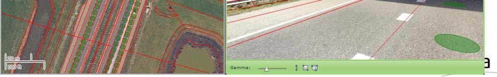


9 Applications 3D Projection Applications 2D Projection


10 Applications 2D Projection That s why: 3D Depth Cycloramas A 3D Depth Cyclorama isn t a flat image Every pixel also contains the distance to an object point Every pixel thus represents the 3D coordinates of an object point To determine the coordinates of an object point only one Cyclorama is required 2D data can be draped in the 3D Depth Cyclorama.
11 3D Depth Cycloramas - Principle R G B D Q 3D Depth Cycloramas At present produced using LiDAR point clouds Point cloud accuracy issues wrt. Cycloramas Density Positioning.


12

13


14


15 Synergy: Cycloramas + LiDAR Cycloramas serve for interpretation and photogrammetric quality LiDAR point clouds serve for 3D information are being verified and if necessary corrected from Cyclorama geometry. Know where you make a measurement!

16 3D Depth Cycloramas - Applications Single image measurement of points, lines and areas 3D Depth Cycloramas - Applications Single image measurement of points, lines and areas


17 3D Depth Cycloramas - Applications Single image measurement of points, lines and areas 3D Depth Cycloramas - Applications Stereo presentation: gives better interpretation (and measuring accuracy)
")

18 3D Depth Cycloramas - Applications Overlay of 2D and 3D plans with occlusion (hidden line/surface removal) 3D Depth Cycloramas - Applications Overlay of 2D and 3D plans with occlusion (hidden line/surface removal)
19 3D Depth Cycloramas - Advantages Simpler measurement and navigation Possibility to present in stereo Overlay of 2D and 3D plans with occlusion Through which: precise 3D Modelling easy cut out of textures verification of 2D and 3D plans quick and realistic visualization of plans. Thank you for your attention
Interactive Navigation Services through Value-added CycloMedia Panoramic Images
 Interactive Navigation Services through Value-added CycloMedia Panoramic Images Edward Verbree; Siyka Zlatanova Delft University of Technology OTB Research Institute Section GIS Technology Jaffalaan 9
UltraCam and UltraMap Towards All in One Solution by Photogrammetry
 Photogrammetric Week '11 Dieter Fritsch (Ed.) Wichmann/VDE Verlag, Belin & Offenbach, 2011 Wiechert, Gruber 33 UltraCam and UltraMap Towards All in One Solution by Photogrammetry ALEXANDER WIECHERT, MICHAEL
Update on UltraCam and UltraMap technology
 Update on UltraCam and UltraMap technology Alexander Wiechert, Michael Gruber Anzengrubergasse 8/4, 8010 Graz, Austria {alexander.wiechert, michael.gruber}@vexcel-imaging.com Stuttgart, September 2017
HIGH RESOLUTION COLOR IMAGERY FOR ORTHOMAPS AND REMOTE SENSING. Author: Peter Fricker Director Product Management Image Sensors
 HIGH RESOLUTION COLOR IMAGERY FOR ORTHOMAPS AND REMOTE SENSING Author: Peter Fricker Director Product Management Image Sensors Co-Author: Tauno Saks Product Manager Airborne Data Acquisition Leica Geosystems
Chapter 3 Data Acquisition in an Urban Environment
 Chapter 3 Data Acquisition in an Urban Environment - One fundamental issue : cost of data 5-10 times of HW, SW, org ware, staff training, maintenance - Another issue : different kinds of data alphanumeric
Lecture 19: Depth Cameras. Kayvon Fatahalian CMU : Graphics and Imaging Architectures (Fall 2011)
") Lecture 19: Depth Cameras Kayvon Fatahalian CMU 15-869: Graphics and Imaging Architectures (Fall 2011) Continuing theme: computational photography Cheap cameras capture light, extensive processing produces
Lecture 19: Depth Cameras Kayvon Fatahalian CMU 15-869: Graphics and Imaging Architectures (Fall 2011) Continuing theme: computational photography Cheap cameras capture light, extensive processing produces
GEO 428: DEMs from GPS, Imagery, & Lidar Tuesday, September 11
 GEO 428: DEMs from GPS, Imagery, & Lidar Tuesday, September 11 Global Positioning Systems GPS is a technology that provides Location coordinates Elevation For any location with a decent view of the sky
Lecture 18: Light field cameras. (plenoptic cameras) Visual Computing Systems CMU , Fall 2013
 Visual Computing Systems CMU , Fall 2013") Lecture 18: Light field cameras (plenoptic cameras) Visual Computing Systems Continuing theme: computational photography Cameras capture light, then extensive processing produces the desired image Today:
Lecture 18: Light field cameras (plenoptic cameras) Visual Computing Systems Continuing theme: computational photography Cameras capture light, then extensive processing produces the desired image Today:
Lecture 7. Leica ADS 80 Camera System and Imagery. Ontario ADS 80 FRI Imagery. NRMT 2270, Photogrammetry/Remote Sensing
 NRMT 2270, Photogrammetry/Remote Sensing Lecture 7 Leica ADS 80 Camera System and Imagery. Ontario ADS 80 FRI Imagery. Tomislav Sapic GIS Technologist Faculty of Natural Resources Management Lakehead University
Technical Notes LAND MAPPING APPLICATIONS. Leading the way with increased reliability.
 LAND MAPPING APPLICATIONS Technical Notes Leading the way with increased reliability. Industry-leading post-processing software designed to maximize the accuracy potential of your POS LV (Position and
In-Vivo IMAGING SYSTEMS. A complete line of high resolution optical & X-ray systems for pre-clinical imaging
 In-Vivo IMAGING SYSTEMS A complete line of high resolution optical & X-ray systems for pre-clinical imaging In-Vivo Imaging Systems Carestream is a strong, successful, multi-billion dollar, international
23270: AUGMENTED REALITY FOR NAVIGATION AND INFORMATIONAL ADAS. Sergii Bykov Technical Lead Machine Learning 12 Oct 2017
 23270: AUGMENTED REALITY FOR NAVIGATION AND INFORMATIONAL ADAS Sergii Bykov Technical Lead Machine Learning 12 Oct 2017 Product Vision Company Introduction Apostera GmbH with headquarter in Munich, was
Relief Displacement of Vertical Features
 G 210 Lab. Relief Displacement of Vertical Features An increase in the elevation of a feature causes its position on the photograph to be displaced radially outward from the principle point. Hence, when
Lesson 4: Photogrammetry
 This work by the National Information Security and Geospatial Technologies Consortium (NISGTC), and except where otherwise Development was funded by the Department of Labor (DOL) Trade Adjustment Assistance
Hybrid measurement techniques used to a study of historic cast iron suspension bridge
 IOP Conference Series: Materials Science and Engineering PAPER OPEN ACCESS Hybrid measurement techniques used to a study of historic cast iron suspension bridge To cite this article: Wojciech Anigacz et
Automotive Needs and Expectations towards Next Generation Driving Simulation
 Automotive Needs and Expectations towards Next Generation Driving Simulation Dr. Hans-Peter Schöner - Insight fromoutside -Consulting - Senior Automotive Expert, Driving Simulation Association September
PHOTOGRAMMETRIC RESECTION DIFFERENCES BASED ON LABORATORY vs. OPERATIONAL CALIBRATIONS
 PHOTOGRAMMETRIC RESECTION DIFFERENCES BASED ON LABORATORY vs. OPERATIONAL CALIBRATIONS Dean C. MERCHANT Topo Photo Inc. Columbus, Ohio USA merchant.2@osu.edu KEY WORDS: Photogrammetry, Calibration, GPS,
CHARACTERISTICS OF REMOTELY SENSED IMAGERY. Spatial Resolution
 CHARACTERISTICS OF REMOTELY SENSED IMAGERY Spatial Resolution There are a number of ways in which images can differ. One set of important differences relate to the various resolutions that images express.
Sample Copy. Not For Distribution.
 Photogrammetry, GIS & Remote Sensing Quick Reference Book i EDUCREATION PUBLISHING Shubham Vihar, Mangla, Bilaspur, Chhattisgarh - 495001 Website: www.educreation.in Copyright, 2017, S.S. Manugula, V.
CSI: Rombalds Moor Photogrammetry Photography
 Photogrammetry Photography Photogrammetry Training 26 th March 10:00 Welcome Presentation image capture Practice 12:30 13:15 Lunch More practice 16:00 (ish) Finish or earlier What is photogrammetry 'photo'
VisionMap Sensors and Processing Roadmap
 Vilan, Gozes 51 VisionMap Sensors and Processing Roadmap YARON VILAN, ADI GOZES, Tel-Aviv ABSTRACT The A3 is a family of digital aerial mapping cameras and photogrammetric processing systems, which is
Combining Technologies: LiDaR, High Resolution Digital Images, Infrared Thermography and Geographic Information Systems
 : LiDaR, High Resolution Digital Images, Infrared Thermography and Geographic Information Systems Presented by: Eldris Ferrer, Ms E, GIS Analyst and Remote Sensing Specialist, CSA Group Alexis Ocasio,
EXAMPLES OF TOPOGRAPHIC MAPS PRODUCED FROM SPACE AND ACHIEVED ACCURACY CARAVAN Workshop on Mapping from Space, Phnom Penh, June 2000
 EXAMPLES OF TOPOGRAPHIC MAPS PRODUCED FROM SPACE AND ACHIEVED ACCURACY CARAVAN Workshop on Mapping from Space, Phnom Penh, June 2000 Jacobsen, Karsten University of Hannover Email: karsten@ipi.uni-hannover.de
Technical Notes FOR MARINE MAPPING APPLICATIONS. Leading the way with increased reliability.
 FOR MARINE MAPPING APPLICATIONS Technical Notes Leading the way with increased reliability. Industry-leading post-processing software designed to maximize the accuracy potential of your POS MV (Position
EnsoMOSAIC Aerial mapping tools
 EnsoMOSAIC Aerial mapping tools Jakarta and Kuala Lumpur, 2013 Contents MosaicMill MM Application examples Software introduction System introduction Rikola HS sensor UAV platform examples SW Syst HS UAV
Geometry of Aerial Photographs
 Geometry of Aerial Photographs Aerial Cameras Aerial cameras must be (details in lectures): Geometrically stable Have fast and efficient shutters Have high geometric and optical quality lenses They can
THE USE OF PANORAMIC IMAGES FOR 3-D ARCHAEOLOGICAL SURVEY
 THE USE OF PANORAMIC IMAGES FOR 3-D ARCHAEOLOGICAL SURVEY Henrik Haggrén a, *, Hanne Junnilainen a, Jaakko Järvinen a, Terhi Nuutinen a, Mika Lavento b, Mika Huotari b a Institute of Photogrammetry and
Mobile Survey of Rail Track and Bed
 Mobile Survey of Rail Track and Bed DOT - FRA December 2, 2008 William J. Herr, MSEE, PE wherr@phnx-sci.com 760.471.5396 Pavement Profile Scanner (PPS) Fast Accurate Available Polygon Scanner Polygonal
Omni-Directional Catadioptric Acquisition System
 Technical Disclosure Commons Defensive Publications Series December 18, 2017 Omni-Directional Catadioptric Acquisition System Andreas Nowatzyk Andrew I. Russell Follow this and additional works at: http://www.tdcommons.org/dpubs_series
RADIOMETRIC AND GEOMETRIC CHARACTERISTICS OF PLEIADES IMAGES
 RADIOMETRIC AND GEOMETRIC CHARACTERISTICS OF PLEIADES IMAGES K. Jacobsen a, H. Topan b, A.Cam b, M. Özendi b, M. Oruc b a Leibniz University Hannover, Institute of Photogrammetry and Geoinformation, Germany;
TESTFIELD TRENTO: GEOMETRIC EVALUATION OF VERY HIGH RESOLUTION SATELLITE IMAGERY
 TESTFIELD TRENTO: GEOMETRIC EVALUATION OF VERY HIGH RESOLUTION SATELLITE IMAGERY G. AGUGIAROa, D. POLIb, F. REMONDINOa, 3DOM, 3D Optical Metrology Unit Bruno Kessler Foundation, Trento, Italy a b Vermessung
UAV Technologies for 3D Mapping. Rolf Schaeppi Director Geospatial Solutions APAC / India
 UAV Technologies for 3D Mapping Rolf Schaeppi Director Geospatial Solutions APAC / India Some main application areas? Market situation Analyst statements billion dollars 7,3 defense market 2,5 civil market
Visione per il veicolo Paolo Medici 2017/ Visual Perception
 Visione per il veicolo Paolo Medici 2017/2018 02 Visual Perception Today Sensor Suite for Autonomous Vehicle ADAS Hardware for ADAS Sensor Suite Which sensor do you know? Which sensor suite for Which algorithms
Module 3 Introduction to GIS. Lecture 8 GIS data acquisition
 Module 3 Introduction to GIS Lecture 8 GIS data acquisition GIS workflow Data acquisition (geospatial data input) GPS Remote sensing (satellites, UAV s) LiDAR Digitized maps Attribute Data Management Data
Improving Airport Planning & Development and Operations & Maintenance via Skyline 3D Software
 Improving Airport Planning & Development and Operations & Maintenance via Skyline 3D Software By David Tamir, February 2014 Skyline Software Systems has pioneered web-enabled 3D information mapping and
Towertrack 2 Optical Verification System
 User Manual Edition: 002 Date: 15-Sep-15 Status: Released Issue DOCUMENT CHARACTERISTICS General User Manual Edition: 002 Edition Date: 15-September-2015 Status: Released Issue Keywords: Towertrack, Optical,
CONTENTS INTRODUCTION ACTIVATING VCA LICENSE CONFIGURATION...
 VCA VCA Installation and Configuration manual 2 Contents CONTENTS... 2 1 INTRODUCTION... 3 2 ACTIVATING VCA LICENSE... 6 3 CONFIGURATION... 10 3.1 VCA... 10 3.1.1 Camera Parameters... 11 3.1.2 VCA Parameters...
APPLICATIONS AND LESSONS LEARNED WITH AIRBORNE MULTISPECTRAL IMAGING
 APPLICATIONS AND LESSONS LEARNED WITH AIRBORNE MULTISPECTRAL IMAGING James M. Ellis and Hugh S. Dodd The MapFactory and HJW Walnut Creek and Oakland, California, U.S.A. ABSTRACT Airborne digital frame
VERIFICATION OF POTENCY OF AERIAL DIGITAL OBLIQUE CAMERAS FOR AERIAL PHOTOGRAMMETRY IN JAPAN
 VERIFICATION OF POTENCY OF AERIAL DIGITAL OBLIQUE CAMERAS FOR AERIAL PHOTOGRAMMETRY IN JAPAN Ryuji. Nakada a, *, Masanori. Takigawa a, Tomowo. Ohga a, Noritsuna. Fujii a a Asia Air Survey Co. Ltd., Kawasaki
DEM Generation Using a Digital Large Format Frame Camera
 DEM Generation Using a Digital Large Format Frame Camera Joachim Höhle Abstract Progress in automated photogrammetric DEM generation is presented. Starting from the procedures and the performance parameters
Invited talk IET-Renault Workshop Autonomous Vehicles: From theory to full scale applications Novotel Paris Les Halles, June 18 th 2015
 Risk assessment & Decision-making for safe Vehicle Navigation under Uncertainty Christian LAUGIER, First class Research Director at Inria http://emotion.inrialpes.fr/laugier Contributions from Mathias
DALE KELLER, P.E. ASSHTO COD JUNE 14, 2018 NEVADA DOT
 Interactive Visualization DALE KELLER, P.E. ASSHTO COD JUNE 14, 2018 NEVADA DOT 1 Interactive Visualization AII Overview The AASHTO Innovation Initiative (AII) advances innovation from the grassroots up:
Automated GIS data collection and update
 Walter 267 Automated GIS data collection and update VOLKER WALTER, S tuttgart ABSTRACT This paper examines data from different sensors regarding their potential for an automatic change detection approach.
Strategic City Wide Mapping of Underground Assets using Ground Penetrating Radar. Mark Bell
 Strategic City Wide Mapping of Underground Assets using Ground Penetrating Radar Mark Bell XXV International Federation of Surveyors Congress, Kuala Lumpur, Malaysia, 16 21 June 2014 TOPICS GPR background
A model for new data - Using air borne traffic flow measurement for traffic forecast Reinhart Kühne (1 ; Martin Ruhé (1 ; Eileen Hipp (2
 A model for new data - Using air borne traffic flow measurement for traffic forecast Reinhart Kühne (1 ; Martin Ruhé (1 ; Eileen Hipp (2 1) German Aerospace Center (DLR), Transportation Studies; Rutherfordstr.
DLR Project ADVISE-PRO Advanced Visual System for Situation Awareness Enhancement Prototype Introduction The Project ADVISE-PRO
 DLR Project ADVISE-PRO Advanced Visual System for Situation Awareness Enhancement Prototype Dr. Bernd Korn DLR, Institute of Flight Guidance Lilienthalplatz 7 38108 Braunschweig Bernd.Korn@dlr.de phone
Flood modelling and management. Glasgow University. 8 September Paul Shaw - GeoVision
 Flood modelling and management Glasgow University 8 September 2004 Paul Shaw - GeoVision How important are heights in flood modelling? Comparison of data collection technologies GPS - Global Positioning
Aerial photography: Principles. Frame capture sensors: Analog film and digital cameras
 Aerial photography: Principles Frame capture sensors: Analog film and digital cameras Overview Introduction Frame vs scanning sensors Cameras (film and digital) Photogrammetry Orthophotos Air photos are
Duplicate Layer 1 by dragging it and dropping it on top of the New Layer icon in the Layer s Palette. You should now have two layers rename the top la
 50 Face Project For this project, you are going to put your face on a coin. The object is to make it look as real as possible. Though you will probably be able to tell your project was computer generated,
VisionMap A3 Edge A Single Camera for Multiple Solutions
 Photogrammetric Week '15 Dieter Fritsch (Ed.) Wichmann/VDE Verlag, Belin & Offenbach, 2015 Raizman, Gozes 57 VisionMap A3 Edge A Single Camera for Multiple Solutions Yuri Raizman, Adi Gozes, Tel-Aviv ABSTRACT
A New Capability for Crash Site Documentation
 A New Capability for Crash Site Documentation By Major Adam Cybanski, Directorate of Flight Safety, Ottawa Major Adam Cybanski is the officer responsible for helicopter investigation (DFS 2-4) at the Canadian
Geo-Located Content in Virtual and Augmented Reality
 Technical Disclosure Commons Defensive Publications Series October 02, 2017 Geo-Located Content in Virtual and Augmented Reality Thomas Anglaret Follow this and additional works at: http://www.tdcommons.org/dpubs_series
Sampling the World in 3D by Airborne LIDAR Assessing the Information Content of LIDAR Point Clouds
 Sampling the World in 3D by Airborne LIDAR Assessing the Information Content of LIDAR Point Clouds PhoWo 2013 September 11 th, 2013 Stuttgart, Germany Andreas Ullrich RIEGL LMS GmbH sequential data acquisition
Some Enhancement in Processing Aerial Videography Data for 3D Corridor Mapping
 Some Enhancement in Processing Aerial Videography Data for 3D Corridor Mapping Catur Aries ROKHMANA, Indonesia Key words: 3D corridor mapping, aerial videography, point-matching, sub-pixel enhancement,
BlopHome Help. How to get started. 1 of 5. If you are not logged in blophome
 How to get started New If you are not logged in blophome Open 1 of 5 My site How to get started New If you are logged in blophome Open 1 of 5 My site How to get started 2 of 5 With one click move and modify
Advanced Methods to Identify Asphalt Pavement Delamination (R06D) Ground Penetrating Radar (GPR) Caltrans
 Ground Penetrating Radar (GPR) Caltrans") Advanced Methods to Identify Asphalt Pavement Delamination (R06D) Ground Penetrating Radar (GPR) Caltrans William Owen Peer Exchange August 1-3, 2018 Introduction How We Got Here Strategic Highway Research
Advanced Methods to Identify Asphalt Pavement Delamination (R06D) Ground Penetrating Radar (GPR) Caltrans William Owen Peer Exchange August 1-3, 2018 Introduction How We Got Here Strategic Highway Research
Video Registration: Key Challenges. Richard Szeliski Microsoft Research
 Video Registration: Key Challenges Richard Szeliski Microsoft Research 1. 2. 3. 4. 5. 6. 7. 8. 9. 10. Key Challenges 1. Mosaics and panoramas 2. Object-based based segmentation (MPEG-4) 3. Engineering
An Introduction to Geomatics. Prepared by: Dr. Maher A. El-Hallaq خاص بطلبة مساق مقدمة في علم. Associate Professor of Surveying IUG
 An Introduction to Geomatics خاص بطلبة مساق مقدمة في علم الجيوماتكس Prepared by: Dr. Maher A. El-Hallaq Associate Professor of Surveying IUG 1 Airborne Imagery Dr. Maher A. El-Hallaq Associate Professor
Vexcel Imaging GmbH Innovating in Photogrammetry: UltraCamXp, UltraCamLp and UltraMap
 Photogrammetric Week '09 Dieter Fritsch (Ed.) Wichmann Verlag, Heidelberg, 2009 Wiechert, Gruber 27 Vexcel Imaging GmbH Innovating in Photogrammetry: UltraCamXp, UltraCamLp and UltraMap ALEXANDER WIECHERT,
Chapter 4 DGPS REQUIREMENTS AND EQUIPMENT SELECTION
 Chapter 4 DGPS REQUIREMENTS AND EQUIPMENT SELECTION 4.1 INTRODUCTION As discussed in the previous chapters, accurate determination of aircraft position is a strong requirement in several flight test applications
Managing and Monitoring Intertidal Oyster Reefs with Remote Sensing in Coastal South Carolina
 Managing and Monitoring Intertidal Oyster Reefs with Remote Sensing in Coastal South Carolina A cooperative effort between: Coastal Services Center South Carolina Department of Natural Resources City of
Phase One ixu-rs1000 Accuracy Assessment Report Yu. Raizman, PhaseOne.Industrial, Israel
 17 th International Scientific and Technical Conference FROM IMAGERY TO DIGITAL REALITY: ERS & Photogrammetry Phase One ixu-rs1000 Accuracy Assessment Report Yu. Raizman, PhaseOne.Industrial, Israel 1.
Roadside Range Sensors for Intersection Decision Support
 Roadside Range Sensors for Intersection Decision Support Arvind Menon, Alec Gorjestani, Craig Shankwitz and Max Donath, Member, IEEE Abstract The Intelligent Transportation Institute at the University
Yamamoto, Yuta, Jeong, Jong-Hyeok Author(s) aka.
 aka.") Kochi University of Technology Aca Establishing Spatial Database for Title with GPS Digital Camera Yamamoto, Yuta, Jeong, Jong-Hyeok Author(s) aka Society for Social Management Sys Citation ournal, 3(1)
Kochi University of Technology Aca Establishing Spatial Database for Title with GPS Digital Camera Yamamoto, Yuta, Jeong, Jong-Hyeok Author(s) aka Society for Social Management Sys Citation ournal, 3(1)
DEMS BASED ON SPACE IMAGES VERSUS SRTM HEIGHT MODELS. Karsten Jacobsen. University of Hannover, Germany
 DEMS BASED ON SPACE IMAGES VERSUS SRTM HEIGHT MODELS Karsten Jacobsen University of Hannover, Germany jacobsen@ipi.uni-hannover.de Key words: DEM, space images, SRTM InSAR, quality assessment ABSTRACT
DEM GENERATION WITH WORLDVIEW-2 IMAGES
 DEM GENERATION WITH WORLDVIEW-2 IMAGES G. Büyüksalih a, I. Baz a, M. Alkan b, K. Jacobsen c a BIMTAS, Istanbul, Turkey - (gbuyuksalih, ibaz-imp)@yahoo.com b Zonguldak Karaelmas University, Zonguldak, Turkey
September CoroCAM 6D. Camera Operation Training. Copyright 2012
 CoroCAM 6D Camera Operation Training September 2012 CoroCAM 6D Body Rubber cover on SD Card slot & USB port Lens Cap retention loop Charging port, video & audio output, audio input Laser pointer CoroCAM
Realistic Visual Environment for Immersive Projection Display System
 Realistic Visual Environment for Immersive Projection Display System Hasup Lee Center for Education and Research of Symbiotic, Safe and Secure System Design Keio University Yokohama, Japan hasups@sdm.keio.ac.jp
CSE 190: Virtual Reality Technologies LECTURE #7: VR DISPLAYS
 CSE 190: Virtual Reality Technologies LECTURE #7: VR DISPLAYS Announcements Homework project 2 Due tomorrow May 5 at 2pm To be demonstrated in VR lab B210 Even hour teams start at 2pm Odd hour teams start
Adding Depth. Introduction. PTViewer3D. Helmut Dersch. May 20, 2016
 Adding Depth Helmut Dersch May 20, 2016 Introduction It has long been one of my goals to add some kind of 3d-capability to panorama viewers. The conventional technology displays a stereoscopic view based
Fugro commence new Airborne Lidar Bathymetry trials
 Fugro commence new Airborne Lidar Bathymetry trials Laurent Pronier 20 May 2011 Marrakech, Morocco, 18-22 May 2011 Contents Menu LADS Technology - History LADS Mk I (RAN LADS I) LADS Mk II RAN LADS II
[VR Lens Distortion] [Sangkwon Peter Jeong / JoyFun Inc.,]
![[VR Lens Distortion] [Sangkwon Peter Jeong / JoyFun Inc.,]](/thumbs/89/98931920.jpg "[VR Lens Distortion] [Sangkwon Peter Jeong / JoyFun Inc.,]") [VR Lens Distortion] [Sangkwon Peter Jeong / JoyFun Inc.,] Compliance with IEEE Standards Policies and Procedures Subclause 5.2.1 of the IEEE-SA Standards Board Bylaws states, "While participating in IEEE
[VR Lens Distortion] [Sangkwon Peter Jeong / JoyFun Inc.,] Compliance with IEEE Standards Policies and Procedures Subclause 5.2.1 of the IEEE-SA Standards Board Bylaws states, "While participating in IEEE
Scaling Up Drone Science for Agriculture & Nature Resources through Cooperative Extension
 Scaling Up Drone Science for Agriculture & Nature Resources through Cooperative Extension Andy Lyons, Maggi Kelly, Sean Hogan, Shane Feirer, Robert Johnson CalGIS 2017, Oakland, CA. May 23, 2017 How and
Digital airborne cameras Status & future
 Institut für Photogrammetrie ifp Digital airborne cameras Status & future Michael Cramer Institute for Photogrammetry, Univ. of Stuttgart Geschwister-Scholl-Str.24, D-70174 Stuttgart Tel: + 49 711 121
Photo Scale The photo scale and representative fraction may be calculated as follows: PS = f / H Variables: PS - Photo Scale, f - camera focal
 Scale Scale is the ratio of a distance on an aerial photograph to that same distance on the ground in the real world. It can be expressed in unit equivalents like 1 inch = 1,000 feet (or 12,000 inches)
GIS and Remote Sensing BIO8014. Data acquisition
 GIS and Remote Sensing BIO8014 Data acquisition Introduction Data can be manually created Data can be obtained from a wide range of providers both free and at cost Acquisition is key and must be accounted
Unmanned Aerial Vehicle Data Acquisition for Damage Assessment in. Hurricane Events
 Unmanned Aerial Vehicle Data Acquisition for Damage Assessment in Hurricane Events Stuart M. Adams a Carol J. Friedland b and Marc L. Levitan c ABSTRACT This paper examines techniques for data collection
Jens Kremer ISPRS Hannover Workshop 2017,
 Jens Kremer ISPRS Hannover Workshop 2017, 8.06.2017 Modular aerial camera-systems The IGI UrbanMapper 2-in1 concept System Layout The DigiCAM-100 module The IGI UrbanMapper Sensor geometry & stitching
GPS-Aided INS Datasheet Rev. 2.7
 1 The Inertial Labs Single and Dual Antenna GPS-Aided Inertial Navigation System INS is new generation of fully-integrated, combined GPS, GLONASS, GALILEO, QZSS and BEIDOU navigation and highperformance
2019 NYSAPLS Conf> Fundamentals of Photogrammetry for Land Surveyors
 2019 NYSAPLS Conf> Fundamentals of Photogrammetry for Land Surveyors George Southard GSKS Associates LLC Introduction George Southard: Master s Degree in Photogrammetry and Cartography 40 years working
158.doc. 1 The MEDES System
 1 The MEDES System MEDES is an automatic inspection system for overhead wires that has been designed by DIE (Electronic Engineering Division. Polytechnic University of Madrid, Spain), funded by RENFE,
Time-Lapse Panoramas for the Egyptian Heritage
 Time-Lapse Panoramas for the Egyptian Heritage Mohammad NABIL Anas SAID CULTNAT, Bibliotheca Alexandrina While laser scanning and Photogrammetry has become commonly-used methods for recording historical
DEVELOPMENT AND APPLICATION OF AN EXTENDED GEOMETRIC MODEL FOR HIGH RESOLUTION PANORAMIC CAMERAS
 DEVELOPMENT AND APPLICATION OF AN EXTENDED GEOMETRIC MODEL FOR HIGH RESOLUTION PANORAMIC CAMERAS D. Schneider, H.-G. Maas Dresden University of Technology Institute of Photogrammetry and Remote Sensing
UAS Photogrammetry Best Practices
 UAS Photogrammetry Best Practices Pennsylvania Society of Land Surveyors January 15, 2019 Bryan Baker Certified Mapping Scientist (UAS) Bryan Baker UAS Sales Manager Leica Geosystems Reality Capture Team
LAB 2: AERIAL PHOTOGRAPHY AND PHOTOGRAMMETRY PART 1: INTERPRETATION OF AERIAL PHOTOGRAPHY
 E&ES 328 Remote Sensing Laboratory LAB 2: AERIAL PHOTOGRAPHY AND PHOTOGRAMMETRY Due February 22, 2012 PART 1: INTERPRETATION OF AERIAL PHOTOGRAPHY Some of the first aerial photography, employed during
IGI Ltd. Serving the Aerial Survey Industry for more than 20 Years
 'Photogrammetric Week 05' Dieter Fritsch, Ed. Wichmann Verlag, Heidelberg 2005. Kremer 33 IGI Ltd. Serving the Aerial Survey Industry for more than 20 Years JENS KREMER, Kreuztal ABSTRACT Since 1982 IGI
Application of GIS for earthquake hazard and risk assessment: Kathmandu, Nepal. Part 2: Data preparation GIS CASE STUDY
 GIS CASE STUDY Application of GIS for earthquake hazard and risk assessment: Kathmandu, Nepal Part 2: Data preparation Cees van Westen (E-mail : westen@itc.nl) Siefko Slob (E-mail: Slob@itc.nl) Lorena
THE LATEST TECHNOLOGIES OF URBAN PLANNING: THE CONTROL OF THE LANDSCAPE AND THE DEVELOPMENT OF THE URBAN ENVIRONMENT THROUGH DIGITAL SURVEYS
 THE LATEST TECHNOLOGIES OF URBAN PLANNING: THE CONTROL OF THE LANDSCAPE AND THE DEVELOPMENT OF THE URBAN ENVIRONMENT THROUGH DIGITAL SURVEYS Vincenzo Alfonso Cosimo Department of Civil Engineering, University
COURSES. Summary and Outlook. James Tompkin
 COURSES Summary and Outlook James Tompkin COURSES Summary and Outlook James Tompkin HOW DID WE GET HERE? - 360 video - Stereo 360 video - Light field video HOW DID WE GET HERE? Technical foundations: 360
Which equipment is necessary? How is the panorama created?
 Congratulations! By purchasing your Panorama-VR-System you have acquired a tool, which enables you - together with a digital or analog camera, a tripod and a personal computer - to generate high quality
Technology Accreditation Canada (TAC) SURVEY/GEOMATICS TECHNOLOGY TECHNOLOGIST Canadian Technology Accreditation Criteria (CTAC)
 SURVEY/GEOMATICS TECHNOLOGY TECHNOLOGIST Canadian Technology Accreditation Criteria (CTAC)") Technology Accreditation Canada (TAC) SURVEY/GEOMATICS TECHNOLOGY TECHNOLOGIST Canadian Technology Accreditation Criteria (CTAC) Preamble These CTAC are applicable to programs having titles involving Survey/Geomatics
Technology Accreditation Canada (TAC) SURVEY/GEOMATICS TECHNOLOGY TECHNOLOGIST Canadian Technology Accreditation Criteria (CTAC) Preamble These CTAC are applicable to programs having titles involving Survey/Geomatics
PROPERTY OF THE LARGE FORMAT DIGITAL AERIAL CAMERA DMC II
 PROPERTY OF THE LARGE FORMAT DIGITAL AERIAL CAMERA II K. Jacobsen a, K. Neumann b a Institute of Photogrammetry and GeoInformation, Leibniz University Hannover, Germany jacobsen@ipi.uni-hannover.de b Z/I
GPS-Aided INS Datasheet Rev. 3.0
 1 GPS-Aided INS The Inertial Labs Single and Dual Antenna GPS-Aided Inertial Navigation System INS is new generation of fully-integrated, combined GPS, GLONASS, GALILEO, QZSS, BEIDOU and L-Band navigation
Aerial Triangulation Radiometry Essentials Dense Matching Ortho Generation
 Radiometry Aerial Triangulation Essentials Dense Matching Ortho Generation Highly advanced photogrammetric workflow system for UltraCam images. Microsoft UltraMap is a state-of-the-art, end-to-end, complete
TechTime New Mapping Tools for Transportation Engineering
 GeoEye-1 Stereo Satellite Imagery Presented by Karl Kliparchuk, M.Sc., GISP kkliparchuk@mcelhanney.com 604-683-8521 All satellite imagery are copyright GeoEye Corp GeoEye-1 About GeoEye Corp Headquarters:
Desktop - Photogrammetry and its Link to Web Publishing
 Desktop - Photogrammetry and its Link to Web Publishing Günter Pomaska FH Bielefeld, University of Applied Sciences Bielefeld, Germany, email gp@imagefact.de Key words: Photogrammetry, image refinement,
CSC 170 Introduction to Computers and Their Applications. Lecture #3 Digital Graphics and Video Basics. Bitmap Basics
 CSC 170 Introduction to Computers and Their Applications Lecture #3 Digital Graphics and Video Basics Bitmap Basics As digital devices gained the ability to display images, two types of computer graphics
The Pierre Auger Observatory
 The Pierre Auger Observatory Hunting the Highest Energy Cosmic Rays II EAS Detection at the Pierre Auger Observatory March 07 E.Menichetti - Villa Gualino, March 2007 1 EAS The Movie March 07 E.Menichetti
ABOUT FRAME VERSUS PUSH-BROOM AERIAL CAMERAS
 ABOUT FRAME VERSUS PUSH-BROOM AERIAL CAMERAS Franz Leberl and Michael Gruber Microsoft Photogrammetry, 8010 Graz ABSTRACT When presenting digital large format aerial cameras to the interested community
Satellite Imagery Characteristics, Uses and Delivery to GIS Systems. Wayne Middleton April 2014
 Satellite Imagery Characteristics, Uses and Delivery to GIS Systems Wayne Middleton April 2014 About Geoimage Founded in Brisbane 1988 Leading Independent company Specialists in satellite imagery and geospatial