Overview of Localisation Technologies
|
|
|
- Alfred Robertson
- 6 years ago
- Views:
Transcription
1 ASK-IT for Technical Providers Overview of Localisation Technologies With RFID/Smartdust and Galileo 13 th October Stuttgart Richard Fairchild r.g.fairchild@ncl.ac.uk School of Civil Engineering & Geosciences PGR Centre, Cassie Building, University of Newcastle upon Tyne, NE1 7RU, England
2 Contents ASK-IT Outline Technology in context Satellite technologies RFID Smartdust Mobile phone based technologies Wireless network based technologies Summary Conclusion
3 ASK-IT Outline to provide personalised, configurable, intuitive and context-related applications and services. These will be derived from a number of sources and will be made available via a web-based system serving a variety of fixed and mobile devices. (ASK-IT Outline)
4 Contents ASK-IT Outline Technology in context Satellite technologies RFID Smartdust Mobile phone based technologies Wireless network based technologies Summary Conclusion
5 Technology in context Need to match localisation technology with user location and profile Must appreciate limitations of technologies Redundancy Why? GPS in a multi level indoor shopping centre Wireless networking in large open areas
6 Context: User location Outdoors Dense urban cities Low density urban suburbs Open areas recreation grounds, tourist areas
7 Context: User location Indoors Shopping centres Sports centres Transport interchanges Hotel / Restaurant / Bar / Other leisure


8 Context: User profile Pedestrian Weight Power Portability Discreteness Compatibility Smartphone PDA


9 PDA in-car Context: User profile Transport user Integration Power Display Private / Public Full in-car solution
10 Contents ASK-IT Outline Technology in context Satellite technologies RFID Smartdust Mobile phone based technologies Wireless network based technologies Summary Conclusion

11 Satellite Technologies Galileo GPS Differential Corrections EGNOS SISNeT GPS Satellite

12 Galileo basic facts European GPS 30 satellites 27 active + 3 spare 10 SVs in 3 orbits Altitude of km Operational: 2010 Galileo constellation Image: ESA, J. Huart

13 Galileo Launch Schedule Image: ESA Currently lab testing Galileo test bed satellite launch end 2005 Test campaign for 2.5 years Secure Galileo frequencies Atomic clock characterisation Test signals broadcast Operating environment surveyed
14 Galileo Constellation Population Launch by Ariane 5 Europe s heavy launcher Up to 10 tonnes payload mass Capable of holding 8 Galileo satellites Payload of 8 Galileo satellites Image: Astrium


15
16 Galileo Services Open Service (OS) Commercial Service (CS) Public Regulated Service (PRS) Safety of Life (SoL) Search & Rescue (SAR) OS two free civil signals CS provides added value PRS for security agencies SoL gives integrity warnings SAR for fast rescue operations
17 Galileo Services Open Service (OS) Commercial Service (CS) Public Regulated Service (PRS) Safety of Life (SoL) Search & Rescue (SAR) Free open access service for civilian users. Provides position, timing and velocity information Two frequencies, support for single frequency users
18 Galileo Services Open Service (OS) Commercial Service (CS) Public Regulated Service (PRS) Safety of Life (SoL) Search & Rescue (SAR) Provides added value External agencies able to buy bandwidth Built on top of OS Two further frequencies Data carrier available for transmission of data such as maps/charts, databases & correction data
19 Galileo Services Open Service (OS) Commercial Service (CS) Public Regulated Service (PRS) Safety of Life (SoL) Search & Rescue (SAR) Devoted to security agencies Anti-spoofing and anti-jamming
20 Galileo Services Open Service (OS) Commercial Service (CS) Public Regulated Service (PRS) Safety of Life (SoL) Search & Rescue (SAR) Provides integrity warnings to OS users 12 m horizontal 20 m vertical 6 seconds time to alarm Free service, though charge for equipment (tbc)
21 Galileo Services Open Service (OS) Commercial Service (CS) Public Regulated Service (PRS) Safety of Life (SoL) Search & Rescue (SAR) Provides added functionality on top of current SARSAT / COSPAS Uses data carrier for acknowledgements Accurate position at time of alert
22 From Forrest, W., 2002 Galileo Performance Type of Receiver Coverage Accuracy (95%) Open Service Carriers Single Frequency Dual-Frequency Computes Integrity Ionospheric correction No Based on simple model H: 15 m V: 35 m Global Based on dualfrequency measurements H: 4 m V: 8m Integrity Alarm Limit Time-To-Alarm Not Applicable Integrity risk Continuity Risk 8x10⁻⁶ /15 s Timing Accuracy wrt UTC/TAI Not defined 50 nsec Certification/Liability No No Availability 99 % % Service Performance for Open Service with the Satellite Navigation Signals only and without any other augmentations.
23 GPS GPS and Galileo very similar Differences Galileo two civil frequencies from start GPS one civil frequency, one more in future SoL life service not available with GPS (currently) 95% Confidence Horizontal accuracy 15 m Vertical accuracy 28 m Average GPS accuracy 95% Confidence Horizontal accuracy 2 m Vertical accuracy 4 m Average GPS accuracy with differential correction Ref: users.erols.com

24 GNSS Multipath Effects (Evans, J., 2005)
25 (Evans, J., 2005)
")
26 (Evans, J., 2005)
27 Differential Corrections DGPS, WAAS etc. Basic theory: Two receivers, stationary known position and roving receiver Stationary receiver works out timing signals from GNSS coordinates and its known position Stationary receiver compares real with receivers Difference is correction factor Transmitted in local area
28 Augmentation technologies EGNOS European Geostationary Navigation Overlay Service Three satellites Contains information about accuracy and reliability plus correctional data Allows users to determine position to about 5 meters Operational early 2006 SISNeT Signal in Space over internet Gives access to wide area differential corrections including EGNOS integrity messages Gets over problems that satellites have in urban areas including EGNOS
29 EGNOS Demonstration Used in German round of World Rally Championships in August Simultaneous recording of GPS and EGNOS data Comparison of positing by displaying GPS and EGNOS position of the car relative to highly accurately surveyed track
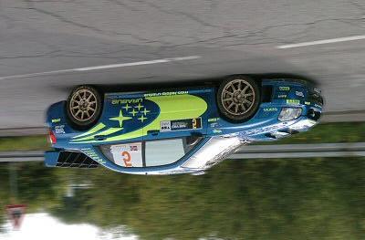


30 EGNOS Demonstration

 internet Compactness of")
31 Satellite Technology for Localisation Points to consider: Outdoor Large error block size Urban canyons Indoor? Signals through (wireless) internet Compactness of current devices Low cost mature technology
32 Contents ASK-IT Outline Technology in context Satellite technologies RFID Smartdust Mobile phone based technologies Wireless network based technologies Summary Conclusion

33 RFID System Radio Frequency IDentification A complete RFID system has three key components and maybe extended Image: GAO
 Inventory systems Freight handling Image: GAO The back (underside) of a typical simple RFID")
34 RFID System - Tags Quite mature technology Friend of Foe Comprises of antenna (wire coil), microchip and is most often stuck to the underside of a label Uses: Security (stock) Inventory systems Freight handling Image: GAO The back (underside) of a typical simple RFID tag

35 RFID
36 RFID Tag Classification By power: Passive Not powered Active Has internal battery or connected to an external power source Hence greater cost By radio frequency transmission ability: Passive RF Can only transmit data by reflecting incoming electromagnetic waves Active RF Can transmit data by using internal power source to power aerial and microchip
37 RFID Tag Classification By tag type: Type I Read-only Type II Read/write Type II+ As type II but with enhanced external features Type II++ As type II but with serial connection Type III Read/write plus LCD display Type IV Read/write as smartcard

38 Proximity smartcard and reader RFID Sytem - Reader RF passive, non-powered tags: Reader initiates conversation Reader emits RF energy that cause a current flow in the antenna and powers the chip Reader extracts data from the chip via the antenna and powers off RFID reader in stock room (

39 RFID System - Reader Powered, RF active tags: Reader or tag may initiate conversation Tag uses power source to power microchip and send data via antenna Range is larger than RF passive tags Read write tags may have new data written e.g. road user charging Image:


40 ate Road-91 Express Lanes (SR91) in Orange ounty, CA the first totally automated electronic toll llection system in the U.S Image:
41 RFID Performance Characteristics tags / s tags / s

42 RFID Tags Size and Costs Size: any size, from in car units smart cards stock labels millimetre dimensions A 0.25mm 2 RFID tag Image: smartcode Cost: average price for passive type I tags around 0,15-0,40 Ultra small in large quantities 0,05 More complex tags with long transmission range 17 ($20)
43 RFID Standards EPCglobal Class 1 Generation 2 RFID Specification Establishes a single UHF specification over several previous ones Sets minimum read and write speeds to 500 / 30 tags/sec

44 RFID for Localisation RFID tags in doorways, lifts, shop fronts, breadcrumb trail Map database integrated into reader Considerations: Power Range Low cost simple tags


45 Newcastle Smart Sign Project SmartSign NCLU/0008
46 Contents ASK-IT Outline Technology in context Satellite technologies RFID Smartdust Cellular phone based technologies Wireless network technologies Summary Conclusion


47 Images: intel, xbow Motes > smartdust Similar to Class IV RFID tags RF active Powered Tiny OS Sensor stack Smartdust (motes)

48 Ad Hoc Networks

49 Newcastle ASTRA project Smartdust corridor Network reporting of bus position Demonstration of use for localisation Various MSc projects


50 Newcastle Smartdust Corridor

51 Smartdust for Localisation Similar characteristics to RFID IEEE x standards widely used Hence better compatibility with existing equipment Costs: Current devices are not cheap 140 for MICA2 mote Smartdust costs will be signifcantly lower
52 Contents ASK-IT Outline Technology in context Satellite technologies RFID Smartdust Mobile phone based technologies Wireless network based technologies Summary Conclusion
53 Mobile phone based technologies Cellular mobile phone based GSM (TDMA) Triangulation method gives horizontal accuracy of meters 3G (CDMA) Smaller sized cells with greater overlapping accuracy more than that of TDMA networks 4G phones will have GPS chips inside to allow the phone to calculate it s position

54 Mobile phone based technologies Mobile Phone Features Good in urban areas where cells overlap Can be used indoors with additional network access points e.g. Metrocentre though leaky coaxial not suitable Tend to have good network strength around major road networks Limited signal in remote areas


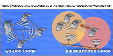
55 Wireless Networks Wireless networks Infrastructure based e.g. university network, device can detect range to nearest access points and calculate position Mobile ad-hoc Allows information from devices with knowledge to pass to other devices and so on e.g. traffic jams Bluetooth Smartdust
56 Key Issues 1. Technology must be compatible with the users mode of travel and application area 2. Accuracy of localisation signal 3. Compatibility with existing equipment 4. Unit cost 5. Combination & redundancy of technologies
57 References and links Kennedy Group European Space Agency SmartCode Corp. United States Government Accountability Office EPCglobal Inc. Intel Xbow Evans, J. 2005, Central London Congestion Charging Scheme, presentation, October 7th
Agenda Motivation Systems and Sensors Algorithms Implementation Conclusion & Outlook
 Overview of Current Indoor Navigation Techniques and Implementation Studies FIG ww 2011 - Marrakech and Christian Lukianto HafenCity University Hamburg 21 May 2011 1 Agenda Motivation Systems and Sensors
GNSS Programme. Overview and Status in Europe
 GNSS Programme Overview and Status in Europe Inaugural Forum Satellite Positioning Research and Application Center 23 April 2007 Tokyo Presented by Thomas Naecke (European Commission) Prepared by Daniel
Galileo. 7th ITFS, Rome, Italy, 3-5 November Dr. Stefan Bedrich. Kayser-Threde GmbH Wolfratshauser Str Munich
 Kayser-Threde GmbH Wolfratshauser Str. 48 81379 Munich spacetech@kayser-threde.com Galileo 7th ITFS, Rome, Italy, 3-5 November 2009 Dr. Stefan Bedrich w w w. k a y s e r - t h r e d e. c o m Outline Motivation
Case sharing of the use of RF Localization Techniques. Dr. Frank Tong LSCM R&D Centre LSCM Summit 2015
 Case sharing of the use of RF Localization Techniques Dr. Frank Tong LSCM R&D Centre LSCM Summit 2015 Outline A. LBS tracking and monitoring 1) Case of anti-wandering-off tracking vest system in elderly
ORBITAL NAVIGATION SYSTEMS PRESENT AND FUTURE TENDS
 ORBITAL NAVIGATION SYSTEMS PRESENT AND FUTURE TENDS CONTENT WHAT IS COVERED A BRIEF HISTORY OF SYSTEMS PRESENT SYSTEMS IN USE PROBLEMS WITH SATELLITE SYSTEMS PLANNED IMPROVEMENTS CONCLUSION CONTENT WHAT
Mobile Positioning in Wireless Mobile Networks
 Mobile Positioning in Wireless Mobile Networks Peter Brída Department of Telecommunications and Multimedia Faculty of Electrical Engineering University of Žilina SLOVAKIA Outline Why Mobile Positioning?
Global Navigation Satellite System (GNSS) GPS Serves Over 400 Million Users Today. GPS is used throughout our society
 GPS Serves Over 400 Million Users Today. GPS is used throughout our society") Global avigation Satellite System (GSS) For freshmen at CKU AA December 10th, 2009 by Shau-Shiun Jan ICA & IAA, CKU Global avigation Satellite System (GSS) GSS (Global Positioning System, GPS) Basics Today
Global avigation Satellite System (GSS) For freshmen at CKU AA December 10th, 2009 by Shau-Shiun Jan ICA & IAA, CKU Global avigation Satellite System (GSS) GSS (Global Positioning System, GPS) Basics Today
Principal Investigator Co-Principal Investigator Co-Principal Investigator Prof. Talat Ahmad Vice-Chancellor Jamia Millia Islamia Delhi
 Subject Paper No and Title Module No and Title Module Tag Geology Remote Sensing and GIS Concepts of Global Navigation Satellite RS & GIS XXXIII Principal Investigator Co-Principal Investigator Co-Principal
Galileo Aktueller Stand der Entwicklung
 Galileo Aktueller Stand der Entwicklung Is there a positive perspective for Galileo? Dr. Philipp Berglez TeleConsult Austria GmbH GSV-Forum Galileo das europäische Satellitennavigationssystem eine neue
RESPONSE TO THE HOUSE OF COMMONS TRANSPORT SELECT COMMITTEE INQUIRY INTO GALILEO. Memorandum submitted by The Royal Academy of Engineering
 RESPONSE TO THE HOUSE OF COMMONS TRANSPORT SELECT COMMITTEE INQUIRY INTO GALILEO Memorandum submitted by The Royal Academy of Engineering September 2004 Executive Summary The Royal Academy of Engineering
Report of the Working Group B: Enhancement of Global Navigation Satellite Systems (GNSS) Services Performance
 Services Performance") Report of the Working Group B: Enhancement of Global Navigation Satellite Systems (GNSS) Services Performance 1. The Working Group on Enhancement of Global Navigation Satellite Systems (GNSS) Service Performance
Report of the Working Group B: Enhancement of Global Navigation Satellite Systems (GNSS) Services Performance 1. The Working Group on Enhancement of Global Navigation Satellite Systems (GNSS) Service Performance
Understanding GPS: Principles and Applications Second Edition
 Understanding GPS: Principles and Applications Second Edition Elliott Kaplan and Christopher Hegarty ISBN 1-58053-894-0 Approx. 680 pages Navtech Part #1024 This thoroughly updated second edition of an
IMO WORLD-WIDE RADIONAVIGATION SYSTEM (WWRNS) GALILEO receiver performance standards. Submitted by the European Commission
 GALILEO receiver performance standards. Submitted by the European Commission") INTERNATIONAL MARITIME ORGANIZATION E IMO SUB-COMMITTEE ON SAFETY OF NAVIGATION 50th session Agenda item 13 2 April 2004 Original: ENGLISH WORLD-WIDE RADIONAVIGATION SYSTEM (WWRNS) GALILEO receiver performance
INTERNATIONAL MARITIME ORGANIZATION E IMO SUB-COMMITTEE ON SAFETY OF NAVIGATION 50th session Agenda item 13 2 April 2004 Original: ENGLISH WORLD-WIDE RADIONAVIGATION SYSTEM (WWRNS) GALILEO receiver performance
GALILEO AND EGNOS VALUE PROPOSITION FOR E112
 Ref. Ares(2014)1665692-22/05/2014 GALILEO AND EGNOS VALUE PROPOSITION FOR E112 Fiammetta Diani, Justyna REDELKIEWICZ European GNSS Agency (GSA) Brussels, 07/05/2014 Agenda European GNSS Agency at a glance
The EU Satellite Navigation programmes status Applications for the CAP
 The EU Satellite Navigation programmes status Applications for the CAP Michaël MASTIER European Commission DG ENTR GP3 GNSS Applications, Security and International aspects GPS Workshop 2010 Montpellier
Challenges and Solutions for GPS Receiver Test
 Challenges and Solutions for GPS Receiver Test Presenter: Mirin Lew January 28, 2010 Agenda GPS technology concepts GPS and GNSS overview Assisted GPS (A-GPS) Basic tests required for GPS receiver verification
Introduction to Galileo PRS
 Introduction to Galileo PRS Fabio Covello 20/09/2017 ESA UNCLASSIFIED - For Official Use Galileo mission figures The Galileo Space Segment: 30 satellites (full constellation) Walker 24/3/1 constellation
Bloodhound RMS Product Overview
 Page 2 of 10 What is Guard Monitoring? The concept of personnel monitoring in the security industry is not new. Being able to accurately account for the movement and activity of personnel is not only important
 Wireless Technology Wireless devices transmit information via Electromagnetic waves Early wireless devices Radios often called wireless in old WWII movies Broadcast TV TV remote controls Garage door openers
Introduction to Total Station and GPS
 Introduction to Total Station and GPS Dr. P. NANJUNDASWAMY Professor of Civil Engineering J S S Science and Technology University S J College of Engineering Mysuru 570 006 Introduction History GPS Overview
What s new in satellite navigation for road. Fiammetta Diani, Deputy Head Market Development Department European GNSS Agency
 What s new in satellite navigation for road Fiammetta Diani, Deputy Head Market Development Department European GNSS Agency May 2017 Why location (and satellite navigation) matters? 2 Galileo is the Satellite
Experiences with Fugro's Real Time GPS/GLONASS Orbit/Clock Decimeter Level Precise Positioning System
 Return to Session Directory DYNAMIC POSITIONING CONFERENCE October 13-14, 2009 Sensors Experiences with Fugro's Real Time GPS/GLONASS Orbit/Clock Decimeter Level Precise Positioning System Ole Ørpen and
GNSS Modernisation and Its Effect on Surveying
 Lawrence LAU and Gethin ROBERTS, China/UK Key words: GNSS Modernisation, Multipath Effect SUMMARY GPS and GLONASS modernisation is being undertaken. The current GPS modernisation plan is expected to be
GALILEO Research and Development Activities. Second Call. Area 3. Statement of Work
 GALILEO Research and Development Activities Second Call Area 3 Innovation by Small and Medium Enterprises Statement of Work Rue du Luxembourg, 3 B 1000 Brussels Tel +32 2 507 80 00 Fax +32 2 507 80 01
One Source for Positioning Success
 novatel.com One Source for Positioning Success RTK, PPP, SBAS OR DGNSS. NOVATEL CORRECT OPTIMIZES ALL CORRECTION SOURCES, PUTTING MORE POWER, FLEXIBILITY AND CONTROL IN YOUR HANDS. NovAtel CORRECT is the
The Global Positioning System
 The Global Positioning System 5-1 US GPS Facts of Note DoD navigation system First launch on 22 Feb 1978, fully operational in 1994 ~$15 billion (?) invested to date 24 (+/-) Earth-orbiting satellites
FieldGenius Technical Notes GPS Terminology
 FieldGenius Technical Notes GPS Terminology Almanac A set of Keplerian orbital parameters which allow the satellite positions to be predicted into the future. Ambiguity An integer value of the number of
Global navigation satellite systems (GNSS) - European Galileo system
 - European Galileo system") L E C T U R E 5 Global navigation satellite systems (GNSS) - European Galileo system Lecture 5 Overview Galileo GNSS Development Architecture Principle EGNOS GNSS applications GALILEO system GALILEO system
L E C T U R E 5 Global navigation satellite systems (GNSS) - European Galileo system Lecture 5 Overview Galileo GNSS Development Architecture Principle EGNOS GNSS applications GALILEO system GALILEO system
GPS Milestones, cont. GPS Milestones. The Global Positioning Sytem, Part 1 10/10/2017. M. Helper, GEO 327G/386G, UT Austin 1. US GPS Facts of Note
 The Global Positioning System US GPS Facts of Note DoD navigation system First launch on 22 Feb 1978, fully operational in 1994 ~$15 billion (?) invested to date 24 (+/-) Earth-orbiting satellites (SVs)
Introduction to Geographic Information Science. Last Lecture. Today s Outline. Geography 4103 / GNSS/GPS Technology
 Geography 4103 / 5103 Introduction to Geographic Information Science GNSS/GPS Technology Last Lecture Geoids Ellipsoid Datum Projection Basics Today s Outline GNSS technology How satellite based navigation
European GNSS Applications in H2020
 European GNSS Applications in H2020 Countdown to H2020 12.12.2013, Brussels Carmen Aguilera European GNSS Agency Agenda European GNSS Agency EU-GNSS market potential FP7- experience and results H2020 opportunities
UNITED NATIONS UNIVERSITY Institute for Environment & Human Security (UNU-EHS) Bonn, Germany
 Bonn, Germany") UNITED NATIONS UNIVERSITY Institute for Environment & Human Security (UNU-EHS) Bonn, Germany Introduction to GPS technology Prof. Dr. Jörg Szarzynski Education Programme Director Head of Section EduSphere
UNITED NATIONS UNIVERSITY Institute for Environment & Human Security (UNU-EHS) Bonn, Germany Introduction to GPS technology Prof. Dr. Jörg Szarzynski Education Programme Director Head of Section EduSphere
Next Generation Positioning Infrastructure
 Next Generation Positioning Infrastructure The GNSS Network in the 21 st Century Joel VAN CRANENBROECK & Partners Beyond East & West GeoSensing Community 1 INFRASTRUCTURE "The installations that form the
Galileo Programme Update
 Galileo Programme Update Pieter De Smet, European Commission ICTP Conference, Prague, 10 November, 2014 1 December 2014 The European GNSS Programmes 2 Secure Foundations ü A stable 7 years perspective
Positioning, location data and GNSS as solution for Autonomous driving
 Positioning, location data and GNSS as solution for Autonomous driving Jarkko Koskinen, Heidi Kuusniemi, Juha Hyyppä, Sarang Thombre and Martti Kirkko-Jaakkola FGI, NLS Definition of the Arctic 66 34 N
Status of the European EGNOS and Galileo Programmes. Frank Udnaes Galileo policy and Infrastructure group EC DG-TREN. June 2008
 Status of the European EGNOS and Galileo Programmes Frank Udnaes Galileo policy and Infrastructure group EC DG-TREN EUROPEAN COMMISSION z June 2008 Galileo An infrastructure 30 satellite Constellation
Overview of the global GNSS market and status of Galileo
 2012 GNSS.asia workshop Overview of the global GNSS market and status of Galileo 6 November, 2012 Taipei Justyna Redelkiewicz, European GNSS Agency European GNNS Agency supports European Commission in
EGNOS/GALILEO Status. Rafael Lucas Navigation Applications and User Services Office European Space Agency
 EGNOS/GALILEO Status Rafael Lucas Navigation Applications and User Services Office European Space Agency Rafael.Lucas.Rodriguez@esa.int European Satellite Navigation Strategy GNSS1: EGNOS Civil complement
Introduction to the Global Positioning System
 GPS for Fire Management - 2004 Introduction to the Global Positioning System Pre-Work Pre-Work Objectives Describe at least three sources of GPS signal error, and identify ways to mitigate or reduce those
NR402 GIS Applications in Natural Resources
 NR402 GIS Applications in Natural Resources Lesson 5 GPS/GIS integration Global Positioning System (GPS)..a global navigation system that everyone can use What is GPS? How does it work? How accurate is
Global Navigation Satellite Systems (GNSS)
") Global Navigation Satellite Systems (GNSS) Pat Norris MRAeS, FRIN LogicaCMG Business Development Manager Chairman, RAeS Space Group LogicaCMG 2006. All rights reserved 2 Global Navigation Satellite Systems
Global Navigation Satellite Systems (GNSS) Pat Norris MRAeS, FRIN LogicaCMG Business Development Manager Chairman, RAeS Space Group LogicaCMG 2006. All rights reserved 2 Global Navigation Satellite Systems
FAST AND LIABLE CARTOGRAPHY UPDATE USING EGNOS AND GALILEO
 (1) (2) FAST AND LIABLE CARTOGRAPHY UPDATE USING EGNOS AND GALILEO Manuel Toledo (1), Angel Gavín (2) GMV S.A., Isaac Newton 11, P.T.M. Tres Cantos, 28760 Madrid, Spain, E-mail: mtoledo@gmv.es; agavin@gmv.es
al T TD ) ime D Faamily Products The RTD Family of products offers a full suite of highprecision GPS sensor positioning and navigation solutions for:
 ime D Faamily Products The RTD Family of products offers a full suite of highprecision GPS sensor positioning and navigation solutions for:") Reeal ynnamics al T amics (R TD ) ime D RTD) Time Dy Faamily mily ooff P roducts Products The RTD Family of products offers a full suite of highprecision GPS sensor positioning and navigation solutions
Reeal ynnamics al T amics (R TD ) ime D RTD) Time Dy Faamily mily ooff P roducts Products The RTD Family of products offers a full suite of highprecision GPS sensor positioning and navigation solutions
High Precision GNSS in Automotive
 High Precision GNSS in Automotive Jonathan Auld, VP Engineering and Safety 6, March, 2018 2 Global OEM Positioning Solutions and Services for Land, Sea, and Air. GNSS in Automotive Today Today the primary
GBAS FOR ATCO. June 2017
 GBAS FOR ATCO June 2017 Disclaimer This presentation is for information purposes only. It should not be relied on as the sole source of information, and should always be used in the context of other authoritative
GTBIT ECE Department Wireless Communication
 Q-1 What is Simulcast Paging system? Ans-1 A Simulcast Paging system refers to a system where coverage is continuous over a geographic area serviced by more than one paging transmitter. In this type of
SMART RFID FOR LOCATION TRACKING
 SMART RFID FOR LOCATION TRACKING By: Rashid Rashidzadeh Electrical and Computer Engineering University of Windsor 1 Radio Frequency Identification (RFID) RFID is evolving as a major technology enabler
Engr 1202 ECE. Clean Room Project
 Engr 1202 ECE Clean Room Project Dilbert the engineer gets special recognition September 2005 2014 Version does not even have my name! AC vs. DC Circuits DC and AC devices in everyday life DC Devices
GE 113 REMOTE SENSING
 GE 113 REMOTE SENSING Topic 9. Introduction to Global Positioning Systems (GPS) and Other GNSS Technologies Lecturer: Engr. Jojene R. Santillan jrsantillan@carsu.edu.ph Division of Geodetic Engineering
Robust Positioning for Urban Traffic
 Robust Positioning for Urban Traffic Motivations and Activity plan for the WG 4.1.4 Dr. Laura Ruotsalainen Research Manager, Department of Navigation and positioning Finnish Geospatial Research Institute
Demonstrating Performance Levels of Positioning Technologies
 Demonstrating Performance Levels of Positioning Technologies Version 2.1 June 2009 GMV Aerospace and Defence S.A. c/ Isaac Newton 11 P.T.M. - Tres Cantos E-28760 Madrid SPAIN Tel.: +34-918 072 100 Fax:
EGNOS status and performance in the context of marine navigation requirements
 EGNOS status and performance in the context of marine navigation requirements J. Cydejko Gdynia Maritime University, Gdynia, Poland ABSTRACT: The current status of EGNOS (December 2006) is described as
The Galileo and EGNOS Programmes
 The Galileo and EGNOS Programmes Dominic Hayes European Commission ignss, Gold Coast, 14 July 2015 The European GNSS Programmes 2 Organisation and Contractual Frameworks European Union Member States (28)
The topic we are going to see in this unit, the global positioning system, is not directly related with the computer networks we use everyday, but it
 The topic we are going to see in this unit, the global positioning system, is not directly related with the computer networks we use everyday, but it is indeed a kind of computer network, as the specialised
RAPID DEVELOPMENT OF NAVIGATION PAYLOADS FOR GALILEO FULL OPERATIONAL CAPABILITY
 Changing the economics of space RAPID DEVELOPMENT OF NAVIGATION PAYLOADS FOR GALILEO FULL OPERATIONAL CAPABILITY Alex da Silva Curiel Dubai, January 2011 SSTL - the company UK-based satellite manufacturing
European Geostationary Navigation Overlay Service (EGNOS) Capability on Sirius 5 Satellite for SES
 Capability on Sirius 5 Satellite for SES") 21 October 2009 SES SIRIUS European Geostationary Navigation Overlay Service (EGNOS) Capability on Sirius 5 Satellite for SES Mike Pavloff, Executive Director, Space Systems/Loral Information included
21 October 2009 SES SIRIUS European Geostationary Navigation Overlay Service (EGNOS) Capability on Sirius 5 Satellite for SES Mike Pavloff, Executive Director, Space Systems/Loral Information included
An Introduction to Airline Communication Types
 AN INTEL COMPANY An Introduction to Airline Communication Types By Chip Downing, Senior Director, Aerospace & Defense WHEN IT MATTERS, IT RUNS ON WIND RIVER EXECUTIVE SUMMARY Today s global airliners use
Digital Surveillance Devices?
 Technology Framework Tracking Technologies Don Mason Associate Director Digital Surveillance Devices? Digital Surveillance Devices? Secure Continuous Remote Alcohol Monitor SCRAM Page 1 Location Tracking
Galileo Performance Update Rafael Lucas European Space Agency
 Galileo Performance Update Rafael Lucas European Space Agency United Nations/Argentina Workshop on the Applications of GNSS 19-23 March 2018, Falda del Carmen, Argentina ESA UNCLASSIFIED - For Official
MOBILE COMPUTING 2/25/17. What is RFID? RFID. CSE 40814/60814 Spring Radio Frequency IDentification
 MOBILE COMPUTING CSE 40814/60814 Spring 2017 What is RFID? Radio Frequency IDentification Who Are You? I am Product X RFID ADC (automated data collection) technology that uses radio-frequency waves to
Digital surveillance devices?
 Technology Framework Tracking Technologies Don Mason Associate Director Copyright 2011 National Center for Justice and the Rule of Law All Rights Reserved Digital surveillance devices? Digital surveillance
EUROPEAN COMMISSION Mission High Level Definition
 Mission High Level Definition April 3, 2001 Issue 2.0, 3 rd April 2001 Table of Contents Abstract... 1 1. Introduction... 2 1.1 Scope and Objective of the Document... 2 1.2 Approval and Management of the
DEFINING THE FUTURE OF SATELLITE SURVEYING WITH TRIMBLE R-TRACK TECHNOLOGY
 DEFINING THE FUTURE OF SATELLITE SURVEYING WITH TRIMBLE R-TRACK TECHNOLOGY EDMOND NORSE, GNSS PORTFOLIO MANAGER, TRIMBLE SURVEY DIVISION WESTMINSTER, CO USA ABSTRACT In September 2003 Trimble introduced
Precise Positioning... what does it mean? Precise GNSS Positioning Not just a niche technology. Chris Rizos 15/12/15
 Precise GNSS Positioning Not just a niche technology Chris Rizos Precise Positioning... what does it mean? 1 Precise Positioning... a spectrum of users... Few mm 1cm 2cm < dm 1dm sub-m Precision agriculture
Lecture-1 CHAPTER 2 INTRODUCTION TO GPS
 Lecture-1 CHAPTER 2 INTRODUCTION TO GPS 2.1 History of GPS GPS is a global navigation satellite system (GNSS). It is the commonly used acronym of NAVSTAR (NAVigation System with Time And Ranging) GPS (Global
Evaluating EGNOS technology in an ITS driving assistance application
 Evaluating EGNOS technology in an ITS driving assistance application A. Gómez Skarmeta H. Martínez Barberá M. Zamora Izquierdo J. Cánovas Quiñonero L. Tomás Balibrea Dept. of Communications and Information
Applications, Products and Services of GPS Technology
 Applications, Products and Services of GPS Technology Enrico C. Paringit. Dr. Eng. University of the Philippines Training Center for Applied Geodesy and Photogrammetry 1 Outline of this Presentation GPS
Galileo & EGNOS Programmes Status
 Galileo & EGNOS Programmes Status Ugo Celestino, European Commission EURO-MEDITERRANEAN TRANSPORT FORUM GNSS WORKING GROUP 16 th October 2012 17 October, 2012 The European GNSS Programmes 2 Table of contents
Distributed integrity monitoring of differential GPS corrections
 Distributed integrity monitoring of differential GPS corrections by Martin Pettersson Supervised by Fredrik Gustafsson Niclas Bergman Department of Automatic Control University of Linköpings Made for Luftfartsverket
Resection. We can measure direction in the real world! Lecture 10: Position Determination. Resection Example: Isola, Slovenia. Professor Keith Clarke
 Geography 12: Maps and Spatial Reasoning Lecture 10: Position Determination We can measure direction in the real world! Professor Keith Clarke Resection Resection Example: Isola, Slovenia Back azimuth
Introduction to GNSS opportunities in different Market Segments. Fiammetta Diani Market Development
 Introduction to GNSS opportunities in different Market Segments Fiammetta Diani Market Development fiammetta.diani@gsa.europa.eu 3-Mar-14 European GNSS Agency 2 Congratulations! Agenda European GNSS market
MGA Webinar Series : 1 Very Cheap RTK Receivers: Changing the Landscape of Positioning Services
 MGA Webinar Series : 1 Very Cheap RTK Receivers: Changing the Landscape of Positioning Services Dinesh Manandhar Center for Spatial Information Science The University of Tokyo Contact Information: dinesh@iis.u-tokyo.ac.jp
Testing of GNSS Dual-Frequency with Smartphones
 Testing of GNSS Dual-Frequency with Smartphones Towards better location performance in mass market applications P. Crosta, G. Galluzzo, R. Orus, R. Lucas, ESA J. Redelkiewicz, GSA ESA UNCLASSIFIED - For
EUROPEAN GNSS ADOPTION OPPORTUNITIES IN TRANSPORT WITH FOCUS ON RAIL
 EUROPEAN GNSS ADOPTION OPPORTUNITIES IN TRANSPORT WITH FOCUS ON RAIL Gian Gherardo Calini European GNSS Agency III Workshop GNSS Technology Advances in a Multi-Constellation Framework 22 January 2016 This
Nigerian Communications Satellite Ltd. (NIGCOMSAT)
") OVERVIEW OF NIGERIAN SATELLITE AUGMENTATION SYSTEM COMMENCING WITH PILOT DEMONSTRATION TO VALIDATE NATIONAL WORK PLAN presented by Dr. Lawal Lasisi Salami, NIGERIAN COMMUNICATIONS SATELLITE LTD UNDER FEDERAL
OVERVIEW OF NIGERIAN SATELLITE AUGMENTATION SYSTEM COMMENCING WITH PILOT DEMONSTRATION TO VALIDATE NATIONAL WORK PLAN presented by Dr. Lawal Lasisi Salami, NIGERIAN COMMUNICATIONS SATELLITE LTD UNDER FEDERAL
Global Positioning Systems (GPS) Trails: the achilles heel of mapping from the air / satellites
 Trails: the achilles heel of mapping from the air / satellites") Global Positioning Systems (GPS) Trails: the achilles heel of mapping from the air / satellites Google maps updated regularly by local users using GPS Also: http://openstreetmaps.org GPS applications
Global Positioning Systems (GPS) Trails: the achilles heel of mapping from the air / satellites Google maps updated regularly by local users using GPS Also: http://openstreetmaps.org GPS applications
GALILEO& EGNOS THE EU SATELLITE NAVIGATION PROGRAMMES EXPLAINED. Satellite Navigation EU SATNAV
 GALILEO& EGNOS THE EU SATELLITE NAVIGATION PROGRAMMES EXPLAINED EU SATNAV Satellite Navigation TABLE OF CONTENTS 22 GALILEO EGNOS EU SATELLITE NAVIGATION EUROPE MEETS SPACE...3 GALILEO, A SATELLITE NAVIGATION
Research in Ultra Wide Band(UWB) Wireless Communications
 Wireless Communications") The IEEE Wireless Communications and Networking Conference (WCNC'2003) Panel session on Ultra-wideband (UWB) Technology Ernest N. Memorial Convention Center, New Orleans, LA USA 11:05 am - 12:30 pm, Wednesday,
The IEEE Wireless Communications and Networking Conference (WCNC'2003) Panel session on Ultra-wideband (UWB) Technology Ernest N. Memorial Convention Center, New Orleans, LA USA 11:05 am - 12:30 pm, Wednesday,
Localization. of mobile devices. Seminar: Mobile Computing. IFW C42 Tuesday, 29th May 2001 Roger Zimmermann
 Localization of mobile devices Seminar: Mobile Computing IFW C42 Tuesday, 29th May 2001 Roger Zimmermann Overview Introduction Why Technologies Absolute Positioning Relative Positioning Selected Systems
Technical Specifications Document. for. Satellite-Based Augmentation System (SBAS) Testbed
 Testbed") Technical Specifications Document for Satellite-Based Augmentation System (SBAS) Testbed Revision 3 13 June 2017 Table of Contents Acronym Definitions... 3 1. Introduction... 4 2. SBAS Testbed Realisation...
Technical Specifications Document for Satellite-Based Augmentation System (SBAS) Testbed Revision 3 13 June 2017 Table of Contents Acronym Definitions... 3 1. Introduction... 4 2. SBAS Testbed Realisation...
GSA GNSS Technology Report Main highlights IPIN 2018
 GSA GNSS Technology Report Main highlights IPIN 2018 Justyna Redelkiewicz, European GNSS Agency 25 September 2018, Nantes The European GNSS Agency (GSA) is responsible for market development and operations
What is a GPS How does GPS work? GPS Segments GPS P osition Position Position Accuracy Accuracy Accuracy GPS A pplications Applications Applications
 What is GPS? What is a GPS How does GPS work? GPS Segments GPS Position Accuracy GPS Applications What is GPS? The Global Positioning System (GPS) is a precise worldwide radio-navigation system, and consists
GNSS Training for ITS Developers. Characterisation of EGNSS performances in relationship with the application requirements
 GNSS Training for ITS Developers Characterisation of EGNSS performances in relationship with the application requirements Table of Content egnss for Application: Main Challenges EGNOS and GALILEO Performances
GPS: The Basics. Darrell R. Dean, Jr. Civil and Environmental Engineering West Virginia University. Expected Learning Outcomes for GPS
 GPS: The Basics Darrell R. Dean, Jr. Civil and Environmental Engineering West Virginia University Expected Learning Outcomes for GPS Explain the acronym GPS Name 3 important tdt dates in history of GPS
S-Band: a new space for mobile communication in Europe Orazio Pulvirenti MSS Project Manager Eutelsat Innovation Team
 S-Band: a new space for mobile communication in Europe Orazio Pulvirenti MSS Project Manager Eutelsat Innovation Team Evolutions in Satellite Telecommunication Ground Segments Noordwijk, June 5 th 2008
CLICK HERE TO KNOW MORE
 CLICK HERE TO KNOW MORE Should GNSS Become a National Critical Infrastructure? Ooi Wei Han, Noordin Ahmad, Shahrizal IM National Space Agency (ANGKASA) Ministry of Science, Technology and Innovation (MOSTI)
Monitoring Station for GNSS and SBAS
 Monitoring Station for GNSS and SBAS Pavel Kovář, Czech Technical University in Prague Josef Špaček, Czech Technical University in Prague Libor Seidl, Czech Technical University in Prague Pavel Puričer,
Primer on GPS Operations
 MP Rugged Wireless Modem Primer on GPS Operations 2130313 Rev 1.0 Cover illustration by Emma Jantz-Lee (age 11). An Introduction to GPS This primer is intended to provide the foundation for understanding
AIREON SPACE-BASED ADS-B
 AIREON SPACE-BASED ADS-B 2018 Transport Canada Delegates Conference Steve Bellingham Manager, Navigation Systems Engineering Steve.Bellingham@navcanada.ca CNS/ATM Systems Communication Navigation Surveillance
Precise Positioning with Smartphones running Android 7 or later
 Precise Positioning with Smartphones running Android 7 or later * René Warnant, * Cécile Deprez, + Quentin Warnant * University of Liege Geodesy and GNSS + Augmenteo, Plaine Image, Lille (France) Belgian
GPS (Introduction) References. Terms
 References. Terms") GPS (Introduction) MSE, Rumc, GPS, 1 Terms NAVSTAR GPS ( Navigational Satellite Timing and Ranging - Global Positioning System) is a GNSS (Global Navigation Satellite System), developed by the US-DoD in
GPS (Introduction) MSE, Rumc, GPS, 1 Terms NAVSTAR GPS ( Navigational Satellite Timing and Ranging - Global Positioning System) is a GNSS (Global Navigation Satellite System), developed by the US-DoD in
GALILEO Workshop, 26.Sep Marco FALCONE GALILEO System Engineering Manager GALILEO Project Office Tel
 GALILEO Workshop, 26.Sep.2005 European Space Agency A g ence spatiale européenne ESTEC Postbus 299 - NL2200 AG Noordwijk - Keplerlaan - NL 2201 AZ Noordwijk ZH - Tel. (31) 71 5656565 - Fax (31) 71 5656040
Public or Private (2)
") // Public or Private () CCST90 Mar, 0 Dr. Hayden Kwok-Hay So Department of Electrical and Electronic Engineering The Making of Google Street View Google Street View Systematically capture photos of the
// Public or Private () CCST90 Mar, 0 Dr. Hayden Kwok-Hay So Department of Electrical and Electronic Engineering The Making of Google Street View Google Street View Systematically capture photos of the
36. Global Positioning System
 36. Introduction to the Global Positioning System (GPS) Why do we need GPS? Position: a basic need safe sea travel, crowed skies, resource management, legal questions Positioning: a challenging job local
Global Navigation Satellite Systems II
 Global Navigation Satellite Systems II AERO4701 Space Engineering 3 Week 4 Last Week Examined the problem of satellite coverage and constellation design Looked at the GPS satellite constellation Overview
FieldGenius Technical Notes GPS Differential Corrections
 FieldGenius Technical tes GPS Differential Corrections Introduction The accuracy requirement of survey grade or mapping grade GPS applications for real time positioning requires the use of differential
Introduction to the Global Positioning System
 GPS for ICS - 2003 Introduction to the Global Positioning System Pre-Work Pre-Work Objectives Describe at least three sources of GPS signal error, and ways to mitigate or reduce those errors. Identify
RECOMMENDATION ITU-R BS
 Rec. ITU-R BS.1350-1 1 RECOMMENDATION ITU-R BS.1350-1 SYSTEMS REQUIREMENTS FOR MULTIPLEXING (FM) SOUND BROADCASTING WITH A SUB-CARRIER DATA CHANNEL HAVING A RELATIVELY LARGE TRANSMISSION CAPACITY FOR STATIONARY
GEO 428: DEMs from GPS, Imagery, & Lidar Tuesday, September 11
 GEO 428: DEMs from GPS, Imagery, & Lidar Tuesday, September 11 Global Positioning Systems GPS is a technology that provides Location coordinates Elevation For any location with a decent view of the sky
Active Road Management Assisted by Satellite. ARMAS Phase II
 Active Road Management Assisted by Satellite ARMAS Phase II European Roundtable on Intelligent Roads Brussels, 26 January 2006 1 2 Table of Contents Overview of ARMAS System Architecture Field Trials Conclusions