CJ Jagadeesha,NDRF-IEI, Bangalore RM Vasagam,Chairman Aerospace Division Board,IEI LVM Reddy,Vice-President,IEI
|
|
|
- Maude James
- 5 years ago
- Views:
Transcription


1 CJ Jagadeesha,NDRF-IEI, Bangalore RM Vasagam,Chairman Aerospace Division Board,IEI LVM Reddy,Vice-President,IEI
![D] Geo informatics for assessing EWS in watersheds E] DSS for EW communication and policy](/docs-images/95/126093552/images/2-2.jpg "analysis aiming at sustainable development of resources F] Environmental data relay via")
2 D] Geo informatics for assessing EWS in watersheds E] DSS for EW communication and policy analysis aiming at sustainable development of resources F] Environmental data relay via satellites
3 Identity all connections to SCADA Networks Remove unnecessary connections to the SCADA network Evaluate and strengthen the security of any remaining connections to the SCADA network Flatten SCADA Networks by removing or disabling unnecessary services
4 Establish strong controls over any medium that is used as a backdoor into the SCADA network Perform technical audits of SCADA devices and networks and any other connected networks to identity security concerns. Establish SCADA red teams to identity evaluate possible attack Establish policies and conduct training to minimize the likelihood that organizational personnel will inadvertently disclose sensitive information

5 1.ARGOS Systems, GOES Systems, Meteosat Systems 2. Land Mobile Mapping Systems 3.Space borne digital Imaging sensors and systems 4. Small Satellite missions

6 Arduino EQ vibration sensors in active fault zones / strain measured zones InSAR based strain measurements throughout the 100 km / 200km buffer on epi center Quake Sats using Cubesats Smallsats for ionospheric disturbances Nearspace remote sensing
7 Large satellites- MODIS Channels 3.7 µ m (high gain 21 and low gain 22) to cover the MIR, 11 µ m TIR channel (32) - 1 km native resolution 2.1 µ m (MODIS 7 ch) at 500 m native resolution
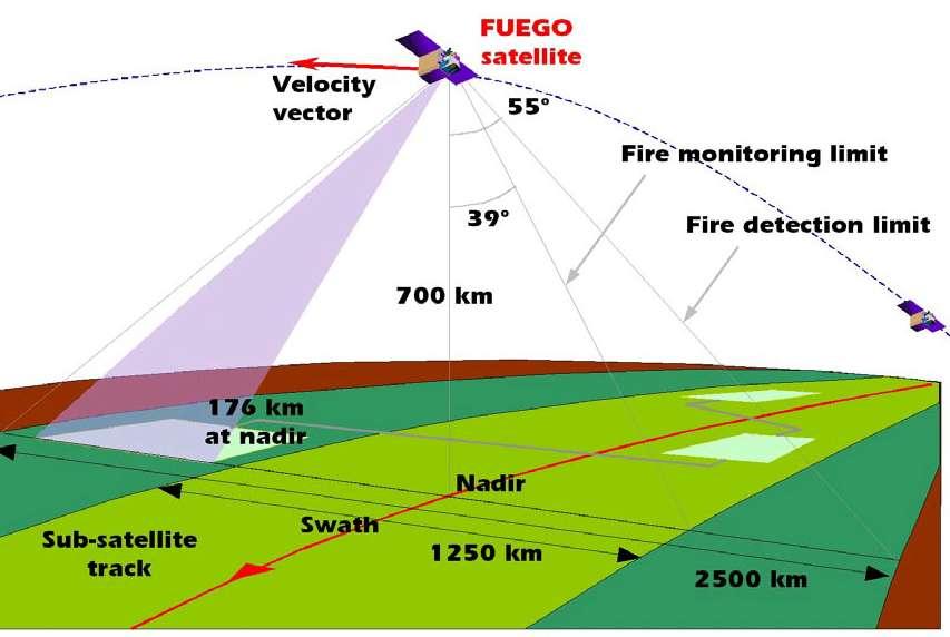
 + current and forecast weather conditions + GIS (PyroMap-fire mapping software) Distributed sensor networks FEUGO small")
8 NSW-Rural Fire Service in Australia: Airborne fire intelligence Dedaulus scanner ( multi spectral system with 12 bands) + NOAA AVHRR (thermally hot areas ) + current and forecast weather conditions + GIS (PyroMap-fire mapping software) Distributed sensor networks FEUGO small satellite

9
10 Baseline mission parameters Orbit Profile Altitude 700 Km Orbital inclination 47.5 deg Orbital period 98.8 min Orbital geometry Circular Satellite constellation design Number of satellites 12 Configuration Direct Walker (12/3/2) Symmetry Homogeneous Revisit time 23.8 min medium & 25.8 min maximum Service Continuous (24 h a day)

")
11 Marine Pollution Fisheries Control Illegal Immigration Drug Smuggling, cross border crime (edumping) Terrorism
12

![Six Satellites Plane E: [Equatorial] One](/docs-images/95/126093552/images/13-3.jpg "Satellite Plane P: [Polar] One to Two")
13 Satellite Planes ALL satellites to have AIS Planes A, B C and D: [45 Deg] Four to Six Satellites Plane E: [Equatorial] One Satellite Plane P: [Polar] One to Two Satellites
 imaging = Combining SAR sensors with timely AIS data provided ability to reliably detect vessels which")
14 ORBCOMM AIS AIS data (name, callsign, MMSI#, destination, etc) available in locations not supported by systems with which can provide specific vessel data sent ship and voyage information + Spaceborne SAR Sensors RADARSAT-1 and RADARSAT-2 offer all weather, low illumination (day/night) imaging = Combining SAR sensors with timely AIS data provided ability to reliably detect vessels which allowed for the rapid identification of the non-ais emitting ships
15 Sat AIS Inter-satellite comparison for detection rates Shared satellites for AIS Shared satellites- for Communication Critical maritime route program- Oil spill detection and finding the Offender
16 Conventional DART systems disadvantages : Cost /- dollars for one system. Maintenance per annum is /-dollars Life- two years only DSN of Sonabouys either on surface or bottom of oceans. They work on sonar signals. They can be designed to come to surface periodically, to reckon their positions by listening to GPS [ stealthy equivalents of UAVs] energy conserving, persistent and operational
17 It consists of : A. Mobile DAQ ( data acquisition unit) B. Fixed internet enabled pollution monitoring server (Pollution-Server) Unit A integrates a single chip microcontroller, air pollution sensors array, a General Packet Radio Service Modem ( GPRS Modem), and a Global Positioning System module (GPS-module)
18 Unit B is a high end personal computer application server with internet connectivity Unit A gathers air pollution levels (CO,NO2,and SO2), and packs them in a frame with the GPS physical location,time and date. The frame is subsequently uploaded to the GPRS-Modem and transmitted to the Pollution-server via the public mobile network.
19 A database server is attached to the Pollution- Server for storing the pollutants levels ( CO,NO2, and SO2), for further usage by various clients such as environment protection agencies, vehicles registration authorities, and tourist and insurance companies. [Ex: China, Iceland volcano and Europe ]
20
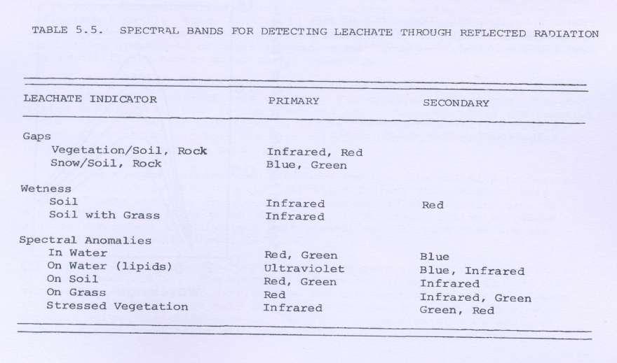
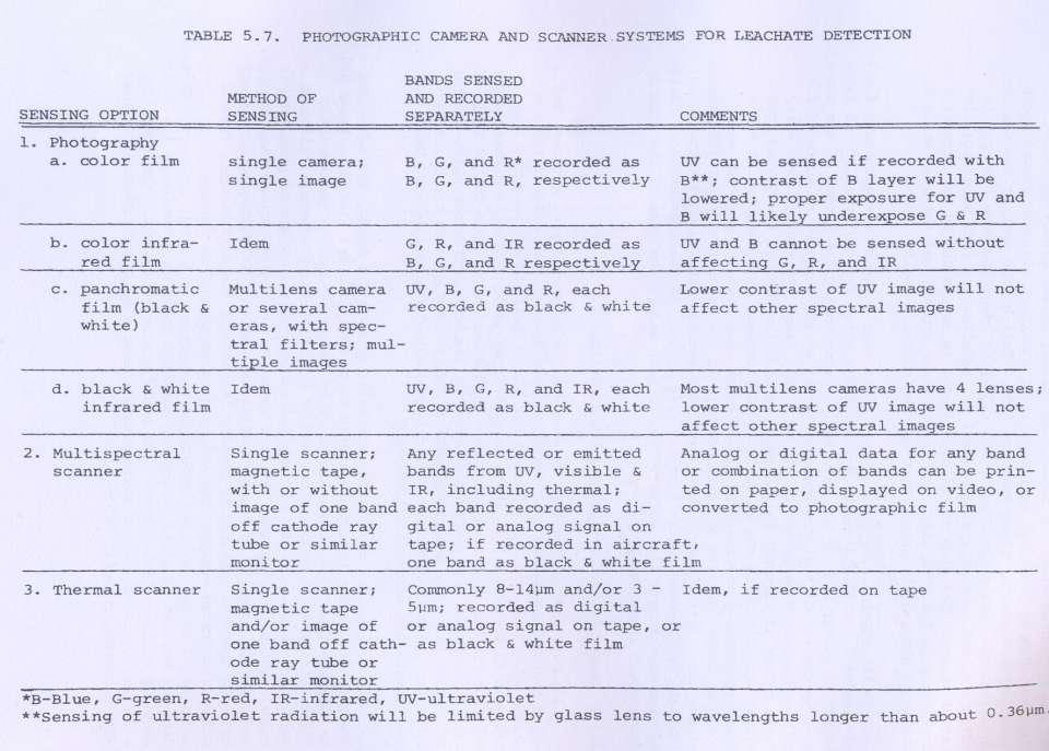
21 RS is for detecting environmental anomalies that may indicate contamination of ground and surface waters from landfill leachate RS techniques provide perspective and cost effectiveness not always available with other investigative techniques for monitoring landfills for environmental impact.

22
23
24
25 Technology readiness levels for monitoring the disaster in each country / for each technology it is different. How to match, economise and standardize?
26 Is it small satellites? Or Near space remote sensing? Or Large satellites? Or Distributed sensor networks,? Or UAVs? Or MICAVs? OR a combination of these
27 com [ Cell]
PEGASUS : a future tool for providing near real-time high resolution data for disaster management. Lewyckyj Nicolas
 PEGASUS : a future tool for providing near real-time high resolution data for disaster management Lewyckyj Nicolas nicolas.lewyckyj@vito.be http://www.pegasus4europe.com Overview Vito in a nutshell GI
Development of Microsatellite to Detect Illegal Fishing MS-SAT
 Development of Microsatellite to Detect Illegal Fishing MS-SAT Ernest S. C. P. Bintang A.S.W.A.M. Department of Aerospace Engineering Faculty of Mechanical and Aerospace Engineering Institut Teknologi
1. Detect and locate potentially illegal fishing ship using satellite image, AIS data, and external sources.
 Title: Development of Microsatellite to Detect Illegal Fishing MS-SAT Primary Point of Contact (POC) & email: Dr. Ridanto Eko Poetro; ridanto@ae.itb.ac.id Co-authors: Ernest Sebastian C., Bintang A.S.W.A.M.
SAR Interferometry Capabilities of Canada's planned SAR Satellite Constellation
 SAR Interferometry Capabilities of Canada's planned SAR Satellite Constellation Dirk Geudtner, Guy Séguin,, Ralph Girard Canadian Space Agency RADARSAT Follow-on Program CSA is in the middle of a Phase
NovaSAR-S - Bringing Radar Capability to the Disaster Monitoring Constellation
 Changing the economics of space NovaSAR-S - Bringing Radar Capability to the Disaster Monitoring Constellation SSTL: Philip Davies, Phil Whittaker, Rachel Bird, Luis Gomes, Ben Stern, Prof Sir Martin Sweeting
TerraSAR-X Applications Guide
 TerraSAR-X Applications Guide Extract: Maritime Monitoring: Ship Detection April 2015 Airbus Defence and Space Geo-Intelligence Programme Line Maritime Monitoring: Ship Detection Issue Maritime security
9/12/2011. Training Course Remote Sensing Basic Theory & Image Processing Methods September 2011
 Training Course Remote Sensing Basic Theory & Image Processing Methods 19 23 September 2011 Remote Sensing Platforms Michiel Damen (September 2011) damen@itc.nl 1 Overview Platforms & missions aerial surveys
Satellite services for maritime security
 Satellite services for ITS-T Sophia Antipolis 6 June 2007 Jean-Pierre Cauzac, CLS - Collecte Localisation Satellites 35 Are the seas becoming more dangerous? IMB report 2006 shows improvement: 239 piracy
Bloodhound RMS Product Overview
 Page 2 of 10 What is Guard Monitoring? The concept of personnel monitoring in the security industry is not new. Being able to accurately account for the movement and activity of personnel is not only important
Introduction to Remote Sensing Fundamentals of Satellite Remote Sensing. Mads Olander Rasmussen
 Introduction to Remote Sensing Fundamentals of Satellite Remote Sensing Mads Olander Rasmussen (mora@dhi-gras.com) 01. Introduction to Remote Sensing DHI What is remote sensing? the art, science, and technology
Space Based Vessel Detection - Combining Earth Observation and AIS for Maritime surveillance TEXAS V and C-Σ III
 Space Based Vessel Detection - Combining Earth Observation and AIS for Maritime surveillance TEXAS V and C-Σ III Tony Bauna Director, Product and Service Development, Kongsberg Satellite Services, Tromsø,
ERS/ENVISAT ASAR Data Products and Services
 ERS/ENVISAT ASAR Data Products and Services Andrea Celentano Business Manager celentan@eurimage.com What is Eurimage? Founded in 1989 Current shareholders: Since 1989 Commercial Partner of the European
The studies began when the Tiros satellites (1960) provided man s first synoptic view of the Earth s weather systems.
 provided man s first synoptic view of the Earth s weather systems.") Remote sensing of the Earth from orbital altitudes was recognized in the mid-1960 s as a potential technique for obtaining information important for the effective use and conservation of natural resources.
Remote sensing of the Earth from orbital altitudes was recognized in the mid-1960 s as a potential technique for obtaining information important for the effective use and conservation of natural resources.
KONGSBERG SATELLITE SERVICES Earth Observation for Maritime Operations Current Capabilities and Future Potential
 KONGSBERG SATELLITE SERVICES 2017 Earth Observation for Maritime Operations Current Capabilities and Future Potential Andreas Hay Kaljord Project Manager KSAT HQ IN TROMSØ - 69N WELCOME TO TROMSØ Established
Copernicus Introduction Lisbon, Portugal 13 th & 14 th February 2014
 Copernicus Introduction Lisbon, Portugal 13 th & 14 th February 2014 Contents Introduction GMES Copernicus Six thematic areas Infrastructure Space data An introduction to Remote Sensing In-situ data Applications
GLOBAL SATELLITE SYSTEM FOR MONITORING
 MEETING BETWEEN YUZHNOYE SDO AND HONEYWELL, International Astronautical Congress IAC-2012 DECEMBER 8, 2009 GLOBAL SATELLITE SYSTEM FOR MONITORING YUZHNOYE SDO PROPOSALS FOR COOPERATION WITH HONEYWELL EARTH
NON-PHOTOGRAPHIC SYSTEMS: Multispectral Scanners Medium and coarse resolution sensor comparisons: Landsat, SPOT, AVHRR and MODIS
 NON-PHOTOGRAPHIC SYSTEMS: Multispectral Scanners Medium and coarse resolution sensor comparisons: Landsat, SPOT, AVHRR and MODIS CLASSIFICATION OF NONPHOTOGRAPHIC REMOTE SENSORS PASSIVE ACTIVE DIGITAL
Demonstrator of a Data Processing Centre (DPC) for satellite-based AIS services
 for satellite-based AIS services") Page 1 Demonstrator of a Data Processing Centre (DPC) for satellite-based AIS services 19/20 April 2012 gfabritius@cls.fr Overview of the presentation Page 2 Introducing CLS Introducing AIS / SAT-AIS Scope
Page 1 Demonstrator of a Data Processing Centre (DPC) for satellite-based AIS services 19/20 April 2012 gfabritius@cls.fr Overview of the presentation Page 2 Introducing CLS Introducing AIS / SAT-AIS Scope
Cost Effective Control of your Coastal Waters
 Cost Effective Control of your Coastal Waters Olov Fäst SSC Airborne Systems 2013-07-03 SSC: A comprehensive space industry Founded in 1972 ~650 employees (2012) ~100 M turnover (2012) Since the start
Satellite data for Maritime Operations. Andreas Hay Kaljord Project Manager Energy, Environment & Security
 Satellite data for Maritime Operations Andreas Hay Kaljord Project Manager Energy, Environment & Security Kongsberg Satellite Services (KSAT) World leading provider within our business area Supports 85
Using satellite technology to monitor illegal, unreported, and unregulated (IUU) fishing
 fishing") Using satellite technology to monitor illegal, unreported, and unregulated (IUU) fishing Mark Richardson The Pew Charitable Trusts Blue Planet Symposium, June 2, 2017 The global threat of IUU fishing Illegal,
Using satellite technology to monitor illegal, unreported, and unregulated (IUU) fishing Mark Richardson The Pew Charitable Trusts Blue Planet Symposium, June 2, 2017 The global threat of IUU fishing Illegal,
9/12/2011. Training Course Remote Sensing Basic Theory & Image Processing Methods September 2011
 Training Course Remote Sensing Basic Theory & Image Processing Methods 19 23 September 2011 Popular Remote Sensing Sensors & their Selection Michiel Damen (September 2011) damen@itc.nl 1 Overview Low resolution
Copyright 2016 Raytheon Company. All rights reserved. Customer Success Is Our Mission is a registered trademark of Raytheon Company.
 Make in India Paradigm : Roadmap for a Future Ready Naval Force Session 9: Coastal Surveillance, Response Systems and Platforms Nik Khanna, President, India April 19, 2016 "RAYTHEON PROPRIETARY DATA THIS
Dimov Stojče Ilčev. CNS Systems
 Stratospheric Platform Systems (SPS) Presentation by: Dimov Stojče Ilčev Durban University of Technology (DUT) Space Science Centre (SSC) CNS Systems August 2011 SPS for Mobile CNS Applications Stratospheric
Utilization of Radar data for Maritime Surveillance
 INDESO Project Utilization of Radar data for Maritime Surveillance DENDY MAHABROR MARINE RESEARCH CENTER INDESO RADAR GROUND STATION RADARSAT-2 AND COSMO-SKYMED BALI INDESO satelit VMS satelite radar vessel
Principles of Remote Sensing. Shuttle Radar Topography Mission S R T M. Michiel Damen. Dept. Earth Systems Analysis
 Principles of Remote Sensing Shuttle Radar Topography Mission S R T M Michiel Damen Dept. Earth Systems Analysis Contents Present problems with DEMs Advantage of SRTM Cell size Mission and system Radar
Juan GAVIRIA, Sector Leader AFTTR
 Earth Observation in support of the Western Indian Ocean Marine Highway Development and Coastal and Marine Contamination Prevention Project - Oil spill detection & Coral reef monitoring Juan GAVIRIA, Sector
The Current Status and Brief Results of Engineering Model for PALSAR-2 onboard ALOS-2 and Science Project
 The Current Status and Brief Results of Engineering Model for PALSAR-2 onboard ALOS-2 and Science Project + The 16 th KC meeting Japan Aerospace Exploration Agency Masanobu Shimada, Yukihiro KANKAKU The
Western Indian Ocean Marine Highway Development and Coastal and Marine Contamination Prevention Project - Oil spill detection & Coral reef monitoring
 Earth Observation in support of the Western Indian Ocean Marine Highway Development and Coastal and Marine Contamination Prevention Project - Oil spill detection & Coral reef monitoring Juan GAVIRIA, Sector
Canadian Space Agency program update
 Canadian Space Agency program update Briefing to the meeting of the Expert Team on Satellite Systems (ET-SAT-11) Geneva, 4 April 2017 Guennadi Kroupnik Canadian Space Agency RADARSAT-2: CURRENT OPERATIONAL
RADAR SATELLITES AND MARITIME DOMAIN AWARENESS
 RADAR SATELLITES AND MARITIME DOMAIN AWARENESS J.K.E. Tunaley Corporation, 114 Margaret Anne Drive, Ottawa, Ontario K0A 1L0 (613) 839-7943 Report Documentation Page Form Approved OMB No. 0704-0188 Public
ISRO s EARTH OBSERVATION SYSTEM (updates from last Plenary) AS Kiran Kumar ISRO, INDIA
 AS Kiran Kumar ISRO, INDIA") ISRO s EARTH OBSERVATION SYSTEM (updates from last Plenary) AS Kiran Kumar ISRO, INDIA The 24 th CEOS Plenary Rio de Janeiro, Brazil 12-15 October, 2010 1 Four Decades of Indian Space Programme 30LV Missions
ISRO s EARTH OBSERVATION SYSTEM (updates from last Plenary) AS Kiran Kumar ISRO, INDIA The 24 th CEOS Plenary Rio de Janeiro, Brazil 12-15 October, 2010 1 Four Decades of Indian Space Programme 30LV Missions
Introduction Objective and Scope p. 1 Generic Requirements p. 2 Basic Requirements p. 3 Surveillance System p. 3 Content of the Book p.
 Preface p. xi Acknowledgments p. xvii Introduction Objective and Scope p. 1 Generic Requirements p. 2 Basic Requirements p. 3 Surveillance System p. 3 Content of the Book p. 4 References p. 6 Maritime
Sentinel-1 System Overview
 Sentinel-1 System Overview Dirk Geudtner, Rámon Torres, Paul Snoeij, Malcolm Davidson European Space Agency, ESTEC Global Monitoring for Environment and Security (GMES) EU-led program aiming at providing
Kongsberg Satellite Services, KSAT
 SvalSat, Earth Station at 78 North Kongsberg Satellite Services, KSAT Making Sense of Space Sigmund Dehli International Sales Manager WORLD CLASS through people, technology and dedication My plan KSAT
KONGSBERG SATELLITE SERVICES 2017 Line Steinbakk, Director Programs. Himmel og hav - Ålesund 3. Oktober 2017
 KONGSBERG SATELLITE SERVICES 2017 Line Steinbakk, Director Programs Himmel og hav - Ålesund 3. Oktober 2017 KSAT HQ IN TROMSØ 69N Established in 1967 Kongsberg Satellite Services since 2002 World leading
Introduction to KOMPSAT
 Introduction to KOMPSAT September, 2016 1 CONTENTS 01 Introduction of SIIS 02 KOMPSAT Constellation 03 New : KOMPSAT-3 50 cm 04 New : KOMPSAT-3A 2 KOMPSAT Constellation KOMPSAT series National space program
ORBCOMM Machine-To-Machine (M2M)
") ORBCOMM Machine-To-Machine (M2M) Texas V & C-Sigma November 2012 Global M2M Connecting the World s Assets Machine-To-Machine (M2M) Applications Global M2M Wireless Network for Narrowband Data Applications
ORBCOMM Machine-To-Machine (M2M) Texas V & C-Sigma November 2012 Global M2M Connecting the World s Assets Machine-To-Machine (M2M) Applications Global M2M Wireless Network for Narrowband Data Applications
Lecture 6: Multispectral Earth Resource Satellites. The University at Albany Fall 2018 Geography and Planning
 Lecture 6: Multispectral Earth Resource Satellites The University at Albany Fall 2018 Geography and Planning Outline SPOT program and other moderate resolution systems High resolution satellite systems
*For International Stewardship of the Maritime Environment and its Resources. Photo
 *For International Stewardship of the Maritime Environment and its Resources *For Maritime Safety *For Security Photo # Providing Environmental Monitoring* # Increasing Security* # Enabling Safety Efforts*
Satellite services and products for Automatic Weather Stations. Sophie Baudel
 Satellite services and products for Automatic Weather Stations Sophie Baudel sbaudel@cls.fr Share basic knowledge on telemetry services used by meteorologists and oceanographers for autonomous platforms
Rideshare-Initiated Constellations: Future CubeSat Architectures with the Current Launch Manifest
 Rideshare-Initiated Constellations: Future CubeSat Architectures with the Current Launch Manifest Joseph Gangestad, James Wilson, Kristin Gates, and John Langer The Aerospace Corporation National Space
Detection and Monitoring Through Remote Sensing....The Need For A New Remote Sensing Platform
 WILDFIRES Detection and Monitoring Through Remote Sensing...The Need For A New Remote Sensing Platform Peter Kimball ASEN 5235 Atmospheric Remote Sensing 5/1/03 1. Abstract This paper investigates the
REMOTE SENSING INTERPRETATION
 REMOTE SENSING INTERPRETATION Jan Clevers Centre for Geo-Information - WU Remote Sensing --> RS Sensor at a distance EARTH OBSERVATION EM energy Earth RS is a tool; one of the sources of information! 1
European Commission Workshop «SATELLITE IMAGERY AND ILLEGAL OIL SPILLS IN EUROPE AND IN THE MEDITERRANEAN» Round table 1 : «DETECTION TECHNIQUES»
 European Commission Workshop «SATELLITE IMAGERY AND ILLEGAL OIL SPILLS IN EUROPE AND IN THE MEDITERRANEAN» Round table 1 : «DETECTION TECHNIQUES» Round table 2 : «MUTUAL INFORMATION AND PROSECUTION PROCEDURES»
HEMERA Constellation of passive SAR-based micro-satellites for a Master/Slave configuration
 HEMERA Constellation of passive SAR-based micro-satellites for a Master/Slave HEMERA Team Members: Andrea Bellome, Giulia Broggi, Luca Collettini, Davide Di Ienno, Edoardo Fornari, Leandro Lucchese, Andrea
Multi Sensor Data Fusion
 Multi Sensor Data Fusion for improved maritime traffic monitoring in the Canadian Arctic Giulia Battistello*, Martin Ulmke*, Javier Gonzalez*, Camilla Mohrdieck** (*) Fraunhofer FKIE Sensor Data and Information
EELE 5451 Satellite Communications
 EELE 5451 Satellite Communications Introduction Applications include: Communications systems, Remote sensing (detection of water pollution, monitoring of weather conditions, search and rescue operations).
Abstract. 1. Introduction
 Title: Satellite surveillance for maritime border monitoring Author: H. Greidanus Number: File: GMOSSBordMon1-2.doc Version: 1-2 Project: GMOSS Date: 25 Aug 2004 Distribution: Abstract Present day remote
Important Missions. weather forecasting and monitoring communication navigation military earth resource observation LANDSAT SEASAT SPOT IRS
 Fundamentals of Remote Sensing Pranjit Kr. Sarma, Ph.D. Assistant Professor Department of Geography Mangaldai College Email: prangis@gmail.com Ph. No +91 94357 04398 Remote Sensing Remote sensing is defined
King AbdulAziz University. Faculty of Environmental Design. Geomatics Department. Mobile GIS GEOM 427. Lecture 3
 King AbdulAziz University Faculty of Environmental Design Geomatics Department Mobile GIS GEOM 427 Lecture 3 Ahmed Baik, Ph.D. Email: abaik@kau.edu.sa Eng. Fisal Basheeh Email: fbasaheeh@kau.edu.sa GNSS
Identification of Oil Spills from offshore installations.
 Identification of Oil Spills from offshore installations. Presentation of methods and preliminary results from the OSIS, Oil Spill Identification Sensor project. By: Jesper Holst OSIS International Tirsbaekvej
Co-ReSyF RA lecture: Vessel detection and oil spill detection
 This project has received funding from the European Union s Horizon 2020 Research and Innovation Programme under grant agreement no 687289 Co-ReSyF RA lecture: Vessel detection and oil spill detection
A CubeSat-Based Optical Communication Network for Low Earth Orbit
 A CubeSat-Based Optical Communication Network for Low Earth Orbit Richard Welle, Alexander Utter, Todd Rose, Jerry Fuller, Kristin Gates, Benjamin Oakes, and Siegfried Janson The Aerospace Corporation
CHC MINING DEFORMATION MONITORING SOLUTION
 CHC MINING DEFORMATION MONITORING SOLUTION Safety is first in mining. CHC offers solutions designed to improve safety for personnel on the ground and in the cab with 24/7 precision positioning for automatic
ENAiKOON inmarsat-600
 -600 Inmarsat modem for worldwide satellite communication -600 enables communication between trackables and the back-end system through satellite communication. -600 was designed specifically for fleet
Present and future IGS Ionospheric products
 Present and future IGS Ionospheric products Andrzej Krankowski, Manuel Hernández-Pajares, Joachim Feltens, Attila Komjathy, Stefan Schaer, Alberto García-Rigo, Pawel Wielgosz Outline Introduction IGS IONO
Sensor resolutions from space: the tension between temporal, spectral, spatial and swath. David Bruce UniSA and ISU
 Sensor resolutions from space: the tension between temporal, spectral, spatial and swath David Bruce UniSA and ISU 1 Presentation aims 1. Briefly summarize the different types of satellite image resolutions
An Introduction to Airline Communication Types
 AN INTEL COMPANY An Introduction to Airline Communication Types By Chip Downing, Senior Director, Aerospace & Defense WHEN IT MATTERS, IT RUNS ON WIND RIVER EXECUTIVE SUMMARY Today s global airliners use
Geospatial Vision and Policies Korean Industry View 26 November, 2014 SI Imaging Services
 Geospatial Vision and Policies Korean Industry View 26 November, 2014 SI Imaging Services Distribution Limitation, SI Imaging Services Proprietary Data : The data contained in this document, without the
Understanding AIS. The technology, the limitations and how to overcome them with Lloyd s List Intelligence
 Understanding AIS The technology, the limitations and how to overcome them with Lloyd s List Background to AIS The Automatic Identification System (AIS) was originally introduced in order to improve maritime
The Orbcomm Experience
 The Orbcomm Experience Jochen Harms OHB Technology Director of New Ventures Universitätsallee 27-29 28359 Bremen Germany Tel: +49 421 2020 9849 Fax: +49 421 2020 700 Email: harms@ohb-technology.de INTRODUCTION
SATELLITE MONITORING OF REMOTE PV-SYSTEMS
 SATELLITE MONITORING OF REMOTE PV-SYSTEMS Stefan Krauter, Thomas Depping UFRJ-COPPE-EE, PV-Labs, C. P. 68504, Rio de Janeiro 21945-970 RJ, BRAZIL Tel: +55-21-2562-8032, Fax: +55-21-22906626, E-mail: krauter@coe.ufrj.br
A Constellation of CubeSats for Amazon Rainforest Deforestation Monitoring
 4 th IAA Conference on University Satellites s & CubeSat Workshop - Rome, Italy - December 7, 2017 1 / 17 A Constellation of CubeSats for Monitoring Fernanda Cyrne Pedro Beghelli Iohana Siqueira Lucas
SAR missions for oceanography at the European Space Agency
 SAR missions for oceanography at the European Space Agency ERS-1, ERS-2, Envisat, Sentinel-1A, Sentinel-1B, ESA 3 rd Party Missions (ALOS) Prepared by ESA teams and ESA supporting companies ESA and SAR
remote sensing? What are the remote sensing principles behind these Definition
 Introduction to remote sensing: Content (1/2) Definition: photogrammetry and remote sensing (PRS) Radiation sources: solar radiation (passive optical RS) earth emission (passive microwave or thermal infrared
Govt. Engineering College Jhalawar Model Question Paper Subject- Remote Sensing & GIS
 Govt. Engineering College Jhalawar Model Question Paper Subject- Remote Sensing & GIS Time: Max. Marks: Q1. What is remote Sensing? Explain the basic components of a Remote Sensing system. Q2. What is
Integrating Spaceborne Sensing with Airborne Maritime Surveillance Patrols
 22nd International Congress on Modelling and Simulation, Hobart, Tasmania, Australia, 3 to 8 December 2017 mssanz.org.au/modsim2017 Integrating Spaceborne Sensing with Airborne Maritime Surveillance Patrols
Futrajaya, Malaysia JULY 12, Jeong Heon SONG. Korea Aerospace Research Institution
 J P T M 2 0 1 1 Futrajaya, Malaysia JULY 12, 2011 Jeong Heon SONG Korea Aerospace Research Institution Outline Contribution of KARI Sentinel Asia / Data Provider Node International Charter KARI Space Activities
DRONACHARYA GROUP OF INSTITUTIONS, GREATER NOIDA. SATELLITE COMMUNICATIONS (EEC 021) QUESTION BANK
 QUESTION BANK") DRONACHARYA GROUP OF INSTITUTIONS, GREATER NOIDA. SATELLITE COMMUNICATIONS (EEC 021) QUESTION BANK 1. Write the advantages and disadvantages of Satellite Communication. 2. Distinguish between active and
DRONACHARYA GROUP OF INSTITUTIONS, GREATER NOIDA. SATELLITE COMMUNICATIONS (EEC 021) QUESTION BANK 1. Write the advantages and disadvantages of Satellite Communication. 2. Distinguish between active and
(Refer Slide Time: 1:20)
") Introduction to Remote Sensing Dr. Arun K Saraf Department of Earth Sciences Indian Institute of Technology Roorkee Lecture 02 Development of Remote Sensing Technology & Advantages Hello! This is second
Introduction to Remote Sensing Dr. Arun K Saraf Department of Earth Sciences Indian Institute of Technology Roorkee Lecture 02 Development of Remote Sensing Technology & Advantages Hello! This is second
Project BONUS ESABALT
 Project BONUS ESABALT Economic and Non-Economic Feasibility Analysis dr Paweł Banaś Maritime University of Szczecin Content Assumptions 1. Analysis of navigational systems and devices 2. Expected ESABALT
The Ability of a Small Satellite Constellation to Tip and Cue Other Commercial Assets
 Changing the economics of space The Ability of a Small Satellite Constellation to Tip and Cue Other Commercial Assets Becky Cudzilo - Surrey Satellite US, LLC K.C. Foley - GeoEye, Inc. Chandler Smith -
Multispectral Scanners for Wildland Fire Assessment NASA Ames Research Center Earth Science Division. Bruce Coffland U.C.
 Multispectral Scanners for Wildland Fire Assessment NASA Earth Science Division Bruce Coffland U.C. Santa Cruz Slide Fire Burn Area (MASTER/B200) R 2.2um G 0.87um B 0.65um Airborne Science & Technology
Module 3 Introduction to GIS. Lecture 8 GIS data acquisition
 Module 3 Introduction to GIS Lecture 8 GIS data acquisition GIS workflow Data acquisition (geospatial data input) GPS Remote sensing (satellites, UAV s) LiDAR Digitized maps Attribute Data Management Data
REMOTE SENSING FOR FLOOD HAZARD STUDIES.
 REMOTE SENSING FOR FLOOD HAZARD STUDIES. OPTICAL SENSORS. 1 DRS. NANETTE C. KINGMA 1 Optical Remote Sensing for flood hazard studies. 2 2 Floods & use of remote sensing. Floods often leaves its imprint
Author s Name Name of the Paper Session. DYNAMIC POSITIONING CONFERENCE October 10-11, 2017 SENSORS SESSION. Sensing Autonomy.
 Author s Name Name of the Paper Session DYNAMIC POSITIONING CONFERENCE October 10-11, 2017 SENSORS SESSION Sensing Autonomy By Arne Rinnan Kongsberg Seatex AS Abstract A certain level of autonomy is already
Remote Sensing Exam 2 Study Guide
 Remote Sensing Exam 2 Study Guide Resolution Analog to digital Instantaneous field of view (IFOV) f ( cone angle of optical system ) Everything in that area contributes to spectral response mixels Sampling
Remote Sensing Platforms
 Types of Platforms Lighter-than-air Remote Sensing Platforms Free floating balloons Restricted by atmospheric conditions Used to acquire meteorological/atmospheric data Blimps/dirigibles Major role - news
INF-GEO Introduction to remote sensing
 INF-GEO 4310 Introduction to remote sensing Anne Solberg (anne@ifi.uio.no) Satellites, orbits and repeat cycles Optical remote sensings Based on a tutorial adapted from Canadian Center for Remote Sensing,
Enhanced Maritime Traffic Picture for the Canadian Arctic
 Enhanced Maritime Traffic Picture for the Canadian Arctic Giulia Battistello*, Martin Ulmke*, Camilla Mohrdieck** (*) Fraunhofer FKIE - Sensor Data and Information Fusion Department - Wachtberg, Germany
Satellite Technologies for Fisheries Monitoring, Control and Surveillance (MCS)
") JRC IPSC Maritime Affairs 1 Satellite Technologies for Fisheries Monitoring, Control and Surveillance (MCS) Juan Cicuendez, Marlene Alvarez JRC Info Day Madrid, 2 June 2010 IPSC - Institute for the Protection
JRC IPSC Maritime Affairs 1 Satellite Technologies for Fisheries Monitoring, Control and Surveillance (MCS) Juan Cicuendez, Marlene Alvarez JRC Info Day Madrid, 2 June 2010 IPSC - Institute for the Protection
Sensors, Tools and the Common Operating Picture. Sensors, Tools and the Common Operating Picture 14 th April Middleburg
 Sensors, Tools and the Common Operating Picture 14 th April 2015 - Middleburg Aptomar Established in 2005 Owned by Statoil, Investinor, Proventure Seed, Verdane Capitol Have developed and control all IPR
Satellite Imagery and Remote Sensing. DeeDee Whitaker SW Guilford High EES & Chemistry
 Satellite Imagery and Remote Sensing DeeDee Whitaker SW Guilford High EES & Chemistry whitakd@gcsnc.com Outline What is remote sensing? How does remote sensing work? What role does the electromagnetic
9/12/2011. Training Course Remote Sensing Basic Theory & Image Processing Methods September 2011
 Training Course Remote Sensing Basic Theory & Image Processing Methods 19 23 September 2011 Introduction to Remote Sensing Michiel Damen (September 2011) damen@itc.nl 1 Overview Some definitions Remote
Above All. The most sophisticated unit for tracking containers in real time for security and management.
 * The most sophisticated unit for tracking containers in real time for security and management. The French comedian Pierre Dac once said, To see into the distance, you simply need to get closer. That applies
What is a GPS How does GPS work? GPS Segments GPS P osition Position Position Accuracy Accuracy Accuracy GPS A pplications Applications Applications
 What is GPS? What is a GPS How does GPS work? GPS Segments GPS Position Accuracy GPS Applications What is GPS? The Global Positioning System (GPS) is a precise worldwide radio-navigation system, and consists
INTERNATIONAL JOURNAL OF PURE AND APPLIED RESEARCH IN ENGINEERING AND TECHNOLOGY
 INTERNATIONAL JOURNAL OF PURE AND APPLIED RESEARCH IN ENGINEERING AND TECHNOLOGY A PATH FOR HORIZING YOUR INNOVATIVE WORK SATELLITE COMMUNICATION AND ITS APPLICATIONS SHEETAL RAJPUT Dept. of Computer Science
Sustained Ocean Color Research and Operations
 Sustained Ocean Color Research and Operations What are the minimum requirements to continue the SeaWiFS/MODIS time-series? Based on a National Research Council report by the Ocean Studies Board May 2011
Indian Remote Sensing Satellites
 Resourcesat-1 Indian Remote Sensing Satellites -Current & Future Resourcesat Missions - Presented by: Timothy J. Puckorius Chairman & CEO EOTec 1 Presentation Topics India s Earth Observation Heritage
EverBlu. Wireless fixed data collection system
 Solution EverBlu Wireless fixed data collection system > Automatic daily meter reads > Graphical data analysis > Reliable self-healing wireless mesh network > Suitable for urban, suburban and rural environments
UAV applications for oil spill detection, suspended matter distribution and ice monitoring first tests and trials in Estonia 2015/2016
 UAV applications for oil spill detection, suspended matter distribution and ice monitoring first tests and trials in Estonia 2015/2016 Sander Rikka Marine Systems Institute at TUT 1.11.2016 1 Outlook Introduction
Technical Note TN5: Performance test procedures, methodology, data sources, quality of acquired AIS spaceborne data
 in cooperation with Institute of Space Systems Flight Operations Technical Note TN5: data sources, quality of acquired AIS spaceborne data Issue 2 August 2010 Preparatory Action for Assessment of the Capacity
Sentinel-1 Overview. Dr. Andrea Minchella
 Dr. Andrea Minchella 21-22/01/2016 ESA SNAP-Sentinel-1 Training Course Satellite Applications Catapult - Electron Building, Harwell, Oxfordshire Contents Sentinel-1 Mission Sentinel-1 SAR Modes Sentinel-1
Introduction Active microwave Radar
 RADAR Imaging Introduction 2 Introduction Active microwave Radar Passive remote sensing systems record electromagnetic energy that was reflected or emitted from the surface of the Earth. There are also
GNSS (GPS) buoy array in the Pacific for natural disaster mitigation. Teruyuki KATO Earthquake Research Institute the University of Tokyo, Japan
 buoy array in the Pacific for natural disaster mitigation. Teruyuki KATO Earthquake Research Institute the University of Tokyo, Japan") GNSS (GPS) buoy array in the Pacific for natural disaster mitigation Teruyuki KATO Earthquake Research Institute the University of Tokyo, Japan 1 (Modified from Oki & Koketsu, 2011) Historical megaquakes
GNSS (GPS) buoy array in the Pacific for natural disaster mitigation Teruyuki KATO Earthquake Research Institute the University of Tokyo, Japan 1 (Modified from Oki & Koketsu, 2011) Historical megaquakes
Drafting Committee for the Asia Pacific Plan of Action for Space Applications for Sustainable Development ( ) Republic of Korea
 Republic of Korea") Drafting Committee for the Asia Pacific Plan of Action for Space Applications for Sustainable Development (2018 2030) Republic of Korea Bangkok, Thailand 31 May 1 June 2018 김 1 KARI Introduction Government
Drafting Committee for the Asia Pacific Plan of Action for Space Applications for Sustainable Development (2018 2030) Republic of Korea Bangkok, Thailand 31 May 1 June 2018 김 1 KARI Introduction Government
Performance Assessment of Single and Dual-Frequency, Commercial-based GPS Receiver for LEO orbit
 1 Performance Assessment of Single and Dual-Frequency, Commercial-based GPS Receiver for LEO orbit Keisuke Yoshihara, Shinichiro Takayama, Toru yamamoto, Yoshinori Kondoh, Hidekazu Hashimoto Japan Aerospace
SAR Symposium Keynote Address *
 SAR SYMPOSIUM KEYNOTE ADDRESS SAR Symposium Keynote Address * Robert S. Winokur Spaceborne synthetic aperture radar (SAR) can provide a perspective of the Earth s surface that is nearly unique in scientific
Satellite Fleet Operations Using a Global Ground Station Network. Naomi Kurahara Infostellar
 Satellite Fleet Operations Using a Global Ground Station Network Naomi Kurahara Infostellar 1 Japanese university satellites Image via University Space Engineering Consortium, http://unisec.jp/wp/wp-content/uploads/2016/06/unisec_satellites_160120_jp_s.jpg