CROPOS positioning easier than ever
|
|
|
- Gwendolyn Madeleine Nelson
- 5 years ago
- Views:
Transcription


1 CROPOS positioning easier than ever M. Marjanovic, T. Basic State Geodetic Administration INF-0002 University of Zagreb - Faculty of Geodesy Republic of Croatia
2 Agenda Intro Croatia, State Geodetic Administration, Faculty of Geodesy CROPOS System National Geodetic GNSS Network New Geodetic Datum T7D New Transformation Model HRG2009 New Geoid Solution Implementation of Models in CROPOS Future Activities Conclusion

")


3 Croatia sq. kilometers ( sq. miles) Population 4,5 million Declaration of independance in 1991 Brac Plitvice Lakes Zadar Dubrovnik Pula
4 State Geodetic Administration National mapping and cadastral agency Legal, financial and inspection tasks Cadastre State survey > 1150 employees Central office in Zagreb, 20 cadstral offices and 92 branch offices State Geodetic Administration Republic of Croatia Gruska Zagreb Tel Fax
5 Faculty of Geodesy University of Zagreb Institutes for Geomatics, Applied geodesy, Cartography and photogrammetry > 100 employees Since 2005 new curriculum in accordance with the Bologna Declaration process Graduate, postgraduate specialist and PhD studies Faculty of Geodesy-University of Zagreb Republic of Croatia Kaciceva Zagreb Tel Fax
6 CROPOS Project The goal of the project was to establish a national system of reference GNSS stations of the Republic of Croatia Project started in 2004
7 Importance of CROPOS Project Introduction and application of a new geodetic datum of the Republic of Croatia Homogenization of coordinate system Same accuracy of coordinate determination at the entire territory of the Republic of Croatia Implementation of the unique measurement methods - standardization in performing of geodetic works Faster and more efficient performing of geodetic works
8 CROPOS Project Activities (1) Feasibility study - GTZ support (2004) PHARE Project Fiche Modernization and Capacity Building of Integrated Land Administration System in Croatia and Harmonization in the Pilot Area Component R3: CROPOS System Project approvement (September 2005) Financial agreement (December 2005)
9 CROPOS Project Activities (2) Network design reference station locations Installation of antenna carriers IT/ITC infrastructure project Tender documenation and technical specifications Tender launch (May 2007) Tender open (July 2007) Contract sign with Trimble Europe BV (November 2007)
10 CROPOS Project Activities (3) Equipment delivery (July 2008) Installation and configuration of system (August & September 2008) CROPOS in full functionality (October 2008) Field measurements system testing > 400 points (November 2008) CROPOS system launched on 9th of December 2008
11 CROPOS Project Budget PHARE-2005 Programme R3 CROPOS System: Contract value ,00 75% EU pre-accession funds 25% Croatian State Budget funds Croatian State Budget funds Contracts value ,00 Manufacturing and installation of antenna constructions Establishment of the required installations and telecommunications lines
12 CROPOS System - Definition CROPOS is a reference GNSS network of permanent stations of the Republic of Croatia enabling its users to determine a position with the GNSS technology in the real time with accuracy of 2 cm (positional) and 4 cm (vertical) on the entire territory of the Republic of Croatia
13 CROPOS System - Basics Collecting the data from the reference stations which are placed at 30 locations at the territory of the Republic of Croatia Reference station real-time GNSS data exchange with the neighbouring countries Networking and computing the real-time correction parameters Distribution of measuring data and real-time correction parameters to the users Monitoring of the system operation and users support 24/7 service availability

14


15 CROPOS System Components (1)
16 CROPOS System Components (2) GNSS reference stations NetR5 GPS + GLONASS receiver, Zephyr 2 Geodetic GNSS antenna (Trimble) Control centre System administration, processing and adjustment of data (HP) GPSNet/RTKNet Software (Trimble) Communication equipment - connecting of individual system components (CISCO) Data distribution equipment - distribution of RTCM & VRS RTCM correction parameters, distrubution of RINEX & Virtual RINEX data (HP + CISCO)
17 CROPOS Reference Stations


18

19 CROPOS Control Centre


20
21 CROPOS System Functionality Very high system reliability due to high quality of all system components (GNSS, IT/ITC, software) ~16 hours unplanned system failure power supply & Internet in 21 months (system availability 99.9%) Today - field surveying without CROPOS mission impossible

22
23 CROPOS System Services CROPOS DSP Real-time network solution Code measurements m VPPS Real-time network solution Phase measurements m GPPS Post-processing RINEX, VRS RINEX 0.01 m
24 CROPOS Reference Frame (1) BERNESE GPS SOFTWARE Ver sessions (24 hours) ITRF2005, (GPS week 1503) 30 CROPOS GNSS stations 5 IGS sites reference (Graz, Matera, Wettzell, Zimmerwald, Penc) 7 IGS sites processing control σ = 1.5 mm σ φ = 1.1 mm, σ λ = 1.2 mm, σ h = 3.4 mm ETRF00 (R05) (~ETRF89)

25 CROPOS Reference Frame (2)
26 CROPOS Reference Frame (3) IGS Site Country DX DY DZ (m) (m) (m) MEDI Italy POTS Germany KOSG Nederland GOPE Czech Republic JOZE Poland BRUS Belgium OSJE Croatia
27 CROPOS System Price list CROPOS SERVICE DATA FORMAT UNIT PRICE DPS Differential positioning in real-time VPPS High-precision positioning in real-time RTCM year HRK 1.000,00 (~135 ) RTCM 2.3 RTCM minute 1 year HRK 0,35 (~0,05 ) HRK 5.000,00 (~675 ) GPPS Geodetic precise positioning Post-processing RINEX RINEX VRS 1 minute HRK 0,50 (~0,07 ) Registration fee - HRK 300,00 (~40 )
28 CROPOS - User Support CROPOS flier CROPOS workshops (Rijeka, Split, Zagreb, Vinkovci November, 2008) > 800 participants CROPOS brochure CROPOS web page CROPOS user manual CROPOS newsletter CROPOS video 1. CROPOS users conference (Zagreb, 2009) > 350 participants (2. conference planned for 2011)


29 CROPOS flier CROPOS user manual


30 1. CROPOS users conference
31 CROPOS Statistics Increasing number of registered companies and users Average use of VPPS service (RTK) > minutes/month Average of 40 users connected at the same time during working hours (max. 79)
32 Number of registered companies - in total 302 march '09 april '09 may '09 june '09 july '09 august '09 september '09 october '09 november '09 december '09 january '10 february '10 march '10 april '10 may '10 june '10 july '10 august '10 september '10 Month, year Companies december '08 january '09 february '09 Companies
33 Number of service users - in total Users Users DPS VPPS GPPS Service
34 Payment models - VPPS service Users Users Flat rate Model Minute
35 600, , , , , ,000 - System usage - VPPS service - in total min. february '09 march '09 april '09 may '09 june '09 july '09 august '09 september '09 october '09 november '09 december '09 january '10 february '10 march '10 april '10 may '10 june '10 july '10 august '10 september '10 december '08 january '09 Month, year Minutes Minutes
36 180, , , , ,000 80,000 60,000 40,000 20,000 - System usage - GPPS service - in total min. december '08 ja nuary '09 fe bruary '09 m arch '09 april '0 9 m ay '09 ju ne '0 9 july '09 august '09 september '09 october '09 novembe r '09 december '09 january '10 february '10 march '10 april '1 0 may '10 june '1 0 july '10 august '10 septembe r '10 Month, year Minutes Minuta
37 CROPOS Current Status (1) 43 GNSS stations included in CROPOS network solution SIGNAL 7 TREB ILIB KOPE CRNO PTUJ BREZ VEPO NIZS GNSSnet.hu 4 BARC SIKL BALE CROPOS 30 MontePOS 2 NIKS TIVA
38 CROPOS Current Status (2) Hardware upgrade: data storage (+ 2 TB), tape backup (1 GB) Software update: Trimble GPSNet Ver , GNSS receiver firmware Ver Implementation of system for remote administration and system control of servers New application for user administration and charging, additional system usage statistics Processing of RINEX data in order to monitor and analyse stability of CROPOS reference frame GPS week solutions
 0. & 1. Order GNSS network")
39 National Geodetic GNSS Network (1) 1994 >1998 In total 6 GPS campaigns 78 points 0. & 1. order GNSS network Realization of HTRS96 (ITRF1996, ) 0. & 1. Order GNSS network
 1997 2001:")

40 National Geodetic GNSS Network (2) : 1023 points 2. order GNSS network (10 x 10 km)
 Central")


41 National Geodetic GNSS Network (3) Central geodetic point database Renovation of fundamental geodetic network control points Revision of geodetic points Klostar Ivanic Veli Vrh Kapavac
42 New Geodetic Datum Decree on establishing new official geodetic datums and map projections of the Republic of Croatia (August 2004) Horizontal datum HTRS96 Vertical datum HVRS71 Gravimetric datum - HGRS03 Plane map projections
43 Horizontal Datum European Terrestrial Reference System (abbreviated as ETRS89), is defined to be the official inalterable and time independent positional reference coordinate system for the Republic of Croatia GRS80 ellipsoid with the size of large halfaxis a= m and the flattening μ=1/ is determined to be the official mathematical model for the Earth s body in the Republic of Croatia
44 Transformation Problem (1) ETRF00 (R05), (ETRS89) GRS80 φ, λ, h (X, Y, Z) Ellipsoidal height: h HTRS96/TM GRS80 N, E, H (Transverse-Mercator projection) Orthometric height: H = h N (HVRS71) HDKS Bessel y, x, H (Gauss-Krüger projection) Orthometric height : H = h N (Trieste)
45 Transformation Problem (2) Transformation between geodetic datums: HTRS96 (Ellipsoid GRS80) < > HDKS (Ellipsoid Bessel) Local transformation (smaller areas) Satisfying accuracy but coordinate differences in border areas (up to 20 cm) inhomogeneity of trignometric network Global transformation (state level) Transformation method Molodensky 3D 7 parameters GRID Accuracy 5 m 1 m m
46 T7D new transformation model Unique transformation model HTRS96 <> HKDS - uniform, reliable and simple transformation system, primarily available to all users GRID transformation for the whole Croatian territory, consisting of 7-parameter transformation and a proper raster predicted values of distortion, both in plane coordinates and height
47 Identical points (Datum transformation) CROPOS N=2000 N=5200

48 T7 N= 5200 Transformation parameters Accuray estimation (m 0 = m) Tx m ± m Ty m ± m Tz m ± m Rx '' ± '' Ry '' ± '' Rz '' ± '' μ ppm ± ppm σ ϕ σλ σ h σ 2D σ 3D ± m ± m ± m ± m ± m
49 T7D Transformation Program Consisting of 7-parameter transformation + proper raster predicted values of distortion (both in plane coordinates and height) Distortion prediction least square collocation method (5200 points) > Grid in the regular 30 x 45 raster

50 T7D 7P + δφ, δλ (bi-linear interpolation) GRID Korekcija za φ,λ Interpolirana vrijednost σ ϕ σλ σ h σ 2D σ 3D ± m ± m ±0. 001m ± m ± m
51 HRG2009 New Geoid Solution First geoid solution HRG2000 Data: Earth s gravity field - free air anomalies (over 30000) Satellite altimetry in the Adriatic Sea (400) Global geopotential model EGM2008 High frequencies field structures modeled with the help of 3 x 3" Shuttle Radar DEM's Discrete geoid undulations obtained by GNSS/leveling on the mainland (495) Least squares collocation calculation technique Geoid surface point raster 30 x 45 Internal accuray σ = ±0.03 m Absolute accuracy based of comparison of GNSS/Leveling results (59 points not included in model) σ = ±0.04 m
 h N =")
52 GNSS/Levelling points (495) h N = h H
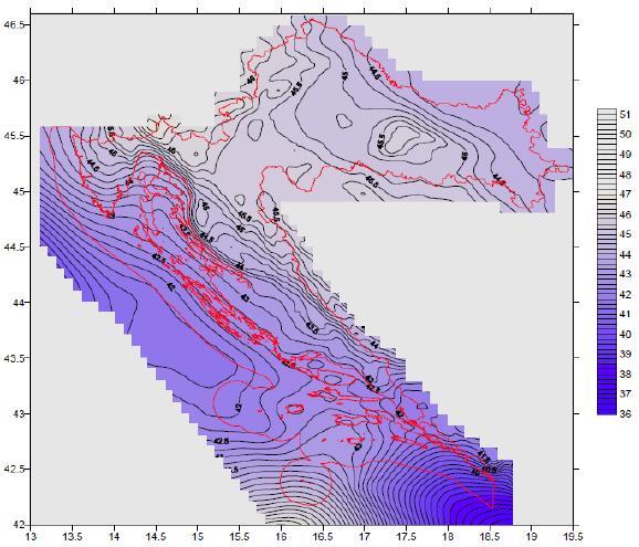
53 HRG2009
54 Implementation of Models in CROPOS Trimble Transformatin Generator New services > update CROPOS source table CROPOS_VRS_HTRS96 HTRS96/TM on-line geoid model CROPOS_VRS_HDKS HDKS datum transformation & on-line geoid model RTCM 3.1

55 RTCM 3.1 Messages Message parameter transformation (Tx, Ty, Tz, dm, Rx, Ry, Rz) Message 1023 Transformation corrections (δφ, δλ or N)
56 Transformation Data Flow NMEA NMEA RTCM 3.1 RTCM Generator Transformation parameters TTG Generator CROPOS NTRIP client 1 NTRIP client 2... NTRIP client n NTRIP Caster NTRIP Server NTRIP Server NTRIP Source NTRIP Source
57 Transformation Process Global Geodetic Datum Step 1: Message 1021 (Transformation parameters) Local Geodetic Datum Step 2: Message 1023 (Corrections - Grid) Local Geodetic Datum (Final coordinates)
58 Testing of on-line geoid model 1000 points (September/November 2010) Comparison of orthometric heights: on-line geoid model vs post-processing geoid model values

59 Testing on-line geoid model first results (1)
60 Testing on-line geoid model first results (2) ID H (m) HTRS96 H (m) T7D ΔH (mm) ID H (m) HTRS96 H (m) T7D ΔH (mm)
61 Future Activities Official use of on-line geoid model January 1st, 2011 Preparing of grid files for datum transformation and testing of on-line datum transformation (Spring 2011) Use of CROPOS data and procesing results in geodynamic research Organization of 2. CROPOS users conference (2011)
62 Conclusion CROPOS project Success story system design, planning installation cooperation with suppliers Trimble support Implementation of high quality hardware and software products User trust reliable and accepted system
63 Thank you!
CROPOS as Support of Geodetic Infrastructure in Croatia
 CROPOS as Support of Geodetic Infrastructure in Croatia Dr. Sc. Danko Markovinović - Croatia CLGE VicePresident The Geodetic Infrastructure in Europe - today and tomorrow Sweden...Umeå...22-23 June 2011
CROPOS CROatian POsitioning System
 Željko BAČIĆ, Marijan MARJANOVIĆ and Marinko BOSILJEVAC, Croatia Key words: network of referential GNNS station, positioning service SUMMARY During 2008, the State Geodetic Administration was building
National Report of Greece to EUREF 2009
 National Report of Greece to EUREF 2009 M. Gianniou KTIMATOLOGIO S.A. (Hellenic Cadastre) 1 Introduction In 2007, KTIMATOLOGIO S.A (Hellenic Cadastre) established HEPOS, the HEllenic POsitioning System,
DATUM TRANSFORMATION BETWEEN NATIONAL GEODETIC DATUM AND ITRF
 DATUM TRANSFORMATION BETWEEN NATIONAL GEODETIC DATUM AND ITRF M.Sc. Zlatko Bogdanovsk i FCE Skopje Chair for High Geodesy INTRODUCTION COORDINATE TRANSFORMATION Need of establishing dependence between
National Report of Greece to EUREF 2010
 National Report of Greece to EUREF 2010 M. Gianniou KTIMATOLOGIO S.A. (Hellenic Cadastre) 1 Introduction The HEllenic POsitioning System (HEPOS) is an RTK network consisting of 98 reference stations that
HEAD OFFICE OF GEODESY AND CARTOGRAPHY. Wspolna 2 Str., Warsaw, Poland ASG-EUPOS THE POLISH CONTRIBUTION TO THE EUPOS PROJECT
 HEAD OFFICE OF GEODESY AND CARTOGRAPHY Wspolna 2 Str., 00-926 Warsaw, Poland ASG-EUPOS THE POLISH CONTRIBUTION TO THE EUPOS PROJECT Project Part-Financed by European Union European Regional Development
NATIONAL REPORT OF SLOVENIA
 27th EUREF Symposium NATIONAL REPORT OF SLOVENIA Klemen Medved, Sandi Berk, Žarko Komadina, Jurij Režek (Surveying and Mapping Authority of the Republic of Slovenia, Ljubljana) Niko Fabiani, Katja Oven
Geodetic policy for Ireland and Northern Ireland
 Geodetic policy for Ireland and Northern Ireland Background Ordnance Survey Ireland (OSi) is the National Mapping Agency (NMA) of the Republic of Ireland. The Ordnance Survey of Northern Ireland (OSNI)
Cross-Border EUPOS Data Exchange First Experience
 Cross-Border EUPOS Data Exchange First Experience Eimuntas Paršeliūnas, Marius Petniūnas, Domantas Bručas (Institute of Geodesy of Vilnius Gediminas Technical University, Lithuania) Wieslaw Graszka (Head
KOPOS (KOsovo POsitioning System) ANALYSIS IN THE TESTING PHASE
 ANALYSIS IN THE TESTING PHASE") KOPOS (KOsovo POsitioning System) ANALYSIS IN THE TESTING PHASE Murat Meha Muzafer Çaka Reshat Murati 3 CROPOS Conference, Opatija, 24-25 October 2013 1 Chronology of system development Owner of the system:
KOPOS (KOsovo POsitioning System) ANALYSIS IN THE TESTING PHASE Murat Meha Muzafer Çaka Reshat Murati 3 CROPOS Conference, Opatija, 24-25 October 2013 1 Chronology of system development Owner of the system:
Philippine Geodetic Infrastructure Status, Challenges and Future Direction
 Philippine Geodetic Infrastructure Status, Challenges and Future Direction Engr. Charisma Victoria D. Cayapan National Mapping and Resource Information Authority PHILIPPINES Outline Evolution of Geodetic
LitPOS a part of EUPOS
 Project part-financed by the European Union LitPOS a part of EUPOS Eimuntas Parseliunas 1, Arunas Buga 1, Leonardas Marozas 1, Marius Petniunas 1, Saulius Urbanas 2 Abstract 1 Institute of Geodesy, Vilnius
ASG-EUPOS reference system
 Head Office of Geodesy and Cartography Department of Geodesy, Cartography and GIS ASG-EUPOS reference system Last year activities and future plans Szymon Wajda Prime specialist Bratislava, 21-22.11.2017
What makes the positioning infrastructure work. Simon Kwok Chairman, Land Surveying Division Hong Kong Institute of Surveyors
 What makes the positioning infrastructure work The experience of the Hong Kong Satellite Positioning Reference Station Network Simon Kwok Chairman, Land Surveying Division Hong Kong Institute of Surveyors
Template for CORS Networks
 Template for CORS Networks This template gives an idea on what can be included in the document or poster to describe the national or regional CORs network that your organisation is responsible for. The
PosKEN Related Activities in the Czech Republic
 Research Institute of Geodesy, Topography, and Cartography Geodetic Observatory Pecny Land Survey Office, Prague PosKEN Related Activities in the Czech Republic 2014-2015 National Report J. Šimek 1 and
Utilizing A GNSS Network Solution for Utility Applications
 Utilizing A GNSS Network Solution for Utility Applications David Newcomer, PE, PLS GPServ, Inc. newcomer@ (407) 601-5816 AGENDA Types and accuracies of data collection o Autonomous o Meter + o Sub-meter
Vertical Component Quality Comparison of GPS RTK Method in Combination with Laser System vs. Conventional Methods for Height Determination
 59 Vertical Component Quality Comparison of GPS RTK Method in Combination with Laser System vs. Conventional Methods for Height Determination Paar, R., Novakovi, G. and Kolovrat, D. University of Zagreb,
SKPOS. Slovak real-time positioning service - a multifunctional tool for precise object and phenomena positioning
 SKPOS Slovak real-time positioning service - a multifunctional tool for precise object and phenomena positioning WHAT IS SKPOS AND HOW DOES IT WORK? Slovak real-time positioning service is a multifunctional
National report of Ukraine
 National report of Ukraine O. Kucher (1), A. Marchenko (3), O. Renkevich (1), S. Savchuk (3), I. Zaiats (2) 1) Research Institute of Geodesy and Cartography, Kyiv, Ukraine 2) State Service of Geodesy,
Trimble GPSNet 2.5 Software for GNSS Infrastructure: New Features. Martin Janousek - Trimble Technical Support - Infrastructure
 Trimble GPSNet 2.5 Software for GNSS Infrastructure: New Features Martin Janousek - Trimble Technical Support - Infrastructure GPSNet Users Seminar Munich, March 30 th /31 th 2006 Overview Support for
NATIONAL REPORT OF SLOVENIA
 Paper presented at the 18th EUREF Symposium held in Brussels, Belgium, 18 21 June 2008 NATIONAL REPORT OF SLOVENIA B. STOPAR1, B. KOLER1, M. KUHAR1, S. BERK2, D. RADOVAN2 1 Introduction This paper is the
Trimble GNSS Infrastructure
 Trimble GNSS Infrastructure A History of Innovation Trimble, the first company to offer commercial GPS products company to integrate GPS with communications technology RTK system in the market in 1994
EUPOS: Unified GNSS Augmentation Infrastructure and International Cooperation in Central and Eastern Europe
 EUPOS: Unified GNSS Augmentation Infrastructure and International Cooperation in Central and Eastern Europe Senate Department for Urban Development Geodetic Reference Systems Fehrbelliner Platz 1, 10707
Monitoring tool for EUPOS countries network RTK quality
 Monitoring tool for EUPOS countries network RTK quality Dr. Branislav Droščák & Karol Smolík Geodetic and Cartographic Institute BRATISLAVA EUPOS WG on Service Quality Monitoring branislav.droscak@skgeodesy.sk,
Connecting a Cadastral Survey to PNG94 using GNSS
 43rd Association of Surveyors PNG Congress, Lae, 12th-15th August 2009 Connecting a Cadastral Survey to PNG94 using GNSS Richard Stanaway QUICKCLOSE Workshop overview Legal requirements to connect surveys
European Position Determination System. Technical Standards
 European Position Determination System Technical Standards Revised 2 nd Edition 24 April 2008 Resolution of the International EUPOS Steering Committee 13 th Conference, Bucharest, Romania, 23 24 April
SERVIR: The Portuguese Army CORS Network for RTK
 SERVIR: The Portuguese Army CORS Network for RTK António Jaime Gago AFONSO, Rui Francisco da Silva TEODORO and Virgílio Brito MENDES, Portugal Key words: GNSS, RTK, VRS, Network ABSTRACT Traditionally
OPTIMUM GEODETIC DATUM TRANSFORMATION TECHNIQUES FOR GPS SURVEYS IN EGYPT
 Proceedings of Al-Azhar Engineering Sixth International Conference, Sept. 1-, 2000, Cairo, Egypt, Volume, pp. 09-1. OPTIMUM GEODETIC DATUM TRANSFORMATION TECHNIQUES FOR GPS SURVEYS IN EGYPT By Dr. Gomaa
ASG-EUPOS DENSIFICATION OF EUREF PERMANENT NETWORK ON THE TERRITORY OF POLAND
 ASG-EUPOS DENSIFICATION OF EUREF PERMANENT NETWORK ON THE TERRITORY OF POLAND 1. INTRODUCTION Jarosław Bosy 1,2) Artur Oruba 1) Wieslaw Graszka 1) Marcin Leonczyk 1) Marcin Ryczywolski 1) 1) Head Office
ELEMENTS OF THE NATIONAL SPATIAL REFERENCE SYSTEM
 Dave Doyle NGS Chief Geodetic Surveyor dave.doyle@noaa.gov 301-713-3178 ELEMENTS OF THE NATIONAL SPATIAL REFERENCE SYSTEM ESRI SURVEY SUMMIT San Diego, CA June 17, 2007 ftp://ftp.ngs.noaa.gov/dist/daved/esri
The Reasons to Succeed or to Fail a GNSS Network RTK Project
 The Reasons to Succeed or to Fail a GNSS Network RTK Project Joël van Cranenbroeck, Managing Director CGEOS Creative Geosensing sprl-s, Belgium Andy Yin, International Sales Director ComNav Technology
FieldGenius Technical Notes GPS Terminology
 FieldGenius Technical Notes GPS Terminology Almanac A set of Keplerian orbital parameters which allow the satellite positions to be predicted into the future. Ambiguity An integer value of the number of
Connecting a Survey to PNG94 and MSL using GNSS
 45th Association of Surveyors PNG Congress, Madang, 19-22 July 2011 Connecting a Survey to PNG94 and MSL using GNSS Richard Stanaway QUICKCLOSE Workshop overview Legal requirements to connect surveys to
Development of Geoid Based Vertical Datums, A New Zealand Perspective
 Technical Seminar Reference Frame in Practice, Development of Geoid Based Vertical Datums, A New Zealand Perspective Matt Amos Manager Positioning and Innovation Land Information New Zealand Sponsors:
Definition and use of the New Zealand Vertical Datum Matt Amos Senior Advisor Geodesy
 Definition and use of the New Zealand Vertical Datum 2009 Matt Amos Senior Advisor Geodesy NZIS Continuing Professional Development Programme, November 2009 Overview Height Theory Heights in New Zealand
THE NEW RTCM 3.1 TRANSFORMATION MESSAGES
 THE NEW RTCM 3.1 TRANSFORMATION MESSAGES Declaration, Generation from Reference Transformations and Implementation as a Server-Client-Concept for GNSS Services Prof. Dr. Reiner Jäger 1), 2) and Dipl.-Ing.
Accuracy Testing of RTK Service of the Permanent Station Network in the Republic of Serbia
 Accuracy Testing of RTK Service of the Permanent Station Network in the Republic of Serbia Siniša DELĈEV, Vukan OGRIZOVIĆ, Violeta VASILIĆ and Jelena GUĈEVIĆ, Serbia Key words: GPS, RTK, accuracy, permanent
GNSS 101 Bringing It Down To Earth
 GNSS 101 Bringing It Down To Earth Steve Richter Frontier Precision, Inc. UTM County Coordinates NGVD 29 State Plane Datums Scale Factors Projections Session Agenda GNSS History & Basic Theory Coordinate
Investigation of GNSS Receiver s Accuracy Integrated on UAVs
 Investigation of GNSS Receiver s Accuracy Integrated on UAVs Željko BAČIĆ, Danijel ŠUGAR, Roko GRZUNOV, Croatia Key words: GNSS, Unmanned Aerial Vehicle, PPK, Testing Platform SUMMARY UASs (Unmanned Aerial
GNSS & Coordinate Systems
 GNSS & Coordinate Systems Matthew McAdam, Marcelo Santos University of New Brunswick, Department of Geodesy and Geomatics Engineering, Fredericton, NB May 29, 2012 Santos, 2004 msantos@unb.ca 1 GNSS GNSS
Lecture # 7 Coordinate systems and georeferencing
 Lecture # 7 Coordinate systems and georeferencing Coordinate Systems Coordinate reference on a plane Coordinate reference on a sphere Coordinate reference on a plane Coordinates are a convenient way of
Overview of New Datums NOAA s National Geodetic Survey
 Overview of New Datums NOAA s National Geodetic Survey February 3, 2015 1 NGS s Mission and Role NGS Mission: To define, maintain, and provide access to the National Spatial Reference System to meet our
AUSPOS GPS Processing Report
 AUSPOS GPS Processing Report February 13, 2012 This document is a report of the GPS data processing undertaken by the AUSPOS Online GPS Processing Service (version: AUSPOS 2.02). The AUSPOS Online GPS
The Global Positioning System II Field Experiments
 The Global Positioning System II Field Experiments 5-1 Mexico DGPS Field Campaign Cenotes in Tamaulipas, MX, near Aldama 5-2 Are Cenote Water Levels Related? 5-3 DGPS Static Survey of Cenote Water Levels
European Position Determination System (EUPOS )
") European Position Determination System (EUPOS ) Georgi MILEV, Bulgaria, Gerd ROSENTHAL, Germany and Keranka VASSILEVA, Bulgaria Key words: ABSTRACT The project EUPOS is an initiative to establish a uniform
European Position Determination System (EUPOS ) Georgi MILEV, Bulgaria, Gerd ROSENTHAL, Germany and Keranka VASSILEVA, Bulgaria Key words: ABSTRACT The project EUPOS is an initiative to establish a uniform
Trimble NetR9 Reference Receiver Series: Frequently Asked Questions
 July 2010 Trimble NetR9 Reference Receiver Series: Frequently Asked Questions What is the Trimble NetR9 GNSS reference receiver? The Trimble NetR9 GNSS (Global Navigation Satellite System) reference receiver
IMO WORLDWIDE RADIONAVIGATION SYSTEM (WWRNS) Study on Communication Techniques for High Accuracy DGPS in the Republic of Korea
 Study on Communication Techniques for High Accuracy DGPS in the Republic of Korea") INTERNATIONAL MARITIME ORGANIZATION E IMO SUB-COMMITTEE ON SAFETY OF NAVIGATION 52nd session Agenda item 12 NAV 52/INF.8 12 May 2006 ENGLISH ONLY WORLDWIDE RADIONAVIGATION SYSTEM (WWRNS) Study on Communication
INTERNATIONAL MARITIME ORGANIZATION E IMO SUB-COMMITTEE ON SAFETY OF NAVIGATION 52nd session Agenda item 12 NAV 52/INF.8 12 May 2006 ENGLISH ONLY WORLDWIDE RADIONAVIGATION SYSTEM (WWRNS) Study on Communication
LONG-TERM POSITIONAL MONITORING OF STATION VYHL OF THE SNĚŽNÍK NETWORK
 Acta Geodyn. Geomater., Vol. 4, No. 4 (148), 201-206, 2007 LONG-TERM POSITIONAL MONITORING OF STATION VYHL OF THE SNĚŽNÍK NETWORK Otakar ŠVÁBENSKÝ * and Josef WEIGEL Brno University of Technology, Department
New Tools for Network RTK Integrity Monitoring
 New Tools for Network RTK Integrity Monitoring Xiaoming Chen, Herbert Landau, Ulrich Vollath Trimble Terrasat GmbH BIOGRAPHY Dr. Xiaoming Chen is a software engineer at Trimble Terrasat. He holds a PhD
Integrated geodetic infrastructure at the Geodetic Observatory Pecný, Czech Republic, in service of national and international GNSS projects
 Integrated geodetic infrastructure at the Geodetic Observatory Pecný, Czech Republic, in service of national and international GNSS projects Pavel NOVÁK, Czech Republic Key words: geodesy, reference systems,
OF POLAND TO EUREF 2009
 NATIONAL REPORT OF POLAND TO EUREF 2009 Jan Krynski Institute of Geodesy and Cartography, Warsaw Jerzy B. Rogowski Warsaw University of Technology, Warsaw Outline Main geodetic activities at the national
Accuracy assessment of free web-based online GPS Processing services and relative GPS solution software
 82 Accuracy assessment of free web-based online GPS Processing services and relative GPS solution software Khaled Mahmoud Abdel Aziz Department of Surveying Engineering, Shoubra Faculty of Engineering,
GNSS Application trends in Central Asia
 GNSS Application trends in Central Asia GIS Open 2014, April 15-17, 2014, Székesfehérvár, Hungary Akylbek Chymyrov PhD Candidate, Faculty of Geoinformatics University of West-Hungary Docent of the Geodesy
Precise Positioning GNSS Applications
 Precise Point Positioning: Is the Era of Differential GNSS Positioning Drawing to an End? School of Surveying & Spatial Information Systems, UNSW, Sydney, Australia Chris Rizos 1, Volker Janssen 2, Craig
The Global Positioning Sytem II 10/19/2017
 The Global Positioning System II Field Experiments 10/19/2017 5-1 Mexico DGPS Field Campaign Cenotes in Tamaulipas, MX, near Aldama 10/19/2017 5-2 Are Cenote Water Levels Related? 10/19/2017 5-3 M. Helper,
Progress Towards the Seamless Combination of Bathymetric and Topographic Data in New Zealand
 Progress Towards the Seamless Combination of Bathymetric and Topographic Data in New Zealand Matt Amos Senior Technical Advisor National Geodetic Office Introduction Datasets usually defined in terms of
NATIONAL REPORT OF POLAND TO EUREF 2012
 NATIONAL REPORT OF POLAND TO EUREF 2012 Jan Krynski Institute of Geodesy and Cartography, Warsaw Jerzy B. Rogowski Warsaw University of Technology, Warsaw Outline Main geodetic activities at the national
An NGS Illustrated Guide to Geodesy for GIS Professionals
 An NGS Illustrated Guide to Geodesy for GIS Professionals Michael Dennis, RLS, PE michael.dennis@noaa.gov Esri User Conference San Diego Convention Center July 14-18, 2014 San Diego, CA Why should we care
The Fehmarnbelt Positioning System for a Mega Construction Site
 The Fehmarnbelt Positioning System for a Mega Construction Site Bastian Huck 1, Anna Jensen 2, Anders Almholt 3, Jürgen Rüffer 4 1 AXIO-NET GmbH, Hannover, Germany mail: bastian.huck@axio-net.eu 2 AJ Geomatics,
Salient Feature of ITRF. Realization of Dubai Emirate Datum. Reference Frame 2000 (Ditr 2000)
") Salient Feature of ITRF on the Reference Frame 2000 (Ditr 2000) ITRF stands for International Terrestrial Reference Frame ITRF established by the International Earth Rotation Service (IERS), France. One
Salient Feature of ITRF on the Reference Frame 2000 (Ditr 2000) ITRF stands for International Terrestrial Reference Frame ITRF established by the International Earth Rotation Service (IERS), France. One
SOME ASPECT AND PERSPECTIVES OF IMPLEMENTATION OF THE NATIONAL POLICY IN THE FIELD OF EXPLORATION AND PEACEFUL USES OF OUTER SPACE
 SOME ASPECT AND PERSPECTIVES OF IMPLEMENTATION OF THE NATIONAL POLICY IN THE FIELD OF EXPLORATION AND PEACEFUL USES OF OUTER SPACE 1 Folie 1 NKS Raumfahrt, Dr. Adrian klein Background National Academy
Datums and Tools to Connect Geospatial Data Accurately
 Datums and Tools to Connect Geospatial Data Accurately Pamela Fromhertz Colorado State Geodetic Advisor National Geodetic Survey National Oceanic and Atmospheric Administration GIS-T April 18, 2012 Loveland,
Status and plans for reference networks and systems in Denmark The Geodetic Infrastructure in Europe Umeå - Sweden, June 22-23, 2011
 Status and plans for reference networks and systems in Denmark The Geodetic Infrastructure in Europe Umeå - Sweden, June 22-23, 2011 Mette Weber and Lola Bahl National Survey and Cadastre - Denmark Content
Real-Time GNSS EUREF-IP Pilot Project
 Real-Time GNSS EUREF-IP Pilot Project G. Weber, BKG, Frankfurt 1. Status: Network, coverage, contributors 2. White Paper: Real-time GNSS in Routine EPN Operations 3. Real-time GNSS tools: BNC, client for
Terrestrial Reference Frame of Serbia and its temporal rate
 Belgrade University Faculty of Civil Engineering Terrestrial Reference Frame of Serbia and its temporal rate Sofija Naod, Sanja Grekulović, Violeta Vasilić Oleg Odalović, Dragan Blagojević Department of
The Global Positioning System II Field Experiments. 10/10/2013 GEO327G/386G, UT Austin 5-1
 The Global Positioning System II Field Experiments 10/10/2013 GEO327G/386G, UT Austin 5-1 Mexico DGPS Field Campaign Cenotes in Tamaulipas, MX, near Aldama 10/10/2013 GEO327G/386G, UT Austin 5-2 Are Cenote
EUREF Related Activities in the Czech Republic
 Research Institute of Geodesy, Topography, and Cartography Geodetic Observatory Pecny Land Survey Office, Prague EUREF Related Activities in the Czech Republic 2014-2015 National Report J. Douša 1, V.
Introduction to Datums James R. Clynch February 2006
 Introduction to Datums James R. Clynch February 2006 I. What Are Datums in Geodesy and Mapping? A datum is the traditional answer to the practical problem of making an accurate map. If you do not have
NTRIP Background History, Development & BKG. Networked Transport of RTCM via Internet Protocol
 Networked Transport of RTCM via Internet Protocol Networked Transport of RTCM via Internet Protocol Bundesamt für Kartographie und Geodäsie Motivation: Use Internet to transport GNSS corrections Communication
EUREF Permanent GNSS Network Carine Royal Observatory of Belgium
 ENEON first workshop Observing Europe: Networking the Earth Observation Networks in Europe EUREF Permanent GNSS Network Carine Bruyninx/C.Bruyninx@oma.be Royal Observatory of Belgium 1. About your network
MGA Webinar Series : 1 Very Cheap RTK Receivers: Changing the Landscape of Positioning Services
 MGA Webinar Series : 1 Very Cheap RTK Receivers: Changing the Landscape of Positioning Services Dinesh Manandhar Center for Spatial Information Science The University of Tokyo Contact Information: dinesh@iis.u-tokyo.ac.jp
From Passive to Active Control Point Networks Evaluation of Accuracy in Static GPS Surveying
 From Passive to Active Control Point Networks Evaluation of Accuracy in Static GPS Surveying P. Häkli 1, U. Kallio 1 and J. Puupponen 2 1) Finnish Geodetic Institute 2) National Land Survey of Finland
RELEASE NOTES. Introduction. Trimble NetR9 Infrastructure GNSS Series Receivers
 RELEASE NOTES Trimble NetR9 Infrastructure GNSS Series Receivers These release notes describe the latest improvements made to the Trimble Infrastructure GNSS series receivers. Introduction New Features
SUPPORT OF NETWORK FORMATS BY TRIMBLE GPSNET NETWORK RTK SOLUTION
 SUPPORT OF NETWORK FORMATS BY TRIMBLE GPSNET NETWORK RTK SOLUTION TRIMBLE TERRASAT GMBH, HARINGSTRASSE 19, 85635 HOEHENKIRCHEN, GERMANY STATUS The Trimble GPSNet network RTK solution was first introduced
HEIGHTING WITH GPS: POSSIBILITIES AND LIMITATIONS
 HEIGHTING WITH GPS: POSSIBILITIES AND LIMITATIONS Matthew B. Higgins ABSTRACT Global Positioning System (GPS) surveying is now seen as a true three dimensional tool and GPS heighting can be a viable alternative
RELEASE NOTES. Introduction. Trimble Infrastructure GNSS Series Receivers
 RELEASE NOTES Trimble Infrastructure GNSS Series Receivers These release notes describe the latest improvements made to the Trimble NetR9 GNSS Infrastructure series receivers. Introduction New Features
A NEW GEOCENTRIC DATUM FOR NEW ZEALAND
 A NEW GEOCENTRIC DATUM FOR NEW ZEALAND Don Grant Graeme Blick Office of Surveyor-General Land Information New Zealand PO Box 5501 Wellington New Zealand Phone 04 4600100 Fax 04 4722244 dgrant@linz.govt.nz
Accuracy Evaluation Internet-Based GNSS for Kinematic Surveying the Case Study in Thailand
 Accuracy Evaluation Internet-Based GNSS for Kinematic Surveying the Case Study in Thailand Kritsada Anantakarn 1 1 Faculty of Engineering and Architectural : Uthenthawai campus. Rajamongala University
Towards a EUREF Service Providing Real-time GNSS Clock and Orbit Corrections
 Towards a EUREF Service Providing Real-time GNSS Clock and Orbit Corrections G. Weber 1), W. Söhne 1), A. Stürze 1), L. Mervart 2) 1) Federal Agency for Cartography and Geodesy, Frankfurt am Main, Germany
EUREF Related Activities
 Symposium of the IAG Subcommission for Europe (EUREF) Chisinau, Moldova, 25 28 May, 2011 National Report of the Czech Republic EUREF Related Activities in the Czech Republic 2010-2011 National Report presented
Standard for the Australian Survey Control Network
 Standard for the Australian Survey Control Network Special Publication 1 Intergovernmental Committee on Survey and Mapping (ICSM) Geodesy Technical Sub-Committee (GTSC) 30 March 2012 Table of contents
CGG. Office of the Surveyor General of the Federation Federal Capital Territory, Abuja, Nigeria 2
 Prof. P. C. Nwilo 1, * Dr. J. D. Dodo 2, U. R. Edozie 1, and A. Adebomehin 1. 1 Office of the Surveyor General of the Federation Federal Capital Territory, Abuja, Nigeria 2 Centre for Geodesy and Geodynamics,
Performance Evaluation Of Real Time Precise Point Positioning (RT-PPP) In Static & Kinematic Modes In Egypt
 In Static & Kinematic Modes In Egypt") Performance Evaluation Of Real Time Precise Point Positioning (RT-PPP) In Static & Kinematic Modes In Egypt Eng. Ahmed Mansour Abdallah Dr. Mahmoud Abd Rabbou Prof. Adel El.shazly Geomatic Branch, Civil
Performance Evaluation Of Real Time Precise Point Positioning (RT-PPP) In Static & Kinematic Modes In Egypt Eng. Ahmed Mansour Abdallah Dr. Mahmoud Abd Rabbou Prof. Adel El.shazly Geomatic Branch, Civil
Integrity Monitoring in a VRS Network
 Integrity Monitoring in a VRS Network Bundesamt für Landestopografie Office fédéral de topographie Ufficio federale di topografia Uffizi federal da topografia Simon Grünig, swisstopo GPSNet User Conference,
Leica GRX1200 Series High Performance GNSS Reference Receivers
 Leica GRX1200 Series High Performance GNSS Reference Receivers Leica GRX1200 Series For permanent reference stations The Leica GRX1200 Series, part of Leica s new System 1200, is designed specifically
Stations and Datum Transformation
 Continuously Operating Referene Stations and Datum Transformation (CORS-TR) Ali Kılıçoğlu Geodesy Department, GCM Turkey ali.kilicoglu@hgk.mil.tr EUREF 2009, 26-29 May 2009, Firenze, Italy 147 CORS 2 Control
Multi-constellation GNSS baseline solutions a perspective from the user's and developer's point of view
 Multi-constellation GNSS baseline solutions a perspective from the user's and developer's point of view Danijel ŠUGAR, Croatia, Boris SKOPLJAK, United States of America, Željko BAČIĆ, Croatia Key words:
Overview of New Datums
 Overview of New Datums Scott Lokken NC Advisor NOAA s National Geodetic Survey 9/4/2015 1 New Datums are Coming in 2022! Both a new geometric and a new geopotential (vertical) datum will be released in
Alberding solutions for GNSS infrastructure operators
 Tamás Horváth Alberding solutions for GNSS infrastructure operators 21.11.2017 1/35 Alberding solutions for GNSS infrastructure operators Tamás Horváth Alberding GmbH 4 th EUPOS Technical Meeting 21-22
LSD PQSL Series Geodetic Survey. Prepared by Mr KWOK King-hung 22 May 2015
 LSD PQSL Series 2015 Geodetic Survey Prepared by Mr KWOK King-hung 22 May 2015 1 Geodesy Source from Wiki May 2015 also known as geodetics or geodetics engineering a branch of applied mathematics and earth
Leica GRX1200+ Series High Performance GNSS Reference Receivers
 Leica GRX1200+ Series High Performance GNSS Reference Receivers Leica GRX1200+ Series For permanent reference stations The Leica GRX1200+ Series, part of Leica's future proof System 1200, is designed specifically
ROMPOS FOR CADASTRE APPLICATIONS
 International Symposium on Global Navigation Satellite Systems, Space-Based and Ground-Based Augmentation Systems and Applications 2009; Berlin, Germany, 30 November - 2 December 2009 ROMPOS FOR CADASTRE
Comparative analysis of GNSS Real Time Kinematic methods for navigation
 IAV Hassan II Comparative analysis of GNSS Real Time Kinematic methods for navigation Mourad BOUZIANI School of Geomatic Sciences, IAV Hassan II, Rabat, Morocco. Coordinator of the Master - GNSS, IAV&
Determining Accurate Elevations: Datums & Tools, Today & Tomorrow
 Determining Accurate Elevations: Datums & Tools, Today & Tomorrow Association of State Floodplain Managers Annual Meeting Grand Rapids, MI Christine Gallagher June 21, 2016 Overview NGS Mission Important
Next Generation Positioning Infrastructure
 Next Generation Positioning Infrastructure The GNSS Network in the 21 st Century Joel VAN CRANENBROECK & Partners Beyond East & West GeoSensing Community 1 INFRASTRUCTURE "The installations that form the
RELEASE NOTES. Trimble. SPS Series Receivers. Introduction. New features and changes
 RELEASE NOTES Trimble SPS Series Receivers Introduction New features and changes Version 4.42 Revision A June 2011 F Corporate office Trimble Navigation Limited Engineering and Construction group 5475
Standard for New Zealand Vertical Datum 2016 LINZS25009
 Standard for New Zealand Vertical Datum 2016 LINZS25009 Effective Date: 27 June 2016 Table of Contents TERMS ND DEFINITIONS... 3 FOREWORD... 5 INTRODUCTION... 5 PURPOSE OF STNDRD... 5 BRIEF HISTORY OF
Unification of height systems in the frame of GGOS
 Unification of height systems in the frame of GGOS Laura Sánchez Deutsches Geodätisches Forschungsinstitut der Technischen Universität München (DGFI-TUM) Centrum für Geodätische Erdsystemforschung (CGE)
Enhancing the Swiss Permanent GPS Network (AGNES) for GLONASS
 for GLONASS") Enhancing the Swiss Permanent GPS Network (AGNES) for GLONASS D. INEICHEN, E. BROCKMANN, S. SCHAER 1 1 Abstract Since 1998 swisstopo has been operating the Automated GPS Network of Switzerland (AGNES)
Enhancing the Swiss Permanent GPS Network (AGNES) for GLONASS D. INEICHEN, E. BROCKMANN, S. SCHAER 1 1 Abstract Since 1998 swisstopo has been operating the Automated GPS Network of Switzerland (AGNES)